law enforcement aerial platform system (leaps)
TRANSCRIPT

Applying Instrumentation & Telemetering
Technologies from the DoD Test & Evaluation
Arena to Commercial Law Enforcement
Law Enforcement Aerial Platform System
(LEAPS)
Presented by:
Michael A. Scardello
Senior VP Programs
Spiral Technology, Inc.
Wednesday 16 May 2012
SESSION A.3 -10:30 AM
International Test and Evaluation Association
Test Instrumentation Workshop

LEAPS Mission & Requirements
LEAPS Mission LEAPS has been architected to marry airborne sensors and ground-based instrumentation to augment Law Enforcement and/or Disaster Response and Recovery agencies of counties and municipalities. The mission of LEAPS is to provide an affordable, reliable, manned or unmanned, aerial surveillance system that integrates with existing Law Enforcement and/or Local Government’s infrastructures.
LEAPS Requirements • Airborne Imaging 10 Hrs./Day, 7 Days/Week
On-Station Time in Visual Flight Rules (VFR) flight conditions
• Ground Control of Airborne Sensor by Law Enforcement Dispatch Staff
No sensor imagery accessible in the air vehicle
• Imagery resolution sufficient to see persons and actions from 3,000 feet above ground level (AGL)
• Imagery captured and archived with time-tag and geographic location data to allow search retrieval by date/time and latitude/longitude
• All Radio Frequency Communications are Encrypted
• Access to all Command and Control (C/C) functions as well as imagery requires user authentication
• Write Once, Read Many Imagery Archive
Preservation of Evidentiary Material
16 May 2012 Law Enforcement Aerial Platform System 2

Selecting the LEAPS Aircraft
16 May 2012 Law Enforcement Aerial Platform System 3
1979 Cessna Model 172N
The Cessna 172 "Skyhawk" platform was chosen, for many reasons. It is a well proven
design, first produced in 1956 and is one of the most popular high-wing aircraft that many
have flown and are familiar with. Its low operating costs, high-wing design and speed
profile (65-115 Kts) make it the ideal candidate for use as a camera platform such as
LEAPS. Many 172's have been deployed in similar "airborne camera" operations. The
equipment installed in the LEAPS is already Supplemental Type Certificate (STC)
approved.
16 May 2012 Law Enforcement Aerial Platform System 4
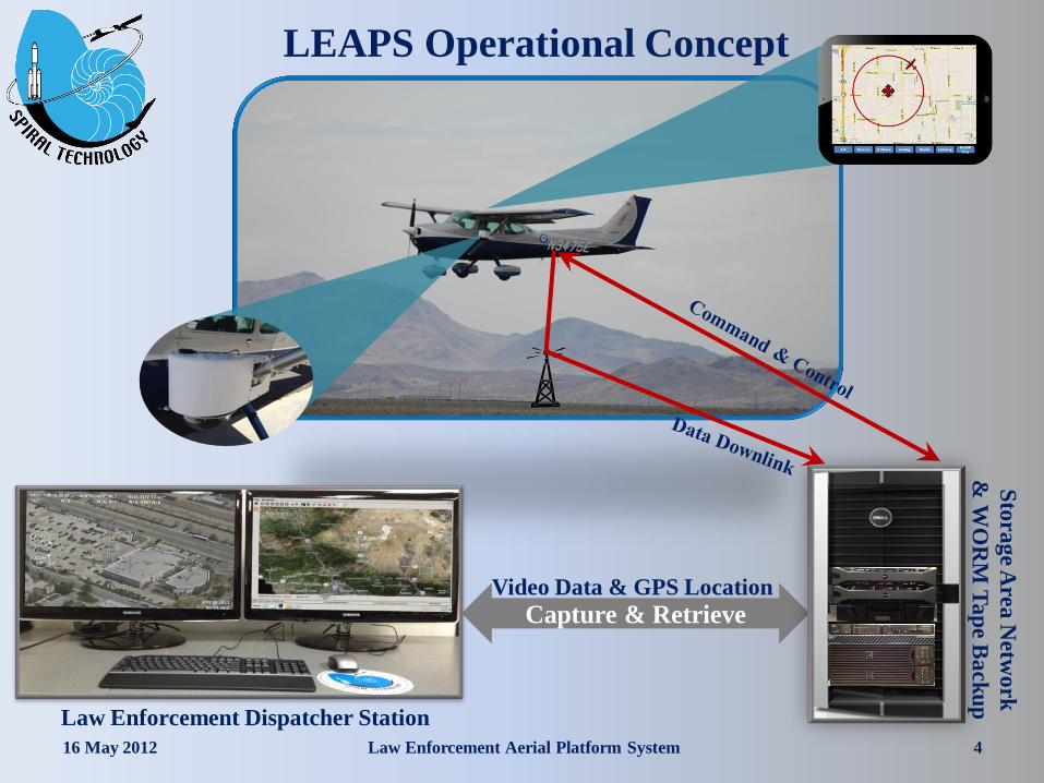
LEAPS Operational Concept
Capture & Retrieve
Law Enforcement Dispatcher Station
Video Data & GPS Location
Sto
rag
e Area
Netw
ork
& W
OR
M T
ap
e B
ack
up

Transmitting and Receiving Data
16 May 2012 Law Enforcement Aerial Platform System 5
The Airborne Camera
The Aircraft Antenna
Three Antennae on a 150’
Tower

The Flow of Information
16 May 2012 Law Enforcement Aerial Platform System 6

Dispatcher Station
16 May 2012 Law Enforcement Aerial Platform System 7
At the Dispatcher Station, LEAPS presents the following Information:
• Real-Time View from the Camera
• Map Presenting the Location of the aircraft and the camera view angle
• Camera Pointing and Control Information (pan & zoom)
• Aircraft Status

Concept of Operations
Pilot Tasking Tablet
16 May 2012 Law Enforcement Aerial Platform System 8
Desired
Ground Track Current Aircraft
Position
Point of
Interest
Ack Enroute OnScene Leaving Unable Loitering On/Off
Duty

Data Archival and Retrieval System
16 May 2012 Law Enforcement Aerial Platform System 9
• Real Time storage device has 12 Terabyte capacity which can be expandable to 192 Terabyte capacity.
• Video Storage Array (Tape Based) for archival of recorded video with write once, read many (WORM) media.
• Ability for Law Enforcement to “prune” archived video to catalog and maintain only that which is deemed necessary to support legal actions and playback functions.
• Equipment includes: 2 Cisco Switches
Cisco ASA Firewall
2 Uninterruptable Power Supplies
Storage Area Network Server
Storage Area Network
Write Once Read Many Tape Backup System

Video Archive & Retrieve
(Copy Event to DVD)
16 May 2012 Law Enforcement Aerial Platform System 10
Software to collect geo-referenced video and photo data in the field, and bring
that data into desktops and Web-based maps for improved decision making. :
• Improve access to critical decision-making information
• Simplify data recall and analysis
• Eliminate hours of video review and post processing

Sample Down-Linked Video
~ 1000 Ft. AGL @ Full Optical Zoom
16 May 2012 Law Enforcement Aerial Platform System 11

16 May 2012 Law Enforcement Aerial Platform System 12
Sample Down-Linked Video
~ 3000 Ft. AGL Tracking an Object