lead authority: surrey county council project title
TRANSCRIPT
RMA short form business case template – Feb 2020 Page 1 of 56
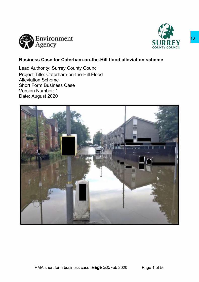
Business Case for Caterham-on-the-Hill flood alleviation scheme
Lead Authority: Surrey County Council
Project Title: Caterham-on-the-Hill Flood Alleviation Scheme Short Form Business Case Version Number: 1 Date: August 2020
Page 385
13

RMA short form business case template – Feb 2020 Page 2 of 56
BUSINESS CASE APPROVAL SHEET
1 Review & Technical Approval
Project title Caterham-on-the-Hill Flood Alleviation Scheme
Authority project reference ENV-12FDRENA/009 EA reference THC500E/000A/212A
Lead authority Surrey County Council Date of
submission
7th August 2020
Consultant Atkins Limited
‘I confirm that this project meets our quality assurance requirements, environmental obligations and Defra investment appraisal conditions, that all internal approvals, including member approval, have been completed and recommend we apply to the Environment Agency for capital grant and local levy in the sum of £1,945,297.
Job title Name Signature Date
Authority Project Executive
Doug Hill
Strategic Network Resilience Manager
Xxxxxxxxxxxxxxxxxxxxx
7/08/2020
‘I have reviewed this document and confirm that it meets the current business case guidelines for local authority and Internal Drainage Board applications.’
OBC reviewer
‘I confirm that the project is ready for assurance and that I have consulted with the Director of Business Finance’
Area Flood & Coastal Risk Manager
Assurance sign off - (Tick the appropriate box)
AFCRM Assurance Projects < £500k NPAS Assurance Projects £500k - £2m
Recommendation for approval Date
AFCRM or NPAS Chair
Project total as approved (£k)
Version Number
Project total made up of: Capital Grant (£k)
Levy (£k)
Other Contributions (£k)
2 Project Financial approval
Financial scheme of approval
Project total
Name Signature Date
Area Flood & Coastal Risk Manager
<£100k or <£1m (if GiA & Levy <£100k)
Page 386
13

RMA short form business case template – Feb 2020 Page 3 of 56
Director of Business Finance
All projects >£100k
Plus:
Area Director £100k- £1m
Director of Operations £1m -£10m
3 Further approvals (if applicable)
Date sent (or N/A)
Version number (if different)
Date approved (or N/A)
Final Comments
Page 387
13

RMA short form business case template – Feb 2020 Page 4 of 56
For FSoD Coordinator use only:
Page 388
13

RMA short form business case template – Feb 2020 Page 5 of 56
Business Case
Executive Summary
This business case has been produced to seek £1,900,000 to install property flood resilience (PFR) measures to 205 properties effected by flooding in Caterham Hill and Old Coulsdon, located in an upstream sub-drainage area of the Wandle catchment.
On 7th June 2016 over 80 internal and over 60 external property floods occurred in the catchment. Following this event, a multi-agency project board was setup following the flood event to manage flood risk activities in the area. Also, the community setup a flood action group, facilitated by the National Flood Forum. There is a high expectation within the community for actions to reduce this high flood risk.
An SOC published in March 2018 outlined the flooding mechanisms in the catchment through modelling and local evidence. The catchment is at high risk of surface water flooding particularly in high intensity rainfall storm events. A short-list of five options mainly based on flood storage were identified to reduce flooding. The analysis also concluded that there is limited space to intercept overland flow in this predominantly steep urban area.
The OBC appraisal process further explored these options for mitigating flood risk. PFR was identified as the most economically viable option for FDGiA funding. The scheme comprises of Property Flood Resilience (PFR) measures offered to 205 properties, as part of a suite of measures that the Project Board plan to undertake within the Caterham-on-the-Hill catchment. This option delivers a maximum of 169 Outcome Measure 2As (OM2As) over the 25-year duration of benefits.
This PFR business case is seeking FDGiA and levy to maximise outcome measures. Surrey County Council, Tandridge District Council and London Borough of Croydon are working on a parallel suite of intervention measures to reduce flood risk throughout the catchment including highway SuDS and community SuDS.
Page 389
13

RMA short form business case template – Feb 2020 Page 6 of 56
Approval Requested
This Outline Business Case (OBC) is being submitted by Surrey County Council (SCC) to seek Environment Agency approval of the preferred option for the Caterham-on-the-Hill Flood Alleviation Scheme (FAS) and recommendation for the project to progress.
The Caterham-on-the-Hill FAS is being managed as a partnership project, with a Project Board comprising of the following agencies:
• Environment Agency;
• Surrey County Council (SCC) (Lead Local Flood Authority (LLFA));
• London Borough of Croydon (LBC) (LLFA);
• Tandridge District Council (TDC); and
• Thames Water Utilities Limited (TWUL).
The scheme comprises of Property Flood Resilience (PFR) measures offered to 205 properties, as part of a suite of measures that the Project Board plan to undertake within the Caterham-on-the-Hill catchment. The Present Value (PV) cost of the scheme, assuming 100% uptake, is £1.9m and the PV benefits are £11.4m, giving a Benefit Cost Ratio (BCR) of 6 over a 25-year appraisal period. The business case for taking this option forward has been demonstrated to be robust in light of any reductions to the uptake rate, as well as to changes to assumptions on property threshold levels.
This option delivers a maximum of 169 Outcome Measure 2As (OM2As) over the 25-year duration of benefits and has a Partnership Funding (PF) score of 71%, calculated using the 2020 PF calculator and based on a PV cost for approval of £1.9m, with future costs included is £2.5m. Funding has already been received from the Flood and Coastal Erosion Risk Management Grant in Aid (FCERM GiA) to cover asset surveys, integrated catchment modelling and appraisal work. Funding has also been agreed from the Regional Flood and Coastal Committee (local levy). The PF calculator states that the maximum present value costs eligible FCERM GiA are £1.8m. This leaves external contributions of approximately £0.7m required to take the scheme forward, £0.2m towards the PV costs for approval and the current ongoing catchment maintenance costs of £0.5m over the next 25 years (future costs). This funding requirement assumes full uptake by all 205 properties.
Residents have been invited to return Expression of Interest (EoI) forms, with 83 positive responses received by the Project Board to date, equivalent to a 40% uptake. This uptake has a PV cost of £0.9m, and PV benefits of £4.9m, giving a BCR of 5.4. This uptake rate delivers 61 OM2As and has a PF score of 48% calculated using the 2020 PF calculator and based on a PV cost for approval of £0.9m, with future costs included is £1.5m. FCERM GiA eligibility (£0.7m) exceeds the £85k already claimed for this project, to cover the asset survey, integrated catchment modelling and appraisal work, therefore additional FCERM GiA funding can be requested for the next stage of the project. This leaves external contributions of approximately £0.7m required to take the scheme forward with this lower uptake rate, £0.2m towards the PV costs for approval and the current ongoing catchment maintenance costs of £0.5m over the next 25 years (future costs).
Page 390
13

RMA short form business case template – Feb 2020 Page 7 of 56
In parallel to progressing PFR, the Project Board have identified a range of additional interventions that would further reduce flood risk across the catchment. This includes implementing Sustainable Drainage on the highway, community raingardens and water butts. There are also community sustainable drainage projects being scoped for Hillcroft Primary School and for Queens Park Recreational Ground. These additional interventions identified both in the long and short listed options in Section 2, will be phased over the next 6 year cycle through a programme of targeted projects. Priority flood areas have been identified for these projects located in and adjacent to the low points throughout the catchment as indicated in the strategy section of this OBC. There is a longer term initiative where the evolving Local Planning policy will effect change in flood risk mitigation through local development. These works fall outside this Outline Business Case.
The agencies together with the flood action group are working together to extend the reach of the project and flood risk awareness to the wider community. This flood scheme was selected as a national DEFRA / EA pilot project entitled “Working together to adapt to a changing climate: flood and coast”. This project aims to review and learn how to effectively engage with community areas where there are increasing flood mitigation challenges due to climate change. This is being facilitated with resources from ICARUS who are contracted by DEFRA / EA as community engagement specialists. Results from this pilot project, including developing a collaborative community engagement and decision making framework, will be shared with other community groups at risk of flooding across the UK.
Page 391
13

RMA short form business case template – Feb 2020 Page 8 of 56
Strategic case
Site location
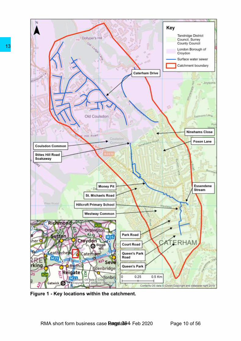
Caterham-on-the-Hill is in eastern Surrey, to the south of Old Coulsdon which is within the London Borough of Croydon. Both areas form part of the study area, with the county boundary located along the southern extent of Coulsdon Common. Caterham-on-the-Hill and Old Coulsdon are predominantly residential areas, with some shops and businesses in Caterham-on-the-Hill along the High Street and Chaldon Road.
The southern (upstream) part of the study area is within Tandridge District Council (TDC) part of SCC and the northern (downstream) part of the study area is within the London Borough of Croydon (LBC). Coulsdon Common, the common between Caterham-on-the-Hill and Caterham Drive is owned by the City of London. From here on, the study area will be referred to as the Caterham-on-the-Hill catchment. Key locations within the Caterham-on-the-Hill catchment as well as the county boundary are shown in Figure 1.
The Caterham-on-the-Hill FAS is being managed as a partnership project, with a Project Board comprising of the following agencies:
• Environment Agency;
• Surrey County Council (SCC) (Lead Local Flood Authority (LLFA));
• London Borough of Croydon (LBC) (LLFA);
• Tandridge District Council (TDC); and
• Thames Water Utilities Limited (TWUL).
Historic Flooding
Caterham-on-the-Hill has a history of flooding, most recently in June 2016.
Between 12:30-15:00 on 7th June 2016 an intense rainstorm occurred in the Caterham-on-the-Hill catchment. The recorded 72.6 mm of rainfall over a 2.5-hour storm duration (Surrey County Council, 2016) is greater than the entire monthly June average rainfall in this area. The Caterham Drive Section 19 report (London Borough of Croydon, 2017) details the rainfall records in Caterham Drive, Caterham-on-the-Hill and the surrounding area. This was a highly localised storm with the nearby Kenley rain gauge only recording 40mm in a 1-hour storm (London Borough of Croydon, 2017).
SCC, LBC and the City of London maintain historical records of flood incidents. These are summarised in Table 1 and shown on a map in the Options report (Appendix C). LBC do not maintain geographic information system (GIS) records of flood incidents, therefore LBC historic flood records are not displayed on the map. For full information on these records, please refer to the Options report (Appendix C).
Page 392
13

RMA short form business case template – Feb 2020 Page 9 of 56
Table 1 – Property flood history in Caterham-on-the-Hill.
Date Comments
1966 - 2007 8 incidents of external property flooding and 7 incidents of internal property flooding reported in LBC.
Winter 2013/14 11 incidents of internal property flooding reported in SCC.
June 2016 51 incidents of external property flooding and 75 incidents of internal property flooding reported in SCC.
13 incidents of external property flooding and 7 incidents of internal property flooding reported in LBC.
2017 2 incidents of external property flooding reported in LBC.
2020 3 incidents of external property flooding.
It is recognised that not all incidents of property flooding may have been reported to the local authority following each event.
Between December 2013 and November 2014, the City of London also reported 10 incidents of flooding on Coulsdon Common. The pressure of the water in the surface water system lifts the manhole cover of Stites Hill Soakaway, allowing water to flow onto the Common. It should be noted that these incidents do not directly result in property flooding, however, they demonstrate the frequency at which the capacity of the surface water network is exceeded.
Problem to address
Flooding within the catchment is dominated by surface water runoff, with one main surface water flow path and several minor flow paths. The main surface water flow path as shown in Figure 2, flows in a northerly direction from just upstream of the Queens Park recreation ground. The flow route then follows the path of the surface water sewer, along the bottom of the valley. This surface water sewer runs north from the northern boundary of Queens Park recreation ground, through the “Money Pit” (underground storage area) adjacent to St. Michaels Road and ends in Stites Hill Road soakaway. This soakaway has no controlled overflow mechanism. During historic flood events, the soakaway capacity has been exceeded, lifting the manhole cover and water has flooded onto Stites Hill Road and across Coulsdon Common.
A drainage ditch conveys surface water across Coulsdon Common from Stites Hill Road. It ends in a dug-out storage area with no apparent onward connection. Once the capacity of this storage area is exceeded, excess surface water runoff flows along Caterham Drive. There is also a second overland flow route onto Caterham Drive which crosses the eastern part of Coulsdon Common from Ninehams Close. There is a surface water drain conveying water north under Caterham Drive.
Page 393
13
RMA short form business case template – Feb 2020 Page 10 of 56
Figure 1 - Key locations within the catchment.
Foxon Lane
Page 394
13

RMA short form business case template – Feb 2020 Page 11 of 56
Figure 2 - Surface water flow routes within the catchment.
Page 395
13

RMA short form business case template – Feb 2020 Page 12 of 56
As part of the Caterham-on-the-Hill FAS Strategic Outline Case (SOC) (Atkins Limited, 2018), an Integrated Catchment Model (ICM) was built. This has been further developed throughout the OBC and has been used to assess the surface water flow routes and flood mechanisms in the Caterham-on-the-Hill catchment. The ICM includes representation of surface water and foul water flooding and the ways in which these flood sources interact. Further details about the development of the model can be found in the model build report (Appendix D).
The main flooding mechanisms in the catchment, as identified from data review and the ICM, and verified from anecdotal reports from historic flood events are:
• Urban drainage exceedance;
• Overland flow;
• Sheet runoff; and
• The soakaway function in the catchment is being exceeded. They should be maintained for their cumulative storage capacity. For more information on this, please see Options Report, Section 1.1.3.
At present SCC and LBC undertake maintenance work throughout the catchment to maintain a free-flowing surface water system as far as possible. These works are described further in Section 2. If these works were to cease, over time pipes, road gullies and soakaways block, siltation levels build in the “Money Pit” and the ditch across Coulsdon Common will become more vegetated. This scenario is referred to as ‘Do Nothing’ and assumes that no maintenance or repair activities are undertaken on any drainage assets within the catchment. This is a worst-case scenario and represents the economic baseline of this OBC.
The number of properties estimated to be at risk in a Do Nothing scenario, for a range of present day Annual Probability (AP) events are presented in Table 2. The property counts presented are cumulative, i.e. the 132 residential properties flooded internally in a 5% (1 in 20) AP event are included in the 188 flooded in a 2% (1 in 50) AP event. Properties at risk of internal flooding are also included in the counts of those at risk of external flooding. Thresholds of non-residential properties are typically low so no differentiation between internal and external flooding is made. Further details about the methodology used to derive property counts can be found in the Options report in Appendix C. The flood events presented in Table 2 correspond to the boundaries of the risk bands used to define Outcome Measure 2 (OM2) counts for the 2020 Partnership Funding (PF) calculator.
Table 2 - Number of properties estimated to be at risk in the Do Nothing.
Annual Probability (%) 5%
(1 in 20) 2%
(1 in 50) 1%
(1 in 100) 0.5%
(1 in 200)
Residential: external flooding 312 430 489 571
Residential: internal flooding 132 188 225 280
Non-residential: internal flooding 15 26 34 50
Flood risk in the catchment is expected to increase in the future because of climate change. A 20% increase in rainfall intensity (taken from the current 2016 Environment Agency climate change guidance) increases the total number of residential properties at risk of internal flooding in the Do Nothing 0.5% (1 in 200) AP from 280 to 309
Page 396
13

RMA short form business case template – Feb 2020 Page 13 of 56
properties. The effects of predicted climate change has been simulated in the ICM and is fully incorporated in the economic appraisal in line with current guidance (Environment Agency, 2016).
Business strategies
The need for investment in addressing flood risk in the Caterham-on-the-Hill catchment is supported by various plans and strategies.
Local Plans
Tandridge District Council’s Local Plan (2013-2033) (Tandridge District Council, 2017) will replace the existing Core Strategy (Tandridge District Coucil, 2008) and some detailed policies (Tandridge District Council, 2014). TDC’s Local Plan is currently being examined by the Planning Inspectorate. Once adopted it will set out the development strategy of the district up until 2033. LBC’s Local Plan (London Borough of Croydon, 2016) sets out the development strategy of the district up until 2036.
The Caterham-on-the-Hill FAS will help TDC and LBC to meet their local plan objectives by managing flood risk in a way which benefits communities, businesses and the environment.
Local Flood Risk Management Strategy (LFRMS)
SCC’s LFRMS (Surrey County Council, 2017) outlines the steps SCC are taking to manage flood risk. With the support of residents and businesses, SCC aim to increase the resilience of communities in several ways including influencing policy, empowering local people and investing in both natural and engineered flood alleviation schemes. The Caterham-on-the-Hill FAS aligns with the aspirations of SCC and will help them to achieve the objectives set out in the LFRMS.
Strategic Flood Risk Assessments (SFRA)
Caterham-on-the-Hill is located within the study area of the TDC Level 1 (JBA, 2017) and Level 2 (JBA, 2018) SFRA reports, while Caterham Drive is located within the study area of the LBC Level 1 (AECOM, 2015) and Level 2 (AECOM, 2016) SFRA reports. Any flood risk management options taken forward as part of the Caterham-on-the-Hill FAS will need to be designed in line with the guidance in all SFRA reports and the requirements of the National Planning Policy Framework (NPPF).
Tandridge District Council also requested a more detailed flood risk assessment of Caterham-on-the-Hill through the Level 2 SFRA. The LBC Level 2 SFRA provides information on the suitability of Sustainable Drainage Systems (SuDS). Consideration of SuDS across the catchment has been undertaken as part of the Caterham-on-the-Hill FAS.
Section 19 reports
Both SCC and LBC wrote Section 19 reports following the flood event that occurred in the Caterham-on-the-Hill catchment on 7th June 2016. The SCC Section 19 report (Surrey County Council, 2016) is focused on Caterham-on-the-Hill, while the LBC Section 19 report (London Borough of Croydon, 2017) is focused on Caterham Drive. Both Section 19 reports detail the actions of SCC (Lead RMA for Caterham-on-the-
Page 397
13

RMA short form business case template – Feb 2020 Page 14 of 56
Hill), LBC (Lead RMA for Caterham Drive), TDC, TWUL and the emergency services during and following the flood event. After the flooding, the National Flood Forum facilitated the setup of a Flood Action Group in Caterham-on-the-Hill to provide a mechanism for residents to improve communication with RMAs.
Several key recommendations of both Section 19 reports have been undertaken as part of this work, including:
• Collaborative working between LBC, SCC and TWUL should be further built upon through the newly created Multi-Agency Project Board;
• Investigate the ownership of the piped watercourse/surface water sewer network connections in-order to clarify maintenance responsibilities;
• Consider the use of SuDS in urban areas and upstream open parkland;
• Continue the options appraisal to mitigate flooding;
• Identify funding opportunities to contribute to future feasible schemes; and
• Residents should ensure their properties are protected for example using property flood resistance measures.
The reader is referred to each report for the full list of recommendations. The information gathered and reported in the Section 19 reports has been used alongside further information provided by residents to better understand the 2016 flood event and to validate the results of the ICM.
Surface Water Management Study (SWMS)
In 2013 Atkins were commissioned by SCC to undertake a SWMS (Atkins Limited, 2016) in the Caterham-on-the-Hill catchment. The SWMS reviewed existing drainage asset data and commissioned survey to fill information gaps. A high-level review of modelled and historic flooding and a high-level economic appraisal of baseline flood damages and conceptual option development were also included. The SWMS concluded that there are around 100 properties thought to be at risk of flooding from surface water in a 3.3% (1 in 30) AP flood event. A long list of conceptual options was developed to address this flood risk. The SWMS recommended that further work was carried out on the proposed options to determine which are most suitable and/or achievable. This recommendation has been followed with the commissioning of first the SOC and now this OBC.
Environmental considerations
As part of the SOC, a high-level desk study was undertaken to review the environmental risks, challenges and opportunities. This made use of the publicly available material from the MAGIC (Multi-agency Geographic Information for the Countryside) website (Natural England, 2017). The top environmental issues which may impact future schemes have been summarised in Table 3.
Table 3 - Key environmental challenges.
Key environmental issue Opportunities and approach to mitigation
The deciduous woodland on Coulsdon Common has been identified on Natural England’s priority habitats inventory. The project must ensure that the quality of this landscape is not compromised.
Avoid impacts through option selection and design where possible. If not, mitigate impacts through measures such as tree planting.
Opportunities to include habitat improvements as part of any scheme in this area, which could
Page 398
13

RMA short form business case template – Feb 2020 Page 15 of 56
provide biodiversity and amenity benefits as well as additional funding opportunities.
Queen’s Park recreation ground and Coulsdon Common are important open spaces for the local community. The project needs to ensure that the recreation and common land uses are not compromised.
Avoid impacts through option selection and design where possible. If not, mitigate impacts through measures such as sensitive landscaping and planting.
Opportunities to include habitat and recreational improvements as part of any scheme in this area, which could provide biodiversity and amenity benefits as well as additional funding opportunities.
There are several listed buildings within the study area. The coal tax post on Stites Hill Road is a Grade II listed structure. These buildings / structures must not be negatively impacted.
No adverse impacts on listed buildings are anticipated and some may benefit from the reduction in flood risk. Any work along Stites Hill Road should be designed to avoid impacts on the coal tax post.
Caterham-on-the-Hill is a predominantly urban area with many impermeable surfaces. This must be considered in the development of any options.
Green infrastructure and SuDS options offer opportunities for environmental enhancements including habitat creation, water quality improvements and amenity benefits.
Investment objectives
The objectives for the Caterham-on-the-Hill FAS, taken from the SOC are to:
• Promote a jointly funded scheme to reduce surface water flood risk to people and property. This should be achieved through RMA partnership working and involvement of the local community, for example through the local Flood Action Group;
• Promote a scheme which provides the best possible economic standard of protection and where possible is resilient and adaptive to climate change;
• Identify options which help create a better place and work with the community to maximise environmental outcomes for people and wildlife; and
• Minimise and mitigate for both adverse impacts and any safety or environmental risks that may result from the scheme.
Main benefits
The proposed investment will reduce flood risk to properties in Caterham-on-the-Hill and Old Coulsdon, specifically those residential properties currently at very significant risk throughout the catchment. Investment could result in up to 205 properties in Caterham-on-the-Hill having reduced flood risk. Investment would ensure these properties are protected under a changing climate.
Page 399
13
RMA short form business case template – Feb 2020 Page 16 of 56
Main risks
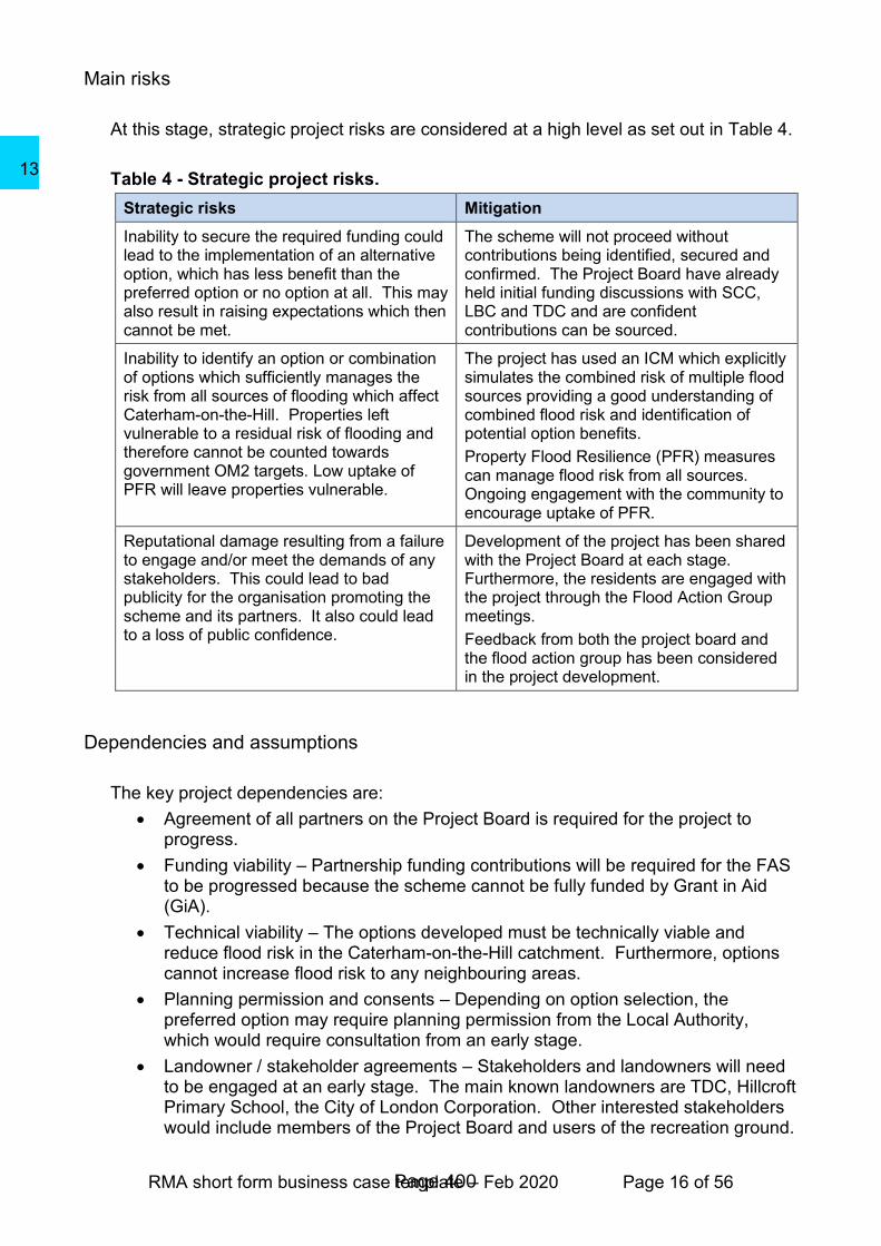
At this stage, strategic project risks are considered at a high level as set out in Table 4.
Table 4 - Strategic project risks.
Strategic risks Mitigation
Inability to secure the required funding could lead to the implementation of an alternative option, which has less benefit than the preferred option or no option at all. This may also result in raising expectations which then cannot be met.
The scheme will not proceed without contributions being identified, secured and confirmed. The Project Board have already held initial funding discussions with SCC, LBC and TDC and are confident contributions can be sourced.
Inability to identify an option or combination of options which sufficiently manages the risk from all sources of flooding which affect Caterham-on-the-Hill. Properties left vulnerable to a residual risk of flooding and therefore cannot be counted towards government OM2 targets. Low uptake of PFR will leave properties vulnerable.
The project has used an ICM which explicitly simulates the combined risk of multiple flood sources providing a good understanding of combined flood risk and identification of potential option benefits.
Property Flood Resilience (PFR) measures can manage flood risk from all sources. Ongoing engagement with the community to encourage uptake of PFR.
Reputational damage resulting from a failure to engage and/or meet the demands of any stakeholders. This could lead to bad publicity for the organisation promoting the scheme and its partners. It also could lead to a loss of public confidence.
Development of the project has been shared with the Project Board at each stage. Furthermore, the residents are engaged with the project through the Flood Action Group meetings.
Feedback from both the project board and the flood action group has been considered in the project development.
Dependencies and assumptions
The key project dependencies are:
• Agreement of all partners on the Project Board is required for the project to progress.
• Funding viability – Partnership funding contributions will be required for the FAS to be progressed because the scheme cannot be fully funded by Grant in Aid (GiA).
• Technical viability – The options developed must be technically viable and reduce flood risk in the Caterham-on-the-Hill catchment. Furthermore, options cannot increase flood risk to any neighbouring areas.
• Planning permission and consents – Depending on option selection, the preferred option may require planning permission from the Local Authority, which would require consultation from an early stage.
• Landowner / stakeholder agreements – Stakeholders and landowners will need to be engaged at an early stage. The main known landowners are TDC, Hillcroft Primary School, the City of London Corporation. Other interested stakeholders would include members of the Project Board and users of the recreation ground.
Page 400
13

RMA short form business case template – Feb 2020 Page 17 of 56
• Landowner permissions - If PFR is taken forward as the preferred option, individual landowner / property owner permission will be required.
Page 401
13
RMA short form business case template – Feb 2020 Page 18 of 56
Economic case
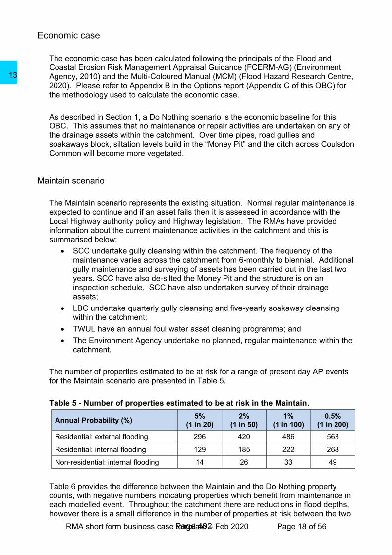
The economic case has been calculated following the principals of the Flood and Coastal Erosion Risk Management Appraisal Guidance (FCERM-AG) (Environment Agency, 2010) and the Multi-Coloured Manual (MCM) (Flood Hazard Research Centre, 2020). Please refer to Appendix B in the Options report (Appendix C of this OBC) for the methodology used to calculate the economic case.
As described in Section 1, a Do Nothing scenario is the economic baseline for this OBC. This assumes that no maintenance or repair activities are undertaken on any of the drainage assets within the catchment. Over time pipes, road gullies and soakaways block, siltation levels build in the “Money Pit” and the ditch across Coulsdon Common will become more vegetated.
Maintain scenario
The Maintain scenario represents the existing situation. Normal regular maintenance is expected to continue and if an asset fails then it is assessed in accordance with the Local Highway authority policy and Highway legislation. The RMAs have provided information about the current maintenance activities in the catchment and this is summarised below:
• SCC undertake gully cleansing within the catchment. The frequency of the maintenance varies across the catchment from 6-monthly to biennial. Additional gully maintenance and surveying of assets has been carried out in the last two years. SCC have also de-silted the Money Pit and the structure is on an inspection schedule. SCC have also undertaken survey of their drainage assets;
• LBC undertake quarterly gully cleansing and five-yearly soakaway cleansing within the catchment;
• TWUL have an annual foul water asset cleaning programme; and
• The Environment Agency undertake no planned, regular maintenance within the catchment.
The number of properties estimated to be at risk for a range of present day AP events for the Maintain scenario are presented in Table 5.
Table 5 - Number of properties estimated to be at risk in the Maintain.
Annual Probability (%) 5%
(1 in 20) 2%
(1 in 50) 1%
(1 in 100) 0.5%
(1 in 200)
Residential: external flooding 296 420 486 563
Residential: internal flooding 129 185 222 268
Non-residential: internal flooding 14 26 33 49
Table 6 provides the difference between the Maintain and the Do Nothing property counts, with negative numbers indicating properties which benefit from maintenance in each modelled event. Throughout the catchment there are reductions in flood depths, however there is a small difference in the number of properties at risk between the two
Page 402
13
RMA short form business case template – Feb 2020 Page 19 of 56
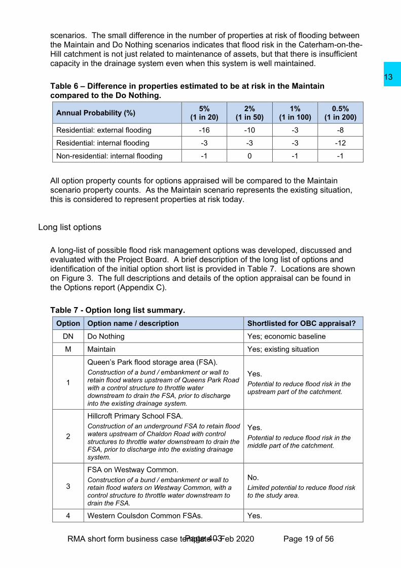
scenarios. The small difference in the number of properties at risk of flooding between the Maintain and Do Nothing scenarios indicates that flood risk in the Caterham-on-the-Hill catchment is not just related to maintenance of assets, but that there is insufficient capacity in the drainage system even when this system is well maintained.
Table 6 – Difference in properties estimated to be at risk in the Maintain compared to the Do Nothing.
Annual Probability (%) 5%
(1 in 20) 2%
(1 in 50) 1%
(1 in 100) 0.5%
(1 in 200)
Residential: external flooding -16 -10 -3 -8
Residential: internal flooding -3 -3 -3 -12
Non-residential: internal flooding -1 0 -1 -1
All option property counts for options appraised will be compared to the Maintain scenario property counts. As the Maintain scenario represents the existing situation, this is considered to represent properties at risk today.
Long list options
A long-list of possible flood risk management options was developed, discussed and evaluated with the Project Board. A brief description of the long list of options and identification of the initial option short list is provided in Table 7. Locations are shown on Figure 3. The full descriptions and details of the option appraisal can be found in the Options report (Appendix C).
Table 7 - Option long list summary.
Option Option name / description Shortlisted for OBC appraisal?
DN Do Nothing Yes; economic baseline
M Maintain Yes; existing situation
1
Queen’s Park flood storage area (FSA).
Construction of a bund / embankment or wall to retain flood waters upstream of Queens Park Road with a control structure to throttle water downstream to drain the FSA, prior to discharge into the existing drainage system.
Yes.
Potential to reduce flood risk in the upstream part of the catchment.
2
Hillcroft Primary School FSA.
Construction of an underground FSA to retain flood waters upstream of Chaldon Road with control structures to throttle water downstream to drain the FSA, prior to discharge into the existing drainage system.
Yes.
Potential to reduce flood risk in the middle part of the catchment.
3
FSA on Westway Common.
Construction of a bund / embankment or wall to retain flood waters on Westway Common, with a control structure to throttle water downstream to drain the FSA.
No.
Limited potential to reduce flood risk to the study area.
4 Western Coulsdon Common FSAs. Yes.
Page 403
13

RMA short form business case template – Feb 2020 Page 20 of 56
Construction of a series of three bunds / embankments or walls to retain flood waters upstream of Caterham Drive with control structures to throttle water downstream to drain the FSAs, prior to discharge.
Potential to reduce flood risk to Caterham Drive.
5
Eastern Coulsdon Common FSAs.
Construction of a series of nine bunds / embankments or walls to retain flood waters upstream of Caterham Drive with control structures to throttle water downstream to drain the FSAs, prior to discharge.
Yes.
Potential to reduce flood risk to Caterham Drive.
6
Removal of the Money Pit.
Removal of the Money Pit and replace with a pipe to maintain flow conveyance along the main surface water drain. Could replace with an above-ground storage area if levels permit. Reduces the ongoing maintenance costs associated with underground storage.
No.
Removal of the Money Pit increases flood risk in the catchment.
7
Offline FSA at xxxxxxxxxxxxxx.
Construction of a FSA at xxxxxxxxxxxx to reduce the risk of flooding to the properties North of Coulsdon Common.
No.
Limited potential to reduce flood risk to the study area.
8
Caterham Drive FSA.
Construction of a FSA downstream of Caterham Drive.
No.
Limited potential to reduce flood risk to the study area.
9
Divert water from Money Pit to golf course.
Divert water out of the catchment from the piped watercourse (at the Money Pit) to Surrey National Golf Club. Storage would need to be provided to prevent any increase in flood risk downstream.
No.
A very deep, and therefore prohibitively expensive, diversion pipe would be required because of the catchment topography.
10
Divert water along Foxon Lane.
Divert water from the piped watercourse in a new drain under Money Road and north along Foxon Lane, discharging onto Coulsdon Common. In order to accommodate the increased flow across Coulsdon Common without increasing downstream flood risk, this option would need to be combined with Option 5.
No.
A very deep, and therefore prohibitively expensive, diversion pipe would be required because of the catchment topography.
11
Divert water from Ninehams Road to the Whyteleafe catchment.
Divert water from the piped watercourse in a new drain under Ninehams Road and Salmons Lane West, discharging into the Whyteleafe catchment. This option would need to be combined with a storage option.
No.
Flood risk would increase in the Whyteleafe catchment.
12
Upsize the existing sewer network.
Upsize the existing pipe network or installation of additional pipes, creating a “super sewer” for the urban area.
No.
Risk of increasing downstream flood risk and likely to be prohibitively expensive.
13
Rebuild Stites Hill Road soakaway.
Excavate and re-build Stites Hill Road soakaway to increase the discharge capacity.
No.
Short term solution, unlikely to provide any meaningful increase in the standard of protection to existing residential properties.
14 Stites Hill Road soakaway overflow. No.
Page 404
13

RMA short form business case template – Feb 2020 Page 21 of 56
Install overflow on Stites Hill Road soakaway. General recommendation that this option is delivered by partners outside of the OBC as option would not reduce flood risk but would help to manage the risk of the manhole cover lifting.
15
Installation of Silt traps at key location within the catchment.
Installation of silt trap in manhole chambers downstream of Queen’s Park, upstream of the Money Pit and the Stites Hill Road soakaway.
No.
General recommendation that silt traps are delivered by partners outside of the OBC.
16
Secure the Stites Hill Road soakaway manhole cover.
Bolt down the manhole cover of Stites Hill Road soakaway to prevent the cover lifting when the soakaway surcharges.
No.
Pressure would increase in the pipe system, increasing the health and safety risk.
17
Raise the level of Stites Hill Road.
Raise the level of Stites Hill Road adjacent to the soakaway and construct a culvert under the road to convey flows, reducing the risk of road flooding.
No.
Likely to be prohibitively expensive and will only benefit the road.
18
Kerb raising.
Raise the kerbs in key locations within the catchment, to confine more water to the roads and reduce the inundation of properties at low depths.
No.
Properties are not just at risk of flooding from the roads. Flood water also comes through back gardens.
19
Litter campaign.
Reduce blockages in the surface water drainage system caused by litter.
No.
General recommendation that a litter campaign is delivered by partners outside of the OBC.
20
Sustainable Drainage Systems (SuDS).
SuDS installed both in new developments and retrofitted to existing buildings for example water butts. Other green infrastructure installed in streets, for example rain gardens.
Yes.
Potential to attenuate surface water runoff across the catchment.
21
Natural Flood Management (NFM).
Small scale land management measures on open land through the catchment to increase storage within the catchment and slow downstream flow. Potential limited in urban area.
Yes.
Could be considered in conjunction with other options and / or progressed outside of the OBC. Limited flood risk benefits but provides wider natural capital benefits.
22
Property Flood Resilience (PFR) measures
Installation of flood resistance measures to help stop water getting into a property and / or flood resilience measures to help minimise the damage flood water can cause. Residential properties would be eligible if they are modelled to be at risk of flooding in the 5% (1 in 20) AP event and / or those with recent reported flood history.
Yes.
Effective at managing flood risk from multiple sources / flow routes. Fall-back option where other options do not reduce flooding and where there is flood history.
23
Flood warning systems
Install telemetry within the Caterham-on-the-Hill catchment to create a flood warning system. Educate the residents to make them aware of the new flood warning system.
No.
There is no obvious place to install telemetry within the catchment and warning times would be very limited.
Page 405
13

RMA short form business case template – Feb 2020 Page 22 of 56
Figure 3 - Option long list.
Page 406
13

RMA short form business case template – Feb 2020 Page 23 of 56
Short list options
Where there was uncertainty over the technical performance of some of the long list options (Option 2, and Option 21), high level appraisal of technical viability and deliverability was undertaken, as follows.
• Option 2: Hillcroft Primary School FSA
o This option was conceptualised as part of the SOC. It has been identified as an area for future development, therefore, there is uncertainty relating to future land use and how storage on this site could be achieved.
o This option has not been discounted from assessment in the future, however, until more is known about the re-development plans in the area, this option has not been considered any further as part of this OBC.
• Option 21: NFM
o The catchment is heavily urbanised and so there are limited areas with potential for in-channel NFM measures as the surface water drainage is mostly in a piped underground system under roads, gardens and between properties;
o The main source of flood water is surface water runoff from roads, roofs and gardens, therefore there is a limited scope to introduce land management changes;
o NFM measures on Coulsdon Common could however still usefully slow-the-flow through this area. Although the volume of water reaching this downstream part of the catchment means that NFM measures are expected to have limited flood risk benefits, they could provide wider biodiversity and amenity benefits. It is therefore recommended that these are taken forward by partners outside of this OBC.
For the reasons listed above, both options were discounted from further, more detailed assessment within this OBC.
The following options were taken forward for detailed appraisal including; modelling, costing and economic calculations:
• Do Nothing;
• Maintain;
• Option 1: Queens Park FSA;
• Option 4: Western Coulsdon Common FSA;
• Option 5: Eastern Coulsdon Common FSA;
• Option 20: SuDS; and
• Option 22: PFR measures.
Options 4 and 5 were also considered in combination. Option 20 and 22 were further broken down into sub-options. For more information on how Option 20 (SuDS) was broken down and then appraised, please see the Options report (Appendix C). Following the outcomes from this SuDS appraisal work, the Project Board decided to progress SuDS separately as part of a wider suite of measures within the catchment. Whilst the options were assessed as being economically viable, more than half of the
Page 407
13

RMA short form business case template – Feb 2020 Page 24 of 56
option benefits were generated from wider multiple benefits rather than flood risk benefits. As a result, this limits the amount of FCERM GIA funding that can be requested. The Project Board decided to continue these options with their Project Partners, including Thames Water, LBC and TDC. Therefore, they are not reported on further within this OBC report.
Option 22 (PFR) was broken down as follows:
• Initial PFR Option (129 properties):
o Residential properties modelled to be at risk of flooding in the Maintain scenario 5% (1 in 20) AP event.
• PFR (129 properties as above) + Option 1 (Queens Park FSA)
• PFR Option 1 (80 properties):
o Based on historic property flood records only (June 2016). This includes two non-residential properties.
• PFR Option 2 (183 properties):
o 129 properties included in the initial PFR option;
o An additional two non-residential properties modelled to be at risk of flooding in the 5% (1 in 20) AP event have been selected by the Project Board to be included;
o Any adjacent semi-detached and terraced properties to those eligible; and
o 20 properties located on the main flow route which were recorded to have flooded internally in June 2016 but are not modelled to be at risk in the 5% (1 in 20) AP event.
• PFR Option 3 (205 properties):
o 129 properties included in the initial PFR option;
o An additional three non-residential properties modelled to be at risk of flooding in the 5% (1 in 20) AP event have been selected by the Project Board to be included in this option;
o Any adjacent semi-detached and terraced properties to those eligible; and
o All properties which were recorded to have flooded internally in June 2016 regardless of modelled flood risk.
There are technical, environmental and social matters that relate to each of the short-listed options that must be considered. These are summarised in Table 8. More information on each option is given in Appendix A in the Options report (Appendix C).
Table 8 - Technical, environmental and social matters pertinent to each option.
Do Nothing
• Under the Do Nothing scenario, both properties and roads are at risk of flooding in frequent rainfall events. This flood risk is expected to increase in the future with climate change;
• No change to existing environmental and social matters. No carbon cost; and
• Reduction in operation and maintenance costs.
Maintain
Page 408
13
RMA short form business case template – Feb 2020 Page 25 of 56
• Under the existing scenario, both properties and roads are at risk of flooding in frequent rainfall events. This flood risk is expected to increase in the future with climate change;
• Maintenance could result in short term road closures. Gully and manhole access is not possible to guarantee; and
• No change to existing environmental or social matters. Low carbon cost option with the exception of maintenance of the “Money Pit” which requires transportation of the sediment removed from the structure.
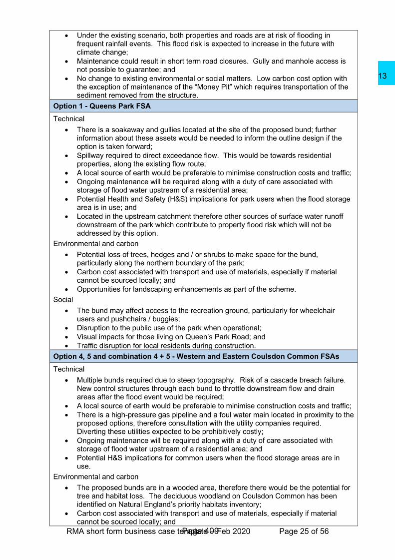
Option 1 - Queens Park FSA
Technical
• There is a soakaway and gullies located at the site of the proposed bund; further information about these assets would be needed to inform the outline design if the option is taken forward;
• Spillway required to direct exceedance flow. This would be towards residential properties, along the existing flow route;
• A local source of earth would be preferable to minimise construction costs and traffic;
• Ongoing maintenance will be required along with a duty of care associated with storage of flood water upstream of a residential area;
• Potential Health and Safety (H&S) implications for park users when the flood storage area is in use; and
• Located in the upstream catchment therefore other sources of surface water runoff downstream of the park which contribute to property flood risk which will not be addressed by this option.
Environmental and carbon
• Potential loss of trees, hedges and / or shrubs to make space for the bund, particularly along the northern boundary of the park;
• Carbon cost associated with transport and use of materials, especially if material cannot be sourced locally; and
• Opportunities for landscaping enhancements as part of the scheme.
Social
• The bund may affect access to the recreation ground, particularly for wheelchair users and pushchairs / buggies;
• Disruption to the public use of the park when operational;
• Visual impacts for those living on Queen’s Park Road; and
• Traffic disruption for local residents during construction.
Option 4, 5 and combination 4 + 5 - Western and Eastern Coulsdon Common FSAs
Technical
• Multiple bunds required due to steep topography. Risk of a cascade breach failure. New control structures through each bund to throttle downstream flow and drain areas after the flood event would be required;
• A local source of earth would be preferable to minimise construction costs and traffic;
• There is a high-pressure gas pipeline and a foul water main located in proximity to the proposed options, therefore consultation with the utility companies required. Diverting these utilities expected to be prohibitively costly;
• Ongoing maintenance will be required along with a duty of care associated with storage of flood water upstream of a residential area; and
• Potential H&S implications for common users when the flood storage areas are in use.
Environmental and carbon
• The proposed bunds are in a wooded area, therefore there would be the potential for tree and habitat loss. The deciduous woodland on Coulsdon Common has been identified on Natural England’s priority habitats inventory;
• Carbon cost associated with transport and use of materials, especially if material cannot be sourced locally; and
Page 409
13

RMA short form business case template – Feb 2020 Page 26 of 56
• Opportunities for landscaping enhancements as part of the scheme.
Social
• The bunds may affect access to the Common, particularly for wheelchair users and pushchairs / buggies; and
• Disruption to the public use of the Common when operational.
Option 22 - PFR measures
Technical
• Low-cost option for where other community-wide options are not suitable;
• Provides protection to properties at an individual level;
• Temporary measures e.g. flood barriers for doors require enough warning time for residents to act; very limited warning time in the Caterham-on-the-Hill catchment therefore there would not be much time to implement these measures, making permanent measures such as flood doors more appropriate; and
• Residual risk of flooding should any temporary measures not be deployed in time or correctly, if residents have not maintained their measures or if adjacent terraced or semi-detached properties do not have measures in place.
Environment
• No significant adverse environmental impacts, but also no environmental opportunities.
Social
• Must be owned, operated and maintained by individual property owners;
• Temporary measures will require resident action during a flood event to implement; and
• Current Environment Agency guidance for PFR is focused on residential properties only; this does not however preclude commercial properties from being included in a SCC-led scheme.
Economic appraisal
The results from the ICM were used to undertake a depth damage economic assessment. The economic appraisal followed the principles of the FCERM-AG (Environment Agency, 2010), as updated by supplementary guidance on the Defra website and the new appraisal guidance published by the Environment Agency in April 2020. Depth damage data was taken from the MCM (Flood Hazard Research Centre, 2020). All options were modelled in the ICM other than PFR. The PFR option damages / benefits were calculated using the Maintain model results and the PFR methodology from the MCM. The impact of climate change was included in accordance with guidance available at the time of this appraisal (Environment Agency, 2016). A detailed explanation of how the economic appraisal was undertaken is included in Appendix B of the option report (Appendix C to this OBC).
Option benefits
The economic flood benefit assessment included calculation of the following:
• Direct benefits to residential and non-residential properties as a result of reduction in flood depths and flood risk probability and therefore reduced Annual Average Damages (AADs);
• In-direct benefits from reductions in evacuation costs, emergency services costs, vehicle damages and mental health flood losses; and
• The benefits of a reduced risk of flooding on the human intangible effects of health and stress.
Page 410
13
RMA short form business case template – Feb 2020 Page 27 of 56
In accordance with Treasury guidance, AADs were discounted over a 100-year appraisal period using the Treasury variable discount rate to generate a Present Value damage (PVd) for each option. Health related damages were discounted using an updated Treasury Green Book (2018) discount rate in line with the updated economic appraisal guidance (Environment Agency, 2020). The PV benefit (PVb) of each short-listed option was then calculated as the difference between the short-listed option PVd against the Do Nothing PVd. Damages and benefits are provided in Table 13 below.
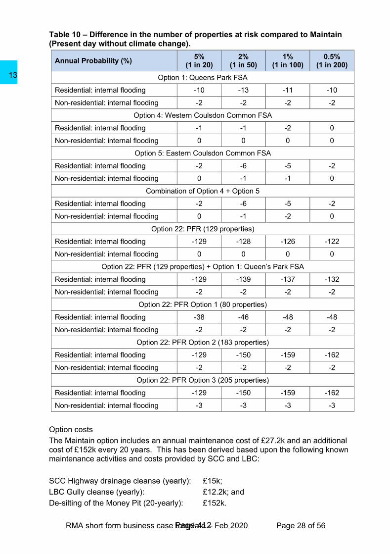
Option benefits can also be quantified and better understood through property count information. Table 9 provides the cumulative counts of properties modelled to be at risk of internal flooding (above floor level flooding) in the present day Maintain scenario. This is repeated from Table 5 for ease of reference. To understand the benefit of each option, the counts of properties modelled to be at risk of internal flooding for each option is compared to those modelled in the Maintain scenario. Although the Do Nothing is the economic baseline, the Maintain scenario represents the existing situation and so best represents the number of properties at risk today. This cumulative difference is shown in Table 10 with negative numbers indicating properties which benefit from each option.
Table 9 - Number of properties estimated to be at risk in the Maintain.
Annual Probability (%) 5%
(1 in 20) 2%
(1 in 50) 1%
(1 in 100) 0.5%
(1 in 200)
Residential: internal flooding 129 185 222 268
Non-residential: internal flooding 14 26 33 49
Page 411
13
RMA short form business case template – Feb 2020 Page 28 of 56
Table 10 – Difference in the number of properties at risk compared to Maintain (Present day without climate change).
Annual Probability (%) 5%
(1 in 20) 2%
(1 in 50) 1%
(1 in 100) 0.5%
(1 in 200)
Option 1: Queens Park FSA
Residential: internal flooding -10 -13 -11 -10
Non-residential: internal flooding -2 -2 -2 -2
Option 4: Western Coulsdon Common FSA
Residential: internal flooding -1 -1 -2 0
Non-residential: internal flooding 0 0 0 0
Option 5: Eastern Coulsdon Common FSA
Residential: internal flooding -2 -6 -5 -2
Non-residential: internal flooding 0 -1 -1 0
Combination of Option 4 + Option 5
Residential: internal flooding -2 -6 -5 -2
Non-residential: internal flooding 0 -1 -2 0
Option 22: PFR (129 properties)
Residential: internal flooding -129 -128 -126 -122
Non-residential: internal flooding 0 0 0 0
Option 22: PFR (129 properties) + Option 1: Queen’s Park FSA
Residential: internal flooding -129 -139 -137 -132
Non-residential: internal flooding -2 -2 -2 -2
Option 22: PFR Option 1 (80 properties)
Residential: internal flooding -38 -46 -48 -48
Non-residential: internal flooding -2 -2 -2 -2
Option 22: PFR Option 2 (183 properties)
Residential: internal flooding -129 -150 -159 -162
Non-residential: internal flooding -2 -2 -2 -2
Option 22: PFR Option 3 (205 properties)
Residential: internal flooding -129 -150 -159 -162
Non-residential: internal flooding -3 -3 -3 -3
Option costs
The Maintain option includes an annual maintenance cost of £27.2k and an additional cost of £152k every 20 years. This has been derived based upon the following known maintenance activities and costs provided by SCC and LBC:
SCC Highway drainage cleanse (yearly): £15k;
LBC Gully cleanse (yearly): £12.2k; and
De-silting of the Money Pit (20-yearly): £152k.
Page 412
13
RMA short form business case template – Feb 2020 Page 29 of 56
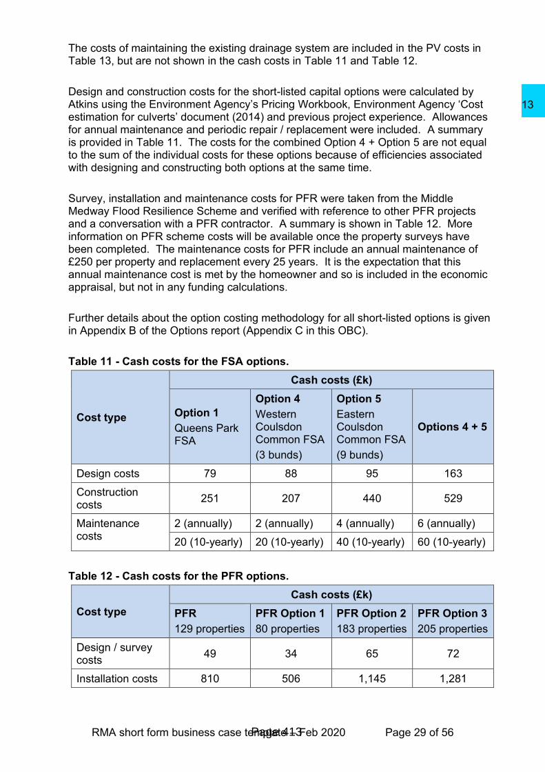
The costs of maintaining the existing drainage system are included in the PV costs in Table 13, but are not shown in the cash costs in Table 11 and Table 12.
Design and construction costs for the short-listed capital options were calculated by Atkins using the Environment Agency’s Pricing Workbook, Environment Agency ‘Cost estimation for culverts’ document (2014) and previous project experience. Allowances for annual maintenance and periodic repair / replacement were included. A summary is provided in Table 11. The costs for the combined Option 4 + Option 5 are not equal to the sum of the individual costs for these options because of efficiencies associated with designing and constructing both options at the same time.
Survey, installation and maintenance costs for PFR were taken from the Middle Medway Flood Resilience Scheme and verified with reference to other PFR projects and a conversation with a PFR contractor. A summary is shown in Table 12. More information on PFR scheme costs will be available once the property surveys have been completed. The maintenance costs for PFR include an annual maintenance of £250 per property and replacement every 25 years. It is the expectation that this annual maintenance cost is met by the homeowner and so is included in the economic appraisal, but not in any funding calculations.
Further details about the option costing methodology for all short-listed options is given in Appendix B of the Options report (Appendix C in this OBC).
Table 11 - Cash costs for the FSA options.
Cost type
Cash costs (£k)
Option 1
Queens Park FSA
Option 4
Western Coulsdon Common FSA
(3 bunds)
Option 5
Eastern Coulsdon Common FSA
(9 bunds)
Options 4 + 5
Design costs 79 88 95 163
Construction costs
251 207 440 529
Maintenance costs
2 (annually) 2 (annually) 4 (annually) 6 (annually)
20 (10-yearly) 20 (10-yearly) 40 (10-yearly) 60 (10-yearly)
Table 12 - Cash costs for the PFR options.
Cost type
Cash costs (£k)
PFR
129 properties
PFR Option 1
80 properties
PFR Option 2
183 properties
PFR Option 3
205 properties
Design / survey costs
49 34 65 72
Installation costs 810 506 1,145 1,281
Page 413
13

RMA short form business case template – Feb 2020 Page 30 of 56
The whole-life costs for each option have been discounted to a PV over a 100-year appraisal period. No Optimism Bias (OB) was applied to the costs of maintaining the existing drainage system as these are known costs provided by the current asset maintainers. A 60% OB has been applied to all FSA option costs. A reduced level of OB (30%) has been applied to the PFR costs to reflect the lower level of risk associated with this option. The OB applied is considered appropriate to the stage of design and the information available when costing these options, as well as the risks currently identified.
Option economic summary
The costs, damages, benefits and benefit cost ratio (BCR) of each of the short-listed options are displayed in Table 13. All options in Table 13 return BCR values which are greater than 1 indicating that the option benefits outweigh the costs and hence the options are economically viable. Table 14 provides further economic summary information for the various PFR options.
Table 13 – Costs, benefits and benefit cost ratios of the shortlisted options.
Option PV Costs (£k) PV damages (£k) PV benefits (£k) BCR
Do Nothing 0 38,591
Maintain 975 35,514 3,180 3.3
Option 1 Queens Park FSA
1,650 33,087 5,744 3.5
Option 4 Western Coulsdon Common FSA
1,596 34,977 3,724 2.3
Option 5 Eastern Coulsdon Common FSA
2,129 33,863 4,879 2.3
Options 4 + 5 2,536 33,693 5,050 2.0
PFR
(129 properties) 3,918 13,710 24,983 6.4
Although Options 1, 4, 5 and the combination of Options 4 and 5 are economically viable (BCR greater than one), Table 13 shows that each of these options have large residual damages, all above £30m, and provide relatively low benefits, all below £6m. This is because the location of these options and the steep nature of the catchment, means that each of these options provides benefit to a relatively small area, as follows:
• Option 1 provides flood risk benefit to properties located on Queens Park Road, Court Road and Park Road in the very upstream of the catchment; and
• Option 4, Option 5 and the combination of Options 4 and 5 provide flood risk benefit to properties located on Caterham Drive in the very downstream of the catchment.
In addition to the localised nature of the benefits, Options 4 and 5 are technically very difficult as they require numerous high bunds, in locations where there are underground utilities (including a high-pressure gas main) and they would not be in keeping with the existing landscape of Coulsdon Common.
Page 414
13

RMA short form business case template – Feb 2020 Page 31 of 56
In contrast, PFR, has a much higher benefit (£25m) and a much lower residual damage (£14m). This is because PFR offers individual resilience to properties at the highest flood risk throughout the catchment. It was therefore agreed with the Project Board to explore options for delivering PFR, and to economically appraise these options. The results of this are shown in Table 14. The first row in this table (PFR 129 properties) has been copied from Table 13 for reference.
Table 14 – PFR Option costs, benefits and benefit cost ratios over 100 year appraisal period.
Option PV Costs (£k) PV damages (£k) PV benefits (£k) BCR
PFR
(129 properties) 3,918 13,710 24,983 6.4
PFR
(129 properties)
+ Option 1
4,467 13,286 25,408 5.7
PFR Option 1
(80 properties) 2,813 26,843 11,851 4.2
PFR Option 2
(183 properties) 5,136 12,442 26,272 5.1
PFR Option 3
(205 properties) 5,632 12,247 26,447 4.7
All PFR scenarios have BCRs above one, this demonstrates that they are economically viable options. The economically preferred option can be determined by applying the FCERM-AG decision rule as discussed in Section 2.7 below.
Non-financial benefits appraisal
This project has the potential to achieve benefits beyond the direct flood risk reductions achieved by the options. Examples include improving community awareness and preparedness of flood risk and strengthening the reputation of the RMAs.
The PFR measures are also expected to increase homeowner peace of mind, reducing the emotional and mental health impacts associated with repeated flooding. Research into the mental health impacts of flooding has found that flooded residents are six times more likely to suffer mental health issues and with flooded homes sometimes uninhabitable for over one year, it is an underlying cause of homelessness. This OBC appraisal has included the mental health impacts of flooding and benefits of the options using the recently defined methodology (Environment Agency, 2020).
The short-listed options provide limited opportunities for providing environmental enhancement or habitat creation. The FSAs could provide opportunities for landscaping enhancements as part of the scheme; however, they also have the potential for loss of trees, hedges and / or shrubs to make space for the bunds. By taking forward PFR instead of the FSA options, these potential environmental and recreational impacts are avoided. It is recommended that RMAs and the community
Page 415
13
RMA short form business case template – Feb 2020 Page 32 of 56
work together within this catchment to find and deliver environmental opportunities outside of this OBC.
Preferred way forward
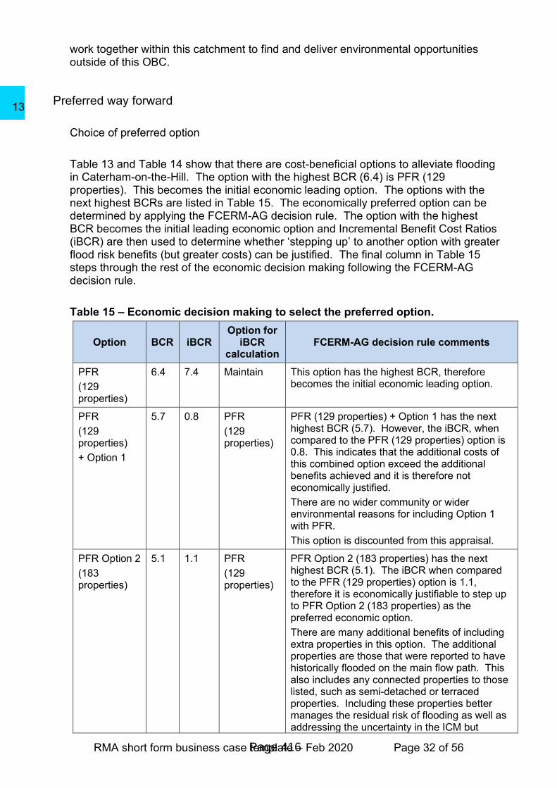
Choice of preferred option
Table 13 and Table 14 show that there are cost-beneficial options to alleviate flooding in Caterham-on-the-Hill. The option with the highest BCR (6.4) is PFR (129 properties). This becomes the initial economic leading option. The options with the next highest BCRs are listed in Table 15. The economically preferred option can be determined by applying the FCERM-AG decision rule. The option with the highest BCR becomes the initial leading economic option and Incremental Benefit Cost Ratios (iBCR) are then used to determine whether ‘stepping up’ to another option with greater flood risk benefits (but greater costs) can be justified. The final column in Table 15 steps through the rest of the economic decision making following the FCERM-AG decision rule.
Table 15 – Economic decision making to select the preferred option.
Option BCR iBCR Option for
iBCR calculation
FCERM-AG decision rule comments
PFR
(129 properties)
6.4 7.4 Maintain This option has the highest BCR, therefore becomes the initial economic leading option.
PFR
(129 properties)
+ Option 1
5.7 0.8 PFR
(129 properties)
PFR (129 properties) + Option 1 has the next highest BCR (5.7). However, the iBCR, when compared to the PFR (129 properties) option is 0.8. This indicates that the additional costs of this combined option exceed the additional benefits achieved and it is therefore not economically justified.
There are no wider community or wider environmental reasons for including Option 1 with PFR.
This option is discounted from this appraisal.
PFR Option 2
(183 properties)
5.1 1.1 PFR
(129 properties)
PFR Option 2 (183 properties) has the next highest BCR (5.1). The iBCR when compared to the PFR (129 properties) option is 1.1, therefore it is economically justifiable to step up to PFR Option 2 (183 properties) as the preferred economic option.
There are many additional benefits of including extra properties in this option. The additional properties are those that were reported to have historically flooded on the main flow path. This also includes any connected properties to those listed, such as semi-detached or terraced properties. Including these properties better manages the residual risk of flooding as well as addressing the uncertainty in the ICM but
Page 416
13
RMA short form business case template – Feb 2020 Page 33 of 56
Option BCR iBCR Option for
iBCR calculation
FCERM-AG decision rule comments
including historical flooding as part of the criteria for selection.
This becomes the economic leading option.
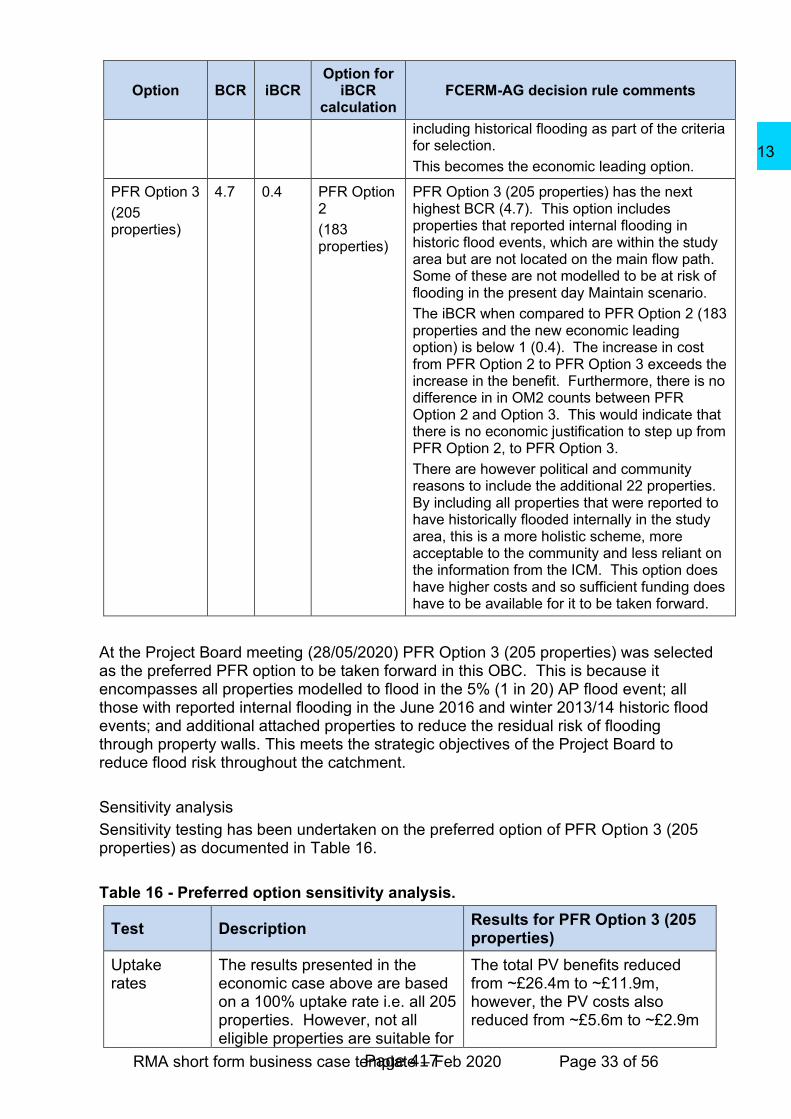
PFR Option 3
(205 properties)
4.7 0.4 PFR Option 2
(183 properties)
PFR Option 3 (205 properties) has the next highest BCR (4.7). This option includes properties that reported internal flooding in historic flood events, which are within the study area but are not located on the main flow path. Some of these are not modelled to be at risk of flooding in the present day Maintain scenario.
The iBCR when compared to PFR Option 2 (183 properties and the new economic leading option) is below 1 (0.4). The increase in cost from PFR Option 2 to PFR Option 3 exceeds the increase in the benefit. Furthermore, there is no difference in in OM2 counts between PFR Option 2 and Option 3. This would indicate that there is no economic justification to step up from PFR Option 2, to PFR Option 3.
There are however political and community reasons to include the additional 22 properties. By including all properties that were reported to have historically flooded internally in the study area, this is a more holistic scheme, more acceptable to the community and less reliant on the information from the ICM. This option does have higher costs and so sufficient funding does have to be available for it to be taken forward.
At the Project Board meeting (28/05/2020) PFR Option 3 (205 properties) was selected as the preferred PFR option to be taken forward in this OBC. This is because it encompasses all properties modelled to flood in the 5% (1 in 20) AP flood event; all those with reported internal flooding in the June 2016 and winter 2013/14 historic flood events; and additional attached properties to reduce the residual risk of flooding through property walls. This meets the strategic objectives of the Project Board to reduce flood risk throughout the catchment.
Sensitivity analysis
Sensitivity testing has been undertaken on the preferred option of PFR Option 3 (205 properties) as documented in Table 16.
Table 16 - Preferred option sensitivity analysis.
Test Description Results for PFR Option 3 (205 properties)
Uptake rates
The results presented in the economic case above are based on a 100% uptake rate i.e. all 205 properties. However, not all eligible properties are suitable for
The total PV benefits reduced from ~£26.4m to ~£11.9m, however, the PV costs also reduced from ~£5.6m to ~£2.9m
Page 417
13

RMA short form business case template – Feb 2020 Page 34 of 56
PFR measures because of the building type and design. This would be identified as part of individual property surveys not yet undertaken as part of this OBC. Furthermore, not all residents are willing to engage in such a scheme.
Eligible properties were written to and invited to complete an EoI form. At the time of completing this OBC, 83 properties (40%) had returned the EoI form. The economic appraisal was re-run to calculate the costs and benefits of a scheme based on this uptake.
and therefore the BCR reduced from 4.7 to 4.1.
This analysis has shown that even with reduced uptake rates, this option is still economically viable.
Property threshold levels
Residential threshold levels have been assumed to be 0.15m above ground level. This has been validated as part of visual observations on a site visit, but no detailed property threshold survey has been undertaken.
Test A
Reduction of assumed threshold levels to 0.1m.
Test B
Increase of assumed threshold levels to 0.2m.
Test A
Increased the number of properties modelled to be at risk in a 5% (1 in 20) AP event from 129 to 175. This test has been undertaken with the same 205 properties included in the PFR Option. The reduction in assumed property threshold increases the benefits from ~£26.4m to ~£33.4m. This strengthens the business case for this option.
Test B
Reduced the number of properties modelled to be at risk in a 5% (1 in 20) AP event from 129 to 98. This test has been undertaken with the same 205 properties included in the PFR Option. The increase in assumed property threshold reduces the benefits from ~£26.4m to ~£19.3m and reduces the BCR from 4.7 to 3.4. This shows that the scheme’s economic viability is unaffected if property thresholds are slightly higher than assumed in the appraisal.
PFR effectiveness
PFR effectiveness has been assumed to be 75% (Flood Hazard Research Centre, 2013).
Test A
Test A
The increase in assumed PFR effectiveness increases the benefits from ~£26.4m to
Page 418
13

RMA short form business case template – Feb 2020 Page 35 of 56
Increase of PFR effectiveness to 100%.
Test B
Reduction of PFR effectiveness to 50%.
~£34.1m. This strengthens the business case for this option.
Test B
The reduction in assumed PFR effectiveness reduces the benefits from ~£26.4m to ~£18.8m and reduces the BCR from 4.7 to 3.3. This shows that the scheme’s economic viability remains unaffected if the assumption of PFR effectiveness is reduced to 50%.
Outcome Measures
The OM1 (option benefits) for PFR Option 3 (205 properties) and the OM1 benefits for these property counts based on those 83 properties which had returned an Expression of Interest (EoI) form at the time of preparing this OBC over a 25-year Duration of Benefits (DofB) are set out in Table 17. This includes the split between the people benefits (OM1B), and the non-people related benefits OM1s. This OM1 value does not include quantification of any wider non-flood damages avoided benefits. The DofB is defined as the period of time until there are future costs (for example for asset upgrade or in the case of PFR measures, full replacement) greater than 20% of the initial capital costs. For PFR options, this is 25 years.
Table 17 - Outcome measure 1.
Outcome measure PFR Option 3 (205 properties)
PFR EOI uptake (83 / 205 (40%)
properties)
PV benefits (100-year appraisal period)
£26,447k £11,859k
DofB (years) 25 25
Total OM1 over DofB £11,360k £4,883k
People related impacts (OM1B) over DofB
£3,795k £1,665k
Non-people related OM1 £7,565k £3,218k
Table 18 provides OM2A property counts assuming 100% uptake of PFR by the 205 properties. Table 19 provides these property counts based on those 83 properties which had returned an Expression of Interest (EoI) form at the time of preparing this OBC. The PF calculator requires counts of properties for the “before” and “after” scenarios. The “before” counts are based on the present day Maintain scenario. The “after” counts include a 10% increase in rainfall intensity which is the current projected impact of climate change at the end of the 25-year DofB. All properties in the Caterham-on-the-Hill catchment are located in areas classified as 60% least deprived. In accordance with the PF calculator guidance, only those properties which move flood risk band are included in the OM2 counts. This is why they do not match property counts provided elsewhere in this business case.
Page 419
13
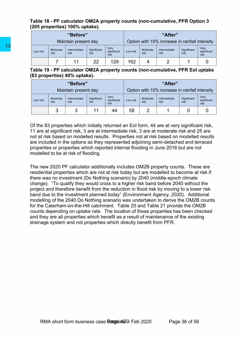
RMA short form business case template – Feb 2020 Page 36 of 56
Table 18 - PF calculator OM2A property counts (non-cumulative, PFR Option 3 (205 properties) 100% uptake).
“Before”
Maintain present day
“After”
Option with 10% increase in rainfall intensity
Low risk Moderate risk
Intermediate risk
Significant risk
Very significant risk
Low risk Moderate risk
Intermediate risk
Significant risk
Very significant risk
7 11 22 129 162 4 2 1 0
Table 19 - PF calculator OM2A property counts (non-cumulative, PFR EoI uptake (83 properties) 40% uptake).
“Before”
Maintain present day
“After”
Option with 10% increase in rainfall intensity
Low risk Moderate risk
Intermediate risk
Significant risk
Very significant risk
Low risk Moderate risk
Intermediate risk
Significant risk
Very significant risk
3 3 11 44 58 2 1 0 0
Of the 83 properties which initially returned an EoI form, 44 are at very significant risk, 11 are at significant risk, 3 are at intermediate risk, 3 are at moderate risk and 25 are not at risk based on modelled results. Properties not at risk based on modelled results are included in the options as they represented adjoining semi-detached and terraced properties or properties which reported internal flooding in June 2016 but are not modelled to be at risk of flooding.
The new 2020 PF calculator additionally includes OM2B property counts. These are residential properties which are not at risk today but are modelled to become at risk if there was no investment (Do Nothing scenario) by 2040 (middle-epoch climate change). “To qualify they would cross to a higher risk band before 2040 without the project and therefore benefit from the reduction in flood risk by moving to a lower risk band due to the investment planned today” (Environment Agency, 2020). Additional modelling of the 2040 Do Nothing scenario was undertaken to derive the OM2B counts for the Caterham-on-the-Hill catchment. Table 20 and Table 21 provide the OM2B counts depending on uptake rate. The location of these properties has been checked and they are all properties which benefit as a result of maintenance of the existing drainage system and not properties which directly benefit from PFR.
Page 420
13
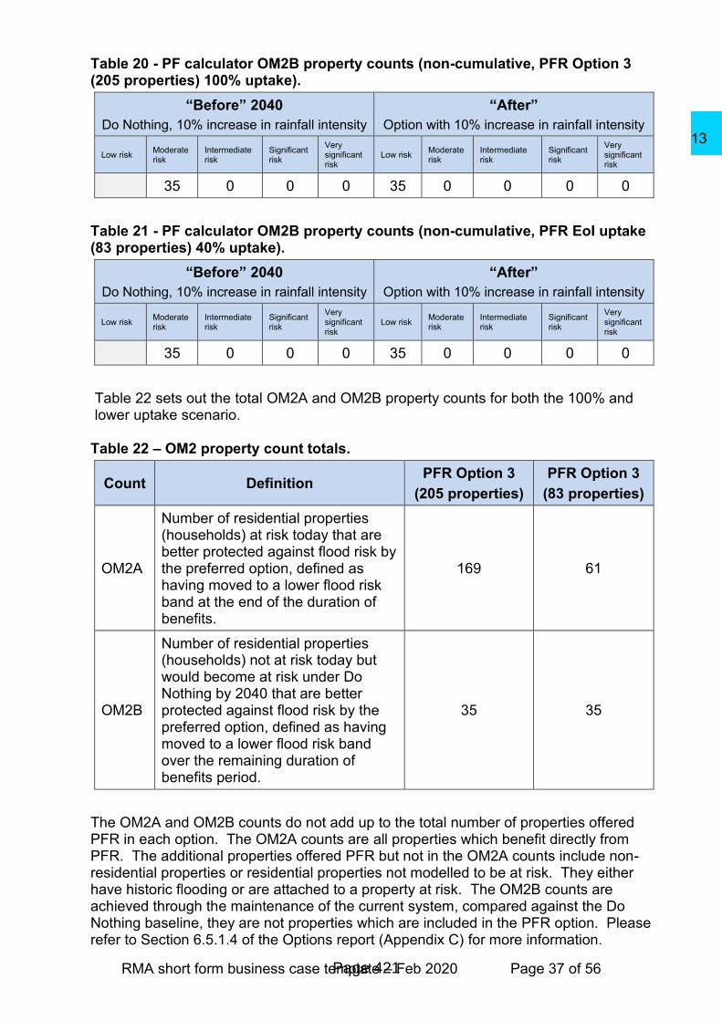
RMA short form business case template – Feb 2020 Page 37 of 56
Table 20 - PF calculator OM2B property counts (non-cumulative, PFR Option 3 (205 properties) 100% uptake).
“Before” 2040
Do Nothing, 10% increase in rainfall intensity
“After”
Option with 10% increase in rainfall intensity
Low risk Moderate risk
Intermediate risk
Significant risk
Very significant risk
Low risk Moderate risk
Intermediate risk
Significant risk
Very significant risk
35 0 0 0 35 0 0 0 0
Table 21 - PF calculator OM2B property counts (non-cumulative, PFR EoI uptake (83 properties) 40% uptake).
“Before” 2040
Do Nothing, 10% increase in rainfall intensity
“After”
Option with 10% increase in rainfall intensity
Low risk Moderate risk
Intermediate risk
Significant risk
Very significant risk
Low risk Moderate risk
Intermediate risk
Significant risk
Very significant risk
35 0 0 0 35 0 0 0 0
Table 22 sets out the total OM2A and OM2B property counts for both the 100% and lower uptake scenario.
Table 22 – OM2 property count totals.
Count Definition PFR Option 3
(205 properties)
PFR Option 3
(83 properties)
OM2A
Number of residential properties (households) at risk today that are better protected against flood risk by the preferred option, defined as having moved to a lower flood risk band at the end of the duration of benefits.
169 61
OM2B
Number of residential properties (households) not at risk today but would become at risk under Do Nothing by 2040 that are better protected against flood risk by the preferred option, defined as having moved to a lower flood risk band over the remaining duration of benefits period.
35 35
The OM2A and OM2B counts do not add up to the total number of properties offered PFR in each option. The OM2A counts are all properties which benefit directly from PFR. The additional properties offered PFR but not in the OM2A counts include non-residential properties or residential properties not modelled to be at risk. They either have historic flooding or are attached to a property at risk. The OM2B counts are achieved through the maintenance of the current system, compared against the Do Nothing baseline, they are not properties which are included in the PFR option. Please refer to Section 6.5.1.4 of the Options report (Appendix C) for more information.
Page 421
13
RMA short form business case template – Feb 2020 Page 38 of 56
Commercial case
Procurement strategy The Environment Agency’s National PFR framework has been used to identify lot 3 (survey and fit) PFR contractors. A competitive tender will be made using the EA framework. SCC will apply for “approval to procure” through the SCC Cabinet. The SCC procurement team will work with the LBC procurement team to define how to take forward this multi-agency business case. The contractor will be required to provide passive PFR measures. The contractor will be used to undertake the property surveys and to supply and install the PFR measures. Ongoing engagement with the property owners will either be undertaken by the Project Board or by a consultant on the Environment Agency PFR framework commissioned to do this work on behalf of the Project Board.
Key contractual terms and risk allocation Construction is relatively low risk and use of the specialist and experienced contractor will reduce the risk of construction related issues. The PFR contractor will take the responsibility of the detailed survey of the properties as well as their subsequent design, supply and installation. Where appropriate it is recommended that PFR products installed are KiteMarked, achieving or exceeding the British standard PAS 1188:2014. Furthermore, a post installation survey is recommended to ensure that all measures have been provided and that property owners are aware of the function of the measures and how to maintain them. In combination, this will help to ensure that, as long as they are well installed, maintained and in a good condition, the products will perform to the best standard possible. A contractual arrangement would be created to ensure that the installations have an adequate period of warranty. SCC’s legal and procurement team will advise the project team if required. A key contractual term would be to specify that the measures would either be automatic or fixed, without the need for installation by the resident prior to a flood event. The PFR contractor will be required to submit a detailed list of the proposed measures for each property for project board approval.
Efficiencies and commercial arrangements Efficiencies will be identified at all stages of the project. SCC intend to deliver this Caterham-on-the-Hill scheme working with the LBC as part of the Project Board. The scheme includes properties in both SCC and the LBC. Working together as part of one scheme is expected to provide efficiencies in relation to management time, PFR contractor time and expenses (during both the survey and installation phases) and enabling the sharing of and actions on lessons learnt.
Page 422
13

RMA short form business case template – Feb 2020 Page 39 of 56
Financial case
Financial Summary
This PFR business case is seeking FDGiA and levy to maximise outcome measures. Surrey County Council, Tandridge District Council and London Borough of Croydon are working on funding a parallel suite of intervention measures to reduce flood risk throughout the catchment including highway SuDS and a range of community SuDS.
The methodology for calculation of project costs is outlined in Section 2.5 of the Economic case with future details provided in the Options report (Appendix C). The risk contingency is currently based on a 30% optimism bias (OB), which is considered appropriate for PFR measures.
The financial summary for the preferred option of PFR (205 properties) is provided in Table 23. The whole-life cash costs cover the 25-year duration of benefits, all future costs relate to the future costs of maintaining the existing drainage system and do not have OB applied. The whole-life cash cost column also includes all study costs associated with the model build and development of the SOC and OBC. The SOC and OBC study costs and the future existing drainage system maintenance costs are excluded from the total project costs for approval column as they have been separately funded. Both columns in Table 23 exclude maintenance of the PFR measures as these costs would be incurred by property owners and funding is not being sought for this.
Table 23 – Preferred option financial summary.
1Whole-life
cash cost (£k)
2Total Project cost
(approval) (£k)
Cost up to OBC3 243
Exc previous applications
Costs after OBC
Salary costs 0 0
Cost of Professional Advice 20 20
Site investigation and survey 62 62
Construction 1,271 1,271
Supervision Included in construction cost Included in construction cost
Environmental mitigation4 0 0
Land purchase & compensation 0 0
Other5 0 0
Risk Contingency (See s.12 of the Grant Memorandum)
Risk or Optimism Bias6 (30%) 406 406
(Cash) N/a
Page 423
13

RMA short form business case template – Feb 2020 Page 40 of 56
1Whole-life
cash cost (£k)
2Total Project cost
(approval) (£k)
Future cost (construction + maintenance)
886
Optimism Bias on future cost7 0
Project total cost 2,888 1,7598
Notes
1. This column shows the cash, i.e., undiscounted, values and includes all future costs over the design life including any study costs approved under an FCERM7.
2. The costs in this column are cash values. 3. The whole life cash cost column includes any study costs approved under an
FCERM7 and the development cost of the OBC. The Total project cost (approval) column does not include study costs as these have already been approved under an FCERM7. It does include the OBC development cost.
4. The cost of environmental enhancement is contained within the other cost elements and not shown separately.
5. Add further rows as necessary for individual headings. A cumulative miscellaneous cost should not be more than 5% of the total.
6. Note that the allowance for risk and/or optimism bias is part of the project approval but must be claimed separately when needed using the FCERM4 application. See supporting information for further explanation.
7. The allowance for risk and optimism bias applicable to future construction and maintenance is shown separately from current risk and optimism bias to account for uncertainty.
8. This is the value of the project that will be approved and appear on the FCERM2.
Funding sources The scheme is requesting Flood and Coastal Erosion Risk Management Grant in Aid (FCERM GiA) within the next 6-year area programme. Table 24 details the results of the PF calculator which has been completed for the preferred option of PFR (205 properties). This is based on a 25-year duration of benefits and therefore the PV costs and benefits used for the partnership funding calculations are different to those reported for the economic case above (which is for a 100-year appraisal period). A copy of the PF calculator is provided in Appendix A.
Page 424
13
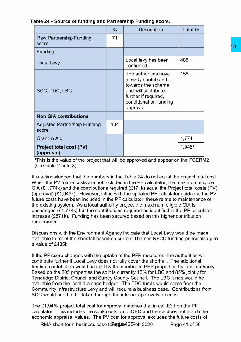
RMA short form business case template – Feb 2020 Page 41 of 56
Table 24 - Source of funding and Partnership Funding score.
% Description Total £k
Raw Partnership Funding score
71
Funding:
Local Levy Local levy has been
confirmed. 485
SCC, TDC, LBC
The authorities have already contributed towards the scheme and will contribute further if required, conditional on funding approval.
158
Non GiA contributions
Adjusted Partnership Funding score
104
Grant in Aid 1,774
Project total cost (PV) (approval)
1,9451
1This is the value of the project that will be approved and appear on the FCERM2 (see table 2 note 8).
It is acknowledged that the numbers in the Table 24 do not equal the project total cost. When the PV future costs are not included in the PF calculator, the maximum eligible GiA (£1,774k) and the contributions required (£171k) equal the Project total costs (PV) (approval) (£1,945k). However, inline with the updated PF calculator guidance the PV future costs have been included in the PF calculator, these relate to maintenance of the existing system. As a local authority project the maximum eligible GiA is unchanged (£1,774k) but the contributions required as identified in the PF calculator increase (£571k). Funding has been secured based on this higher contribution requirement. Discussions with the Environment Agency indicate that Local Levy would be made available to meet the shortfall based on current Thames RFCC funding principals up to a value of £485k. If the PF score changes with the uptake of the PFR measures, the authorities will contribute further if Local Levy does not fully cover the shortfall. The additional funding contribution would be split by the number of PFR properties by local authority. Based on the 205 properties the split is currently 15% for LBC and 85% jointly for Tandridge District Council and Surrey County Council. The LBC funds would be available from the local drainage budget. The TDC funds would come from the Community Infrastructure Levy and will require a business case. Contributions from SCC would need to be taken through the internal approvals process. The £1,945k project total cost for approval matches that in cell E31 on the PF calculator. This includes the sunk costs up to OBC and hence does not match the economic appraisal values. The PV cost for approval excludes the future costs of
Page 425
13
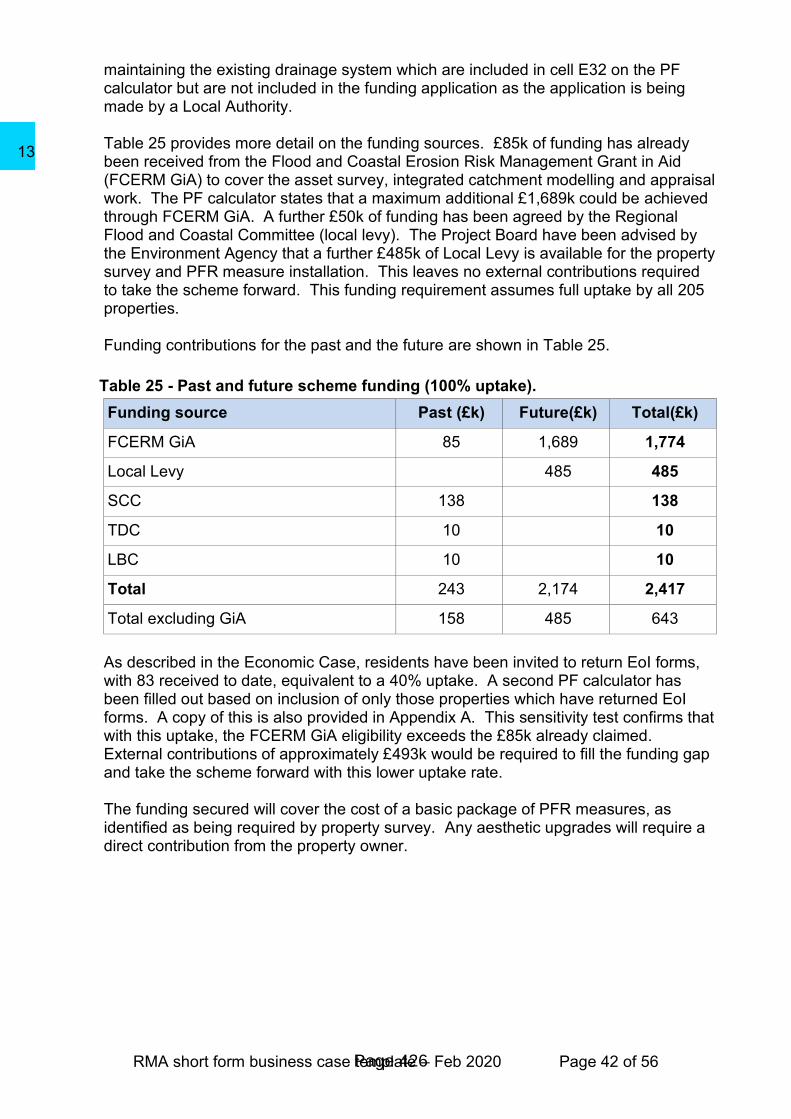
RMA short form business case template – Feb 2020 Page 42 of 56
maintaining the existing drainage system which are included in cell E32 on the PF calculator but are not included in the funding application as the application is being made by a Local Authority. Table 25 provides more detail on the funding sources. £85k of funding has already been received from the Flood and Coastal Erosion Risk Management Grant in Aid (FCERM GiA) to cover the asset survey, integrated catchment modelling and appraisal work. The PF calculator states that a maximum additional £1,689k could be achieved through FCERM GiA. A further £50k of funding has been agreed by the Regional Flood and Coastal Committee (local levy). The Project Board have been advised by the Environment Agency that a further £485k of Local Levy is available for the property survey and PFR measure installation. This leaves no external contributions required to take the scheme forward. This funding requirement assumes full uptake by all 205 properties.
Funding contributions for the past and the future are shown in Table 25.
Table 25 - Past and future scheme funding (100% uptake).
Funding source Past (£k) Future(£k) Total(£k)
FCERM GiA 85 1,689 1,774
Local Levy 485 485
SCC 138 138
TDC 10 10
LBC 10 10
Total 243 2,174 2,417
Total excluding GiA 158 485 643
As described in the Economic Case, residents have been invited to return EoI forms, with 83 received to date, equivalent to a 40% uptake. A second PF calculator has been filled out based on inclusion of only those properties which have returned EoI forms. A copy of this is also provided in Appendix A. This sensitivity test confirms that with this uptake, the FCERM GiA eligibility exceeds the £85k already claimed. External contributions of approximately £493k would be required to fill the funding gap and take the scheme forward with this lower uptake rate.
The funding secured will cover the cost of a basic package of PFR measures, as identified as being required by property survey. Any aesthetic upgrades will require a direct contribution from the property owner.
Page 426
13

RMA short form business case template – Feb 2020 Page 43 of 56
Management case
Project management and schedule The property surveys and installation of PFR measures will be project managed by SCC working with LBC and the PFR contractor. Key project dates are summarised in Table 26.
Table 26 - Key project dates.
Activity Indicative date
Approval of OBC October 2020
PFR contractor appointment November 2020
Property surveys
Assumptions:
• 0.5 months to arrange surveys.
• Property surveys usually take 1-2h, assumed 4 surveys / day, therefore 2.5 months.
• 1 month for contractor to write up reporting.
January 2020 to April 2021
Installation of PFR measures
Assumptions:
• 3 months for legal agreement with residents.
• 1 month to arrange installation.
• PFR measure installation takes 2/3 days per property, assumed 2 properties / week and 2 installation teams, therefore 12 months.
• 1-month risk allowance.
May 2021 to September 2022
Scheme completed October 2022
Benefits realisation Scheme benefit values are summarised in Table 27. These are given for the 25-year DofB as used in the PF calculator and so are different from those presented in the economic case of this OBC. Climate change is included in the calculation of both OM1 and OM2. Benefits will be realised once the PFR measures have been installed. Property owners will own and be responsible for the PFR measures.
Page 427
13
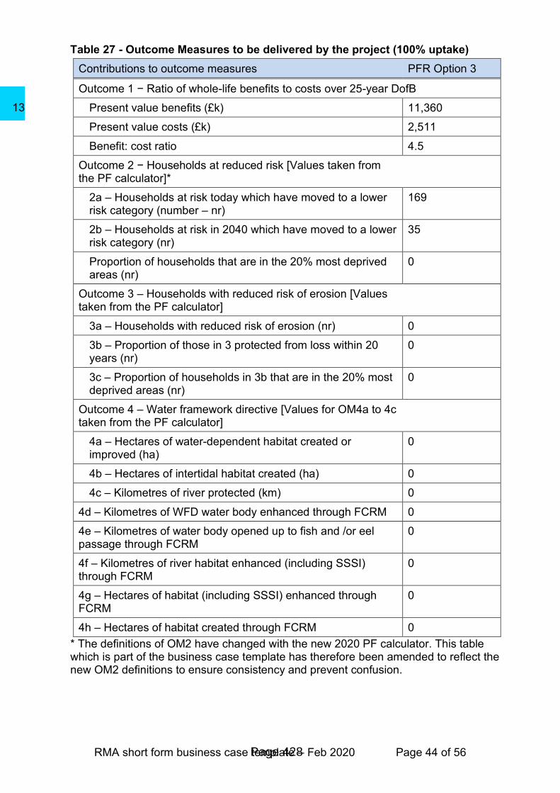
RMA short form business case template – Feb 2020 Page 44 of 56
Table 27 - Outcome Measures to be delivered by the project (100% uptake)
Contributions to outcome measures PFR Option 3
Outcome 1 − Ratio of whole-life benefits to costs over 25-year DofB
Present value benefits (£k) 11,360
Present value costs (£k) 2,511
Benefit: cost ratio 4.5
Outcome 2 − Households at reduced risk [Values taken from the PF calculator]*
2a – Households at risk today which have moved to a lower risk category (number – nr)
169
2b – Households at risk in 2040 which have moved to a lower risk category (nr)
35
Proportion of households that are in the 20% most deprived areas (nr)
0
Outcome 3 – Households with reduced risk of erosion [Values taken from the PF calculator]
3a – Households with reduced risk of erosion (nr) 0
3b – Proportion of those in 3 protected from loss within 20 years (nr)
0
3c – Proportion of households in 3b that are in the 20% most deprived areas (nr)
0
Outcome 4 – Water framework directive [Values for OM4a to 4c taken from the PF calculator]
4a – Hectares of water-dependent habitat created or improved (ha)
0
4b – Hectares of intertidal habitat created (ha) 0
4c – Kilometres of river protected (km) 0
4d – Kilometres of WFD water body enhanced through FCRM 0
4e – Kilometres of water body opened up to fish and /or eel passage through FCRM
0
4f – Kilometres of river habitat enhanced (including SSSI) through FCRM
0
4g – Hectares of habitat (including SSSI) enhanced through FCRM
0
4h – Hectares of habitat created through FCRM 0
* The definitions of OM2 have changed with the new 2020 PF calculator. This table which is part of the business case template has therefore been amended to reflect the new OM2 definitions to ensure consistency and prevent confusion.
Page 428
13

RMA short form business case template – Feb 2020 Page 45 of 56
Risk management The key risks to delivery of the proposed scheme are summarised in Table 28 and provided in more detail in the Appendix E Risk Register.
Table 28 - Key risks.
Risk Risk Owner
Mitigation
1
Property owners do not wish to partake in PFR scheme. Reduction in scheme BCR because up-front costs shared between fewer properties. Residual flood risk from adjacent terraced properties to those with PFR measures.
Project Board
Ongoing engagement with property owners to raise awareness of current and future flood risk and benefits of installation of PFR measures. PFR contractor to attend engagement events to showcase products and answer residents’ questions.
2
Funding gap not filled, preventing scheme from going ahead especially if costs are higher than originally anticipated.
Project Board
Ongoing engagement with funding partners. Property owners could be asked to contribute where measures for their property cost more money than allowed within funding calculations and / or if the funding gap cannot be filled by other sources.
3
Residents change their mind about the recommended measures after having discussions with the PFR contractor.
Project Board
Early and ongoing engagement with property owners.
Signed legal agreements detailing specific products to confirm buy-in before products are ordered.
4 PFR measures not implemented correctly / not fully effective.
Project Board
Contractor approved on the Environment Agency PFR framework.
Where possible, contractor to use KiteMarked PFR products, achieving or exceeding the British standard PAS 1188:2014.
Post-installation survey recommended.
In line with MCM methodology, benefits of PFR have assumed 75% effectiveness in this appraisal so as not to overestimate benefits.
Permanent / passive measures required as flood warning service does not cover all sources of flood risk.
5
Programme of survey and installation work may be affected by social distancing restrictions as a result of COVID-19.
Project Board
No mitigation possible at this stage as it will depend on the nature of restrictions and when these occur. Public engagement has been held virtually as part of this OBC stage because of COVID-19.
Page 429
13
RMA short form business case template – Feb 2020 Page 46 of 56
6
There is a risk that internally flooded houses from 2016 are not included in the PFR list because their flood history was not reported or is not held on an RMA record.
This could lead to decrease in community confidence and uptake for the PFR scheme.
Project Board
During public engagement, further properties were identified, the Project Board has reviewed this information to determine whether it is suitable to add these to the preferred option. If additional properties are identified, the same methods will be taken.
Further community engagement through the DEFRA pilot project, facilitated by ICARUS, will increase the reach to the wider community.
Sustainability The preferred option of PFR is a low carbon-option with no significant environmental impacts. Consideration of sustainability will be made by the PFR contractor in line with their Sustainability and Environmental Management plan. SCC are working with LBC as part of the Project Board to deliver this Caterham-on-the-Hill PFR scheme together across SCC and LBC. This is expected to provide sustainability and carbon benefits in relation to reduced travel for the PFR contractor during both the survey and installation phases.
Assurance Assurance of the preferred option and decision to invest is sought via submission of this OBC to the Environment Agency. In parallel, SCC will be submitting the business case to SCC cabinet for approval. TDC and LBC will not require cabinet approval. Elected Members were sent a briefing note and invited to attend a Members Briefing on 25/06/2020. Given the current situation regarding COVID-19, the Council are operating on emergency measures and the amended procedures for project approval have not been confirmed. At this time, TDC CIL has not been awarded. However, it is to be included within the CIL forward programme. Planning permission is not required as there are no listed buildings and Caterham-on-the-Hill is not designated as a Conservation Area. No licences or consents are required.
Engagement with Stakeholders and compliance with the Equality Act 2010 Residents of the 205 properties included in the scheme were sent a letter on 19/06/20 which explained that their property has been identified as eligible for PFR. The letter invited recipients to complete a no-obligation Expression of Interest (EoI) form. This form was available online as well as in paper format. A total of 83 EoI forms have been returned. This equates to 40% of those eligible for inclusion in the scheme.
Page 430
13

RMA short form business case template – Feb 2020 Page 47 of 56
The letter also invited residents to an online webinar in place of a community drop in session given the current situation with COVID-19. The webinar was presented by representatives from SCC, LBC, Tandridge DC, the Environment Agency and the consultant Atkins on 14/07/20. This enabled the scheme to be presented to the residents and for the residents to discuss how the scheme will be carried out and ask any questions. Subject to OBC approval, the 205 property owners will be invited to sign up for a survey undertaken by the PFR contractor. This will identify the measures which are appropriate for that property, as well as provide an opportunity for residents to further engage and understand the scheme. During the OBC, SCC have worked closely with the Environment Agency, London Borough of Croydon, Tandridge DC and Thames Water, as a Project Board. All the RMAs are supportive of the scheme. All engagement has met the statutory requirements of the Equality Act 2010 as follows:
• Both an online and paper version of the EoI form were available for residents to use so that people without access to the internet could still respond.
• The public engagement was undertaken as an online webinar, accessible to residents without the need to travel to a venue. For those unable to join the webinar, the letter provided the option for residents to speak to someone on the Project Board directly on the phone.
Evaluation Lessons learnt and project successes will be recorded at suitable stages in the project, concluding with a Project Evaluation Review (PER). The PER will be used to verify that all objectives have been met, the intended benefits have been realised and lessons learnt and project successes during the project are captured and shared. It is recommended that ongoing monitoring takes place to verify the effectiveness of the scheme. This could be achieved through ongoing property owner engagement, particularly following any flood events in the catchment.
Page 431
13

RMA short form business case template – Feb 2020 Page 48 of 56
References
AECOM, 2015. Level 1 Strategic Flood Risk Assessment, s.l.: s.n.
AECOM, 2016. Level 2 Strategic Flood Risk Assessment, s.l.: s.n.
Atkins Limited, 2016. Caterham-on-the-Hill Surface Water Management Plan, s.l.: s.n.
Atkins Limited, 2018. Caterham-on-the-Hill Flood Alleviation Scheme Strategic Outline Case, s.l.: s.n.
Environment Agency, 2010. Flood and Coastal Erosion Risk Management Appraisal Guide, s.l.: s.n.
Environment Agency, 2016. Adapting to climate change: Advice for Flood and Coastal Erosion Risk Management Authorities, s.l.: s.n.
Environment Agency, 2016. Flood risk assessments: climate change allowances. [Online] Available at: https://www.gov.uk/guidance/flood-risk-assessments-climate-change-allowances [Accessed 15 June 2020].
Environment Agency, 2020. Advice for flood and coastal erosion risk management. Discount rates, price indices and capping , s.l.: s.n.
Flood Hazard Research Centre, 2013. Flood and Coastal Erosion Risk Management – A Manual for Economic Appraisal’, otherwise referred to as ‘The Multi-Coloured Manual’, s.l.: s.n.
Flood Hazard Research Centre, 2020. Flood and Coastal Risk Management: Handbook and Data for Economic Appraisal (Multi-Coloured Handbook and Data), s.l.: Middlesex University Press.
JBA, 2017. Reigate & Banstead Borough Council, Mole Valley District Council and Tandridge District Council Level 1 Strategic Flood Risk Assessment. [Online] Available at: https://www.tandridge.gov.uk/Portals/0/Documents/Planning%20and%20building/Planning%20strategies%20and%20policies/Local%20plan/Evidence%20base%20and%20technical%20studies/Strategic-Flood-Risk-Assessment-2015.pdf
JBA, 2018. Tandridge District Council Level 2 Strategic Flood Risk Assessment , s.l.: s.n.
London Borough of Croydon, 2016. Croydon Local Plan: Strategic Policies - Partial Review, s.l.: s.n.
London Borough of Croydon, 2017. Caterham Drive flood investigation report, s.l.: s.n.
Natural England, 2017. [Online] Available at: http://www.natureonthemap.naturalengland.org.uk/
Surrey County Council, 2016. Section 19 Flood Investigation Report Caterham-on-the-Hill, s.l.: s.n.
Surrey County Council, 2017. Surrey local flood risk management strategy 2017-2032, s.l.: s.n.
Tandridge District Coucil, 2008. Core Strategy, s.l.: s.n.
Tandridge District Council, 2014. Tandridge Local Plan Part 2: Detailed policies (2014 - 2029), s.l.: s.n.
Tandridge District Council, 2017. Local Plan 2033. [Online] Available at: https://www.tandridge.gov.uk/Planning-and-building/Planning-strategies-and-policies/Local-Plan-2033-emerging-planning-policies/Local-Plan-2033
Page 432
13

RMA short form business case template – Feb 2020 Page 49 of 56
Appendix A: Partnership funding calculator
Page 433
13

RMA short form business case template – Feb 2020 Page 50 of 56
Appendix B: List of reports produced Caterham-on-the-Hill Flood Alleviation Scheme Options report (included as Appendix C and includes technical detail on the option identification and appraisal process, cost and benefit calculations). Caterham-on-the-Hill Model Build Report (included as Appendix D and includes technical detail on the integrated catchment model baseline and option model runs). Risk register (included as Appendix E for the preferred option of PFR).
Page 434
13

RMA short form business case template – Feb 2020 Page 51 of 56
Appendix C: Options appraisal report
Page 435
13

RMA short form business case template – Feb 2020 Page 52 of 56
Appendix D: Model build report
Page 436
13

RMA short form business case template – Feb 2020 Page 53 of 56
Appendix E: Risk register
Page 437
13

RMA short form business case template – Feb 2020 Page 1 of 56
The risk register for the preferred option of PFR is provided below.
Risk
ID
Data
identified
and by
who
Type Category /
discipline Risk description
Init
ial
imp
act
Init
ial
pro
bab
ilit
y
Init
ial ra
tin
g
Mitigation Risk
owner Review date
Resid
ual
imp
act
Resid
ual
pro
bab
ilit
y
Resid
ual
rati
ng
Status Review comments
1 Mar 2020
Atkins Risk
Stakeholder
engagement
Property owners do not wish to
partake in PFR scheme.
Reduction in scheme BCR
because up-front costs shared
between fewer properties.
Residual flood risk from adjacent
terraced properties to those with
PFR measures.
M M M
Ongoing engagement with property
owners to raise awareness of
current and future flood risk and
benefits of installation of PFR
measures. PFR contractor to attend
engagement event in Autumn to
showcase products and answer
residents’ questions.
Project
Board
Review
uptake once
engagement
event has
been held.
M M M Pending
2 Mar 2020
Atkins Risk Funding
Funding gap not filled, preventing
scheme from going ahead
especially if costs are higher than
originally anticipated.
VH M H
Ongoing engagement with funding
partners. Property owners could be
asked to contribute where measures
for their property cost more money
than allowed within funding
calculations and / or if the funding
gap cannot be filled by other
sources.
Project
Board
Review
following
funding
discussions
with potential
funders.
H L M Pending
3 Mar 2020
Atkins Risk
Stakeholder
engagement
Residents change their mind
about the recommended
measures after having
discussions with the PFR
contractor.
L M M
Early and ongoing engagement with
property owners.
Signed legal agreements detailing
specific products to confirm buy-in
before products are ordered.
Project
Board
Review once
list of
proposed
measures
available
from PFR
contractor.
L L L Pending
4 Mar 2020
Atkins Risk
Technical
performance
PFR measures not implemented
correctly / not fully effective. H M H
Contractor approved on the
Environment Agency PFR
framework.
Where possible, contractor to use
KiteMarked PFR products, achieving
or exceeding the British standard
PAS 1188:2014.
Post-installation survey
recommended.
In line with MCM methodology,
benefits of PFR have assumed 75%
effectiveness in this appraisal so as
not to overestimate benefits.
Permanent / passive measures
required as flood warning service
does not cover all sources of flood
risk.
Project
Board
Review once
list of
proposed
measures
available
from PFR
contractor.
H VL L Pending
5 Jun 2020
Atkins Risk Programme
Programme of survey and
installation work may be affected
by social distancing restrictions
as a result of COVID-19.
M M M
No mitigation possible at this stage
as it will depend on the nature of
restrictions and when these occur.
Public engagement has been held
virtually as part of this OBC stage
because of COVID-19.
Project
Board
Review when
property
surveys are
due to
commence.
M M M Pending
Page 438
13

RMA short form business case template – Feb 2020 Page 2 of 56
6
Jun 2020
Project
Board
Risk
Technical,
Stakeholder
and Project
Delivery
There is a risk that internally
flooded houses from 2016 are
not included in the PFR list
because their flood history was
not reported or is not held on an
RMA record.
This could lead to decrease in
community confidence and
uptake for the PFR scheme.
M M M
Project Board has assessed the
economic viability and affordability of
several different PFR options. The
preferred option selected includes all
properties within the study area with
recorded internal flooding in 2016. If
during public engagement, further
properties are identified, the Project
Board will review this information to
determine whether it is suitable to
add these to the preferred option.
Project
Board
Review
ongoing as
engagement
occurs.
M L L Pending
VH = very high, H = high, M = moderate, L = low, VL = very low.
Page 439
13

RMA short form business case template – Feb 2020 Page 1 of 56
Page 440
13