lee moore wash basin management study - asu digital … moore... · overview project purpose and...
TRANSCRIPT

Lee Moore Wash Basin
Management Study
Prepared by:
Pima County Regional Flood Control District
This Special Study replaces the previous Special Study 10 – (12/2/88)
Lee Moore Wash Watershed
Prepared for Pima County Department of Transportation and Flood Control District, Planning Division
Principal investigator: Jonathan Fuller
Pima County Regional Flood Control District September 2009

Table of Contents
Overview
o Project Purpose and Need
o Scope of Work Public Outreach
o Lee Moore Fact Sheet, Summer 2008
o Stakeholder PowerPoint from February 13, 2008
Maps
o Flow Depth Map o 100-Year Floodplain Index Map
Reports and Brochures (updated 7/17/2013)
o Implementation Plan and Development Criteria
o Lee Moore Wash Basin Management Study Summary Report (9/14/2009
o Existing Conditions Report
o Hydrogeology Report
o Geomorphic Analysis Report o Two-Dimensional (FLO-2D) Flow Analysis Report
Plate 1: Northern Flow Splits
Plate 2: FLO-2D Predicted 10-year and 100-year Flood
Limits with Significant Flow Paths and Concentration Points Exhibit 1, Sheet 1: Velocity and Depth Map Cover Sheet
Exhibit 1, Sheet 2: Flow Depth Map
Exhibit 1, Sheet 3: Flow Velocity Map
o Hydrology and Hydraulics Report
o Hydrology and Hydraulics Report Technical Appendix Appendix A: General Project Parameters
Appendix B: Franco Wash Data
Appendix C: Flato/Cuprite Wash Data
Appendix D: Summit/Lee Moore Area Data Appendix E: Summit Area Drainage Study Data
Appendix F: Santa Cruz River Study Data
Summit Area Drainage Study (Exhibits 1-4)
Exhibit 1: Project Area & Drainage Complaints Exhibit 2: Regulatory Floodplains & Drainage Complaints
Exhibit 3: Watershed Hydrology
Exhibit 4: Concept Alternatives Map 1
Exhibit 4: Concept Alternatives Map 2
Exhibit 4: Concept Alternatives Map 3 Exhibit 4: Concept Alternatives Map 4
Exhibit 5: Santa Cruz River Study
o Public Involvement Report
Sahuarita Heights Flooding – Delgado Watershed Area The Delgado Watershed is contained within the Lee Moore Wash Basin.

Overview
Project Purpose and Need
Pima County Regional Flood Control District has completed the Lee Moore Wash
Basin Management Study to identify the drainage and flooding hazards within
the watershed and develop alternatives to address those hazards. A Basin
Management Study is a comprehensive study that estimates flood and erosion potential for a watershed, maps watercourses, identifies existing and potential
problems and develops preliminary solutions and standards for sound floodplain
and stormwater management.
The initial effort collected data to identify known flooding hazards and map floodplains. This included researching historical flooding data and current land-
use plans, as well as gathering information from stakeholders and the public.
The team then formulated a floodplain management approach consisting of
structural and non-structural alternative solutions to reduce or eliminate
flooding hazards, which were further compared and evaluated to develop a set
of preferred alternatives.
With the study complete, the District now has a comprehensive assessment of
flood and erosion hazards. The strategies in the plan should reduce damages to
property or loss of life from drainage issues and stormwater flooding.
Scope of Work:
Data Collection: Develop a data base of existing land use and drainage information.
Hydrology and Hydraulics: Determine quantity and limits of stormwater runoff.
Floodplain Mapping: Delineate 100-year floodplains. Public Involvement: Regular open house meetings to inform and
obtain public input. Stakeholder Involvement: Facilitate meetings to inform and include
stakeholder concerns. Environmental Considerations: Biological and cultural resources. Erosion Hazards: Identify problem areas for scour and
sedimentation. Rules of Development: Provide management guidelines for future
development. Schedule: Completion anticipated in Summer 2008.
Lee Moore Wash Basin Management Study
Summer 2008
Project Overview and Status:
Pima County Regional Flood Control District is conducting the Lee Moore Wash Basin Management Study (LMWBMS) to identify the drainage and flooding hazards within the watershed and develop alternatives to address those hazards. A Basin Management Study is a comprehensive study that estimates flood and erosion potential for a watershed, maps watercourses, identifies existing and potential problems and develops preliminary solutions and standards for sound floodplain and stormwater management.
To date we have collected data, identified known flooding hazards and mapped floodplains. This included researching historical flooding data and current land-use plans, as well as gathering information from stakeholders and the public.
The project team then formulated a range of structural and non-structural alternative solutions to reduce or eliminate flooding hazards. These will be presented to stakeholders and the public for their input and they will also be evaluated by the project team using a set of project specific performance criteria. After considering the input from the stakeholders and public and evaluating these alternatives they will be refined to develop a set of recommended alternatives.
When the study is completed, the District will have a comprehensive floodplain management approach to reducing flood and erosion hazards. Once implemented, the strategies in the plan will reduce damages to property or loss of life from drainage issues and stormwater flooding. This phase of the project will be completed in the winter of 2008/09.
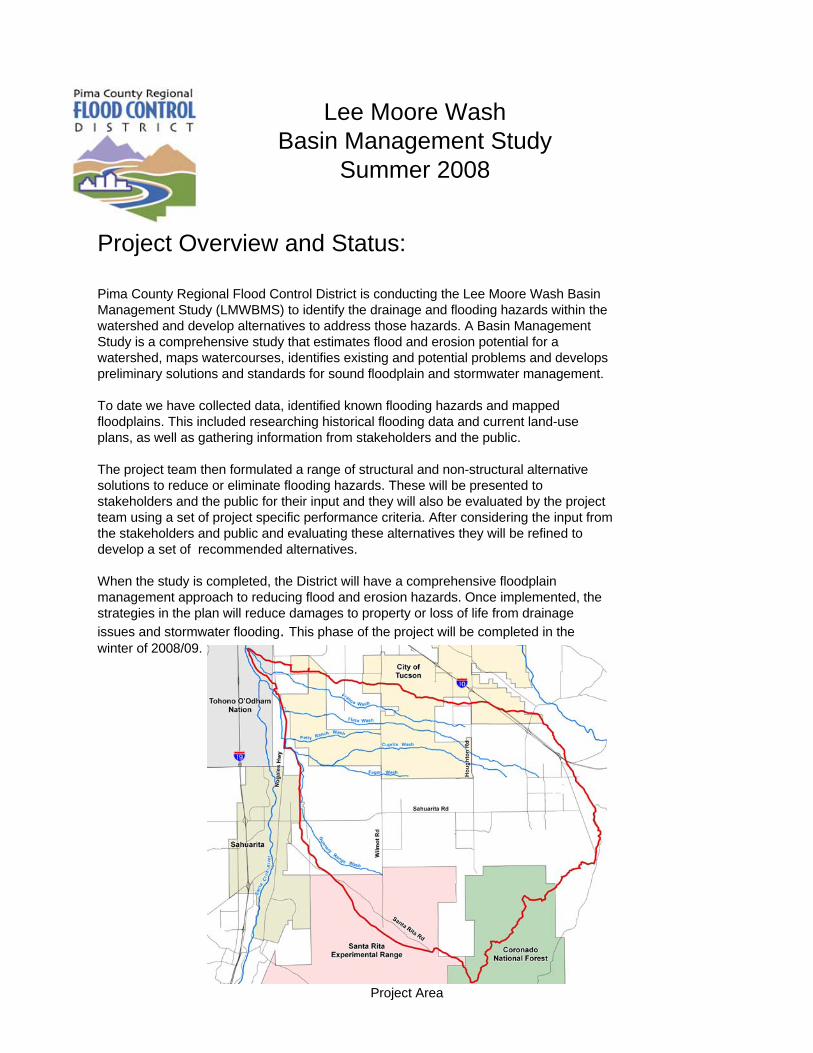
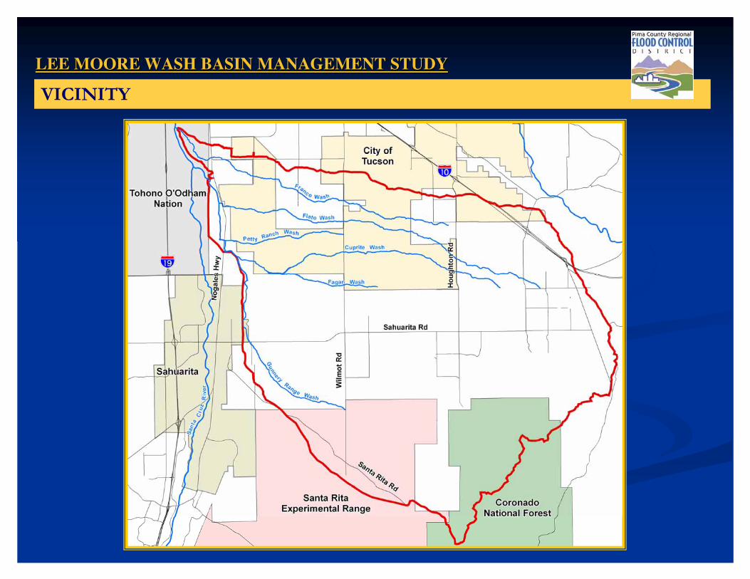
Project Area

Project Area:The total project watershed is approximately 213 square miles, including parts of unincorporated Pima County, City of Tucson, Town of Sahuarita, Coronado National Forest, and Arizona State Trust Lands.
Planning Areas:In order to effectively manage the large study area, the LMWBMS study area is divided into four planning areas. The planning areas are defined by the current and proposed land uses, the types of flooding problems in the area, sub-watershed boundaries, and the 100-year floodplain limits. The planning areas are described below.Area-Wide Lee Moore Wash WatershedThe Lee Moore Wash watershed is situated in the southeast portion of the Tucson basin, with headwaters situated in the Santa Rita Mountains. The watershed is comprised of eight sub-watersheds characterizing the three general planning areas described below. Drainage patterns trend west-northwesterly to the Lee Moore Wash channel situated along the western extent of the study area. The Santa Cruz River floodplain borders the western boundary of the Lee Moore Wash watershed.
Franco/Flato/Summit AreaThe Franco, Flato and Summit watersheds represent the northernmost portion of the project, and generally exhibit the most topographically defined watershed area, allowing floodplain mapping using one-dimensional HEC-HMS and HEC-RAS hydrologic/hydraulic modeling techniques. This area encompasses the most developed watersheds within the project, with additional development planned in the near future.
Cuprite/Fagan/Petty Ranch AreaThe Cuprite, Fagan and Petty Ranch watersheds represent the central portion of the project, and are characterized predominantly by poorly defined watershed boundaries and distributary flow networks. Thus, hydrologic and hydraulic evaluations for floodplain mapping within this area was performed using two-dimensional FLO-2D modeling techniques. There is existing development within the central portion of the area, generally situated along the Sahuarita Road corridor.
Sycamore Canyon and Gunnery Range AreaThe Sycamore Canyon and Gunnery Range watersheds represent the southernmost portion of the project, and similar to the Cuprite/Fagan/Petty Ranch area, are characterized predominantly by poorly defined watershed boundaries requiring the use of the two-dimensional FLO-2D modeling for floodplain mapping. This area also displays some limited existing development, again centered along the Sahuarita Road corridor. A significant portion of the upstream area is comprised of the Santa Rita Experimental Range, Coronado National Forest, and/or other federal holdings. Much of the downstream area is situated within the Town of Sahuarita Air Force Range planning area.

Alternatives:Alternatives were developed to mitigate flooding hazards that are impacting current residents and future land use plans. The flood mitigation alternatives are organized into four general categories, which are Non-Structural, Structural,LMWBMS Guidelines, and No-Action Alternatives.
The proposed alternatives will consider both environmental resources and multi-use opportunities. The alternatives considered and to be evaluated include: flow corridor preservation, rules of development, channels, roadway realignment, culverts, detention basins, floodplain land acquisition, LMWBMS guidelines, floodplain delineation and no-action.
Various alignments are being considered for the structural alternatives. All alternatives are being evaluated by a multi-disciplinary team of professionals including representatives from the City of Tucson, Town of Sahuarita and the State Land Department.
Alternatives evaluations are being developed using objective performance criteria for the five categories of:Public Safety and Flood Hazard Mitigation Environmental ResourcesPlanning/InfrastructureSustainability Implementation
After the alternatives evaluations are completed, costs will be applied and the Recommended Alternatives will be developed.
Flooding and Erosion Issues:
Franco/Flato/Summit AreaOld Vail Connection access – Franco Wash crossingFlooding on Franco Wash – Country Club Road to Nogales HighwayFloodplain encroachments/obstructions – walls, fill, debrisLack of all-weather roadway accessDiversion structures along main branch of Flato WashLack of drainage system in the Summit areaDrainage complaints in developed areas
Cuprite/Fagan/Petty Ranch AreaLack of all-weather roadway accessShallow sheet floodingDrainage complaints in the Corona de Tucson areaDrainage complaints in the area east of
Wilmot Road/Sahuarita Road intersection
Sycamore Canyon and Gunnery Range AreaLack of all-weather roadway accessShallow sheet floodingDrainage complaints in the area east of Country Club Road/Sahuarita Road intersectionDrainage complaints in the area east of Wilmot Road/Sahuarita Road intersection
Area-Wide Lee Moore Wash WatershedUndersized culvert crossingsRoadway floodingStock pond failure/downstream flooding potentialFloodplain encroachments/obstructions – walls, fill, debrisLocalized erosion/sedimentation – driveways, road crossings, head cutting, channel migration, culvertsDrainage complaints
Mapped Floodplains

Your Input:
For more information contact:Bill Zimmerman, Division Manager
Pima County Regional Flood Control District520.243.1800
This project is strongly supported by the Pima County Board of Supervisors, the City of Tucson and the Town of Sahuarita.
It is important that the stakeholders stay involved in the process as they have valuable knowledge and multiple responsibilities within the watershed that could significantly influence the project’s success. We invite and encourage your support of this study. Please stay involved by visiting our website, talking to the study team and attending future stakeholder meetings.
Next Steps:The LMWBMS team will complete the alternatives evaluation, which will include descriptions, cost estimates, opportunities, and constraints. Each alternative will be evaluated using the performance criteria developed by the study team. Based on the outcome of the evaluation, the study team will conduct a workshop to develop the recommended alternatives, incorporating comments received from the stakeholder/public meetings.Once the recommended alternatives have been chosen, the Lee Moore Wash study team will further develop the recommended plan. These efforts will include preliminary drawings of the elements of the plan, cost estimates for plan implementation, conceptual drawings of the structural alternatives and proposed multi-use opportunities associated with each alternative. The District will then schedule the final public meetings to present the recommended plan.
Multi-use opportunity examples
���������������� ��� ����� ������
����������������������������������������������� ������� ��
!�"����#�$%&�'(()!�"����#�$%&�'(()

���������������� ��� ����� ���������������������� ��� ����� ������
� � �����*��� +� ����� ��,����+�� ,��-�*���������� �.�+�� ��/� ����� +� ���0��!�������� +� *������� �����������!���"�*�
�� � �����*��� +� �����*��� +
�� ����� ��,����+������ ��,����+�
�� ,��-�*���������,��-�*���������
�� �.�+�� ��/� ����� +�.�+�� ��/� ����� +
�� ���0��!�������� +���0��!�������� +
�� *������*������
�� �����������!���"�*������������!���"�*�
��� ��
���������������� ��� ����� ���������������������� ��� ����� ������
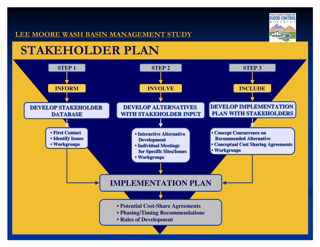
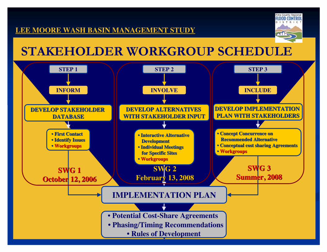
��1�������,�� STEP 1
INFORM
DEVELOP STAKEHOLDER DEVELOP STAKEHOLDER DATABASEDATABASE
•• First ContactFirst Contact•• Identify IssuesIdentify Issues•• WorkgroupsWorkgroups
IMPLEMENTATION PLAN
• Potential Cost-Share Agreements • Phasing/Timing Recommendations• Rules of Development
STEP 2
INVOLVE
DEVELOP ALTERNATIVES DEVELOP ALTERNATIVES WITH STAKEHOLDER INPUTWITH STAKEHOLDER INPUT
•• Interactive Alternative Interactive Alternative DevelopmentDevelopment
•• Individual Meetings Individual Meetings for Specific Sites/Issuesfor Specific Sites/Issues
•• WorkgroupsWorkgroups
STEP 3
INCLUDE
DEVELOP IMPLEMENTATION DEVELOP IMPLEMENTATION PLAN WITH STAKEHOLDERSPLAN WITH STAKEHOLDERS
•• Concept Concurrence on Concept Concurrence on Recommended AlternativeRecommended Alternative
•• Conceptual Cost Sharing Agreements Conceptual Cost Sharing Agreements •• WorkgroupsWorkgroups
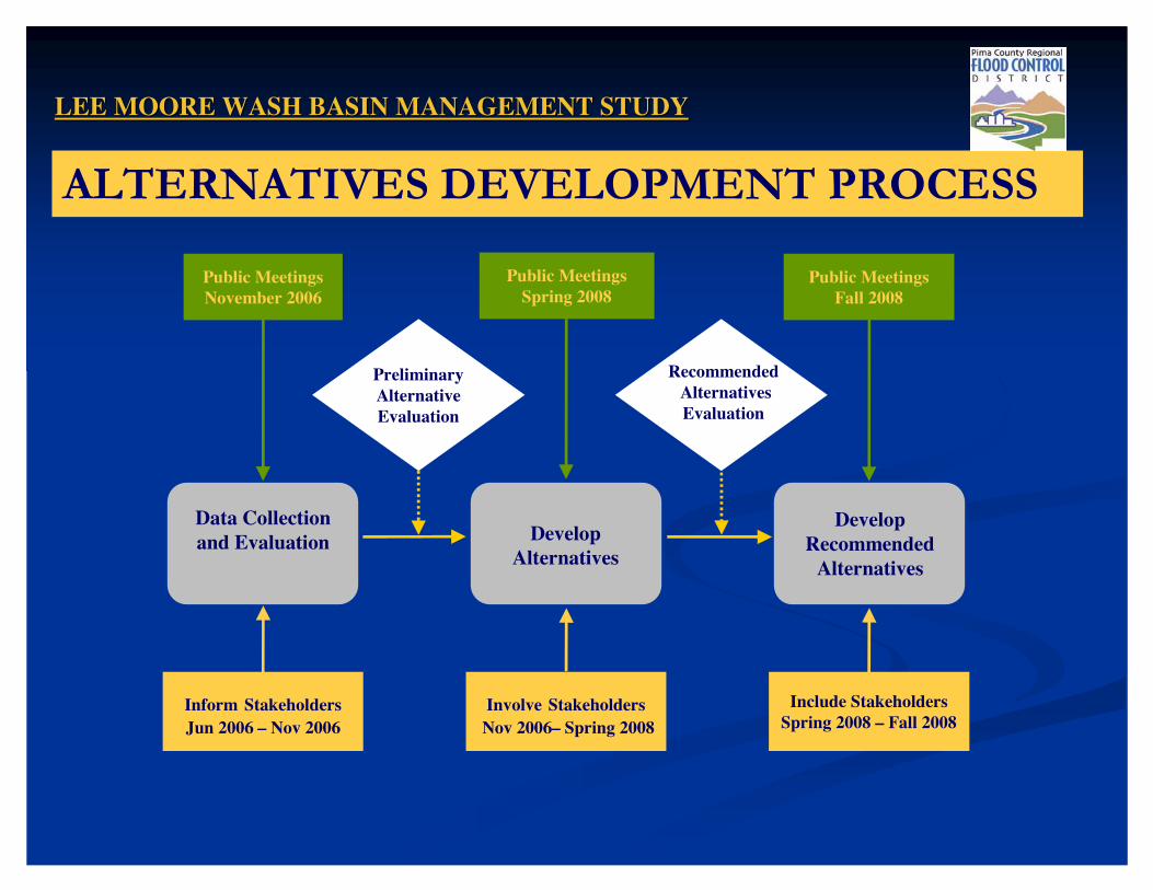
LEE MOORE WASH BASIN MANAGEMENT STUDYLEE MOORE WASH BASIN MANAGEMENT STUDY
����� ���2����2���,�� ��,��/�
Data Collectionand Evaluation Develop
Alternatives
Inform StakeholdersJun 2006 – Nov 2006
Public Meetings November 2006
Public MeetingsSpring 2008
Public MeetingsFall 2008
Involve StakeholdersNov 2006– Spring 2008
Include StakeholdersSpring 2008 – Fall 2008
Preliminary Alternative Evaluation
RecommendedAlternatives Evaluation
Develop Recommended
Alternatives
LEE MOORE WASH BASIN MANAGEMENT STUDYLEE MOORE WASH BASIN MANAGEMENT STUDY
2�/� ���

���������������� ��� ����� ���������������������� ��� ����� ������
� ,��-�*����+*������ � �����/����*��� 3�.�+�� ��/� ����� +��4�������
� ,�"��*3������������ 4��4�5� �� �55�����������#� #������#6�#������*+� !�������� ����� ����� +�� ����� ���4�+���4����5� �
�� ,��-�*����+*������ ,��-�*����+*������
�� �����/����*��� 3�.�+�� �������/����*��� 3�.�+�� ��/� ����� +��4������� /� ����� +��4�������
�� ,�"��*3������������ 4��4�5� �,�"��*3������������ 4��4�5� �
�� �55�����������#�55�����������#
�� #������#6�#������*+#������#6�#������*+
�� !�������� ����� ����� +�!�������� ����� ����� +�
�� ����� ���4�+���4����5� ������ ���4�+���4����5� �
,��7�/���,����

LEE MOORE WASH BASIN MANAGEMENT STUDYLEE MOORE WASH BASIN MANAGEMENT STUDY
�����/����/��� 3�8��� ��/� ����� ��2�������
TASKSTASKS•• Data CollectionData Collection•• Existing Condition EvaluationExisting Condition Evaluation•• Public/ Stakeholder InvolvementPublic/ Stakeholder InvolvementOUTCOMESOUTCOMES•• Problem IdentificationProblem Identification•• Drainage Facility InventoryDrainage Facility Inventory
TIMELINETIMELINE•• June 2006 June 2006 –– November 2007November 2007

LEE MOORE WASH BASIN MANAGEMENT STUDYLEE MOORE WASH BASIN MANAGEMENT STUDY
�����/����/��� 3�8��� ��/� ����� ��2�������
OUTCOMESOUTCOMES�� �.�+�� ���� ���+�+�.�+�� ���� ���+�+�� ,����+����� ���+�+,����+����� ���+�+�� � 4��� 5� ����#�� +���4���� �+� 4��� 5� ����#�� +���4���� �+�� ����� ������ +�������� ����� ������ +�������� �� �.�+�� ������ ����/� ����� +�.�+�� ������ ����/� ����� +�� ���5�����*����� ����5�����*����� ��� #���������##���������#
LEE MOORE WASH BASIN MANAGEMENT STUDYLEE MOORE WASH BASIN MANAGEMENT STUDY
�����/����/��� 3�8��� ��/� ����� ��2�������
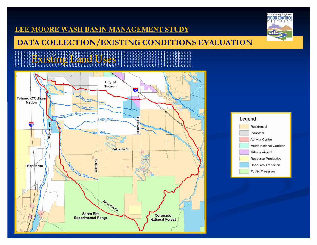
Existing Land UsesExisting Land Uses

LEE MOORE WASH BASIN MANAGEMENT STUDYLEE MOORE WASH BASIN MANAGEMENT STUDY
�����/����/��� 3�8��� ��/� ����� ��2�������
Proposed Land UsesProposed Land Uses
LEE MOORE WASH BASIN MANAGEMENT STUDYLEE MOORE WASH BASIN MANAGEMENT STUDY
�����/����/��� 3�8��� ��/� ����� ��2�������
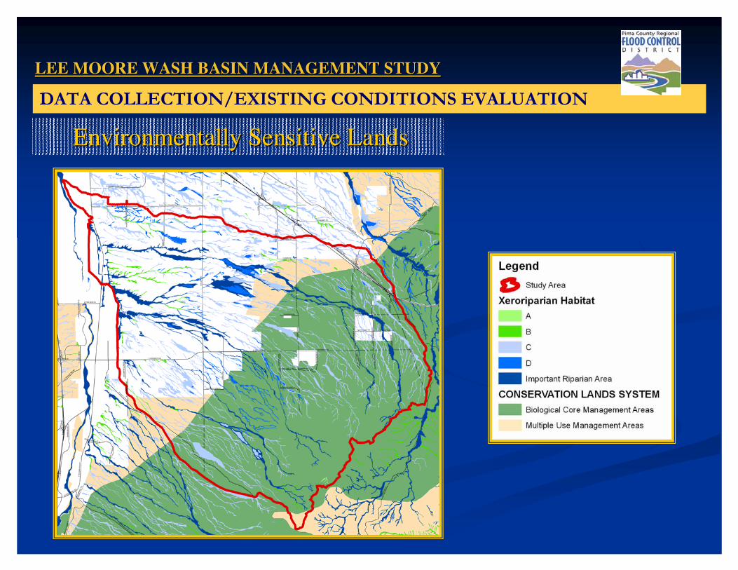
Environmentally Sensitive LandsEnvironmentally Sensitive Lands

LEE MOORE WASH BASIN MANAGEMENT STUDYLEE MOORE WASH BASIN MANAGEMENT STUDY
�����/����/��� 3�8��� ��/� ����� ��2�������
Regional TransportationRegional Transportation

LEE MOORE WASH BASIN MANAGEMENT STUDYLEE MOORE WASH BASIN MANAGEMENT STUDY
�����/����/��� 3�8��� ��/� ����� ��2�������
Existing Drainage ConditionsExisting Drainage Conditions
LEE MOORE WASH BASIN MANAGEMENT STUDYLEE MOORE WASH BASIN MANAGEMENT STUDY
�����/����/��� 3�8��� ��/� ����� ��2�������
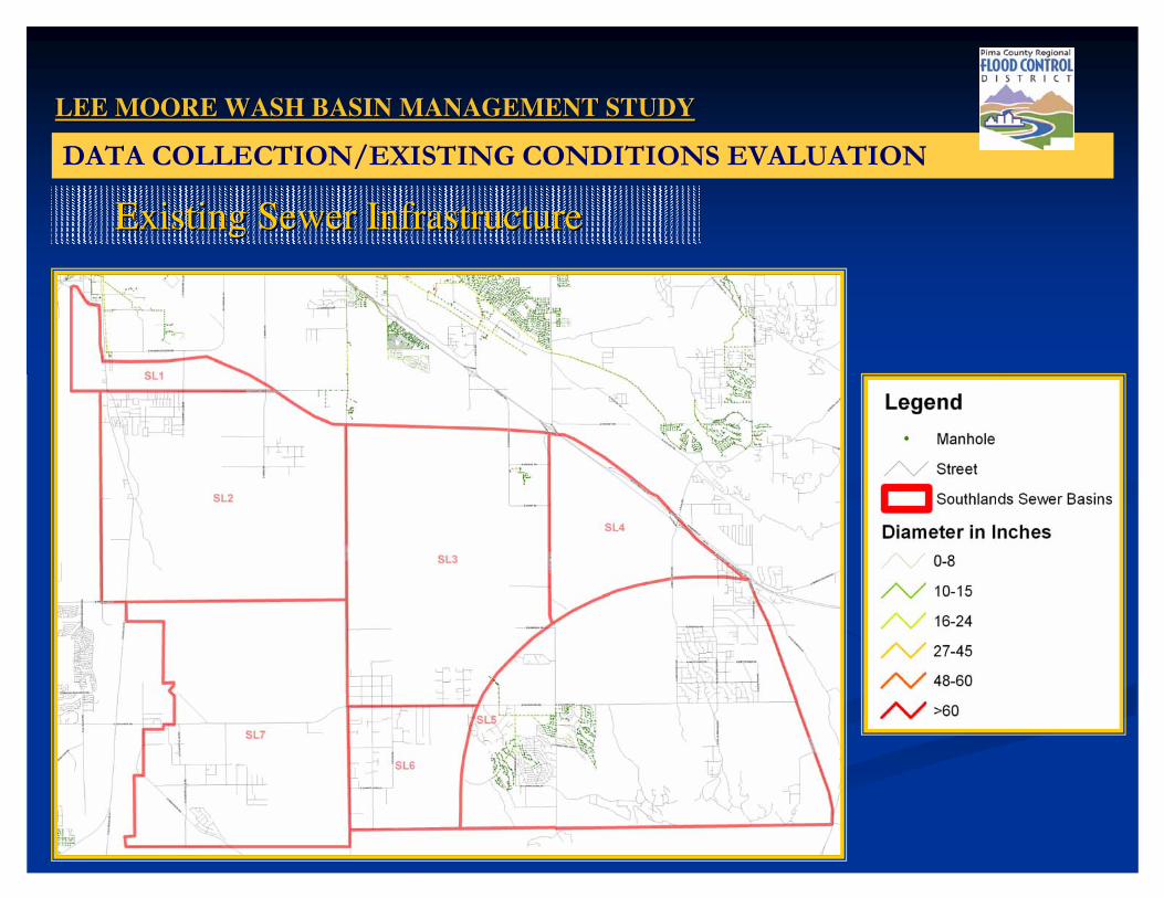
Existing Sewer InfrastructureExisting Sewer Infrastructure
LEE MOORE WASH BASIN MANAGEMENT STUDYLEE MOORE WASH BASIN MANAGEMENT STUDY
�����/����/��� 3�8��� ��/� ����� ��2�������
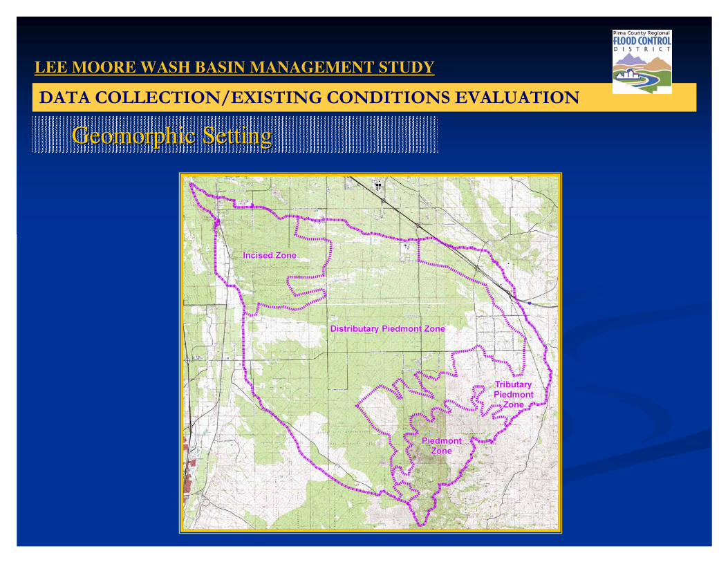
Geomorphic SettingGeomorphic Setting

LEE MOORE WASH BASIN MANAGEMENT STUDYLEE MOORE WASH BASIN MANAGEMENT STUDY
�����/����/��� 3�8��� ��/� ����� ��2�������
HydrogeologyHydrogeology

LEE MOORE WASH BASIN MANAGEMENT STUDYLEE MOORE WASH BASIN MANAGEMENT STUDY
!����,��� ����� �����
DATA
• 2005/2002 PAG• Orthophotos• Elevation Data• USGSHYDROLOGY
• HEC-HMS• FLO-2D
HYDRAULICS
• HEC-RAS• FLO-2D
GEOMORPHIC ANALYSIS
MAPPING
LEE MOORE WASH BASIN MANAGEMENT STUDYLEE MOORE WASH BASIN MANAGEMENT STUDY
,������ ��������� ���2�
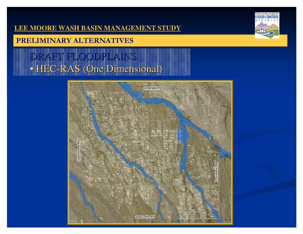
DRAFT FLOODPLAINSDRAFT FLOODPLAINS•• HECHEC--RAS (One Dimensional)RAS (One Dimensional)

LEE MOORE WASH BASIN MANAGEMENT STUDYLEE MOORE WASH BASIN MANAGEMENT STUDY
,������ ��������� ���2�
DRAFT FLOODPLAINSDRAFT FLOODPLAINS•• FLOFLO--2D (Two Dimensional)2D (Two Dimensional)

LEE MOORE WASH BASIN MANAGEMENT STUDYLEE MOORE WASH BASIN MANAGEMENT STUDY
,������ ��������� ���2�
DRAFT FLOODPLAINSDRAFT FLOODPLAINS•• FLOFLO--2D (Two Dimensional)2D (Two Dimensional)

LEE MOORE WASH BASIN MANAGEMENT STUDYLEE MOORE WASH BASIN MANAGEMENT STUDY
!��������19������ ���2��� ����
TASKSTASKS•• Existing Constraints MapExisting Constraints Map•• Alternatives Concept DesignAlternatives Concept Design•• Feasibility AnalysesFeasibility Analyses•• Cost AnalysesCost Analyses•• Public/ Stakeholder InvolvementPublic/ Stakeholder Involvement
OUTCOMEOUTCOME•• Evaluation CriteriaEvaluation Criteria•• Recommended Alternatives (Feasibility Level) Recommended Alternatives (Feasibility Level) •• Rules of DevelopmentRules of Development
TIMELINETIMELINE•• Spring 2008 Spring 2008 -- December 2008December 2008
LEE MOORE WASH BASIN MANAGEMENT STUDYLEE MOORE WASH BASIN MANAGEMENT STUDY
!��������19���,���� �����
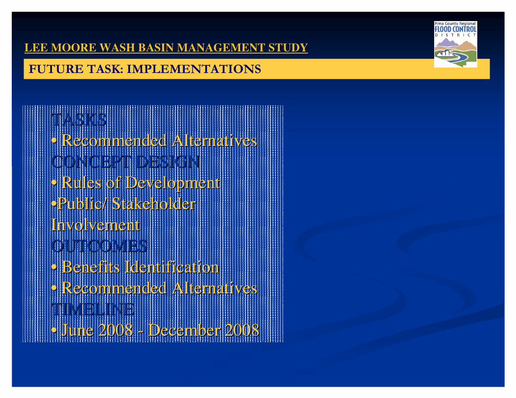
TASKSTASKS•• Recommended Alternatives Recommended Alternatives CONCEPT DESIGNCONCEPT DESIGN•• Rules of Development Rules of Development ••Public/ Stakeholder Public/ Stakeholder InvolvementInvolvementOUTCOMESOUTCOMES•• Benefits IdentificationBenefits Identification•• Recommended Alternatives Recommended Alternatives TIMELINETIMELINE•• June 2008 June 2008 -- December 2008December 2008

LEE MOORE WASH BASIN MANAGEMENT STUDYLEE MOORE WASH BASIN MANAGEMENT STUDY
/�����
• Data Collection/Existing Conditions
• Hydrologic Analysis
• Hydraulic Analysis
• Geomorphic Analysis
• Alternative Identification
• Rules of Development
• Final Deliverables
June – April 2007
September 2006 – November 2007
September 2006 – February 2008
September 2006 – February 2008
November 2007 – June 2008
November 2007 – August 2008
November 2008

LEE MOORE WASH BASIN MANAGEMENT STUDYLEE MOORE WASH BASIN MANAGEMENT STUDY
������!���2���,�� �
Technical and Regulatory Guidelines Specific to the Watershed will be Developed.
Examples Could Include:
• Erosion Hazard Setbacks
• Disturbance Envelope
• Wall & Fences
• Inspection and Maintenance of Impoundment Facilities
• Culvert and Energy Dissipation
LEE MOORE WASH BASIN MANAGEMENT STUDYLEE MOORE WASH BASIN MANAGEMENT STUDY
��1����������1����,�/�����STEP 1
INFORM
DEVELOP STAKEHOLDER DEVELOP STAKEHOLDER DATABASEDATABASE
•• First ContactFirst Contact•• Identify IssuesIdentify Issues•• WorkgroupsWorkgroups
IMPLEMENTATION PLAN
: Potential Cost-Share Agreements • Phasing/Timing Recommendations
• Rules of Development
STEP 2
INVOLVE
DEVELOP ALTERNATIVES DEVELOP ALTERNATIVES WITH STAKEHOLDER INPUTWITH STAKEHOLDER INPUT
•• Interactive Alternative Interactive Alternative DevelopmentDevelopment
•• Individual Meetings Individual Meetings for Specific Sitesfor Specific Sites
•• WorkgroupsWorkgroups
STEP 3
INCLUDE
DEVELOP IMPLEMENTATION DEVELOP IMPLEMENTATION PLAN WITH STAKEHOLDERSPLAN WITH STAKEHOLDERS
•• Concept Concurrence on Concept Concurrence on Recommended AlternativeRecommended Alternative
•• Conceptual cost sharing Agreements Conceptual cost sharing Agreements •• WorkgroupsWorkgroups
SWG 1SWG 1October 12, 2006October 12, 2006
SWG 2SWG 2February 13, 2008February 13, 2008
SWG 3SWG 3Summer, 2008Summer, 2008

����������������
����� ��������� ����