lee moore wash basin management study volume 3 ... · lee moore wash basin management study volume...
TRANSCRIPT

Lee Moore Wash Basin Management Study Volume 3 Implementation Plan Adopted by Pima County Regional Flood Control District Board of Directors June 1st, 2010 Adopted by City of Tucson Mayor and Council October 19th, 2010 Adopted by Town of Sahuarita Mayor and Council December 13th,2010 Stantec Project No.: 185120071

LEE MOORE WASH BASIN MANAGEMENT STUDY IMPLEMENTATION PLAN
Table of Contents
EXECUTIVE SUMMARY ............................................................................................................ 1
STAKEHOLDER INVOLVEMENT PROGRAM APPROACH .................................................. 3
Phase 1 ........................................................................................................................................ 3
Phase 2 ........................................................................................................................................ 3
Phase 3 ........................................................................................................................................ 4
IMPLEMENTATION SUMMARY ............................................................................................... 4
RECOMMENDED ALTERNATIVE OPPORTUNITIES AND CONSTRAINTS (Existing
Conditions) ...................................................................................................................................... 6
LMWBMS Area-Wide Problem Area ........................................................................................ 6
Franco/Flato/Summit Area Problem Area .................................................................................. 6
Cuprite/Fagan/Petty Ranch Area Problem Area ......................................................................... 7
Sycamore Canyon & Gunnery Range Area Problem Area ......................................................... 7
LMWBMS Area-Wide Recommended Alternative.................................................................... 8
Franco/Flato/Summit Area Recommended Alternative ............................................................ 10
Cuprite/Fagan/Petty Ranch Area Recommended Alternative .................................................. 17
Sycamore Canyon & Gunnery Range Area Recommended Alternative .................................. 19
RECOMMENDED ALTERNATIVE OPPORTUNITIES AND CONSTRAINTS (Future
Conditions) .................................................................................................................................... 23
LMWBMS Area-Wide Problem Area ...................................................................................... 23
Franco/Flato/Summit Area Problem Area ................................................................................ 23
Cuprite/Fagan/Petty Ranch Area Problem Area ....................................................................... 23
Sycamore Canyon & Gunnery Range Area Problem Area ....................................................... 24
LMWBMS Area-Wide Recommended Alternative.................................................................. 24
Franco/Flato/Summit Area Recommended Alternative ............................................................ 25
Cuprite/Fagan/Petty Ranch Area Recommended Alternative .................................................. 26
Sycamore Canyon & Gunnery Range Area Recommended Alternative .................................. 28
LEE MOORE WASH BASIN MANAGEMENT STUDY IMPLEMENTATION PLAN
Tables
A Recommended Alternatives Summary – Existing Conditions
B Recommended Alternatives Summary – Future Conditions
Appendices
A Pima County Flood Control District Board of Directors Resolution
B City of Tucson Resolution
C Town of Sahuarita Resolution
D Arizona State Land Department Letter of Concurrence
E Development Criteria
F Stakeholder Involvement Flow Chart
G Stakeholder Database

LEE MOORE WASH BASIN MANAGEMENT STUDY IMPLEMENTATION PLAN
Page 1 of 27
EXECUTIVE SUMMARY
The Stakeholder Involvement program for this project was designed by C.L. Williams
Consulting, Inc. (CLW), and completed with the goal of maximizing implementation
opportunities for the Recommended Alternative(s) of the Lee Moore Wash Basin Management
Study (LMWBMS). The results of the Stakeholder Involvement and Implementation Strategy are
summarized in this Implementation Plan which is Volume 3 of 3 of the LMWBMS. The
Implementation Plan details the Recommended Alternative(s) by location, capital improvement
costs, potential cost sharing partner, participation interest, potential mechanism for participation
and preliminary timeline whenever possible. The Implementation Plan has been developed
iteratively and in cooperation with the affected stakeholders. It does not represent a binding
legal agreement on any partners, but does provide a solid summary of implementation efforts to
date, as well as a roadmap for the Pima County Regional Flood Control District implementation
efforts since the LMWBMS has been adopted by the Board of Directors, the City of Tucson and
the Town of Sahuarita (see Appendices A, B, C for copies of the signed Resolutions). The
Arizona State Land Department (ASLD) which owns approximately 48% of the land in the Basin
was involved throughout the LMWBMS and has provided a Letter of Concurrence for the Study
(see Appendix D). Several of the Recommended Alternatives are connected with other agency
programs. The result is that often their schedule or funding will drive the implementation
timeline. Recognition of this fact by the District and planning for this in future follow through
efforts will allow for cost effective and efficient construction completion. If the coordination is
not continued after LMWBMS completion, it is possible that other agencies will move ahead
with their projects and not include Recommended Alternatives drainage improvements.
LEE MOORE WASH BASIN MANAGEMENT STUDY IMPLEMENTATION PLAN
Page 2 of 27
The Recommended Alternatives for this project are comprised of structural and non-structural
solutions at various locations. These locations are distributed throughout the project area and
include construction and non-construction activities that will ultimately be funded in one of three
ways:
1) Solely funded by the District.
2) Funded solely or in partnership among private and/or public agencies including the
District.
3) Funded solely or in partnership among private and/or public agencies not including the
District.
The Recommended Alternatives were developed after extensive technical review of the drainage,
infrastructure and land use conditions in the project area. Significant effort was also put forth by
the project team to involve the general public, as well as public and private sector stakeholders,
in development of the Recommended Alternatives. Included within Volume 2 of 3 of the
LMWBMS report is documentation of the public and stakeholder activities and responses.

LEE MOORE WASH BASIN MANAGEMENT STUDY IMPLEMENTATION PLAN
Page 3 of 27
STAKEHOLDER INVOLVEMENT PROGRAM APPROACH
The Stakeholder Involvement program for this project was designed and completed with the goal
of maximizing implementation opportunities for the Recommended Alternatives of the Lee
Moore Wash Basin Management Plan (LMWBMS). To achieve this end, the “3-I’s” method
(Inform, Involve and Include) to interact with stakeholders was utilized. Simply put, the 3-I’s
method of Stakeholder Involvement is to utilize a 3-Phase approach as identified in the
accompanying Stakeholder Flowchart (see Appendix F) & Implementation Plan Summary
below:
Phase 1
Inform the stakeholders of the project at the early stages to obtain any useful
knowledge they may have from a data collection standpoint, as well as to
receive any initial input they may have regarding scope of work or process.
This was accomplished through facilitated workgroups of stakeholders with
similar mandates, jurisdictions, and interests (i.e. private and public sector).
Several individual meetings were also held for those stakeholders with a
unique interest (i.e. Diamond Ventures, etc.). Stakeholders and their
preliminary concerns/interests were identified and compiled into a spreadsheet
which was used as the baseline database for the rest of the stakeholder
involvement program. The Stakeholder database (see Appendix G) is
included herein for completeness.
Phase 2
Involve the stakeholders throughout the course of the LMWBMS so that they
stay informed and interested in the project. This also allowed for them to see
how and the reasons why, or why not, their input would be included in the
development of alternatives. This was accomplished through the use of

LEE MOORE WASH BASIN MANAGEMENT STUDY IMPLEMENTATION PLAN
Page 4 of 27
facilitated workgroups as well as individual meetings. An added benefit of
maintaining contact throughoout the course of the project is that new staff
members from the agencies were educated prior to being shown the end
product. Their involvement was instrumental in developing the matrices used
for all of the alternatives evaluated at each site as documented in Volume 1 of
the LMWBMS .
Phase 3
Include the stakeholders in the process of selection of the Recommended
Alternative(s). This effort included information exchange and discussion of:
a) costs of capital improvements
b) costs of maintenance
c) conceptual cost sharing agreements for capital improvements
d) conceptual agreements on maintenance responsibilities
e) conceptual construction timelines coordinated with other agencies’
projects and budgets.
This was accomplished using a combination of workgroups and individual
meetings because of the iterative nature of these negotiations. Stakeholders’
input was considered in the conceptual design plans and cost estimates
contained in Volume 1 of the LMWBMS .
IMPLEMENTATION SUMMARY
The results of the Stakeholder Involvement and Implementation Strategy are summarized in the
following Implementation Summary. The Summary details the Recommended Alternatives by
location, capital improvement costs, potential cost sharing partner, participation interest,
mechanism for participation and preliminary timeline. The Implementation Summary was
LEE MOORE WASH BASIN MANAGEMENT STUDY IMPLEMENTATION PLAN
Page 5 of 27
developed iteratively and in cooperation with the affected stakeholders. It does not represent a
binding legal agreement on any partners, but does provide a solid summary of implementation
strategies to date and a roadmap for the Pima County Regional Flood Control District (District)
implementation efforts since it was adopted by the Board of Directors on June 1st, 2010. Many
of the Recommended Alternative(s) are connected with other agency programs. The result is
that often their schedule or funding will drive the construction timeline. Recognition of this fact
by the District and planning for this in future follow through efforts will allow for cost effective
and efficient construction completion. If the coordination is not continued after LMWBMS
completion, it is possible that other agencies will move ahead with their projects and not include
Recommended Alternatives drainage and flood mitigation improvements.
The Recommended Alternatives for this project are comprised of structural and non-structural
solutions at various locations. These locations are distributed throughout the project area and
include construction and non-construction activities that will ultimately be funded in one of three
ways:
1) Solely funded by the District.
2) Funded solely or in partnership among private and/or public agencies including the
District.
3) Funded solely or in partnership among private and/or public agencies not including the
District.
The Recommended Alternatives were developed after extensive technical review of the drainage,
infrastructure and land use conditions in the project area. Significant effort was also put forth by
the project team to involve the general public, as well as public and private sector stakeholders,
in development of the Recommended Alternatives. Included within Volume 2 of 3 of the
LMWBMS Report is documentation of the public and stakeholder activities and responses. The
stakeholder effort was designed and carried out so as to maximize development of
Recommended Alternative(s) that could be implemented as efficiently and cost-effectively as
LEE MOORE WASH BASIN MANAGEMENT STUDY IMPLEMENTATION PLAN
Page 6 of 27
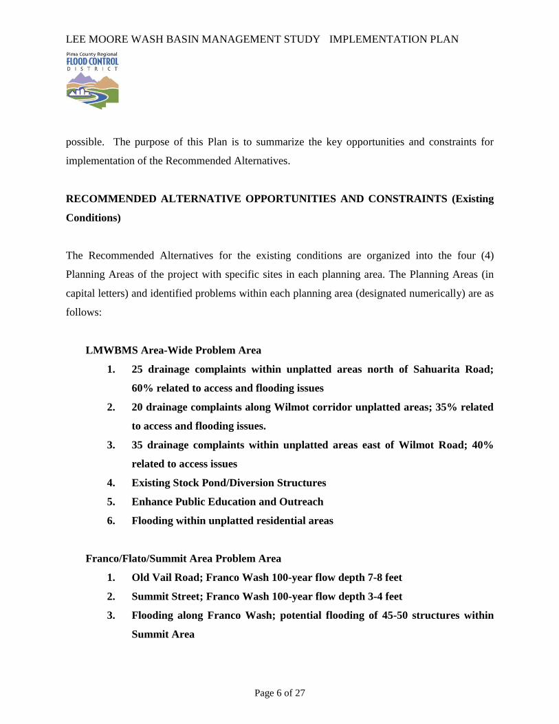
possible. The purpose of this Plan is to summarize the key opportunities and constraints for
implementation of the Recommended Alternatives.
RECOMMENDED ALTERNATIVE OPPORTUNITIES AND CONSTRAINTS (Existing
Conditions)
The Recommended Alternatives for the existing conditions are organized into the four (4)
Planning Areas of the project with specific sites in each planning area. The Planning Areas (in
capital letters) and identified problems within each planning area (designated numerically) are as
follows:
LMWBMS Area-Wide Problem Area
1. 25 drainage complaints within unplatted areas north of Sahuarita Road;
60% related to access and flooding issues
2. 20 drainage complaints along Wilmot corridor unplatted areas; 35% related
to access and flooding issues.
3. 35 drainage complaints within unplatted areas east of Wilmot Road; 40%
related to access issues
4. Existing Stock Pond/Diversion Structures
5. Enhance Public Education and Outreach
6. Flooding within unplatted residential areas
Franco/Flato/Summit Area Problem Area
1. Old Vail Road; Franco Wash 100-year flow depth 7-8 feet
2. Summit Street; Franco Wash 100-year flow depth 3-4 feet
3. Flooding along Franco Wash; potential flooding of 45-50 structures within
Summit Area

LEE MOORE WASH BASIN MANAGEMENT STUDY IMPLEMENTATION PLAN
Page 7 of 27
4. Flooding along Summit Wash; potential flooding of 30-35 structures from
County Club to Nogales Highway
5. Additional flooding along Franco Tributary south of Old Vail Road
6. Flooding along Flato at Old Nogales Highway
7. Maintenance of Lee Moore Channel Bank Protection/Bank Erosion
8. Franco Wash at Houghton Road: +/-1000 feet, depth >1 foot
9. Flato Wash at Houghton Road--depth>1 foot
10. Stock ponds upstream of Wentworth/I-10 interchange--potential flooding at
interchange with failure
11. Stock Ponds/diversions along Flato main corridor--potential diversion of flow
north into Franco watershed
12. New Tucson all-weather access issues at several crossings; undersized
culverts at several crossings
13. Impacts of stock ponds/diversion structures south of Sahuarita Road and
New Tucson area
Cuprite/Fagan/Petty Ranch Area Problem Area
1. FICO Channel lacks capacity to convey flow north, breakout/flooding to west
2. Sahuarita Road-all-weather access limited from east near Wentworth Road
to Houghton
3. Approximately 2 miles of Sahuarita Road - Houghton Road to Rita Road
alignment
4. Houghton Road-all-weather access limited from north
5. Houghton, Sahuarita Area--flooding/erosion issues
Sycamore Canyon & Gunnery Range Area Problem Area
1. Sahuarita Road-Rita Road alignment to Nogales Highway
LEE MOORE WASH BASIN MANAGEMENT STUDY IMPLEMENTATION PLAN
Page 8 of 27
2. Undersized/clogged culverts in Sycamore Canyon Estates south of Sahuarita
Road
3. Complaints about integrity of berm along Columbus Boulevard, north of
Dawson, east of Irving
4. Sahuarita, Delgado, Dawson: FICO channel--lack of capacity/sedimentation
causes residential flooding
A brief description of the problem and overview of the Recommended Alternatives for each of
the sites follows.
LMWBMS Area-Wide Recommended Alternative(s)
1. 25 drainage complaints within unplatted areas north of Sahuarita Road;
60% related to access and flooding issues.
o Structural Alternatives:
Floodproofing – Approximately 6 structures in this area could be
protected from flooding by floodproofing.
There was no negative feedback from the public regarding this component of the Recommended
Alternatives.
2. 20 drainage complaints along Wilmot corridor unplatted areas; 35% related
to access and flooding issues.
o Structural Alternatives:
Floodproofing – Approximately 17 structures in this area could be
protected from flooding by floodproofing.

LEE MOORE WASH BASIN MANAGEMENT STUDY IMPLEMENTATION PLAN
Page 9 of 27
There was no negative feedback from the public regarding this component of the Recommended
Alternatives.
3. 35 drainage complaints within unplatted areas east of Wilmot Road; 40%
related to access issues
o Structural Alternatives:
Floodproofing – Approximately 7 structures in this area could be
protected from flooding by floodproofing.
There was no negative feedback from the public regarding this component of the Recommended
Alternatives.
4. Existing Stock Pond/Diversion Structures
o Non-Structural Alternatives:
Ensure maintenance, operation, study and analysis of stock ponds
with future development – There are at least 105 stock ponds in this
area to which this alternative could apply.
There was no negative feedback from the public regarding this component of the Recommended
Alternatives.
5. Enhance Public Education and Outreach
o Non-Structural Alternatives:
Public Education and Outreach – At least annually the District
should disseminate information regarding flood and drainage hazards

LEE MOORE WASH BASIN MANAGEMENT STUDY IMPLEMENTATION PLAN
Page 10 of 27
and LMWBMS implementation status.
There was no negative feedback from the public regarding this component of the Recommended
Alternatives.
6. Flooding within unplatted residential areas in the Sahuarita, Santa Rita and
Dawson areas
Improvement District(s) - The Improvement District(s) allow property
owners to pay to bring their infrastructure up to Standard so that a
public agency can accept maintenance for the infrastructure.
There was no negative feedback from the public regarding this component of the Recommended
Alternatives.
Franco/Flato/Summit Area Recommended Alternative(s)
1. Old Vail Road -- Franco Wash 100-year flow depth 7-8 feet
o Non-Structural Alternatives:
Automatic barricade control – This alternative would require the
installation of two (2) automatic barricades to prevent vehicles from
entering flooded roadway. This could be a temporary alternative that
would be removed once the culvert system was installed.
o Structural Alternatives:
Install culverts – A total of 11- 10’ x 4’ RCB’s were sized within this
area.
LEE MOORE WASH BASIN MANAGEMENT STUDY IMPLEMENTATION PLAN
Page 11 of 27
There was no negative feedback from the public regarding this component of the Recommended
Alternatives. The County will be the lead agencies for implementation of this alternative and
will be responsible for pursuing an Intergovernmental Agreement (IGA) with the County and
City Department of Transportation’s as well as the District.
2. Summit Street -- Franco Wash 100-year flow depth 3-4 feet
o Non-Structural Alternatives:
Automatic barricade control – This alternative would require the
installation of two (2) automatic barricades to prevent vehicles from
entering flooded roadway.
There was no negative feedback from the public regarding this component of the Recommended
Alternatives.
3. Flooding along Franco Wash--potential flooding of 45-50 structures within
Summit Area
o Non-Structural Alternatives:
Public Education and Outreach – While this can’t be quantified, the
effects of the dissemination of information should be measured in
reference to reaching the goals being evaluated.
There was no negative feedback from the public regarding this component of the Recommended
Alternatives.

LEE MOORE WASH BASIN MANAGEMENT STUDY IMPLEMENTATION PLAN
Page 12 of 27
4. Flooding along Summit Wash--potential flooding of 30-35 structures from
County Club to Nogales Highway
o Non-Structural Alternatives:
Public Education and Outreach – While this can’t be quantified, the
effects of the dissemination of information should be measured in
reference to reaching the goals being evaluated.
o Structural Alternatives:
Regional detention basin – The facility evaluated at this location
would require about six (6) acres to meet design criteria.
There was no negative feedback from the public regarding this component of the Recommended
Alternatives.
5. Additional flooding along Franco Tributary south of Old Vail Road
o Non-Structural Alternatives:
Public Education and Outreach – While this can’t be quantified, the
effects of the dissemination of information should be measured in
reference to reaching the goals being evaluated.
o Structural Alternatives:
Regional detention basin – The facility evaluated at this location
would require about 7 acres to meet design criteria.
There was no negative feedback from the public regarding this component of the Recommended
Alternatives.
LEE MOORE WASH BASIN MANAGEMENT STUDY IMPLEMENTATION PLAN
Page 13 of 27
6. Flooding along Flato at Old Nogales Highway
o Non-Structural Alternatives:
Floodprone Land Acquisition Program (FLAP) – Approximately 13
structures can participate in the FLAP in this area.
Public Education and Outreach – While this can’t be quantified, the
effects of the dissemination of information should be measured in
reference to reaching the goals being evaluated.
There was no negative feedback from the public regarding this component of the Recommended
Alternatives.
7. Maintenance of Lee Moore Channel Bank Protection/Bank Erosion
o Structural Alternatives:
Bank stabilization – There is 7,2000 linear feet of bank applicable to
this alternative.
There was no negative feedback from the public regarding this component of the Recommended
Alternatives.
8. Franco Wash at Houghton Road: +/-1000 feet, depth >1 foot
o Non-Structural Alternatives:
Automatic barricade control – This alternative would require the
installation of two (2) automatic barricades to prevent vehicles from
LEE MOORE WASH BASIN MANAGEMENT STUDY IMPLEMENTATION PLAN
Page 14 of 27
entering flooded roadway. This could be a temporary alternative that
would be removed once the culvert system was installed.
o Structural Alternatives:
Install culverts – A total of 7- 10’ x 4’ RCB’s were sized within this
area.
There was no negative feedback from the public regarding this component of the Recommended
Alternatives.
9. Flato Wash at Houghton Road--depth>1 foot
o Non-Structural Alternatives:
Automatic barricade control – This alternative would require the
installation of two (2) automatic barricades to prevent vehicles from
entering flooded roadway.
o Structural Alternatives:
Install culverts – A total of 20- 10’ x 4’ RCB’s at 5 locations were
sized within this area.
There was no negative feedback from the public regarding this component of the Recommended
Alternatives.
10. Stock ponds upstream of Wentworth/I-10 interchange--potential flooding at
interchange with failure
o Non-Structural Alternatives:

LEE MOORE WASH BASIN MANAGEMENT STUDY IMPLEMENTATION PLAN
Page 15 of 27
Ensure maintenance, operation, study and analysis of stock ponds
with future development – There are at least 8 stock ponds in this area
to which this alternative could apply.
o Structural Alternatives:
Utilize stock ponds as regional detention basin(s)
There was no negative feedback from the public regarding this component of the Recommended
Alternatives.
11. Stock Ponds/diversions along Flato main corridor; potential diversion of flow
north into Franco watershed
o Non-Structural Alternatives:
Ensure maintenance, operation, study and analysis of stock ponds
with future development – There are at least 3 stock ponds in this area
to which this alternative could apply.
o Structural Alternatives:
Utilize stock ponds as regional detention basin(s)
There was no negative feedback from the public regarding this component of the Recommended
Alternatives.
12. New Tucson all-weather access issues at several crossings; undersized
culverts at several crossings (Wentworth Road, Andrada Road, Sahuarita
Road and internal road crossings)

LEE MOORE WASH BASIN MANAGEMENT STUDY IMPLEMENTATION PLAN
Page 16 of 27
o Structural Alternatives:
Maintain culverts, upgrade culvert size – There are approximately 15
RCB’s at 2 locations and 24 existing culverts in this area which should
be maintained or upgraded.
Remove access points – There are approximately three (3) access
points applicable to this alternative.
There was no negative feedback from the public regarding this component of the Recommended
Alternatives.
13. Impacts of stock ponds/diversion structures south of Sahuarita Road and
New Tucson area
o Non-Structural Alternatives:
Ensure maintenance, operation, study and analysis of stock ponds
with future development – There are at least 10 stock ponds in this
area to which this alternative could apply.
o Structural Alternatives:
Utilize stock ponds as regional detention basins – There are 10 stock
ponds which could be utilized as regional detention basins.
There was no negative feedback from the public regarding this component of the Recommended
Alternatives.
LEE MOORE WASH BASIN MANAGEMENT STUDY IMPLEMENTATION PLAN
Page 17 of 27
Cuprite/Fagan/Petty Ranch Area Recommended Alternative(s)
1. FICO Channel lacks capacity to convey flow north, breakout/flooding to west
o No Action Alternative: The no action alternative was evaluated and
determined to be the Recommended Alternative for this location
There was no negative feedback from the public regarding this component of the Recommended
Alternatives.
2. Sahuarita Road-all-weather access limited from east near Wentworth Road
to Houghton
o Structural Alternatives:
Collector/conveyance channels
Install Culverts – A total of 8 - 10’ x 4’ RCB’s and 7-48 inch culverts
at 7 locations were sized within this area.
Maintain culverts, upgrade culvert size – There are approximately 4
existing RCB’s and 4-48 inch culverts in this area at 3 locations which
should be maintained or upgraded.
There was no negative feedback from the public regarding this component of the Recommended
Alternatives.
LEE MOORE WASH BASIN MANAGEMENT STUDY IMPLEMENTATION PLAN
Page 18 of 27
3. Approximately 2 miles of Sahuarita Road - Houghton Road to Rita Road
alignment
o Structural Alternatives:
Install Culverts – A total of 27- 10’ x 4’ RCB’s and 2-48 inch culverts
at 8 locations were sized within this area.
Maintain culverts, upgrade culvert size – There are approximately 5
existing culverts in this area which should be maintained or upgraded.
There was no negative feedback from the public regarding this component of the Recommended
Alternatives.
4. Houghton Road-all-weather access limited from north
o Non-Structural Alternatives:
Automatic barricade control – This alternative would require the
installation of 2 automatic barricades to prevent vehicles from entering
flooded roadway.
o Structural Alternatives:
Install Culverts – A total of 33- 10’ x 4’ RCB’s and 21-48 inch
culvertswere sized within this area.
Maintain culverts, upgrade culvert size – There are approximately
eight (8) culverts in this area which should be maintained or upgraded.
There was no negative feedback from the public regarding this component of the Recommended
Alternatives.

LEE MOORE WASH BASIN MANAGEMENT STUDY IMPLEMENTATION PLAN
Page 19 of 27
5. Houghton, Sahuarita Area--flooding/erosion issues
o No Action Alternative: The no action alternative was evaluated and
determined to be the Recommended Alternative for this location.
There was no negative feedback from the public regarding this component of the Recommended
Alternatives.
Sycamore Canyon & Gunnery Range Area Recommended Alternative(s)
1. Sahuarita Road-Rita Road alignment to Nogales Highway
o Structural Alternatives:
Install Culverts – A total of 56- 10’ x 4’ RCB’s and 13-48 inch
culverts at 16 locations were sized within this area.
Maintain culverts, upgrade culvert size – There are approximately 10
existing culverts and 6 RCB’s at 2 locations in this area which should
be maintained or upgraded.
There was no negative feedback from the public regarding this component of the Recommended
Alternatives.
2. Undersized/clogged culverts in Sycamore Canyon Estates south of Sahuarita
Road
o Structural Alternatives:
Maintain culverts, upgrade culvert size – There are approximately 9
LEE MOORE WASH BASIN MANAGEMENT STUDY IMPLEMENTATION PLAN
Page 20 of 27
existing culverts in this area which should be maintained or upgraded.
There was no negative feedback from the public regarding this component of the Recommended
Alternatives.
3. Complaints about integrity of berm along Columbus Boulevard, north of
Dawson, east of Irving
o No Action Alternative: The effects of taking no action should be evaluated for
use as a baseline for any action alternative.
There was no negative feedback from the public regarding this component of the Recommended
Alternatives.
4. Sahuarita, Delgado, Dawson: FICO channel--lack of capacity/sedimentation
causes residential flooding
o Non-Structural Alternatives:
Floodprone Land Acquisition Program (FLAP) – Approximately 141
structures can participate in the FLAP in this area.
o Structural Alternatives:
Regional detention basin – The two facilities evaluated at this location
would require about 154 acres to meet design criteria.
Maintain FICO channel – The subject channel is approximately 7000
feet in length.

LEE MOORE WASH BASIN MANAGEMENT STUDY IMPLEMENTATION PLAN
Page 21 of 27
There was no negative feedback from the public regarding this component of the Recommended
Alternatives.
Summit Area Detailed Drainage Mitigation Study
One of the more intensely developed areas is located within the northwest portion of the Lee
Moore Wash Basin Management Study project area along the Nogales Highway corridor, and is
generally known as the Summit area. This area is situated within the downstream reach of the
Franco Wash, and represents about a two-square mile residential area bounded by Old Vail
Connection Road and the Singing Cactus Lane alignment along the north and south, respectively,
and the Country Club Road alignment and Nogales Highway along the east and west. The
Summit Wash impacts the southern portion of the area. There are a few small platted
subdivisions within the area along with a limited number of County-maintained roads, however,
the vast majority of the development within the area are unplatted subdivisions and lots. Many of
the existing drainage problems reported within the LMWBMS project area are experienced
within the above-referenced unrecorded subdivisions. Given the nature of flooding issues within
the area, a more detailed study of the hydrology and hydraulics was authorized by the PCRFCD
as part of the Lee Moore Wash Basin Management Study in order to evaluate the potential of
developing site-specific drainage solutions. A summary of these efforts is presented in the
following discussion.
The intent of the study was to identify local watersheds that generate peak flows in excess of 100
cfs, the threshold defined by Pima County ordinance for regulatory 100-year floodplains. Since
the Summit area is generally bisected by the Franco Wash from southeast to northwest and the
Summit Wash flows along the southern section, many of the subareas identified with these
efforts were generally small tributary drainage areas flanking either side of these main washes.
Additional areas that discharge east toward Nogales Highway, as well as a larger tributary to
Franco Wash (north of the main Franco flow corridor) comprise the remainder of the watershed
area impacting the Summit residential areas. A summary discussion of the Summit Area study is
provided in the LMWBMS Summary report with detailed Hydrology and Hydraulic data
included.

LEE MOORE WASH BASIN MANAGEMENT STUDY IMPLEMENTATION PLAN
Page 22 of 27
Upon identification of watershed areas that generate peak flows meeting the regulatory
threshold, hydraulic models were developed to determine local regulatory 100-year floodplains
within the Summit area. A map was generated displaying these floodplain areas, as well as the
regional floodplains for Franco Wash and Summit Wash developed with the LMWBMS. Based
on the data developed with this study, along with review of drainage complaints and information
gathered from meetings with residents, potential drainage solutions to specific localized flooding
areas were developed. The primary recommended alternatives involved grading and/or clearing
specific drainage paths in order to provide positive drainage through the identified areas, as well
as maintenance or upgrading of existing drainage culverts.
The proposed conveyance swales would typically be 10-20 feet wide with a depth of about one
foot, and would convey flows associated with the smaller, frequent storms in a westerly,
northwesterly direction through the developed areas. Maps of the proposed location and
alignments of the conceptual improvements were generated, and are included in the Technical
Appendices (Stantec, 2008c) associated with the LMWBMS Hydrologic and Hydraulic Report.
The results of these efforts were presented to residents of the Summit area at public meetings.
However, due to private ownership conflicts, it was determined that implementation of the
proposed alternatives was not feasible at this time.
Specifically, the PCRFCD stipulated to the public at the beginning of the Summit Area Detailed
Drainage Mitigation Study that the District would fund construction and maintenance of the local
drainage improvements, but that residents must dedicate the necessary Right-of-Way or
Easements without cost to the District. After numerous public and individual meetings an
insufficient number residents were willing to dedicate the Right-of-Way or Easements, and
therefore the local drainage improvements identified in the Summit Area Detailed Drainage
Mitigation Study were not included as part of the Existing Condition Recommended Alternatives
for the LMWBMS.

LEE MOORE WASH BASIN MANAGEMENT STUDY IMPLEMENTATION PLAN
Page 23 of 27
RECOMMENDED ALTERNATIVE(S) OPPORTUNITIES AND CONSTRAINTS
(Future Conditions)
The Recommended Alternative(s) are organized into the four Planning Areas of the project with
specific sites in each planning area. The Planning Areas (in capital letters) and problem sites
within each planning area (designated numerically) are as follows:
LMWBMS Area-Wide Problem Area
1. Develop Backbone Drainage Infrastructure
2. Identify and Disclose Flood Hazard Information
Franco/Flato/Summit Area Problem Area
1. 50% of Wilmot Road & Kolb Road alignments are impacted by defined
floodplain areas
2. Country Club Road alignment impacted by main flow corridors of Franco
Wash and Flato Wash
3. Intersection at Dawn Road & I-10 located within floodprone area
Cuprite/Fagan/Petty Ranch Area Problem Area
1. Proposed Dawn Road alignment swings south into flood hazard area, +/- 1/3
mile flow depths >0.5 foot
2. 60-65% of proposed Wilmot Road & Rita Road alignments impacted by
defined floodplain areas
3. Swan Road Alignment--situated within sheet flow area north of Sahuarita
Road
4. Pima Mine Road--from Houghton to Wilmot is within shallow sheet flow;
divert flow to Cuprite watershed

LEE MOORE WASH BASIN MANAGEMENT STUDY IMPLEMENTATION PLAN
Page 24 of 27
5. Hook M Ranch property--40-50% of property impacted by shallow sheet
flow
Sycamore Canyon & Gunnery Range Area Problem Area
1. Wilmot Road & Dawson Road proposed alignments situated in areas
dominated by shallow sheet flow
2. Sycamore Canyon Blocks C-G--plan platted, currently undeveloped; flood
hazard areas fairly contained
A brief description of the problem and overview of the Recommended Alternatives for each of
the sites follows.
LMWBMS Area-Wide Recommended Alternative
1. Develop Backbone Drainage Infrastructure
o Structural Alternatives:
Delineate and preserve flow corridors – There are 6,674 acres of Flow
Corridor and 10,090 acres of potential reclaimed floodplain in this
area.
Regional detention basins – There are 9 basins identified with a total
of 925 acres needed.
o Non-Structural Alternatives:
Development Criteria – Uniform Development Criteria, a regulatory
tool for all jurisdictions and are specific to the conditions within the
LMWBMS are needed.

LEE MOORE WASH BASIN MANAGEMENT STUDY IMPLEMENTATION PLAN
Page 25 of 27
There was no negative feedback from the public regarding this component of the Recommended
Alternatives.
2. Identify and Disclose Flood Hazard Information.
o Non-Structural Alternatives:
Delineate additional FEMA floodplains – Approximately 333 stream
miles could be delineated for adoption as FEMA floodplains.
Public Education and Outreach – While this can’t be quantified, the
effects of the dissemination of information should be measured in
reference to reaching the goals being evaluated.
There was no negative feedback from the public regarding this component of the Recommended
Alternatives.
Franco/Flato/Summit Area Recommended Alternative(s)
1. 50% of Wilmot Road & Kolb Road alignments are impacted by defined
floodplain areas
o Structural Alternatives:
Realign Wilmot Road – Realignment will minimize the need for costly
drainage structures while still providing traffic system continuity.
There was no negative feedback from the public regarding this component of the Recommended
Alternatives.
LEE MOORE WASH BASIN MANAGEMENT STUDY IMPLEMENTATION PLAN
Page 26 of 27
2. Country Club Road alignment impacted by main flow corridors of Franco
Wash and Flato Wash
o Structural Alternatives:
Realign Country Club Road – Realignment will minimize the need for
costly drainage structures while still providing traffic system
continuity.
There was no negative feedback from the public regarding this component of the Recommended
Alternatives.
3. Intersection at Dawn Road & I-10 located within floodprone area
o Structural Alternatives:
Relocate intersection – Realocation will remove the intersection from
the floodplain and thus eliminate the need for drainage structures while
still providing traffic system continuity.
There was no negative feedback from the public regarding this component of the Recommended
Alternatives.
Cuprite/Fagan/Petty Ranch Area Recommended Alternative
1. Proposed Dawn Road alignment swings south into flood hazard area, +/- 1/3
mile flow depths >0.5 foot
o Structural Alternatives:
Realign roadway – Realignment will minimize the need for costly
drainage structures while still providing traffic system continuity.

LEE MOORE WASH BASIN MANAGEMENT STUDY IMPLEMENTATION PLAN
Page 27 of 27
There was no negative feedback from the public regarding this component of the Recommended
Alternatives.
2. 60-65% of proposed Wilmot Road & Rita Road alignments impacted by
defined floodplain areas
o Structural Alternatives:
Realign Wilmot Road Realignment will minimize the need for costly
drainage structures while still providing traffic system continuity.
There was no negative feedback from the public regarding this component of the Recommended
Alternatives.
3. Swan Road Alignment--situated within sheet flow area north of Sahuarita
Road
o Structural Alternatives:
Remove roadway section – Removal will minimize the need for costly
drainage structures while still providing traffic system continuity.
There was no negative feedback from the public regarding this component of the Recommended
Alternatives.
4. Pima Mine Road--from Houghton to Wilmot is within shallow sheet flow;
divert flow to Cuprite watershed

LEE MOORE WASH BASIN MANAGEMENT STUDY IMPLEMENTATION PLAN
Page 28 of 27
o No Action Alternative: The effects of taking no action was evaluated and
determined to be the best alternative.
There was no negative feedback from the public regarding this component of the Recommended
Alternatives.
5. Hook M Ranch property--40-50% of property impacted by shallow sheet
flow
o Structural Alternatives:
Delineate and preserve flow corridors – Approximately 275 acres are
needed for dedication as Flow Corridors and approximately 578 acres
can be reclaimed from the floodplain.
o Non-Structural Alternatives:
Development Criteria – Uniform Development Criteria, a regulatory
tool for all jurisdictions and are specific to the conditions within the
LMWBMS are needed.
There was no negative feedback from the public regarding this component of the Recommended
Alternatives.
Sycamore Canyon & Gunnery Range Area Recommended Alternative
1. Wilmot Road & Dawson Road proposed alignments situated in areas
dominated by shallow sheet flow

LEE MOORE WASH BASIN MANAGEMENT STUDY IMPLEMENTATION PLAN
Page 29 of 27
o No Action Alternative: The effects of taking no action was evaluated and
determined to be the best alternative.
o
There was no negative feedback from the public regarding this component of the Recommended
Alternatives.
2. Sycamore Canyon Blocks C-G--plan platted, currently undeveloped; flood
hazard areas fairly contained
o Structural Alternatives:
Delineate and preserve flow corridors – Maintaining the platted
drainage easements will provide for sufficient benefit for the backbone
drainage system.
o Non-Structural Alternatives:
Development Criteria – Uniform Development Criteria, a regulatory
tool for all jurisdictions and are specific to the conditions within the
LMWBMS are needed.
There was no negative feedback from the public regarding this component of the Recommended
Alternatives.

LEE MOORE WASH BASIN MANAGEMENT STUDY IMPLEMENTATION PLAN
Table A Recommended Alternatives Summary – Existing Conditions
SITE(S) TOTAL COST PARTNER(S) INTEREST/ BENEFIT PARTICIPATION MECHANISM TIMELINE
AREA WIDE ALTERNATIVES
1. 25 drainage complaints within unplatted areas north
of Sahuarita Road; 60% related to access and flooding issues.
a. Floodproofing
$180,000 PCRFCD Residential Flood Protection
In-House Engineering/Cost Share
Funding
Operating Budget and /or Federal Grant
After FY10/11
Homeowners
Residential Flood Protection
Cost Share Funding Individual and /or Federal
Grant After FY10/11
2. 20 drainage complaints along Wilmot corridor unplatted areas; 35% related to access and flooding issues.
a. Floodproofing $510,000 PCRFCD
Residential Flood Protection
Cost Share Funding CIP Budget and /or
Federal Grant After FY10/11
Homeowners
Residential Flood Protection
Funding Individual and /or Federal
Grant After FY10/11
3. 35 drainage complaints within unplatted areas east of Wilmot Road; 40% related to access issues
a. Floodproofing
$240,000 PCRFCD Residential Flood Protection
In-House Engineering/Cost Share
Funding
Operating Budget and /or Federal Grant
After FY10/11
Homeowners
Residential Flood Protection
Funding Individual and /or Federal
Grant After FY10/11
4. Existing Stock Pond/Diversion Structures
a. Ensure maintenance & operation of stock ponds/diversion structures; study & analysis with future development
$2,625,000 PCRFCD BMS Planning PDD Budget After FY10/11

LEE MOORE WASH BASIN MANAGEMENT STUDY IMPLEMENTATION PLAN
SITE(S) TOTAL COST PARTNER(S) INTEREST/ BENEFIT PARTICIPATION MECHANISM TIMELINE
DEVELOPERS Component of Backbone or other Drainage System
Funding Development Budget After FY10/11
ASLD Grazing Permitee Improvement
No Cost Permitting or Easements or Permitee
Contribution Operations Budget After FY10/11
5. Enhance Public Education and Outreach
a. Public Education and outreach $30,000 PCRFCD
Flooding Education/CRS Credits
Funding PDD Budget Before June
2011
6. Flooding within unplatted residential areas
a. Improvement District - - - PCRFCD BMS Planning PDD Budget After FY10/11
RESIDENTS Bring Infrastructure to Standard for Maintenance
Individual Funding Individual Property Tax After FY10/11
FRANCO/FLATO/SUMMIT AREA
1. Old Vail Road -- Franco Wash 100-yr flow depth 7-8 feet
a. Automatic Barricade Control $300,000 PCRFCD Public Safety Cost Share Funding
CIP Budget and /or Federal Grant
After FY10/11
PC/COT DOT Traffic Safety Cost Share Funding
CIP Budget and /or Federal Grant
After FY10/11
b. Culvert $1,718,750 PCDOT Traffic Safety Funding
CIP Budget and /or Federal Grant
After FY10/11
PCRFCD Public Safety Cost Share Funding
CIP Budget and /or Federal Grant
After FY10/11

LEE MOORE WASH BASIN MANAGEMENT STUDY IMPLEMENTATION PLAN
SITE(S) TOTAL COST PARTNER(S) INTEREST/ BENEFIT PARTICIPATION MECHANISM TIMELINE
2. Summit Street -- Franco Wash 100-yr flow depth 3-4
ft
a. Automatic Barricade Control $300,000 PCRFCD Public Safety Funding
CIP Budget and /or Federal Grant
After FY10/11
PCDOT Traffic Safety Cost Share Funding
CIP Budget and /or Federal Grant
After FY10/11
3. Flooding along Franco Wash--potential flooding of 45-50 structures within Summit Area
a. Public Education and Outreach $30,000 PCRFCD
Flooding Education/CRS Credits
Funding PDD Budget Before June
2011
4. Flooding along Summit Wash--potential flooding of 30-35 structures from County Club to Nogales Highway
a. Public Education and Outreach $30,000 PCRFCD
Flooding Education/CRS Credits
Funding PDD Budget Before June
2011
b. Regional detention basin
$513,110 PCRFCD Component of Backbone Drainage System
Funding CIP Budget, Bond and /or
Federal Grant After FY10/11
DEVELOPERS Component of Backbone or other Drainage System
Funding Development Agreement After FY10/11
OTHER
JURISDICTION
Component of Backbone Drainage System
Cost share Funding IGA After FY10/11
5. Additional flooding along Franco Tributary south of Old Vail Road
a. Public Education and Outreach $30,000 PCRFCD
Flooding Education/CRS Credits
Funding PDD Budget Before June
2011

LEE MOORE WASH BASIN MANAGEMENT STUDY IMPLEMENTATION PLAN
SITE(S) TOTAL COST PARTNER(S) INTEREST/ BENEFIT PARTICIPATION MECHANISM TIMELINE
b. Regional detention basin
$578,920 PCRFCD Component of Backbone Drainage System
Funding CIP Budget, Bond and /or
Federal Grant After FY10/11
DEVELOPERS Component of Backbone or other Drainage System
Funding Development Agreement After FY10/11
OTHER
JURISDICTION
Component of Backbone Drainage System
Cost share Funding IGA After FY10/11
6. Flooding along Flato at Old Nogales Hwy
a. Public Education and Outreach $30,000 PCRFCD
Flooding Education/CRS Credits
Funding PDD Budget Before June
2011
b. FLAP
$1,482,000 PCRFCD Remove Repetitive Loss Properties from Floodplain
Funding PCRFCD Budget After FY10/11
7. Maintenance of Lee Moore Channel Bank Protection/Bank Erosion
a. Bank Stabilization
$3,445,200 PCRFCD Protect Residents and Property from Channel Erosion
Funding CIP Budget, Bond and /or
Federal Grant After FY10/11
8. Franco Wash at Houghton Road: +/-1000 ft, depth >1ft
a. Automatic Barricade Control $300,000 PCRFCD Public Safety Funding
CIP Budget and /or Federal Grant
After FY10/11
PCDOT Traffic Safety Cost Share Funding
CIP Budget and /or Federal Grant
After FY10/11
b. Culvert $1,093,750 PCDOT Traffic Safety Funding
CIP Budget and /or Federal Grant
After FY10/11
PCRFCD Public Safety Cost Share Funding
CIP Budget and /or Federal Grant
After FY10/11
LEE MOORE WASH BASIN MANAGEMENT STUDY IMPLEMENTATION PLAN
SITE(S) TOTAL COST PARTNER(S) INTEREST/ BENEFIT PARTICIPATION MECHANISM TIMELINE
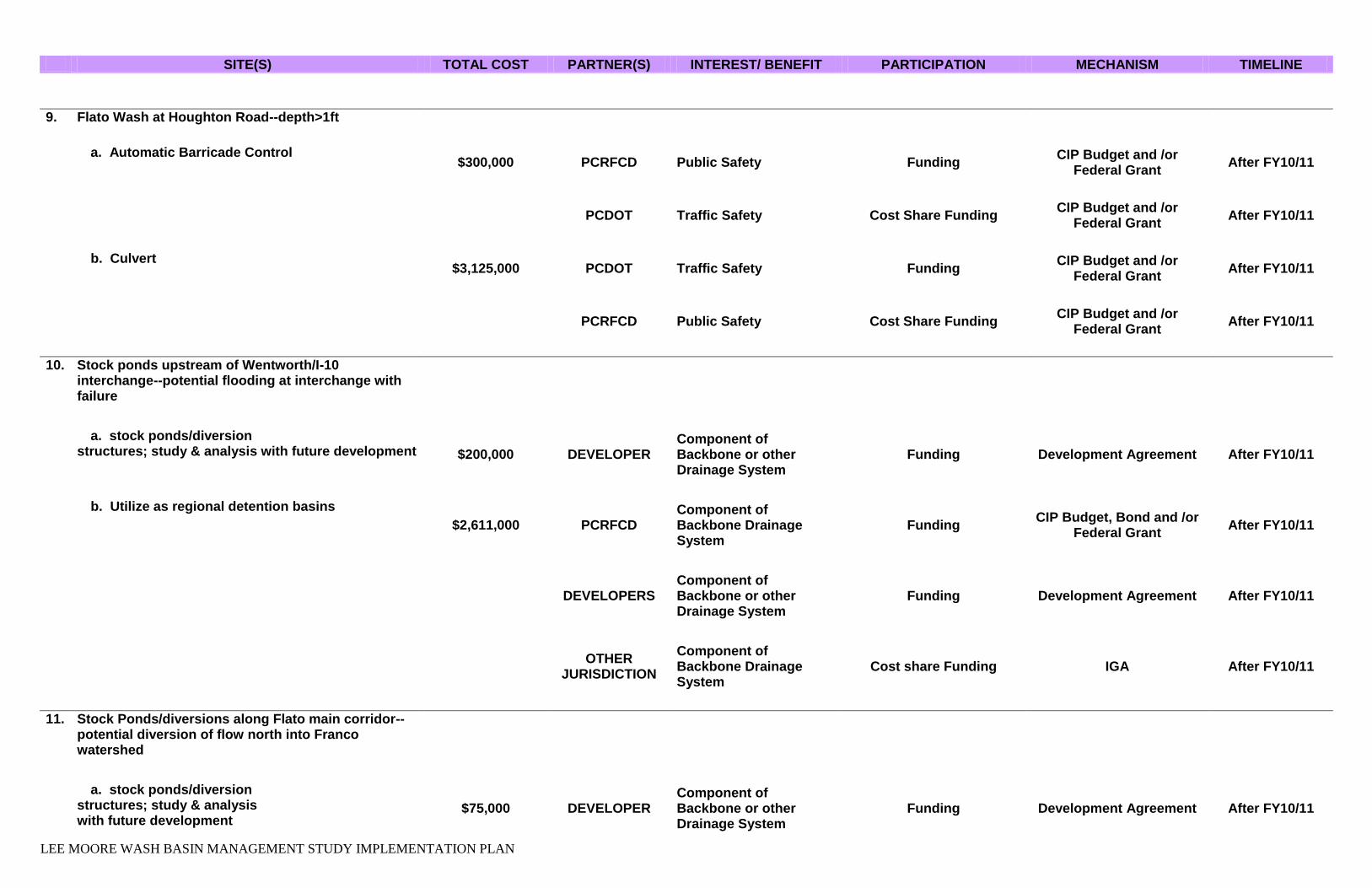
9. Flato Wash at Houghton Road--depth>1ft
a. Automatic Barricade Control $300,000 PCRFCD Public Safety Funding
CIP Budget and /or Federal Grant
After FY10/11
PCDOT Traffic Safety Cost Share Funding
CIP Budget and /or Federal Grant
After FY10/11
b. Culvert $3,125,000 PCDOT Traffic Safety Funding
CIP Budget and /or Federal Grant
After FY10/11
PCRFCD Public Safety Cost Share Funding
CIP Budget and /or Federal Grant
After FY10/11
10. Stock ponds upstream of Wentworth/I-10 interchange--potential flooding at interchange with failure
a. stock ponds/diversion structures; study & analysis with future development $200,000 DEVELOPER
Component of Backbone or other Drainage System
Funding Development Agreement After FY10/11
b. Utilize as regional detention basins
$2,611,000 PCRFCD Component of Backbone Drainage System
Funding CIP Budget, Bond and /or
Federal Grant After FY10/11
DEVELOPERS Component of Backbone or other Drainage System
Funding Development Agreement After FY10/11
OTHER
JURISDICTION
Component of Backbone Drainage System
Cost share Funding IGA After FY10/11
11. Stock Ponds/diversions along Flato main corridor--potential diversion of flow north into Franco watershed
a. stock ponds/diversion structures; study & analysis with future development
$75,000 DEVELOPER Component of Backbone or other Drainage System
Funding Development Agreement After FY10/11

LEE MOORE WASH BASIN MANAGEMENT STUDY IMPLEMENTATION PLAN
SITE(S) TOTAL COST PARTNER(S) INTEREST/ BENEFIT PARTICIPATION MECHANISM TIMELINE
b. Utilize as regional detention basins
$979,125 PCRFCD Component of Backbone Drainage System
Funding CIP Budget, Bond and /or
Federal Grant After FY10/11
DEVELOPERS Component of Backbone or other Drainage System
Funding Development Agreement After FY10/11
OTHER
JURISDICTION
Component of Backbone Drainage System
Cost share Funding IGA After FY10/11
12. New Tucson all-weather access issues at several crossings; undersized culverts at several crossings
a. Maintain culverts, upgrade culvert size $2,415,750 PCDOT Traffic Safety Funding
CIP Budget and /or Federal Grant
After FY10/11
b. Close access points $545,600 PCDOT Traffic Safety Funding
CIP Budget and /or Federal Grant
After FY10/11
PCRFCD Public Safety Cost share Funding
CIP Budget, Bond and /or Federal Grant
After FY10/11
13. Impacts of stock ponds/diversion structures south of Sahuarita Road and New Tucson area
a. stock ponds/diversion structures; study & analysis with future development $250,000 DEVELOPER
Component of Backbone or other Drainage System
Funding Development Agreement After FY10/11
b. Utilize as regional detention basins
$3,263,750 PCRFCD Component of Backbone Drainage System
Funding CIP Budget, Bond and /or
Federal Grant After FY10/11
DEVELOPERS Component of Backbone or other Drainage System
Funding Development Agreement After FY10/11

LEE MOORE WASH BASIN MANAGEMENT STUDY IMPLEMENTATION PLAN
SITE(S) TOTAL COST PARTNER(S) INTEREST/ BENEFIT PARTICIPATION MECHANISM TIMELINE
OTHER
JURISDICTION
Component of Backbone Drainage System
Cost share Funding IGA After FY10/11
CUPRITE/FAGAN/PETTY RANCH AREA ALTERNATIVES
1. FICO Channel lacks capacity to convey flow north, breakout/flooding to west
a. No Action N/A - - - - - - - - - - - -
2. Sahuarita Road-all-weather access limited from east near Wentworth Road to Houghton
a. Culverts
$1,306,875 RTA Traffic Safety as Part of Regional Transportation Corridor
Funding CIP Funding After FY10/11
PCRFCD Public Safety Cost share Funding
CIP Budget and /or Federal Grant
After FY10/11
PCDOT Traffic Safety Cost share Funding
CIP Budget and /or Federal Grant
After FY10/11
b. Maintain culverts, upgrade culvert size $357,000 PCDOT Traffic Safety Funding CIP & Maintenance Budget After FY10/11
PCRFCD Public Safety Cost share Funding
CIP Budget and /or Federal Grant
After FY10/11
3. Approx. 2 miles of Sahuarita Road - Houghton Road to Rita Road alignment
a. Culverts
$4,235,000 RTA Traffic Safety as Part of Regional Transportation Corridor
Funding CIP Funding After FY10/11
PCRFCD Public Safety Cost share Funding
CIP Budget and /or Federal Grant
After FY10/11

LEE MOORE WASH BASIN MANAGEMENT STUDY IMPLEMENTATION PLAN
SITE(S) TOTAL COST PARTNER(S) INTEREST/ BENEFIT PARTICIPATION MECHANISM TIMELINE
PCDOT Traffic Safety Cost share Funding
CIP Budget and /or Federal Grant
After FY10/11
b. Maintain culverts, upgrade culvert size
$15,000 RTA Traffic Safety as Part of Regional Transportation Corridor
Funding CIP Funding After FY10/11
PCRFCD Public Safety Cost share Funding
CIP Budget and /or Federal Grant
After FY10/11
PCDOT Traffic Safety Cost share Funding
CIP Budget and /or Federal Grant
After FY10/11
4. Houghton Road-all-weather access limited from north
a. Automatic Barricade Control $300,000 PCRFCD Public Safety Funding CIP Budget After FY10/11
PCDOT Traffic Safety Cost Share Funding
CIP Budget and /or Federal Grant
After FY10/11
b. Provide all weather access
$6,658,596 RTA Traffic Safety as Part of Regional Transportation Corridor
Funding CIP Funding After FY10/11
PCDOT Public Safety Cost share Funding
CIP Budget and /or Federal Grant
After FY10/11
PCRFCD Traffic Safety Cost share Funding
CIP Budget and /or Federal Grant
After FY10/11
c. Culverts
$5,326,875 RTA Traffic Safety as Part of Regional Transportation Corridor
Funding CIP Funding After FY10/11
PCDOT Public Safety Cost share Funding
CIP Budget and /or Federal Grant
After FY10/11
PCRFCD Traffic Safety Cost share Funding
CIP Budget and /or Federal Grant
After FY10/11

LEE MOORE WASH BASIN MANAGEMENT STUDY IMPLEMENTATION PLAN
SITE(S) TOTAL COST PARTNER(S) INTEREST/ BENEFIT PARTICIPATION MECHANISM TIMELINE
5. Houghton, Sahuarita Area--flooding/erosion issues
a. No Action N/A
SYCAMORE CANYON & GUNNERY RANGE AREAS ALTERNATIVES
1. Sahuarita Road-Rita Road alignment to Nogales hwy
a. Culverts
$8,855,625 RTA Traffic Safety as Part of Regional Transportation Corridor
Funding CIP Funding After FY10/11
PCRFCD Public Safety Cost share Funding
CIP Budget and /or Federal Grant
After FY10/11
PCDOT Traffic Safety Cost share Funding
CIP Budget and /or Federal Grant
After FY10/11
b. Maintain culverts, upgrade culvert size
$967,500 RTA Traffic Safety as Part of Regional Transportation Corridor
Funding CIP Funding After FY10/11
PCRFCD Public Safety Cost share Funding
CIP Budget and /or Federal Grant
After FY10/11
PCDOT Traffic Safety Cost share Funding
CIP Budget and /or Federal Grant
After FY10/11
2. Undersized/clogged culverts in Sycamore Canyon Estates south of Sahuarita Road
a. Maintain culverts, upgrade culvert size $27,000 PCDOT Traffic Safety CIP Funding
CIP Budget and /or Federal Grant
After FY10/11
PCRFCD Public Safety Cost share Funding
CIP Budget and /or Federal Grant
After FY10/11
3. Complaints about integrity of berm along Columbus Blvd, north of Dawson, east of Irving

LEE MOORE WASH BASIN MANAGEMENT STUDY IMPLEMENTATION PLAN
SITE(S) TOTAL COST PARTNER(S) INTEREST/ BENEFIT PARTICIPATION MECHANISM TIMELINE
a. No Action N/A
4. Sahuarita, Delgado, Dawson: FICO channel--lack of capacity/sedimentation causes residential flooding
a. FLAP
$23,062,806 PCRFCD Remove Repetitive Loss Properties from Floodplain
Funding PCRFCD Budget After FY10/11
b. Regional detention basins
$14,881,300 PCRFCD Component of Backbone Drainage System
Funding CIP Budget, Bond and /or
Federal Grant After FY10/11
DEVELOPERS Component of Backbone or other Drainage System
Funding Development Agreement After FY10/11
OTHER
JURISDICTION
Component of Backbone Drainage System
Cost share Funding IGA After FY10/11
c. Construct 100-year channel
$2,541,000 PCRFCD Component of Backbone Drainage System
Funding CIP Budget, Bond and /or
Federal Grant After FY10/11
DEVELOPERS Component of Backbone or other Drainage System
Funding Development Agreement After FY10/11
OTHER
JURISDICTION
Component of Backbone Drainage System
Cost share Funding IGA After FY10/11

LEE MOORE WASH BASIN MANAGEMENT STUDY IMPLEMENTATION PLAN
Table B Recommended Alternatives Summary – Future Conditions
SITE(S) TOTAL COST PARTNER(S) INTEREST/ BENEFIT PARTICIPATION MECHANISM TIMELINE
AREA WIDE ALTERNATIVES
1. Develop Backbone Drainage Infrastructure a. Delineate and preserve flow corridors
$504,500,000 All Agencies and
Developers
Component of Backbone Drainage System
Regulatory Preservation Requirement
Resolution and/or Special Area Plan
FY10/11
After FY10/11
b. Regional detention basins
$127,692,675 PCRFCD Component of Backbone Drainage System
Funding CIP Budget, Bond and /or
Federal Grant After FY10/11
DEVELOPERS Component of Backbone or other Drainage System
Funding Development Agreement After FY10/11
OTHER
JURISDICTION
Component of Backbone Drainage System
Cost share Funding IGA After FY10/11
c. Development Criteria
No cost All Agencies and
Developers
Component of Backbone Drainage System
Regulatory Development Requirement
Resolution and/or Ordinance
FY10/11
2. Identify and Disclose Flood Hazard Information
a. Delineate additional FEMA floodplains $1,665,000 PCRFCD Hazard Delineation
Regulatory Development Requirement
RFCD Operating Budget After FY10/11
b. Public Education and Outreach $30,000 PCRFCD
Flooding Education/CRS Credits
Funding PDD Budget FY10/11

LEE MOORE WASH BASIN MANAGEMENT STUDY IMPLEMENTATION PLAN
SITE(S) TOTAL COST PARTNER(S) INTEREST/ BENEFIT PARTICIPATION MECHANISM TIMELINE
FRANCO/FLATO/SUMMIT AREA
1. 50% of Wilmot Road & Kolb Road alignments are impacted by defined floodplain areas
a. Realign Wilmot Road ($606,061)
PAG/RTA/PCDOT/COTDOT
Keeps Roadway out of Floodplain
Southeast Arterial study Revision
RTA Budget After FY10/11
2. Country Club Road alignment impacted by main flow corridors of Franco Wash and Flato Wash
a. Realign Country Club Road ($1,060,606)
PAG/RTA/PCDOT/COTDOT
Keeps Roadway out of Floodplain
Southeast Arterial study Revision
RTA Budget Before June 2011
3. Intersection at Dawn Road & I-10 located within floodprone area
a. Relocate intersection $1,136,364 PCDOT
Keeps Roadway out of Floodplain
Funding PCDOT Budget After FY10/11
CUPRITE/FAGAN/PETTY RANCH AREA ALTERNATIVES
1. Proposed Dawn Road alignment swings south into flood hazard area, +/- 1/3 mile flow depths >0.5ft
a. Realign roadway ($757,576.00)
PAG/RTA/PCDOT/COTDOT
Keeps Roadway out of Floodplain
Southeast Arterial study Revision
RTA Budget After FY10/11
2. 60-65% of proposed Wilmot Road & Rita Road alignments impacted by defined floodplain areas
a. Realign Wilmot Road ($3,030,303)
PAG/RTA/PCDOT/COTDOT
Keeps Roadway out of Floodplain
Southeast Arterial study Revision
RTA Budget After FY10/11
3. Swan Road Alignment--situated within sheet flow area north of Sahuarita Road

LEE MOORE WASH BASIN MANAGEMENT STUDY IMPLEMENTATION PLAN
SITE(S) TOTAL COST PARTNER(S) INTEREST/ BENEFIT PARTICIPATION MECHANISM TIMELINE
a. Remove roadway section ($10,984,848) RTA
Keeps Roadway out of Floodplain
Southeast Arterial study Revision
RTA Budget After FY10/11
4. Pima Mine Road--from Houghton to Wilmot is within shallow sheet flow; divert flow to Cuprite watershed
a. No Action NA
5. Hook M Ranch property--40-50% of property impacted by shallow sheet flow
a. Delineate and preserve flow corridors
$28,900,000 All Agencies
and Developers
Component of Backbone Drainage System
Regulatory Preservation Requirement
Resolution and/or Ordinance
FY10/11
b. Development Criteria
No cost All Agencies
and Developers
Component of Backbone Drainage System
Regulatory Development Requirement
Resolution and/or Ordinance
FY10/11
SYCAMORE CANYON & GUNNERY RANGE AREAS ALTERNATIVES
1. Wilmot Road & Dawson Road proposed alignments
situated in areas dominated by shallow sheet flow
a. No Action NA
2. Sycamore Canyon Blocks C-G--plan platted, currently undeveloped; flood hazard areas fairly contained

LEE MOORE WASH BASIN MANAGEMENT STUDY IMPLEMENTATION PLAN
SITE(S) TOTAL COST PARTNER(S) INTEREST/ BENEFIT PARTICIPATION MECHANISM TIMELINE
a. Delineate and preserve flow corridors
No cost All Agencies and
Developers
Component of Backbone Drainage System
Regulatory Preservation Requirement
Resolution and/or Ordinance
FY10/11
b. Development Criteria
No cost All Agencies and
Developers
Component of Backbone Drainage System
Regulatory Development Requirement
Resolution and/or Ordinance
FY10/11

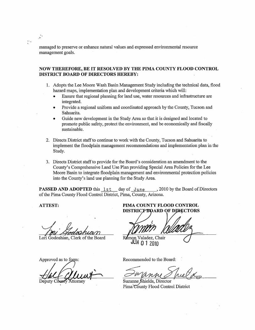
Appendix A Pima County Flood Control District Board of Directors Resolution


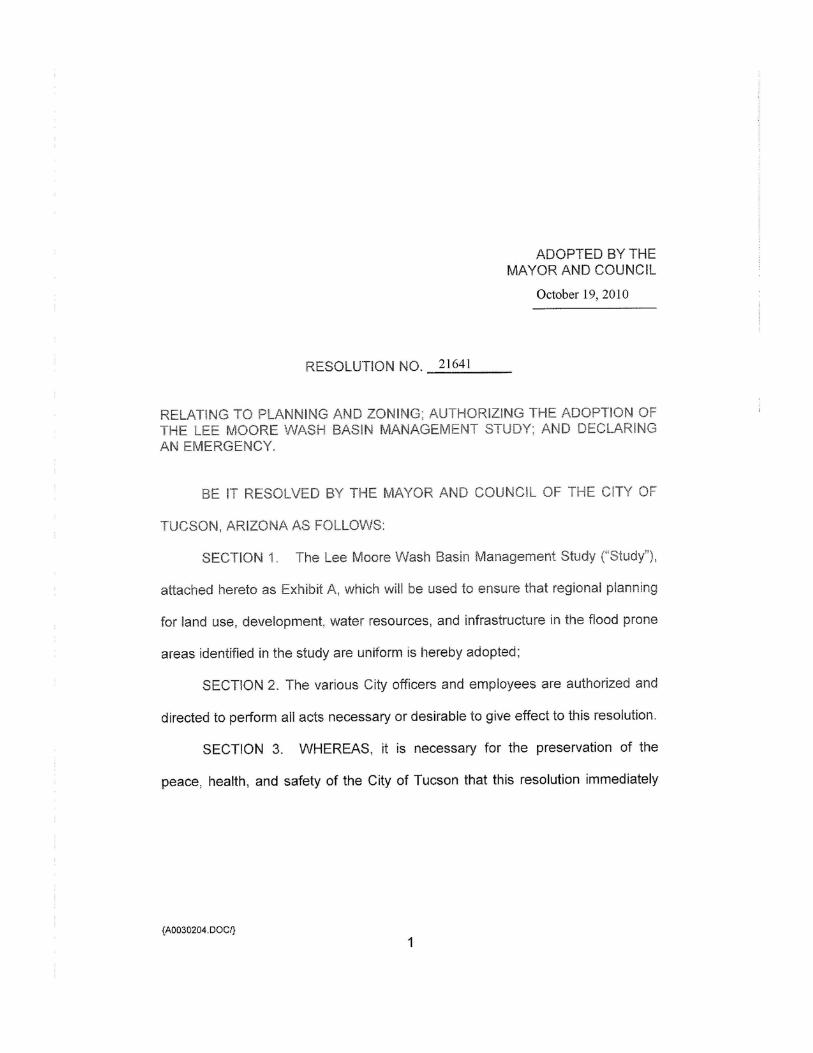
Appendix B City of Tucson Resolution


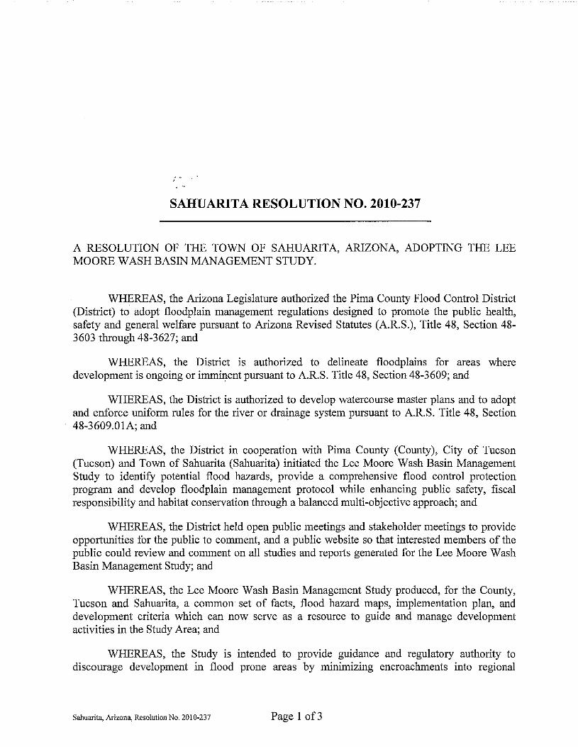
Appendix C Town of Sahuarita Resolution

Appendix D Arizona State Land Department Letter of Concurrence


Appendix E Development Criteria

DEVELOPMENT CRITERIA for the
LEE MOORE WASH BASIN
MANAGEMENT STUDY
Adopted by Pima County June 1, 2010
Adopted by the City of Tucson October 19, 2010
Adopted by the Town of Sahuarita December 13, 2010

Development Criteria Page i Pima County Regional Flood Control District
TABLE OF CONTENTS………………………………………………………………….PAGE SECTION 1: INTRODUCTION ....................................................................................... 1 1.1 Background & Applicability ............................................................................... 1
1.2 Implementation ................................................................................................... 4
1.3 Objectives ........................................................................................................... 4
1.4 Authority ............................................................................................................. 6
1.5 Summary ............................................................................................................. 7
SECTION 2: FLOOD-HAZARD AREAS ........................................................................ 8 2.1 Overview ............................................................................................................. 8
2.2 Riverine Areas .................................................................................................... 8
2.3 Distributary Flow Areas ................................................................................... 11
2.4 Ponding Areas .................................................................................................. 14
SECTION 3: STRUCTURAL CATEGORIES ................................................................ 17 3.1 Road Crossings ................................................................................................ 17
3.2 Stock Ponds ...................................................................................................... 18
3.3 Stormwater Detention Facilities ...................................................................... 20
3.4 Utility Crossings ............................................................................................... 22
3.5 Culverts & At-grade Crossings ....................................................................... 23
3.6 Levees & Embankments .................................................................................. 27
3.7 Channelization .................................................................................................. 30
SECTION 4: NON-STRUCTURAL/REGULATORY CATEGORIES ............................. 33 4.1 Erosion-Hazard Setbacks ................................................................................ 33
4.2 Flow Corridors .................................................................................................. 38
4.3 Water Harvesting .............................................................................................. 43
4.4 Disturbance Envelopes .................................................................................... 45
Development Criteria Page ii Pima County Regional Flood Control District
4.5 Walls & Fences ................................................................................................. 47
SECTION 5: MAINTENANCE ...................................................................................... 49 5.1 Inspection and Maintenance Practices ........................................................... 49
SECTION 6: SUMMARY .............................................................................................. 56 6.1 Summary ........................................................................................................... 56
SECTION 7: APPENDICES .......................................................................................... 58 7.1 Authority ........................................................................................................... 58
7.1.1 Arizona Revised Statutes ............................................................................. 58
7.2 Drainage and Development Regulations ........................................................ 58
7.2.1 City of Tucson .............................................................................................. 58
7.2.2 Pima County Regional Flood Control District ............................................... 58
7.2.3 Town of Sahuarita ........................................................................................ 58

Development Criteria Pima County Regional Flood Control District
Page 1
SECTION 1: INTRODUCTION
1.1 Background & Applicability Historically, Arizona communities have developed floodplain-management measures such as floodplain ordinances, drainage ordinances, and development standards intended to mitigate the flood impacts of urbanization. If these measures are not adequate or are not adequately enforced, the consequences may include flooding of homes and businesses, displacement of existing natural flood flows, increased flood depths and flow velocities, and flooding of lands previously not in a floodplain. Adverse impacts of urbanization on drainage often include the following:
a. More Frequent Flooding. As the land area within a watershed is
urbanized, less rainfall infiltrates into the ground and more rainfall becomes runoff. This results in more frequent runoff events and increased nuisance flooding.
b. Larger Flood Peaks. The change from natural, pervious land surfaces to urbanized, impervious surfaces also causes the size of floods to increase, as more runoff is generated within, and emanates from, the watershed. Urbanized watersheds generate not only larger flood peaks, but also larger flood volumes and floods of longer duration, both of which increase flood damages. As flood peaks increase with urbanization, existing drainage structures may become inadequate and have a greater risk of failure.
c. Loss of Natural and Beneficial Floodplain Functions. Natural floodplains provide important sociological, as well environmental and hydrologic benefits. These sociological benefits include continuous linear open space, visual and aesthetic beauty, multi-sensory relief from pervasive constructed hardscapes, and a sense of community character tied to the natural setting. These environmental and hydrologic benefits include sustaining system sediment balance and riparian areas, thus avoiding man-made erosion and loss-of-wildlife issues.
Development Criteria Pima County Regional Flood Control District
Page 2
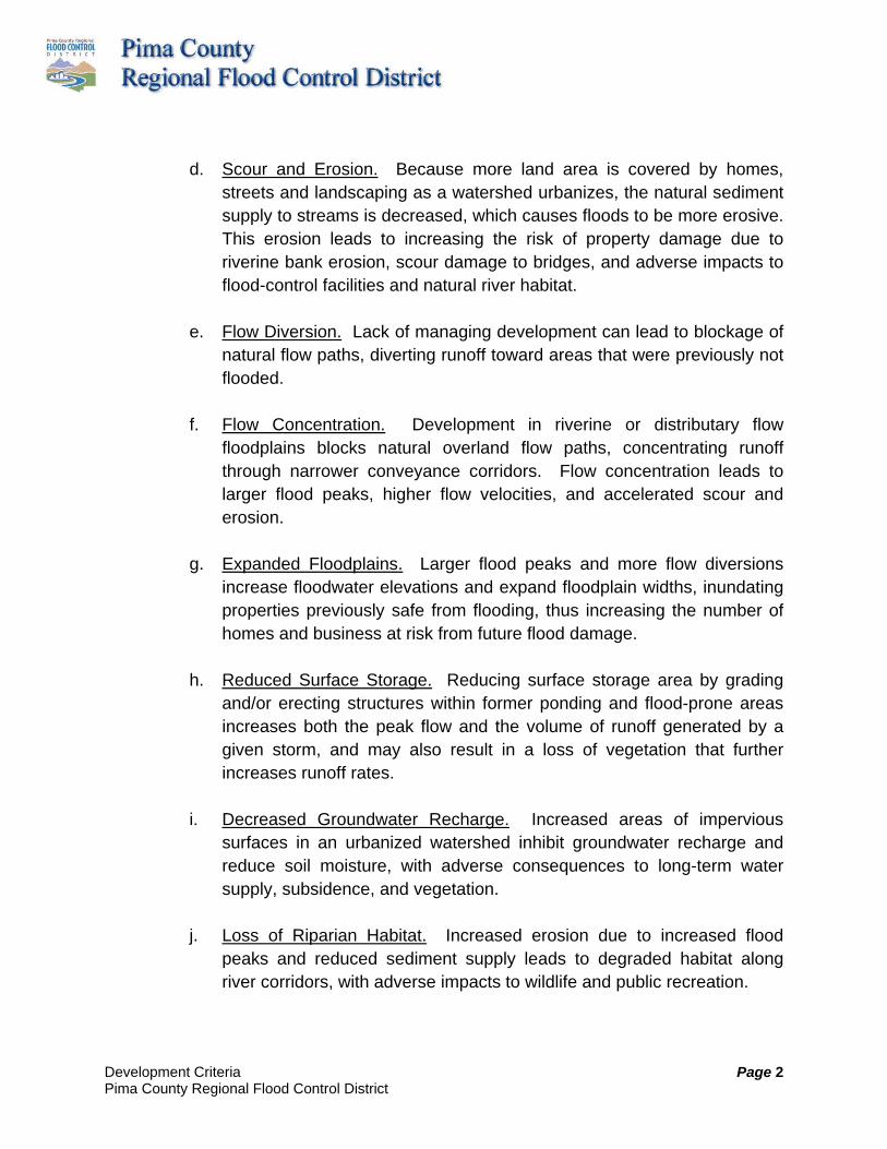
d. Scour and Erosion. Because more land area is covered by homes, streets and landscaping as a watershed urbanizes, the natural sediment supply to streams is decreased, which causes floods to be more erosive. This erosion leads to increasing the risk of property damage due to riverine bank erosion, scour damage to bridges, and adverse impacts to flood-control facilities and natural river habitat.
e. Flow Diversion. Lack of managing development can lead to blockage of natural flow paths, diverting runoff toward areas that were previously not flooded.
f. Flow Concentration. Development in riverine or distributary flow floodplains blocks natural overland flow paths, concentrating runoff through narrower conveyance corridors. Flow concentration leads to larger flood peaks, higher flow velocities, and accelerated scour and erosion.
g. Expanded Floodplains. Larger flood peaks and more flow diversions increase floodwater elevations and expand floodplain widths, inundating properties previously safe from flooding, thus increasing the number of homes and business at risk from future flood damage.
h. Reduced Surface Storage. Reducing surface storage area by grading and/or erecting structures within former ponding and flood-prone areas increases both the peak flow and the volume of runoff generated by a given storm, and may also result in a loss of vegetation that further increases runoff rates.
i. Decreased Groundwater Recharge. Increased areas of impervious surfaces in an urbanized watershed inhibit groundwater recharge and reduce soil moisture, with adverse consequences to long-term water supply, subsidence, and vegetation.
j. Loss of Riparian Habitat. Increased erosion due to increased flood peaks and reduced sediment supply leads to degraded habitat along river corridors, with adverse impacts to wildlife and public recreation.

Development Criteria Pima County Regional Flood Control District
Page 3
In order to protect private and public property, as well as the health and general welfare of the public, naturally occurring flood hazards and potential flood hazards related to development need to be identified, and appropriate standards applied to safely manage new development. Development Criteria are a work product of a Basin Management Study (BMS). This study includes a hydrologic assessment of the watershed, identifies potential flood-prone areas and drainage problems, and offers alternatives to mitigate flooding and related impacts of urbanization within a watershed. A key part of this BMS includes identification of new development criteria. Adherence to these development criteria will substantially lessen the adverse impacts of urbanization and will decrease the cost of mitigating flooding for the public and private sectors.
Development of this BMS included compiling information, identifying and analyzing alternatives, and selecting Recommended Alternatives (RA). The RA contain both structural solutions (such as basins, culverts, and channels) and non-structural solutions (such as development criteria, flood warning system, and property acquisition). The Lee Moore Wash study area is located in the southeast portion of Pima County, and includes a portion of the City of Tucson and the Town of Sahuarita. The northern half of the study area lies predominantly within the incorporated limits of the City of Tucson. A small area in the southwestern portion of the study area lies within the bounds of the Town of Sahuarita. The majority of the central study area is located within unincorporated Pima County. Approximately the southern two-thirds of the Lee Moore Wash watershed are characterized by distributary flooding. Much of this area is undeveloped. Counties and cities generally have what many consider adequate authority to regulate residential subdivisions, multi-family, industrial and commercial projects, and address potential flooding and related impacts on adjacent properties. Unlike cities, however, counties lack the regulatory authority to adequately manage lot splits (i.e., those exempt from subdivision and/or other improvement requirements due to the small number of lots involved). Although impacts from lot-split development may appear relatively insignificant on an individual lot-by-lot basis, the cumulative impacts over the long term may be significant.

Development Criteria Pima County Regional Flood Control District
Page 4
Over the past few decades the County has been managing floodplain areas it has become apparent that there is a lack of tools to adequately manage individual lot development, especially lots located within distributary flow areas. As part of this BMS, it was determined that Development Criteria focused on single-family development on individual lots, standard subdivisions and/or large master-planned developments could reduce flood- and erosion-related damage within the Lee Moore Wash watershed.
Approximately 48 percent of the Study area is owned by the state of Arizona and managed by the Arizona State Land Department (ASLD). ASLD manages lands in compliance with the State Enabling Act, the Arizona Constitution, and with Arizona Revised Statutes Title 37, which all require that State Trust Lands be managed in the best interests of the designated State Trust beneficiaries. As such, certain elements of the Development Criteria presented herein may not have the same regulatory compliance authority with regard to State Trust Lands as they do to land owned by others. Nevertheless, the principles, policies, and practices contained within these Development Criteria provide a useful method for insuring a consistent and comprehensive approach to floodplain management within the Study area. Therefore, it is in the best interest of all land owners and jurisdictions to comply with these Development Criteria to the fullest extent possible.
1.2 Implementation
Implementation of these Development Criteria are addressed in Volume 3 of the Lee Moore Wash Basin Management Study.
1.3 Objectives The Lee Moore Wash BMS identifies flooding and erosion hazards in the study area and recommends alternatives to mitigate those hazards. Both structural and non-structural measures are incorporated into the recommended alternatives to address drainage and flooding problems. The Development Criteria are one of the non-structural components of the recommended alternatives. General objectives of the Development Criteria are as follows.
Development Criteria Pima County Regional Flood Control District
Page 5
1.3.1 General Objectives
a. Enhance public safety by guiding development in the watershed to protect current and future residents from flood and erosion related impacts.
b. Reduce adverse drainage and related impacts due to development in the
watershed by guiding activities of residents so that future runoff into the Santa Cruz River is maintained at current conditions to preclude negative impacts to downstream and upstream neighbors.
c. Guide future development in a manner consistent with the recommended
alternatives of the Lee Moore Wash BMS.
1.3.2 Specific Objectives The following specific objectives were established to guide the development of the recommended Development Criteria, as presented herein, and their implementation.
a. Use existing aerial photography, topographic data, and GIS database resources to the maximum extent possible.
b. Use available resources and the work products of the BMS, including
floodplain delineations, geomorphic evaluation, stakeholder involvement, public involvement and identification of drainage problems, to enhance the suitability and applicability of the Development Criteria.
c. Provide the citizenry with as much upfront information as possible about
the process and permit requirements in order to minimize cost and time investments for all parties.
d. Allow for maximum flexibility in the review process so that Floodplain Use
Permit applicants may proceed with single-lot and subdivision development, and may incorporate drainage features that do not explicitly meet the Development Criteria established herein—provided plans for such features are designed and sealed by a registered professional engineer and reviewed and approved by the local floodplain management

Development Criteria Pima County Regional Flood Control District
Page 6
agency having jurisdiction. e. Utilize Development Criteria consistent and compatible with existing
statutes, ordinances, and regulations. f. Limit the use of Development Criteria to those criteria necessary to
address problems in the Lee Moore Wash watershed which are not adequately addressed by existing Floodplain or Drainage Regulations.
The proposed Development Criteria for the Lee Moore Wash BMS are consistent with the general and specific objectives set forth above.
1.4 Authority The authority for counties, cities, and towns in Arizona to manage floodplains within their respective jurisdictions is authorized by the state of Arizona. Applicable state statutes providing for the use of Development Criteria by local governments are summarized below. Arizona Revised Statutes (Excerpted)
a. ARS 11-251.36. Subject to the prohibitions, restrictions and limitations as set forth in section 11-830, adopt and enforce standards for excavation, landfill and grading to prevent unnecessary loss from erosion, flooding and landslides.
b. ARS 48-2664.D. The Board may adopt equitable by-laws, rules and regulations and perform all acts necessary to carry out the purposes of this chapter.
c. ARS 48-3609.B. Except as provided in section 48-3610, the board shall adopt and enforce regulations governing floodplains and floodplain management in its area of jurisdiction which shall include the following:
i. Regulations for all development of land, construction of residential, commercial or industrial structures or uses of any kind which may divert, retard or obstruct floodwater and threaten public health or safety or the general welfare.

Development Criteria Pima County Regional Flood Control District
Page 7
d. ARS 48-3609.01.A. If a district organized pursuant to this chapter has
completed a watercourse master plan which includes one or more watercourses, and if the plan has been adopted by the board and subsequently adopted by the other local jurisdiction(s) in that river or drainage system, then the board and the governing body of each jurisdiction may adopt and shall enforce uniform rules for the river or drainage system within the jurisdiction using criteria that meet or exceed criteria adopted by the director of water resources pursuant to section 48-3605, subsection A.
1.5 Summary
An analysis of the BMS area-development trends and regulatory options was conducted to identify specific issues not addressed by existing drainage and floodplain regulations. Based on that analysis, it was determined that single-family development on individual lots, as well as master-planned subdivisions, would benefit from Development Criteria formulated specifically for the Lee Moore Wash watershed. Implementation of Development Criteria intended to reduce drainage, flood, and erosion hazards will lessen public expenditures for structural flood-control measures, will decrease the amount of maintenance needed for flood-control facilities, will complement riparian-habitat regulations, and will lessen the need to acquire public right-of-way for flood-control purposes. In addition, application of Development Criteria will reduce flood-damage potential to private and public property, as well as the need for public funding for flood mitigation and repair of flood damage.

Development Criteria Pima County Regional Flood Control District
Page 8
SECTION 2: FLOOD-HAZARD AREAS
2.1 Overview
The Study Area is subject to two major types of Flood Hazards: Riverine and Distributary Flow. Riverine areas are concentrated in the northern part of the Lee Moore Wash watershed; while Distributary Flow areas are found in the central and southern portions of the watershed. Due to the difference in flood hazards associated with the two flooding types, the following Development Criteria are proposed.
2.2 Riverine Areas
In addition to any other rules, policies, and standards that may apply, the following criteria shall apply in the Study Area. 2.2.1 Criteria
a. Floodplain delineations shall be conducted in conformance with Federal
Emergency Management Agency (FEMA) Guidelines, Arizona Department of Water Resources (ADWR) State Standards, and local regulatory regulations. When development impacts non-FEMA-designated floodplains, floodplain delineations will be for local floodplain management purposes only, and need not be submitted to or approved by FEMA.
b. Development in FEMA-designated floodplains shall be governed by the
most recent National Flood Insurance Program (NFIP) Regulations, ADWR State Standards, and any requirement by the local jurisdiction having authority. Anyone proposing development that alters a FEMA floodplain limit or base flood elevation is required by NFIP regulations to submit a Conditional Letter of Map Revision to FEMA for review and approval prior to construction, if appropriate. A Letter of Map Revision shall also be submitted to FEMA for review and approval prior to the Final Release of Assurances for subdivisions, and Certificate of Occupancy for Development Plans; but partial-assurance releases,
Development Criteria Pima County Regional Flood Control District
Page 9
along with temporary Certificates of Occupancy, are allowable at the discretion of the local jurisdiction.
c. Development in, or modification of, the floodplain is generally
discouraged. Development should be located outside the 100-year floodplain wherever possible. If site characteristics require development within the floodplain, the floodplain modifications should be minimized in order to lessen impacts on the natural stormwater and sediment-transport capacity of the floodplain.
d. The placement or development of critical facilities, as defined by FEMA,
shall also be discouraged in the Riverine Floodplain of the Study Area. e. Changes to natural drainage patterns in the interior of individual
properties should be avoided whenever possible. The point(s) where regulatory drainage enters and exits a parcel shall not be altered without the express written consent of all affected property owners and unless an engineering study demonstrating no adverse impacts to affected land parcels is submitted to and approved by the flood-control agency having jurisdiction.
f. The lowest finished-floor elevation of all habitable structures (those
structures which are constructed and permitted for human occupancy, whether on a full- or part-time basis) within a FEMA or other regulatory floodplain shall be at least one (1) foot above the highest natural adjacent grade. Highest natural adjacent grade is defined as the highest pre-construction/pre-grading ground elevation within the footprint of the proposed structure. For development within a floodplain, the minimum finished-floor elevation of all habitable structures shall be set to the regulatory flood elevation, which is one (1) foot above the base flood elevation.
g. All development in a Regulatory Floodway shall comply with applicable
local, state, and federal standards. A "Regulatory Floodway" means the channel of a river or other watercourse and the adjacent land areas that must be reserved in order to discharge the base flood without cumulatively increasing the water-surface elevation by more than the
Development Criteria Pima County Regional Flood Control District
Page 10
designated height as defined by the floodplain ordinance of the agency having jurisdiction.
h. Encroachment means the advance of obstructive uses, such as fill, excavation, buildings, temporary or permanent structures or other development, into a floodplain, in a manner which may impede or alter the flow capacity of a floodplain. Encroachment is allowed only where it can be demonstrated by an engineering analysis that no long-term or short-term off-site impacts are expected to occur, that neighboring properties are not adversely affected, and that the encroachment is adequately protected from erosion and flooding hazards. Also, a long-term inspection and maintenance program must be adopted by the property owner and approved by the floodplain management agency having jurisdiction.
i. The foundations of buildings constructed in the floodplain shall be
protected against scour. Where floodplain or overbank flow is concentrated by development, the post-construction (full build-out) condition 100-year hydraulic data shall be used to establish the parameters for scour-protection design.
j. Building sites shall be graded to direct nuisance runoff away from the
building pad and building interior. k. Buildings constructed in riverine floodplains shall be aligned parallel to
the primary flow direction in order to limit flow obstruction and allow for flow-path continuity.
2.2.2 Rationale In the study area, riverine floodplains of watercourses with discharges greater than 100 cubic feet per second (cfs) are found along portions of the Franco, Flato, Summit, and Lee Moore washes. These watercourses include both the river channel and adjacent areas that are periodically inundated by floodwaters. For the purposes of these Development Criteria, a riverine floodplain only occurs along a defined stream channel.

Development Criteria Pima County Regional Flood Control District
Page 11
Floodplain means any land area susceptible to being inundated by water from any source. A riverine floodplain exists along a river or linear watercourse. Flood Hazard Zone means any land area located partially or wholly within a delineated floodplain that is susceptible to flood-related damage, as designated on the flood-management maps. Regulatory Flood Elevation, which is an Arizona state standard, means an elevation one foot above the base flood elevation for a watercourse for which the base flood elevation has been determined. Base Flood Elevation means the water-surface elevation produced by a base flood, or one-hundred-year flood. Certain riverine floodplains located within the area encompassing the Lee Moore Wash Basin Management Study area have been delineated on Flood Insurance Rate Maps or other flood-hazard maps published by the Federal Emergency Management Agency (FEMA), and are referred to as FEMA Floodplains. Some riverine floodplains in the Lee Moore Wash Basin Management Study area have been delineated by agencies, developers, or other parties; but have not been submitted, reviewed, or approved by FEMA. Per NFIP regulations, these floodplains may be used in the Lee Moore Wash Basin Management Study area as the best available information for floodplain-management purposes, which are based on local standards.
2.3 Distributary Flow Areas
In addition to any other rules, policies, and standards that may apply, the following criteria shall apply in the Study Area. 2.3.1 Criteria
a. Development in, or modification of, the floodplain is generally
discouraged. Development should be located outside the 100-year floodplain wherever possible. If site characteristics require that some development occur within the floodplain, the floodplain modifications should be the minimum possible to lessen impacts to the natural stormwater and sediment-transport capacity of the floodplain.

Development Criteria Pima County Regional Flood Control District
Page 12
b. Development in regulatory distributary flow areas should not concentrate
flows or eliminate flow paths that change the flow rate or flow distribution on adjacent parcels.
c. A drainage master plan is required for any subdivision plat or
development plan located in distributary areas. The drainage master plan should demonstrate that the roadway network that serves the development has acceptable impacts relative to drainage patterns and runoff concentration. Drainage design in distributary flow areas shall limit the concentration of flows. Where flows are concentrated, appropriate scour protection shall be provided along the channel reach. Concentrated flows shall be returned to the natural distributary flow condition prior to exiting the property.
d. Finished-floor elevations of all habitable structures (those structures
constructed and permitted for human occupancy, whether on a full- or part-time basis) within a FEMA or other regulatory floodplain shall be at least (1) foot above the highest natural adjacent grade. Highest natural adjacent grade is defined as the highest pre-construction/pre-grading ground elevation within the footprint of the proposed structure. For development within a floodplain, the minimum finished-floor elevation of all habitable structures shall be at least one (1) foot above the regulatory flood elevation, which is one (1) foot above the base flood elevation. In addition, the finished-floor elevation for new construction may be estimated using the procedures cited in State Standard 4-95.
e. For drainage design purposes, if a hydraulic rating is used to determine
flow distribution at a flow-split, no less than 50% of the 100-year discharge upstream of the bifurcation should be used on any single channel downstream, unless a publicly maintained engineered structure controls the flow distribution. If no hydraulic modeling is provided, the full 100-year discharge upstream of the split should be used on all downstream channels.
f. Applicable engineering guidelines for estimating flow rates, designing
flood-control facilities, setting finished-floor elevations, and for
Development Criteria Pima County Regional Flood Control District
Page 13
performing other floodplain management tasks should be used in Distributary Flow areas.
g. The foundations of buildings constructed in the floodplain shall be
protected against scour. Where floodplain or overbank flow is concentrated by development, the post-construction (full build-out) condition 100-year hydraulic data shall be used to establish the parmeters for scour-protection design.
h. Building sites shall be graded to direct nuisance runoff away from the
building pad and building interior. i. Buildings constructed in distributary floodplains shall be aligned parallel
to the primary flow direction in order to limit flow obstruction and allow for flow-path continuity.
2.3.2 Rationale
Distributary flow areas occur within a significant portion of the Lee Moore Wash Basin Management Study area, and create difficulty for engineering design and floodplain management due to the uncertainty created by diverging flow paths. Development in distributary flow areas can cause changes to flow distributions and result in adverse impacts to downstream and adjacent properties. Distributary flow is a specific drainage pattern in which defined channels divide, such that the number of channels increase in the downstream direction. Distributary flow areas have channels which split and rejoin in a complex pattern. The number of channel forks commonly exceeds the number of channel confluences, creating a distributary, rather than tributary, drainage pattern. The separate channels downstream of a channel fork may have terraces independent of other channels within the distributary flow system. A distributary channel is a stream branch flowing away from the main stream and not rejoining it. Identifying characteristics of distributary flow areas include, but are not limited to, the following:
a. Low, but distinguishable topographic relief perpendicular to the primary
flow direction.

Development Criteria Pima County Regional Flood Control District
Page 14
b. Topographic relief sufficient to create isolated islands during flood conditions within the overall floodplain.
c. Channels that divide in the downstream direction so that the number of flow paths conveying floodwaters increase in the downstream direction.
d. An increase in vegetative density along flow lines extending laterally over an expansive area, with more uniform upland vegetation types found between flow lines.
e. During larger floods, the distribution of flow between various existing distributary flow paths may not be predictable.
f. Flow lines are relatively stable, especially during smaller floods.
g. Larger floods may cause isolated or widespread bank erosion and/or sediment deposition within the channel, which changes channel capacity and/or overbank conveyance. Such conditions may lead to channel avulsion.
2.4 Ponding Areas
In addition to any other rules, policies, and standards that may apply, the following criteria shall apply in the Study Area. 2.4.1 Criteria
a. All areas upstream of embankments (such as roadway, canals, dams and earthen embankments) shall be evaluated to determine if ponding conditions exist. i. For Subdivisions and Commercial Development – Detailed
engineering analyses shall be performed to determine ponding elevations and flow patterns. Such analyses may include generation of hydrographs using detailed rainfall/runoff models, hydrologic and hydraulic routing of hydrographs, development of stage-storage-discharge relationships for the ponding area, hydraulic rating of outflow control structures, and hydraulic

Development Criteria Pima County Regional Flood Control District
Page 15
modeling of flow parallel to the impoundment structure. In some cases, two-dimensional modeling may be required to accurately account for both the hydrologic and hydraulic characteristics of the flooded area. The engineer should distinguish between static and flowing ponding areas when selecting the appropriate modeling tool(s).
ii. Single-Lot development - If no detailed ponding data are available, the ponding depth shall be assumed to be at least equal to the elevation of the embankment crest. The Floodplain Management agency having jurisdiction may require a detailed engineering analysis, as described above, if the ponding hazard appears severe or the flow patterns are complex.
b. The following criteria apply to development in ponding areas:
i. Discourage development in ponding areas behind (upstream of) embankments; and in areas downstream of embankments, where stormwater runoff overtops these structures during the 100-year or more frequent flood events.
ii. Onsite stormwater detention/retention shall be provided to decrease hydrostatic pressure on embankments.
iii. Avoid disrupting any existing drainage pathways located parallel to embankments, and maintain current flow and volume quantities along streets and roads.
c. Finished-floor elevations shall be at least one foot above the 100-year
ponding elevation. Where detailed information is not available, the finished-floor elevations for single-lot residential development may be set at least one foot above the structure crest controlling the ponding elevation.
d. Removing ponding areas by site-grading or by breaching the controlling
embankment are permitted only if an engineering analysis is performed that demonstrates no adverse impact to adjacent and upstream/downstream properties.
Development Criteria Pima County Regional Flood Control District
Page 16
2.4.2 Rationale Ponding is a type of floodplain in which flood levels are controlled by a structure that blocks or restricts flow, in which no well-defined channel exists, and where the floodwater has near-zero velocity. Ponding occurs in both natural and developed watersheds. Natural ponding areas occur in topographic depressions. They are somewhat rare, geologically short-lived features that tend to be filled with sediment over time. Man-made ponding areas are far more common than natural ponding areas, and are caused by constructed features, such as roadway embankments, levees, canals or railroad grades that block natural flow paths. Man-made ponding areas are often found in sheet and distributary flow areas where well-defined flow paths are lacking, like much of the Lee Moore Wash watershed. Ponding also typically occurs in agricultural areas where field leveling and irrigation structures block and obscure the natural drainage pattern.

Development Criteria Pima County Regional Flood Control District
Page 17
SECTION 3: STRUCTURAL CATEGORIES
3.1 Road Crossings
In addition to any other rules, policies, and standards that may apply, the following criteria shall apply in the Study Area. 3.1.1 Criteria
a. Roadway alignments shall be designed so that runoff collected by the
roadway is conveyed to its historic flow path to the maximum extent possible. Roadways shall be designed so as to not divert flows, unless it can be shown that the diversion will have minimal impact on the natural functioning of the subject watercourse.
b. Roadway crossings should be designed so the roadway alignment is
perpendicular to the watercourse in order to minimize disruption to the floodplain. The crossing should generally be located at the narrowest part of the floodplain. New roads shall be aligned to minimize placement of pavement within designated Flow Corridors. Road intersections should not be located over watercourses.
c. Roadway crossings are discouraged at locations where the watercourse
is braided. Where braided watercourses must be crossed, wide or multiple crossings that minimize flow contraction and disruption of sediment balance are recommended.
d. Roadway crossings should be designed to minimize downstream scour,
minimize the risk of erosion of roadway approaches, and maintain sediment balance up to the bank-full discharge. Scour protection is required to assure structure stability.
e. All crossings, regardless of the type, should be designed to minimize the
disruption of sediment-transport balance upstream and downstream of the crossing.

Development Criteria Pima County Regional Flood Control District
Page 18
3.1.2 Rationale
Roadway crossings of drainageways and floodplains can create considerable problems if not properly designed, constructed, and maintained. These problems include sediment-transport disruption, increased velocities and (potential) scour downstream of the crossing, ponding and (potential) flow diversion upstream of the crossing, and unintended overtopping of the roadway due to debris clogging of culverts and erosion of channel banks adjoining the crossing. Maintenance of roadway crossings is made more difficult by poorly located, designed or constructed crossings. Increased maintenance is required when culverts are undersized, which can cause ponding and sedimentation upstream, scour downstream, pavement damage from overtopping, and erosion of channel banks adjoining the crossing. Crossings that utilize the natural main-channel depth, width, and slope at the crossing location will have the least impact. Crossings that widen, narrow, deepen, or flatten the main channel may require frequent maintenance and may be more at risk of failure than crossings that maintain the natural channel geometry. Roadway crossings shall be consistent with all local, state, and federal ordinances and regulations regarding environmental issues and riparian habitat.
3.2 Stock Ponds
In addition to any other rules, policies, and standards that may apply, the following additional criteria shall apply in the Study Area. 3.2.1 Criteria
a. An engineering analysis of any upstream or onsite stock ponds is
required in order to determine the potential flood hazard posed to new development.
b. Based on the results of the analysis, stock ponds may be addressed by one of the following measures:

Development Criteria Pima County Regional Flood Control District
Page 19
i. Breaching and/or removing, if approved by the owner; ii. Improving the stock pond as warranted, so that it remains intact
during the 100-year flood. A maintenance plan with posted assurances will be needed, similar to what is required for other significant flood control structures. In this case, the stock pond may be used to reduce or off-set stormwater detention/retention requirements; or,
iii. Allowing the stock pond to remain in its existing condition, and addressing the flood hazard associated with pond failure, including the potential for a flood wave that exceeds the base flood floodplain, and the potential for redirection of flow outside of the historic floodplain.
c. If the stock pond needs to be mitigated or removed, all local, state, and federal ordinances and regulations pertaining to environmental and riparian issues shall be addressed.
3.2.2 Rationale
There are over 100 stock ponds within the Lee Moore Wash Basin Management Study area. Stock ponds typically consist of a non-engineered earthen dam of varying height placed across a watercourse to impound stormwater runoff. Vegetation typically lines the impoundment area on older facilities. Should downstream areas become developed, these non-engineered earthen dams may pose a hazard from potential flow diversions and/or overtopping. The ADWR Dam Safety Section has legal jurisdiction over dams (embankments) that exceed certain height and storage limits. ADWR currently defines a jurisdictional dam as "either 25 feet or more in height or stores more than 50 acre-feet. If it is less than six feet in height regardless of the storage capacity or does not store more than 15 acre-feet regardless of height, it is not jurisdictional." Even though a structure may not be considered jurisdictional, dams (embankments) in an urban environment may pose a significant flood hazard. As development occurs, the structural integrity, hydraulic influence, and the safety of existing stock ponds should be assessed relative to downstream impacts created by a dam break. A stock-pond analysis may indicate that the

Development Criteria Pima County Regional Flood Control District
Page 20
structure reduces downstream flooding, and is therefore beneficial. The analysis might also indicate that removing or breaching the structure would minimize downstream flood-hazard potential. Regardless, any analysis should address maintenance needs, as sedimentation and reduction of embankment integrity can occur over time if the structure is not properly maintained.
3.3 Stormwater Detention Facilities
In addition to any other rules, policies, and standards that may apply, the following criteria shall apply in the Study Area. 3.3.1 Criteria
a. Within the Study Area, only regional inline stormwater detention basins
are allowed in a Flow Corridor.
b. If a regional detention basin is proposed in a Flow Corridor, the basin must pass the 10-year existing pre-development flow in order to minimize disruption to sediment-transport rates.
c. All regional stormwater detention basins shall be analyzed and designed to accommodate multi-use functions in a manner determined by the floodplain management agency having jurisdiction.
d. Within the Study Area, all stormwater detention facilities shall be designed in accordance with the regulations, policies, and standards of the floodplain management agency having jurisdiction. This may include, but is not limited to:
i. Stormwater Detention/Retention Manual and Update; Pima County Department of Transportation and Flood Control District, City of Tucson
ii. Standards Manual for Drainage Design and Floodplain Management in Tucson, Arizona; City of Tucson Department of Transportation, Engineering Division
iii. State Standard for Stormwater Detention/Retention; Arizona Department of Water Resources, Flood Mitigation Section
Development Criteria Pima County Regional Flood Control District
Page 21
iv. Watercourse and Riparian Habitat Protection and Mitigation Requirements, Pima County Regional Flood Control District
v. Tucson Codes 23, 26, and 29, with related Policies and Standards, City of Tucson
vi. Guidelines for the Development of Regional Multi-Use Detention Basins in Pima County, Pima County Transportation and Flood Control District
3.3.2 Rationale Stormwater detention is widely used to mitigate the effects of urbanization on flood-peak discharges. Generally speaking, stormwater detention involves storing stormwater runoff emanating from urbanized areas and releasing it at flow rates that reflect natural or non-urbanized conditions which existed prior to development. Within the Lee Moore Wash Basin Management Study Area (Study Area), detention is required by all the jurisdictions, for certain types of new development. Stormwater detention may also be utilized to mitigate existing flooding problems within the Study Area. Within the Study Area, certain washes have been designated as “Flow Corridors”. Within these defined Flow Corridors, only regional inline stormwater detention facilities are allowed. Offline stormwater detention basins are not allowed, as Flow Corridors are intended to maintain natural flow and sediment-transport capacity, and remain free from development. Because stormwater detention basins can impact habitat and wildlife within washes, basin design and analysis of impacts shall address federal, state, and local environmental requirements, as well as relevant policies and guidelines in adopted land use plans. Where feasible, detention basins shall be designed for multi-purpose uses, including riparian habitat and wildlife, as well as passive and active recreational uses. Stormwater detention basins shall also be analyzed and designed, to the fullest extent possible in accordance with other local land policies, standards, and ordinances. Mitigation of the effects of urbanization increasing stormwater runoff volumes is further addressed in the Development Criteria for water harvesting.

Development Criteria Pima County Regional Flood Control District
Page 22
3.4 Utility Crossings
3.4.1 Criteria
a. Underground utilities shall be buried below the total 100-year scour depth in the main channel, including any long-term scour component (i.e., streambed degradation), unless acceptable engineering mitigation is provided.
b. Where the potential for lateral migration of the main channel exists,
underground utilities shall be buried at the same depth in the overbank areas or erosion-hazard zone as in the main channel, unless controls are in place to prevent utility damage and/or exposure after lateral movement of the main channel.
c. Utility poles shall be placed outside the floodplain and erosion-hazard
zone when possible. Where it is necessary to place utility poles within the floodplain, they shall be designed to withstand scour, debris impacts, and hydraulic forces, including debris accumulation.
d. Utilities shall cross the regulatory floodplains, and especially designated
Flow Corridors, at the same locations and in the same manner as Road Crossings (i.e., typically perpendicular to the wash), to the greatest extent possible.
e. Utilities shall be attached to the downstream side, rather than upstream
side, of bridges unless placement at the latter location is justified. f. Utilities located at culverts or at-grade crossings shall be located on the
upstream side, rather than downstream side, of the culvert or at-grade crossing unless placement at the latter location is justified.
g. After construction, utility-crossings shall be revegetated in a manner
consistent with all applicable local, state, and federal laws and regulations. U.S. Army Corps of Engineers 404 Permit requirements typically provide guidance for this activity.
Development Criteria Pima County Regional Flood Control District
Page 23
h. Utility design standards exist for most utilities. Where the standards conflict with the criteria set forth in this document, a conflict resolution meeting will be requested by the floodplain management agency havin jurisdiction to determine the appropriate course of action.
3.4.2 Rationale Direct impacts on channel stability can occur during utility construction due to disturbance of channel bank and floodplain soils and vegetation. Where vegetation is removed, the disturbed and underlying soils are more vulnerable to erosion and scour. If floods occur before the vegetation is re-established, erosion along the construction alignment may occur, which in turn may initiate erosion of adjacent channel reaches. Mitigation of construction impacts should be addressed in the grading plan. Site-specific conditions must always be considered during the planning, design, and construction phases, whenever utilities are to be placed in or near drainageways or floodplains. Also, after major flow events utilities located within drainageways or floodplains should be regularly inspected, and subsequently maintained as needed.
3.5 Culverts & At-grade Crossings In addition to any other rules, policies, and standards that may apply, the following criteria shall apply in the Study Area.
3.5.1 General Criteria
a. At-grade roadway crossings of watercourses are generally appropriate
along watercourses characterized by shallow flow conditions, such as distributary flow areas, due to the difficulty in spanning the floodplain.
i. Subdivision Roads and Public Roads - At-grade roadway crossings may be allowed in rural and low-density residential areas, when intended for secondary and not primary access, if such crossings are acceptable to the jurisdiction having floodplain-management authority.
ii. Private driveways – At-grade crossings shall be required in

Development Criteria Pima County Regional Flood Control District
Page 24
distributary flow areas, unless the design of a culverted crossing is prepared by an Arizona registered civil engineer and submitted to the jurisdiction having floodplain management authority for review and approval.
3.5.2 Culverted Crossing Criteria
a. When culverts are proposed to cross a major watercourse, drivable access to the culvert shall be provided in order to facilitate access by maintenance vehicles. Major watercourses are defined as those with a 100-year discharge greater than 2,000 cfs. If there are environmentally sensitive areas near the culvert crossing, alternative access locations may be proposed nearby, subject to approval of the Floodplain Management agency having jurisdiction.
b. Box culverts shall be used to span the main channel(s) of a watercourse.
The total box culvert span shall be at least as wide as the main channel bankfull width, and the box culvert rise shall be at least as high as the bankfull elevation. An exception to this rule is where a deeply incised channel has a much greater capacity than the design event. Unless approved by the local Floodplain Management agency having jurisdiction, all box culverts shall have a minimum height of 4 feet.
c. All culverts shall be provided with engineered outlet protection in
accordance with applicable local standards. d. Culvert design shall address potential clogging from the accumulation of
sediment and debris. For culverts less than four feet high, a debris control device shall be required, except in unusual situations where it can be demonstrated that the culvert size or watershed characteristics preclude clogging.
3.5.3 Improved At-grade Crossing Criteria
a. At-grade crossings, or dip crossings, typically have only minimal or localized impacts on watercourse stability. More commonly, streams impact at-grade crossings, rather than vice-versa. Flow over the at-
Development Criteria Pima County Regional Flood Control District
Page 25
grade crossing can cause erosion of the pavement and subgrade, deposition of sediment in the road section, and disruption of traffic flow. Channel stability impacts commonly observed near at-grade crossings that need to be mitigated include the following:
i. Roadway Elevation - If the improved at-grade crossing is
constructed at an elevation above the natural channel bed, deposition will occur upstream of the crossing. This may lead to expansion of the floodplain, increasing the risk of avulsions and accelerating the formation of a downstream scour hole. The minimum elevation of an improved at-grade crossing shall not be higher than the upstream existing channel invert.
ii. Carrying Capacity - The profile of the roadway at the improved at-grade crossing shall be sufficient to pass the design event so that the roadway does not capture and divert flows from the upstream wash.
iii. Scour Hole - A scour hole often forms on the downstream side of an at-grade crossing due to long-term system sediment discontinuities, acceleration of flow over the hydraulically smooth roadway surface, and increased turbulence as flow transitions back at the natural channel bed. Development of a scour hole can undermine the at-grade crossing, ultimately leading to its failure. To mitigate downstream scour impacts, the following criteria apply: For Subdivisions and Public Roads: For an improved at-grade crossing, upstream and downstream cutoff walls shall be designed to withstand scour during a 100-year peak discharge, as well as predicted long-term streambed degradation.
iv. For private driveways: Upstream and downstream cutoff walls for improved at-grade crossings shall extend at least three (3) feet below natural grade.
3.5.4 Rationale The design of culvert structures includes consideration of public safety, long-term function and maintenance, and impacts to the channel form and function. Typically, the impacts of culvert crossings on a watercourse system are primarily a function of their size relative to design discharge, channel and floodplain

Development Criteria Pima County Regional Flood Control District
Page 26
morphology, clogging potential, sediment-transport capacity, and scour potential. Undersized culverts and culverts that create significant headwater ponding can have adverse impacts on both upstream and downstream properties. Impacts of undersized culverts on channel stability may include the following:
a. Sediment Deposition. If the entrance geometry to the culvert and the slope of the approach channel are improperly designed to convey both floodwaters and sediment during the design flood, much of the sediment load of a stream will likely be deposited in the headwater pool at the culvert inlet. The volume of sediment deposited depends not only on the entrance geometry of a culvert and the slope of the approach channel, but also on the culvert capacity relative to the floodwater discharge and sediment inflow, the duration of the ponding condition, the geometry of the ponding area, and the size of the sediments in transport. Sediment deposition decreases channel (and culvert) capacity, increases the potential for overbank flooding and avulsions, and requires maintenance to restore conveyance capacity. Culverts that do not obstruct the main channel will have less frequent impacts on channel stability.
b. Scour-Hole Formation. A scour hole may form at the culvert outlet due to accelerated velocity through the culvert, discharge of sediment-deprived water, and turbulence at the culvert/channel interface.
c. Long-Term Degradation. Where a significant percentage of the sediment load is deposited upstream of a culvert due to headwater ponding, discharge of clear water may lead to channel degradation downstream until the channel slope adjusts to the new sediment supply. Oversized (relative to channel width and floodplain geometry) culvert structures, which increase the width of the channel in order to minimize the height or depth of ponding, can also have detrimental impacts to both upstream and downstream properties.
d. Long-Term Aggradation. Increasing the width of a channel to accommodate a culvert structure may change the sediment-transport capacity of the channel. During frequent events or events lesser than the design capacity of the culvert structure, sediment may be deposited in the channel section that has been widened. Accumulation of

Development Criteria Pima County Regional Flood Control District
Page 27
sediment may decrease both the capacity of the channel and the capacity of the structure, ultimately resulting in flooding impacts to adjacent properties. Culverts that do not obstruct the main channel will have less frequent impacts on channel stability than culverts that block the main channel.
3.6 Levees & Embankments
In addition to any other rules, policies, and standards that may apply, the following criteria shall apply in the Study Area,
3.6.1 Criteria
a. The use of levees for flood-control purposes is discouraged in the Lee Moore Wash Basin Management Study area. Nevertheless, FEMA does have specific criteria relating to the design, construction, maintenance, and certification of levees. Flood-control levees constructed within the Study Area must meet current effective FEMA policies to be considered as flood-control structures. Engineers proposing to use levees for flood-control purposes should verify that the most current FEMA levee criteria are being used.
b. The structural integrity and potential for failure of existing earthen levees
shall be evaluated within the Study Area. The foundation investigation shall consist of borings, test pits, and other subsurface explorations, as deemed necessary. These investigations shall assess soil and rock stability and groundwater conditions. Laboratory testing of undisturbed and remolded soil specimens and rock samples shall be required, as well as stability and settlement analyses and fissure studies, unless it is demonstrated by a Registered Professional Engineer (P.E.) or Profession Geologist (P.G.), to the satisfaction of the floodplain management agency having jurisdiction, that these analyses are not necessary.
c. Unless a current hydrologic/hydraulic study is available, a hydrologic and
hydraulic evaluation shall be performed by a P.E. to evaluate levee performance and the level of protection provided. Hydraulic analyses

Development Criteria Pima County Regional Flood Control District
Page 28
shall be conducted to determine flood elevations for stream reaches affected by the levee. The analyses shall include flood depth and velocity data for the 100-year as well as the top-of-levee event. An assessment of impacts on the levee of the 100-year and top-of-levee flood depths and velocities, as well as impacts on adjacent property and structures, shall also be provided to the satisfaction of the floodplain management agency having jurisdiction.
d. In the course of due diligence and site analyses, developers and their
engineers should evaluate the watershed for the presence of any levees or levee-type embankments.
e. No levee may be constructed for the purpose of storing, conserving, or
retarding water, or for any other purpose, unless the person or governmental agency desiring the construction has been authorized by the local community having floodplain management jurisdiction. Potential future development of areas upstream, downstream, and adjacent to the levee shall be considered in the levee design. The levee shall operate safely during all floods up to the design flood elevation. The levee must be protected from, or designed to prevent, erosive velocities along the structure and its foundation.
f. FEMA requires that hydrologic, hydraulic, and geotechnical analysis
shall be completed, and plans and specifications prepared, by a P.E. for design of all new levees. FEMA also requires that the basis, references, calculations, and conclusions relative to hydrologic, hydraulic, and structural design studies be provided in a design report. Design procedures established by the United States Army Corps of Engineers (USACE) and FEMA are generally accepted as sound engineering practice. A written summary of the design references and assumptions used shall be included in the information submitted to the local community having floodplain-management jurisdiction.
g. Hydraulic analyses shall be conducted to determine flood elevations for
stream reaches affected by the construction of a levee. The analyses must provide flood depth and velocity data for the 100-year and top-of-levee flood events. For construction of new levees, the flood depths and

Development Criteria Pima County Regional Flood Control District
Page 29
velocities must be determined with and without the levee in place. The impact of increased flood depths and velocities on affected properties and structures with a levee in place must be provided. The levee must be protected from, or designed to prevent, erosive velocities along the structure and its foundation. FEMA regulations also require that all levees providing 100-year flood protection be certified by FEMA. Design Reports shall include:
i. Discharge/probability data ii. Hydrographs iii. Valley cross-sections iv. Descriptive hydraulic information concerning bridges and other
structures that influence the hydraulic characteristics of the watercourse
v. Scour calculations/erosion control design vi. Stream elevation-discharge-storage data vii. Stream flood routings and flood profiles viii. Operation and Maintenance Manual ix. Freeboard calculations
h. Design plans and specifications shall be prepared by a P.E. in
accordance with the standards of the floodplain management agency having jurisdiction, and shall contain all necessary legal easements for access to, and maintenance of, the structure. A Levee Inspection Report shall be prepared for the owner by a registered P.E.
i. It is the levee owner’s responsibility to fund and conduct inspection,
maintenance, and repair of levees. For each levee, a regular schedule shall be established for inspection and maintenance purposes. Easements shall be obtained, as needed, to facilitate access to, and maintenance of, the structure. Special funding districts may be set up for this purpose.
j. All plans to remove, to alter, or to permanently repair a levee must be
prepared by a P.E., and must be approved by the local agency having floodplain management jurisdiction.
3.6.2 Rationale

Development Criteria Pima County Regional Flood Control District
Page 30
Levees and levee-type embankments are located throughout the Lee Moore Wash Basin Management Study Area. Levees have the potential to divert, concentrate, obstruct or impound surface water runoff. For the purposes of this study, an embankment is defined as any artificial barrier that diverts, retards, or obstructs runoff. A levee is defined as any artificial barrier, together with any appurtenant facility, that diverts or restrains the flow of a stream or other body of water for the purpose of protecting an area from inundation by floodwaters. A levee-type embankment may be built for other reasons, for example, to form a stock pond, or serve as a non-engineered diversion berm or directional training dikes, but it is considered to function like a levee.
3.7 Channelization
In addition to any other rules, policies, and standards that may apply, the following criteria shall apply in the Study Area.
3.7.1 Criteria Channelization generally impacts the natural environment in several ways, as listed below. Proposals for channelization in the Lee Moore Wash Basin Management Study area shall address the following:
a. Velocity. Channelization generally increases channel velocities.
Because sediment-transport rate is exponentially related to velocity, increased channel velocities lead to increased erosion potential.
b. Depth. Channelization can increase the flow depth by eliminating the
floodplain area available for conveyance and by concentrating flows. Increased flow depths result in greater scour depths and higher channel velocities.
c. Discharge. Channelization may eliminate the area available for storage
of floodwaters on the floodplain, resulting in decreased attenuation of

Development Criteria Pima County Regional Flood Control District
Page 31
flows and increased peak discharges downstream. Increased peak discharges are associated with increased sediment-transport rates and erosion potential.
d. Design Standard. In Pima County engineered flood-control channels are
typically designed to a 100-year design standard. Therefore, damage may occur to development adjacent to a 100-year channel (or to the channel itself) if a peak flow rate greater than than the peak of a 100-year event were to occur. If design discharges change due to watershed changes or as a result of revisions to hydrologic modeling standards, mitigation solutions may be required to maintain the same standard of protection.
e. Design Life. Engineered structures have a limited design life, thus they
require regular inspection, maintenance, and eventual replacement. All channelization shall be in compliance with the Development Criteria for Maintenance.
f. Equilibrium Slope. As a result of increases in discharge, velocity, and
depth typically associated with channelization, the new stable-channel bottom slope will generally be flatter than the previously existing natural channel slope. This change results in long-term degradation as the system attempts to reach a new state of dynamic equilibrium.
g. Habitat. Channelization caused by proposed development typically
reduces the natural floodplain and streambank habitat, and may require habitat mitigation.
h. Sediment Supply. Channel bank erosion is an important source of
sediment supply for the streams in the study area. Construction of bank protection eliminates this source of sediment supply, thus increasing the likelihood of channel bank erosion of adjacent and downstream reaches.
i. Downstream Impacts. An increase in the local instability should be
expected at the outlet of a channelized reach due to changes in velocity, sediment supply, habitat impacts, and discharge. Depending on the channel geometry, the expected response can range from lateral erosion

Development Criteria Pima County Regional Flood Control District
Page 32
and scour to sediment deposition and overbank flooding. Channelization should be allowed only when it can be demonstrated that long-term or short-term offsite impacts to channel stability are mitigated; that downstream reaches are adequately protected from erosion and flooding; and that a long-term inspection and maintenance program is implemented.
j. Environmental Compatibility. When structural flood-control measures are
necessary, their design and installation should complement the environment and be accomplished with the least disturbance to the natural setting. Design guidelines and standards for structural flood-control improvements are provided in the Drainage Design and Riparian Ordinance Manuals of local communities.
k. Vegetation Management. Channelization typically eliminates much of
the natural vegetation. If the channel is not designed to accommodate vegetation, then vegetation management shall be required.
3.7.2 Rationale Channelization is defined as the construction of an engineered channel, with bank protection and grade-control structures as needed. Channelization shall be allowed only when it can be demonstrated that no long-term or short-term offsite impacts to channel stability are likely, and that downstream reaches would be adequately protected from flooding and erosion, and that a long-term inspection and maintenance program would be implemented. Where structural flood-control measures are necessary, their design and installation should limit disturbance to the natural setting. All channelization shall comply with local riparian ordinances and design guidelines and standards for structural flood-control improvements. Channelization standards are provided in the Pima County Drainage and Channel Design Standards for Local Drainage, in the State Standards developed by the Arizona Department of Water Resources, and in the City of Tucson Standards Manual for Drainage Design and Floodplain Management in Tucson, Arizona.
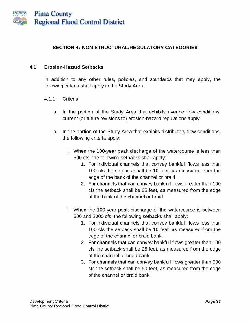
Development Criteria Pima County Regional Flood Control District
Page 33
SECTION 4: NON-STRUCTURAL/REGULATORY CATEGORIES
4.1 Erosion-Hazard Setbacks In addition to any other rules, policies, and standards that may apply, the following criteria shall apply in the Study Area.
4.1.1 Criteria
a. In the portion of the Study Area that exhibits riverine flow conditions, current (or future revisions to) erosion-hazard regulations apply.
b. In the portion of the Study Area that exhibits distributary flow conditions,
the following criteria apply:
i. When the 100-year peak discharge of the watercourse is less than 500 cfs, the following setbacks shall apply:
1. For individual channels that convey bankfull flows less than 100 cfs the setback shall be 10 feet, as measured from the edge of the bank of the channel or braid.
2. For channels that can convey bankfull flows greater than 100 cfs the setback shall be 25 feet, as measured from the edge of the bank of the channel or braid.
ii. When the 100-year peak discharge of the watercourse is between
500 and 2000 cfs, the following setbacks shall apply: 1. For individual channels that convey bankfull flows less than
100 cfs the setback shall be 10 feet, as measured from the edge of the channel or braid bank.
2. For channels that can convey bankfull flows greater than 100 cfs the setback shall be 25 feet, as measured from the edge of the channel or braid bank
3. For channels that can convey bankfull flows greater than 500 cfs the setback shall be 50 feet, as measured from the edge of the channel or braid bank.

Development Criteria Pima County Regional Flood Control District
Page 34
iii. When the 100-year peak discharge of the watercourse is between 2000 and 5000 cfs, the following setbacks shall apply:
1. For individual channels that convey bankfull flows less than 500 cfs the setback shall be 25 feet, as measured from the edge of the channel or braid bank.
2. For channels that can convey bankfull flows greater than 500 cfs the setback shall be 50 feet, as measured from the edge of the channel or braid bank.
3. For channels that can convey bankfull flows greater than 1000 cfs the setback shall be 75 feet, as measured from the edge of the channel or braid bank.
c. Alternative safe setbacks that differ from the setbacks established above
may be proposed, based upon submittal of technical justification to the floodplain management agency having jurisdiction.
d. For existing legal lots recorded prior to the adoption of this study, and
which are now, by virtue of this study, located in an adopted flow corridor within a distributary channel, the erosion-hazard setback and foundation design for any proposed structure shall be prepared by an Arizona-registered civil engineer, and shall be submitted to the local authority having floodplain management jurisdiction for review and approval.
4.1.2 Rationale In the Study Area severe erosion, both lateral and vertical, may occur over a short periods of time, as a result of a large flood; or, over a longer peroid of time as the result of a series of smaller floods. Since conventional hydraulic engineering methods do not account for erosion hazards, the local jurisdictions have established erosion-hazard setbacks along watercourses to minimize erosion damage and potential loss of life and property. These setbacks have been developed for riverine flow conditions. Approximately one-third of the Study Area (primarily the northern portion) exhibits riverine flow, and current City, County, and Town erosion-hazard regulations appear to work well in these areas. However, these regulations are not as readily applicable in distributary flow areas, like those which exist in many areas of the Lee Moore Wash Watershed.

Development Criteria Pima County Regional Flood Control District
Page 35
In distributary flow areas, water flows within, or back and forth between, multiple channels or “braids” during a single event or a series of flooding events. Typically these braids are contained within the regulatory floodplain, but they convey considerably less water than traditional riverine low-flow channels. In order to establish Development Criteria with more appropriate erosion-hazard setbacks for distributary flow areas, the following have been evaluated:
a. 100-year floodplain depths greater than 0.5 feet b. Capacity of a channel or braid, as measured by its ability to convey a
given range of discharges (Q), measured in cubic feet per second (cfs). c. Velocity of flow within a channel or braid during the 100-year flood, as
measured in feet per second (fps). d. The potential for a channel or braid to increase its flow capacity due to
geomorphic processes, such as erosion, deposition, or avulsion. e. Location of a channel or braid as to whether it is located either within or
without an adopted or revised flow corridor.
These factors have been utilized to establish a minimum lateral erosion-hazard setback from the primary bank of a channel or braid, as identified in the Criteria contained herein.
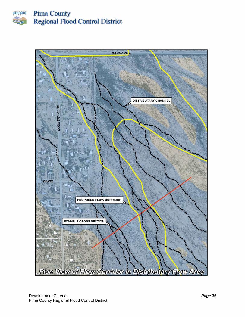
Development Criteria Pima County Regional Flood Control District
Page 36
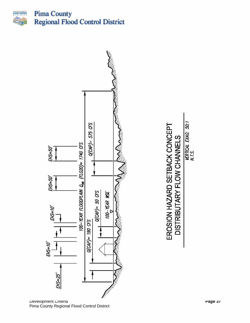
Development Criteria Pima County Regional Flood Control District
Page 37

Development Criteria Pima County Regional Flood Control District
Page 38
4.2 Flow Corridors
In addition to any other rules, policies, and standards that may apply, the following criteria shall apply in the Study Area.
4.2.1 Criteria
a. Flow corridors established and defined as part of the Lee Moore Wash
Basin Management Study shall be maintained in their natural state, except as described below.
b. Private and public development shall preserve the flow corridors identified in the Lee Moore Wash Basin Management Study to the fullest extent possible.
c. A 50-foot recreation easement may be provided on both sides of all adopted and any modified flow corridors, if required by the agency having jurisdiction.
d. Modifications to the flow-corridor width and location may be granted by the floodplain management agency having jurisdiction. Prior to approving such a modification, the jurisdictional agency shall consult with other floodplain management agencies with jurisdiction and private property owners within the Lee Moore Wash Basin Management Study area that may be impacted by the proposed modification. The purpose of the consultation is to ensure that the integrity of the backbone natural drainage infrastructure system is maintained. There are several flow-corridor modification administrative thresholds, as described below:
i. Those modifications granted by the Chief Engineer or Floodplain Administrator of the floodplain management agency having jurisdiction when (1) the modifications are made only on parcels of land which are within one political jurisdiction and for which 100% of the land owners consent to the modifications in writing, and (2) the proposed modifications result in collection and release of water that is maintained at pre-existing flow rates

Development Criteria Pima County Regional Flood Control District
Page 39
and collected and released at the same pre-development locations.
ii. Those modifications granted by the Chief Engineers or Floodplain Administrators of the floodplain management agencies having jurisdiction when (1) the modifications are made only on parcels of land which are within several political jurisdictions and for which 100% of the land owners consent to the modifications in writing, and (2) the proposed modifications result in collection and release of water that is maintained at pre-existing flow rates and collected and released at the same pre-development locations.
iii. Those modifications of a flow corridor within an adopted Special Flood Hazard area, as designated by FEMA, shall need a variance conforming to the requirements of the National Flood Insurance Program, as provided within 44CFR66. Prior to scheduling a variance hearing, the agency with jurisdiction shall consult with and obtain concurrence from the other local government agencies within the Study Area. The purpose of the consultation is to ensure that the integrity of the backbone natural drainage infrastructure system is maintained. Variances shall be filed with the Chief Engineers or Floodplain Administrators of the floodplain management agencies having jurisdiction, and shall follow the procedures outlined by each of those agencies having jurisdiction in those areas within which the proposed flow-corridor modifications lie.
e. Flow corridors may be used for non-paved, non-motorized vehicular trail use in compliance with other local, state, and federal regulations.
f. Flow corridors may be used for regional habitat restoration projects, but may not be used as Riparian Habitat Mitigation Areas.
g. Underground utility-construction activities are not allowed in flow corridors, except that generally perpendicular crossings of major utilities may be allowed if demonstrated, as necessary, for public health and safety purposes. When demonstration of need has been documented, these crossings shall comply with the “Utility Crossing Development

Development Criteria Pima County Regional Flood Control District
Page 40
Criteria for the Lee Moore Wash Basin Management Study.”
h. Roadway crossings of flow corridors should create minimal disturbance. When needed, these crossings shall comply with the “Road Crossing Development Criteria for the Lee Moore Wash Basin Management Study.”
4.2.2 Rationale
As land is developed, there is a need to identify and preserve a backbone natural drainage system for the efficient conveyance of stormwaters and floodwaters. Preservation of existing flow paths in their natural condition allows for the conveyance of post-development drainage while maintaining the natural functions of the floodplain. Current City, County and Town Floodplain Management Ordinances allow for limited encroachment into the 100-year floodplain, based on engineering analysis and compliance with other applicable ordinances. Identification and preservation of flow corridors in the watershed, prior to development, will provide a backbone natural drainage infrastructure “blueprint” for new development that will minimize future flood hazards and losses. Flow-corridor preservation, in conjunction with other drainage and environmental ordinances, will reduce development impacts and costs, and will provide environmental benefits by maintaining existing flow paths, optimizing system sediment balance, and providing continuity for wildlife corridors. The flow corridors adopted as part of this Study have been delineated using the following criteria:
a. For that portion of the Study Area located west of the Pima County
Conservation Land System boundary, flow corridors are generally identified as follows:
i. the limits of the 10-year floodplain in distributary flow areas; and ii. the floodway or primary channel bank limits, whichever is greater,
in the riverine flow areas.
b. For that portion of the Study Area located east of the Conservation Land

Development Criteria Pima County Regional Flood Control District
Page 41
System boundary, flow corridors are generally identified as the limits of the 100-year floodplain.
c. Flow Corridors must convey the 100-year peak flow for all distributary flow in the flow corridor, including any abandoned braids replaced by the flow corridor.
d. The flow corridors and their limits are graphically depicted on the Lee Moore Wash Basin Management Study Flow Corridor and Floodplain Delineation Maps.
These limits may be reduced or expanded based on current information at the time of application (See exhibits in Lee Moore Wash Basin Management Study).

Development Criteria Pima County Regional Flood Control District
Page 42
Development Criteria Pima County Regional Flood Control District
Page 43
4.3 Water Harvesting
In addition to any other rules, policies, and standards that may apply, the following criteria shall apply in the Study Area.
4.3.1 Criteria
a. Installation of water-harvesting earthworks (localized depressions,
French drains, and other small-scale water-harvesting features that facilitate the concentration and infiltration of harvested stormwater into the soil for beneficial use) is strongly encouraged throughout the Lee Moore Wash watershed at all residential and commercial sites.
b. If requested, credit for a volumetric reduction of stormwater as a result of using water-harvesting techniques shall be given by the floodplain management agency having jurisdiction.
c. Water harvesting is strongly encouraged in the rights-of-way of public roads to decrease the contribution of roadway runoff to regional stormwater volumes.
d. The size and location of water-harvesting earthworks should be determined on a site-specific basis.
e. To increase effectiveness, install multiple small earthworks throughout a site, starting at the highest elevation of the site. Use the harvested water to supplement irrigation needs of plants placed within or adjacent to the earthworks. Plants should be placed in or near earthworks based on their tolerance for temporary inundation. Earthworks placed in proximity to existing plants should be constructed to prevent disturbance of existing roots of trees and shrubs.
f. Stormwater detention basins can contain and slowly release large volumes of stormwater, and also support vegetation, making them ideal as water-harvesting structures. The functions of properly designed multi-purpose stormwater detention basins can include stormwater
Development Criteria Pima County Regional Flood Control District
Page 44
management, support of native vegetation, creation of wildlife habitat, and active and passive recreation. Multi-purpose stormwater detention basins should be designed according to guidance from relevant jurisdictions.
g. Small-scale water-harvesting earthworks shall be designed and maintained to ensure that harvested water infiltrates into the subsurface within 24 hours of catchment. Sites with clayey soils or near-surface caliche might require percolation tests to determine if water harvesting is advisable for basins deeper than 6 inches. Cost of long-term maintenance of functionality of stormwater controls should be considered when analyzing viability of decentralized stormwater management.
h. Water-harvesting earthworks shall be designed and constructed to prevent backup of pooled stormwater into onsite structures or anywhere off site.
4.3.2 Rationale Water harvesting is a technique for concentrating stormwater runoff into depressions in the soil in locations where vegetation can benefit from increased water infiltration. Water harvesting is also conducted by collecting stormwater runoff in above- or below-ground tanks for storage until later use for landscape irrigation or other beneficial purposes. From a flood-control and stormwater-management perspective, water harvesting can assist in the infiltration of stormwater runoff on individual sites, reducing offsite flows that contribute to regional stormwater management challenges. Other benefits of water harvesting accrue regionally. Harvesting the first flush of runoff from an urban site sequesters pollutants in the soil, rather than allowing it to flow into the waters of the US. Water harvesting can be an excellent tool for controlling stormwater quality. Therefore, to increase the beneficial use of water harvesting all new commercial sites, common areas of new subdivisions, public buildings, and public right-of-ways shall be strongly encouraged to be

Development Criteria Pima County Regional Flood Control District
Page 45
constructed with water-harvesting features that assist, in general terms, with meeting landscape water needs. Specific sites benefit from water harvesting through the reduction in potable water costs due to reduced potable irrigation demand. In some cases, required stormwater detention basins can be reduced in size because of increased water harvesting in other parts of the site. Given the regional and individual site benefits of water harvesting, it should be put to extensive use in the Lee Moore Wash watershed. Guidance on techniques, sizes, and functions of various water-harvesting earthworks can be found in the City of Tucson Water Harvesting Guidance Manual, which is online at: (http://dot.tucsonaz.gov/stormwater/downloads/2006WaterHarvesting.pdf), and at several websites: http://www.watershedmg.org/ and http://www.harvestingrainwater.com/ among many other sources.
4.4 Disturbance Envelopes
In addition to any other rules, policies, and standards that may apply, the following criteria shall apply in the Study Area, as justified in the rationale.
4.4.1 Criteria
a. Development is limited in regulatory floodplain areas. No more than 60
percent of the portion of the parcel in the regulatory floodplain may be permanently disturbed; and all improvements (including, but not limited to, roof-bearing structures; retention areas; cleared and grubbed areas, such as horse corrals; landscaping with permanent irrigation; and areas with impervious ground cover and/or barriers that preclude infiltration) shall be located within this area. The cap of 60 percent of disturbance area in the regulatory floodplain is adopted for drainage purposes, and does not override zoning requirements or entitlements.

Development Criteria Pima County Regional Flood Control District
Page 46
b. The full limits of the proposed disturbance in the regulatory floodplain, as provided herein by these criteria, shall be shown on the submitted site plan or plat. Areas within the 100-year floodplain, but outside the disturbance envelope, shall not be disturbed, except as outlined herein, without approval of the Floodplain Management agency having jurisdiction.
c. For the contractor’s use and for inspection purposes, prior to issuance of the building permit boundaries of the area to be disturbed must be delineated on the property with physical markers. Locations of the physical markers shall be delineated on the site plan submitted for the building permit.
d. Temporary disturbance in excess of the 60% is allowed for utility installation, temporary construction access, and temporary stockpiling of construction related materials. Revegetation of these areas is required and must be completed prior to issuance of a final certificate of occupancy. Revegetation methods shall be consistent with regulations of the floodplain management agency having jurisdiction.
4.4.2 Rationale
A disturbance envelope is the area on a single lot, within or outside of a subdivision, which may be altered from its natural state during development of the lot. The rationale for providing for limitations of the disturbance envelope is twofold.
a. The placement of fill in and disturbance of the regulatory floodplain may have adverse impacts on adjacent properties (i.e. increase in water-surface elevation, diversion of flow, increase in flow velocity, and increase in erosion).
b. The removal of vegetation and other disturbance of the natural ground results in rainfall no longer being intercepted by the native plants and soils, thus more of this rainfall becomes runoff. Also, plant roots and other biological activity associated with vegetation increase the rate at which rainfall infiltrates into the soil. The combined result of lot

Development Criteria Pima County Regional Flood Control District
Page 47
disturbance is an increase in both the magnitude and frequency of runoff from the disturbed area.
Another consequence of the disturbance of the natural areas is a disruption and partial elimination of habitat for wildlife. Preservation and maintenance of an undisturbed lot area enhances opportunities for use by wildlife.
4.5 Walls & Fences
In addition to any other rules, policies, and standards that may apply, the following additional criteria shall apply in the Study Area, as justified in the rationale.
4.5.1 Criteria
a. Prior to construction, any wall or fence proposed on a lot that is impacted
by the 100-year floodplain shall be subject to review and approval by the local authority having floodplain management jurisdiction.
b. Fences and walls are prohibited within floodways and constructed drainageways.
c. When proposed in a regulatory floodplain, only open-type fences such as pipe rail, split rail, or barbed wire shall be allowed on or within 25 feet of property boundary lines. Block walls and other fences such as chain link and chicken-wire fences, which are not considered open-type fencing, are prohibited on or within 25 feet of property boundary lines.
d. When proposed in a regulatory floodplain, chain link, chicken wire, or other fences may be allowed if the fence is 25 feet or more from all property boundary lines, the bottom of the fence is elevated to at least the base flood elevation, and the fence completely spans any low-flow wash channels.
e. When proposed in a regulatory floodplain, block walls may be allowed if the wall is 25 feet or more from all property boundary lines, is designed

Development Criteria Pima County Regional Flood Control District
Page 48
and constructed to provide at least 50% flow-through openings, and the wall avoids any low-flow wash channels.
f. When proposed in a regulatory floodplain, a solid interior “courtyard” wall may be allowed immediately downslope or upslope of the principle dwelling unit as long as the wall does not provide more than 15 feet of additional encroachment as measured perpendicular to the direction of flow, and is greater than 50 feet from any property line.
g. Other solid fences and walls proposed in a regulatory floodplain shall demonstrate to the satisfaction of the Floodplain Administrator that there is no adverse impact to neighboring properties as a result of the proposed improvement.
4.5.2 Rationale
Fences and walls can significantly obstruct flow. Consequently, construction of these improvements is prohibited within floodways and constructed drainageways, and should be avoided or minimized in regulatory floodplains. If fences or walls are necessary, certain design considerations apply, including elevating the bottom of the fence to at or above the base flood elevation within the regulatory floodplain limits, offsetting the wall or fence from the property line to allow drainage, and providing sufficient flow-through openings in otherwise solid walls. Fences and walls that cross natural washes, channels, or flow paths shall be elevated to pass bankfull flows without obstruction, and should provide openings to convey the 100-year flood with no adverse offsite impacts. Solid perimeter walls should be set back from property lines to provide flow conveyance between lots, or should be designed to pass drainage (accounting for blockage by vegetation or debris and scour), with no adverse impacts on neighboring properties. In other words, it must be demonstrated to the satisfaction of the Floodplain Administrator that there is no increase in peak discharge, flow depth, flow velocity, or flow diversion resulting from the proposed improvement(s).
Development Criteria Pima County Regional Flood Control District
Page 49
SECTION 5: MAINTENANCE
5.1 Inspection and Maintenance Practices In addition to any other rules, policies, and standards that may apply, the following criteria shall apply in the Study Area.
5.1.1 Criteria All Facilities: The following shall be addressed in a maintenance plan:
a. Routine (quarterly) inspection and maintenance/cleanup for activities such as trash removal, fence repair, landscaping etc.
b. Periodic (annual) inspection and maintenance/repairs to ensure the
structural integrity of the facility, as well as to insure physical integrity relative to aggradation or degradation, vandalism, vegetative invasion, etc.
c. Post-storm or flooding maintenance/repairs to address significant
aggradation and degradation episodes, damage to the structural integrity of the facility, or maintenance/ repairs, as warranted, to restore the flood-control functionality.
Inspection and Maintenance responsibility: When drainage infrastructure is dedicated to the public, it shall be the responsibility of the local jurisdiction having authority to perform the inspection and maintenance responsibilities described herein. When the drainage infrastructure is privately maintained, the entity that has inspection and maintenance responsibility shall be established at the time of review of the Development Plan or Subdivision Plat. Also, a mechanism to ensure adequate resources for routine and annual inspections and any necessary maintenance shall be provided and disclosed in the Conditions, Covenants, and Restrictions, and/or on the Plan or Plat, as appropriate.
Development Criteria Pima County Regional Flood Control District
Page 50
Stormwater Detention Basins (including associated landscaping): Routine maintenance activities will be based on the results of the required quarterly inspections of stormwater detention basins, and associated landscaping, if applicable. The floors of stormwater detention basins will be cleaned of all trash and debris that can clog outlet structures during floods. Outlet structures will also be inspected and cleaned of any debris on a regular and routine basis. Landscaping shall be trimmed to design levels, and trimmings shall be disposed of at an approved facility (not in conveyance channels or stormwater detention basins). Gravel or decomposed granite will be maintained at design levels, which may include sweeping and replacement to assure adequate functionality. Periodic Maintenance for Stormwater Detention Basins: Routine inspection and maintenance activities will be based on the results of the required annual inspections. If regular and routine inspections reveal that no damage has occurred from minor storms or vandalism, then major maintenance need only be performed at 3-year intervals, or longer if justified.
a. Basin Bottom. Measurements of basin floor elevations will be taken if the inspection reveals signs of sediment aggradation or degradation. The elevations will then be compared to the design and as-built condition. If existing elevations are found to be, on average, more than one foot different than design elevations, the floodplain management agency having jurisdiction or a designated responsible party will be notified immediately for a determination as to what course of action, if any, is needed.
b. Basin Side-Slopes. Detention basin side-slopes will be inspected for signs of rill erosion, embankment cracking, or sloughing due to slope instability. If the erosion, cracking, or sloughing is minor, then the slopes may be re-graded to re-establish the design grades. If major grading is needed, and it will significantly disturb established vegetation, then the floodplain management agency having jurisdiction or a designated responsible party will be notified immediately for a determination as to what course of action, if any, is needed.

Development Criteria Pima County Regional Flood Control District
Page 51
c. Other. A visual inspection will be completed of all surface structural
components including, but not limited to, inlet and outlet structures, scour protection and erosion-control, access areas, and recreational facilities. They will be evaluated for signs of distress, sulfate attack, cracking, differential settlement, tilting, surface-water ponding near the foundations, or unauthorized modifications. Minor repairs will be made, as needed, but before any major repairs are conducted the floodplain management agency having jurisdiction or a designated responsible party will be notified immediately for a determination as to what course of action, if any, is needed.
The results of all Periodic Maintenance Activities will be documented and available for review by both the floodplain management agency having jurisdiction and the designated responsible party. After completion, all maintenance activities performed as a result of the annual inspection will be photographed, and a description of the activity and its costs will be documented and filed with the floodplain management agency having jurisdiction and the designated responsible party. Post-Storm Maintenance for Stormwater Detention Basins: Post-storm inspections should be performed as soon as it is feasibly possible to do so after significant storms have subsided. Although designed for 100-year flow conditions, the system is still susceptible to damage during more frequent flow events. A post-storm maintenance inspection shall be completed after the occurrence of a rainfall of 1.5 inches in 3 hours, or similar event, regardless of any reported flooding. During prolonged storm events, daily monitoring of the flood-control structures, particularly the stormwater detention basins, should be conducted. Online precipitation gauge data is available from the Pima County Regional Flood Control District to assist in evaluating rainfall events. The results of all post-storm maintenance will be documented and available for review by both the floodplain management agency having jurisdiction and the designated responsible party. If major damage has occurred due to a flow event, then the floodplain management agency having jurisdiction or a designated responsible party will be notified immediately for a determination as to what
Development Criteria Pima County Regional Flood Control District
Page 52
course of action, if any, is needed. Annual Inspections: Annual inspections are intended to assess the system's operating condition, and should identify larger-scale repair and maintenance items. These inspections shall be performed by an Arizona registered Civil Engineer, who shall provide a certification letter indicating that the maintenance is consistent with the approved maintenance plan and the criteria in this document. If this is not the case, then the appropriate jurisdiction shall be immediately notified. These inspections are intended to evaluate how the facilities have changed from their as-built condition. Detailed photo documentation provides a permanent record of changing conditions, and is strongly recommended. For example, cracks can be carefully monitored by placing a scale/ruler within a photo. These inspections should typically be performed mid-year, prior to the monsoon season after high spring flows have subsided. Annual inspection records should be maintained by the floodplain management agency having jurisdiction or a designated responsible party. Key items to be evaluated include:
a. Crest Height: monitor crest elevation of any embankments to ensure design freeboard height is maintained.
b. Embankment Integrity: monitor and address cracking of embankments
to mitigate piping through the embankment or foundation, or slope instability.
c. Vegetation: ensure vegetative cover is maintained to reduce erosion
during flood events, while maintaining size-control in order to avoid root damage.
d. Embankment Crests: ensure all-weather driving surface is maintained
along embankment crest, for maintenance purposes. e. Erosion: monitor areas for the development of erosion or undercutting of
any flood-control structures.

Development Criteria Pima County Regional Flood Control District
Page 53
f. Sediment Build-Up: monitor the depth of sediment deposition in the base of the culvert, channel, or stormwater detention basin.
g. Rodent Activity: monitor rodent activity (e.g., burrows) which may increase the potential for embankment foundation piping.
h. Structural Integrity: monitor the condition of all erosion-control walls for
signs of distress, sulfate attack, cracking, differential settlement, tilting, surface-water ponding near the foundations, or any unauthorized modifications.
Post-Storm Inspections: Post-storm inspections should be performed as soon as possible after flood conditions have subsided. Although flood-control systems are usually designed for 100-year flow conditions, they may incur damage during more frequent flow conditions. Post-storm inspection records should be kept and maintained by the floodplain management agency having jurisdiction or a designated responsible party. Items to be inspected after storm flows have subsided are listed below:
a. Vegetation: high-flow erosion damage
b. Earthen Fill: slope and bank-protection integrity, and seepage through the embankment face
c. Culverts: culverts to ensure free-flowing conditions
d. Embankment crests: in event of overtopping, check that concentrated flow areas do not develop
e. Erosion: monitor the improvements for indications of erosion
f. Sediment Build-Up: monitor the depth of sediment deposition at the base of the channel
Development Criteria Pima County Regional Flood Control District
Page 54
Field-inspection reports shall include, at a minimum:
a. A description of the facility’s current condition, for the entire length of the improvements. It is important to note areas where erosion is, or will likely become, a problem.
b. A description of the existing vegetation, if any, and the loss of any
vegetation, together with comments and/or recommendations regarding the need for the addition and/or removal of any vegetation that may impede the flow within the wash, or which may need to be replaced for erosion control.
c. Comments and/or notes, with photographs where necessary, of unauthorized uses of the facility, unauthorized dumping, and/or damage to the system components.
d. Comments and/or notes, with photographs if necessary, of any damage
to any culverts, irrigation pipes, utilities, etc. e. Recommendations for remedial actions needed to preserve the integrity
of the facility and its designated function. f. The report shall note any change of land use adjacent to the wash. g. Inspect, and include comments in the report, regarding existing utilities in
or adjacent to the wash that may have been impacted by a storm event. h. Inspect for sediment, silt, debris, trash, or deleterious material. Where
depths of sedimentation are excessive, where debris causes flow restrictions, or where trash has accumulated, removal shall be required.
A field-inspection report shall be completed; and, if requested by a complaint, the floodplain management agency having jurisdiction can request a field-inspection report within 15 days of receipt of said complaint. A field-inspection report shall be completed on a daily basis during times of high flow. Immediately after the waters have receded, a field-inspection shall be conducted as described herein.

Development Criteria Pima County Regional Flood Control District
Page 55
5.1.2 Rationale The purpose of this Development Criteria is to provide procedural guidelines for a systematic approach to monitoring, operating, and maintaining regional stormwater detention basins and other flood-control facilities in the Study Area, for the overall purpose of enhanced public safety. Currently there are no local guidelines or criteria outlined or documented anywhere regarding inspection and maintenance procedures, and this Development Criteria is being written to help rectify this situation. Monitoring, operating, and inspection/maintenance plans should be commensurate with the scale and complexity of the improvement. Basic guidelines are provided herein; however, specific plans should be developed for each facility, as warranted. The importance of conducting routine inspections as part of any operating plan cannot be overstated, as early detection of gradual changes can reduce overall maintenance costs and the likelihood of major failure of the facility in the future. Channels, levees, stormwater detention basins, culverts and erosion-control walls in the Study Area shall be inspected at least once a year. During high flows, facility conditions shall be routinely monitored each day, and thoroughly inspected after the flows subside. It is anticipated that multiple agencies will be responsible for funding the monitoring, operating, and maintenance activities in the Study Area. These agencies will likely include the following:
a. Town of Sahuarita b. Pima County Regional Flood Control District c. City of Tucson d. Homeowner Associations e. Special Districts Maintenance
Operating and inspection/maintenance activities shall be performed by the floodplain management agency having jurisdiction, or a designated responsible party. All records, including inspection, maintenance, and flow monitoring, shall be kept on file with the floodplain management agency having jurisdiction.

Development Criteria Pima County Regional Flood Control District
Page 56
SECTION 6: SUMMARY
6.1 Summary The major components of future alternatives involve generating Development Criteria, intended to provide regulations and guidelines for future development within the area, and the delineation of a network of flow corridors throughout the study area. Public education and outreach, as well as recommending modifications or changes to future roadway alignments to avoid floodprone areas, were also recommended alternatives associated with the future analyses. The Public Involvement Plan for this project was designed to fulfill the promise of “consult” on the International Association for Public Participation (IAP2) Spectrum of Public Participation: to keep the public informed, listen to and acknowledge concerns and aspirations, and provide feedback on how the public input was considered in the decision. The goal of the plan was to bring more information into the study for consideration, provide additional perspectives on alternatives in order to reach the best outcome, and greater public understanding, support and acceptance of the study and its final outcome. The plan outlined 12 stakeholder workgroup meetings, 12 individual stakeholder meetings and six public meetings (three rounds of two meetings). The actual effort materialized as seven workgroup meetings (three rounds of two meetings - one for public agencies and one for private organizations; the final meeting combined both public and private), seven stakeholder meetings (one each with Diamond Ventures, Pima Association of Governments, Arizona State Land Department, Southern Arizona Home Builders Association and Tucson Water, and two with City of Tucson staff), three rounds of two public meetings (each round included a meeting on both the east and west sides of the study area, for a more inclusive approach), and an additional two (2) public meetings were held in the Summit area to address specific flooding and drainage needs in that area. Additionally, 10 focus group meetings were held with staff from both public agencies and private organizations to collaboratively discuss and edit the Development Criteria for the LMWBMS. The Development Criteria identified herein are part of the non-structural Recommended Alternative of the LMWBMS. Adherence to these development criteria will lessen the adverse impacts of urbanization and decrease the cost of

Development Criteria Pima County Regional Flood Control District
Page 57
flooding for the public and private sectors. Over the past few decades that the County has been managing floodplain areas, it has become apparent that there is a lack of tools to adequately manage individual lot development, especially in distributary flow areas. In addition, as part of this basin management study, it was determined that Development Criteria which focused both on single-family development on individual lots, standard subdivisions and/or large master planned developments could reduce flood and related damage within the Lee Moore Wash watershed. As a result, a major component of the study presented herein establishes preferred, natural flow corridors to convey flows within these areas, as illustrated in Exhibit C. Approximately 48% of the LMWBMS area is owned by the state of Arizona and managed by the Arizona State Land Department (ASLD). ASLD manages lands in compliance with the Enabling Act, the Arizona Constitution, and Arizona Revised Statutes Title 37 which require that State Trust Lands be managed in the best interests of the designated State Trust beneficiaries. As such, certain elements of the Development Criteria may not have the same regulatory compliance authority with regards to State Trust Lands as it does to land owned by others. The principles, policies and practices contained within the Design Criteria provide a useful method for insuring a consistent and comprehensive approach to floodplain management within the Study area; therefore it is in the best interest of all land owners and jurisdictions to comply with these Development Criteria to the fullest extent possible.
Development Criteria Pima County Regional Flood Control District
Page 58
SECTION 7: APPENDICES
7.1 Authority
7.1.1 Arizona Revised Statutes Arizona Revised Statutes Title 48 - Special Taxing Districts. http://www.azleg.gov/ArizonaRevisedStatutes.asp?Title=48
7.2 Drainage and Development Regulations
7.2.1 City of Tucson City of Tucson Standard Manual for Drainage Design and Floodplain Management in Tucson, Arizona, December 1989, Revised, July 1998. http://tdotmaps.transview.org/mandr/Download/
7.2.2 Pima County Regional Flood Control District Pima County Title 16, Floodplain and Erosion Hazard Management Ordinance. http://rfcd.pima.gov/rules/
7.2.3 Town of Sahuarita Sahuarita Town Code, Title 14, Floodplain Management and Right-of-Way. http://www.codepublishing.com/AZ/Sahuarita/Sahuarita14/Sahuarita1405.html#14.05

Appendix F Stakeholder Involvement Flow Chart
LEE MOORE WASH BASIN MANAGEMENTLEE MOORE WASH BASIN MANAGEMENT STUDYSTUDYLEE MOORE WASH BASIN MANAGEMENT LEE MOORE WASH BASIN MANAGEMENT STUDYSTUDY
STAKEHOLDER INVOLVEMENT FLOW CHART
STEP 1
INFORM
STEP 2
INVOLVE
STEP 3
INCLUDE
DEVELOP STAKEHOLDER DEVELOP STAKEHOLDER DATABASEDATABASE
DEVELOP ALTERNATIVES DEVELOP ALTERNATIVES WITH STAKEHOLDER INPUTWITH STAKEHOLDER INPUT
DEVELOP IMPLEMENTATION DEVELOP IMPLEMENTATION PLAN WITH STAKEHOLDERSPLAN WITH STAKEHOLDERS
• • First ContactFirst Contact•• Identify IssuesIdentify Issues• • WorkgroupsWorkgroups
• • Interactive Alternative Interactive Alternative DevelopmentDevelopment
•• Individual Meetings Individual Meetings for Specific Sites/Issuesfor Specific Sites/Issues
• • Concept Concurrence on Concept Concurrence on Recommended AlternativesRecommended Alternatives
• Conceptual Cost Sharing Opportunities • Conceptual Cost Sharing Opportunities • Workgroups• Workgroups
IMPLEMENTATION PLAN
for Specific Sites/Issuesfor Specific Sites/Issues•• WorkgroupsWorkgroups
IMPLEMENTATION PLAN
• Potential Cost-Share Opportunities Ph i /Ti i R d ti• Phasing/Timing Recommendations
• Development Criteria

Appendix G Stakeholder Database

LeeMooreWashBasin, PUBLIC SECTOR, DATA BASE
Attended 10/12/06
Sir Title First Name Last Name Company/Agency Title Business Address City State Postal Code Business Fax Business
Phone E-mail Address
Mr. Greg FizerArizona Department of Corrections, ASPC -
TucsonWarden 10000 S. Wilmot Rd.
PO Box 24400 Tucson AZ 85734 574-7300 574-0024
Mr. Greg Gentsch Arizona Department of Transportation 1221 S. Second Ave. Tucson AZ 85713 903-9969 388-4262 [email protected]
Mr. Michael Finkelstein Center for Biological Diversity Executive Director PO Box 710 Tucson AZ 85702 623-5252 ext.
Ms. Andy McGovern City of Tucson Department of Transportation 201 N. Stone Ave. 3rd Floor Tucson AZ 85701 791-4251 [email protected]
Mr. Jim Glock City of Tucson Department of Transportation Director 201 N. Stone Ave. 6th Floor Tucson AZ 85701 791-5641 791-4371 [email protected]
Mr. Frank Sousa City of Tucson Department of Transportation 201 N. Stone Ave. 3rd Floor Tucson AZ 85701 791-3115 x
Mr. Craig Gross City of Tucson Development Services Deputy Director 201 N. Stone Ave. Tucson AZ 85701 791-5550
Mr. Joanne HershenhornCity of Tucson Department
of Urban Planning and Design
Lead Planner 149 N. Stone Ave., 4th Floor PO Box 27210 Tucson AZ 85726-27210 791-4505 [email protected]
Mr. Jim VogelsbergCity of Tucson
Development Services, Floodplain
201 N. Stone Ave., 1st Floor Tucson AZ 85701 791-5550 [email protected]
Mr. Andrew Singelakis City of Tucson Department of Transportation Deputy Director 201 N. Stone Ave., 6th Floor Tucson AZ 85701 791-4522 791-4505 [email protected]
Mr. Andy Squire City of Tucson, Ward 4 Chief of Staff 8123 E. Poinciana Dr. Tucson AZ 85730 [email protected]
Mr. Abe Marques City of Tuscon, Ward 5 Administrative Assistant 4300 E. Park Ave. Tucson AZ 85714 [email protected]
LeeMooreWashBasin, Stakeholder Database 1/17/2011

LeeMooreWashBasin, PUBLIC SECTOR, DATA BASE
Attended 10/12/06
Sir Title First Name Last Name Company/Agency Title Business Address City State Postal Code Business Fax Business
Phone E-mail Address
Keith Graves Coronado National Forest, Nogales Ranger District 303 Old Tucson Rd. Nogales AZ 85621 281-2396 281-2296
Federal Bureau of Prisons, FCI Tucson 8901 S. Wilmot Rd. Tucson AZ 85706 574-7341 574-7100 tcn/[email protected]
Friends of the Santa Cruz River PO Box 4275 Tubac AZ 85646 398-9093
Mr. Gary Hayes Pima Association of Governments Executive Director 177 N. Church Ave., Ste. 405 Tucson AZ 85701 620-6981 792-1093 [email protected]
Honorable Ramón Valadez Pima County Board of
Supervisors, District 2 County Supervisor 130 W Congress St, 11th Floor Tucson AZ 85701 884-1152 740-8126 [email protected]
Honorable Ray Carroll Pima County Board of
Supervisors, District 4 County Supervisor 130 W Congress St, 11th Floor Tucson AZ 85701 740-2721 740-8094 [email protected]
Ms. Mary Hamilton Pima County Regional Wastewater
Manager,Planning Division 201 N. Stone Avenue Tucson AZ 85701-1207 620-0135 740-6641 [email protected]
Mr. Paul Bennett Pima County DOT Project Manager 201 N. Stone Avenue,3rd Floor Tucson AZ 85701-1207 838-7537 740-6408 [email protected]
Mr. Rick Ellis Pima County Department of Transportation 201 N. Stone Ave., 3rd Floor Tucson AZ 85701 620-1933 740-6410 [email protected]
Mr. Rafael PayanPima County Natural
Resources, Parks and Recreation
Director 3500 W. River Rd. Tucson AZ 85741 877-6006 877-6000 [email protected]
Ms. Carla BlackwellPima County Planning and
Development Services Department
Deputy Director 201 N. Stone Ave., 1st Floor Tucson AZ 85701 740-6878 740-6506 [email protected]
Mr. Michael Gritzuk Pima County Wastewater Management Director 201 N. Stone Ave., 8th Floor Tucson AZ 85701 620-0135 740-6500
LeeMooreWashBasin, Stakeholder Database 1/17/2011

LeeMooreWashBasin, PUBLIC SECTOR, DATA BASE
Attended 10/12/06
Sir Title First Name Last Name Company/Agency Title Business Address City State Postal Code Business Fax Business
Phone E-mail Address
Ms. Sue Clark Pima Trails Association P.O. Box 35007 Tucson AZ 85740 887-0921 577-7919 [email protected]
Mr. Fred Huff Sahuarita Unified School District
Transportation Manager 350 W Sahuarita Rd Green
Valley AZ 85629 393-7033 625-3502 x 1160 [email protected]
Dr. Jay St. John Sahuarita Unified School District Superintendent 350 W Sahuarita Rd Green
Valley AZ 85629 625-4609 625-3502 [email protected]
Mr. Paul Sweum San Xavier District of Tohono O'Odham Nation Planning Director 2018 W San Xavier Rd Tucson AZ 85746 294-0613
Ms. Janice Przybyl Sky Island Alliance PO Box 41165 Tucson AZ 85717 624-7083 x 203 [email protected]
Mr. Jon BakerSouthwest Fair
Commission (Pima County Fairgrounds)
Executive Director 11300 S. Houghton Rd. Tucson AZ 85747 762-5005 762-9100 [email protected]
Ms. Roxana Sanders Summit View Elementary School Principal 1900 E Summit St Tucson AZ 85706 545-3816 545-3800 [email protected]
Mr. Raul Bejarano Sunnyside Unified School District Superintendent 2238 E Ginter Rd Tucson AZ 85706 545-2121 545-2025 [email protected]
Mr. John Neunuebel Town of Sahuarita Planning and Zoning Planning Director 725 W Via Rancho, Box 879 Sahuarita AZ 85629 625-9879 648-
1972x119 [email protected]
Mr. Bob Wech Town of Sahuarita Public Works
PW Director/Town Engineer 725 W Via Rancho, Box 879 Sahuarita AZ 85629 625-9879 648-1972 x
Ms. Sonja Macys Tucson Audobon Society Executive Director 300 E University, Ste 120 Tucson AZ 85705 623-3476 622-5622 [email protected]
Mr. Bob Mendoza Union Pacific Railroad 1255 S. Campbell Ave. Tucson AZ 85711 322-2631275-
5323/629-2120
LeeMooreWashBasin, Stakeholder Database 1/17/2011
LeeMooreWashBasin, PUBLIC SECTOR, DATA BASE
Attended 10/12/06
Sir Title First Name Last Name Company/Agency Title Business Address City State Postal Code Business Fax Business
Phone E-mail Address
Mr. Mark HeitlingerUniversity of Arizona, Santa
Rita Experimental Range and Wildlife Area
Manager PO Box 1389 Green Valley AZ 85622 625-2121 [email protected]
Mr. Calvin Baker Vail School District Superintendent P.O. Box 800 Vail AZ 85641 762-2001 762-2004 [email protected]
Mr. Albert Flores Vail School DistrictDirector of
Facilities and Transportation
P.O. Box 800 Vail AZ 85641 762-2001 762-2050 [email protected]
Mr. John Holt Western Area Power Authority
Environmental Manager 12155 W. Alameda Parkway Lakewood CO 80228-8213 602-352-
2592 [email protected]
Mr. Brian Cosson Arizona Dept. of Water Resources NFIP Coordinator 500 N. Third Street Phoenix AZ 85004 602-417-2423 602-417-
2445 [email protected]
Mr. Greg Gamble The Nature ConservancyRapidly Urbanizing
Areas Project Director
602-322-6987 602-712-0059 [email protected]
Mr. Andy Dinauer City of Tucson, Department of Transportation
Engineering Administrator 201 N. Stone Ave., 3rd Floor Tucson AZ 85701 [email protected]
Mr. Steve Pageau City of Tucson, Department of Transportation Deputy Director 201 N. Stone Ave., 6th Floor Tucson AZ 85701 [email protected]
Ms. Karen Masbruch City of Tucson Manager's Office
Assistant City Manager 255 W. Alameda, 10th Floor Tucson AZ 85701 [email protected]
Mr. Albert Elias City of Tucson, Department of Urban Planning Design Director 345 E. Toole Ave. Tucson AZ 85701 [email protected]
Ms. Leslie LibertiCity of Tucson, Office of
Conservation and Sustainable Development
345 E. Toole Ave. Tucson AZ 85701 [email protected]
Mr. Ernie Duarte City of Tucson, Development Services
Department Director 201 N. Stone Ave., 2nd Floor Tucson AZ 85701 [email protected]
LeeMooreWashBasin, Stakeholder Database 1/17/2011
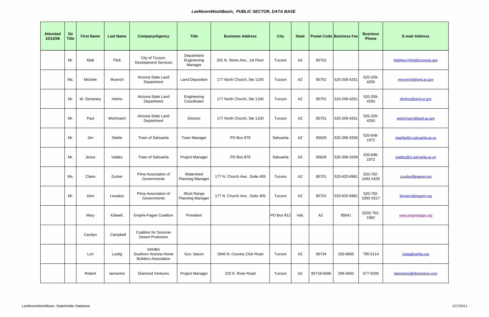
LeeMooreWashBasin, PUBLIC SECTOR, DATA BASE
Attended 10/12/06
Sir Title First Name Last Name Company/Agency Title Business Address City State Postal Code Business Fax Business
Phone E-mail Address
Mr. Matt Flick City of Tucson, Development Services
Department Engineering
Manager201 N. Stone Ave., 1st Floor Tucson AZ 85701 [email protected]
Ms. Michele Muench Arizona State Land Department Land Deposition 177 North Church, Ste 1100 Tucson AZ 85701 520-209-4251 520-209-
4250 [email protected]
Mr. W. Dempsey Helms Arizona State Land Department
Engineering Coordinator 177 North Church, Ste 1100 Tucson AZ 85701 520-209-4251 520-209-
4250 [email protected]
Mr. Paul Wichmann Arizona State Land Department Director 177 North Church, Ste 1100 Tucson AZ 85701 520-209-4251 520-209-
4250 [email protected]
Mr. Jim Stahle Town of Sahuarita Town Manager PO Box 879 Sahuarita AZ 85629 520-399-3330 520-648-1972 [email protected]
Mr. Jesus Valdez Town of Sahuarita Project Manager PO Box 879 Sahuarita AZ 85629 520-399-3339 520-648-1972 [email protected]
Ms. Claire Zucker Pima Association of Governments
Watershed Planning Manager 177 N. Church Ave., Suite 405 Tucson AZ 85701 520-620-6981 520-792-
1093 X435 [email protected]
Mr. John Liosatos Pima Association of Governments
Short Range Planning Manager 177 N. Church Ave., Suite 405 Tucson AZ 85701 520-620-6981 520-792-
1093 X517 [email protected]
Mary Kidwell, Empire-Fagan Coalition President PO Box 812 Vail, AZ 85641 (520) 762-1962 www.empirefagan.org
Carolyn Campbell Coalition for Sonoran Desert Protection
Lori LustigSAHBA
Southern Arizona Home Builders Association
Gov. liaison 2840 N. Country Club Road Tucson AZ 85734 326-8665 795-5114 [email protected]
Robert Iannarino Diamond Ventures Project Manager 220 E. River Road Tucson AZ 85718-6586 299-5602 577-0200 [email protected]
LeeMooreWashBasin, Stakeholder Database 1/17/2011
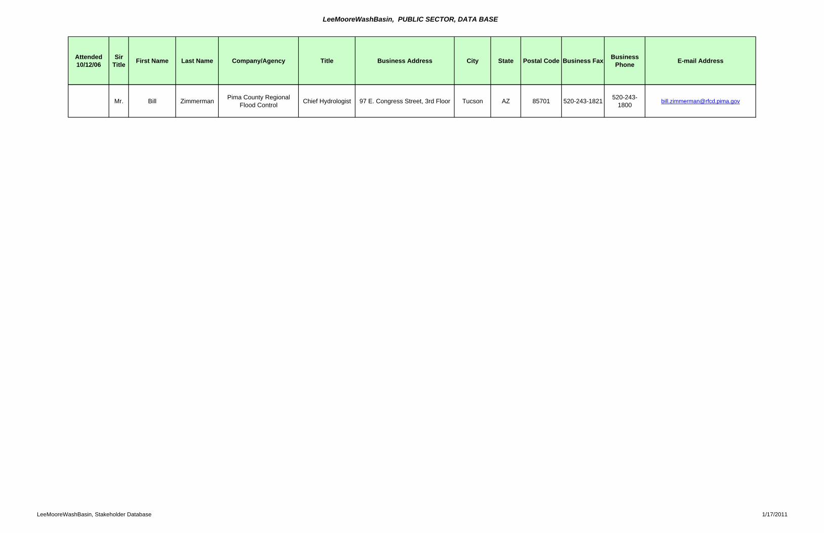
LeeMooreWashBasin, PUBLIC SECTOR, DATA BASE
Attended 10/12/06
Sir Title First Name Last Name Company/Agency Title Business Address City State Postal Code Business Fax Business
Phone E-mail Address
Mr. Bill Zimmerman Pima County Regional Flood Control Chief Hydrologist 97 E. Congress Street, 3rd Floor Tucson AZ 85701 520-243-1821 520-243-
1800 [email protected]
LeeMooreWashBasin, Stakeholder Database 1/17/2011