legal department american electric...
TRANSCRIPT

Legal Department American Electric Power1 Riverside PlazaColumbus, OH 43215-2373AEP.com
December 4, 2017
Chairman Asim Z. HaqueOhio Power Siting Board180 East Broad StreetColumbus, Ohio 43215
Re: PUCO Case No. 17-0806-EL-BLNIn the Matter of the Letter of Notification for the Heppner Station Project
Dear Chairman Haque,
Attached please find a copy of the Letter of Notification (LON) for the above-captioned project (“Project”) by AEP Ohio Transmission Company, Inc. This filing and notice is in accordance with O.A.C. 4906-6-05
A copy of this filing will also be submitted to the executive director or the executive director’s designee. A copy will be provided to the Board Staff, including an electronic copy.
If you have any questions, please do not hesitate to contact me.
Respectfully submitted,
/s/ Christen BlendChristen Blend (0086881), Counsel of RecordHector Garcia (0084517)Counsel for AEP Ohio Transmission Company, Inc.
cc: Jon Pawley, OPSB Staff
Hector GarciaChristen M. BlendSenior Counsel –Regulatory Services(614) 716-3410 (P)(614) 716-1915 (P)[email protected]@aep.com

LETTER OF NOTIFICATION FOR Heppner Station Project
PUCO Case No. 17-0806-EL-BLN
Submitted to: The Ohio Power Siting Board Pursuant to Ohio Administrative Code Section 4906-6-05 Submitted by: AEP Ohio Transmission Company, Inc.
December 4, 2017

AEP Ohio Transmission Company, Inc. December 4, 2017
Heppner Station Project 17-0806-EL-BLN 1
LETTER OF NOTIFICATION FOR HEPPNER STATION PROJECT December 4, 2017
LETTER OF NOTIFICATION AEP Ohio Transmission Company, Inc.’s
Heppner Station Project 4906-6-05 AEP Ohio Transmission Company, Inc. (“AEP Ohio Transco”) is providing the following information to the Ohio Power Siting Board (“OPSB”) in accordance with the accelerated application requirements of Ohio Administrative Code Section 4906-6-05. 4906-6-05(B) General Information B(1) Project Description The name of the project and applicant's reference number, names, and reference number(s) of resulting circuits, a brief description of the project, and why the project meets the requirements for a Letter of Notification. AEP Ohio Transco has identified the need to construct the Heppner Station Project (the “Project”) in Coal Township, Jackson County, Ohio. The Project consists of constructing a new switch station that will accept a third transmission source into the Lick-Ross 69 kilovolt (“kV”) circuit from the 138/69 kV transformer at the proposed Rhodes Substation. The station is being constructed as a three (3) -circuit breaker ring bus configuration. This configuration is very reliable, as no outages to any of the three (3) transmission lines are required to perform circuit breaker maintenance. The Project will be constructed on a property currently owned by the Pearl Jenkins Revocable Trust Successor by Lorrie Perry located along Prices Switch Road between OH-93 and Orville Brown Road. The location of the property (the “Project Area”) is shown on Figure 1.1 in Appendix A. The property to be sub-divided for the purchase by AEP Ohio Transco is an open/scrub-shrub lot comprising approximately 4o acres in size. The portion of this lot to be purchased by AEP Ohio Transco is approximately 5.0 acres in size. Figures 1.2 and 1.3 in Appendix A show the general location of the proposed Heppner Station within the Project Area. The Project meets the requirements for a Letter of Notification (“LON”) because it is within the types of projects defined by Item (3) of Appendix A to O.A.C. 4906-1-01, Application Requirement Matrix For Electric Power Transmission Lines:
(3) Constructing a new electric power transmission substation.

AEP Ohio Transmission Company, Inc. December 4, 2017
Heppner Station Project 17-0806-EL-BLN 2
LETTER OF NOTIFICATION FOR HEPPNER STATION PROJECT December 4, 2017
B(2) Statement of Need If the proposed project is an electric power transmission line or natural gas transmission line, a statement explaining the need for the proposed facility. The Heppner Station is being established to accept the third transmission source into the Lick-Ross 69 kV circuit from the 138/69 kV transformer at the proposed Rhodes Substation. This station will operate as a transmission hub for Jackson County, providing more flexibility for the electrical system in the area by enabling automatic switching between the three (3) available transmission sources depending on system conditions. This project has been submitted to PJM as a baseline project under PJM reference number b2885.3 B(3) Project Location The applicant shall provide the location of the project in relation to existing or proposed lines and substations shown on an area system map of sufficient scale and size to show existing and proposed transmission facilities in the project area. Figures 1.2, 1.3, and 1.4 in Appendix A show the location of the Project in relation to other existing AEP Ohio Transco transmission lines. B(4) Alternatives Considered The applicant shall describe the alternatives considered and reasons why the proposed location or route is best suited for the proposed facility. The discussion shall include, but not be limited to, impacts associated with socioeconomic, ecological, construction, or engineering aspects of the project. A total of three (3) sites were considered for the Project, each of which are discussed in detail below. Alternative 1 is also located along the existing Lick-Ross 69 kV line, approximately 500 feet north of Prices Switch Road. This alternative would require the purchase of a 5.0-acre lot from a 37.1-acre parcel of land. The closest residences to Alternative 1 are approximately 1,000 feet to the southeast and 1,000 feet to the southwest. This alternative would utilize part of an existing access road coming off Prices Switch Road. Current land use is successional herbaceous and scrub-shrub habitat within a previously disturbed property, with deciduous forested areas to the north and east. One scrub-shrub wetland and one intermittent stream were identified immediately adjacent to Alternative 1. Minimal tree clearing would be required. This alternative would be constructed along a gentle side slope, which should not require excessive grading. Alternative 2 is located approximately 200 feet south of the existing Lick-Ross 69 kV line and approximately 300 feet north of Prices Switch Road. This alternative would require the purchase of a 5.0-acre lot from a 37.1-acre parcel of land. The closest residence to Alternative 2 is approximately 400 feet to the south. This alternative would require the shortest access road coming off Prices Switch Road. Current

AEP Ohio Transmission Company, Inc. December 4, 2017
Heppner Station Project 17-0806-EL-BLN 3
LETTER OF NOTIFICATION FOR HEPPNER STATION PROJECT December 4, 2017
land use is successional herbaceous and scrub-shrub habitat within a previously disturbed property, with deciduous forested areas to the east and south. While no ecological constraints were identified for this alternative, it would require more extensive tree clearing along Prices Switch Road and additional transmission lines from the Lick-Ross 69 kV line. This alternative would be constructed along a steep side slope, which would require excessive grading. Alternative 3 is located along the existing Lick-Ross 69 kV line, approximately 1,200 feet southwest of Eisnaugle Hollow Road and 2,000 feet north of Prices Switch Road. This alternative would require the purchase of a 5.0-acre lot from an 83.1-acre parcel of land. The closest residence to Alternative 3 is approximately 1,000 feet to the northeast. This alternative would require a lengthy access road coming off Eisnaugle Hollow Road to the northeast or Prices Switch Road to the south. Current land use is open herbaceous with deciduous forested areas to the east, west, and south. One NWI-mapped wetland and one USGS 7.5-minute mapped intermittent stream were identified to the south. Tree clearing, if required, would be minimal. This alternative would be constructed on a narrow ridge top, which may require excessive grading. After a comparison of all three (3) sites, Alternative 1 was chosen as the proposed site for the Project due to its close proximity to the existing Lick-Ross 69 kV line and a reduced potential for engineering constraints. Additionally, Alternative 1 is among the furthest from residences at approximately 1,000 feet to the nearest residence. This site will also utilize part of an existing access road.

AEP Ohio Transmission Company, Inc. December 4, 2017
Heppner Station Project 17-0806-EL-BLN 4
LETTER OF NOTIFICATION FOR HEPPNER STATION PROJECT December 4, 2017
B(5) Public Information Program The applicant shall describe its public information program to inform affected property owners and tenants of the nature of the project and the proposed timeframe for project construction and restoration activities. The Project will be located on property currently owned by Pearl Jenkins Revocable Trust Successor by Lorrie Perry, approximately 5.0 acres of which will be purchased by AEP Ohio Transco. AEP Ohio Transco informs affected property owners and tenants about its projects through several different mediums. Within seven (7) days after filing this LON, AEP Ohio Transco will issue a public notice in a newspaper of general circulation in the Project Area. The notice will comply with all requirements under O.A.C. 4906-6-08(A)(1)-(6). Further, AEP Ohio Transco mailed a letter, via first class mail, to affected landowners, tenants, contiguous owners, and any other landowner AEP Ohio Transco approached for an easement necessary for the construction, operation, or maintenance of the facility. The letter complies with all the requirements of O.A.C. Section 4906-6-08(B). AEP Ohio Transco also maintains a website (http://aeptransmission.com/ohio/) which provides the public access to an electronic copy of this LON and the public notice for this LON. A paper copy of the LON will be served to Jackson County Board of Commissioners, the Jackson County Engineer, Jackson County Soil and Water Conservation District, Lick Township Board of Trustees, City of Jackson Mayor Randy Heath, and City of Jackson Councilman Eric Brown concurrently with submittal to OPSB. A paper copy of the LON will be provided to the Jackson City Library. Lastly, AEP Ohio Transco retains ROW land agents who discuss project timelines, construction, and restoration activities with affected owners and tenants B(6) Construction Schedule The applicant shall provide an anticipated construction schedule and proposed in-service date of the project. AEP Ohio Transco anticipates construction of the Project will begin in March 2018, and the in-service date (completion date) of the Project will be approximately August 2018. B(7) Area Map The applicant shall provide a map of at least 1:24,000 scale clearly depicting the facility with clearly marked streets, roads, and highways, and an aerial image. Figure 1.1 included in Appendix A identifies the location of the Project Area on a United States Geological Survey 1:24,000 quadrangle map. Figure 1.2 in Appendix A is an aerial map of the Project Area. To visit the Project from Columbus, take US-23 S toward Circleville for approximately 40 miles. Continue onto US-35 E/US-50 E toward Jackson/Athens for approximately 25 miles, take the exit for OH-93 and turn left. After 0.7-mile, turn left onto Prices Switch Road and the proposed Heppner Station entrance will be on the right side of Prices Switch Road after approximately 0.6 mile. The approximate address of the proposed Heppner Station is 1234 Prices Switch Road, Jackson, Ohio 45640 at latitude 39.085555, longitude -82.631111.

AEP Ohio Transmission Company, Inc. December 4, 2017
Heppner Station Project 17-0806-EL-BLN 5
LETTER OF NOTIFICATION FOR HEPPNER STATION PROJECT December 4, 2017
B(8) Property Agreements The applicant shall provide a list of properties for which the applicant has obtained easements, options, and/or land use agreements necessary to construct and operate the facility and a list of the additional properties for which such agreements have not been obtaineConstruction of the new Heppner Station will occur on property currently owned by Pearl Jenkins Revocable Trust Successor by Lorrie Perry (approximately 40 acres; Parcel ID: B020010014700). AEP Ohio Transco will obtain approximately 5.0 acres of the 40-acre parcel for construction of the station and access roads. No other property acquisition or easements are required to construct and operate the Heppner Switch Station. B(9) Technical Features The applicant shall describe the following information regarding the technical features of the Project: B(9)(a) Operating characteristics, estimated number and types of structures required, and right-of-way and/or land requirements. The proposed Heppner Station will be constructed on a 5.0-acre portion of a 40-acre property to be purchased by AEP Ohio Transco from the Pearl Jenkins Revocable Trust Successor by Lorrie Perry. The equipment and facilities described below will be installed within the fenced area of the proposed Heppner Station facility.
The Project will construct a new 138 kV ring bus, reconfigurable for a future breaker-and-a-half build-out on the Owner’s provided property site.
The new station will be constructed “in the clear” and will be designed according to the Owner’s Standard Drawings. The station will occupy just over 2.0 acres and will include a perimeter fence of approximately 330 feet by 180 feet. Two (2) 20-foot drive gates will be installed on the east side of the station.
The station is located in a 90 mile per hour (“mph”), non-coastal, non-corrosive environment.
The Contractor’s bid document will include 30 feet by 30 feet ground grid spacing.
It is anticipated approximately 250 feet of precast cable trench will be required.
The 138 kV yard will be rated for 40kA, 3000A, 550kV BIL. All tubular bus will be 5.0-inch IPS aluminum tubing. All series jumpers for the 138 kV yard will be dual 2000KCM AAC.
C phase of Bus #1 will be the source for the primary station service, and C phase of Bus #2 will be the source for the backup station service.

AEP Ohio Transmission Company, Inc. December 4, 2017
Heppner Station Project 17-0806-EL-BLN 6
LETTER OF NOTIFICATION FOR HEPPNER STATION PROJECT December 4, 2017
The 69 kV Lick to Ross line will be split and routed into two (2) terminals on the ring. The third terminal will have an auto transformer with a circuit breaker on the secondary side and there will be space on the primary side for a future circuit switcher.
Breakers There will be three (3) 138 kV breakers at the switch station. These breakers will be SF6 (sulfur hexafluoride) gas insulated, dead tank breakers. Electrical Assembly The station is designed as a 138 kV ring bus, reconfigurable for future breaker-and-a-half design, with a 138/69 kV 90 MVA transformer. Bus Arrangement and Structures 138 kV steel structures will be designed using structural tubing, folded plate tapered tubular, and/or wide flange structures. There will be two (2) bays 138 kV H-Frame dead-end expandable structures. All materials shall be hot–dip galvanized, with their respective ASTM standards. The high bus throughout the yard will be approximately 35 feet in height. Transformers There will be no transformers in the Heppner Switch Station. Control Building A single 15.5-foot by 27-foot DICM will be installed in the yard. Transmission Line Three (3) single-circuit 138 kV lines will connect to the Project. The Heppner to Lick line will be 4.1 miles of single circuit 138 kV transmission line which utilizes single pole self-supporting deadend structures and 1033 kCM ACSR conductor. Heppner to Rhodes will be a 4.6-mile single circuit 138 kV transmission line which utilizes single-pole self-supporting deadend structures and 1033 kCM ACSR conductor. Pine Ridge to Heppner will be a 3.7-mile single circuit 138 kV transmission line which utilizes self-supporting deadend structures and 1033 kCM ACSR conductor. Each of these lines are proposed lines and will be filed with the OPSB under separate cover. AEP Ohio Transco will also construct adjacent storm water facilities and access roads associated with the Project. For electric power transmission lines that are within one hundred feet of an occupied residence or institution, the production of electric and magnetic fields during the operation of the proposed electric power transmission line. The discussion shall include:

AEP Ohio Transmission Company, Inc. December 4, 2017
Heppner Station Project 17-0806-EL-BLN 7
LETTER OF NOTIFICATION FOR HEPPNER STATION PROJECT December 4, 2017
B(9)(b)(i) Calculated Electric and Magnetic Field Strength Levels Not applicable. The proposed Project is an electric transmission switch station and there are no occupied residences or institutions located within 100 feet of the Project. B(9)(b)(ii) Design Alternatives A discussion of the applicant's consideration of design alternatives with respect to electric and magnetic fields and their strength levels, including alternate conductor configuration and phasing, tower height, corridor location, and right-of-way width. Not applicable. The proposed Project is an electric transmission switch station and there are no occupied residences or institutions located within 100 feet of the Project. B(9)(b)(ii)(c) Project Costs The estimated capital cost of the project. The estimated capital cost of the Project, comprised of applicable tangible and capital costs, is approximately $7,500,000. B(10) Social and Economic Impacts The applicant shall describe the social and ecological impacts of the project. B(10)(a) Provide a brief, general description of land use within the vicinity of the proposed project, including a list of municipalities, townships, and counties affected. The Project is located within Coal Township, Jackson County, Ohio. Figure 1.3 in Appendix A shows U.S. Department of Agriculture (“USDA”) land use categories for the Project Area. According to this map, land uses in the Project Area consist of outdated deciduous forest (currently mixed scrub/shrub), deciduous forest, hay/pasture, herbaceous land, and developed open space. One (1) palustrine scrub-shrub (PSS) wetland was delineated and one (1) intermittent stream was identified at the southwestern boundary of the Project study area. Impacts to these aquatic resources are not proposed as part of the Project. Based upon land contours, the proposed location of the access road to the station was revised following the completion of the ecological field work. AEP Ohio Transco’s real estate group is working to supplement the property to include this proposed access road. AEP Ohio Transco will provide the OPSB with supplemental environmental data once additional ecological field surveys are completed. The Project Area is located within Coal Township, Jackson County, Ohio. Rural land use surrounds the Project as it is located north of the City of Jackson and State Route 35. The closest residence is located greater than 450 feet to the south of the proposed Heppner Station. No commercial or industrial buildings or complexes are present in the area immediately surrounding the Project.

AEP Ohio Transmission Company, Inc. December 4, 2017
Heppner Station Project 17-0806-EL-BLN 8
LETTER OF NOTIFICATION FOR HEPPNER STATION PROJECT December 4, 2017
The Ohio Department of Natural Resources (“ODNR”) Division of Wildlife (“DOW”) Natural Heritage Program (“NHP”) responded in a letter dated August 22, 2017 (Project ID 17-395) indicating that the Coalton Wildlife Area managed by the ODNR DOW is located within a one-mile radius of the Project Area. The Coalton Wildlife area is a 1,729-acre tract of land managed for public hunting and fishing. The Coalton Wildlife Area will not be affected by the Project. The United States Fish and Wildlife Service’s (“USFWS”) Columbus Ecological Services Office responded in an email dated June 2, 2017 (Project ID 03E15000-2017-TA-1328) indicating there are no federal wilderness areas, wildlife refuges or designated critical habitat within the vicinity of the Project Area. Consultation with the ODNR NHP and USFWS is provided in Appendix C. B(10)(b) Agricultural Land Information Provide the acreage and a general description of all agricultural land, and separately all agricultural district land, existing at least sixty days prior to submission of the application within the potential disturbance area of the project. The Project is not located within a registered agricultural district land, based on data received from the Jackson County Auditor’s Office on October 20, 2017. Additionally, the Project Area does not contain any active agricultural row crop land (see Figure 1.3 in Appendix A and Figure 3 in Appendix C). B(10)(c) Archaeological and Cultural Resources Provide a description of the applicant's investigation concerning the presence or absence of significant archeological or cultural resources that may be located within the potential disturbance area of the project, a statement of the findings of the investigation, and a copy of any document produced as a result of the investigation. In August 2017, AEP Ohio Transco’s consultant completed a Phase I cultural resource investigation for the Project (see Appendix B). The literature review conducted for the Project Area indicated there were mounds in its vicinity but none that are definitively within or adjacent to the Project Area. There are no previously recorded archaeological sites within a 1,000-foot radius of the center of the Project Area. One (1) previously recorded site, the Exline Cemetery, is located north of the Project Area. The Exline Cemetery will not be impacted by the planned Project. The field investigations were conducted on approximately 8.6 acres. As mentioned above, based upon land contours, the proposed location of the access road to the station was revised after archaeology field work had been completed. However, this previously un-surveyed area is located in severely disturbed/sloped condition. Similarly, during the archaeological field reconnaissance it was determined that the majority of the Project Area had been severely altered and disturbed. Inspection of the surrounding terrain was conducted and there were no buildings older than 50 years within view of the Project and no archeological deposits were identified. In consideration of the project type, the nature of the terrain, and what is within view of the Project, it was the opinion of the consultant the proposed

AEP Ohio Transmission Company, Inc. December 4, 2017
Heppner Station Project 17-0806-EL-BLN 9
LETTER OF NOTIFICATION FOR HEPPNER STATION PROJECT December 4, 2017
switch station will not impact or affect any historic properties or landmarks. No further archaeological work is considered to be necessary for this Project. For more information, see the Phase I Cultural Resources Management Investigations report included in Appendix B. Once completed, a revised Phase I Cultural Resource Management Investigations report will be submitted to OPSB to include the results of the additional area required for the new proposed portion of the access road. B(10)(d) Local, State, and Federal Agency Correspondence Provide a list of the local, state, and federal governmental agencies known to have requirements that must be met in connection with the construction of the project, and a list of documents that have been or are being filed with those agencies in connection with siting and constructing the project. A Notice of Intent (“NOI”) will be filed with the Ohio Environmental Protection Agency (“OEPA”) for authorization of construction storm water discharges under General Permit OHC0000004, and AEP Ohio Transco will implement and maintain best management practices, as outlined in the project-specific Storm Water Pollution Prevention Plan, to minimize erosion and control sediment to protect surface water quality during storm events. The Project will not impact any streams or wetlands, and no tree clearing will be required in any forested wetlands (see Appendix C). Therefore, a permit from the U.S. Army Corps of Engineers (“USACE”) will not be required for the Project. The Project is not located within a Federal Emergency Management Agency (“FEMA”) 100-year floodplain area. Therefore, no floodplain permitting is required for the Project. There are no other known local, state or federal requirements that must be met prior to commencement of the Project. B(10)(e) Threatened, Endangered, and Rare Species Provide a description of the applicant's investigation concerning the presence or absence of federal and state designated species (including endangered species, threatened species, rare species, species proposed for listing, species under review for listing, and species of special interest) that may be located within the potential disturbance area of the project, a statement of the findings of the investigation, and a copy of any document produced as a result of the investigation. The USFWS Federally Listed Species by Ohio Counties October 2015 (available at www.fws.gov/midwest/ohio/pdf/OhioTEListByCountyOct2015.pdf) document was reviewed to determine the threatened and endangered species known to occur in Jackson County. This USFWS publication listed the following species as occurring within Jackson County: Indiana bat (Myotis sodalis; federally endangered), northern long-eared bat (Myotis septentrionalis; federally threatened), and running buffalo clover (Trifolium stoloniferum; federally endangered). As part of the ecological study completed for the Project, a coordination letter was submitted to the USFWS’ Ohio Ecological Services Field Office seeking technical assistance on the Project for potential impacts to threatened or endangered species. The June 2, 2017 response letter from the USFWS’ Columbus Ecological Services Office (see Appendix C) indicated the proposed Project is within the range of the Indiana bat and northern long-eared bat in Ohio, but if tree

AEP Ohio Transmission Company, Inc. December 4, 2017
Heppner Station Project 17-0806-EL-BLN 10
LETTER OF NOTIFICATION FOR HEPPNER STATION PROJECT December 4, 2017
clearing occurs between October 1 and March 31, and no caves or abandoned mines will be disturbed, the USFWS does not anticipate the Project having any adverse effects to these species or any other federally-listed endangered, threatened, proposed, or candidate species. The proposed Project may require minimal tree clearing. Any tree clearing performed associated with the Project will occur between October 1 and March 31. Several state-listed threatened species, endangered species, and species of concern are listed by the Ohio Department of Natural Resources (available http://wildlife.ohiodnr.gov/portals/wildlife/ pdfs/species%20and%20habitats/state-listed%20species/jackson.pdf) as occurring, or potentially occurring in Jackson County. These state-listed species are addressed in detail in the Ecological Report included in Appendix C. A coordination letter was submitted to the ODNR DOW NHP in May 2017, seeking an environmental review of the proposed Project for potential impacts on state-listed threatened or endangered species. The August 22, 2017 response letter from ODNR DOW NHP (see Appendix C) indicated the Project is within the range of the Indiana bat, a state-endangered species, as well as a federally endangered species. If tree clearing occurs between October 1 and March 31, the ODNR DOW does not anticipate the Project having any adverse effects to the Indiana bat. The Project is also located within the range of the following state-listed species: little spectaclecase (Villosa lienosa), Ohio lamprey (Ichthyomyzon bdellium), lake chubsucker (Erimyzon sucetta), timber rattlesnake (Crotalus horridus horridus), Kirtland’s snake (Clonophis kirtlandii), mud salamander (Pseudotriton montanus), and black bear (Ursus americanus). However, based on the location of the Project, no in-water work is proposed in a perennial stream of sufficient size, type of habitat at the Project site, type of work proposed, and/or species mobility, the Project is not likely to impact these species per the ODNR DOW. B(10)(f) Areas of Ecological Concern Provide a description of the applicant's investigation concerning the presence or absence of areas of ecological concern (including national and state forests and parks, floodplains, wetlands, designated or proposed wilderness areas, national and state wild and scenic rivers, wildlife areas, wildlife refuges, wildlife management areas, and wildlife sanctuaries) that may be located within the potential disturbance area of the project, a statement of the findings of the investigation, and a copy of any document produced as a result of the investigation. The ODNR DOW NHP responded in a letter dated August 22, 2017 (Project ID 17-395) indicating the Coalton Wildlife Area managed by the ODNR DOW is located within a one (1)-mile radius of the Project Area. The Coalton Wildlife area is a 1,729-acre tract of land managed for public hunting and fishing. The Coalton Wildlife area will not be impacted by the Project. No state forests or parks will be impacted by the Project. Correspondence received from the USFWS indicated that there are no federal wilderness areas, wildlife refuges or designated critical in the Project vicinity. No properties identified in the National Conservation Easement Database (http://www.conservationeasement.us) were identified in the Project vicinity.

AEP Ohio Transmission Company, Inc. December 4, 2017
Heppner Station Project 17-0806-EL-BLN 11
LETTER OF NOTIFICATION FOR HEPPNER STATION PROJECT December 4, 2017
The FEMA Flood Insurance Rate Map (FIRM) was consulted to identify any floodplains/flood hazard areas that have been mapped within the Project Area (specifically, map number 39079C0134K). Based on this mapping, no mapped FEMA floodplains are located in the Project Area. Therefore, a floodplain permit will not be required for this Project. A review of the National Wetlands Inventory (“NWI”) database indicated there are no NWI-mapped wetlands identified within the Project Area. Wetland and stream delineation field surveys were completed within the Project Area by AEP Ohio Transco’s consultant in May and August, 2017. The results of the wetland and stream delineations are presented in the Ecological Survey Report included in Appendix C. One (1) palustrine scrub-shrub wetland and one (1) intermittent stream were identified in the Project Area. B(10)(g) Unusual Conditions Provide any known additional information that will describe any unusual conditions resulting in significant environmental, social, health, or safety impacts. To the best of AEP Ohio Transco’s knowledge, no unusual conditions exist that would result in significant environmental, social, health, or safety impacts.

LETTER OF NOTIFICATION FOR HEPPNER STATION PROJECT
Appendix A Project Maps December 4, 2017
Project Maps

PRO
POSE
D H
EPPN
ER S
TATI
ON
PRO
JEC
T LO
CAT
ION
PRO
CO
AL
TOW
NSH
IP
LIB
ERTY
TOW
NSH
IP
LIC
KTO
WN
SHIP
CIT
Y O
FC
OA
LTO
N
CIT
Y O
FJA
CK
SON
PR
OJE
CT
LOC
ATIO
N
02,
000
4,00
01,
000
Feet
DR
AWN
BY:
AK
WC
HE
CK
ED
: MD
OD
ATE
: 12/
1/20
17A
PP
RO
VE
D: A
RW
HE
PPN
ER
STA
TIO
N P
RO
JEC
TAE
P O
HIO
TR
AN
SM
ISS
ION
CO
MPA
NY,
INC
.
FIG
UR
E 1
.1PR
OJE
CT
LOC
ATIO
N M
AP
LEG
END
PRO
JEC
T A
RE
A
PRO
PO
SED
HE
PPN
ER
STA
TIO
N
TOW
NS
HIP
BO
UN
DAR
Y
CIT
Y B
OU
ND
ARY
p
Z:\E
nerg
y\20
17\C
1703
52.0
0 - A
EP
Ohi
o P
roje
cts\
GIS
\MX
D\H
eppn
er_S
ub\L
ON
\Pro
ject
_Loc
atio
n_20
17_1
2_01
.mxd
RE
FER
EN
CE
: US
GS
7.5
' TO
PO
GR
AP
HIC
Q
UA
DR
AN
GLE
S: J
AC
KS
ON
(197
8) A
ND
WE
LLS
TON
(1
977)
, OH
IO, O
BTA
INE
D T
HR
OU
GH
ES
RI U
SA
TOP
O M
AP
S, N
ATIO
NA
L G
EO
GR
AP
HIC
TO
PO
AN
D
US
GS
, AC
CE
SS
ED
12/
2017
.
JAC
KS
ON
CO
UN
TY, O
HIO

CO
AL
TOW
NSH
IP
LIC
KTO
WN
SHIP
PRO
POSE
D H
EPPN
ER S
TATI
ON
PRO
JEC
T LO
CAT
ION
PR
OJE
CT
LOC
ATIO
N
015
030
075
Feet
DR
AWN
BY:
AK
WC
HE
CK
ED
: MD
OD
ATE
: 12/
1/20
17A
PP
RO
VE
D: A
RW
HE
PPN
ER
STA
TIO
N P
RO
JEC
TAE
P O
HIO
TR
AN
SM
ISS
ION
CO
MPA
NY,
INC
.
FIG
UR
E 1
.2PR
OJE
CT
LAYO
UT
MAP
LEG
EN
D
EX
ISTI
NG
LIC
K -
RO
SS
69
kV L
INE
PR
OP
OS
ED
AC
CE
SS
RO
AD
PR
OJE
CT
AR
EA
PR
OP
OS
ED
HE
PP
NE
R S
TATI
ON
TOW
NS
HIP
B
OU
ND
AR
Y
p
Z:\E
nerg
y\20
17\C
1703
52.0
0 - A
EP
Ohi
o P
roje
cts\
GIS
\MX
D\H
eppn
er_S
ub\L
ON
\Pro
ject
_Lay
out_
2017
_12_
01.m
xd
RE
FER
EN
CE
S: E
SR
I WO
RLD
IMA
GE
RY,
MIC
RO
SO
FT,
UC
- G
, 201
1, A
CC
ES
SE
D 1
2/20
17. W
OR
LD
TRA
NS
PO
RTA
TIO
N, E
SR
I, D
ELO
RM
E, H
ER
E, M
AP
MY
IND
IA,
TOM
TOM
, © O
PE
NS
TRE
ETM
AP
CO
NTR
IBU
TOR
S, A
ND
TH
E
GIS
US
ER
CO
MM
UN
ITY,
OB
TAIN
ED
TH
RO
UG
H E
SR
I A
RC
GIS
ON
LIN
E, A
CC
ES
SE
D 1
2/20
17.
JAC
KS
ON
CO
UN
TY, O
HIO

CO
AL
TOW
NSH
IP
LIC
KTO
WN
SHIP
PRO
POSE
D H
EPPN
ER S
TATI
ON
PRO
JEC
T LO
CAT
ION
"/
"/
PR
OJE
CT
LOC
ATIO
N
015
030
075
Feet
DR
AWN
BY:
AK
WC
HE
CK
ED
: MD
OD
ATE
: 12/
1/20
17A
PP
RO
VE
D: A
RW
HE
PPN
ER
STA
TIO
N P
RO
JEC
TAE
P O
HIO
TR
AN
SM
ISS
ION
CO
MPA
NY,
INC
.
FIG
UR
E 1
.3LA
ND
US
E M
AP
LEG
END
STR
UC
TUR
E
"/R
ESID
ENC
E
"/O
THER
EXIS
TIN
G L
ICK
- R
OS
S 69
kV
LIN
E
PRO
PO
SED
AC
CE
SS R
OA
DPR
OP
OSE
D H
EPP
NER
STA
TIO
NPR
OJE
CT
AR
EATO
WN
SHIP
BO
UN
DAR
YAB
AND
ON
ED
MIN
E
NAT
ION
AL
LAN
D C
OVE
R D
ATA
BA
SEH
ERBA
CE
UO
US
HAY
/PAS
TUR
ED
EVE
LOPE
D, O
PEN
SPA
CE
DEC
IDU
OU
S F
OR
ES
T
p
Z:\E
nerg
y\20
17\C
1703
52.0
0 - A
EP
Ohi
o P
roje
cts\
GIS
\MX
D\H
eppn
er_S
ub\L
ON
\Lan
d_U
se_2
017_
12_0
1.m
xd
RE
FER
EN
CE
S: E
SR
I WO
RLD
IMA
GE
RY,
MIC
RO
SO
FT,
UC
- G
, 201
1, A
CC
ES
SE
D 1
2/20
17. W
OR
LD
TRA
NS
PO
RTA
TIO
N, E
SR
I, D
ELO
RM
E, H
ER
E, M
AP
MY
IND
IA,
TOM
TOM
, © O
PE
NS
TRE
ETM
AP
CO
NTR
IBU
TOR
S, A
ND
TH
E
GIS
US
ER
CO
MM
UN
ITY,
OB
TAIN
ED
TH
RO
UG
H E
SR
I A
RC
GIS
ON
LIN
E, A
CC
ES
SE
D 1
2/20
17. N
LCD
PO
LYG
ON
S:
NAT
ION
AL
LAN
D C
OV
ER
DAT
AB
AS
E (N
LCD
), 20
17. O
H
AB
AN
DO
NE
D M
INE
S P
OLY
GO
N: O
DN
R (O
HIO
DE
PAR
TME
NT
OF
NAT
UR
AL
RE
SO
UR
CE
S),
2015
.
JAC
KS
ON
CO
UN
TY, O
HIO

!
!
!
!
!
!
!
!
!
!
!
!
!
!
!
!
!
!
!
!
!
!
!
!
!
!
!
!
!
!
!
!
!
!
!
!
!
!
!
!
!
!
!
!
!
!
!
!!
!!
!!
!!
!!
!!
!!
!!
!!
!!
!!
!!
!!
!!
!!
!!
!!
!!
!!
!
!
!
!
!
!
!
!!
! !!
!
!! ! ! ! ! ! !
PRO
POSE
D H
EPPN
ER S
TATI
ON
PRO
JEC
T LO
CAT
ION
PRO
UV32
£ ¤35
CIT
Y O
FC
OA
LTO
N
CIT
Y O
FJA
CK
SON
PR
OJE
CT
LOC
ATIO
N
02,
000
4,00
01,
000
Feet
DR
AWN
BY:
AK
WC
HE
CK
ED
: MD
OD
ATE
: 12/
1/20
17A
PP
RO
VE
D: A
RW
HE
PPN
ER
STA
TIO
N P
RO
JEC
TAE
P O
HIO
TR
AN
SM
ISS
ION
CO
MPA
NY,
INC
.
FIG
UR
E 1
.4C
ON
CEP
T M
AP
LEG
END
!EX
ISTI
NG
TR
AN
SM
ISSI
ON
LIN
EM
AJO
R H
IGH
WAY
SLI
MIT
ED
AC
CE
SSH
IGH
WAY
CIT
Y BO
UN
DA
RY
PRO
JEC
T A
RE
APR
OP
OS
ED H
EP
PNER
STA
TIO
N
p
Z:\E
nerg
y\20
17\C
1703
52.0
0 - A
EP
Ohi
o P
roje
cts\
GIS
\MX
D\H
eppn
er_S
ub\L
ON
\Con
cept
_201
7_12
_01.
mxd
RE
FER
EN
CE
S: M
AJO
R H
IGH
WAY
S, S
TRE
ET
MA
P 9
.3, E
SR
I, 20
08, A
CC
ES
SE
D 1
2/20
17.
JAC
KS
ON
CO
UN
TY, O
HIO

LETTER OF NOTIFICATION FOR HEPPNER STATION PROJECT
Appendix B Phase I Cultural Resource Investigations Report December 4, 2017
Phase I Cultural Resource Investigations Report

Phase I Cultural Resource Management Investigations for the Proposed 3.5 ha (8.6 ac) Heppner Switch Project in
Coal Township, Jackson County, Ohio
Ryan J. Weller
August 11, 2017
1395 West Fifth Ave.Columbus, OH 43212Phone: 614.485.9435
Fax: 614.485.9439Website: www.wellercrm.com

Phase I Cultural Resource Management Investigations for the Proposed 3.5 ha (8.6 ac) Heppner Switch Project in
Coal Township, Jackson County, Ohio
By
Ryan J. Weller
Submitted By:
Weller & Associates, Inc.1395 West Fifth Ave.Columbus, OH 43212
Phone: 614.485. 9435 Fax: 614.485.9439
Prepared For:
American Electric Power700 Morrison RoadGahanna, OH 43230
Lead Agency:
Ohio Power Siting Board
Ryan J. Weller, P.I.
August 11, 2017
Copyright © 2017 by Weller & Associates, Inc. All rights reserved.
W-2277

i
Abstract
In August 2017, Weller & Associates, Inc. conducted a Phase I Cultural Resource Management Investigations for the Proposed 3.5 ha (8.6 ac) Heppner Switch Project in Coal Township, Jackson County, Ohio. These investigations were completed for American Electric Power for submittal to the lead agency, the Ohio Power Siting Board. A cultural resources management survey was deemed necessary to identify any sites or properties and to determine if they are significant similar to what would be eligible for the National Register of Historic Places (NRHP). Some of the area has been extensively disturbed in places from former construction activities. This document includes the archaeological and history/architectural component of these investigations. These investigations were completed in accordance with the Archaeology Guidelinesestablished by the Ohio State Historic Preservation Office [SHPO] (1994).
The planned project involves the construction of a new electric switch station (Heppner Switch). The project area is about 3.5 ha (8.6 ac) in size and is to the north of the City of Jackson, west of State Route 93, and northeast of US 35. Access to the area will be from Prices Switch Road (Township Highway 253), which is immediately south of the project area. The surrounding setting is comprised of rural, open landscape, and dense forestation with some areas that have been timbered. The terrain is rolling to rugged within the area sloping to the north/northeast. Much of the surrounding area is comprised of dense forestation. The project area contains a sloping ridge and some steep settings.
The literature review that was conducted for this project indicated that there are mounds in its vicinity, but none that are definitively within or immediately adjacent to it (Mills 1914). The Exline Cemetery is located to the north of the project area. Otherwise, there are no sites or surveys involved in the project or its study area.
The investigations did not result in the identification of cultural materials. The project area is either sloped or severely disturbed. Inspection of the surrounding terrain was conducted and there are no buildings older than 50 years within view of the project. It is the opinion of Weller that no historic properties or landmarks will be affected by the project. No further work is recommended for this undertaking.

ii
Table of Contents
i. Abstractii. List of Tables and Figures
Introduction 1
Environmental Setting 1
Cultural Setting 4
Research Design 11
Literature Review 12
Fieldwork Results 13
APE Definition and NRHP Determination 14
Recommendations 15
References Cited 16
Figures 21

iii
List of Tables and Figures
List of Tables
1. Soils within the project area.
List of Figures
1. Political Map of Ohio showing the approximate location of the project area.2. Portion of the USGS 1995 Jackson, Ohio 7.5 Minute Series (Topographic)
map indicating the location of the project and previously recorded resources in the study area.
3. Aerial map indicating the location of the project and previously recorded resources in the study area.
4. Portion of the Archeological Atlas of Ohio (Mills’ 1914) indicating the approximate location of the project.
5. Portion of the USGS 1913 Jackson, Ohio 15 Minute Series (Topographic) map indicating the approximate location of the project.
6. Fieldwork results and photo orientation map.7. Delineated wetland in the southern portion of the project.8. Sloped and eroded conditions in the southern portion of the project area.9. Disturbed conditions in the center of the project area.10. Sloped conditions in the eastern portion of the project area.11. Disturbed conditions in the northern portion of the project area.12. Disturbed soils encountered in a shovel probe excavated in the central portion of
the project area.

1
Introduction
In August 2017, Weller & Associates, Inc. (Weller) conducted a Phase I Cultural
Resource Management Investigations for the Proposed 3.5 ha (8.6 ac) Heppner Switch Project in Coal Township, Jackson County, Ohio (Figures 1-3). A cultural resourcesmanagement (CRM) survey was appropriate to identify any sites or properties that might be regarded as historically significant and to evaluate the effects of this project on such properties. Significance is relative to evaluation that is consistent with the National Register of Historic Places (NRHP) pursuant to Section 106 of the National HistoricPreservation Act of 1966, as amended (16 U.S.C. 470 [36 CFR 800]). AEP Ohio Transco requested the survey pursuant to Ohio Power Siting Board (OPSB) regulations; OPSB isthe lead agency. This report summarizes the results of the fieldwork and literaturereview. The report format and design is similar to that established in Archaeology Guidelines (Ohio State Historic Preservation Office [SHPO] 1994).
The field reconnaissance for this project was conducted on August 10th, 2017. Aliterature review was completed on August 1, 2017 by Chad Porter. Joshua D. Engle and
completed the field investigations. The report was prepared by Ryan Weller with Chad Porter and Alex Thomas completing the figures.
Project Description
The planned project involves the construction of a new electric switch station. The project area is about 3.5 ha (8.6 ac) in size and is to the north of the City of Jackson, west of State Route 93, and northeast of US 35. The surrounding setting is comprised of rural, open landscape, and dense forestation. The terrain is rolling to rugged within the area sloping to the north/northeast. Much of the surrounding area is comprised of dense forestation. This report is focused on the archaeological aspect of the project. The history/architectural documentation was prepared as a combined report.
Environmental Setting
Climate
Jackson County, like all of Ohio, has a continental climate with hot and humid summers and cold winters. About 104 cm (41 in) of precipitation falls annually on the county with over half (55 percent) falling from April through September (United StatesDepartment of Agriculture, Soil Conservation Service [USDA, SCS] 1985).
Physiography, Relief, and Drainage
Jackson County is located within the unglaciated plateau of southeastern Ohio; however, the central part of the county has been affected by ancient lacustrine valley/lakedeposition (Brockman 1998; Pavey et al. 1999). The project area and most of Jackson County is contained within the Ironton Plateau. This is described as “Moderately high relief (300’) dissected plateau; coarser grained coal-bering rock sequences mor common than in other regions of the Allegheyny Plateau; common lacustr clay-filled Teays Valley
2
remnants; elevation 515’-1060’” (Brockman 1998). The terrain through the surrounding region is generally rugged upland with narrow ridge tops and steep side slopes. The stream valleys tend to be entrenched; however, low terraces are present within the Kansan-age valley train. The area within and around the project area is a toe ridge that slopes to the south. The project area is drained by an unnamed tributary of Horse Creek,which drains into Little Salt Creek. These are part of the Salt Creek-Scioto River watershed.
Geology
The underlying bedrock of most of Jackson County is associated with Pennsylvanian-age formations. The bedrock in the extreme northwestern corner is Mississippian-age formation. The project is contained within an area of Pennsylvanian-age carbonate rocks (Brockman 1998).
Soils
The soils contained within the project area were reviewed. The project area is contained within the Wharton-Rarden Association. These soils are common through the rugged, upland settings and typically omitted from valley situations. There are three soil series types indicated in the project area with about 99 percent of the area being depicted as having a slope percentage that is greater than 15 percent (USDA, SCS 1985 (2017)). If the soils are an accurate reflection of the project area, little testing will be necessary and visual inspection will be the primary method of investigation/project documentation.
Table 1. Soils within the project area. Symbol Soil Type Slope
percentageLandform
RmE Rigley-Clymer association
Steep Steeply sloped areas
WhD Wharton silt loam 15-25 Side slopesOmu1C1 Omulga silt loam 6-12 Ancient Terraces
Flora
There is or at least was great floral diversity in Ohio. This diversity is relative to the soils and the terrain that generally includes the till plain, lake plain, terminal glacial margins, and unglaciated plateau (Forsyth 1970). Three major glacial advances, including the Kansan, Illinoisan, and Wisconsinan, have affected the landscape of Ohio. The effects of the Wisconsin glaciation are most pronounced and have affected more than half of the state (Pavey et al. 1999).
The least diverse part of Ohio extends in a belt from the northeast below the lake-affected areas through most of western Ohio (Gordon 1966). These areas are part of the late Wisconsin ground moraine and lateral end moraines. It is positioned between the lake plains region and the terminal glacial moraines. This area included broad forested areas of beech maple forests interspersed with mixed oak forests in elevated terrain or

3
where relief is greater (Forsyth 1970; Gordon 1966). Prairie environments such as those in Wyandot and Marion County areas would contain islands of forests, but were mostly expansive open terrain dominated by grasses.
The northwestern Ohio terrain is nearly flat because of ancient glacial lakes and glaciation, which affected the flora. However, the vegetation was more diverse than the till plain to the south and east because of the variety of factors that contributed to its terrain. Forests within the Black Swamp were generally comprised of elm/ash stands; however, dissected areas along drainages and drier, elevated areas from beach deposits would contain mixed forests of oak and hickory (Gordon 1966, 1969). There was little upland floral diversity in the lake plains (Black Swamp region) except for the occasional patches of oak and hickory. Floral variety was most evident in narrow sleeves along larger stream valleys where there is relief.
The most biological diversity in Ohio is contained within the Allegheny Plateau, which encompasses the southeastern two-thirds of the state (Sheaffer and Rose 1998). Because this area is higher and has drier conditions, it is dominated by mixed oak forests. Some locations within the central part of this area contain beech and mixed mesophytic forests. There are large patches of oak and sugar maple forests to the south of the terminal moraine from Richland to Mahoning County (Gordon 1966).
Southwestern Ohio from about Cincinnati to Bellefontaine east to the Scioto River historically contained a very diverse floral landscape. This is an area where moraines from three glacial episodes are prevalent (Pavey et al. 1999). Forests in this area include elm-ash swamp, beech, oak-sugar maple, mixed mesophytic, prairie grasslands, mixed oak, and bottomland hardwoods (Core 1966; Gordon 1966, 1969). These forest types are intermingled with prairies being limited to the northern limits of this area mostly in Clark and Madison Counties.
Generally, beech forests are the most common variety through Ohio and could be found in all regions. Oak and hickory forests dominated the southeastern Ohio terrain and were found with patchy frequency across most of northern Ohio. Areas that were formerly open prairies and grasslands are in glacial areas, but are still patchy. These are in the west central part of the state. Oak and sugar maple forests occur predominantly along the glacial terminal moraine. Elm-ash swamp forests are prevalent in glaciated areas including the northern and western parts of Ohio (Gordon 1966; Pavey et al. 1999).
Central Jackson County, including the project area, is generally within what is considered to be a mixed oak forest area (Gordon 1966).
Fauna
The upland forest zone offered a diversity of mammals to the prehistoric diet. This food source consisted of white-tailed deer, black bear, Eastern cottontail rabbit, opossum, a variety of squirrels, as well as other less economically important mammals. Several avian species were a part of the upland prehistoric diet as well (i.e. wild turkey, quail, ruffed grouse, passenger pigeon, etc.). The lowland zone offered significant

4
species as well. Raccoon, beaver, and muskrat were a few of the mammals, while wood duck and wild goose were the economically important birds. Fishes and shellfish were also an integral part of the prehistoric diet. Ohio muskellunge, yellow perch, white crappie, long nose gar, channel catfish, pike, and sturgeon were several of the fish, whereas, the Ohio naiad mollusc, butterfly’s shell, long solid, common bullhead, knob rockshell, and cod shell were the major varieties of shellfish. Reptiles and amphibians, such as several varieties of snakes, frogs, and turtles, were also part of the prehistoric diet (Trautman 1981; Lafferty 1979; Mahr 1949).
Cultural Setting
The first inhabitants of Ohio were probably unable to enter this land until the ice sheets of the Wisconsin glacier melted around 14,000 B.C. Paleoindian sites are considered rare due to the age of the sites and the effects of land altering activities suchas erosion. Such sites were mostly used temporarily and thus lack the accumulation of human occupational deposits that would have been created by frequent visitation. Paleoindian artifact assemblages are characteristic of transient hunter-gatherer foraging activity and subsistence patterns. In Ohio, major Paleoindian sites have been documented along large river systems and near flint outcrops in the Unglaciated Plateau (Cunningham 1973). Otherwise, Paleoindian sites in the glaciated portions of Ohio are encountered infrequently and are usually represented by isolated finds or open air scatters.
The Paleoindian period is characterized by tool kits and gear utilized in hunting Late Pleistocene megafauna and other herding animals including but not limited to short-faced bear, barren ground caribou, flat-headed peccary, bison, mastodon, giant beaver (Bamforth 1988; Brose 1994; McDonald 1994). Groups have been depicted as being mobile and nomadic (Tankersley 1989); artifacts include projectile points, multi-purpose unifacial tools, burins, gravers, and spokeshaves (Tankersley 1994). The most diagnostic artifacts associated with this period are fluted points that exhibit a groove or channel positioned at the base to facilitate hafting. The projectiles dating from the late Paleoindian period generally lack this trait; however, the lance form of the blade is retained and is often distinctive from the following Early Archaic period (Justice 1987).
The Archaic period has been broken down into three sub-categories, including the Early, Middle, and Late Archaic. During the Early Archaic period (ca. 10,000-8000 B.P.), the environment was becoming increasingly arid as indicated by the canopy (Shane 1987). This period of dryness allowed for the exploitation of areas that were previously inaccessible or undesirable. The Early Archaic period does not diverge greatly from the Paleoindian regarding the type of settlement. Societies still appear to be largely mobile with reliance on herding animals (Fitting 1963). For these reasons, Early Archaic artifacts can be encountered in nearly all settings throughout Ohio. Tool diversity increased at this time including hafted knives that are often re-sharpened by the process of beveling the utilized blade edge and intense basal grinding (Justice 1987). There is a basic transition from lance-shaped points to those with blades that are triangular. Notching becomes a common hafting trait. Another characteristic trait occurring almost exclusively in the Early and Middle Archaic periods is basal bifurcation and large blade

5
serrations. Tool forms begin to vary more and may be a reflection of differential resource exploitation. Finished tools from this period can include bifacial knives, points, drills/perforators, utilized flakes, and scrapers.
The Middle Archaic period (8000-6000 B.P.) is poorly known or understood in archaeological contexts within Ohio. Some (e.g., Justice 1987) regard small bifurcate points as being indicative of this period. Ground stone artifacts become more prevalent at this time. Other hafted bifaces exhibit large side notches with squared bases, but this same trait can extend back to the Paleoindian period. The climate at this time is much like that of the modern era. Middle Archaic period subsistence tended to be associated with small patch foraging that involved a consistent need for mobility with a shift towards stream valleys (Stafford 1994). Sites encountered from this time period throughout most of Ohio tend to be lithic scatters or isolated finds. The initial appearance of regional traits may be apparent at this time.
The Late Archaic period in Ohio (ca 6000-3000 B.P.) diverges from the previous periods in many ways. Preferred locations within a regional setting appear to have been repeatedly occupied. The more intensive and repeated occupations often resulted in the creation of greater social and material culture complexity. The environment at this time is warmer and drier. Most elevated landforms in northeastern Ohio have yielded Archaic artifacts (Prufer and Long 1986: 7), and the same can be stated for the remainder of Ohio.
Various artifacts are diagnostic of the Late Archaic period. Often, burial goods provide evidence that there was some long-distance movement of materials, while lithic materials used in utilitarian assemblages are often from a local chert outcrop. There is increased variation in projectile point styles that may reflect regionalism. Slate was often used in the production of ornamental artifacts. Ground and polished stone artifacts reached a high level of development. This is evident in such artifacts as grooved axes, celts, bannerstones, and other slate artifacts.
It is during the Terminal Archaic period (ca 3500-2500 B.P.) that extensive and deep burials are encountered. Cultural regionalism within Ohio is evident in the presence of Crab Orchard (southwest), Glacial Kame (northern), and Meadowood (central to Northeastern). Along the Ohio River, intensive occupations have been placed within the Riverton phase. Pottery makes its first appearance during the Terminal Late Archaic.
The Early Woodland period (ca 3000-2100 B.P.) in Ohio is often associated with the Adena culture and the early mound builders (Dragoo 1976). Early and comparably simple geometric earthworks first appear with mounds more spread across the landscape. Pottery at this time is thick and tempered with grit, grog, or limestone; however, it becomes noticeably thinner towards the end of the period. There is increased emphasis on gathered plant resources, including maygrass, chenopodium, sunflower, and squash. Habitation sites have been documented that include structural evidence. Houses that were constructed during this period were circular, having a diameter of up to 18.3 m (Webb and Baby 1963) and often with paired posts (Cramer 1989). Artifacts dating from this period include leaf-shaped blades with parallel to lobate hafting elements, drilled

6
slate pieces, ground stone, thick pottery, and increased use of copper. Early Woodland artifacts can be recovered from every region of Ohio.
The Middle Woodland period (ca 2200-1600 B.P.) is often considered to be equivalent with the Hopewell culture. The largest earthworks in Ohio date from this period. There is dramatic increase in the appearance of exotic materials that appear most often in association with earthworks and burials. Artifacts representative of this period include thinner, grit-tempered pottery, dart-sized projectile points (Lowe Flared, Steuben, Snyders, and Chesser) [Justice 1987], exotic materials (mica, obsidian, and marine shell, etc.). The points are often thin, bifacially beveled, and have flat cross sections. There seems to have been a marked increase in the population as well as increased levels of social organization. Middle Woodland sites seem to reflect a seasonal exploitation of the environment. There is a notable increase in the amount of Eastern Agricultural Complex plant cultigens, including chenopodium, knotweed, sumpweed, and little barley. This seasonal exploitation may have followed a scheduled resource extraction year in which the populations moved camp several times per year, stopping at known resource extraction loci. Middle Woodland land use appears to center on the regions surrounding earthworks (Dancey 1992; Pacheco 1996); however, there is evidence of repeated occupation away from earthworks (Weller 2005a). Household structures at this time vary with many of them being squares with rounded corners (Weller 2005a). Exotic goods are often attributed to funerary activities associated with mounds and earthworks. Utilitarian items are more frequently encountered outside of funerary/ritual contexts. The artifact most diagnostic of this period is the bladelet, a prismatic and thin razor-like tool, and bladelet cores. Middle Woodland remains are more commonly recovered from central Ohio south and lacking from most areas in the northern and southeastern part of the state.
The Late Woodland period (ca A.D. 400-900) is distinct from the previous period in several ways. There appears to be a population increase and a more noticeable aggregation of groups into formative villages. The villages are often positioned along large streams, on terraces, and were likely seasonally occupied (Cowan 1987). This increased sedentism was due in part to a greater reliance on horticultural garden plots, much more so than in the preceding Middle Woodland period. The early Late Woodland groups were growing a wide variety of crop plants that are collectively referred to as the Eastern Agricultural Complex. These crops included maygrass, sunflower, and domesticated forms of goosefoot and sumpweed. This starch and protein diet was supplemented with wild plants and animals. Circa A.D. 800 to 1000, populations adopted maize agriculture, and around this same time, shell-tempered ceramics appear. Other technological innovations and changes during this period included the bow and arrow and changes in ceramic vessel forms.
The Late Prehistoric period (ca A.D. 1000-1550) is distinctive from former periods. The Cole complex (ca A.D. 1000-1300) has been identified in central and south central Ohio. Sites that have been used to define the Cole complex include the W.S. Cole (33DL11), Ufferman (33DL12), and Decco (33DL28) sites along the Olentangy; the Zencor Village site, located along the Scioto River in southern Franklin County; and the Voss Mound site (33FR52), located along the Big Darby Creek in southwestern Franklin

7
County. It has been suggested that this cultural manifestation developed out of the local Middle Woodland cultures and may have lasted to be contemporaneous with the Late Prehistoric period (Barkes 1982; Baby and Potter 1965; Potter 1966). Cole is a poorly defined cultural complex as its attributes are a piecemeal collection gathered from various sites. Some have suggested that it may be associated with the Fort Ancient period (Pratt and Bush 1981). Artifacts recovered from sites considered as Cole include plain and cordmarked pottery, triangular points, Raccoon Notched points, chipped slate discs, rectangular gorgets, and chipped stone celts. The vessels often have a globular form with highly variable attributes and rim treatment. There have been few structures encounteredfrom this period, but those that have are typically rounded or circular (Pratt and Bush 1981; Weller 2005b).
Monongahela phase sites date to the Late Prehistoric to Contact period in eastern Ohio. Monongahela sites are typically located on high bottomlands near major streams, on saddles between hills, and on hilltops, sometimes a considerable distance from water sources. Most of these sites possessed an oval palisade, which surrounded circular house patterns. Burials of adults are usually flexed and burial goods are typically ornamental. A large variety of stone and bone tools are found associated with Monongahela sites. Monongahela pottery typically is plain or cordmarked with a rounded base and a gradually in-sloping shoulder area. Few Euro-American trade items have been found at Monongahela sites (Drooker 1997).
Protohistoric to Settlement
By the mid-1600s, French explorers traveled through the Ohio country as trappers, traders, and missionaries. They kept journals about their encounters and details of their travels. These journals are often the only resource historians have regarding the early occupants of seventeenth century Ohio. The earliest village encountered by the explorers in 1652 was a Tionontati village located along the banks of Lake Erie and the Maumee River. Around 1670, it is known that three Shawnee villages were located along the confluence of the Ohio River and. the Little Miami River. Because of the Iroquois Wars, which continued from 1641-1701, explorers did not spend much time in the Ohio region, and little else is known about the natives of Ohio during the 1600s. Although the Native American tribes of Ohio may have been affected by the outcome of the Iroquois Wars, no battles occurred in Ohio (Tanner 1987).
French explorers traveled extensively through the Ohio region from 1720-1761. During these expeditions, the locations of many Native American villages were documented. In 1751, a Delaware village known as Maguck existed near present-day Chillicothe. In 1758, a Shawnee town known as ‘Lower Shawnee 2’ existed at the same location. The French also documented the locations of trading posts and forts, which were typically established along the banks of Lake Erie or the Ohio River (Tanner 1987).
While the French were establishing a claim to the Ohio country, many Native Americans were also entering new claims to the region. The Shawnee were being forced out of Pennsylvania because of English settlement along the eastern coast. The Shawnee

8
created a new headquarters at Shawnee Town, which was located at the mouth of the Scioto River. This headquarters served as a way to pull together many of the tribes which had been dispersed because of the Iroquois Wars (Tanner 1987).
Warfare was bound to break out as the British also began to stake claims in the Ohio region by the mid-1700s. The French and Indian War (1754-1760) affected many Ohio Native Americans; however, no battles were recorded in Ohio (Tanner 1987). Although the French and Indian War ended in 1760, the Native Americans continued to fight against the British explorers. In 1764, Colonel Henry Bouquet led a British troop from Fort Pitt, Pennsylvania to near Zanesville, Ohio.
In 1763, the Seven Years' War fought between France and Britain, also known as the French and Indian War ended with The Treaty of Paris. In this Peace of Paris, the French ceded their claims in the entire Ohio region to the British. When the American Revolution ended with the Second Treaty of Paris in 1783, the Americans gained the entire Ohio region from the British; however, they designated Ohio as Indian Territory. Native Americans were not to move south of the Ohio River but Americans were encouraged to head west into the newly acquired land to occupy and govern it (Tanner 1987).
By 1783, Native Americans had established fairly distinct boundaries throughout Ohio. The Shawnee tribes generally occupied southwest Ohio, while the Delaware tribes stayed in the eastern half of the state. Wyandot tribes were located in north-central Ohio, and Ottawa tribes were restricted to northeast Ohio. There was also a small band of Mingo tribes in eastern Ohio along the Ohio River, and there was a band of Mississauga tribes in northeastern Ohio along Lake Erie. The Shawnee people had several villages within Ross County along the Scioto River (Tanner 1987). Although warfare between tribes continued, it was not as intense as it had been in previous years. Conflicts were contained because boundaries and provisions had been created by earlier treaties.
In 1795, the Treaty of Greenville was signed as a result of the American forces defeat of the Native American forces at the Battle of Fallen Timbers. This allocated the northern portion of Ohio to the Native Americans, while the southern portion was opened for Euro-American settlement. Although most of the battles which led up to this treaty did not occur in Ohio, the outcome resulted in dramatic fluctuations in the Ohio region. The Greenville Treaty line was established, confining all Ohio Native Americans to northern Ohio, west of the Tuscarawas River (Tanner 1987).
Ohio Native Americans were again involved with the Americans and the British in the War of 1812. Unlike the previous wars, many battles were fought in the Ohio country during the War of 1812. By 1815, peace treaties began to be established between the Americans, British, and Native Americans. The Native Americans lost more and more of their territory in Ohio. By 1830, the Shawnee, Ottawa, Wyandot, and Seneca were the only tribes remaining in Ohio. These tribes were contained on reservations in northwest Ohio. By the middle 1800s, the last of the Ohio Native Americans signed treaties and were removed from the Ohio region.

9
Jackson County History
The major draw to the area that would become Jackson County was undeniably the salt licks that outcropped there. The Shawnee Indians knew of them as did the moundbuilding cultures before them. Daniel Boone and Jonathan Alder visited the salt works with their Indian captors in the 1770s and 1780s. Europeans knew of the salt there as evidenced by their placement on a map as early as 1755 (Howe 1888; Jones and Jenkins 1953; Morrow 1956; Williams 1900; Willard 1916).
With the secession of the Indian claims on the Ohio Territory in 1795, the land was properly owned by the Federal Government. When Washington County was established in 1788, most of the area of modern Jackson County fell into what was then called Lick Township. During this period, squatters at the licks controlled the area as a rowdy bunch of saltmakers. With the influx of legal settlement around the licks, beginning in 1795, an attempt to dispel these troublemakers became an obvious necessity for progress. A new county, with local law was the conclusion of the local landowners. They petitioned the state through Senator Robert Lucas, who had lived and worked at the licks, and the petition became law in 1816 (Howe 1888; Jones and Jenkins 1953; Morrow 1956; Williams 1900; Willard 1916). The time between saw little progress because of the lawlessness of the squatters at the salt mines. With little organization, there was little care for the benefit of the whole. John Knight built a grist mill about 1799, but no other commercial business existed in the region save the salt business which was run by crude individuals. There were legal farmers and squatting saltminers. One group of the salt renderers were well know counterfeiters as well, operating there until the time of county organization; then were forced out of Jackson, fleeing west (Willard 1916).
Some progress did take place at the settlement known as Poplar Row. The area’s first two roads had been newly built in 1804 and a post office established the same year. The post office was named Salt Lick until it was changed in 1817 to Jackson Court House. That year, the village of Jackson was platted. Sometime around 1806, George L. Crookham taught the only school in the area, and in 1819, the Baptists built the first church. Under the organization of the county, all lands at the salt licks were gathered from Federal control to that of Jackson, and the sale of which to be opened up. The proceeds were specifically to be used for the erection of county buildings and schools (Howe 1888; Morrow 1956; Willard 1916).
As mining salt was the industry of the county, it was inevitable that the other raw materials of Jackson would also be discovered with the increasing population of the 1820s and 1830s. There was a great migration of Welsh who arrived in the 1820s. Coal outcropped and was used personally since the earliest occupation of the county. George Riegel opened the first coal mine in 1823. Iron was discovered in the 1830s and Rogers, Hurd, & Co. built the first furnace in Jackson County in 1836, the Jackson Furnace. Jackson’s Iron industry would last almost as long as her coal. These industries, of course, were catapulted to the forefront of county significance with the addition of railroad

10
shipping, which began with the Scioto and Hocking Valley Railroad in 1853. Pit mining for coal originated here in 1861 (Morrow 1956; Willard 1916).
During the Civil War, Jackson was visited by Morgan’s Raiders, but the skirmish was slight and little more than hoof prints were left to bear witness. One man was killed and a mill burnt, but as they passed through in the night, there was little resistance and then they were gone (Jones and Jenkins 1953; Willard 1916).
The towns of Wellston, Oak Hill, and Coalton were each established after the Civil War; Wellston in 1874, Oak Hill in 1880, and Coalton near that later date. Wellston became a city, but the other two remain villages. The rest of the county is rural (Howe 1888; Morrow 1956; Willard 1916).
By 1888, Jackson was the largest coal producing county in Ohio, but by 1907, the Wellston seam began to show exhaustion. As ever, mining continued, but in another way. Firebrick clay and cement manufacture gained in importance, subsidizing the recession of the county’s coal industry. However nothing could replace it and the county slipped into decline. The population has changed very little over the past hundred years (Morrow 1956; Willard 1916).
Coal Township History
Coal was not one of the original five townships of Jackson county. Those included the townships of Bloomfield, Franklin, Lick, Madison and Milton. Later boundary adjustments which affected the county lines, included the establishment of Coal township in 1881 (Howe 1888). Population centers which became prominent within Coal include Wellston and Coalton. Established in 1876, Wellston is ten miles northeast of Jackson and is partially contained within Coal township. Named after its founder Henry Wells, the community was initially laid out in 1873 on land purchased from H.S. Bundy(Howe 1888). Coalton, located centrally within the township, was formally incorporated in 1876. Significant population numbers were reached by 1887, with some estimates at five thousand (Howe 1888; Williard 1916).
As the namesake of the township suggests, coal mining was an important function of these communities. Coal mining and the addition of the steel industry of nearby Jackson turned the region into an important industrial center. The Wellston coal seam became a major producer as one of four within Jackson county. With the introduction of railroads, coal shipped from the county had grown to beyond 300,000 tons by 1880 (Howe 1888).
Coal township no longer enjoys the economic benefit of major resource extraction activities. Largely rural, with Coalton as a small unincorporated community with under five hundred residents, Coal Township no longer contains its former economic prestige.

11
Research Design
The purpose of a Phase I survey is to locate and identify cultural resources that will be affected by the planned development. This includes archaeological deposits as well as architectural properties that are older than 50 years; however, the architectural component is in a separate report. Once these resources are identified and sampled, they are evaluated for their eligibility or potential eligibility to the NRHP. These investigations are directed to answer or address the following questions:
1) Did the literature review reveal anything that suggests the project area had been previously surveyed, and what is the relationship of previously recorded properties to the project area?
2) Are cultural resources likely to be identified in the project area?
These questions are addressed in the text that follows the literature review.
Archaeological Field Methods
The survey conducted within the project area was generally limited to subsurface testing methods and visual inspection. Surface collection was not possible due to the ground cover.
Shovel probe excavation. Shovel probes were excavated during these investigations to document the extent of the disturbances. These probes were excavated similarly to shovel test units or to the point that disturbance could be clearly determined. They typically have the dimensions of 50 cm on a side, but are not screened. They were excavated at 15-m intervals and to a depth of 15-20cm or deep enough to establish lack of soil integrity.
Visual inspection. Locations where cultural resources were not expected, such as disturbed areas and wet areas were walked over and visually inspected. Surface exposed/disturbed areas were inspected. This method was used to verify the absence or likelihood of any cultural resources being located in these areas. This method was also utilized to document the general terrain and the surrounding area.
The application of the resulting field survey methods was documented in field notes, field maps, and project plan maps.
Curation
No artifacts 50 years of age or older were recovered during the investigations.Notes and maps affiliated with this project will be maintained at Weller & Associates, Inc. files.

12
Literature Review
The literature review study area is defined as a 305 m (1,000 ft) radius from the boundaries of the project. In conducting the literature review, the following resources were consulted at SHPO, at the Columbus Metropolitan Library, at the State Library of Ohio, and from various online resources:
1) An Archeological Atlas of Ohio (Mills 1914);2) SHPO United States Geological Survey (USGS) 7.5’ series topographic maps;3) Ohio Archaeological Inventory (OAI) files;4) Ohio Historic Inventory (OHI) files;5) National Register of Historic Places (NRHP) files;6) SHPO consensus Determinations of Eligibility (DOE) files;7) SHPO CRM/contract archaeology files; and 8) Jackson County atlases, histories, historic USGS 15’series topographic map(s), and current USGS 7.5’ series topographic map(s);9) Online Genealogical and Cemetery Records.
A review of An Archeological Atlas of Ohio (Mills 1914) was conducted (Figure 4) and there are many sites/resources noted in Jackson County. There are three mounds indicated within or immediately adjacent to Section 8 of Coal Township; two of these mounds are indicated as being excavated. The project area is located in the southeastern part of Section 8. There does not appear to be any mounds indicated that involve the project area.
A review of the SHPO topographic maps indicated that there are no sites located in the project or its study area.
The Ohio Historic Inventory (OHI) files indicated that there are no previously recorded OHI filed in the study area or the project area.
A review of the NRHP files and determinations of eligibility files indicated that there are no resources within or adjacent the project area. There are no such resources located in the study area of the project area.
There have not been any professional surveys completed that intercept the project area.
Cartographic/atlas resources were reviewed for the project area. According to the Atlas of Jackson County, Ohio (Lake 1875) the project area was formerly within the northern part of Lick Township, which has since become Coal Township. At this time, the project area was owned by Jas. Newport; a residence and a coal bank are indicated with or near the project area. The USGS 1912 Oak Hill, Ohio 15 Minute Series (Topographic) map indicates a building near the southeastern part; this is aberrant to the location of a residence indicated in 1875 (Figure 5). The USGS 1995 Jackson, Ohio 7.5

13
Minute Series (Topographic) map indicates an electric line cutting obliquely through the project, no buildings are indicated (Figure 2).
There is one cemetery indicated within the project’s study area. The Exline Cemetery is located to the north of the project by about 244 m (800 ft). This resource will not be involved or impacted by this project.
Evaluation of Research Questions 1 and 2
There were two questions presented in the research design that will be addressed at this point. These are:
1) Did the literature review reveal anything that suggests the project area had been previously surveyed?
2) Are cultural resources likely to be identified in the project area?
The project area has not been the subject of any previous investigations and only a cemetery is officially identified in the study area. Mills (1914) indicates that there are numerous sites, mostly mounds, in the study area as wells as the county in general. The mounds appear to be affiliated with ridge top locations. The project area is a sloping toe ridge with much of the area have 15 percent or greater slope; therefore, much of the project is expected to be poorly suited for site identification. The 1875 atlas indicates a residence and coal bank within or near the project. The field investigations need to be aware of these resources and account for them as necessary and appropriate.
Fieldwork Results
The field investigations for this project were conducted on August 10th, 2017. At the time of survey, the weather conditions were dry, sunny, hot, and humid. The survey conditions were suitable for subsurface testing and weather was amiable for the completion of the fieldwork. The project plans are to construction a new electric switch station. The project area is a parcel that is located in an upland area that is sloping. Visual inspection and limited shovel probing was conducted as the entire area was found to be steeply sloped and/or disturbed. There were no cultural materials identified during these investigations.
Visual inspection was conducted throughout the project area. This noted that steep slope and severe disturbances prevail throughout the area. Frequently, the ground surface was exposed and there was no topsoil apparent. At the surface was typically a mixture of sandy clay loam subsoils and fragmented sandstone bedrock. These areas, those that lacked topsoil, were readily identified through the project. The lack of topsoil appears to be a combination of erosion, exposure, and grading activity. The area had been timberedrelatively recently, which contributed to the lack of topsoil and disturbance. Inspection of the soils in the project indicated that this area was contained in setting that has 15 percent slope or greater. After inspection of the area, the steepness (and disturbed) nature of the project was realized.

14
Subsurface testing was accomplished within the project area, but it was limited by the sloping and disturbed conditions that were experienced. There were no intact soils identified during these investigations, so the testing was limited to shovel probing. There were 2 shovel probes excavated in the project and these confirmed that the area lacks topsoil. One probe was photographed to demonstrate that the area no longer retains natural topsoils. The probe was excavated to 18 cm below ground surface and it is apparent that only subsoil, fill, and/or bedrock remain in the area (Figure 12). The soils are hard, packed (from being driven over), sub-angular blocky, and clayey; they are indicative of subsoils in this area as the soils are very red. There were no cultural materials identified during these investigations that are older than 50 years.
According to atlas maps, there was a residence once located in the vicinity of the southeastern part of the project. Inspection was intensified in this area to attempt to identify any remnants of the possible residence. The inspection did not identify any buildings, ruins, or historic period materials and the area was found to be severely disturbed. Largely as a result of the extensively disturbed conditions and steep slopewithin the project area, no archaeological sites were identified during the survey.
APE Definition and NRHP Determination
The APE is a term that must be applied on an individual project basis. The nature of the project or undertaking is considered in determining the APE. This may include areas that are off the property or outside of the actual project’s boundaries to account for possible visual impacts. When construction is limited to underground activity, the APE may be contained within the footprint of the project area. The APE for this project includes the footprint of the project and a limited area surrounding it as this document is pertinent to the archaeological component of the cultural resources investigation.
An inspection of the surrounding area did not identify any buildings or structures that were older than 50 years within view of the planned Heppner Switch Station. The project area is a remote setting and on a south-facing, steeply sloped landform. Mature deciduous forestation surrounds the area in nearly all directions. The project is shielded from view by the nature of the rugged terrain and the forestation.
There are no architectural resources in the study area. The undertaking is considered to have no affect on historic properties as it has: 1) a limited area of potential effect; 2) the construction activity is consistent with the surroundings; 3) there are no historic properties within what is regarded as being the area of potential effect (Figure 2).
Recommendations
In August 2017, Weller & Associates, Inc. (Weller) conducted a Phase I Cultural Resource Management Investigations for the Proposed 3.5 ha (8.6 ac) Heppner Switch Project in Coal Township, Jackson County, Ohio. The majority of the project area was found to be either severely disturbed or sloped. There were no archaeological deposits

15
identified. In consideration of the project type, the nature of the terrain, and what is within view of the project it was determined that this new electric switch station will not impact or involve any buildings or structures that are older than 50 years. It is the opinion of Weller that no historic properties or landmarks will be affected by the project. No further work is recommended for this undertaking.

16
References Cited
Baby, R. S., and M. A. Potter1965 “The Cole Complex: A Preliminary Analysis of the Late Woodland Ceramics in Ohio and Their Relationship to the Ohio Hopewell Phase.” In: Papers in Archaeology of the Ohio Historical Society, February 1965, No. 2. Ohio Historical Society, Columbus.
Baker, S. W., A. J. Toohey, A. Ericksen-Latimer, and K. Butterworth1995 Cultural Resources literature Search for the Proposed JAC-CR9-0.00 (Extension)/Sarah James Corporate park Access, In Lick Township, Jackson County, Ohio (PID 7569). The Ohio Department of Transportation, Office of Environmental Services submitted to Federal Highways. Copy available for review from the Ohio Historic Preservation Office, Columbus.
Bamforth, D.1988 Ecology and Human Organization on the Great Plains. Plenum, New York.
Barkes, B. M.1982 Analysis of Late Woodland Ceramics from the Decco (33DL28), Ufferman (33DL12), and W. S. Cole (33DL11) Sites: The Cole Complex Reconsidered. Copy available at the Ohio Historic Preservation Office, Columbus.
Brockman, C. S.1998 Physiographic Regions of Ohio. Ohio Department of Natural Resources, Divisionof Geological Survey, Columbus, Ohio.
Brose, D. S.1994 “Archaeological Investigations at the Paleo Crossing Site, a Paleoindian Occupation in Medina County, Ohio.” In: The First Discovery of America: Archaeological Evidence of the Early Ohio Area, edited by W. S. Dancey, pp.61-76. The Ohio Archaeological Council, Columbus.
Converse, R. N.1994 Ohio Flint Types. The Archaeological Society of Ohio, Columbus.
Core, E.1966 Vegetation of West Virginia. McClain, Parsons, West Virginia.
Cowan, W. C.1987 First Farmers of the Middle Ohio Valley: Fort Ancient Societies, A.D.
1000-1670. The Cincinnati Museum of Natural History, Cincinnati.
Cramer, A.1989 The Dominion Land Company Site: An Early Adena Mortuary Manifestation in Franklin County, Ohio. M.A. Thesis, Kent State University, Kent, Ohio.

17
Cunningham, R. M.1973 “Paleo Hunters along the Ohio River.” In: Archaeology of Eastern North
America 1(1): 116-118. Eastern States Archeological Federation, Bethlehem, Connecticut.
Dancey, W. S.1992 “Village Origins in Central Ohio: The Results and Implications of Recent Middle
and Late Woodland Research.” In: Cultural Variability in Context: Woodland Settlements of the Mid-Ohio Valley, edited by M. F. Seeman, pp. 24-29. Special Papers 7, Midcontinental Journal of Archaeology, Kent State University Press, Kent, Ohio.
Dragoo, D.1976 “Some Aspects of Eastern North American Prehistory: A Review 1975.” In: American Antiquity 41(1):3-27. The Society for American Archaeology, Washington, DC.
Drooker, P. B.1997 “The View from Madisonville: Protohistoric Western Fort Ancient Interaction Patterns.” In: Memoirs of the Museum of Anthropology No. 31. Museum of Anthropology, University of Michigan, Ann Arbor, Michigan.
Fitting, J.1963 “The Hi-Lo Site: A Paleo-Indian Site in Western Michigan.” In: WisconsinArchaeologist 44:87-96. Wisconsin Historical Society, Madison, Wisconsin.
Forsyth, J. L.1970 “A Geologist Looks at the Natural Vegetation Map of Ohio.” In: The Ohio Journal of Science 70(s):180-191. The Ohio Academy of Science, Columbus.
Gordon, R. B.1969 “The Natural Vegetation of Ohio in Pioneer Days.” In: Bulletin of the Ohio Biological Survey, New Series 3(2). Ohio State University, Columbus.
1966 Natural Vegetation of Ohio at the Time of the Earliest Land Surveys. Ohio Biological Survey and the Natural Resources Institute of the Ohio State University,Columbus.
Howe, H.1888 Historical Collections of Ohio, Vol. I. H. Howe & Son, Columbus.
Jones, R. A. and A. M. Jenkins, eds.1953 History of Jackson County, Sesquicentennial Edition. Romaine Aten Jones and Anna Mae Jenkins, editors and publishers, Jackson, Ohio.

18
Justice, N.1987 Stone Age Spears and Arrow Points of the Midcontinental and Eastern United
States. Indiana University Press, Bloomington and Indianapolis.
Lake, D. J.1875 Historical Atlas of Jackson County, Ohio. D. J. Lake & Company. Chicago.
McDonald, H.1994 “The Late Pleistocene Vertebrate Fauna in Ohio: Coinhabitants with Ohio’s Paleoindians.” In: The First Discovery of America: Archaeological Evidence of the Early Ohio Area, edited by W. S. Dancey, pp. 23-41. The Ohio Archaeological Council, Columbus.
Mills, W. C. 1914 An Archeological Atlas of Ohio. Ohio State Archaeological and Historical
Society, Columbus.
Morrow, F. C.1956 A History of Industry in Jackson County, Ohio. The Lawhead Press, Wellston, Ohio.
Ohio Historic Preservation Office 1994 Archaeology Guidelines. Ohio Historic Preservation Office with the Ohio Historical Society, Columbus.
Pacheco, P.1996 “Ohio Hopewell Regional Settlement Patterns.” In: A View From The Core: A Synthesis of Ohio Hopewell Archaeology, edited by P. Pacheco, pp. 16-35. The Ohio Archaeological Council, Columbus.
Pavey, R.R., R.P. Goldthwait, C.S. Brockman, D.N. Huyll, E. MacSwinford, and R.G. Van Horn1999 Quaternary Geology of Ohio. Ohio Division of Geological Survey Map No. 2.The Ohio Department of Natural Resources, Division of Geological Survey, Columbus.
Potter, M. A.1966 “Cole Ceramics: A Study of Late Woodland Pottery.” Unpublished M.A. thesis on file at the Ohio Historical Society, Department of Archaeology, Columbus.
Pratt, G. M., and D. R. Bush1981 Archaeological Resource Management in Ohio: A State Plan for Archaeology (Draft). Copy available for review at the Ohio Historic Preservation Office, Columbus.

19
Prufer, O. H., and D. A. Long1986 “The Archaic of Northeastern Ohio.” In: Kent Research Papers in Archaeology, No. 6, Kent State University Press, Kent, Ohio.
Sheaffer, C., and M. A. Rose1998 The Native Plants of Ohio, Bulletin 865. The Ohio State University Extension(College of Food, Agricultural & Environmental Sciences) Department of Horticulture. Electronic document, http://ohioline.osu.edu/b865/b865_01.html, accessed November 28, 2005.
Shane, L.1987 “Late-glacial Vegetational and Climatic History of the Allegheny Plateau and the
Till Plains of Ohio and Indiana, U.S.A.” In: Boreas 16:1-20. The Boreas Collegium, Blackwell Publishing Ltd., Edinburgh.
Stafford, R.1994 “Structural Changes in Archaic Landscape Use in the Dissected Uplands of Southwestern Indiana.” In: American Antiquity, 59:219-237. The Society for American Archaeology, Washington, DC.
Tankersley, K.1994 “Was Clovis a Colonizing Population in Eastern North America?” In: The First Discovery of America: Archaeological Evidence of the Early Ohio Area, edited by W. S. Dancey, pp. 95-116. The Ohio Archaeological Council, Columbus.
1989 “Late Pleistocene Lithic Exploitation and Human Settlement Patterns in the Midwestern United States.” Unpublished Ph.D. dissertation, Department of Anthropology, Indiana University, Bloomington.
Tanner, H.1987 Atlas of Great Lakes Indian History. University of Oklahoma Press, Norman.
United States Department of Agriculture, Soil Conservation Service1985 Soil Survey of Jackson County, Ohio. Soil Conservation Service, U. S.
Department of Agriculture, Washington, D. C. in cooperation with the Ohio Department of Natural Resources, Division of Lands and Soils, and the Ohio Agricultural Research and Development Center, Columbus.
Webb, W. S., and R. S. Baby1963 The Adena People No. 2. The Ohio Historical Society, The Ohio State University
Press, Columbus.

20
Weller, R. J.2005a Data Recovery at the Haven Site (33DL1448) Located in Liberty Township,
Delaware County, Ohio. Weller & Associates. Submitted to the Delaware County Sanitary Engineer’s Office. Copy available for review at the Ohio Historic Preservation Office.
2005b Data Recovery at the Knowlton Site (33DL1450) Located in Liberty Township, Delaware County, Ohio. Weller & Associates. Submitted to the Delaware County Sanitary Engineer’s Office. Copy available for review at the Ohio HistoricPreservation Office.
Williams, D. J.1900 A History of Jackson County, Ohio. The Scioto Salt Springs, Jackson, Ohio.
Willard, E. B., ed.1916 A Standard History of the Hanging Rock Iron Region of Ohio: An authentic
narrative of the past, with an extended survey of the industrial and commercial development. The Lewis Publishing Company, Chicago.

21
Figures

Highland
Hocking
Holmes
Huron
Jackson
Jefferson
Union
Van Wert
Vinton
WarrenWashington
Wayne
Williams
Wood
Wyandot
Knox
Lake
Lawrence
Licking
Logan
Lorain
Lucas
Madison
Mahoning
Marion
Medina
Meigs
Mercer
Miami
MonroeMontgomery
Morgan
Morrow
Muskingum
Noble
Ottawa
Paulding
Perry
Pickaway
Pike
Portage
Preble
Putnam
Richland
Ross
Sandusky
Scioto
Seneca
Shelby
Stark
Summit
Trumbull
Tuscarawas
Adams
AllenAshland
Ashtabula
Athens
Auglaize
Belmont
Brown
Butler
Carroll
Champaign
Clark
Clermont
Greene
Guernsey
Hamilton
Hancock
Hardin
Harrison
Henry
Clinton
Columbiana
Coshocton
Crawford
Cuyahoga
Darke
Defiance
Delaware
Erie
Fairfield
Fayette
Franklin
Fulton
Gallia
Geauga
μFigure 1. Political map of Ohio showing the approximate location of the project.
0 25 50 75 100
Scale in Miles
Project Location
C:\U
sers
\Cha
dPor
ter\D
eskt
op\F
ig 0
1 O
-H--
I-O.m
xd L
S:(
8/7/
2017
- C
hadP
orte
r) -
LP:6
/7/2
016
12:3
9:06
PM
- LE
xpor
ted:
8/7/
2017
4:1
4:00
PM
1395 W. 5th Avenue, Columbus, Ohio 43212(614) 485-9435 www.wellercrm.com

G
μ0 2,000 4,000
Scale in Feet
Legend
Project
Study Area
G OGS Cemeteries
Figure 2. Portion of the USGS 1995 Jackson, Ohio 7.5 Minute Series (Topographic)map indicating the location of the project and previously recorded resources in the study area.
C:\U
sers
\Cha
dPor
ter\D
eskt
op\1
1X17
Por
trait.
mxd
LS
:( 7/
7/20
17 -
Cha
dPor
ter)
- LP
:6/7
/201
6 12
:39:
06 P
M -
LExp
orte
d:8/
7/20
17 3
:44:
28 P
M
1395 W. 5th Avenue, Columbus, Ohio 43212(614) 485-9435 www.wellercrm.com
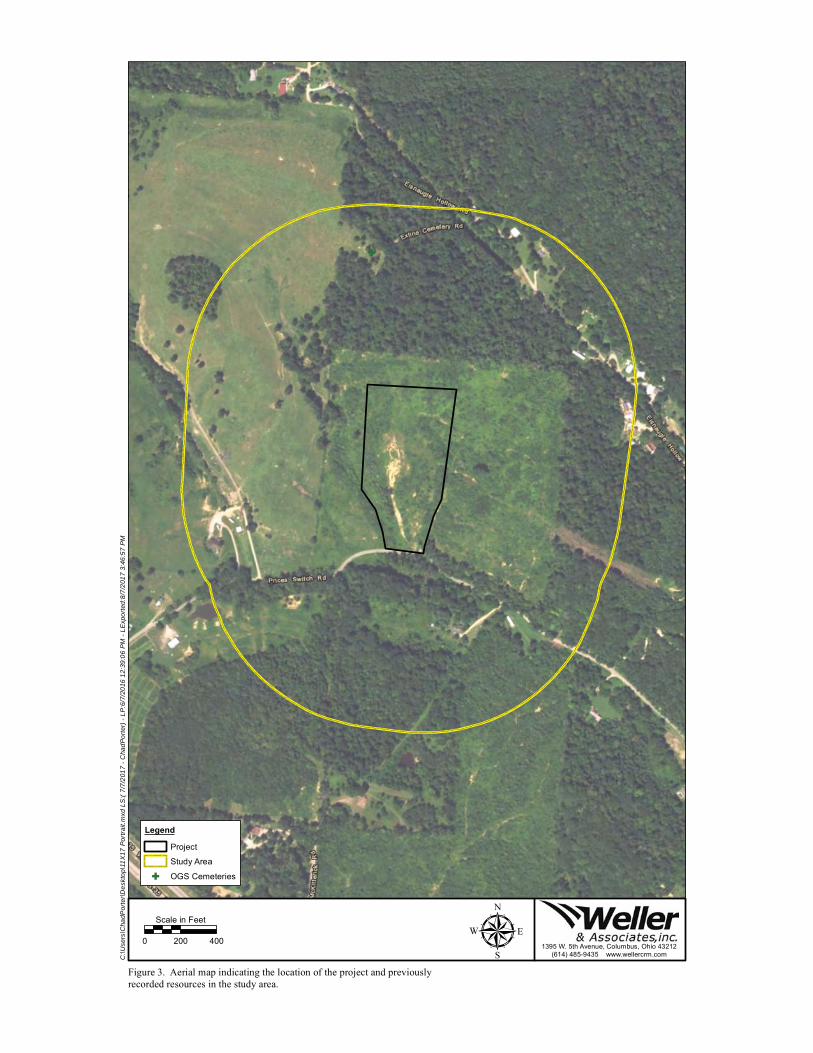
G
μ0 200 400
Scale in Feet
Legend
Project
Study Area
G OGS Cemeteries
Figure 3. Aerial map indicating the location of the project and previouslyrecorded resources in the study area.
C:\U
sers
\Cha
dPor
ter\D
eskt
op\1
1X17
Por
trait.
mxd
LS
:( 7/
7/20
17 -
Cha
dPor
ter)
- LP
:6/7
/201
6 12
:39:
06 P
M -
LExp
orte
d:8/
7/20
17 3
:46:
57 P
M
1395 W. 5th Avenue, Columbus, Ohio 43212(614) 485-9435 www.wellercrm.com

μ0 1,000 2,000
Scale in Feet
Legend
Project
Figure 4. Portion of the Archeological Atlas of Ohio (Mills' 1914) indicating the approximate location of the project.
X:\W
-227
7 H
eppn
er S
witc
h\G
IS\1
1X17
Por
trait.
mxd
LS
:( 8/
8/20
17 -
Cha
dPor
ter)
- LP
:6/7
/201
6 12
:39:
06 P
M -
LExp
orte
d:8/
9/20
17 8
:36:
15 A
M
1395 W. 5th Avenue, Columbus, Ohio 43212(614) 485-9435 www.wellercrm.com

μ0 1,000 2,000
Scale in Feet
Legend
Project
Figure 5. Portion of the USGS 1913 Jackson, Ohio 15 Minute Series (Topographic)map indicating the approximate location of the project.
X:\W
-227
7 H
eppn
er S
witc
h\G
IS\1
1X17
Por
trait.
mxd
LS
:( 8/
7/20
17 -
Cha
dPor
ter)
- LP
:6/7
/201
6 12
:39:
06 P
M -
LExp
orte
d:8/
7/20
17 3
:54:
09 P
M
1395 W. 5th Avenue, Columbus, Ohio 43212(614) 485-9435 www.wellercrm.com

S
S
S
S
S
S
S
S
S
S
")
")
Eroded
Eroded
Eroded
7
8
9
10
11
μ0 200 400
Scale in FeetProjectDisturbed (Visually Inspected)Sloped (Visually Inspected)Wet
") Disturbed Shovel ProbeSPhotos
Figure 6. Fieldwork results and photo orientation map.
X:\W
-227
7 H
eppn
er S
witc
h\G
IS\1
1X17
FW
.mxd
LS
:( 8/
11/2
017
- Ale
x) -
LP:6
/7/2
016
12:3
9:06
PM
- LE
xpor
ted:
8/11
/201
7 2:
11:4
6 P
M
1395 W. 5th Avenue, Columbus, Ohio 43212(614) 485-9435 www.wellercrm.com

Figure 7. Delineated wetland in the southern portion of the project.
Figure 8. Sloped and eroded conditions in the southern portion of the project area.

Figure 9. Disturbed conditions in the center of the project area.
Figure 10. Sloped conditions in the eastern portion of the project area.

Figure 11. Disturbed conditions in the northern portion of the project area.
Figure 12. Disturbed soils encountered in a shovel probe excavated in thecentral portion of the project area.

LETTER OF NOTIFICATION FOR HEPPNER STATION PROJECT
Appendix C Ecological Survey Report December 4, 2017
Ecological Survey Report

Prepared by: GAI Consultants, Inc. Canton Office
3720 Dressler Road Northwest Canton, Ohio 15120-2700
Prepared for: American Electric Power Service Corporation 1 Riverside Place
22nd Floor Columbus, Ohio 43215-2373
Ecological Survey Report
AEP Ohio Transmission Company Heppner Substation Project
Jackson County, Ohio
GAI Project Number: C170352.08, Task 001
September 2017

Ecological Survey Report
AEP Ohio Transmission Company Heppner Substation Project
Jackson County, Ohio
GAI Project Number: C170352.08, Task 001
September 2017
Prepared for: American Electric Power Service Corporation
1 Riverside Place 22nd Floor
Columbus, Ohio 43215-2373
Prepared by: GAI Consultants, Inc.
Canton Office 3720 Dressler Road Northwest
Canton, Ohio 15120-2700
Report Authors:
Allison R. Wheaton, WPIT Senior Project Environmental Specialist
George T. Reese, MS, CE Environmental Director

Ecological Survey Report AEP Ohio Transmission Company Heppner Substation Project
Page i
C170352.08, Task 001 / September 2017
Table of Contents 1.0 Introduction ........................................................................................................................... 1 2.0 Methods ................................................................................................................................ 1
2.1 Wetlands ..................................................................................................................... 1 2.1.1 Preliminary Data Gathering ............................................................................... 1 2.1.2 Onsite Inspection ............................................................................................. 2
2.2 Waterbodies ................................................................................................................ 3 2.2.1 Preliminary Data Gathering ............................................................................... 3 2.2.2 Onsite Inspection ............................................................................................. 3
2.3 Rare, Threatened, and Endangered Species ................................................................... 4 2.3.1 Preliminary Data Gathering ............................................................................... 4 2.3.2 Onsite Inspection ............................................................................................. 4
3.0 Results .................................................................................................................................. 4 3.1 Wetlands ..................................................................................................................... 4
3.1.1 Preliminary Data Gathering ............................................................................... 4 3.1.2 Onsite Inspection ............................................................................................. 4 3.1.3 Regulatory Discussion ...................................................................................... 4
3.2 Waterbodies ................................................................................................................ 5 3.2.1 Preliminary Data Gathering ............................................................................... 5 3.2.2 Onsite Inspection ............................................................................................. 5 3.2.3 Regulatory Discussion ...................................................................................... 5
3.3 Rare, Threatened, and Endangered Species ................................................................... 6 3.3.1 Preliminary Data Gathering ............................................................................... 6 3.3.2 Onsite Inspection ............................................................................................. 6 3.3.3 Regulatory Discussion ...................................................................................... 6
4.0 Conclusions ............................................................................................................................ 6 5.0 References ............................................................................................................................. 8
Table 1 Wetlands Identified Within the Project Study Area Table 2 Waterbodies Identified Within the Project Study Area Table 3 ODNR and USFWS RTE Species and Critical Habitat Review Results
Figure 1 Project Location Map Figure 2 Resource Location Map Figure 3 Ohio EPA Stream Eligibility Map
Appendix A Photographs Appendix B Wetland Determination Data Forms Appendix C Primary Headwater Habitat Evaluation (HHEI) Data Forms Appendix D Ohio Rapid Assessment Method for Wetlands (ORAM) Data Forms Appendix E ODNR and USFWS Correspondence © 2017 GAI CONSULTANTS

Ecological Survey Report AEP Ohio Transmission Company Heppner Substation Project
Page 1
C170352.08, Task 001 / September 2017
1.0 Introduction GAI Consultants, Inc. (GAI), on behalf of American Electric Power Ohio Transmission Company (AEP), completed an ecological survey for the Heppner Substation Project (Project) located in Jackson County, Ohio (OH). The Project involves the construction of the proposed Heppner Substation.
Ecological surveys were completed on May 16, 2017, and August 7, 2017. The study area consisted of an approximately 8.3-acre area surrounding the proposed Heppner Substation, as shown on Figure 1.
The Project study area is located within the Horse Creek - Little Salt Creek [United States Geological Survey (USGS) Hydrologic Unit Code (HUC) #050600020803] watershed.
This report details the results of the ecological surveys regarding the presence of aquatic resources within the Project area (Figure 2). The United States Army Corps of Engineers (USACE) Wetland Determination Data Forms are provided in Appendix B. Ohio Environmental Protection Agency (OEPA) Primary Headwater Habitat Evaluation (HHEI) Data Forms are provided in Appendix C and Ohio Rapid Assessment Method for Wetlands (ORAM) Data Forms are provided in Appendix D
2.0 Methods 2.1 Wetlands The 1987 USACE Corps of Engineers Wetlands Delineation Manual (Wetlands Delineation Manual) (USACE, 1987) and the 2012 Regional Supplement to the Corps of Engineers Wetland Delineation Manual: Eastern Mountains and Piedmont Region, Version 2.0 (Regional Supplement) (USACE, 2012) describe the methods used to identify and delineate wetlands that fall under the jurisdiction of the USACE. This approach recognizes the three parameters of wetland hydrology, hydrophytic vegetation, and hydric soils to identify and delineate wetland boundaries. In accordance with the Wetlands Delineation Manual and Regional Supplement, GAI completed preliminary data gathering and onsite inspections.
2.1.1 Preliminary Data Gathering
The preliminary data gathering was used to compile and review information that may be helpful in identifying wetlands and/or areas that warrant further inspection during the investigation. The preliminary data gathering included a review of the following:
USGS 7.5-minute topographic mapping for Jackson (USGS, 1978) and Wellston (USGS, 1977), OH (Figure 1);
United States Fish and Wildlife Service (USFWS), National Wetlands Inventory (NWI) mapping (USFWS, 2015) (Figure 2);
Federal Emergency Management Agency (FEMA), National Flood Hazard Layer (FEMA, 2015) (Figure 2); and
United States Department of Agriculture, Natural Resources Conservation Service (USDA-NRCS, 2015) soil mapping (Figure 2).
Topographic mapping was used to identify mapped streams and the overall shape of the landscape in the Project area to determine potential locations for wetlands, such as floodplains and depressions. NWI mapping was used to determine locations where probable wetlands are located based on infrared photography. Soil mapping was reviewed to determine the location and extent of mapped hydric soils that have a high probability of containing wetlands.
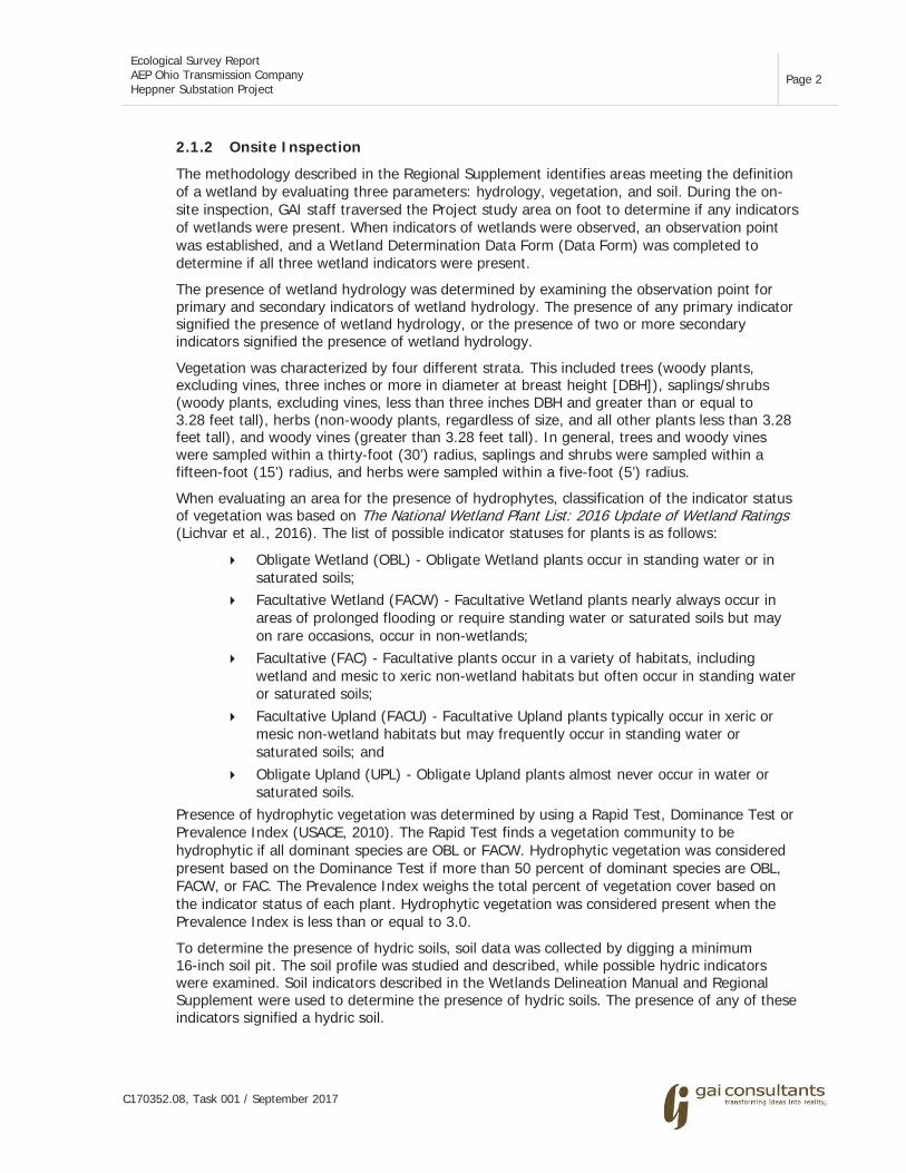
Ecological Survey Report AEP Ohio Transmission Company Heppner Substation Project
Page 2
C170352.08, Task 001 / September 2017
2.1.2 Onsite Inspection
The methodology described in the Regional Supplement identifies areas meeting the definition of a wetland by evaluating three parameters: hydrology, vegetation, and soil. During the on-site inspection, GAI staff traversed the Project study area on foot to determine if any indicators of wetlands were present. When indicators of wetlands were observed, an observation point was established, and a Wetland Determination Data Form (Data Form) was completed to determine if all three wetland indicators were present.
The presence of wetland hydrology was determined by examining the observation point for primary and secondary indicators of wetland hydrology. The presence of any primary indicator signified the presence of wetland hydrology, or the presence of two or more secondary indicators signified the presence of wetland hydrology.
Vegetation was characterized by four different strata. This included trees (woody plants, excluding vines, three inches or more in diameter at breast height [DBH]), saplings/shrubs (woody plants, excluding vines, less than three inches DBH and greater than or equal to 3.28 feet tall), herbs (non-woody plants, regardless of size, and all other plants less than 3.28 feet tall), and woody vines (greater than 3.28 feet tall). In general, trees and woody vines were sampled within a thirty-foot (30’) radius, saplings and shrubs were sampled within a fifteen-foot (15’) radius, and herbs were sampled within a five-foot (5’) radius.
When evaluating an area for the presence of hydrophytes, classification of the indicator status of vegetation was based on The National Wetland Plant List: 2016 Update of Wetland Ratings (Lichvar et al., 2016). The list of possible indicator statuses for plants is as follows:
Obligate Wetland (OBL) - Obligate Wetland plants occur in standing water or in saturated soils;
Facultative Wetland (FACW) - Facultative Wetland plants nearly always occur in areas of prolonged flooding or require standing water or saturated soils but may on rare occasions, occur in non-wetlands;
Facultative (FAC) - Facultative plants occur in a variety of habitats, including wetland and mesic to xeric non-wetland habitats but often occur in standing water or saturated soils;
Facultative Upland (FACU) - Facultative Upland plants typically occur in xeric or mesic non-wetland habitats but may frequently occur in standing water or saturated soils; and
Obligate Upland (UPL) - Obligate Upland plants almost never occur in water or saturated soils.
Presence of hydrophytic vegetation was determined by using a Rapid Test, Dominance Test or Prevalence Index (USACE, 2010). The Rapid Test finds a vegetation community to be hydrophytic if all dominant species are OBL or FACW. Hydrophytic vegetation was considered present based on the Dominance Test if more than 50 percent of dominant species are OBL, FACW, or FAC. The Prevalence Index weighs the total percent of vegetation cover based on the indicator status of each plant. Hydrophytic vegetation was considered present when the Prevalence Index is less than or equal to 3.0.
To determine the presence of hydric soils, soil data was collected by digging a minimum 16-inch soil pit. The soil profile was studied and described, while possible hydric indicators were examined. Soil indicators described in the Wetlands Delineation Manual and Regional Supplement were used to determine the presence of hydric soils. The presence of any of these indicators signified a hydric soil.

Ecological Survey Report AEP Ohio Transmission Company Heppner Substation Project
Page 3
C170352.08, Task 001 / September 2017
If all three parameters including wetland hydrology, a dominance of hydrophytic vegetation, and hydric soils were identified at a single observation point, the area was determined to be a wetland. Once a wetland was identified, the boundary was delineated.
Wetland boundaries were determined by looking for locations in which one of the three wetland indicators would transition into an upland characteristic. When the transition was identified, a Data Form was completed in the Upland Area. Wetland boundaries were then marked in the field using pink flagging labeled “WETLAND DELINEATION.” The locations of the flags were recorded using a Global Positioning System (GPS) unit. Each wetland was codified with a unique identifier indicating the feature type and number (e.g., W001).
Wetlands were then classified using the Classification of Wetlands and Deepwater Habitats of the United States (Cowardin et al., 1979) as modified for NWI Mapping Convention. This system classifies wetlands based on topographic position and vegetation type. Palustrine system wetlands found within the study area are classified as Palustrine Emergent (PEM), Palustrine Scrub-Shrub (PSS), Palustrine Forested (PFO), or Palustrine Unconsolidated Bottom (PUB) based on aerial coverage of the vegetative community across the extent of the wetland boundary (Cowardin et al., 1979).
2.2 Waterbodies As with wetlands, Section 404 of the Clean Water Act (CWA) and state regulations protect waterbodies in OH. Generally, waterbodies are defined as environmental features that have defined beds and banks, ordinary high water mark (OHWM), and contain flowing or standing water for at least a portion of the year.
2.2.1 Preliminary Data Gathering
During the preliminary data gathering, the USGS 7.5-minute topographic mapping was examined for the presence of mapped waterbodies including perennial and intermittent streams. In addition, the topographic mapping was used to identify areas likely to contain unmapped waterbodies including ephemeral streams (USGS, 1977 and 1978) (Figure 1).
The OEPA Stream Eligibility Web Map was used to determine eligibility coverage under the 401 Water Quality Certification (WQC) for the 2017 Nationwide Permits (NWPs). Furthermore, the map was used to identify any ineligible areas that may require a CWA Section 401 individual permit from the OEPA should stream impacts occur within the Project area (OEPA, 2017) (Figure 3).
2.2.2 Onsite Inspection
During the onsite inspection, GAI staff traversed the study area, concurrently with the wetland inspection, and waterbodies were identified. Waterbodies were identified based on the morphological and hydrologic characteristics of the channel and the presence of aquatic macroinvertebrates.
When a waterbody was identified, field measurements were collected. The measurements included top of bank width, top of bank depth, pool depth, water depth, OHWM width, and OHWM depth. A detailed description of substrate composition was also recorded. Waterbodies were then delineated using white flagging marked with the GAI stream code (e.g., S001). The tops-of-bank for streams wider than 10 feet were delineated and the centerline of smaller streams were delineated. The locations of the flags were recorded using a sub-meter capable hand-held GPS unit.

Ecological Survey Report AEP Ohio Transmission Company Heppner Substation Project
Page 4
C170352.08, Task 001 / September 2017
2.3 Rare, Threatened, and Endangered Species GAI conducted a literature review of potential Rare, Threatened, and Endangered (RTE) species in the vicinity of the Project study area. Potential habitat for RTE species as a result of the literature review was noted during the ecological survey.
2.3.1 Preliminary Data Gathering
A request for review of the Ohio Natural Heritage Database (ONHD) was submitted to the Ohio Department of Natural Resources (ODNR) to determine if any state-listed threatened or endangered species occur within a one-mile radius of the Project area. A request was also submitted to the USFWS Ohio Ecological Services Field Office to determine if any federally-listed threatened or endangered species occur within the vicinity of the Project area.
2.3.2 Onsite Inspection
During the onsite inspection, GAI staff traversed the study area in conjunction with the wetland and waterbody inspections to determine if suitable habitat for state- and/or federally-listed RTE species are present within the study area.
3.0 Results 3.1 Wetlands
3.1.1 Preliminary Data Gathering
Desktop review of available USFWS NWI digital data for the Project did not reveal any NWI mapped wetlands within the Project study area (USFWS, 2015).
According to the USDA-NRCS soil mapping, a total of three soil map units are located within the Project study area (Figure 2). None of the soil map units are classified as hydric and none are known to contain hydric inclusions.
3.1.2 Onsite Inspection
One PSS wetland was identified and delineated within the Project study area. In order to document site conditions, USACE Data Forms were completed for each wetland and upland reference. Information on the delineated wetlands can be found in Table 1 and photographs of the wetlands are included in Appendix A.
3.1.3 Regulatory Discussion
The USACE guidance divides waterbodies into three groups: Traditionally Navigable Waters (TNWs), non-navigable Relatively Permanent Waters (RPWs), and non-navigable Non-RPWs. TNWs are waterbodies which have been, are, or may be susceptible to use in interstate commerce, including recreational use of the waterbody. RPWs are waterbodies that flow year round, or at a minimum seasonally, by exhibiting continuous flow for at least three consecutive months, but are not TNWs (USACE, 2007). Non-RPWs are waterbodies that do not flow continuously for at least three consecutive months, are not TNWs or RPWs, but typically exhibit characteristic beds, banks, and OHWM (USACE, 2007).
The status of wetlands is determined partly based on the classification of the waterbody that the wetland is associated with, and the degree of that association. Wetlands that abut or are adjacent to TNWs are jurisdictional. Wetlands that abut RPWs are jurisdictional. Wetlands that are adjacent to RPWs and wetlands that abut or are adjacent to Non-RPWs must be subjected to the Significant Nexus Test (SNT) to determine their jurisdictional status. Generally, the USACE considers wetlands that are isolated, meaning that they are not associated with any

Ecological Survey Report AEP Ohio Transmission Company Heppner Substation Project
Page 5
C170352.08, Task 001 / September 2017
other surface water feature, as non-jurisdictional; and wetlands that abut or are adjacent to Non-RPWs as needing further examination by the USACE to determine and verify whether they exhibit a significant nexus to waters of the United States. If these wetlands exhibit a significant nexus, they are jurisdictional; if not, they are not subject to USACE jurisdiction.
Wetlands that do not exhibit an association with any surface water are categorized as “isolated” under present USACE guidance and policy. These wetlands are regulated by the OEPA Division of Surface Water, and may require an Isolated Wetland Permit.
As regulated by Ohio Administrative Code (OAC) rules 3745-1-50 through 3745-1-54, wetlands were also evaluated using the ORAM to determine the appropriate wetland category. Any wetland score that fell within a gray zone between categories was scored one of two ways. Either the wetland was assigned to the higher of the two categories or it was assessed using a non-rapid method to determine its quality (Mack, 2001). The category assigned to a particular wetland determines the requirement, if any, for additional levels of protection administered by the OEPA.
All wetlands within the study area were identified as jurisdictional. Jurisdictional status is the opinion of GAI and must be confirmed by USACE and state agencies through the Jurisdictional Determination (JD) process.
3.2 Waterbodies 3.2.1 Preliminary Data Gathering
Desktop review of the available USGS topographic mapping did not reveal any previously mapped stream segments located within the Project study area (Figure 1). Desktop review of OEPA’s Stream Eligibility Web Map revealed the Project is located within a possibly eligible area for automatic 401 WQC coverage (Figure 3).
3.2.2 Onsite Inspection
One intermittent stream segment was identified and delineated within the Project study area. Information on the delineated waterbodies and their classifications can be found in Table 2, and photographs of the identified stream are included in Appendix A.
3.2.3 Regulatory Discussion
As with wetlands, present USACE guidance and policy determines the jurisdictional status of waterbodies identified during the Project. TNWs and RPWs are jurisdictional. Non-RPWs must be subjected to the SNT by USACE to determine their jurisdictional status. If Non-RPWs exhibit a Significant Nexus, as defined in USACE guidance documents, they are jurisdictional. If not, they do not fall under the jurisdiction of the USACE.
Streams are generally defined as environmental features that have defined beds and banks, an OHWM as defined in Regulatory Guidance Letter No. 05-05 (USACE, 2005), and contain flowing or standing waters for at least a portion of the year. Streams were classified as perennial, intermittent, or ephemeral based upon presence of flow, estimated duration of flow, stream bed characteristics, and presence of aquatic biota. The USACE Jurisdictional Determination Form Instructional Guidebook (USACE, 2007) was used to determine stream classification and flow status.
As regulated by OAC Chapter 3745-1 and Section 401 WQC, streams were also assessed according to OEPA guidance using either the HHEI for watersheds less than one square mile in size, or the Qualitative Habitat Evaluation Index (QHEI) for watersheds between one and 20 square miles in size.
Ecological Survey Report AEP Ohio Transmission Company Heppner Substation Project
Page 6
C170352.08, Task 001 / September 2017
The stream segment (S001) is identified as an Unnamed Tributary (UNT) to Horse Creek. This stream segment was evaluated using the HHEI and determined to be located within a possibly eligible area for coverage under the 401 WQC for NWPs.
3.3 Rare, Threatened, and Endangered Species 3.3.1 Preliminary Data Gathering
Desktop review of ODNR, Division of Wildlife’s Ohio’s Listed Species revealed 321 Endangered, Threatened, Species of Concern, and Species of Interest located in OH (ODNR, 2016). Seventeen of the state-listed species are considered federally Endangered, and four are federally Threatened.
A review of the USFWS County Distribution of Federally-Listed Threatened, Endangered, Proposed, and Candidate Species for Ohio as well as the Information for Planning and Consultation (IPaC) website revealed two federally Endangered or Threatened species that may occur within the Project study area (USFWS, 2017). The list of species includes the following:
Indiana bat (Myotis sodalis) - Endangered; Northern long-eared bat (Myotis septentrionalis) - Threatened; and Running buffalo clover (Trifolium stoloniferum) - Endangered.
In addition to the species listed above, there are nine species of migratory birds that may occur within the Project study area.
3.3.2 Onsite Inspection
Potential habitat for RTE species was evaluated within the Project study area. In general, the habitat encountered within the study area consisted of early successional scrub-shrub habitat, maintained right-of-way, and PSS wetland.
3.3.3 Regulatory Discussion
State-listed RTE species fall under the jurisdiction of the ODNR, Division of Wildlife, while federally-listed species are covered under Section 7 of the Endangered Species Act. The Bald and Golden Eagle Protection Act and Migratory Bird Act aim to extend protection to certain bird species that fall under the jurisdiction of the USFWS. Based on the desktop review and on-site inspection, informal consultation with the ODNR and USFWS has been initiated to determine if any activities associated with the proposed Project may affect state- and/or federally-listed RTE species. The ODNR and USFWS consultation letters were submitted on May 11, 2017, and are provided in Appendix E. A response from the USFWS was received on June 2, 2017, and the ODNR response was received on August 22, 2017. Both response letters are provided in Appendix E.
4.0 Conclusions Ecological surveys were conducted within the Project study area on May 16, 2017, and August 7, 2017. One PSS wetland and one intermittent stream were identified within the Project study area. Summaries of the delineated aquatic features are provided in Tables 1 and 2, and a map depicting their location is included as Figure 2. Photographs of the wetland and stream features, as well as current site conditions, are included in Appendix A. Wetland Determination Data Forms documenting the investigation are provided in Appendix B, with HHEI and ORAM Data Forms provided in Appendix C and D, respectively.

Ecological Survey Report AEP Ohio Transmission Company Heppner Substation Project
Page 7
C170352.08, Task 001 / September 2017
The jurisdictional status of these features are considered preliminary and should be confirmed with the USACE and state agencies through the JD process.
Ecological Survey Report AEP Ohio Transmission Company Heppner Substation Project
Page 8
C170352.08, Task 001 / September 2017
5.0 References Cowardin, D. M., V. Carter, F. C. Golet, and E. T. La Roe. 1979. Classification of Wetlands and
Deepwater Habitats of the United States. United States Department of the Interior, Fish and Wildlife Service. Publication No. FWS/OBS 79/31. Washington, D.C.
Environmental Laboratory. 1987. Corps of Engineers Wetlands Delineation Manual. United States Department of the Army, United States Army Engineer Waterways Experiment Station. Technical Report Y-87-1. Vicksburg, Mississippi.
Federal Emergency Management Agency. 2015. National Flood Hazard Layer Web Map Service (WMS). Available from https://hazards.fema.gov/femaportal/wps/portal/NFHLWMSkmzdownload.
Lichvar, R. W., D.L. Banks N. C. Melvin, and W. N. Kirchner. 2016. The National Wetland Plant List: 2016 Update of Wetland Ratings. Phytoneuron 2016-30: 1-17. United States Army Corps of Engineers, Engineer Research and Development Center, Cold Regions Research and Engineering Laboratory, Hanover, New Hampshire, and BONAP, Chapel Hill, North Carolina. Available from http://rsgisias.crrel.usace.army.mil/NWPL/.
Mack, John J. 2001. Ohio Rapid Assessment Methods for Wetlands Manual for Using Version 5.0. Ohio EPA Technical Bulletin Wetland/2001-1-1. Ohio Environmental Protection Agency, Division of Surface Water, 401 Wetland Ecology Unit, Columbus, Ohio.
Ohio Administrative Code. 2011. State of Ohio: Water Quality Standards, Chapter 3745-1.
Ohio Department of Natural Resources, Division of Wildlife. Ohio’s Listed Species. https://wildlife.ohiodnr.gov/portals/wildlife/pdfs/publications/information/pub356.pdf.
Ohio Environmental Protection Agency. 2006. Methods for Assessing Habitat in Flowing Waters: Using the Qualitative Habitat Evaluation Index (QHEI). Ohio EPA Division of Surface Water, Columbus, Ohio.
Ohio Environmental Protection Agency. 2012. Field Evaluation Manual for Ohio’s Primary Headwater Habitat Streams. Version 3.0. Ohio EPA Division of Surface Water, Columbus, Ohio. 117 pp.
Ohio Environmental Protection Agency, Division of Surface Water. 2017. 401 Water Quality Certification for the Nationwide Permits Stream Eligibility Web Map (2017 Reissuance). http://oepa.maps.arcgis.com/apps/webappviewer/index.html?id=e6b46d29a38f46229c1eb47deefe49b6.
Soil Survey Staff, Natural Resources Conservation Service, United States Department of Agriculture. Soil Survey Geographic (SSURGO) Database for Jackson County, Ohio. Available online at http://websoilsurvey.sc.egov.usda.gov/App/HomePage.htm.
United States Army Corps of Engineers. 2012. Regional Supplement to the Corps of Engineers Wetland Delineation Manual: Eastern Mountains and Piedmont Region Version 2.0, ed. J. S. Wakeley, R. W. Lichvar, C. V. Noble, and J. F. Berkowitz. ERDC/EL TR-10-9. Vicksburg, Mississippi: United States Army Engineer Research and Development Center.
United States Army Corps of Engineers. 2007. Jurisdictional Determination Form Instructional Guidebook. Available from http://www.usace.army.mil/Portals/2/docs/civilworks/regulatory/ cwa_guide/jd_guidebook_051207final.pdf. Accessed March 2017.
United States Fish and Wildlife Service, Environmental Conservation Online System. Information for Planning and Consultation. https://ecos.fws.gov/ipac/.

Ecological Survey Report AEP Ohio Transmission Company Heppner Substation Project
Page 9
C170352.08, Task 001 / September 2017
United States Fish and Wildlife Service. 2015. National Wetlands Inventory for Ohio. Washington, D.C.: U.S. Fish and Wildlife Service, Division of Habitat and Resource Conservation. Available from http://www.fws.gov/wetlands/Data/Mapper.html.
United States Fish and Wildlife Service. 2017. County Distribution of Federally-Listed Endangered, Threatened, and Proposed Species. U.S. Fish and Wildlife Service, Endangered Species, Midwest Region. Available from https://www.fws.gov/midwest/endangered/lists/ohio-cty.html.
United States Geological Survey. 1977. Wellston, Ohio 7.5-Minute Topographic Quadrangle (1:24,000).
United States Geological Survey. 1978. Jackson, Ohio 7.5-Minute Topographic Quadrangle (1:24,000).

Ecological Survey Report AEP Ohio Transmission Company Heppner Substation Project
C170352.08, Task 001 / September 2017
TABLES

Ecol
ogic
al S
urve
y R
epor
t AE
P O
hio
Tran
smis
sion
Com
pany
H
eppn
er S
ubst
atio
n Pr
ojec
t
C170
352.
08, T
ask
001
/ Se
ptem
ber
2017
Tabl
e 1
W
etla
nds
Ide
nti
fied
Wit
hin
the
Pro
ject
Stu
dy A
rea
Wet
land
I.D
.1 La
titu
de2
Long
itu
de2
Pro
xim
al W
ater
body
U
SAC
E C
lass
ific
atio
n3 C
owar
din
Cla
ssif
icat
ion
4 Si
ze5
(acr
es)
OR
AM
v.
5.0
Sc
ore6
OR
AM
C
ateg
ory7
Figu
re 2
(s
heet
)
W00
1-PS
S-CA
T2
39.0
8588
0 -8
2.63
1644
U
NT
to H
orse
Cre
ek
Juris
dict
iona
l; Ab
uttin
g PS
S 0.
088
33
2 1
Not
es:
1 G
AI m
ap d
esig
natio
n.
2 N
orth
Am
eric
an D
atum
, 198
3.
3 Ju
risdi
ctio
nal s
tatu
s is
the
opi
nion
of
GAI
and
mus
t be
con
firm
ed b
y U
SACE
and
sta
te a
genc
ies
thro
ugh
the
JD p
roce
ss.
4 PS
S -
Palu
strin
e Sc
rub-
Shru
b.
5 To
tal a
crea
ge o
f w
etla
nd lo
cate
d w
ithin
the
Pro
ject
stu
dy a
rea.
6
Inte
rim s
corin
g br
eakp
oint
s fo
r w
etla
nd r
egul
ator
y ca
tego
ries
for
OR
AM v
5.0
Sco
re:
Cate
gory
1 s
core
0 -
29.
9; C
ateg
ory
1 or
2 g
ray
zone
sco
re 3
0 -
34.9
; Ca
tego
ry
mod
ified
2 s
core
35
- 44
.9;
Cate
gory
2 s
core
45
- 59
.9;
Cate
gory
2 o
r 3
scor
e 60
- 6
4.9;
Cat
egor
y 3
scor
e 65
- 1
00. O
EPA
Ecol
ogy
Uni
t D
ivis
ion
of S
urfa
ce W
ater
. ORA
M
v. 5
.0 Q
ualit
ativ
e Sc
ore
Calib
ratio
n. D
ated
Aug
ust
15, 2
000.
htt
p://
ww
w.e
pa.o
hio.
gov/
port
als/
35/4
01/o
ram
50sc
_s.p
df.
7 O
AC R
ule
3745
-1-5
4(C)
(2)
defin
es C
ateg
ory
1 w
etla
nds
as w
etla
nds
whi
ch “
…su
ppor
t m
inim
al w
ildlif
e ha
bita
t, a
nd m
inim
al h
ydro
logi
cal a
nd r
ecre
atio
n fu
nctio
ns,”
and
as
wet
land
s w
hich
hav
e “.
.hyd
rolo
gic
isol
atio
n, lo
w s
peci
es d
iver
sity
, a p
redo
min
ance
of
non-
nativ
e sp
ecie
s, n
o si
gnifi
cant
hab
itat
or w
ildlif
e us
e, a
nd li
mite
d po
tent
ial t
o ac
hiev
e be
nefic
ial w
etla
nd f
unct
ions
.”
Cate
gory
2 w
etla
nds
are
defin
ed a
s w
etla
nds
whi
ch "
...su
ppor
t m
oder
ate
wild
life
habi
tat,
or h
ydro
logi
cal o
r re
crea
tiona
l fu
nctio
ns,"
and
as
wet
land
s w
hich
are
"...
dom
inat
ed b
y na
tive
spec
ies
but
gene
rally
with
out
the
pres
ence
of,
or h
abita
t fo
r, r
are,
thr
eate
ned
or e
ndan
gere
d sp
ecie
s; a
nd
wet
land
s w
hich
are
deg
rade
d bu
t ha
ve a
rea
sona
ble
pote
ntia
l for
ree
stab
lishi
ng lo
st w
etla
nd f
unct
ions
." D
egra
ded
but
Res
tora
ble
Cate
gory
2 W
etla
nds
are
acco
rdin
g to
O
AC R
ule
3745
-1-5
4(C)
sta
tes
that
wet
land
s th
at a
re a
ssig
ned
to C
ateg
ory
2 co
nstit
ute
the
broa
d m
iddl
e ca
tego
ry t
hat
“...s
uppo
rt m
oder
ate
wild
life
habi
tat,
or
hydr
olog
ical
or
recr
eatio
nal f
unct
ions
," b
ut a
lso
incl
ude
"...w
etla
nds
whi
ch a
re d
egra
ded
but
have
a r
easo
nabl
e po
tent
ial f
or r
eest
ablis
hing
lost
wet
land
fun
ctio
ns."
OAC
R
ule
3745
-1-5
4(C)
(2)
defin
es C
ateg
ory
3 w
etla
nds
as w
etla
nds
whi
ch “
…su
ppor
t su
perio
r ha
bita
t, o
r hy
drol
ogic
al o
r re
crea
tiona
l fun
ctio
ns,”
and
as
wet
land
s w
hich
hav
e “…
high
leve
ls o
f di
vers
ity, a
hig
h pr
opor
tion
of n
ativ
e sp
ecie
s, o
r hi
gh f
unct
iona
l val
ues.
”

Ecol
ogic
al S
urve
y R
epor
t AE
P O
hio
Tran
smis
sion
Com
pany
H
eppn
er S
ubst
atio
n Pr
ojec
t
C170
352.
08, T
ask
001
/ Se
ptem
ber
2017
Tabl
e 2
W
ater
bodi
es I
dent
ifie
d W
ithi
n t
he P
roje
ct S
tudy
Are
a
Stre
am I
.D.1
Wat
erbo
dy N
ame
OEP
A W
Q
Des
ign
atio
n2 O
EPA
Str
eam
El
igib
ility
3 St
ream
Typ
e U
SAC
E C
lass
ific
atio
n4
HH
EI
Scor
e5
PH
WH
Cla
ss5
QH
EI
Scor
e6
Ban
k W
idth
7 (f
eet)
OH
WM
W
idth
(f
eet)
OH
WM
D
epth
(i
nche
s)
Stre
am
Leng
th8
(fee
t)
Lati
tude
9 Lo
ngit
ude
9 Fi
gure
2
(she
et)
S001
U
NT
to H
orse
Cre
ek
- Po
ssib
ly E
ligib
le
Inte
rmitt
ent
RPW
40
M
odifi
ed C
lass
II
- 4
2 4
392
39.0
8597
2 -8
2.63
1712
1
Not
es:
1 G
AI m
ap d
esig
natio
n.
2 As
def
ined
by
OAC
Cha
pter
374
5-1
Wat
er Q
ualit
y St
anda
rds,
Wat
er u
se d
esig
natio
ns a
nd s
tate
wid
e cr
iteria
(O
AC 3
745-
1-24
). h
ttp:
//w
ww
.epa
.ohi
o.go
v/ds
w/r
ules
/374
5_1.
aspx
. 3
As d
efin
ed b
y th
e 40
1 W
QC
cond
ition
s fo
r st
ream
elig
ibili
ty c
over
age
unde
r th
e 20
17 N
WP
prog
ram
. Str
eam
s lo
cate
d in
Pos
sibl
y El
igib
le a
reas
are
elig
ible
for
cov
erag
e if
the
pH is
<6.
5 or
str
eam
flo
w is
eph
emer
al. S
trea
ms
loca
ted
in P
ossi
bly
Elig
ible
are
as a
re a
lso
elig
ible
for
cov
erag
e if
the
HH
EI s
core
is <
50, o
r if
the
HH
EI s
core
is b
etw
een
50-6
9 an
d su
bstr
ate
com
posi
tion
is ≤
10%
coa
rse
type
s (in
clud
es c
umul
ativ
e pe
rcen
tage
of b
edro
ck, b
ould
ers,
bou
lder
sla
bs, a
nd c
obbl
e).
4 Ju
risdi
ctio
nal s
tatu
s is
the
opi
nion
of
GAI
and
mus
t be
con
firm
ed b
y U
SACE
and
sta
te a
genc
ies
thro
ugh
the
JD p
roce
ss. R
PW -
Rel
ativ
ely
Perm
anen
t W
ater
s.
5 Sc
orin
g fo
r O
EPA
Hea
dwat
er H
abita
t Ev
alua
tion
Inde
x (H
HEI
) Pr
imar
y H
eadw
ater
Hab
itats
(PH
WH
). C
lass
I =
0 -
29.
9 an
d in
clud
e “n
orm
ally
dry
cha
nnel
s w
ith li
ttle
or
no a
quat
ic li
fe p
rese
nt”;
Cla
ss I
I =
30
- 69
.9 a
nd a
re e
quiv
alen
t to
“w
arm
wat
er h
abita
t”;
Clas
s II
I =
70
– 10
0 an
d ty
pica
lly h
ave
pere
nnia
l flo
w w
ith c
ool-c
old
wat
er a
dapt
ed n
ativ
e fa
una.
6
Nar
rativ
e ra
ting
for
head
wat
er s
trea
ms
usin
g th
e O
EPA
Qua
litat
ive
Hab
itat
Eval
uatio
n In
dex
(QH
EI).
Exc
elle
nt =
≥70
; G
ood
= 5
5 -
60;
Fair
= 4
3 -
54;
Poor
= 3
0 -
42;
Very
Poo
r =
<30
. 7
Wid
th in
fee
t fr
om t
ops
of s
trea
m b
ank.
8
Tota
l str
eam
leng
th (
in f
eet)
loca
ted
with
in t
he P
roje
ct s
tudy
are
a.
9 N
orth
Am
eric
an D
atum
, 198
3.

Ecol
ogic
al S
urve
y R
epor
t AE
P O
hio
Tran
smis
sion
Com
pany
H
eppn
er S
ubst
atio
n Pr
ojec
t
C170
352.
08, T
ask
001
/ Se
ptem
ber
2017
Tabl
e 3
O
DN
R a
nd U
SFW
S R
TE S
peci
es a
nd
Cri
tica
l Hab
itat
Rev
iew
Res
ults
Com
mon
Nam
e Sc
ient
ific
Nam
e H
abit
at T
ype
List
ing
Stat
us2
Hab
itat
Typ
e P
rese
nt
Wit
hin
the
Pro
ject
Are
a?
Impa
cts
to H
abit
at/S
peci
es
Ant
icip
ated
? R
estr
icte
d C
onst
ruct
ion
Dat
es
Am
phib
ians
Mid
land
mud
sal
aman
der1
Pseu
dotr
iton
mon
tanu
s di
astic
tus
Sprin
gs, s
eeps
and
cre
eks
unde
r la
rge,
fla
t st
ones
T
Yes
No;
Per
the
OD
NR
res
pons
e, t
his
Proj
ect
is n
ot li
kely
to
impa
ct t
his
spec
ies
-
Bat
s
Indi
ana
bat1,
2 M
yotis
sod
alis
Tr
ees
>3”
dbh
E,
FE
Yes
No;
Avo
ided
with
win
ter
tree
cle
arin
g Ap
ril 1
to
Sept
embe
r 30
Nor
ther
n lo
ng-e
ared
bat
2 M
yotis
sep
tent
riona
lis
Roo
st in
cav
ities
or
in c
revi
ces
of
both
live
tre
es a
nd s
nags
; H
iber
nate
in c
aves
and
min
es
with
con
stan
t te
mpe
ratu
res,
hig
h hu
mid
ity, a
nd n
o ai
r cu
rren
ts
FT
Yes
No;
Avo
ided
with
win
ter
tree
cle
arin
g Ap
ril 1
to
Sept
embe
r 30
Fish
Ohi
o la
mpr
ey1
Icht
hyom
yzon
bde
llium
Th
e O
hio
Riv
er a
nd t
he lo
wer
po
rtio
n of
its
trib
utar
ies.
E
Yes
No;
Per
the
OD
NR
res
pons
e, t
his
Proj
ect
is n
ot li
kely
to
impa
ct t
his
spec
ies
Lake
chu
bsuc
ker1
Erim
yzon
suc
etta
Nat
ural
lake
s an
d ve
ry s
lugg
ish
stre
ams
or m
arsh
es w
ith d
ense
aq
uatic
veg
etat
ion
and
clea
r w
ater
s
T Ye
s N
o; P
er t
he O
DN
R r
espo
nse,
thi
s Pr
ojec
t is
not
like
ly t
o im
pact
thi
s sp
ecie
s -
Inse
cts
Reg
al f
ritill
ary
Spey
eria
idal
ia
Tall-
gras
s an
d m
ixed
-gra
ss
prai
ries
E N
o N
o; K
now
n ha
bita
t ty
pes
are
not
pres
ent
with
in t
he P
roje
ct a
rea
-
Mam
mal
s
Blac
k be
ar1
Ursu
s am
eric
anus
La
rge
fore
sted
are
as
E Ye
s N
o; P
er t
he O
DN
R r
espo
nse,
thi
s Pr
ojec
t is
not
like
ly t
o im
pact
thi
s sp
ecie
s -
Alle
ghen
y w
oodr
at
Neo
tom
a m
agis
ter
Roc
ky a
reas
ass
ocia
ted
with
m
ount
ain
ridge
s su
ch a
s cl
iffs,
ca
ves,
and
roc
ky f
issu
res
E N
o N
o; K
now
n ha
bita
t ty
pes
are
not
pres
ent
with
in t
he P
roje
ct a
rea
-

Ecol
ogic
al S
urve
y R
epor
t AE
P O
hio
Tran
smis
sion
Com
pany
H
eppn
er S
ubst
atio
n Pr
ojec
t
C170
352.
08, T
ask
001
/ Se
ptem
ber
2017
Com
mon
Nam
e Sc
ient
ific
Nam
e H
abit
at T
ype
List
ing
Stat
us2
Hab
itat
Typ
e P
rese
nt
Wit
hin
the
Pro
ject
Are
a?
Impa
cts
to H
abit
at/S
peci
es
Ant
icip
ated
? R
estr
icte
d C
onst
ruct
ion
Dat
es
Mam
mal
s (C
ont.
)
Bobc
at
Lynx
ruf
us
Varie
s; G
ener
ally
sol
itary
, te
rrito
rial,
and
elus
ive
T N
o N
o; I
mpa
cts
are
not
antic
ipat
ed d
ue t
o th
e Pr
ojec
t lo
catio
n -
Mus
sels
Elep
hant
-ear
El
liptio
cra
ssid
ens
cras
side
ns
Larg
e riv
ers
in m
ud, s
and,
or
fine
grav
el
E N
o N
o; K
now
n ha
bita
t ty
pes
are
not
pres
ent
with
in t
he P
roje
ct a
rea
-
Shar
p-rid
ged
pock
etbo
ok
Lam
psili
s ov
ata
Larg
e riv
ers
in c
oars
e sa
nd o
r gr
avel
E N
o N
o; K
now
n ha
bita
t ty
pes
are
not
pres
ent
with
in t
he P
roje
ct a
rea
-
Litt
le s
pect
acle
case
1 Vi
llosa
lien
osa
Smal
l to
med
ium
str
eam
s in
san
d or
gra
vel
E Ye
s N
o; P
er t
he O
DN
R r
espo
nse,
thi
s Pr
ojec
t is
not
like
ly t
o im
pact
thi
s sp
ecie
s -
Blac
k sa
ndsh
ell
Ligu
mia
rec
ta
Med
ium
to
larg
e riv
ers
in r
iffle
s or
rac
eway
s in
gra
vel o
r fir
m
sand
T
No
No;
Kno
wn
habi
tat
type
s ar
e no
t pr
esen
t w
ithin
the
Pro
ject
are
a -
Faw
nsfo
ot
Trun
cilla
don
acifo
rmis
La
rge
river
s or
the
low
er r
each
es
of m
ediu
m-s
ized
str
eam
s in
san
d or
gra
vel
T N
o N
o; K
now
n ha
bita
t ty
pes
are
not
pres
ent
with
in t
he P
roje
ct a
rea
-
Pond
horn
Un
iom
erus
tetr
alas
mus
Po
nds,
sm
all c
reek
s, a
nd t
he
head
wat
ers
of la
rger
str
eam
s in
m
ud o
r sa
nd
T N
o N
o; K
now
n ha
bita
t ty
pes
are
not
pres
ent
with
in t
he P
roje
ct a
rea
-
Plan
ts
Smal
l whi
te s
nake
root
Ag
erat
ina
arom
atic
A
varie
ty o
f w
ell-d
rain
ed o
pen
area
s on
aci
dic
soils
E
No
No;
Kno
wn
habi
tat
type
s ar
e no
t pr
esen
t w
ithin
the
Pro
ject
are
a -
Loui
sian
a se
dge
Care
x lo
uisi
anic
a Sw
amp
woo
ds a
nd s
hade
d al
luvi
al s
ituat
ions
E
No
No;
Kno
wn
habi
tat
type
s ar
e no
t pr
esen
t w
ithin
the
Pro
ject
are
a -
Will
deno
w’s
cro
ton
Crot
on w
illde
now
ii Ba
rren
sto
ny o
r sa
ndy
clea
rings
E
No
No;
Kno
wn
habi
tat
type
s ar
e no
t pr
esen
t w
ithin
the
Pro
ject
are
a -
Sess
ile d
odde
r Cu
scut
a co
mpa
cta
Low
woo
ds a
nd t
hick
ets
E N
o N
o; K
now
n ha
bita
t ty
pes
are
not
pres
ent
with
in t
he P
roje
ct a
rea
-

Ecol
ogic
al S
urve
y R
epor
t AE
P O
hio
Tran
smis
sion
Com
pany
H
eppn
er S
ubst
atio
n Pr
ojec
t
C170
352.
08, T
ask
001
/ Se
ptem
ber
2017
Com
mon
Nam
e Sc
ient
ific
Nam
e H
abit
at T
ype
List
ing
Stat
us2
Hab
itat
Typ
e P
rese
nt
Wit
hin
the
Pro
ject
Are
a?
Impa
cts
to H
abit
at/S
peci
es
Ant
icip
ated
? R
estr
icte
d C
onst
ruct
ion
Dat
es
Plan
ts (
Cont
.)
Man
y-flo
wer
ed u
mbr
ella
se
dge
Cype
rus
lanc
astr
iens
is
A va
riety
of
open
, dry
situ
atio
ns,
usua
lly in
san
dy s
oils
; Fi
elds
, ba
rren
s, c
lear
ings
, and
ope
n w
oods
E N
o N
o; K
now
n ha
bita
t ty
pes
are
not
pres
ent
with
in t
he P
roje
ct a
rea
-
Rou
gh u
mbr
ella
-sed
ge
Cype
rus
retr
ofra
ctus
A
varie
ty o
f op
en, d
ry s
ituat
ions
, us
ually
in s
andy
soi
l; Fi
elds
, ope
n w
oods
, cle
arin
gs, a
nd b
arre
ns
E N
o N
o; K
now
n ha
bita
t ty
pes
are
not
pres
ent
with
in t
he P
roje
ct a
rea
-
Velv
et p
anic
gra
ss
Dic
hant
heliu
m s
copa
rium
Se
epag
e m
eado
ws
E N
o N
o; K
now
n ha
bita
t ty
pes
are
not
pres
ent
with
in t
he P
roje
ct a
rea
-
Enge
lman
n’s
spik
e ru
sh
Eleo
char
is e
ngel
man
nii
Mud
flats
alo
ng m
argi
ns o
f po
nds
and
lake
s E
No
No;
Kno
wn
habi
tat
type
s ar
e no
t pr
esen
t w
ithin
the
Pro
ject
are
a -
Wol
f’s s
pike
-rus
h El
eoch
aris
wol
fii
Moi
st, o
pen
area
s; P
ond
mar
gins
; Fi
elds
E
No
No;
Kno
wn
habi
tat
type
s ar
e no
t pr
esen
t w
ithin
the
Pro
ject
are
a -
Hys
sop
thor
ough
wor
t Eu
pato
rium
hys
sopi
foliu
m
A va
riety
of
wel
l-dra
ined
, ope
n ar
eas
on a
cidi
c so
ils
E N
o N
o; K
now
n ha
bita
t ty
pes
are
not
pres
ent
with
in t
he P
roje
ct a
rea
-
Sam
pson
’s s
nake
root
G
entia
na v
illos
a M
esic
woo
dlan
ds, p
inel
ands
, dry
ra
vine
s, a
nd r
oads
ides
E
No
No;
Kno
wn
habi
tat
type
s ar
e no
t pr
esen
t w
ithin
the
Pro
ject
are
a -
Copp
ery
St. J
ohn’
s-w
ort
Hyp
eric
um d
entic
ulat
um
Usu
ally
wet
, sha
ded
to o
pen
situ
atio
ns;
Low
woo
ds, b
ogs,
and
m
arsh
es
E N
o N
o; K
now
n ha
bita
t ty
pes
are
not
pres
ent
with
in t
he P
roje
ct a
rea
-
Appa
lach
ian
quill
wor
t Is
oete
s en
gelm
anni
i O
pen
sun
in s
hallo
w b
odie
s of
w
ater
; Po
nd m
argi
ns a
nd d
itche
s E
No
No;
Kno
wn
habi
tat
type
s ar
e no
t pr
esen
t w
ithin
the
Pro
ject
are
a -
Woo
dlan
d ru
sh
Junc
us s
ubca
udat
us
Mar
shes
, edg
es o
f st
ream
s, a
nd
peat
y ac
idic
and
bas
ic w
etla
nds
incl
udin
g fe
ns;
Wid
e va
riety
of
wet
hab
itats
E N
o N
o; K
now
n ha
bita
t ty
pes
are
not
pres
ent
with
in t
he P
roje
ct a
rea
-
One
-con
ed c
lub-
mos
s Ly
copo
dium
lago
pus
Ope
ning
s in
woo
dlan
ds a
nd f
ield
s E
No
No;
Kno
wn
habi
tat
type
s ar
e no
t pr
esen
t w
ithin
the
Pro
ject
are
a -
Bigl
eaf
mag
nolia
M
agno
lia m
acro
phyl
la
Mes
ic w
oode
d ra
vine
s an
d ne
ar
the
tops
of
thes
e ra
vine
s in
oak
w
oods
E
No
No;
Kno
wn
habi
tat
type
s ar
e no
t pr
esen
t w
ithin
the
Pro
ject
are
a -

Ecol
ogic
al S
urve
y R
epor
t AE
P O
hio
Tran
smis
sion
Com
pany
H
eppn
er S
ubst
atio
n Pr
ojec
t
C170
352.
08, T
ask
001
/ Se
ptem
ber
2017
Com
mon
Nam
e Sc
ient
ific
Nam
e H
abit
at T
ype
List
ing
Stat
us2
Hab
itat
Typ
e P
rese
nt
Wit
hin
the
Pro
ject
Are
a?
Impa
cts
to H
abit
at/S
peci
es
Ant
icip
ated
? R
estr
icte
d C
onst
ruct
ion
Dat
es
Plan
ts (
Cont
.)
Curt
iss’
milk
wor
t Po
lyga
la c
urtis
sii
Ope
n to
sem
i-ope
n si
tuat
ions
in
dry
to m
oist
, roc
ky t
o sa
ndy
soil;
W
ood
bord
ers,
old
fie
lds,
and
th
icke
ts
E N
o N
o; K
now
n ha
bita
t ty
pes
are
not
pres
ent
with
in t
he P
roje
ct a
rea
-
Spot
ted
pond
wee
d Po
tam
oget
on p
ulch
er
Peat
y or
mud
dy, a
cid
wat
ers
or
shor
es
E N
o N
o; K
now
n ha
bita
t ty
pes
are
not
pres
ent
with
in t
he P
roje
ct a
rea
-
Flam
e az
alea
Rh
odod
endr
on
cale
ndul
aceu
m
Ope
n w
oods
and
cle
ared
are
as
on w
ell-d
rain
ed, a
cidi
c so
ils
E N
o N
o; K
now
n ha
bita
t ty
pes
are
not
pres
ent
with
in t
he P
roje
ct a
rea
-
Nar
row
-leav
ed b
luec
urls
Tr
icho
stem
a di
chot
omum
var
. lin
eare
D
ry u
plan
d or
san
dy w
oods
; O
ld
field
s E
No
No;
Kno
wn
habi
tat
type
s ar
e no
t pr
esen
t w
ithin
the
Pro
ject
are
a -
Run
ning
buf
falo
clo
ver
Trifo
lium
sto
loni
feru
m
Mes
ic h
abita
ts w
ith p
artia
l su
nlig
ht in
clud
ing
woo
dlan
ds a
nd
mow
ed la
wns
E,
FE
No
No;
Kno
wn
habi
tat
type
s ar
e no
t pr
esen
t w
ithin
the
Pro
ject
are
a -
Prim
rose
-leav
ed v
iole
t Vi
ola
prim
ulifo
lia
Moi
st, o
pen
situ
atio
ns, u
sual
ly in
sa
ndy
soil;
Mea
dow
s, e
dges
of
pond
s, s
trea
ms,
mar
shes
, and
sw
amps
E N
o N
o; K
now
n ha
bita
t ty
pes
are
not
pres
ent
with
in t
he P
roje
ct a
rea
-
Blue
hear
ts
Buch
nera
am
eric
ana
Full
sun
in w
ell-d
rain
ed, o
ften
ro
cky,
ope
ning
s an
d w
oodl
ands
; pr
airie
s, p
astu
res,
roa
dban
ks;
at
times
on
seve
rely
ero
ded
slop
es
T N
o N
o; K
now
n ha
bita
t ty
pes
are
not
pres
ent
with
in t
he P
roje
ct a
rea
-
Bart
ley’
s R
eed
Gra
ss
Cala
mag
rost
is p
orte
ri ss
p.
insp
erat
a
Dry
upl
and
area
s in
sun
or
part
ial
shad
e; J
acks
on C
ount
y po
pula
tion
is u
nder
a
pow
erlin
e
T Ye
s N
o; K
now
n ha
bita
t ty
pes
are
not
pres
ent
with
in t
he P
roje
ct a
rea
-
Bush
’s s
edge
Ca
rex
bush
ii M
oist
pra
iries
, fie
lds,
and
m
eado
ws
in f
ull s
un
T N
o N
o; K
now
n ha
bita
t ty
pes
are
not
pres
ent
with
in t
he P
roje
ct a
rea
-
Flat
tene
d se
dge
Care
x co
mpa
nata
D
ry, o
pen
woo
ds w
ith n
eutr
al t
o ac
idic
soi
ls
T N
o N
o; K
now
n ha
bita
t ty
pes
are
not
pres
ent
with
in t
he P
roje
ct a
rea
-
Shor
t-fr
inge
d se
dge
Care
x cr
inita
var
. bre
vicr
inis
Sw
amp
woo
ds, s
eeps
in w
oods
, an
d al
ong
stre
ams
T N
o N
o; K
now
n ha
bita
t ty
pes
are
not
pres
ent
with
in t
he P
roje
ct a
rea
-

Ecol
ogic
al S
urve
y R
epor
t AE
P O
hio
Tran
smis
sion
Com
pany
H
eppn
er S
ubst
atio
n Pr
ojec
t
C170
352.
08, T
ask
001
/ Se
ptem
ber
2017
Com
mon
Nam
e Sc
ient
ific
Nam
e H
abit
at T
ype
List
ing
Stat
us2
Hab
itat
Typ
e P
rese
nt
Wit
hin
the
Pro
ject
Are
a?
Impa
cts
to H
abit
at/S
peci
es
Ant
icip
ated
? R
estr
icte
d C
onst
ruct
ion
Dat
es
Plan
ts (
Cont
.)
Rez
nice
k’s
sedg
e Ca
rex
rezn
icek
ii D
ry w
oods
on
sand
y so
ils
T N
o N
o; K
now
n ha
bita
t ty
pes
are
not
pres
ent
with
in t
he P
roje
ct a
rea
-
Lind
heim
er’s
pan
ic g
rass
D
icha
nthe
lium
lind
heim
eri
Ope
n, m
oist
, gra
velly
, oft
en
calc
areo
us s
hore
s T
No
No;
Kno
wn
habi
tat
type
s ar
e no
t pr
esen
t w
ithin
the
Pro
ject
are
a -
Slen
der
spik
e-ru
sh
Eleo
char
is te
nuis
Moi
st s
oils
in x
eric
lim
esto
ne
prai
ries;
Wet
mea
dow
s, s
hore
s of
po
nds,
ditc
hes,
and
dis
turb
ed,
moi
st h
abita
ts
T N
o N
o; K
now
n ha
bita
t ty
pes
are
not
pres
ent
with
in t
he P
roje
ct a
rea
-
Whi
te t
horo
ughw
ort
Eupa
toriu
m a
lbum
A
varie
ty o
f w
ell-d
rain
ed, o
pen
area
s on
aci
dic
soils
T
No
No;
Kno
wn
habi
tat
type
s ar
e no
t pr
esen
t w
ithin
the
Pro
ject
are
a -
Rou
nd-f
ruite
d he
dge-
hyss
op
Gra
tiola
virg
inia
na
Wet
pla
ces:
str
eam
mar
gins
, po
ols,
ditc
hes,
sw
amps
; ge
nera
lly
in s
hade
or
sem
i sha
de
T N
o N
o; K
now
n ha
bita
t ty
pes
are
not
pres
ent
with
in t
he P
roje
ct a
rea
Ashy
sun
flow
er
Hel
iant
hus
mol
lis
A va
riety
of
wel
l-dra
ined
, sun
ny
open
ings
; D
ry p
rairi
es, r
ailro
ad
emba
nkm
ents
, roa
dsid
es, w
ood
bord
ers,
and
cle
arin
gs;
Usu
ally
in
neut
ral s
ubst
rate
s
T N
o N
o; K
now
n ha
bita
t ty
pes
are
not
pres
ent
with
in t
he P
roje
ct a
rea
-
Inla
nd r
ush
Junc
us in
terio
r
Moi
st t
o dr
y, o
pen
to s
emi-o
pen
situ
atio
ns;
Oft
en in
san
dy s
oil;
Roa
dsid
es, p
rairi
es, m
eado
ws,
fa
llow
fie
lds,
cle
arin
gs, a
nd
upla
nd w
oods
T N
o N
o; K
now
n ha
bita
t ty
pes
are
not
pres
ent
with
in t
he P
roje
ct a
rea
-
Pota
to-d
ande
lion
Krig
ia d
ande
lion
Ope
n oa
k w
oods
and
pra
iries
, us
ually
in m
oist
san
dy s
oils
T
No
No;
Kno
wn
habi
tat
type
s ar
e no
t pr
esen
t w
ithin
the
Pro
ject
are
a -
Thym
e-le
aved
pin
wee
d Le
chea
min
or
Usu
ally
in f
ull s
un in
dry
, san
dy
woo
ds, c
lear
ings
, and
roa
dsid
e ba
nks
T N
o N
o; K
now
n ha
bita
t ty
pes
are
not
pres
ent
with
in t
he P
roje
ct a
rea
-
Dow
ny w
hite
bea
rd-t
ongu
e Pe
nste
mon
pal
lidus
Fi
elds
, roa
dsid
es, a
nd o
pen
woo
ds
T N
o N
o; K
now
n ha
bita
t ty
pes
are
not
pres
ent
with
in t
he P
roje
ct a
rea
-

Ecol
ogic
al S
urve
y R
epor
t AE
P O
hio
Tran
smis
sion
Com
pany
H
eppn
er S
ubst
atio
n Pr
ojec
t
C170
352.
08, T
ask
001
/ Se
ptem
ber
2017
Com
mon
Nam
e Sc
ient
ific
Nam
e H
abit
at T
ype
List
ing
Stat
us2
Hab
itat
Typ
e P
rese
nt
Wit
hin
the
Pro
ject
Are
a?
Impa
cts
to H
abit
at/S
peci
es
Ant
icip
ated
? R
estr
icte
d C
onst
ruct
ion
Dat
es
Plan
ts (
Cont
.)
Caro
lina
leaf
-flo
wer
Ph
ylla
nthu
s ca
rolin
iens
is
A va
riety
of
moi
st, o
pen
to s
emi-
open
situ
atio
ns, u
sual
ly in
san
dy
soil;
Low
woo
ds, m
eado
ws,
fie
lds,
and
gra
velly
ban
ks
T N
o N
o; K
now
n ha
bita
t ty
pes
are
not
pres
ent
with
in t
he P
roje
ct a
rea
-
Pink
milk
wor
t Po
lyga
la in
carn
ata
Ope
n to
sem
i-ope
n si
tuat
ions
in
dry,
oft
en s
andy
soi
l; O
pen
upla
nd w
oods
, woo
d bo
rder
s,
prai
ries,
and
old
fie
lds
T N
o N
o; K
now
n ha
bita
t ty
pes
are
not
pres
ent
with
in t
he P
roje
ct a
rea
-
Tenn
esse
e po
ndw
eed
Pota
mog
eton
tenn
esse
ensi
s St
ill o
r flo
win
g w
ater
T
No
No;
Kno
wn
habi
tat
type
s ar
e no
t pr
esen
t w
ithin
the
Pro
ject
are
a -
Span
ish
oak
Que
rcus
falc
ata
Usu
ally
in d
ry u
plan
d w
oods
, les
s fr
eque
ntly
in a
lluvi
al w
oods
T
No
No;
Kno
wn
habi
tat
type
s ar
e no
t pr
esen
t w
ithin
the
Pro
ject
are
a -
Chal
ky r
amal
ina
Ram
alin
a po
llina
ria
Roc
k an
d ba
rk in
she
ltere
d ar
eas;
R
ecen
t O
hio
colle
ctio
ns h
ave
all
been
fro
m s
ands
tone
, eith
er c
liff
face
or
boul
ders
bel
ow a
clif
f;
Pref
ers
light
sha
de
T N
o N
o; K
now
n ha
bita
t ty
pes
are
not
pres
ent
with
in t
he P
roje
ct a
rea
-
Low
spe
arw
ort
Ranu
ncul
us p
usill
us
Low
wet
gro
und,
sw
amps
, and
sh
allo
w p
ools
T
No
No;
Kno
wn
habi
tat
type
s ar
e no
t pr
esen
t w
ithin
the
Pro
ject
are
a -
Gre
at r
hodo
dend
ron
Rhod
oden
dron
max
imum
M
oist
, coo
l, ac
idic
, wel
l-dra
ined
so
ils;
Part
ial s
hade
T
No
No;
Kno
wn
habi
tat
type
s ar
e no
t pr
esen
t w
ithin
the
Pro
ject
are
a -
Nar
row
-leav
ed a
ster
Se
ricoc
arpu
s lin
ifoliu
s D
ry, o
pen
to s
emi-o
pen
situ
atio
ns;
Upl
and
woo
ds,
thic
kets
, and
cle
arin
gs
T N
o N
o; K
now
n ha
bita
t ty
pes
are
not
pres
ent
with
in t
he P
roje
ct a
rea
-
Swee
t go
lden
rod
Solid
ago
odor
a D
ry w
oods
and
roa
dsid
es
T N
o N
o; K
now
n ha
bita
t ty
pes
are
not
pres
ent
with
in t
he P
roje
ct a
rea
-
Prai
rie w
edge
gra
ss
Sphe
noph
olis
obt
usat
a va
r. ob
tusa
ta
Very
gen
eral
ized
; M
oist
to
dry
soil
of o
pen
woo
ds, p
rairi
es, o
ld
field
s, a
nd f
en m
eado
ws
T N
o N
o; K
now
n ha
bita
t ty
pes
are
not
pres
ent
with
in t
he P
roje
ct a
rea
-
Larg
e m
arsh
St.
Joh
n’s-
wor
t Tr
iade
num
tubu
losu
m
Swam
p w
oods
, but
tonb
ush
swam
ps, t
hick
ets,
and
st
ream
bank
s T
No
No;
Kno
wn
habi
tat
type
s ar
e no
t pr
esen
t w
ithin
the
Pro
ject
are
a -

Ecol
ogic
al S
urve
y R
epor
t AE
P O
hio
Tran
smis
sion
Com
pany
H
eppn
er S
ubst
atio
n Pr
ojec
t
C170
352.
08, T
ask
001
/ Se
ptem
ber
2017
Com
mon
Nam
e Sc
ient
ific
Nam
e H
abit
at T
ype
List
ing
Stat
us2
Hab
itat
Typ
e P
rese
nt
Wit
hin
the
Pro
ject
Are
a?
Impa
cts
to H
abit
at/S
peci
es
Ant
icip
ated
? R
estr
icte
d C
onst
ruct
ion
Dat
es
Plan
ts (
Cont
.)
Wal
ter’s
St.
Joh
n’s-
wor
t Tr
iade
num
wal
teri
Swam
p w
oods
, but
tonb
ush
swam
ps, t
hick
ets,
and
st
ream
bank
s T
No
No;
Kno
wn
habi
tat
type
s ar
e no
t pr
esen
t w
ithin
the
Pro
ject
are
a -
Rep
tile
s
Tim
ber
ratt
lesn
ake1
Crot
alus
hor
ridus
W
oode
d ar
eas
E, S
C Ye
s N
o; P
er t
he O
DN
R r
espo
nse,
thi
s Pr
ojec
t is
not
like
ly t
o im
pact
thi
s sp
ecie
s -
Kirt
land
’s s
nake
1 Cl
onop
his
kirt
land
ii W
et m
eado
ws
or f
ield
s T
Yes
No;
Per
the
OD
NR
res
pons
e, t
his
Proj
ect
is n
ot li
kely
to
impa
ct t
his
spec
ies
-
Not
es:
1 O
DN
R, D
ivis
ion
of W
ildlif
e (D
OW
) co
mm
ents
incl
uded
in t
he O
DN
R r
espo
nse,
dat
ed A
ugus
t 22
, 201
7.
2 Fe
dera
lly li
sted
spe
cies
, mig
rato
ry b
ird, o
r sp
ecie
s of
con
cern
com
men
ts in
clud
ed in
the
USF
WS
resp
onse
, dat
ed J
une
2, 2
017.
3
E =
sta
te e
ndan
gere
d; T
= s
tate
thr
eate
ned;
P =
sta
te p
oten
tially
thr
eate
ned;
SC
= s
tate
spe
cies
of
conc
ern;
FE
= f
eder
al e
ndan
gere
d; F
T =
fed
eral
thr
eate
ned;
FS
C =
fed
eral
spe
cies
of
conc
ern;
FC
= f
eder
al c
andi
date
.

Ecological Survey Report AEP Ohio Transmission Company Heppner Substation Project
C170352.08, Task 001 / September 2017
FIGURES

39.0
8713
5 -8
2.63
1197
CO
AL
TOW
NSH
IP
LIB
ERTY
TOW
NSH
IP
LIC
KTO
WN
SHIP
JAC
KSO
NC
OU
NTY
PR
OJE
CT
LOC
ATIO
N
02,
000
4,00
01,
000
Feet
DR
AWN
BY:
AK
WC
HE
CK
ED
: MD
OD
ATE
: 9/2
5/20
17AP
PRO
VED
:AR
W
HE
PPN
ER
SU
BS
TATI
ON
PR
OJE
CT
AME
RIC
AN
ELE
CTR
IC P
OW
ER
FIG
UR
E 1
PRO
JEC
T LO
CAT
ION
MA
PLE
GEN
D
STU
DY
AR
EA
CO
UN
TY B
OU
ND
ARY
TOW
NSH
IP B
OU
ND
AR
Y
p
Z:\E
nerg
y\20
17\C
1703
52.0
0 - A
EP
Ohi
o P
roje
cts\
GIS
\MX
D\H
eppn
er_S
ub\W
DS
IR\P
roje
ct_L
ocat
ion_
2017
_09_
20.m
xd
RE
FER
EN
CE
: US
GS
7.5
' TO
PO
GR
AP
HIC
Q
UA
DR
AN
GLE
S: J
AC
KS
ON
(197
8) A
ND
WE
LLS
TON
(1
977)
, OH
IO, O
BTA
INE
D T
HR
OU
GH
ES
RI U
SA
TOP
O M
AP
S, N
ATIO
NA
L G
EO
GR
AP
HIC
TO
PO
AN
D
US
GS
, AC
CE
SS
ED
09/
2017
.
JAC
KS
ON
CO
UN
TY, O
HIO

S001
(IN
TER
MIT
TEN
T)
W00
1-PS
S-C
AT2
JAC
KSO
NC
OU
NTY
LIC
KTO
WN
SHIP
CO
AL
TOW
NSH
IP
RrW
1C2
CkC
Om
u1C
1
ChD
WhD
Or
ShLZ
E1Sh
LZE1
Rm
E
Px
WhC
Om
u1C
1
ShLZ
E1
Om
u1C
1
ErD
ShLZ
E1
ErD
WhD
WhD
WhD
ShLZ
E1
Om
u1C
1
PR
OJE
CT
LOC
ATIO
N
020
040
010
0Fe
etD
RAW
N B
Y: A
KW
CH
EC
KE
D: M
DO
DAT
E: 9
/25/
2017
AP
PR
OV
ED
: AR
W
HE
PPN
ER
SU
BS
TATI
ON
PR
OJE
CT
AME
RIC
AN
ELE
CTR
IC P
OW
ER
FIG
UR
E 2
RES
OU
RC
E LO
CAT
ION
MAP
LEG
END
!(C
ULV
ER
T
#U
PLA
ND
DAT
A P
OIN
T
#
WE
TLA
ND
DAT
A P
OIN
T
STR
EA
M
PS
S W
ETL
AN
D
STU
DY
AR
EA
SOIL
TY
PE
BO
UN
DA
RY
OD
NR
LA
ND
NW
I WE
TLA
ND
100-
YEAR
FLO
OD
PLA
IN
TOW
NS
HIP
B
OU
ND
AR
Y
CO
UN
TY
BO
UN
DA
RY
p
Z:\E
nerg
y\20
17\C
1703
52.0
0 - A
EP
Ohi
o P
roje
cts\
GIS
\MX
D\H
eppn
er_S
ub\W
DS
IR\R
esou
rce_
Loca
tion_
Map
_201
7_09
_20.
mxd
RE
FER
EN
CE
S: E
SR
I WO
RLD
IMA
GE
RY,
MIC
RO
SO
FT,
UC
- G
, 201
1, A
CC
ES
SE
D 0
9/20
17. W
OR
LD
TRA
NS
PO
RTA
TIO
N, E
SR
I, D
ELO
RM
E, H
ER
E, M
AP
MY
IND
IA,
TOM
TOM
, © O
PE
NS
TRE
ETM
AP
CO
NTR
IBU
TOR
S, A
ND
TH
E
GIS
US
ER
CO
MM
UN
ITY,
OB
TAIN
ED
TH
RO
UG
H E
SR
I A
RC
GIS
ON
LIN
E, A
CC
ES
SE
D 0
9/20
17. N
ATIO
NA
L W
ETL
AN
D
INV
EN
TOR
Y (N
WI)
WE
TLA
ND
S, U
SFW
S, 2
017.
NAT
ION
AL
FLO
OD
HA
ZAR
D L
AYE
R, F
ED
ER
AL
EM
ER
GE
NC
Y
MA
NA
GE
ME
NT
AG
EN
CY
(FE
MA
), O
HIO
, 201
5. S
OIL
S
UR
VE
Y G
EO
GR
AP
HIC
(SS
UR
GO
) DAT
AB
AS
E F
OR
JA
CK
SO
NC
OU
NTY
, OH
IO, U
SD
A/N
RC
S, 2
015.
OD
NR
(OH
IO
DE
PAR
TME
NT
OF
NAT
UR
AL
RE
SO
UR
CE
S) L
AN
D, 2
014.
JAC
KS
ON
CO
UN
TY, O
HIO

S001
(INTE
RM
ITTE
NT)
HorseCreek(WWH)
PR
OJE
CT
LOC
ATIO
N
060
01,
200
300
Feet
DR
AWN
BY:
AK
WC
HE
CK
ED
: MD
OD
ATE
: 9/2
5/20
17A
PP
RO
VE
D: A
RW
HE
PPN
ER
SU
BS
TATI
ON
PR
OJE
CT
AME
RIC
AN
ELE
CTR
IC P
OW
ER
FIG
UR
E 3
STR
EAM
ELI
GIB
ILIT
Y M
AP
LEG
EN
D
NH
D S
TRE
AM
OH
WQ
S S
TRE
AM
STU
DY
AR
EA
OH
IO E
PA S
TREA
M E
LIG
IBIL
ITY
INE
LIG
IBLE
PO
SS
IBLY
ELI
GIB
LE
ELI
GIB
LE
p
Z:\E
nerg
y\20
17\C
1703
52.0
0 - A
EP
Ohi
o P
roje
cts\
GIS
\MX
D\H
eppn
er_S
ub\W
DS
IR\S
tream
_Elig
ibili
ty_M
ap_2
017_
09_2
0.m
xd
RE
FER
EN
CE
S: E
SR
I WO
RLD
IMA
GE
RY,
NA
IP, 2
015,
A
CC
ES
SE
D 0
9/20
17. W
OR
LD T
RA
NS
PO
RTA
TIO
N,
ES
RI,
DE
LOR
ME
, HE
RE
, MA
PM
YIN
DIA
, TO
MTO
M,
© O
PE
NS
TRE
ETM
AP
CO
NTR
IBU
TOR
S, A
ND
TH
E
GIS
US
ER
CO
MM
UN
ITY,
OB
TAIN
ED
TH
RO
UG
H
ES
RI A
RC
GIS
ON
LIN
E, A
CC
ES
SE
D 0
9/20
17.
STR
EAM
ELI
GIB
ILIT
Y, O
HIO
EN
VIR
ON
ME
NTA
L P
RO
TEC
TIO
N A
GE
NC
Y (O
EPA
), 20
17. N
HD
S
TRE
AM
S, N
ATIO
NA
L H
YD
RO
GR
AP
HY
DAT
AS
ET
(NH
D),
US
GS
, 201
5. W
QS
STR
EA
MS
, OH
IO W
ATE
R
QU
ALI
TY S
TAN
DA
RD
S, 2
010.
JAC
KS
ON
CO
UN
TY, O
HIO

Ecological Survey Report AEP Ohio Transmission Company Heppner Substation Project
C170352.08, Task 001 / September 2017
APPENDIX A Photographs

Ecological Survey Report AEP Ohio Transmission Company Heppner Substation Project
C170352.08, Task 001 / September 2017
Photograph 1. Wetland W001-PSS-CAT2, Facing North
Photograph 2. Wetland W001-PSS-CAT2, Facing West

Ecological Survey Report AEP Ohio Transmission Company Heppner Substation Project
C170352.08, Task 001 / September 2017
Photograph 3. Stream S001, Upstream, Facing North
Photograph 4. Stream S001, Downstream, Facing South

Ecological Survey Report AEP Ohio Transmission Company Heppner Substation Project
C170352.08, Task 001 / September 2017
Photograph 5. Representative upland habitat, Facing North
Photograph 6. Representative upland habitat, Facing South

Ecological Survey Report AEP Ohio Transmission Company Heppner Substation Project
C170352.08, Task 001 / September 2017
Photograph 7. Representative upland habitat, Facing East
Photograph 8. Representative upland habitat, Facing West

Ecological Survey Report AEP Ohio Transmission Company Heppner Substation Project
C170352.08, Task 001 / September 2017
APPENDIX B Wetland Determination Data Forms


Ecological Survey Report AEP Ohio Transmission Company Heppner Substation Project
C170352.08, Task 001 / September 2017
APPENDIX C Primary Headwater Habitat
Evaluation (HHEI) Data Forms


Horse Creek

Ecological Survey Report AEP Ohio Transmission Company Heppner Substation Project
C170352.08, Task 001 / September 2017
APPENDIX D Ohio Rapid Assessment Method
for Wetlands (ORAM) Data Forms


Ecological Survey Report AEP Ohio Transmission Company Heppner Substation Project
C170352.08, Task 001 / September 2017
APPENDIX E ODNR and USFWS Correspondence

Office of Real EstatePaul R. Baldridge, Chief
2045 Morse Road – Bldg. E-2Columbus, OH 43229
Phone: (614) 265-6649Fax: (614) 267-4764
August 22, 2017
Allison WheatonGAI Consultants3720 Dressler Road NWCanton, Ohio 44718
Re: 17-395; AEP Heppner Substation Project
Project: The proposed project involves the construction of the Heppner Substation.
Location: The proposed project is located in Coal Township, Jackson County, Ohio.
The Ohio Department of Natural Resources (ODNR) has completed a review of the above referenced project. These comments were generated by an inter-disciplinary review within the Department. These comments have been prepared under the authority of the Fish and Wildlife Coordination Act (48 Stat. 401, as amended; 16 U.S.C. 661 et seq.), the National Environmental Policy Act, the Coastal Zone Management Act, Ohio Revised Code and other applicable laws and regulations. These comments are also based on ODNR’s experience as the state natural resource management agency and do not supersede or replace the regulatory authority of any local, state or federal agency nor relieve the applicant of the obligation to comply with any local, state orfederal laws or regulations.
Natural Heritage Database: The Natural Heritage Database has the following record at or within a one-mile radius of the project area:
Coalton Wildlife Area – ODNR Division of Wildlife
The review was performed on the project area you specified in your request as well as an additional one-mile radius. Records searched date from 1980. This information is provided to inform you of features present within your project area and vicinity
Please note that Ohio has not been completely surveyed and we rely on receiving information from many sources. Therefore, a lack of records for any particular area is not a statement that rare species or unique features are absent from that area. Although all types of plant communities have been surveyed, we only maintain records on the highest quality areas.
Fish and Wildlife: The Division of Wildlife (DOW) has the following comments.
The DOW recommends that impacts to streams, wetlands and other water resources be avoidedand minimized to the fullest extent possible, and that best management practices be utilized tominimize erosion and sedimentation.

The project is within the range of the Indiana bat (Myotis sodalis), a state endangered and federally endangered species. The following species of trees have relatively high value as potential Indiana bat roost trees to include: shagbark hickory (Carya ovata), shellbark hickory (Carya laciniosa), bitternut hickory (Carya cordiformis), black ash (Fraxinus nigra), green ash (Fraxinus pennsylvanica), white ash (Fraxinus americana), shingle oak (Quercus imbricaria), northern red oak (Quercus rubra), slippery elm (Ulmus rubra), American elm (Ulmus americana), eastern cottonwood (Populus deltoides), silver maple (Acer saccharinum), sassafras (Sassafras albidum), post oak (Quercus stellata), and white oak (Quercus alba). Indiana bat roost trees consists of trees that include dead and dying trees with exfoliating bark, crevices, or cavities in upland areas or riparian corridors and living trees with exfoliating bark, cavities, or hollow areas formed from broken branches or tops. However, Indiana bats are also dependent on the forest structure surrounding roost trees. If suitable habitat occurs within the project area, the DOW recommends trees be conserved. If suitable habitat occurs within the project area and trees must be cut, the DOW recommends cutting occur between October 1 and March 31. If suitable trees must be cut during the summer months, the DOW recommends a net survey be conducted between June 1 and August 15, prior to any cutting. Net surveys should incorporate either nine net nights per square 0.5 kilometer of project area, or four net nights per kilometer for linear projects. If no tree removal is proposed, this project is not likely to impact this species.
The project is within the range of little spectaclecase (Villosa lienosa), a state endangered mussel. Due to the location, and that there is no in-water work proposed in a perennial stream of sufficient size, this project is not likely to impact this species.
The project is within the range of the Ohio lamprey (Ichthyomyzon bdellium), a state endangered fish, and the lake chubsucker (Erimyzon sucetta) a state threatened fish. Due to the location, and that there is no in-water work proposed in a perennial stream of sufficient size, this project is notlikely to impact this species.
The project is within the range of the timber rattlesnake (Crotalus horridus horridus), a state endangered species, and a federal species of concern. The timber rattlesnake is a woodland species. In addition to using wooded areas, the timber rattlesnake also utilizes sunlit gaps in the canopy for basking and deep rock crevices known as den sites for overwintering. Due to the location, the type of habitat at the project site, and the type of work proposed, this project is not likely to impact this species.
The project is within the range of the Kirtland’s snake (Clonophis kirtlandii), a state threatened species. This secretive species prefers wet meadows and other wetlands. Due to the location, the type of habitat at the project site, and the type of work proposed, this project is not likely to impact this species.
The project is within the range of the mud salamander (Pseudotriton montanus), a state threatened species. Due to the location, the type of habitat at the project site, and the type of work proposed, this project is not likely to impact this species.
The project is within the range of the black bear (Ursus americanus), a state endangered species. Due to the mobility of this species, this project is not likely to impact this species.
Due to the potential of impacts to federally listed species, as well as to state listed species, we recommend that this project be coordinated with the U.S. Fish & Wildlife Service.
Water Resources: The Division of Water Resources has the following comment.

The local floodplain administrator should be contacted concerning the possible need for any floodplain permits or approvals for this project. Your local floodplain administrator contact information can be found at the website below.
http://water.ohiodnr.gov/portals/soilwater/pdf/floodplain/Floodplain%20Manager%20Community%20Contact%20List_8_16.pdf
ODNR appreciates the opportunity to provide these comments. Please contact John Kessler at (614) 265-6621 if you have questions about these comments or need additional information.
John KesslerODNR Office of Real Estate2045 Morse Road, Building E-2Columbus, Ohio [email protected]

Canton Office T 330.433.2680 3720 Dressler Road Northwest F 330.433.2694 Canton, Ohio 44718
May 11, 2017
Project C170352.08
Environmental Review Staff Ohio Department of Natural Resources Division of Wildlife - Ohio Natural Heritage Program 2045 Morse Road, Building G-3 Columbus, Ohio 43229-6693
American Electric Power Heppner Substation Project Request for Technical Assistance Regarding Threatened
and Endangered Species and Critical Habitat Jackson County, Ohio
Dear Staff:
GAI Consultants, Inc. (GAI), on behalf of American Electric Power (AEP), is requesting information regarding state- and federally-listed threatened and endangered species in the vicinity of the Heppner Substation Project (Project) in Jackson County, Ohio. As part of this request, please provide information specific to any threatened and endangered bats. GAI is also requesting the locations of any known golden or bald eagle nests in the area.
The proposed Project involves the construction of the Heppner Substation (approximately five acres).
The study area for the Project is shown on the attached map (Figure 1). The habitat within the study area consists primarily of shrub-dominated old field habitat. Project shapefiles have been included to aid in your review.
GAI and AEP thank you in advance for your assistance. Please contact me at 330.324.9148 or via email at [email protected] if you have any questions or require further information.
Sincerely, GAI Consultants, Inc.
Allison R. Wheaton, WPIT Senior Project Environmental Specialist
ARW/kea
Attachments: Attachment 1 (Project Location Map) Project Shapefiles

May 11, 2017 Project C170352.08
ATTACHMENT 1
PROJECT LOCATION MAP

)
39.0
8745
2-8
2.63
4269
CO
AL
TOW
NSH
IP
LIB
ERTY
TOW
NSH
IP
LIC
KTO
WN
SHIP
JAC
KSO
NC
OU
NTY
PR
OJE
CT
LOC
ATIO
N
02,
000
4,00
01,
000
Feet
DR
AWN
BY:
AK
WC
HE
CK
ED
: EFJ
DAT
E: 5
/11/
2017
AP
PR
OV
ED
:
HE
PPN
ER
SU
BS
TATI
ON
PR
OJE
CT
AME
RIC
AN
ELE
CTR
IC P
OW
ER
PRO
JEC
T LO
CAT
ION
MA
PLE
GEN
D
)PR
OP
OSE
D
SUB
STA
TIO
N
CO
UN
TY B
OU
ND
ARY
TOW
NSH
IP B
OU
ND
AR
Y
p
Z:\E
nerg
y\20
17\C
1703
52.0
8 - A
EP
- Hep
pner
Sub
stat
ion\
GIS
\MX
D\A
genc
y_C
onsu
ltatio
n\P
roje
ct_L
ocat
ion_
2017
_05_
08.m
xd
RE
FER
EN
CE
: US
GS
7.5
' TO
PO
GR
AP
HIC
Q
UA
DR
AN
GLE
S: J
AC
KS
ON
(197
8) A
ND
WE
LLS
TON
(1
977)
, OH
IO, O
BTA
INE
D T
HR
OU
GH
ES
RI U
SA
TOP
O M
AP
S, N
ATIO
NA
L G
EO
GR
AP
HIC
TO
PO
AN
D
US
GS
, AC
CE
SS
ED
05/
2017
.
JAC
KS
ON
CO
UN
TY, O
HIO

From: [email protected] on behalf of Ohio, FW3To: Allison WheatonCc: [email protected]; [email protected]: Four (4) AEP Projects: Heppner / Rhoads / Ginger / Rhoads-HeppenerDate: Friday, June 02, 2017 1:39:00 PMAttachments: Capture of Dan.PNG
03E15000-2017-TA-1329 GAI AEP Ginger Switch Replacement Project, Ross Co.03E15000-2017-TA-1328 GAI AEP Heppner Substation Project, Jackson Co.03E15000-2017-TA-1327 GAI AEP Rhodes Substation Project, Jackson Co.03E15000-2017-TA-1326 GAI AEP Rhoders-Heppner 138kV Line Rebuild, Jackson
Dear Ms. Wheaton,
We have received your recent correspondence requesting information about the subject proposal. There are no federal wilderness areas, wildlife refuges or designated critical habitat within the vicinity of the project area. The following comments and recommendations will assist you in fulfilling the requirements for consultation under section 7 of the Endangered Species Act of 1973, as amended (ESA).
The U.S. Fish and Wildlife Service (Service) recommends that proposed developments avoid and minimize water quality impacts and impacts to high quality fish and wildlife habitat (e.g., forests, streams, wetlands). Additionally, natural buffers around streams and wetlands should be preserved to enhance beneficial functions. If streams or wetlands will be impacted, the Corps of Engineers should be contacted to determine whether a Clean Water Act section 404 permit is required. Best management practices should be used to minimize erosion, especially on slopes. All disturbed areas should be mulched and revegetated with native plant species. Prevention of non-native, invasive plant establishment is critical in maintaining high quality habitats.
FEDERALLY LISTED SPECIES COMMENTS: All projects in the State of Ohio lie within the range of the federally endangered Indiana bat (Myotis sodalis) and the federally threatened northern long-eared bat (Myotis septentrionalis). In Ohio, presence of the Indiana bat and northern long-eared bat is assumed wherever suitable habitat occurs unless a presence/absence survey has been performed to document absence. Suitable summer habitat for Indiana bats and northern long-eared bats consists of a wide variety of forested/wooded habitats where they roost, forage, and travel and may also include some adjacent and interspersed non-forested habitats such as emergent wetlands and adjacent edges of agricultural fields, old fields and pastures. This includes forests and woodlots containing potential roosts (i.e., live trees and/or snags =3 inches diameter at breast height (dbh) that have any exfoliating bark, cracks, crevices, hollows and/or cavities), as

well as linear features such as fencerows, riparian forests, and other wooded corridors. These wooded areas may be dense or loose aggregates of trees with variable amounts of canopy closure. Individual trees may be considered suitable habitat when they exhibit the characteristics of a potential roost tree and are located within 1,000 feet (305 meters) of other forested/wooded habitat. Northern long-eared bats have also been observed roosting in human-made structures, such as buildings, barns, bridges, and bat houses; therefore, these structures should also be considered potential summer habitat. In the winter, Indiana bats and northern long-eared bats hibernate in caves and abandoned mines.
Should the proposed site contain trees =3 inches dbh, we recommend that trees be saved wherever possible. If any caves or abandoned mines may be disturbed, further coordination with this office is requested to determine if fall or spring portal surveys are warranted. If no caves or abandoned mines are present and trees =3 inches dbh cannot be avoided, we recommend that removal of any trees =3 inches dbh only occur between October 1 and March 31. Seasonal clearing is being recommended to avoid adverse effects to Indiana bats and northern long-eared bats. While incidental take of northern long-eared bats from most tree clearing is exempted by a 4(d) rule (seehttp://www.fws.gov/midwest/endangered/mammals/nleb/index.html), incidental take of Indiana bats is still prohibited without a project-specific exemption. Thus, seasonal clearing is recommended where Indiana bats are assumed present.
If implementation of this seasonal tree cutting recommendation is not possible, summer surveys may be conducted to document the presence or probable absence of Indiana bats within the project area during the summer. If a summer survey documents probable absence of Indiana bats, the 4(d) rule for the northern long-eared bat could be applied. Surveys must be conducted by an approved surveyor and be designed and conducted in coordination with the Endangered Species Coordinator for this office. Surveyors must have a valid federal permit. Please note that summer surveys may only be conducted between June 1 and August 15.
If there is a federal nexus for the project (e.g., federal funding provided, federal permits required to construct), no tree clearing should occur on any portion of the project area until consultation under section 7 of the ESA, between the Service and the federal action agency, is completed. We recommend that the federal action agency submit a determination of effects to this office, relative to the Indiana bat and northern long-eared bat, for our review and concurrence.
Due to the project type, size, and location, we do not anticipate adverse effects to any other federally endangered, threatened, proposed, or candidate species. Should the project design change, or during the term of this action, additional information on listed or proposed species or their critical habitat become available, or if new information reveals effects of the action that were not previously considered, consultation with the Service should be initiated to assess any potential impacts.

These comments have been prepared under the authority of the Fish and Wildlife Coordination Act (48 Stat. 401, as amended; 16 U.S.C. 661 et seq.), the ESA, and are consistent with the intent of the National Environmental Policy Act of 1969 and the Service's Mitigation Policy. This letter provides technical assistance only and does not serve as a completed section 7 consultation document. We recommend that the project be coordinated with the Ohio Department of Natural Resources due to the potential for the project to affect state listed species and/or state lands. Contact John Kessler, Environmental Services Administrator, at (614) 265-6621 or [email protected].
If you have questions, or if we can be of further assistance in this matter, please contact our office at (614) 416-8993 or [email protected].
Sincerely,
Dan Everson
Field Supervisor
cc: Nathan Reardon, ODNR-DOW
Kate Parsons, ODNR-DOW

Canton Office T 330.433.2680 3720 Dressler Road Northwest F 330.433.2694 Canton, Ohio 44718
May 11, 2017
Project C170352.08
Mr. Dan Everson United States Fish and Wildlife Service Ohio Ecological Services Field Office 4625 Morse Road, Suite 104 Columbus, Ohio 43230
American Electric Power Heppner Substation Project Request for Technical Assistance Regarding Threatened
and Endangered Species and Critical Habitat Jackson County, Ohio
Dear Mr. Everson:
GAI Consultants, Inc. (GAI), on behalf of American Electric Power (AEP), is requesting information regarding state- and federally-listed threatened and endangered species in the vicinity of the Heppner Substation Project (Project) in Jackson County, Ohio. As part of this request, please provide information specific to any threatened and endangered bats. GAI is also requesting the locations of any known golden or bald eagle nests in the area.
The proposed Project involves the construction of the Heppner Substation (approximately five acres).
The study area for the Project is shown on the attached map (Figure 1). The habitat within the study area consists primarily of shrub-dominated old field habitat. Project shapefiles have been included to aid in your review.
GAI and AEP thank you in advance for your assistance. Please contact me at 330.324.9148 or via email at [email protected] if you have any questions or require further information.
Sincerely, GAI Consultants, Inc.
Allison R. Wheaton, WPIT Senior Project Environmental Specialist
ARW/kea
Attachments: Attachment 1 (Project Location Map) Project Shapefiles

May 11, 2017 Project C170352.08
ATTACHMENT 1
PROJECT LOCATION MAP

)
39.0
8745
2-8
2.63
4269
CO
AL
TOW
NSH
IP
LIB
ERTY
TOW
NSH
IP
LIC
KTO
WN
SHIP
JAC
KSO
NC
OU
NTY
PR
OJE
CT
LOC
ATIO
N
02,
000
4,00
01,
000
Feet
DR
AWN
BY:
AK
WC
HE
CK
ED
: EFJ
DAT
E: 5
/11/
2017
AP
PR
OV
ED
:
HE
PPN
ER
SU
BS
TATI
ON
PR
OJE
CT
AME
RIC
AN
ELE
CTR
IC P
OW
ER
PRO
JEC
T LO
CAT
ION
MA
PLE
GEN
D
)PR
OP
OSE
D
SUB
STA
TIO
N
CO
UN
TY B
OU
ND
ARY
TOW
NSH
IP B
OU
ND
AR
Y
p
Z:\E
nerg
y\20
17\C
1703
52.0
8 - A
EP
- Hep
pner
Sub
stat
ion\
GIS
\MX
D\A
genc
y_C
onsu
ltatio
n\P
roje
ct_L
ocat
ion_
2017
_05_
08.m
xd
RE
FER
EN
CE
: US
GS
7.5
' TO
PO
GR
AP
HIC
Q
UA
DR
AN
GLE
S: J
AC
KS
ON
(197
8) A
ND
WE
LLS
TON
(1
977)
, OH
IO, O
BTA
INE
D T
HR
OU
GH
ES
RI U
SA
TOP
O M
AP
S, N
ATIO
NA
L G
EO
GR
AP
HIC
TO
PO
AN
D
US
GS
, AC
CE
SS
ED
05/
2017
.
JAC
KS
ON
CO
UN
TY, O
HIO