letter of notification for lemaster 138 kv station …aeptransmission.com/ohio/docs/lemaster...
TRANSCRIPT
Letter of Notification
for Lemaster 138 kV
Station Update
PUCO Case No. 17-2281-EL-BLN
Submitted to:
The Ohio Power Siting Board
Pursuant to Ohio Administrative Code
Section 4906-6-05
Submitted by:
AEP Ohio Transmission Company, Inc.
November 7, 2017
AEP Ohio Transmission Company, Inc. November 7, 2017
Lemaster 138 kV Station Update 17-2281-EL-BLN
1
LETTER OF NOTIFICATION FOR LEMASTER 138 KV STATION UPDATE
Letter of Notification
Lemaster 138 kV Station Update
4906-6-05
AEP Ohio Transmission Company, Inc. (“AEP Ohio Transco”) provides this Letter of Notification
(“LON”) to the Ohio Power Siting Board (“OPSB”) in accordance with the requirements of the Ohio
Administrative Code Chapter 4906-6-05.
4906-6-5(B) General Information
B(1) Project Description
The name of the project and applicant's reference number, names, and reference
number(s) of resulting circuits, a brief description of the project, and why the
project meets the requirements for a Letter of Notification.
AEP Ohio Transco has identified the need to construct the Lemaster Station Update (the “Project”)
in York Township, Athens County, Ohio. The Project consists of constructing a new 138 kV electric
transmission substation on a site adjacent to AEP’s existing Poston Station, which will ultimately be
replaced by the Lemaster Station. The Project will be set up as a 138 kV breaker-and-a- half
configuration, with an initial placement of four breaker strings, containing six 138 kV circuit
terminations. It will also contain two 138 kV capacitor banks, for system voltage support.
The Project will be constructed on A E P property that was previously owned by the Athens County
Port Authority located along Poston Road (County Road 110) near its intersection with State Route 691.
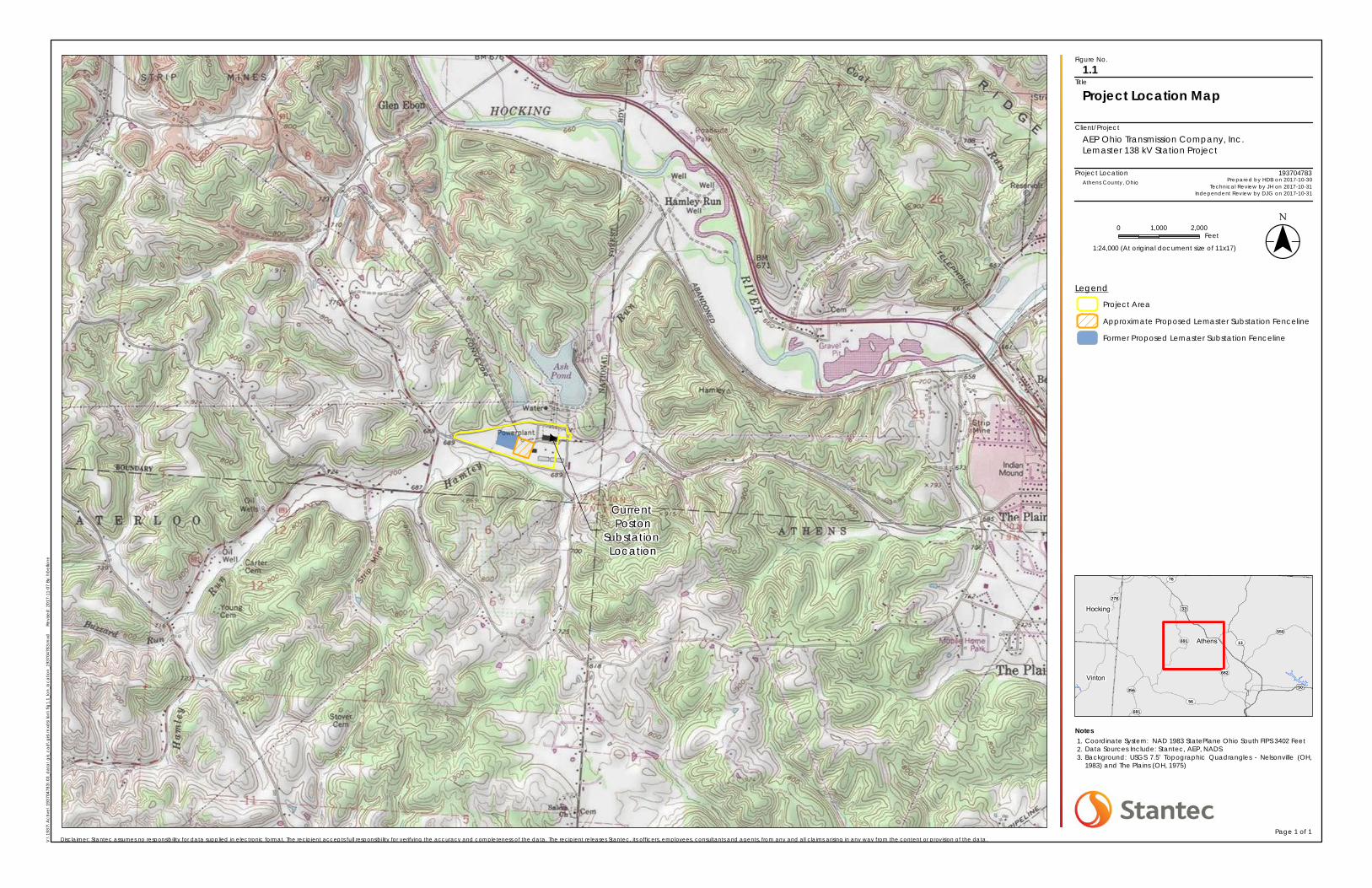
The location of the property is shown on Figure 1.1 in Appendix A. The new undeveloped, non-forested
property is approximately 41.75 acres in size. AEP Ohio Transco purchased the property for the Project.
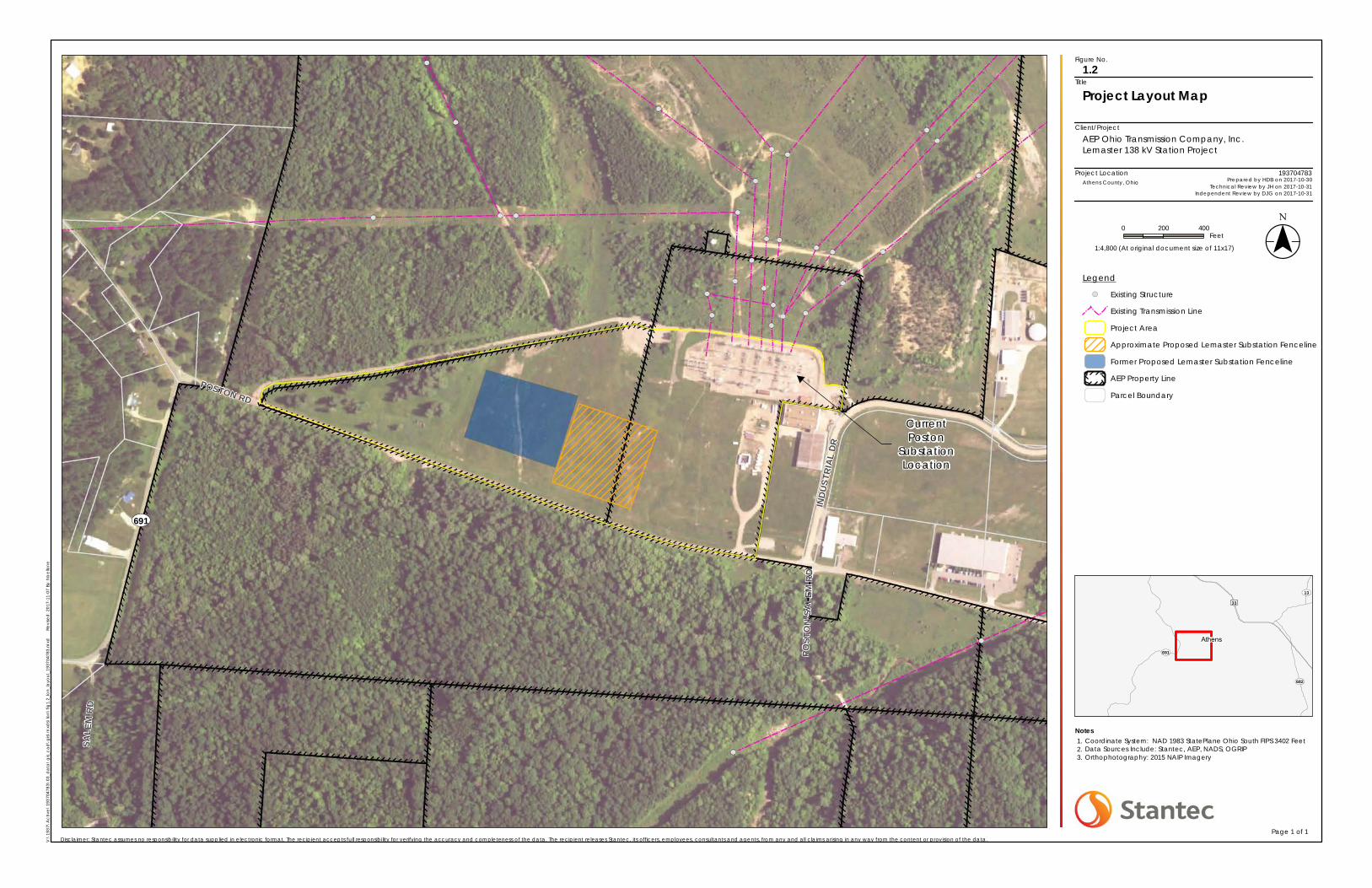
Figures 1.2 and 1.3 in Appendix A show the existing Poston Station and the general location of the
proposed Lemaster Station within the Project Area. At a later date, AEP Ohio Transco will submit
separate applications to the OPSB for the relocation of electric transmission lines from the existing
Poston Station to the new Lemaster Station.
A LON for the Project was previously submitted to the OPSB on December 21, 2016, under PUCO Case
No. 16-2314-EL-BLN. The location of the proposed substation has shifted slightly since that filing and is
now proposed to be located slightly east of the location outlined in the December 2016 LON. The
location of the previously proposed substation and newly proposed substation are shown on Figures 1.1
and 1.2 in Appendix A.
AEP Ohio Transco’s engineering contractor for the Project reviewed the existing topography and
geotechnical information provided by AEP Ohio Transco for the Project Area. AEP Ohio Transco
requested that the contractor consider mitigation of potential flooding risks on site when designing the
Lemaster Station facility. It was their assessment that it would be ideal for the long-term flood avoidance

AEP Ohio Transmission Company, Inc. November 7, 2017
Lemaster 138 kV Station Update 17-2281-EL-BLN
2
LETTER OF NOTIFICATION FOR LEMASTER 138 KV STATION UPDATE
of the facility to move the proposed substation location easterly on the existing property in order to
minimize the impact of runoff coming onto the station pad from properties to the north. The contractor
has finalized the substation pad design, including diversion ditches, a retention pond, and a small
stormwater basin near the southwest corner of the substation. This basin will provide storm water
detention and act as a post-construction Best Management Practice (BMP) for runoff from the station
pad.
The Project meets the requirements for a Letter of Notification (“LON”) because it is within the
types of projects defined by Item (1)(a) of 4906-1-01 Appendix A Application Requirement Matrix For
Electric Power Transmission Lines. This item states:
(3) Constructing a new electric power transmission substation.
B(2) Statement of Need
If the proposed project is an electric power transmission line or natural gas transmission
line, a statement explaining the need for the proposed facility.
The Poston Substation, which will be retired and removed, has been subject to flooding in the past,
posing a safety concern. The existing substation site also increases the difficulty of maintaining and
repairing aging equipment that was installed in the 1940’s and 50’s. This equipment no longer complies
with AEP’s safety standards. The drivers for replacement of the equipment are age, dielectric strength
breakdown, short circuit strength breakdown, and accessory damage. The new substation will occupy
approximately 5 acres and cost approximately $13 million to construct. Grading, retention/detention
features, and access to the station will also be constructed on the property surrounding the 5 acre
station site. The substation would consist of one 138 kV to 12 kV transformer, four breaker strings, ten
138 kV breakers, two 138 kV capacitor banks, and a control building. AEP proposes to commence
construction in May 2017 and place the new substation in service by June 2018.
B(3) Project Location
The applicant shall provide the location of the project in relation to existing or proposed
lines and substations shown on an area system map of sufficient scale and size to show
existing and proposed transmission facilities in the project area.
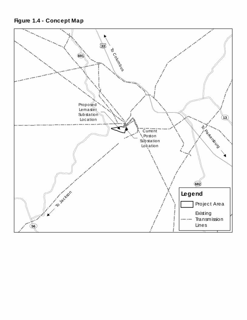
Figures 1.2, 1.3, and 1.4 in Appendix A show the location of the Project in relation to other existing AEP
Ohio Transco transmission lines and the existing Poston Station.
B(4) Alternatives Considered
The applicant shall describe the alternatives considered and reasons why the proposed
location or route is best suited for the proposed facility. The discussion shall include, but
not be limited to, impacts associated with socioeconomic, ecological, construction, or
engineering aspects of the project.

AEP Ohio Transmission Company, Inc. November 7, 2017
Lemaster 138 kV Station Update 17-2281-EL-BLN
3
LETTER OF NOTIFICATION FOR LEMASTER 138 KV STATION UPDATE
The proposed Project is located on property immediately adjacent to the existing Poston Station facility.
This property is currently undeveloped and non-forested, and does not contain any streams or wetlands.
There are no residences within 1,000 feet of the proposed Project location. This minimizes impacts to the
community and the environment, while taking into account the engineering and construction needs of the
Project. Therefore, no significant alternatives were studied as part of the Project. The study area for the
Project is the same as in the previously approved LON in PUCO Case No. 16-2314-EL-BLN.
B(5) Public Information Program
The applicant shall describe its public information program to inform affected property
owners and tenants of the nature of the project and the proposed timeframe for project
construction and restoration activities.
The Project will be located fully on property currently owned by AEP Ohio Transco. Within seven days of
filing this LON, AEP Ohio Transco will issue a public notice in a newspaper of general circulation in the
Project Area. The notice will comply with all requirements under O.A.C. Section 4906-6-08(A)(1-6).
Further, AEP Ohio Transco maintains a website (http://aeptransmission.com/ohio/) which provides the
public access to an electronic copy of this LON and the public notice for this LON. The LON will also be
sent to applicable public officials concurrently with submittal to OPSB, and a paper copy of the LON will
be provided to the Athens County Public Library.
B(6) Construction Schedule
The applicant shall provide an anticipated construction schedule and proposed in-service
date of the project.
Construction is planned to start in November/December 2017. The in-service date (completion date) of
the Project is expected to be on or about June 2018.
B(7) Area Map
The applicant shall provide a map of at least 1:24,000 scale clearly depicting the facility
with clearly marked streets, roads, and highways, and an aerial image.
Figure 1.1 included in Appendix A identifies the location of the Project Area on a USGS quadrangle map.
Figure 1.2 in Appendix A is an aerial map of the Project Area. To visit the Project from Columbus, take US
33 southeast to the State Route 682 interchange approximately four miles northeast of Athens, Ohio.
Take State Route 682 south for 0.25 miles and then turn right (west) on Poston Road (County Road 110).
Follow Poston Road west for approximately 2.75 miles. The Project Area is located on the north side of
the road.
B(8) Property Agreements
AEP Ohio Transmission Company, Inc. November 7, 2017
Lemaster 138 kV Station Update 17-2281-EL-BLN
4
LETTER OF NOTIFICATION FOR LEMASTER 138 KV STATION UPDATE
The applicant shall provide a list of properties for which the applicant has obtained
easements, options, and/or land use agreements necessary to construct and operate the
facility and a list of the additional properties for which such agreements have not been
obtained.
Construction of the new Lemaster Station will occur on property previously owned by the Athens County
Port Authority in York Township, Athens County (Parcel ID: P010010000104). AEP Ohio Transco
purchased the 41.75-acre parcel for construction of the station. No other property acquisition or easements
are required to construct and operate the Lemaster Station.
B(9) Technical Features
The applicant shall describe the following information regarding the technical features of
the Project:
B(9)(a) Operating characteristics, estimated number and types of structures required, and
right-of-way and/or land requirements.
The proposed Lemaster Station will be constructed on a 29.15-acre property. AEP Ohio Transco intends
to construct an approximate 5.0 acre station, adjacent storm water facilities, and access roads on this
property. The equipment and facilities described below will be installed within the fenced area of the
proposed Lemaster Station facility.
Breakers
There will be ten 138 kV breakers and two 138kV “cap-switchers” installed at the substation. These
breakers will be SF6 (sulfur hexafluoride) gas insulated, dead tank breakers.
Switchgear
The station is designed as a 138 kV breaker-and-a-half design, with an initial installation of four strings.
Bus Arrangement and Structures
The Project will be installed as follows: There will be a 138 kV four-string breaker-and-a-half layout with
six 138 kV line terminations (expandable to seven). Two 138 kV capacitor banks will attach to the two
138 kV buses, via a cap-switcher and disconnect switches. Equipment support steel structures will be
constructed using structural tubing, folded plate tapered tubular, and/or wide flange structures. There
will be a six bay 138 kV A-Frame dead-end expandable to seven. All yard structures will be ASTM A36,
ASTM A500, or ASTM A572 steel hot-dip galvanized for corrosion protection. The high bus throughout
the yard will be approximately 34 feet in height.
Transformers
There will be one 138 kV to 12 kV transformer installed at the substation.

AEP Ohio Transmission Company, Inc. November 7, 2017
Lemaster 138 kV Station Update 17-2281-EL-BLN
5
LETTER OF NOTIFICATION FOR LEMASTER 138 KV STATION UPDATE
Control Buildings
A single story, prefabricated control building, approximately 26 feet by 60 feet in dimension, will be
installed.
Other Major Equipment
Other equipment will include two 138 kV capacitor banks (28.8 MVAR each), surge arresters, Capacitor
Voltage Transformers (“CVTs”), line traps, station service equipment, and disconnect switches.
B(9)(b) Electric and Magnetic Fields
For electric power transmission lines that are within one hundred feet of an occupied
residence or institution, the production of electric and magnetic fields during the
operation of the proposed electric power transmission line. The discussion shall include:
B(9)(b)(i) Calculated Electric and Magnetic Field Strength Levels
This section is not applicable. The proposed Project is an electric transmission substation and there are
no occupied residences or institutions located within 100 feet of the Project.
B(9)(b)(ii) Design Alternatives
A discussion of the applicant's consideration of design alternatives with respect to electric
and magnetic fields and their strength levels, including alternate conductor configuration
and phasing, tower height, corridor location, and right-of-way width.
This section is not applicable. The proposed Project is an electric transmission substation and there are
no occupied residences or institutions located within 100 feet of the Project.
B(9)(b)(ii)(c) Project Costs
The estimated capital cost of the project.
The 2018 estimated capital cost of the proposed Project is $13,028,669.
B(10) Social and Economic Impacts
The applicant shall describe the social and ecological impacts of the project.
B(10)(a) Provide a brief, general description of land use within the vicinity of the proposed
project, including a list of municipalities, townships, and counties affected.
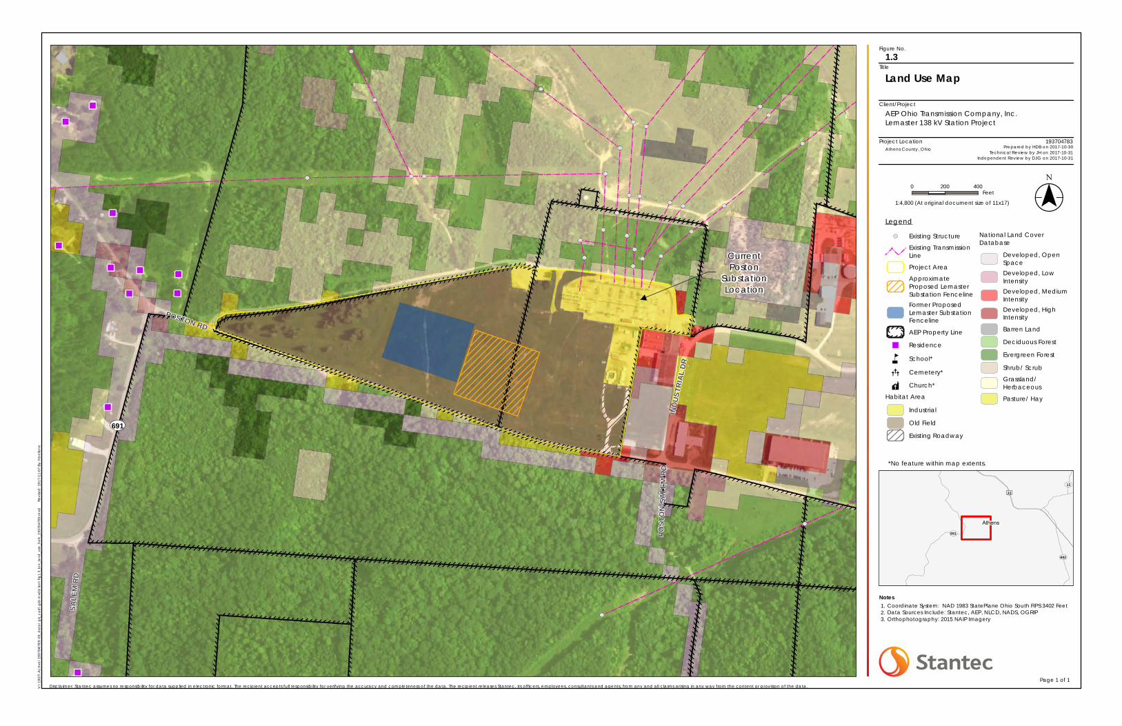
The Project is located within York Township, Athens County, Ohio. Figure 1.3 in Appendix A shows land
use categories documented within the Project Area, as well as the U.S. Department of Agriculture
AEP Ohio Transmission Company, Inc. November 7, 2017
Lemaster 138 kV Station Update 17-2281-EL-BLN
6
LETTER OF NOTIFICATION FOR LEMASTER 138 KV STATION UPDATE
(“USDA”) land use categories for areas surrounding the Project Area. According to this map, land uses in
the Project Area consist of old field habitats, industrial areas, and exiting roadways, while land uses in the
areas surrounding the Project Area consist of pasture/hayfield, grassland, barren land, and deciduous
forest. Field observations by AEP Ohio Transco’s consultant indicate the Project Area is primarily
comprised of old field habitat, which can be characterized as non-forested grassland that is occasionally
disturbed (mowed, grazed, or cleared) and contains a variety of herbaceous species, young shrubs, and
tree saplings. No streams or wetlands are located in the Project Area.
There are currently no active residences, cemeteries, churches, schools, or other community facilities
located within 1,000 feet of the proposed Lemaster Station location (as shown on Figures 1.2 and 1.3 in
Appendix A). The nearest residences are located approximately 1,700 feet to the west of the proposed
substation location along State Route 691 (see Figure 1.3). A water filtration plant is located
approximately 0.5 miles to the northeast of the Project (approximately 1,000 feet northeast of the existing
Poston Station).
No wildlife management areas or nature preserve lands are located within 1,000 feet of the Project.
However, the Wayne National Forest, the Hamley Run Floodplain Forest Conservation Site, a Breeding
Amphibian Site, a Floodplain Forest Plant Community, and a Mixed Mesophytic Forest Plant Community
were reported by the Ohio Department of Natural Resources (“ODNR”) Ohio Natural Heritage Program
(“ONHP”) as occurring within one mile of the Project Area (see Appendix C). The proposed Project will
not impact any of these resources.
B(10)(b) Agricultural Land Information
Provide the acreage and a general description of all agricultural land, and separately all
agricultural district land, existing at least sixty days prior to submission of the application
within the potential disturbance area of the project.
The Project is not located within registered agricultural district lands, based on December 9, 2016
coordination with the Athens County Auditor’s Office. Additionally, the Project Area does not contain any
active agricultural row crop land (see Figure 1.3 in Appendix A and Figure 3 in Appendix C).
B(10)(c) Archaeological and Cultural Resources
Provide a description of the applicant's investigation concerning the presence or absence
of significant archeological or cultural resources that may be located within the potential
disturbance area of the project, a statement of the findings of the investigation, and a copy
of any document produced as a result of the investigation.
In October 2016, AEP Ohio Transco’s consultant completed Phase I cultural resource investigations for
the Project (see Appendix B of the previously filed LON under PUCO Case No. 16-2314-EL-BLN). The
field investigations were conducted within the original Project Area (41.75 acres) Weller & Associates, Inc.
verified field investigations on the Poston Substation portion of the Project Area related to the proposed
Lemaster Station adjustment on October 31, 2017. The Project plans are to slightly move the proposed
AEP Ohio Transmission Company, Inc. November 7, 2017
Lemaster 138 kV Station Update 17-2281-EL-BLN
7
LETTER OF NOTIFICATION FOR LEMASTER 138 KV STATION UPDATE
station location to the east. Weller had previously completed cultural resource management work for the
planned station area as it was proposed, which is just west of the currently planned area. The work
involved visual inspection of the subject area and shovel probing to verify the conditions. The field
investigations did not identify any cultural materials and the area was found to be fully and severely
disturbed by grading activity associated with coal mining and activities associated with the extant Poston
Station. Weller did not recommend any additional work for the Project.
The literature review conducted for the Project Area identified no previously recorded archaeological sites
within a one-mile radius of the Project Area, and one previously recorded architectural site - the EM
Poston Generating Station (ATH0063302; ca 1949), which is located adjacent to the Project Area. This
site is not regarded as being a significant cultural resource.
The archaeological field reconnaissance determined that the majority of the Project Area has been
severely altered and disturbed. However, testing in the western part of the cultural resources study area
west of the proposed Lemaster Station site identified a historic period site (33AT1057). This site may
have significant deposits, as several intact subsurface deposits were identified during shovel testing. It is
recommended that this site be avoided, otherwise a Phase II archaeological assessment is considered
appropriate. Provided 33AT1057 is avoided, no further work is considered to be necessary for this Project.
For more information, see the Phase I Cultural Resources Management Investigations report included in
Appendix B of the previously filed LON under PUCO Case No. 16-2314-EL-BLN. An addendum cultural
resources survey letter report has been prepared under separate cover.
B(10)(d) Local, State, and Federal Agency Correspondence
Provide a list of the local, state, and federal governmental agencies known to have
requirements that must be met in connection with the construction of the project, and a
list of documents that have been or are being filed with those agencies in connection with
siting and constructing the project.
A Notice of Intent was filed with the Ohio Environmental Protection Agency for authorization of
construction storm water discharges under General Permit OHC000004, and AEP Ohio Transco will
implement and maintain best management practices, as outlined in the project-specific Storm Water
Pollution Prevention Plan (“SWPPP”), to minimize erosion and control sediment to protect surface water
quality during storm events. The Project will not impact any streams or wetlands, and no tree clearing
will be required in any forested wetlands (see Appendix C). In addition, the Project will not require a
Clean Water Act Section 404 Permit from the U.S. Army Corps of Engineers or Pre-Construction
Notification to the U.S. Army Corps of Engineers.
The Project is not located within a Federal Emergency Management Agency (“FEMA”) 100-year
floodplain area. Therefore, no floodplain permitting is required for the Project. There are no other
known local, state or federal requirements that must be met prior to commencement of the Project.
B(10)(e) Threatened, Endangered, and Rare Species
AEP Ohio Transmission Company, Inc. November 7, 2017
Lemaster 138 kV Station Update 17-2281-EL-BLN
8
LETTER OF NOTIFICATION FOR LEMASTER 138 KV STATION UPDATE
Provide a description of the applicant's investigation concerning the presence or absence
of federal and state designated species (including endangered species, threatened species,
rare species, species proposed for listing, species under review for listing, and species of
special interest) that may be located within the potential disturbance area of the project, a
statement of the findings of the investigation, and a copy of any document produced as a
result of the investigation.
The United States Fish and Wildlife Service (“USFWS”) Federally Listed Species by Ohio Counties
October 2015 (available at www.fws.gov/midwest/ohio/pdf/OhioTEListByCountyOct2015.pdf) was
reviewed to determine the threatened and endangered species currently known to occur in Athens County.
This USFWS publication listed the following threatened or endangered species as occurring in Athens
County: Indiana bat (Myotis sodalis; federally endangered), northern long-eared bat (Myotis
septentrionalis; federally threatened), fanshell (Cyprogenia stegaria; federally endangered), sheepnose
(Plethobasus cyphyus; federally endangered), pink mucket pearly mussel (Lampsilis orbiculata; federally
endangered), snuffbox (Epioblasma triquetra; federally endangered), and American burying beetle
(Nicrophorus americanus; federally endangered). As part of the ecological study completed for the
Project, a coordination letter was submitted to the USFWS Ohio Ecological Services Field Office seeking
technical assistance on the Project for potential impacts to threatened or endangered species. The
November 28, 2016 response letter from USFWS (see Appendix B) indicated that the proposed Project is
within the range of the Indiana bat and northern long-eared bat in Ohio, and within the vicinity of one or
more confirmed records of Indiana bats, but if tree clearing occurs between October 1 and March 31, they
do not anticipate the Project having any adverse effects to these species or any other federally listed
endangered, threatened, proposed, or candidate species. The proposed Project is not expected to require
any tree clearing. The USFWS letter did not include any comments specific to the other federally listed
species.
Several state-listed threatened species, endangered species, and species of concern are listed by the Ohio
Department of Natural Resources as occurring, or potentially occurring in Athens County.
(http://wildlife.ohiodnr.gov/portals/wildlife/pdfs/species%20and%20habitats/state-
listed%20species/athens.pdf) These state-listed species are addressed in detail in the Ecological
Resources Inventory Report included in Appendix B.
Coordination letters were submitted via email to the Ohio Department of Natural Resources (“ODNR”)
Division of Wildlife (“DOW”) Ohio Natural Heritage Program (“ONHP”) and the ODNR Office of Real
Estate in November 2016, seeking an environmental review of the proposed Project for potential impacts
on state-listed and federally-listed threatened or endangered species. Correspondence from ODNR’s
DOW/OHNP was received on November 17, 2016 and correspondence from the ODNR Office of Real
Estate was received on December 30, 2016 (see Appendix B).
According to the ODNR Office of Real Estate, the Project is within the vicinity of records for the Indiana
bat and presence of the Indiana bat has been established in the area. If suitable habitat occurs within the
project area, the ODNR recommends trees be conserved. If suitable habitat occurs within the project area
and trees must be cut, the ODNR recommends cutting occur between October 1 and March 31. If no tree
removal is proposed, this Project is not likely to impact this species. The ODNR Office of Real Estate also
AEP Ohio Transmission Company, Inc. November 7, 2017
Lemaster 138 kV Station Update 17-2281-EL-BLN
9
LETTER OF NOTIFICATION FOR LEMASTER 138 KV STATION UPDATE
indicated that due to the Project location, and that there is no in-water work proposed in a perennial
stream of sufficient size, this project is not likely to impact federal and state-listed mussel species. The
Project is also within the range of the channel darter (Percina copelandi), a state threatened fish, and the
river darter (Percina shumardi), a state threatened fish. The ODNR Office of Real Estate recommends no
in-water work in perennial streams from April 15 to June 30 to reduce impacts to indigenous aquatic
species and their habitat. If no in-water work is proposed, this Project is not likely to impact these or other
aquatic species. The Project is also within the range of the timber rattlesnake (Crotalus horridus
horridus), a state endangered species and a federal species of concern, the eastern spadefoot toad
(Scaphiopus holbrookii), a state endangered species, mud salamander (Pseudotriton montanus), a state
threatened species, and black bear (Ursus americanus), a state endangered species. The ODNR Office of
Real Estate indicated that due to the location, the type of habitat present at the project site, and the type
of work proposed, this Project is not likely to impact these species.
According to the DOW/OHNP, three species are known to occur within a one-mile radius of the Project
Area, including rough boneset (Eupatorium pilosum; status not yet determined), a caddisfly
(Brachycentrus numerosus; state endangered), and eastern box turtle (Terrapene carolina; state species
of concern). None of these known locations is within or in the immediate vicinity of the Project Area and
no impacts to these species are anticipated (see Appendix C for further information). Potentially suitable
habitat for two other state-listed species, black bear (Ursus americanus; state endangered) and timber
rattlesnake (Crotalus horridus horridus; state endangered) were observed in the Project Area. However,
neither of species is known to occur within a mile of the Project Area, and no impacts to these species are
anticipated (see Appendix B for further information).
B(10)(f) Areas of Ecological Concern
Provide a description of the applicant's investigation concerning the presence or absence
of areas of ecological concern (including national and state forests and parks, floodplains,
wetlands, designated or proposed wilderness areas, national and state wild and scenic
rivers, wildlife areas, wildlife refuges, wildlife management areas, and wildlife
sanctuaries) that may be located within the potential disturbance area of the project, a
statement of the findings of the investigation, and a copy of any document produced as a
result of the investigation.
The ODNR DOW/OHNP response indicated that they are unaware of any unique geological features or
scenic rivers within a mile of the Project Area, but did state that the Wayne National Forest, the Hamley
Run Floodplain Forest Conservation Site, a Breeding Amphibian Site, a Floodplain Forest Plant
Community, and a Mixed Mesophytic Forest Plant Community exist within a one-mile radius of the
Project. However, none of these known locations occur within or immediately adjacent to the Project
Area and no impacts are anticipated (see Appendix B). Correspondence received from the USFWS (see
Appendix B) indicated that there are no federal wilderness areas, wildlife refuges, or designated critical
habitat in the Project vicinity.
The FEMA Flood Insurance Rate Map (“FIRM”) was consulted to identify any floodplains/flood hazard
areas that have been mapped in the Project Area (specifically, map number 39009C0095C). Based on this
AEP Ohio Transmission Company, Inc. November 7, 2017
Lemaster 138 kV Station Update 17-2281-EL-BLN
10
LETTER OF NOTIFICATION FOR LEMASTER 138 KV STATION UPDATE
map, no mapped FEMA floodplains are located in the Project Area. Therefore, no floodplain permits will
be required for this Project.
A review of the National Wetlands Inventory (“NWI”) database indicated that one NWI-mapped wetland
was identified within the Project Area. Wetland and stream delineation field surveys were completed
within the Project Area by AEP Ohio Transco’s consultant in November 2016. The results of the wetland
and stream delineations are presented in the Ecological Resources Inventory Report included in Appendix
B. No wetlands or streams were identified in the Project Area. The area identified by the NWI as a
wetland within the Project Area was found to lack the necessary criteria to be considered a wetland.
Therefore, no impacts are anticipated during Project construction activities.
B(10)(g) Unusual Conditions
Provide any known additional information that will describe any unusual conditions
resulting in significant environmental, social, health, or safety impacts.
To the best of AEP Ohio Transco’s knowledge, no unusual conditions exist that would result in significant
environmental, social, health, or safety impacts.

LETTER OF NOTIFICATION FOR LEMASTER 138 KV STATION UPDATE
Appendix A Project Maps
November 7, 2017
Project Maps Appendix A
Figures 1.1, 1.2, 1.3, and 1.4
Project Location
Client/Project
Figure No.
Title
ST356
ST78
ST56
ST682
ST681
ST550
ST691
ST278
ST13
£¤50
£¤33
Athens
Hocking
Vinton
Current Poston
Substation Location
Project Location Map1.1
AEP Ohio Transmission Company, Inc.Lemaster 138 kV Station Project
Notes1.2.3.
0 1,000 2,000Feet
V:\
1937
\Ac
tive
\193
7047
83\0
3_d
ata
\g
is_c
ad
\gis\
mxd
s\lo
n\fig
1.1_
lon_
loc
atio
n_19
3704
783.
mxd
Revi
sed
: 201
7-11
-07
By: h
be
llone
($$¯1:24,000 (At original document size of 11x17)
193704783
Disclaimer: Stantec assumes no responsibility for data supplied in electronic format. The recipient accepts full responsibility for verifying the accuracy and completeness of the data. The recipient releases Stantec, its officers, employees, consultants and agents, from any and all claims arising in any way from the content or provision of the data.Page 1 of 1
Athens County, Ohio Prepared by HDB on 2017-10-30Technical Review by JH on 2017-10-31
Independent Review by DJG on 2017-10-31
Legend
Project Area
Approximate Proposed Lemaster Substation Fenceline
Former Proposed Lemaster Substation Fenceline
Coordinate System: NAD 1983 StatePlane Ohio South FIPS 3402 FeetData Sources Include: Stantec, AEP, NADSBackground: USGS 7.5' Topographic Quadrangles - Nelsonville (OH,1983) and The Plains (OH, 1975)
Project Location
Client/Project
Figure No.
Title
ST682
ST691
ST13
£¤33
Athens
POST
ON-S
ALEM
RD
SALE
M RD
INDU
STRI
AL D
R
POSTON RD
ST691
Project Layout Map1.2
AEP Ohio Transmission Company, Inc.Lemaster 138 kV Station Project
Notes1.2.3.
0 200 400Feet
V:\
1937
\Ac
tive
\193
7047
83\0
3_d
ata
\g
is_c
ad
\gis\
mxd
s\lo
n\fig
1.2_
lon_
layo
ut_1
9370
4783
.mxd
Revi
sed
: 201
7-11
-07
By: h
be
llone
($$¯1:4,800 (At original document size of 11x17)
193704783
Disclaimer: Stantec assumes no responsibility for data supplied in electronic format. The recipient accepts full responsibility for verifying the accuracy and completeness of the data. The recipient releases Stantec, its officers, employees, consultants and agents, from any and all claims arising in any way from the content or provision of the data.Page 1 of 1
Athens County, Ohio Prepared by HDB on 2017-10-30Technical Review by JH on 2017-10-31
Independent Review by DJG on 2017-10-31
Legend
!( Existing Structure
Existing Transmission Line
Project Area
Approximate Proposed Lemaster Substation Fenceline
Former Proposed Lemaster Substation Fenceline
AEP Property Line
Parcel Boundary
Coordinate System: NAD 1983 StatePlane Ohio South FIPS 3402 FeetData Sources Include: Stantec, AEP, NADS, OGRIPOrthophotography: 2015 NAIP Imagery
CurrentPoston
SubstationLocation
Project Location
Client/Project
Figure No.
Title
ST682
ST691
ST13
£¤33
Athens
POST
ON-S
ALEM
RD
SALE
M RD
INDU
STRI
AL D
R
POSTON RD
ST691
Land Use Map1.3
AEP Ohio Transmission Company, Inc.Lemaster 138 kV Station Project
Notes1.2.3.
0 200 400Feet
V:\
1937
\Ac
tive
\193
7047
83\0
3_d
ata
\g
is_c
ad
\gis\
mxd
s\lo
n\fig
1.3_
lon_
land
_use
_ha
b_1
9370
4783
.mxd
Revi
sed
: 201
7-11
-07
By: h
bel
lone
($$¯1:4,800 (At original document size of 11x17)
193704783
Disclaimer: Stantec assumes no responsibility for data supplied in electronic format. The recipient accepts full responsibility for verifying the accuracy and completeness of the data. The recipient releases Stantec, its officers, employees, consultants and agents, from any and all claims arising in any way from the content or provision of the data.Page 1 of 1
Athens County, Ohio Prepared by HDB on 2017-10-30Technical Review by JH on 2017-10-31
Independent Review by DJG on 2017-10-31
Legend
!( Existing Structure
Existing TransmissionLine
Project Area
ApproximateProposed LemasterSubstation FencelineFormer ProposedLemaster SubstationFenceline
AEP Property Line
" Residence
n School*
ï Cemetery*
î Church*
Habitat Area
Industrial
Old Field
Existing Roadway
National Land CoverDatabase
Developed, OpenSpaceDeveloped, LowIntensityDeveloped, MediumIntensityDeveloped, HighIntensity
Barren Land
Deciduous Forest
Evergreen Forest
Shrub/ Scrub
Grassland/Herbaceous
Pasture/ Hay
Coordinate System: NAD 1983 StatePlane Ohio South FIPS 3402 FeetData Sources Include: Stantec, AEP, NLCD, NADS, OGRIPOrthophotography: 2015 NAIP Imagery
*No feature within map extents.
CurrentPoston
SubstationLocation
!
!
!
!
!
!
!!!
!
!
!
!
!
!
!
!
!
!
!
!
!
!
!
!
!
!
!
!
!
!
!
!
!
!
!
!
!
!
!
!
!
!
!
!
!
!
!
!
!
!
!
!
!
!
!
!
!
!
!
!
!
!
!
!
!
!
!
!
!
!
!
!
!
!
!
!
!
!
!
!
!
!
!
!
!
!
!
!
!
!
!
!
!
!
!
!
!!
!!
!!
!!
!!
!
!
!
!
!
!
!
!
!
!
!
!
!
!
!
!
!
!
!
!
!
!
!
!
!
!
!
!
!
!
!
!
!
!
!
!
!
!
!
!
!
!
!
!
!
!
!
!
!
!
!
!
!
!
!
!
!
!
!
!
!
!
!
!
!
!
!
!
!
!
!
!
!
!
!
!
!
!
!
!
!
!
!
!
!
!
!
!
!
!
!
!
!
!
!
!
!
!
!
!
!
!
!
!
!
!
!
!
!
!
!
!
!
!
!
!
!
!
!
!
!
!
!
!
!
!
!
!
!
!
!
!
!
!
!
!
!
!
!
!
!
!
!
!
!
!
!
!
!
!
!
!
!
!
!
!
!
!
!
!
!
!!
!
!
!
!
!
!
!
!
!
!
!
!
!
!
!
!
!
!
!
!
!
!
!
!
!
!
!
!
!
!
!
!
!
!
!!
!!
!!
!
!
!
!
!
!
!
!
!
!
!
!
!
!
!
!
!
!
!
!
!
!
!
!
!
!!!!!!!!!!!!!!!!!!!!!!!!!!!!!!!!!!!!!!!!!!!!
!
!
!
!
!!
!!
!!
!
!
!
!
!
!
!
!
!
!
!
!
!
!
!
!
!
!
!
!
!
!
!
!
!
!
!
!
!
!
!
!
!
!
!
!
!
!
!
!
!
!
!
!
! ! ! ! ! !
!
! !
!
!!
!
!
!!
!
!
!
!
!
!
!
!
!!
!
!!!
!
!
!
!
!
!
!
!
!
!
!
!
!
!
!
!
!
!
!
!
!
!
!
!!
!
!
!
!
!
!
!!
!
!
!
!
!
!
!
!
!
!
!
!
!
!
!
!!
!!
!!
!!
!!
!!
!!
!!
!!
!
!
!
!
!
!
!
!
!
!
!
!
!
!
!
!
!
!!
!!
!
!
!
!
!
!
!
!
!!
!
!
!
!
!
!
!
!
!
!
!
!
!
!
!
!
!
!!
!
!
!
!
!
!!
!
!
!
!
!
£¤33
ST691
ST13
ST682
ST56
LegendProject Area
! !
ExistingTransmissionLines
Proposed Lemaster SubstationLocation
Figure 1.4 - Concept Map
To Ja
ckson
To Parkersburg
To Colum
busCurrentPoston
SubstationLocation

LETTER OF NOTIFICATION FOR LEMASTER 138 KV STATION UPDATE
Appendix B Ecological Resources Inventory Report
November 6, 2017
Ecological Resources Inventory Report Appendix B
Lemaster 138 kV Station Project, Athens County, Ohio
Ecological Resources Inventory Report
Prepared for:
AEP Ohio Transmission Company, Inc. 700 Morrison Road Gahanna, Ohio 43230
Prepared by:
Stantec Consulting Services Inc. 11687 Lebanon Road Cincinnati, Ohio 45241
November 7, 2017

LEMASTER 138 KV STATION PROJECT, ATHENS COUNTY, OHIO
i
Table of Contents
1.0 INTRODUCTION ............................................................................................................. 1
2.0 METHODS ....................................................................................................................... 1 2.1 WETLAND DELINEATION .................................................................................................... 1 2.2 STREAM DELINEATION ....................................................................................................... 1 2.3 RARE SPECIES ..................................................................................................................... 2
3.0 RESULTS .......................................................................................................................... 3 3.1 TERRESTRIAL HABITAT ......................................................................................................... 3 3.2 WETLANDS .......................................................................................................................... 3 3.3 STREAMS ............................................................................................................................. 4 3.4 RARE, THREATENED, OR ENDANGERED SPECIES HABITAT ............................................ 5
4.0 CONCLUSIONS AND RECOMMENDATIONS ............................................................... 11
5.0 REFERENCES ................................................................................................................. 13
LIST OF TABLES Table 1. Vegetation Communities and Land Cover Found within the Lemaster 138 kV Station Project Area, Athens County, Ohio .............................................................................. 3 Table 2. Summary of Potential Ohio State-Listed Species within the Lemaster 138 kV Station Project Area, Athens County, Ohio .............................................................................. 5 Table 3. Summary of Potential Federally-Listed Species within the Lemaster 138kV Station Project Area, Athens County, Ohio ........................................................................................... 9
LIST OF APPENDICES
FIGURES ..................................................................................................... A.1 A.1 Figure 1 – Project Location Map.................................................................................. A.1 A.2 Figure 2 – Wetland and Waterbody Delineation Map ............................................. A.2 A.3 Figure 3 – Habitat Assessment Map ............................................................................ A.3
AGENCY CORRESPONDENCE .................................................................. B.1
REPRESENTATIVE PHOTOGRAPHS ............................................................. C.1
DATA FORMS ............................................................................................. D.1 D.1 Wetland Determination Data Forms ........................................................................... D.1

LEMASTER 138 KV STATION PROJECT, ATHENS COUNTY, OHIO
1
1.0 Introduction
AEP Ohio Transmission Company, Inc. (AEP) is proposing the construction of a new 138 kV electric transmission substation (Lemaster 138 kV Station) in Athens County, Ohio (Figure 1, Appendix A). The Project area was surveyed for wetlands, waterbodies, and potential threatened, endangered, and rare species habitat by Stantec Consulting Services, Inc. (Stantec) biologists on November 7 and 8, 2016. The approximate locations of features located up to approximately 50 feet outside of the Project area were also recorded during the field surveys, where landowner access was permitted. However, no data forms were collected on features that did not extend into the Project area. These features are shown on the Figure 2 maps in Appendix A as “approximate” wetlands, streams, and upland drainage features.
2.0 Methods
2.1 WETLAND DELINEATION
Prior to completing the field surveys, a desktop review of the Project area was conducted using U.S. Geological Survey (USGS) topographic mapping, National Wetlands Inventory (NWI) maps, U.S. Department of Agriculture (USDA) Natural Resources Conservation Service (NRCS) soil surveys, and aerial imagery mapping. Stantec completed a wetland delineation study in accordance with the Corps of Engineers Wetlands Delineation Manual (Environmental Laboratory 1987) and the Regional Supplement to the Corps of Engineers Wetland Delineation Manual: Eastern Mountains and Piedmont Region (Version 2.0) (USACE 2012). Wetland categories were classified using the Ohio Rapid Assessment Method (ORAM) for Wetlands Version 5.0 (Mack 2001).
2.2 STREAM DELINEATION
Streams that demonstrated a continuously defined channel (bed and bank), ordinary high water mark (OHWM), and the disturbance of terrestrial vegetation were delineated within the Project area, per the protocols outlined in the USACE’s Guidance on Ordinary High Water Mark Identification (Regulatory Guidance Letter, No. 05-05) (USACE 2005). Delineated streams were classified as ephemeral, intermittent, or perennial per definitions in the Federal Register/Vol. 67, No. 10 (USACE 2002). Functional assessment of streams within the Project area was based on completion of the Ohio Environmental Protection Agency’s (OEPA) Headwater Habitat Evaluation Index (HHEI) and/or Qualitative Habitat Evaluation Index (QHEI). The centerline of each waterway was identified and surveyed using a handheld sub-meter accuracy GPS unit and mapped with GIS software. Additionally, the locations of upland drainage features (which lacked a continuously defined bed and bank/OHWM) identified within the Project area were also recorded with a sub-meter accuracy GPS unit during the field surveys.
LEMASTER 138 KV STATION PROJECT, ATHENS COUNTY, OHIO
2
2.3 RARE SPECIES
Prior to conducting the field surveys, Stantec contacted the Ohio Department of Natural Resources (ODNR) and the U.S. Fish and Wildlife Service (USFWS) for information regarding rare, threatened, or endangered species and their habitats of concern within the vicinity of the Project area (Appendix B – Agency Correspondence). To assess potential impacts to rare, threatened, or endangered species, Stantec scientists conducted a pedestrian reconnaissance of the proposed Project area, collected information on existing habitats within the Project area, and assessed the potential for these habitats to be used by these species.

LEMASTER 138 KV STATION PROJECT, ATHENS COUNTY, OHIO
3
3.0 Results
3.1 TERRESTRIAL HABITAT
Stantec completed field surveys within the Project area on November 7 and 8, 2016, for wetlands, waterbodies, and threatened and endangered species or their habitats. Figure 2 (Appendix A) shows the wetlands and waterbodies identified by Stantec within the Project area, as well as the locations of upland drainage features identified within the Project area. Figure 3 (Appendix A) shows the habitats and locations of any identified rare, threatened, or endangered species habitat observed within the Project area during the rare, threatened, and endangered species habitat assessment surveys. Representative photographs of the wetlands, streams, upland drainage features, and other habitats identified within the Project area are included in Appendix C of this report (photo locations are shown on Figures 2 and 3, Appendix A).
Table 1. Vegetation Communities and Land Cover Found within the Lemaster 138 kV Station Project Area, Athens County, Ohio
Vegetation Communities and Land Cover Types within the Project Area
Degree of Human-Related Ecological Disturbance
Unique, Rare, or High
Quality?
Approximate Acreage Within
Project Area
Old Field
Extreme Disturbance/ Ruderal Community (dominated by
opportunistic invaders or native highly tolerant taxa)
No 33.72
Industrial Extreme Disturbance (existing roads and gravel parking lots) No 6.73
Existing Roadway Extreme Disturbance/existing gravel and/or paved road. No 1.30
Total 41.75
3.2 WETLANDS
No wetlands were identified within the Project area. However, one wetland determination sample point was taken within an NWI mapped palustrine scrub-shrub/emergent wetland (PSS/PEM) area (see Figure 2). The area did not meet the criteria to be considered a wetland. Completed wetland determination data forms for this sample point are included in Appendix D.

LEMASTER 138 KV STATION PROJECT, ATHENS COUNTY, OHIO
4
3.3 STREAMS
No streams were identified within the Project area.

LEMASTER 138 KV STATION PROJECT, ATHENS COUNTY, OHIO
5
3.4 RARE, THREATENED, OR ENDANGERED SPECIES HABITAT
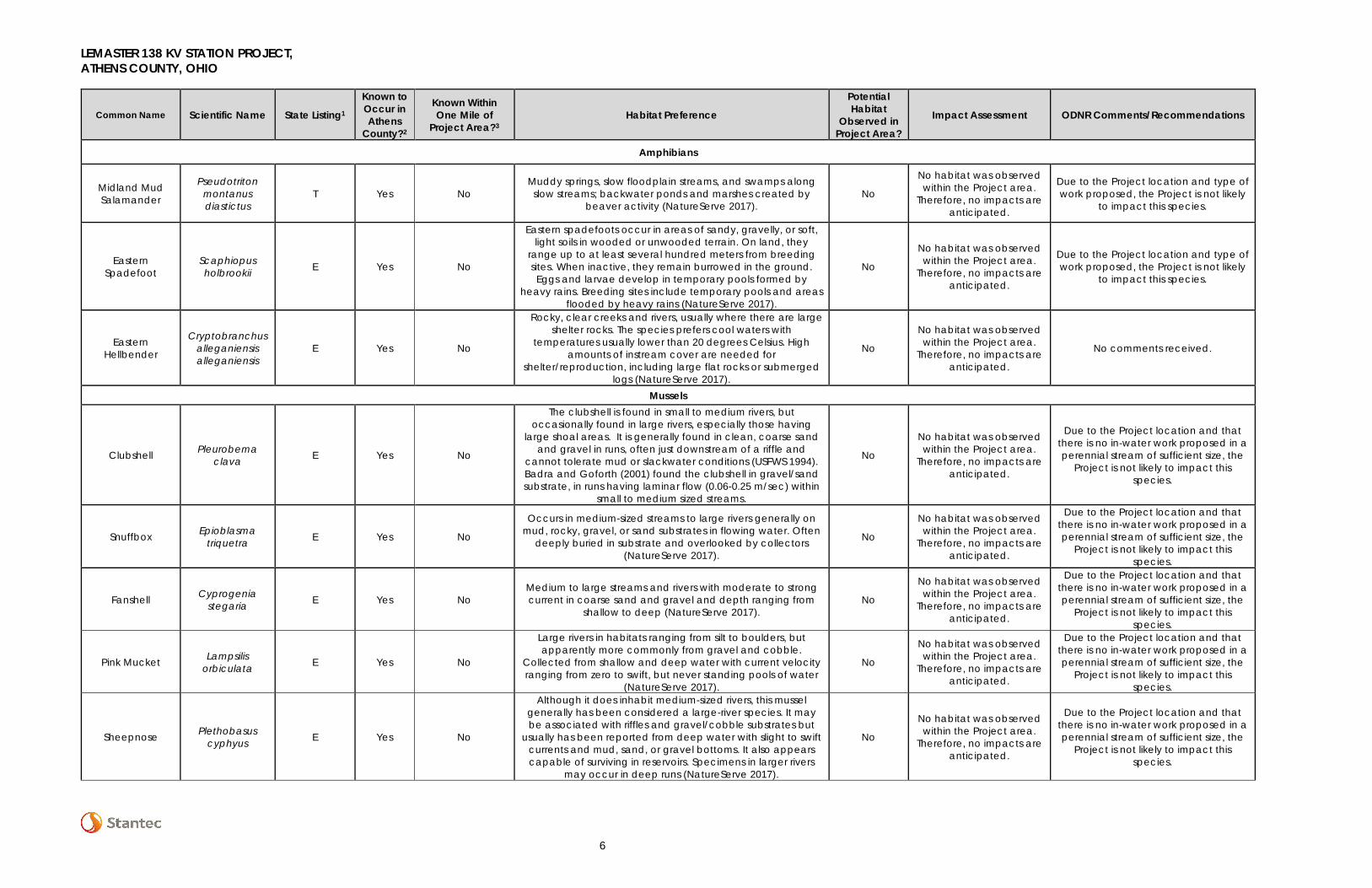
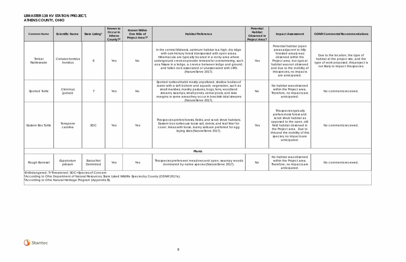
Table 2. Summary of Potential Ohio State-Listed Species within the Lemaster 138 kV Station Project Area, Athens County, Ohio
Common Name Scientific Name State Listing1
Known to Occur in Athens
County?2
Known Within One Mile of
Project Area?3 Habitat Preference
Potential Habitat
Observed in Project Area?
Impact Assessment ODNR Comments/Recommendations
Insects
Regal Fritillary Speyeria idalia E Yes No Occurs in tall grass prairie remnants (Butterflies and Moths of North America 2016). No
No habitat was observed within the Project area.
Therefore, no impacts are anticipated.
No comments received.
Grizzled Skipper Pyrgus
centaureae wyandot
E Yes No
This species is associated with openings in mature oak forests that support stands of Canada cinquefoil. Most of these areas are highly disturbed, and are characterized by fair
amounts of exposed soil and rock (ODNR 2017b).
No
No habitat was observed within the Project area.
Therefore, no impacts are anticipated.
No comments received.
American Burying Beetle
Nicrophorus americanus E Yes No
Current information suggests this species is a habitat generalist, or one that lives in many types of habitat, but with a slight preference for grasslands and the open understory of
oak-hickory forests (ODNR 2017b).
No
No habitat was observed within the Project area.
Therefore, no impacts are anticipated.
No comments received.
Caddisfly Brachycentrus numerosus E Yes Yes
Habitat preference has not been assessed at this time (NatureServe 2017), though caddisflies normally occur in
streams, rivers, and ponds. No
No habitat was observed within the Project area.
Therefore, no impacts are anticipated.
No comments received.
Marsh Fern Moth Fagitana littera T Yes No
This species typically occurs in unforested wetlands such as bogs, shrub swamps, and marshes. This species also occurs along wet powerlines and wet open pinelands (New York
Natural Heritage Program 2015).
No
No habitat was observed within the Project area.
Therefore, no impacts are anticipated.
No comments received.
Fishes
Channel Darter Etheostoma tippecanoe T Yes No
This fish prefers medium to large streams in the Ohio River drainage system and are found in riffles of moderate current with substrate of gravel or cobble sized rocks (ODNR 2017b).
No
No habitat was observed within the Project area.
Therefore, no impacts are anticipated.
ODNR recommends no in-water work in perennial streams from April 15 to
June 30 to reduce impacts to indigenous aquatic species and their
habitat. If no in-water work is proposed in a perennial stream, this
project is not likely to impact this species or other aquatic species.
River Darter Percina shumardi T Yes No
Large rivers and lower portions of tributaries; deep chutes and riffles where current is swift and substrates are coarse gravel
or rock (NatureServe 2017). No
No habitat was observed within the Project area.
Therefore, no impacts are anticipated.
ODNR recommends no in-water work in perennial streams from April 15 to
June 30 to reduce impacts to indigenous aquatic species and their
habitat. If no in-water work is proposed in a perennial stream, this
project is not likely to impact this species or other aquatic species.
LEMASTER 138 KV STATION PROJECT, ATHENS COUNTY, OHIO
6
Common Name Scientific Name State Listing1
Known to Occur in Athens
County?2
Known Within One Mile of
Project Area?3 Habitat Preference
Potential Habitat
Observed in Project Area?
Impact Assessment ODNR Comments/Recommendations
Amphibians
Midland Mud Salamander
Pseudotriton montanus diastictus
T Yes No Muddy springs, slow floodplain streams, and swamps along
slow streams; backwater ponds and marshes created by beaver activity (NatureServe 2017).
No
No habitat was observed within the Project area.
Therefore, no impacts are anticipated.
Due to the Project location and type of work proposed, the Project is not likely
to impact this species.
Eastern Spadefoot
Scaphiopus holbrookii E Yes No
Eastern spadefoots occur in areas of sandy, gravelly, or soft, light soils in wooded or unwooded terrain. On land, they
range up to at least several hundred meters from breeding sites. When inactive, they remain burrowed in the ground. Eggs and larvae develop in temporary pools formed by
heavy rains. Breeding sites include temporary pools and areas flooded by heavy rains (NatureServe 2017).
No
No habitat was observed within the Project area.
Therefore, no impacts are anticipated.
Due to the Project location and type of work proposed, the Project is not likely
to impact this species.
Eastern Hellbender
Cryptobranchus alleganiensis alleganiensis
E Yes No
Rocky, clear creeks and rivers, usually where there are large shelter rocks. The species prefers cool waters with
temperatures usually lower than 20 degrees Celsius. High amounts of instream cover are needed for
shelter/reproduction, including large flat rocks or submerged logs (NatureServe 2017).
No
No habitat was observed within the Project area.
Therefore, no impacts are anticipated.
No comments received.
Mussels
Clubshell Pleurobema clava E Yes No
The clubshell is found in small to medium rivers, but occasionally found in large rivers, especially those having
large shoal areas. It is generally found in clean, coarse sand and gravel in runs, often just downstream of a riffle and
cannot tolerate mud or slackwater conditions (USFWS 1994). Badra and Goforth (2001) found the clubshell in gravel/sand substrate, in runs having laminar flow (0.06-0.25 m/sec) within
small to medium sized streams.
No
No habitat was observed within the Project area.
Therefore, no impacts are anticipated.
Due to the Project location and that there is no in-water work proposed in a perennial stream of sufficient size, the
Project is not likely to impact this species.
Snuffbox Epioblasma triquetra E Yes No
Occurs in medium-sized streams to large rivers generally on mud, rocky, gravel, or sand substrates in flowing water. Often
deeply buried in substrate and overlooked by collectors (NatureServe 2017).
No
No habitat was observed within the Project area.
Therefore, no impacts are anticipated.
Due to the Project location and that there is no in-water work proposed in a perennial stream of sufficient size, the
Project is not likely to impact this species.
Fanshell Cyprogenia stegaria E Yes No
Medium to large streams and rivers with moderate to strong current in coarse sand and gravel and depth ranging from
shallow to deep (NatureServe 2017). No
No habitat was observed within the Project area.
Therefore, no impacts are anticipated.
Due to the Project location and that there is no in-water work proposed in a perennial stream of sufficient size, the
Project is not likely to impact this species.
Pink Mucket Lampsilis orbiculata E Yes No
Large rivers in habitats ranging from silt to boulders, but apparently more commonly from gravel and cobble.
Collected from shallow and deep water with current velocity ranging from zero to swift, but never standing pools of water
(NatureServe 2017).
No
No habitat was observed within the Project area.
Therefore, no impacts are anticipated.
Due to the Project location and that there is no in-water work proposed in a perennial stream of sufficient size, the
Project is not likely to impact this species.
Sheepnose Plethobasus cyphyus E Yes No
Although it does inhabit medium-sized rivers, this mussel generally has been considered a large-river species. It may be associated with riffles and gravel/cobble substrates but
usually has been reported from deep water with slight to swift currents and mud, sand, or gravel bottoms. It also appears capable of surviving in reservoirs. Specimens in larger rivers
may occur in deep runs (NatureServe 2017).
No
No habitat was observed within the Project area.
Therefore, no impacts are anticipated.
Due to the Project location and that there is no in-water work proposed in a perennial stream of sufficient size, the
Project is not likely to impact this species.
LEMASTER 138 KV STATION PROJECT, ATHENS COUNTY, OHIO
7
Common Name Scientific Name State Listing1
Known to Occur in Athens
County?2
Known Within One Mile of
Project Area?3 Habitat Preference
Potential Habitat
Observed in Project Area?
Impact Assessment ODNR Comments/Recommendations
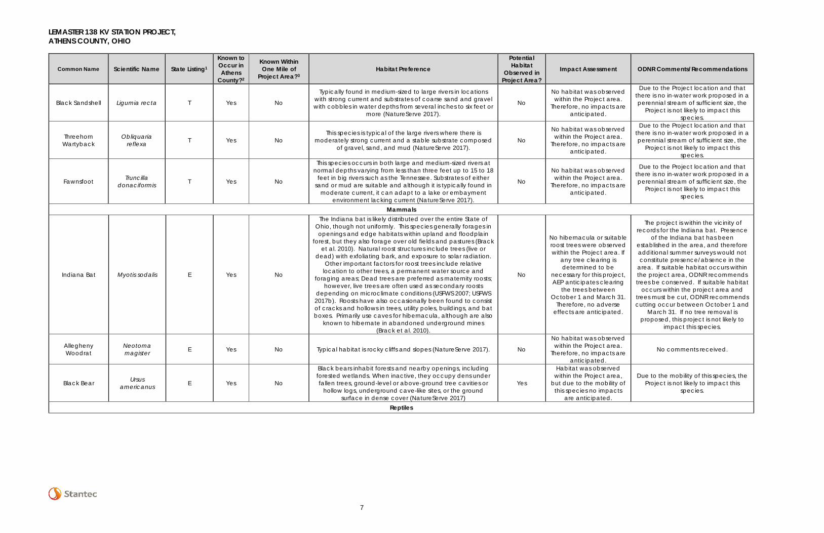
Black Sandshell Ligumia recta T Yes No
Typically found in medium-sized to large rivers in locations with strong current and substrates of coarse sand and gravel with cobbles in water depths from several inches to six feet or
more (NatureServe 2017).
No
No habitat was observed within the Project area.
Therefore, no impacts are anticipated.
Due to the Project location and that there is no in-water work proposed in a perennial stream of sufficient size, the
Project is not likely to impact this species.
Threehorn Wartyback
Obliquaria reflexa T Yes No
This species is typical of the large rivers where there is moderately strong current and a stable substrate composed
of gravel, sand, and mud (NatureServe 2017). No
No habitat was observed within the Project area.
Therefore, no impacts are anticipated.
Due to the Project location and that there is no in-water work proposed in a perennial stream of sufficient size, the
Project is not likely to impact this species.
Fawnsfoot Truncilla donaciformis T Yes No
This species occurs in both large and medium-sized rivers at normal depths varying from less than three feet up to 15 to 18
feet in big rivers such as the Tennessee. Substrates of either sand or mud are suitable and although it is typically found in
moderate current, it can adapt to a lake or embayment environment lacking current (NatureServe 2017).
No
No habitat was observed within the Project area.
Therefore, no impacts are anticipated.
Due to the Project location and that there is no in-water work proposed in a perennial stream of sufficient size, the
Project is not likely to impact this species.
Mammals
Indiana Bat Myotis sodalis E Yes No
The Indiana bat is likely distributed over the entire State of Ohio, though not uniformly. This species generally forages in openings and edge habitats within upland and floodplain
forest, but they also forage over old fields and pastures (Brack et al. 2010). Natural roost structures include trees (live or
dead) with exfoliating bark, and exposure to solar radiation. Other important factors for roost trees include relative
location to other trees, a permanent water source and foraging areas; Dead trees are preferred as maternity roosts;
however, live trees are often used as secondary roosts depending on microclimate conditions (USFWS 2007; USFWS 2017b). Roosts have also occasionally been found to consist of cracks and hollows in trees, utility poles, buildings, and bat boxes. Primarily use caves for hibernacula, although are also
known to hibernate in abandoned underground mines (Brack et al. 2010).
No
No hibernacula or suitable roost trees were observed within the Project area. If
any tree clearing is determined to be
necessary for this project, AEP anticipates clearing
the trees between October 1 and March 31.
Therefore, no adverse effects are anticipated.
The project is within the vicinity of records for the Indiana bat. Presence
of the Indiana bat has been established in the area, and therefore additional summer surveys would not constitute presence/absence in the
area. If suitable habitat occurs within the project area, ODNR recommends trees be conserved. If suitable habitat
occurs within the project area and trees must be cut, ODNR recommends cutting occur between October 1 and
March 31. If no tree removal is proposed, this project is not likely to
impact this species.
Allegheny Woodrat
Neotoma magister E Yes No Typical habitat is rocky cliffs and slopes (NatureServe 2017). No
No habitat was observed within the Project area.
Therefore, no impacts are anticipated.
No comments received.
Black Bear Ursus americanus E Yes No
Black bears inhabit forests and nearby openings, including forested wetlands. When inactive, they occupy dens under fallen trees, ground-level or above-ground tree cavities or
hollow logs, underground cave-like sites, or the ground surface in dense cover (NatureServe 2017)
Yes
Habitat was observed within the Project area,
but due to the mobility of this species no impacts
are anticipated.
Due to the mobility of this species, the Project is not likely to impact this
species.
Reptiles
LEMASTER 138 KV STATION PROJECT, ATHENS COUNTY, OHIO
8
Common Name Scientific Name State Listing1
Known to Occur in Athens
County?2
Known Within One Mile of
Project Area?3 Habitat Preference
Potential Habitat
Observed in Project Area?
Impact Assessment ODNR Comments/Recommendations
Timber Rattlesnake
Crotalus horridus horridus E Yes No
In the central Midwest, optimum habitat is a high, dry ridge with oak-hickory forest interspersed with open areas.
Hibernacula are typically located in a rocky area where underground crevices provide retreats for overwintering, such as a fissure in a ledge, a crevice between ledge and ground,
and fallen rock associated or unassociated with cliffs (NatureServe 2017).
Yes
Potential habitat (open areas adjacent to hilly
forested areas) was observed within the
Project area, but typical habitat was not observed and due to the mobility of
this species, no impacts are anticipated.
Due to the location, the type of habitat at the project site, and the
type of work proposed, this project is not likely to impact this species.
Spotted Turtle Clemmys guttata T Yes No
Spotted turtles inhabit mostly unpolluted, shallow bodies of water with a soft bottom and aquatic vegetation, such as
small marshes, marshy pastures, bogs, fens, woodland streams, swamps, small ponds, vernal pools, and lake
margins: in some areas they occur in brackish tidal streams (NatureServe 2017).
No
No habitat was observed within the Project area.
Therefore, no impacts are anticipated.
No comments received.
Eastern Box Turtle Terrapene carolina SOC Yes Yes
This species prefers forests, fields, and scrub shrub habitats. Eastern box turtles use loose soil, debris, and leaf litter for cover. Areas with loose, loamy soils are preferred for egg
laying sites (NatureServe 2017).
Yes
This species typically prefers moist forest and scrub shrub habitat as
opposed to the open, old field habitat observed in the Project area. Due to
this and the mobility of this species, no impacts are
anticipated.
No comments received.
Plants
Rough Boneset Eupatorium pilosum
Status Not Detrmined Yes Yes This species prefers wet meadows and open, swampy woods
dominated by native species (NatureServe 2017). No
No habitat was observed within the Project area.
Therefore, no impacts are anticipated.
No comments received.
1E=Endangered; T=Threatened; SOC=Species of Concern 2According to Ohio Department of Natural Resources, State Listed Wildlife Species by County (ODNR 2017a). 3According to Ohio Natural Heritage Program (Appendix B).
LEMASTER 138 KV STATION PROJECT, ATHENS COUNTY, OHIO
9
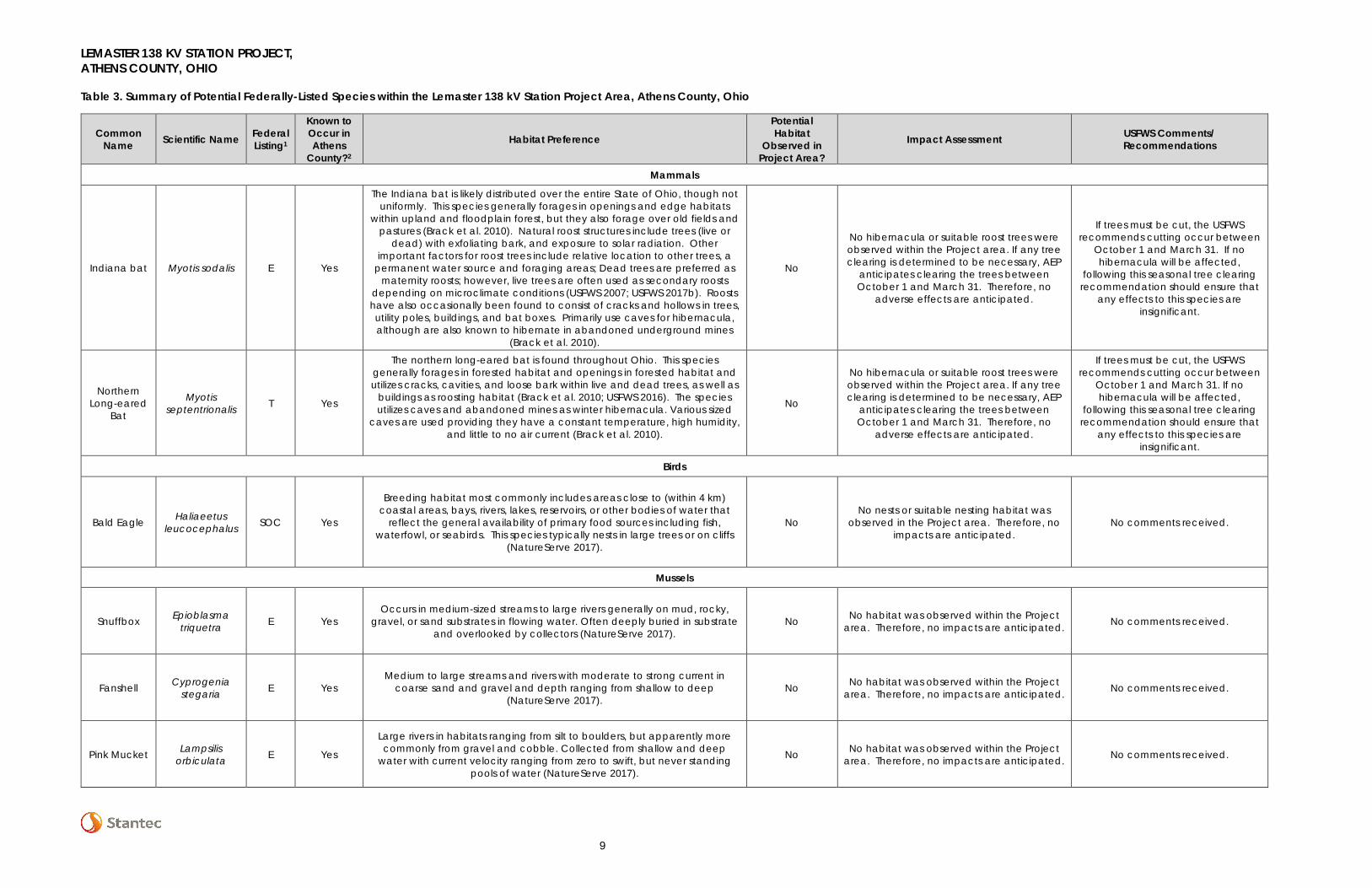
Table 3. Summary of Potential Federally-Listed Species within the Lemaster 138 kV Station Project Area, Athens County, Ohio
Common Name Scientific Name Federal
Listing1
Known to Occur in Athens
County?2
Habitat Preference
Potential Habitat
Observed in Project Area?
Impact Assessment USFWS Comments/ Recommendations
Mammals
Indiana bat Myotis sodalis E Yes
The Indiana bat is likely distributed over the entire State of Ohio, though not uniformly. This species generally forages in openings and edge habitats
within upland and floodplain forest, but they also forage over old fields and pastures (Brack et al. 2010). Natural roost structures include trees (live or
dead) with exfoliating bark, and exposure to solar radiation. Other important factors for roost trees include relative location to other trees, a
permanent water source and foraging areas; Dead trees are preferred as maternity roosts; however, live trees are often used as secondary roosts
depending on microclimate conditions (USFWS 2007; USFWS 2017b). Roosts have also occasionally been found to consist of cracks and hollows in trees, utility poles, buildings, and bat boxes. Primarily use caves for hibernacula, although are also known to hibernate in abandoned underground mines
(Brack et al. 2010).
No
No hibernacula or suitable roost trees were observed within the Project area. If any tree clearing is determined to be necessary, AEP
anticipates clearing the trees between October 1 and March 31. Therefore, no
adverse effects are anticipated.
If trees must be cut, the USFWS recommends cutting occur between
October 1 and March 31. If no hibernacula will be affected,
following this seasonal tree clearing recommendation should ensure that
any effects to this species are insignificant.
Northern Long-eared
Bat
Myotis septentrionalis T Yes
The northern long-eared bat is found throughout Ohio. This species generally forages in forested habitat and openings in forested habitat and utilizes cracks, cavities, and loose bark within live and dead trees, as well as
buildings as roosting habitat (Brack et al. 2010; USFWS 2016). The species utilizes caves and abandoned mines as winter hibernacula. Various sized
caves are used providing they have a constant temperature, high humidity, and little to no air current (Brack et al. 2010).
No
No hibernacula or suitable roost trees were observed within the Project area. If any tree clearing is determined to be necessary, AEP
anticipates clearing the trees between October 1 and March 31. Therefore, no
adverse effects are anticipated.
If trees must be cut, the USFWS recommends cutting occur between
October 1 and March 31. If no hibernacula will be affected,
following this seasonal tree clearing recommendation should ensure that
any effects to this species are insignificant.
Birds
Bald Eagle Haliaeetus leucocephalus SOC Yes
Breeding habitat most commonly includes areas close to (within 4 km) coastal areas, bays, rivers, lakes, reservoirs, or other bodies of water that
reflect the general availability of primary food sources including fish, waterfowl, or seabirds. This species typically nests in large trees or on cliffs
(NatureServe 2017).
No No nests or suitable nesting habitat was
observed in the Project area. Therefore, no impacts are anticipated.
No comments received.
Mussels
Snuffbox Epioblasma triquetra E Yes
Occurs in medium-sized streams to large rivers generally on mud, rocky, gravel, or sand substrates in flowing water. Often deeply buried in substrate
and overlooked by collectors (NatureServe 2017). No No habitat was observed within the Project
area. Therefore, no impacts are anticipated. No comments received.
Fanshell Cyprogenia stegaria E Yes
Medium to large streams and rivers with moderate to strong current in coarse sand and gravel and depth ranging from shallow to deep
(NatureServe 2017). No No habitat was observed within the Project
area. Therefore, no impacts are anticipated. No comments received.
Pink Mucket Lampsilis orbiculata E Yes
Large rivers in habitats ranging from silt to boulders, but apparently more commonly from gravel and cobble. Collected from shallow and deep
water with current velocity ranging from zero to swift, but never standing pools of water (NatureServe 2017).
No No habitat was observed within the Project area. Therefore, no impacts are anticipated. No comments received.
LEMASTER 138 KV STATION PROJECT, ATHENS COUNTY, OHIO
10
Common Name Scientific Name Federal
Listing1
Known to Occur in Athens
County?2
Habitat Preference
Potential Habitat
Observed in Project Area?
Impact Assessment USFWS Comments/ Recommendations
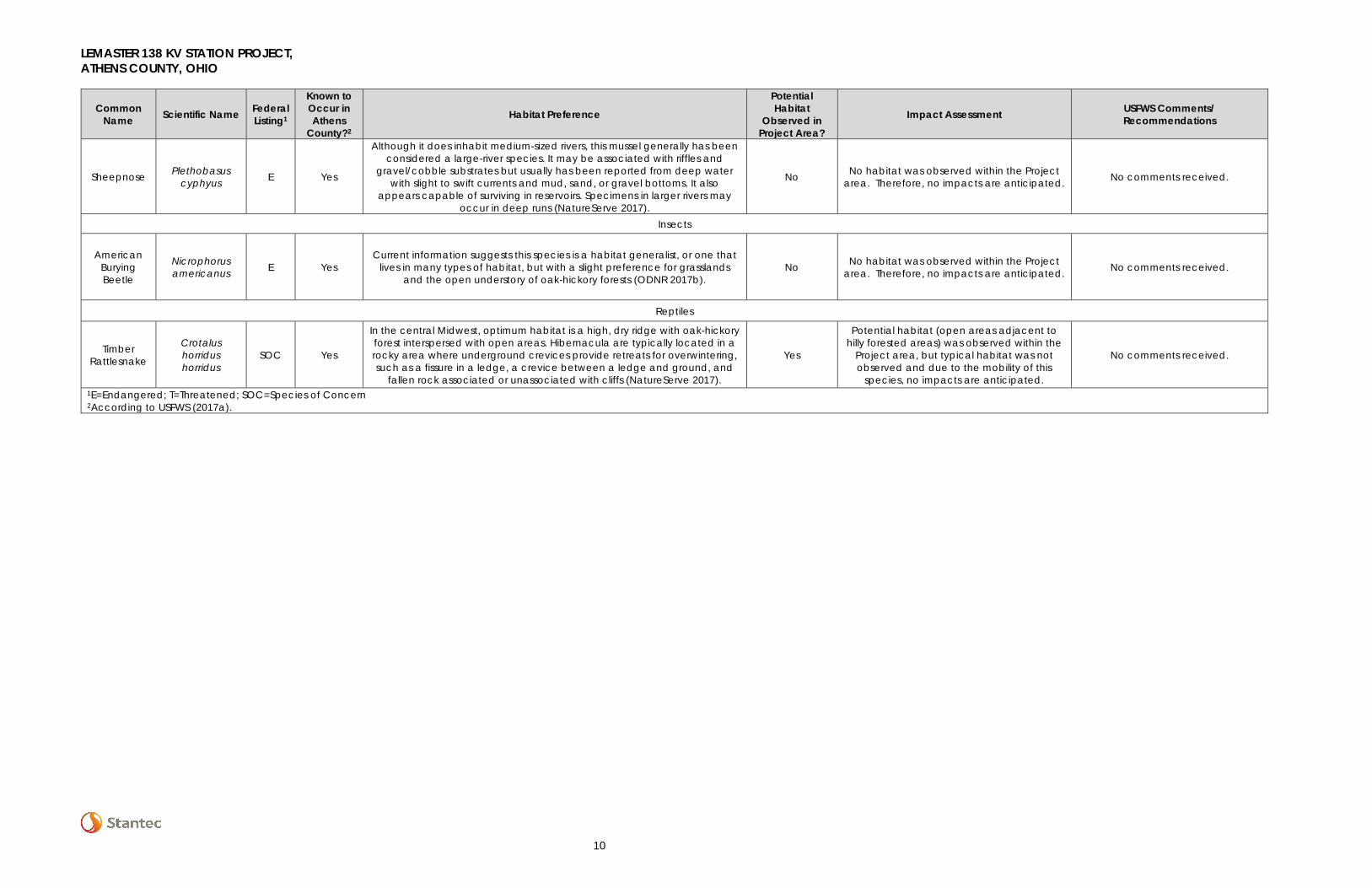
Sheepnose Plethobasus cyphyus E Yes
Although it does inhabit medium-sized rivers, this mussel generally has been considered a large-river species. It may be associated with riffles and
gravel/cobble substrates but usually has been reported from deep water with slight to swift currents and mud, sand, or gravel bottoms. It also
appears capable of surviving in reservoirs. Specimens in larger rivers may occur in deep runs (NatureServe 2017).
No No habitat was observed within the Project area. Therefore, no impacts are anticipated. No comments received.
Insects
American Burying Beetle
Nicrophorus americanus E Yes
Current information suggests this species is a habitat generalist, or one that lives in many types of habitat, but with a slight preference for grasslands
and the open understory of oak-hickory forests (ODNR 2017b). No No habitat was observed within the Project
area. Therefore, no impacts are anticipated. No comments received.
Reptiles
Timber Rattlesnake
Crotalus horridus horridus
SOC Yes
In the central Midwest, optimum habitat is a high, dry ridge with oak-hickory forest interspersed with open areas. Hibernacula are typically located in a rocky area where underground crevices provide retreats for overwintering, such as a fissure in a ledge, a crevice between a ledge and ground, and
fallen rock associated or unassociated with cliffs (NatureServe 2017).
Yes
Potential habitat (open areas adjacent to hilly forested areas) was observed within the
Project area, but typical habitat was not observed and due to the mobility of this
species, no impacts are anticipated.
No comments received.
1E=Endangered; T=Threatened; SOC=Species of Concern 2According to USFWS (2017a).
LEMASTER 138 KV STATION PROJECT, ATHENS COUNTY, OHIO
11
4.0 Conclusions and Recommendations
Stantec conducted a wetland and waterbodies delineation and a preliminary habitat assessment for threatened and endangered species or their habitats within the Project area on November 7 and 8, 2016. During the field surveys, no streams or wetlands were identified within the Project area.
The information provided by Stantec regarding wetland and stream boundaries is based on an analysis of the wetland and upland conditions present within the Project area at the time of the fieldwork. The delineations were performed by experienced and qualified professionals using regulatory agency-accepted practices and sound professional judgment.
Three state-listed species are known to occur within a one-mile radius of the Project area according to correspondence received from the ODNR Natural Heritage Program (NHP), including rough boneset, a caddisfly, and eastern box turtle (Appendix B). None of these known locations are within or in the immediate vicinity of the Project area. Some habitat for eastern box turtle does occur in the Project area, though this species typically prefers moist forest and scrub shrub habitats. No box turtles were observed in the Project area and due to the mobility of this species and habitat observed in the Project area (open, non-forested), the proposed Project is not expected to impact this species. No habitat for rough boneset or caddisfly occurs in the Project area and no impacts to these species are anticipated. Habitat for two other state-listed species, black bear, and timber rattlesnake, were also observed in the Project area. However, neither of species is known to occur within a mile of the Project area, and due to their mobility, no impacts to these species are anticipated.
The ODNR NHP also responded that they are unaware of any unique geological features or scenic rivers within a mile of the Project area, but did state that the Wayne National Forest, the Hamley Run Floodplain Forest Conservation Site, a Breeding Amphibian Site, a Floodplain Forest Plant Community, and a Mixed Mesophytic Forest Plant Community exist within a mile of the Project area (Appendix B). However, none of these known locations occur within or immediately adjacent to the Project area and no impacts are anticipated.
According to the ODNR - Office of Real Estate, the project is within the vicinity of records for the Indiana bat and presence of the Indiana bat has been established in the area. If suitable habitat occurs within the project area, ODNR recommends trees be conserved. If suitable habitat occurs within the project area and trees must be cut, ODNR recommends cutting occur between October 1 and March 31. If no tree removal is proposed, this Project is not likely to impact this species. No hibernacula or suitable summer roost habitat for Indiana bat (or northern long-eared bat) was identified in the project area during field surveys. No tree clearing is anticipated for the Project. However, if any trees >3” diameter at breast height (dbh) must be removed, AEP anticipates clearing the trees between October 1 and March 31.
LEMASTER 138 KV STATION PROJECT, ATHENS COUNTY, OHIO
12
The ODNR - Office of Real Estate also indicated that due to the Project location, and that there is no in-water work proposed in a perennial stream of sufficient size, this project is not likely to impact federal and state-listed mussel species. The project is also within the range of the channel darter, a state threatened fish, and the river darter, a state threatened fish. The ODNR - Office of Real Estate recommends no in-water work in perennial streams from April 15 to June 30 to reduce impacts to indigenous aquatic species and their habitat. If no in-water work is proposed, this Project is not likely to impact these or other aquatic species. No streams were identified in the Project area during field surveys and therefore no suitable mussel habitat or fish habitat is located in the Project area. The project is also within the range of the timber rattlesnake, a state endangered species and a federal species of concern, the eastern spadefoot toad, a state endangered species, mud salamander, a state threatened species, and black bear, a state endangered species. The ODNR - Office of Real Estate indicated that due to the location, the type of habitat present at the project site, and the type of work proposed, this Project is not likely to impact these species.
A technical assistance letter was submitted to the USFWS for this Project. The USFWS response letter (Appendix B) indicates that the proposed Project is located in the vicinity of one or more confirmed records of the Indiana bat. Therefore, the USFWS recommends saving trees ≥3 inches dbh. The USFWS also recommends that if no caves or abandoned mines are present and tree removal is unavoidable, then clearing of trees ≥3 inches dbh between October 1 and March 31 is recommended to avoid impacts to Indiana bats and northern long-eared bats. The USFWS also indicated that due to the project type, size, and location, they do not anticipate adverse effects to any other federally endangered, threatened, proposed or candidate species. No caves, abandoned mines or suitable roost trees were observed in the Project area, and the proposed Project is not expected to require tree clearing. If any tree clearing is determined to be necessary, AEP anticipates clearing the trees will occur between October 1 and March 31. Therefore, no adverse effects to the Indiana bat or northern long-eared bat are anticipated.
The USFWS also stated that there are no federal wilderness areas, wildlife refuges, or designated critical habitat in the Project area, but recommended that impacts to wetlands and other water resources be avoided or minimized to the maximum extent possible, and that best management practices be utilized to minimize erosion and sedimentation and prevention of non-native, invasive plant establishment.
LEMASTER 138 KV STATION PROJECT, ATHENS COUNTY, OHIO
13
5.0 References
Badra, P. J., and R. R. Goforth. 2001. Surveys for the clubshell (Pleurobema clava) and other rare clams in Michigan: Final Report – 2000. Michigan Natural Features Inventory Technical Report 2001-07.
Brack, Virgil Jr., Dale W. Sparks, John O. Whitaker Jr., Brianne L. Walters, and Angela Boyer. 2010. Bats of Ohio. Indiana State University Center for North American Bat Research and Conservation.
Cowardin, L.M., V. Carter V., F.C. Golet, E.T. LaRoe. 1979. Classification of Wetlands and Deepwater Habitats of the United States. U.S. Fish and Wildlife Service Report No. FWS/OBS/-79/31.Washington, D.C.
Lichvar, R.W. 2013. The National Wetland Plant List: 2013 wetland ratings. Phytoneuron 2013-49:1-241.
Lichvar, R.W., M. Butterwick, N.C. Melvin, and W.N. Kirchner. 2014. The National Wetland Plant List: 2014 Update of Wetland Ratings. Phytoneuron 2014-41: 1-42.
Mack, J.J. 2001. Ohio Rapid Assessment Method for Wetlands, Manual for Using Version 5.0. Ohio EPA Technical Bulletin Wetland/2001-1-1. Ohio Environmental Protection Agency, Division of Surface Water, 401 Wetland Ecology Unit, Columbus, Ohio.
NatureServe. 2017. NatureServe Explorer: An online encyclopedia of life [web application]. Version 7.0. NatureServe, Arlington, VA. U.S.A. Available http://explorer.natureserve.org. Accessed October 2017.
New York Natural Heritage Program. 2015. Online Conservation Guide for Fagitana littera. Available at http://www.acris.nynhp.org/guide.php?id=8127. Accessed October 2017.
Ohio Department of Natural Resources (ODNR) Division of Wildlife. 2017a. State Listed Wildlife Species by County. Available at http://wildlife.ohiodnr.gov/species-and-habitats/state-listed-species/state-listed-species-by-county. Accessed October 2017.
Ohio Department of Natural Resources (ODNR), Division of Wildlife. 2017b. Species Guide Index. Available at http://wildlife.ohiodnr.gov/species-and-habitats/species-guide-index/. Accessed October 2017.
Ohio Environmental Protection Agency (OEPA). 2006. Methods for Assessing Habitat in Flowing Waters: Using the Qualitative Habitat Evaluation Index (QHEI).
LEMASTER 138 KV STATION PROJECT, ATHENS COUNTY, OHIO
14
Ohio Environmental Protection Agency (OEPA). 2012. Field Evaluation Manual for Ohio’s Primary Headwater Habitat Streams, Version 3.0. Ohio EPA Division of Surface Water, Columbus, Ohio. 117 pp.
U.S. Army Corps of Engineers (USACE), Environmental Laboratory. 1987. Corps of Engineers Wetlands Delineation Manual, Technical Report Y-87-1, U.S. Army Engineer Waterway Experiment Station, Vicksburg, Mississippi.
USACE. 2002. Issuance of Nationwide Permits; Notice, 67 Fed. Reg. 10. January 15, 2002. Federal Register: The Daily Journal of the United States. Available at https://www.gpo.gov/fdsys/pkg/FR-2002-01-15/pdf/02-539.pdf.
USACE. 2005. Guidance on Ordinary High Water Mark Identification (Regulatory Guidance Letter, No. 05-05). Available online at http://www.usace.army.mil/Portals/2/docs/civilworks/RGLS/rgl05-05.pdf. Accessed October 2017.
USACE. 2012. Regional Supplement to the Corps of Engineers Wetland Delineation Manual: Eastern Mountains and Piedmont Region (Version 2.0), ed. J.F. Berkowitz, J.S. Wakely, R.W. Lichvar, C.V. Noble. ERDC/EL TR-12-9. Vicksburg, MS: U.S. Army Engineer Research and Development Center.
United States Fish and Wildlife Service (USFWS). 1994. Clubshell (Pleurobema clava) and Northern Riffleshell (Epioblasma torulosa rangiana) Recovery Plan. Prepared for the U.S. Fish and Wildlife Service, Hadley, Massachusetts. 68 pp.
U.S. Fish and Wildlife Service (USFWS). 2007. Indiana bat (Myotis sodalis) draft recovery plan: First revision. U.S. Fish and Wildlife Service, Ft. Snelling, Minnesota. 258 pp.
U.S. Fish and Wildlife Service (USFWS). 2016. Environmental Conservation Online System (ECOS): Species Profile for Northern Long-eared Bat (Myotis septentrionalis). Available online at https://ecos.fws.gov/tess_public/profile/speciesProfile?spcode=A0JE. Accessed October 2017.
U.S. Fish and Wildlife Service (USFWS). 2017a. Federally Listed Species by Ohio Counties. Available at https://www.fws.gov/midwest/Endangered/lists/pdf/OhioCtyListMay2017.pdf. Accessed October 2017.
U.S. Fish and Wildlife Service (USFWS). 2017b. 2017 Range-wide Indiana Bat Summer Survey Guidelines, May 2017. Available at https://www.fws.gov/midwest/endangered/mammals/inba/inbasummersurveyguidance.html. Accessed October 2017.

LEMASTER 138 KV STATION PROJECT, ATHENS COUNTY, OHIO
A.1
Figures
A.1 FIGURE 1 – PROJECT LOCATION MAP
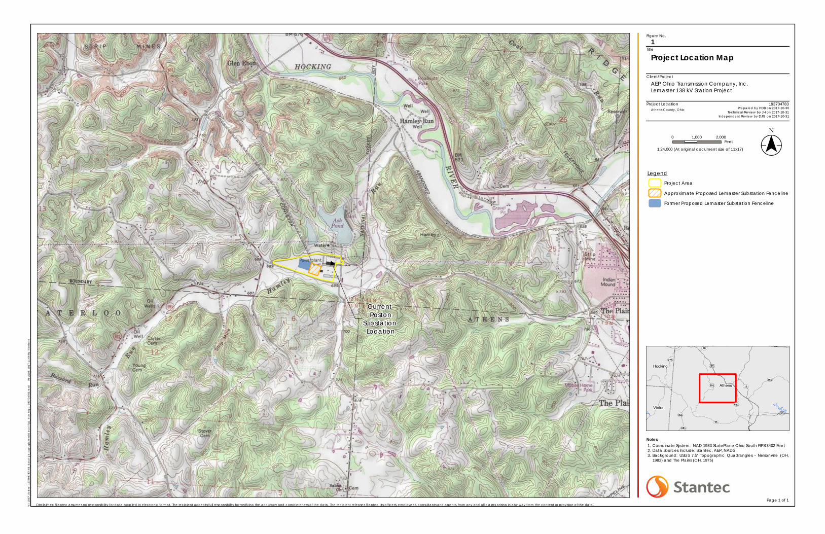
Project Location
Client/Project
Figure No.
Title
ST356
ST78
ST56
ST682
ST681
ST550
ST691
ST278
ST13
£¤50
£¤33
Athens
Hocking
Vinton
Current Poston
Substation Location
Project Location Map1
AEP Ohio Transmission Company, Inc.Lemaster 138 kV Station Project
Notes1.2.3.
0 1,000 2,000Feet
V:\
1937
\Ac
tive
\193
7047
83\0
3_d
ata
\g
is_c
ad
\gis\
mxd
s\e
co\f
ig1_
eco
_to
po
_193
7047
83.m
xd
Re
vise
d: 2
017-
11-0
6 By
: hb
ello
ne
($$¯1:24,000 (At original document size of 11x17)
193704783
Disclaimer: Stantec assumes no responsibility for data supplied in electronic format. The recipient accepts full responsibility for verifying the accuracy and completeness of the data. The recipient releases Stantec, its officers, employees, consultants and agents, from any and all claims arising in any way from the content or provision of the data.Page 1 of 1
Athens County, Ohio Prepared by HDB on 2017-10-30Technical Review by JH on 2017-10-31
Independent Review by DJG on 2017-10-31
Legend
Project Area
Approximate Proposed Lemaster Substation Fenceline
Former Proposed Lemaster Substation Fenceline
Coordinate System: NAD 1983 StatePlane Ohio South FIPS 3402 FeetData Sources Include: Stantec, AEP, NADSBackground: USGS 7.5' Topographic Quadrangles - Nelsonville (OH,1983) and The Plains (OH, 1975)

LEMASTER 138 KV STATION PROJECT, ATHENS COUNTY, OHIO
A.2
A.2 FIGURE 2 – WETLAND AND WATERBODY DELINEATION MAP
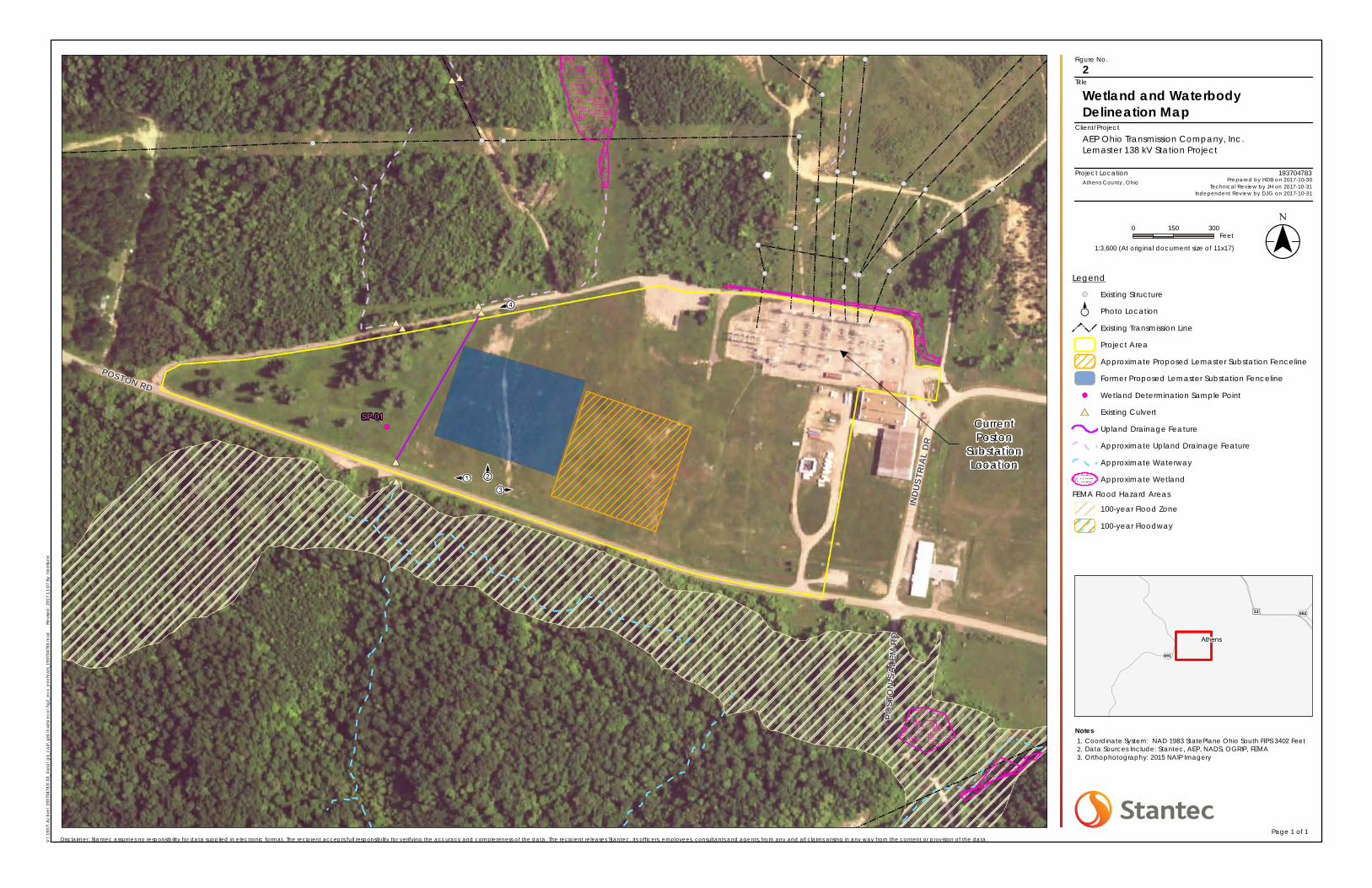
Project Location
Client/Project
Figure No.
Title
ST691
ST682£¤33
Athens
#*
#*
#*
#*#*
#*#*
#*#*
!(
E
· .
E
·.
E
·.E ·.
!(
!(
!(
!(
!(
!(
!(
!(
!(
!(
!(
!(
!(
!(
!(
!(
!(!(!(
!(
!(
!(
SP-01
POST
ON-S
ALEM
RD
INDU
STRI
AL D
R
POSTON RD
1 2
3
4
Wetland and WaterbodyDelineation Map
2
AEP Ohio Transmission Company, Inc.Lemaster 138 kV Station Project
Notes1.2.3.
0 150 300Feet
V:\
1937
\Ac
tive
\193
7047
83\0
3_d
ata
\g
is_c
ad
\gis\
mxd
s\e
co\f
ig2_
eco
_env
fea
ts_1
9370
4783
.mxd
Revi
sed
: 201
7-11
-07
By: h
bel
lone
($$¯1:3,600 (At original document size of 11x17)
193704783
Disclaimer: Stantec assumes no responsibility for data supplied in electronic format. The recipient accepts full responsibility for verifying the accuracy and completeness of the data. The recipient releases Stantec, its officers, employees, consultants and agents, from any and all claims arising in any way from the content or provision of the data.Page 1 of 1
Athens County, Ohio Prepared by HDB on 2017-10-30Technical Review by JH on 2017-10-31
Independent Review by DJG on 2017-10-31
Legend
!( Existing StructureE
·. Photo Location
Existing Transmission Line
Project Area
Approximate Proposed Lemaster Substation Fenceline
Former Proposed Lemaster Substation Fenceline
!( Wetland Determination Sample Point
#* Existing Culvert
Upland Drainage Feature
Approximate Upland Drainage Feature
Approximate Waterway
Approximate Wetland
FEMA Flood Hazard Areas
100-year Flood Zone
100-year Floodway
Coordinate System: NAD 1983 StatePlane Ohio South FIPS 3402 FeetData Sources Include: Stantec, AEP, NADS, OGRIP, FEMAOrthophotography: 2015 NAIP Imagery
CurrentPoston
SubstationLocation

LEMASTER 138 KV STATION PROJECT, ATHENS COUNTY, OHIO
A.3
A.3 FIGURE 3 – HABITAT ASSESSMENT MAP
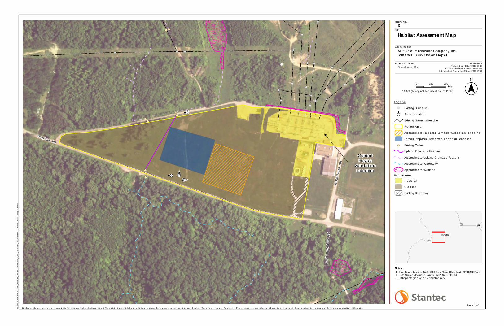
Project Location
Client/Project
Figure No.
Title
ST691
ST682£¤33
Athens
#*
#*
#*
#*#*
#*#*
#*#*
E
· .
E
·.
E
·.E ·.
!(
!(
!(
!(
!(
!(
!(
!(
!(
!(
!(
!(
!(
!(
!(
!(
!(!(!(
!(
!(
!(
POST
ON-S
ALEM
RD
INDU
STRI
AL D
R
POSTON RD
1 2
3
4
Habitat Assessment Map3
AEP Ohio Transmission Company, Inc.Lemaster 138 kV Station Project
Notes1.2.3.
0 150 300Feet
V:\
1937
\Ac
tive
\193
7047
83\0
3_d
ata
\g
is_c
ad
\gis\
mxd
s\e
co\f
ig3_
eco
_ha
ba
rea
s_19
3704
783.
mxd
Revi
sed
: 201
7-11
-07
By: h
be
llone
($$¯1:3,600 (At original document size of 11x17)
193704783
Disclaimer: Stantec assumes no responsibility for data supplied in electronic format. The recipient accepts full responsibility for verifying the accuracy and completeness of the data. The recipient releases Stantec, its officers, employees, consultants and agents, from any and all claims arising in any way from the content or provision of the data.Page 1 of 1
Athens County, Ohio Prepared by HDB on 2017-10-30Technical Review by JH on 2017-10-31
Independent Review by DJG on 2017-10-31
Legend
!( Existing StructureE
·. Photo Location
Existing Transmission Line
Project Area
Approximate Proposed Lemaster Substation Fenceline
Former Proposed Lemaster Substation Fenceline
#* Existing Culvert
Upland Drainage Feature
Approximate Upland Drainage Feature
Approximate Waterway
Approximate Wetland
Habitat Area
Industrial
Old Field
Existing Roadway
Coordinate System: NAD 1983 StatePlane Ohio South FIPS 3402 FeetData Sources Include: Stantec, AEP, NADS, OGRIPOrthophotography: 2015 NAIP Imagery
CurrentPoston
SubstationLocation

LEMASTER 138 KV STATION PROJECT, ATHENS COUNTY, OHIO
B.1
Agency Correspondence

Office of Real Estate
Paul R. Baldridge, Chief
2045 Morse Road – Bldg. E-2 Columbus, OH 43229
Phone: (614) 265-6649
Fax: (614) 267-4764
December 30, 2016
Dan Godec Stantec Consulting Services Inc. 11687 Lebanon Road Cincinnati, Ohio 45241
Re: 16-865; Request for Technical Assistance, AEP Lemaster Station Project
Project: The proposed project involves the construction of the Lemaster Station.
Location: The proposed project is located in York, Dover, and Waterloo Townships, Athens County, Ohio. The Ohio Department of Natural Resources (ODNR) has completed a review of the above referenced project. These comments were generated by an inter-disciplinary review within the Department. These comments have been prepared under the authority of the Fish and Wildlife Coordination Act (48 Stat. 401, as amended; 16 U.S.C. 661 et seq.), the National Environmental Policy Act, the Coastal Zone Management Act, Ohio Revised Code and other applicable laws and regulations. These comments are also based on ODNR’s experience as the state natural resource management agency and do not supersede or replace the regulatory authority of any local, state or federal agency nor relieve the applicant of the obligation to comply with any local, state or federal laws or regulations.
Natural Heritage Database: The Natural Heritage data request response is included on pages 3-4 of the project documentation. Fish and Wildlife: The Division of Wildlife (DOW) has the following comments. The DOW recommends that impacts to streams, wetlands and other water resources be avoided and minimized to the fullest extent possible, and that best management practices be utilized to minimize erosion and sedimentation. The project is within the vicinity of records for the Indiana bat (Myotis sodalis), a state
endangered and federally endangered species. Presence of the Indiana bat has been
established in the area, and therefore additional summer surveys would not constitute
presence/absence in the area. The following species of trees have relatively high value as potential Indiana bat roost trees: shagbark hickory (Carya ovata), shellbark hickory (Carya
laciniosa), bitternut hickory (Carya cordiformis), black ash (Fraxinus nigra), green ash (Fraxinus
pennsylvanica), white ash (Fraxinus americana), shingle oak (Quercus imbricaria), northern red oak (Quercus rubra), slippery elm (Ulmus rubra), American elm (Ulmus americana), eastern cottonwood (Populus deltoides), silver maple (Acer saccharinum), sassafras (Sassafras albidum), post oak (Quercus stellata), and white oak (Quercus alba). Indiana bat roost trees consists of
trees that include dead and dying trees with exfoliating bark, crevices, or cavities in upland areas or riparian corridors and living trees with exfoliating bark, cavities, or hollow areas formed from broken branches or tops. However, Indiana bats are also dependent on the forest structure surrounding roost trees. If suitable habitat occurs within the project area, the DOW recommends trees be conserved. If suitable habitat occurs within the project area and trees must be cut, the DOW recommends cutting occur between October 1 and March 31. If no tree removal is proposed, this project is not likely to impact this species. The project is within the range of the club shell (Pleurobema clava), a state endangered and federally endangered mussel, the sheepnose (Plethobasus cyphyus), a state endangered and federally endangered mussel, the fanshell (Cyprogenia stegaria), a state endangered and federally endangered mussel, the pink mucket (Lampsilis orbiculata), a state endangered and federally endangered mussel, the snuffbox (Epioblasma triquetra), a state endangered and federally endangered mussel, the threehorn wartyback (Obliquaria reflexa), a state threatened mussel, the fawnsfoot (Truncilla donaciformis), a state threatened mussel, and the black sandshell (Ligumia
recta), a state threatened mussel. Due to the location, and that there is no in-water work proposed in a perennial stream of sufficient size, this project is not likely to impact these species. The project is within the range of the channel darter (Percina copelandi), a state threatened fish, and the river darter (Percina shumardi), a state threatened fish. The DOW recommends no in-water work in perennial streams from April 15 to June 30 to reduce impacts to indigenous aquatic species and their habitat. If no in-water work is proposed, this project is not likely to impact these or other aquatic species. The project is within the range of the timber rattlesnake (Crotalus horridus horridus), a state endangered species, and a federal species of concern. The timber rattlesnake is a woodland species. In addition to using wooded areas, the timber rattlesnake also utilizes sunlit gaps in the canopy for basking and deep rock crevices known as den sites for overwintering. Due to the location, the type of habitat at the project site, and the type of work proposed, this project is not likely to impact this species. The project is within the range of the eastern spadefoot toad (Scaphiopus holbrookii), a state endangered species. This species is found in areas of sandy soils that are associated with river valleys. Breeding habitats may include flooded agricultural fields or other water holding depressions. Due to the location, the type of habitat at the project site and within the vicinity of the project area, and the type of work proposed, this project is not likely to impact this species. The project is within the range of the mud salamander (Pseudotriton montanus), a state threatened species. Due to the location, the type of habitat present at the project site, and the type of work proposed, this project is not likely to impact this species. The project is within the range of the black bear (Ursus americanus), a state endangered species. Due to the mobility of this species, this project is not likely to impact this species. Due to the potential of impacts to federally listed species, as well as to state listed species, we recommend that this project be coordinated with the U.S. Fish & Wildlife Service. Water Resources: The Division of Water Resources has the following comment. The local floodplain administrator should be contacted concerning the possible need for any floodplain permits or approvals for this project. Your local floodplain administrator contact information can be found at the website below.

http://water.ohiodnr.gov/water-use-planning/floodplain-management#PUB ODNR appreciates the opportunity to provide these comments. Please contact John Kessler at (614) 265-6621 if you have questions about these comments or need additional information. John Kessler ODNR Office of Real Estate 2045 Morse Road, Building E-2 Columbus, Ohio 43229-6693 [email protected]
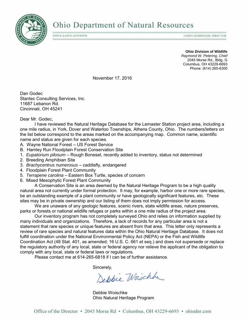
Ohio Division of Wildlife Raymond W. Petering, Chief
2045 Morse Rd., Bldg. G Columbus, OH 43229-6693
Phone: (614) 265-6300 November 17, 2016 Dan Godec Stantec Consulting Services, Inc. 11687 Lebanon Rd. Cincinnati, OH 45241 Dear Mr. Godec,
I have reviewed the Natural Heritage Database for the Lemaster Station project area, including a one mile radius, in York, Dover and Waterloo Townships, Athens County, Ohio. The numbers/letters on the list below correspond to the areas marked on the accompanying map. Common name, scientific name and status are given for each species. A. Wayne National Forest – US Forest Service B. Hamley Run Floodplain Forest Conservation Site 1. Eupatorium pilosum – Rough Boneset, recently added to inventory, status not determined 2. Breeding Amphibian Site 3. Brachycentrus numerosus – caddisfly, endangered 4. Floodplain Forest Plant Community 5. Terrapene carolina – Eastern Box Turtle, species of concern 6. Mixed Mesophytic Forest Plant Community A Conservation Site is an area deemed by the Natural Heritage Program to be a high quality natural area not currently under formal protection. It may, for example, harbor one or more rare species, be an outstanding example of a plant community or have geologically significant features, etc. These sites may be in private ownership and our listing of them does not imply permission for access. We are unaware of any geologic features, scenic rivers, state wildlife areas, nature preserves, parks or forests or national wildlife refuges or parks within a one mile radius of the project area. Our inventory program has not completely surveyed Ohio and relies on information supplied by many individuals and organizations. Therefore, a lack of records for any particular area is not a statement that rare species or unique features are absent from that area. This letter only represents a review of rare species and natural features data within the Ohio Natural Heritage Database. It does not fulfill coordination under the National Environmental Policy Act (NEPA) or the Fish and Wildlife Coordination Act (48 Stat. 401, as amended; 16 U.S. C. 661 et seq.) and does not supersede or replace the regulatory authority of any local, state or federal agency nor relieve the applicant of the obligation to comply with any local, state or federal laws or regulations.
Please contact me at 614-265-6818 if I can be of further assistance. Sincerely,
Debbie Woischke Ohio Natural Heritage Program
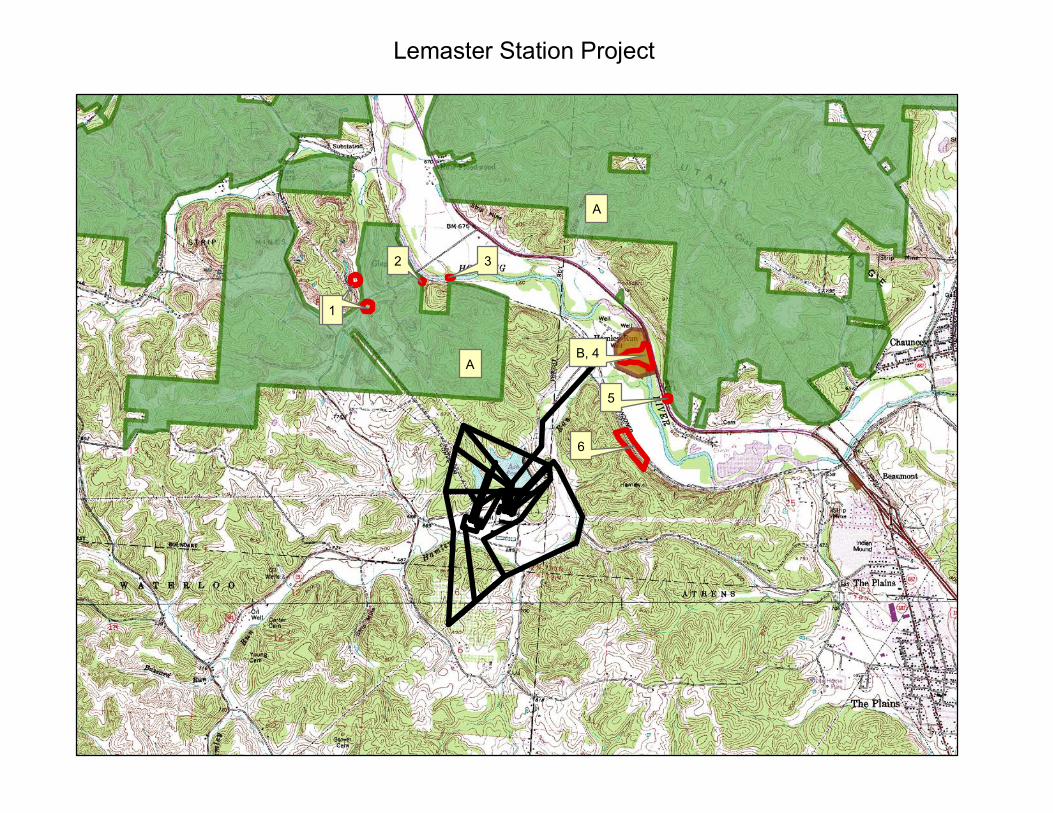
Lemaster Station Project
11
2 3
B, 4
5
6
A
A


LEMASTER 138 KV STATION PROJECT, ATHENS COUNTY, OHIO
C.1
Representative Photographs
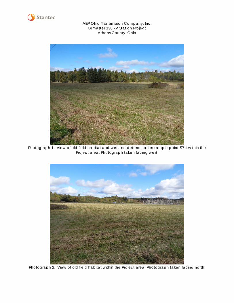
AEP Ohio Transmission Company, Inc.
Lemaster 138 kV Station Project Athens County, Ohio
Photograph 1. View of old field habitat and wetland determination sample point SP-1 within the
Project area. Photograph taken facing west.
Photograph 2. View of old field habitat within the Project area. Photograph taken facing north.
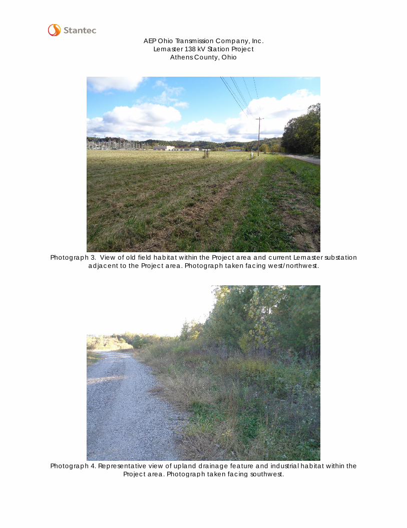
AEP Ohio Transmission Company, Inc.
Lemaster 138 kV Station Project Athens County, Ohio
Photograph 3. View of old field habitat within the Project area and current Lemaster substation
adjacent to the Project area. Photograph taken facing west/northwest.
Photograph 4. Representative view of upland drainage feature and industrial habitat within the
Project area. Photograph taken facing southwest.

LEMASTER 138 KV STATION PROJECT, ATHENS COUNTY, OHIO
D.1
Data Forms
D.1 WETLAND DETERMINATION DATA FORMS

Page 1 of 2
Project/Site: Stantec Project #: 193704783 Date: Applicant: County: Investigator #1: Investigator #2: State: Soil Unit: Wetland ID: Landform: Sample Point: Slope (%): 0% Latitude: 39.38179 Longitude: Datum: NAD83 Community ID: Are climatic/hydrologic conditions on the site typical for this time of year? (If no, explain in remarks) Section: 1 Are Vegetation , Soil , or Hydrology significantly disturbed? Township: 12N Are Vegetation , Soil , or Hydrology naturally problematic? Range: 15W Dir: --SUMMARY OF FINDINGS Hydrophytic Vegetation Present? Yes No Hydric Soils Present? Yes No Wetland Hydrology Present? Yes No Is This Sampling Point Within A Wetland? Yes No
HYDROLOGY Wetland Hydrology Indicators (Check here if indicators are not present ): Secondary:
Primary: B6 - Surface Soil CracksA1 - Surface Water B9 - Water-Stained Leaves B8 - Sparsely Vegetated Concave SurfaceA2 - High Water Table B13 - Aquatic Fauna B10 - Drainage PatternsA3 - Saturation B14 - True Aquatic Plants B16 - Moss Trim LinesB1 - Water Marks C1 - Hydrogen Sulfide Odor C2 - Dry Season Water TableB2 - Sediment Deposits C3 - Oxidized Rhizospheres on Living Roots C8 - Crayfish BurrowsB3 - Drift Deposits C4 - Presence of Reduced Iron C9 - Saturation Visible on Aerial ImageryB4 - Algal Mat or Crust C6 - Recent Iron Reduction in Tilled Soils D1 - Stunted or Stressed PlantsB5 - Iron Deposits C7 - Thin Muck Surface D2 - Geomorphic PositionB7 - Inundation Visible on Aerial Imagery Other (Explain in Remarks) D3 - Shallow Aquitard
D4 - Microtopographic ReliefD5 - FAC-Neutral Test
Field Observations: Surface Water Present? Yes No Depth: (in.) Water Table Present? Yes No Depth: (in.) Saturation Present? Yes No Depth: (in.)
SOILS Map Unit Name: FcA - Fitchville silt loam, 0-3% slopes Series Drainage Class: Taxonomy (Subgroup):
Top BottomDepth Depth Horizon % % Type Location
0 16 -- 10YR 4/4 100 -- -- -- -- ---- -- -- -- -- -- -- -- -- -- ---- -- -- -- -- -- -- -- -- -- ---- -- -- -- -- -- -- -- -- -- ---- -- -- -- -- -- -- -- -- -- ---- -- -- -- -- -- -- -- -- -- ---- -- -- -- -- -- -- -- -- -- ---- -- -- -- -- -- -- -- -- -- --
NRCS Hydric Soil Field Indicators (check here if indicators are not present ): Indicators for Problematic Soils 1
A1- Histosol S5 - Sandy Redox F12 - Iron-Manganese Masses (LRR N, MLRA 136) A10 - 2cm Muck (MLRA 147)
A2 - Histic Epipedon S6 - Stripped Matrix F13 - Umbric Surface (MLRA 122, 136) A16 - Coast Prairie Redox (MLRA 147, 148)
A3 - Black Histic S7 - Dark Surface F19 - Piedmont Floodplain Soils (MLRA 148) F19 - Piedmont Floodplain Soils (MLRA 136, 147)
A4 - Hydrogen Sulfide S8 - Polyvalue Below Dark Surface (MLRA 147, 148) TF12 - Very Shallow Dark Surface A5 - Stratified Layers S9 - Thin Dark Surface (MLRA 147, 148) F21 - Red Parent Material (MLRA 127, 147) Other (Explain in Remarks) A10 - 2 cm Muck (LRR N) F2 - Loamy Gleyed Matrix A11 - Depleted Below Dark Surface F3 - Depleted Matirx A12 - Thick Dark Surface F6 - Redox Dark Surface S1 - Sandy Muck Mineral (LRR N, MLRA 147, 148) F7 - Depleted Dark Surface S4 - Sandy Gleyed Matrix F8 - Redox Depressions 1 Indicators of hydrophytic vegetation and wetland hydrology must be present, unless disturbed or problematic.
WETLAND DETERMINATION DATA FORMEastern Mountains and Piedmont Region
Yes NoAre normal circumstances present?
Yes No
Wetland Hydrology Present? Yes No
11/07/16
PFOFcA - Fitchville silt loam, 0-3% slopes NWI/WWI Classification:
Describe Recorded Data (stream gauge, monitoring well, aerial photos, previous inspections), if available:
silt loamColor (Moist)
Restrictive Layer (If Observed)
Remarks:
Type: N/A Depth: N/A Hydric Soil Present?
Profile Description (Describe to the depth needed to document the indicator or confirm the absence of indicators.) (Type: C=Concentration, D=Depletion, RM=Reduced Matrix, CS=Covered/Coated Sand Grains; Location: PL=Pore Lining, M=Matrix)
Lemaster 138 kV Station Project American Electric Power Aaron Kwolek
----
Remarks:
--
----
No
Fill material
Texture(e.g. clay, sand, loam)
Yes
Matrix
somewhat poorly drained
N/A
Dip Local Relief: Concave-82.184290
--
Color (Moist)Mottles
UPL
--
Remarks:
Jody NicolsonAthensOhioNASP-1
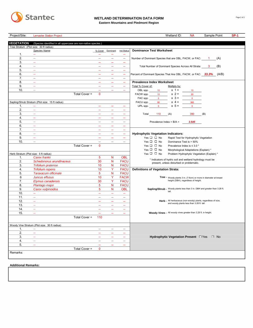
Page 2 of 2
Project/Site: NA SP-1
VEGETATION (Species identified in all uppercase are non-native species.) Tree Stratum (Plot size: 30 ft radius)
% Cover Dominant Ind.Status Dominance Test Worksheet1. -- -- --2. -- -- -- (A)3. -- -- --4. -- -- -- (B)5. -- -- --6. -- -- -- (A/B)7. -- -- --8. -- -- -- Prevalence Index Worksheet9. -- -- --10. -- -- -- OBL spp. 10 x 1 = 10
0 FACW spp. 10 x 2 = 20
FAC spp. 0 x 3 = 0
FACU spp. 90 x 4 = 360
1. -- -- -- UPL spp. 0 x 5 = 0
2. -- -- --3. -- -- -- Total 110 (A) 390 (B)4. -- -- --5. -- -- -- Prevalence Index = B/A = 3.545
6. -- -- --7. -- -- --8. -- -- -- Hydrophytic Vegetation Indicators:9. -- -- -- Yes No Rapid Test for Hydrophytic Vegetation10. -- -- -- Yes No Dominance Test is > 50%
0 Yes No Prevalence Index is ≤ 3.0 *Yes No Morphological Adaptations (Explain) *Yes No Problem Hydrophytic Vegetation (Explain) *
1. 5 N OBL2. 30 N FACU3. 10 N FACU4. 10 Y FACU5. 5 N FACU6 10 Y FACW7. 30 Y FACU8. 5 N FACU9. 5 N OBL Sapling/Shrub -10. -- -- --11. -- -- --12. -- -- --13. -- -- --14. -- -- --15. -- -- --
110
1. -- -- --2. -- -- --3. -- -- -- Hydrophytic Vegetation Present Yes No4. -- -- --5. -- -- --
0
Additional Remarks:
* Indicators of hydric soil and wetland hydrology must be present, unless disturbed or problematic.
Woody Vine Stratum (Plot size: 30 ft radius)
Total Cover =
--
--
Carex vulpinoidea
--
Woody plants 3 in. (7.6cm) or more in diameter at breast height (DBH), regardless of height.
Woody plants less than 3 in. DBH and greater than 3.28 ft. tall.
Total Cover =
Eastern Mountains and Piedmont RegionWETLAND DETERMINATION DATA FORM
Taraxacum officinale
1
3
Species Name
Total Number of Dominant Species Across All Strata:
Number of Dominant Species that are OBL, FACW, or FAC:
Percent of Dominant Species That Are OBL, FACW, or FAC:
Elymus canadensis
--
Juncus effusus
Total Cover =
--
--
--
--
Total Cover =
Trifolium pratense
Trifolium repens
--
Sapling/Shrub Stratum (Plot size: 15 ft radius)
--
Carex frankii
--
--
--
--
33.3%
--
--
--
Schedonorus arundinaceus
Tree -
Wetland ID:
Definitions of Vegetation Strata:
Plantago major
Herb -
Herb Stratum (Plot size: 5 ft radius)
--
All herbaceous (non-woody) plants, regardless of size, and woody plants less than 3.28 ft. tall.
Multiply by:
Remarks:
Sample PointLemaster Station Project
--
--
--
--
--
Total % Cover of:
--
--
--
--
--
--
--
Woody Vines - All woody vines greater than 3.28 ft. in height.
--