level and trend of urbanization: a study on purulia .... 22 issue12/version-3... · level and trend...
TRANSCRIPT

IOSR Journal Of Humanities And Social Science (IOSR-JHSS)
Volume 22, Issue 12, Ver. 3 (December. 2017) PP 10-20
e-ISSN: 2279-0837, p-ISSN: 2279-0845.
www.iosrjournals.org
DOI: 10.9790/0837-2212031020 www.iosrjournals.org 10 | Page
Level and Trend of Urbanization: A Study on Purulia District of
West Bengal
Santanu Mandal Department of Geography, Bankura Zilla Saradamani Mahila Mahavidyapith, West Bengal, India
Abstract: In world scenario almost half of the population lives in urban area. But India and other developing
countries was going on below the world average. The present study analyzes the level and trend of urbanization
of Purulia district in West Bengal. This study was based on the secondary data and it was a block level study.
Level and trend of urbanization process was studied by different indices, those are- levels of urbanization or
degree of urbanization, decadal growth rate of urbanization, rate of urbanization, pace of urbanization, rank size
rule etc. and lastly analyzed the correlation among different variables which was related to urbanization by
Pearson’s product moment correlation coefficient. The result of the study explores that the level of urbanization
was very low at the study area. Urbanization level of only two to three blocks is good and some blocks are
growing negatively. Where crude literacy rate was high there was more concentrate of urban population in
context of this district. Rate and level of urbanization was negative relation with primary worker and sex ratio.
Key Word: Pace of Urbanization, Rate of Urbanization, Urban Density, Urbanization.
----------------------------------------------------------------------------------------------------------------------------- ----------
Date of Submission: 25-11-2017 Date of acceptance: 09-12-2017
----------------------------------------------------------------------------------------------------------------------------- ---------
I. INTRODUCTION Urbanization means the forward of our society to development. In the urbanization process a
progressive change of people (social, physiological and behavioral) and their activity in town or city, also
changes of structural characteristic of population are occurred. Urbanization is not about the population size, but
must satisfy certain conditions like modernization, physical and economic development, as well as the
heterogeneity in occupation [1], [2]. Lampard suggests that a distinction should be made between the three
aspects of the process of urbanization, i.e., behavioral, structural and demographic aspects of urbanization
process [3]. In the process of urbanization most of the people shift his work from primary to secondary or
tertiary and improve the standard of leaving, higher life expectancy, education etc. Urbanization is associated
with greater access to employment opportunities, lower fertility levels and increased independence.
Purulia district is very low populated than the other districts of West Bengal. Percentage of urban
population is very low in Purulia (12.75%) than the average rate of India (31.16%) and West Bengal (31.89%)
[4]. Here growth rate of urban area in numbers was little much slower than the average rate of West Bengal. It is
142% in West Bengal and 133% in Purulia. Average decadal Growth rate to total urban population was very
slower up to 1951(19.20%) after this period this rate was increased very high up to 2001(45.1%) and last
decade this rate was 46.15% (census of India 2011). Growth rate of urban population to total population from
2001-2011 was 2.86%. At present 19 towns are class-V, 4 in class-IV, and 3 in class-III. Only Purulia town,
Santaldihi Thermal Power Project Plant town are Class-I and class-VI of the town in the district. Sixteen new
census towns were added in census 2011. Percentage of urban population to the total population of the entire
block was below the national level and state level average. Urban populations of some blocks are zero and
some blocks are under 5%. Urban population of Raghunathpur (18.08%), Para (16.26%) and Balarampur
(17.71%) blocks were above 15% (census of India 2011).
II. STUDY AREA The selected study area is Purulia district of West Bengal and it is the western most district of west
Bengal. This district is the part of the Chotanagpur plateau region and it is the draught prone area of West
Bengal. North, south and western part of the district are surrounded by Jharkhand state and eastern part is
surrounding by Bankura, Burdwan West and Jhargram district. Latitudinal extension of the region is 85° 43’E to
86° 55’E and latitudinal extension is 22° 38’N to 23° 37’ N.

Level and Trend of Urbanization: A Study on Purulia District of West Bengal
DOI: 10.9790/0837-2212031020 www.iosrjournals.org 11 | Page
III. OBJECTIVES Main objectives of the study are-
I. Explore the level and trend of urbanization.
II. To study the growth of the city.
III. Analysis the transformation of the city in different census year.
IV. To study the rank size rule of the city.
V. Examine the correlation with different variables of urbanization.
IV. METHODOLOGY This study was mainly based on the secondary data and it was a block level study. Data sources are primarily
Census of India 2001 and 2011. Level, growth and rate of urbanization was calculated according to
Sivaramakrishnan et al., (2005), [5] and there are-
A. Level of urbanization= (Urban Population/Total Population) X 100
B. Decadal growth of urban population (2001-2011) = {Urban Population (2011) ─ Urban Population
(2001)} / Urban Population (2001) X 100
C. Rate of Urbanization (2001-2011) = (Per cent of Urban Population in 2011─ Per cent of Urban
Population in 2001) C Per cent of Urban Population in 2001 X 100
Urban density was calculated by the following way-
Urban Density = Urban Population / Area
Pace of urbanization was calculated by using Eldridge index (Vaidyanathan, 1981) [6]. The formula
was –
Pace of Urbanization (2001-2011) = [(Percentage of Urban Population in 2011 ─ Percentage Urban
Population in 2001) / (100 ─ Urban Population in 2001)] X 100
We calculate the Zipf’s Rank size Rule of the town of the study area (Saha and Basu) [7]. The formula
was
𝑃𝑖 =𝐾
𝑟𝑖
Where, Pi= expected population of a town of rank, ri = rank of the city in descending order, K= population of the largest
town.
Lastly we calculate the Pearson’s product moment correlation co-efficient of different variables.
V. LITERATURE REVIEW Here we attempt to study some literature which relevant to the present study. Many of the researchers
discuss the present condition of urbanization of India and West Bengal. Ramachandan [8], Chand & Puri [9],
and Roy Chaudhuri [10] et.al. presented an in depth discussion about India’s urbanization. A. Sarkar focused on
West Bengal’s (W.B.) urbanization and it’s city size distribution, where he noticed that in W.B.’s urban scene
larger cities grew very fast whereas small and medium towns have consistently declined in size in the period
1901 to 2001 [11]. In West Bengal rates of upgradation to big town was very low. S. Chatterjee stated that the
period of 2001 and 2011 only three new cities (Class I towns) have grown that signifies very low graduation of
lower order towns into higher order [12]. Aktar and Sultana examined that the degree of urbanization is very
low in Purulia district. Growth rate and pace of urbanization is negative in some block [13]. Difference of
population of largest city and next city is very high.
VI. RESULT AND DISCUSSION 1. Trend of Urbanization and Transformation of city’s Class-
In Fig no.-1 it was clearly seen that the growth of urban population of the district was very slower in all
the census years. The share of percentage of urban population to total population of West Bengal was greater
than Indian average and Purulia has too low than the national and state average. From the period of 1961 to
2001 share of urban population to the total population was very low in the district. In 2011 census it was found
little much higher than the previous census but it was almost half of the State and National average.

Level and Trend of Urbanization: A Study on Purulia District of West Bengal
DOI: 10.9790/0837-2212031020 www.iosrjournals.org 12 | Page
Fig-1 Source: District Census Handbook, Purulia, 2011[4],
Computed and calculated by author
In the census year 1971 total seven urban areas were located in the district. That time Purulia have class
–II town and it was continue up to 1991 census. In the census 1981 only Santaldihi Thermal Power Project town
added as a class-V town. Adra town upgraded from class-IV to class-III town and it was continue up to 2011
census. Nabagram and Hijuli were added as a census town in 1991 census and all other town maintain their
same class except Santaldihi Thermal Power Project town. This town was fall down to class-VI town and it was
maintain up to census 2011. Par Beliya, Barabazar was added as new census town in 2001. In this year Purulia
upgraded to class-I and Balarampur class-III. It was maintained up to 2011 census. In the last census the highest
number of town added and the number was 16 and total 28 urban bodies found. In the census one class-I, three
class-III, four class- IV, nineteen class- V and one class-VI town are found.
Table-1 Change of class of towns (1971-2011)
Class
of
Town
1971 1981 1991 2001 2011
NO. Name NO Name NO Name NO Name NO Name
I 1 Purulia 1 Purulia
II 1 Purulia 1 Purulia 1 Purulia
III 1 Adra 1 Adra 3 Adra,
Balaram
pur,
Raghuna
thpur
3 Adra, Balarampur,
Raghunathpur
IV 5 Arra,
Adra,
Balara
mpur,
Jhalda,
Raghun
athpur
4 Arra,
Balarampu
r, Jhalda,
Raghunath
pur
4 Arra,
Balara
mpur,
Jhalda,
Raghun
athpur
2 Arra,
Jhalda
4 Jaipur, Shankara,
Arra, Jhalda
V 1 Chapri, 2 Chapri,
Santaldihi
Thermal
Power
Project
town
3 Chapri,
Nabagr
am,
Hijuli
5 Chapri,
Nabagra
m,
Hijuli,
Par
Beliya,
Barabaz
ar
19 Raghabpur,
Hutmura, Kanki,
Dubra, Chapri,
Nabagram, Saltor,
Hijuli, Par Beliya,
Murulia,
Kantaranguri,
Lapara, Lagda,
Jhalda(p), Cherkya,
Begun Kodar,
Barabazar,
0
5
10
15
20
25
30
35
1961 1971 1981 1991 2001 2011
Purulia
West
Bengal
India
% o
f U
rban
Po
pula
tio
n
Census Year
Percentage of Urban Population in Diffrent Census

Level and Trend of Urbanization: A Study on Purulia District of West Bengal
DOI: 10.9790/0837-2212031020 www.iosrjournals.org 13 | Page
Manbazar, Bandoan
VI 1 Santald
ihi
Therma
l Power
Project
town
1 Santaldi
hi
Thermal
Power
Project
town
1 Santaldihi Thermal
Power Project town
Source: District Census Handbook, Purulia, 2001[14], 2011[4], computed and calculated by author
2. Level of Urbanization
In fig no.-2 we try to give a concept about level of urbanization by using choropleth method and
compare the percentage of urban population of 2001 and 2011 by bar diagram. Levels of urbanization of five
blocks are zero and they are Ashra, Bagmundi, Hura, Puncha, and Manbazar-II, where not an urban center has
been grown. Only two blocks are almost equal to the national and state average they are Purulia-II and
Raghunathpur-I. Bar diagram (fig. no.-2) clearly show that the Purulia-II and Raghunathpur-I has highest
concentrate of urban population. Many of the blocks newly set up their urban areas which are Jaipur, Jhalda-II,
Purulia-I, Manbazar-I, Bandoan, and Santuri in the last census 2011. One of the most important things is found,
there the urban populations of some blocks are decreasing and they are Raghunathpur-I & II and Balarampur.
Fig-2 Source: District Census Handbook, Purulia, 2001[14], 2011[4],
Computed and calculated by author
Level and Trend of Urbanization: A Study on Purulia District of West Bengal
DOI: 10.9790/0837-2212031020 www.iosrjournals.org 14 | Page
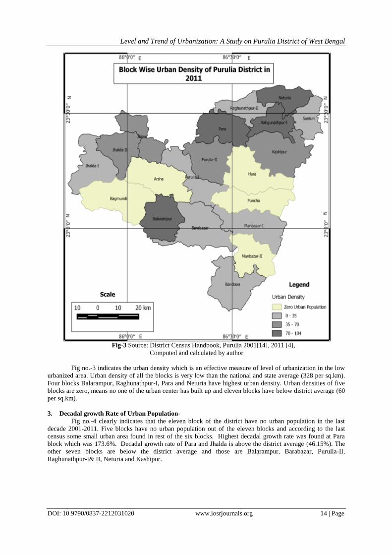
Fig-3 Source: District Census Handbook, Purulia 2001[14], 2011 [4],
Computed and calculated by author
Fig no.-3 indicates the urban density which is an effective measure of level of urbanization in the low
urbanized area. Urban density of all the blocks is very low than the national and state average (328 per sq.km).
Four blocks Balarampur, Raghunathpur-I, Para and Neturia have highest urban density. Urban densities of five
blocks are zero, means no one of the urban center has built up and eleven blocks have below district average (60
per sq.km).
3. Decadal growth Rate of Urban Population-
Fig no.-4 clearly indicates that the eleven block of the district have no urban population in the last
decade 2001-2011. Five blocks have no urban population out of the eleven blocks and according to the last
census some small urban area found in rest of the six blocks. Highest decadal growth rate was found at Para
block which was 173.6%. Decadal growth rate of Para and Jhalda is above the district average (46.15%). The
other seven blocks are below the district average and those are Balarampur, Barabazar, Purulia-II,
Raghunathpur-I& II, Neturia and Kashipur.

Level and Trend of Urbanization: A Study on Purulia District of West Bengal
DOI: 10.9790/0837-2212031020 www.iosrjournals.org 15 | Page
Fig-4 Source: District Census Handbook, Purulia 2001[14], 2011 [4],
Computed and calculated by author
4. Rate of Urbanization-
From the Fig. no- 5 it is clear that the rate of urbanization of Purulia district was very low than the
nation and state average in 1961 census. In 1971 rate of urbanization of the district was very high than the
national (10.80%) and state average (1.23%) because in this census year two census town (one class-IV and
another class-V) were added. Jhalda and Purulia town upgraded to class-III and class-II town respectively. After
this period this rate was continuously fall up to 2001 census. In the last census 2011 the highest rate was noticed
and it was 27.88% which were almost double to the state and national average. Although some towns are
growing negatively but after the addition of sixteen new census towns the overall growth rate of the district
increases.
Fig-5 Source: District Census Handbook, Purulia, 2011[4],
Computed and calculated by author
0
5
10
15
20
25
30
1961 1971 1981 1991 2001 2011
Purulia
West
Bengal
India
Rat
eo
f U
rban
izat
ion
Year
Rate of Urbanization in Diffrent Census

Level and Trend of Urbanization: A Study on Purulia District of West Bengal
DOI: 10.9790/0837-2212031020 www.iosrjournals.org 16 | Page
Fig-6 Source: District Census Handbook, Purulia 2001[14], 2011[4],
Computed and calculated by author
From the above fig no.-6 it was easily analyzed that the rate of urbanization of different blocks in the
last decade 2001 to 2011 was very poor but overall rate of urbanization was almost double than the national
(11.95) and state average (13.77). Five blocks has no urban population and rate of urbanization of six blocks is
zero because urban area of this block was added in the last census 2011. Some blocks show the negative rate of
urbanization, there are- Balarampur, Barabazar, Raghunathpur –I & II. Highest negative growth rate was found
in Raghunathpur-II (-12.61). The highest rate of urbanization found in Para block (138.14) and only two blocks
are above the national and state average.
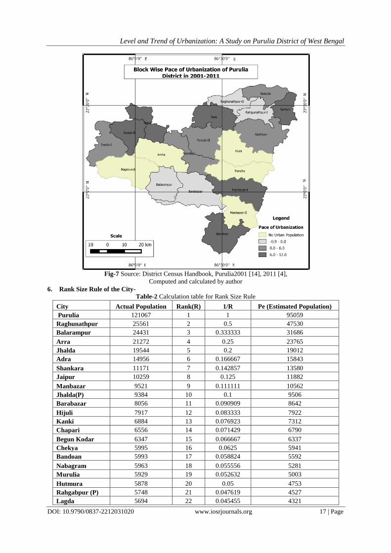
5. Pace of Urbanization-
It is clear in fig No.-7 that the pace of urbanization was very slow in the district. One interesting thing
is found that the Pace of urbanization of Balarampur, Barabazar, Raghunathpur –I & II block was negative. Four
blocks are below the national average. Only seven blocks were found above the national (4.67%) and state
average (5.67%) and highest Pace of urbanization was found in the Para block.
Level and Trend of Urbanization: A Study on Purulia District of West Bengal
DOI: 10.9790/0837-2212031020 www.iosrjournals.org 17 | Page
Fig-7 Source: District Census Handbook, Purulia2001 [14], 2011 [4],
Computed and calculated by author
6. Rank Size Rule of the City-
Table-2 Calculation table for Rank Size Rule
City Actual Population Rank(R) 1/R Pe (Estimated Population)
Purulia 121067 1 1 95059
Raghunathpur 25561 2 0.5 47530
Balarampur 24431 3 0.333333 31686
Arra 21272 4 0.25 23765
Jhalda 19544 5 0.2 19012
Adra 14956 6 0.166667 15843
Shankara 11171 7 0.142857 13580
Jaipur 10259 8 0.125 11882
Manbazar 9521 9 0.111111 10562
Jhalda(P) 9384 10 0.1 9506
Barabazar 8056 11 0.090909 8642
Hijuli 7917 12 0.083333 7922
Kanki 6884 13 0.076923 7312
Chapari 6556 14 0.071429 6790
Begun Kodar 6347 15 0.066667 6337
Chekya 5995 16 0.0625 5941
Bandoan 5993 17 0.058824 5592
Nabagram 5963 18 0.055556 5281
Murulia 5929 19 0.052632 5003
Hutmura 5878 20 0.05 4753
Rahgabpur (P) 5748 21 0.047619 4527
Lagda 5694 22 0.045455 4321

Level and Trend of Urbanization: A Study on Purulia District of West Bengal
DOI: 10.9790/0837-2212031020 www.iosrjournals.org 18 | Page
Dubra 5506 23 0.043478 4133
Kantaraguri 5435 24 0.041667 3961
Lapara 5367 25 0.04 3802
Par Beliya 5279 26 0.038462 3656
Saltor 5094 27 0.037037 3521
Santaldihi
Tharmal Power
Project Town 2507 28 0.035714 3395
373314 3.927171
Source: District Census Handbook, Purulia, 2011[4], computed and calculated by author
Fig-8 Source: District Census Handbook, Purulia, 2011[4],
Computed and calculated by author
From the table no- 2 and fig no- 8 it was examined that the population of the largest city was greater
than the estimated population. But the second and third ranked city’s population was very low than the
estimated population. Six, seven, eight and nine ranked city’s population was below than the estimated
population. Ten to twelve ranked town population almost same to the estimated population then up to 27th rank
town population is higher. Population of the 28th
rank town was lower than the estimated.
7. Relationship with different variable of urbanization-
Table-3 Pearson correlation co-efficient table Variables# LU DGRUP RU PU CLR PW SR UD
LU 1 .301 .201 .072 .559**
-.662**
-.482* .619
**
DGRUP .301 1 .985**
.461* .239 -.228 -.309 .576
**
RU .201 .985**
1 .532**
.160 -.166 -.243 .507*
PU .072 .461* .532
** 1 -.165 -.304 -.132 .283
CLR .559**
.239 .160 -.165 1 -.194 -.197 .241
PW -.662**
-.228 -.166 -.304 -.194 1 .649**
-.658**
SR -.482* -.309 -.243 -.132 -.197 .649
** 1 -.643
**
UD .619**
.576**
.507* .283 .241 -.658
** -.643
** 1
**. Correlation is significant at the 0.01 level (1-tailed).
*. Correlation is significant at the 0.05 level (1-tailed).
Source: District Census Handbook, Purulia, 2001 [14], 2011[4], computed and calculated by author
# Used variables in the study –
LU- Level of Urbanization, DGRUP- Decadal Growth Rate of Urban Population, RU –Rate of Urbanization,
PU- Pace of Urbanization, CLR- Crud Literacy Rate, PW- Primary Worker, SR- Sex Ratio, UD- Urban
Density.
0
20000
40000
60000
80000
100000
120000
140000
1 3 5 7 9 11 13 15 17 19 21 23 25 27
Actual Population
Pe(Estimated Population)

Level and Trend of Urbanization: A Study on Purulia District of West Bengal
DOI: 10.9790/0837-2212031020 www.iosrjournals.org 19 | Page
The table no.3 show the relationship with the different variables which is closely related with
urbanization. From the following evident we can easily understand that the level of urbanization was positive
relation with five variables, those are - decadal growth rate of urban population (DGRUP), rate of urbanization
(RU), pace of urbanization (PU), crud literacy rate (CLR), urban density (UD) and very strong with UD and
CLR. But two variables, primary worker (PW) and sex ratio (SR) are found strong negative relation. Relation
among the DGRUP, RU, PU, CLR and UD were positive. DGRUP was very strong positive relation with RU
and UD. Pace of urbanization with DGRUP and UD was positively related. Some variables PU, PW and SR are
negatively related with CLR in the district. Except SR all the variables are negatively related with percentage of
primary worker. A very strong positive relation was found in between LU and UD. All the variables are
negative relation with SR except PW. UD was strong positive relation amongst LU, DGRUP and RU.
VII. CONCLUSION After discussing all part of the paper it is clear that the level of urbanization of the district is very low.
Same thing examine by the Aktar and Sultana (2016) when they studied the degree of urbanization of West
Bengal [13]. After the analysis of urbanization trend and level in different census it was told that the shared of
urban population was very low but the rate of urbanizations was low up to 2001, after this census this rate
became very high than the average of national and state. Same was found by the Ghosh and Chakma (2014)
[15]. In the spatial analysis of urbanization it was found that the Para block was most forward block.
Urbanization process was mainly limited in the five or six blocks. One interesting thing explored in the study
that the rate of urbanization of some blocks (Raghunathpur-I & II, Balarampur, Barabazar) towns (Adra, Par
Baliya, Chapari, Santaldihi Thermal Power Project Town )are negatively grown where the rate of urbanization
was very high in the last census. The main causes of low rate of urbanization was most of the people depends on
agriculture and very low rate of industrialization. It was examined that only Purulia town has concentrate
32.43% of the total urban population. It was clearly seen that the people try to go toward the main city of the
district. From the study it is suggest that the government should take some steps for the development of small
urban area or town.
ACKNOWLEDGEMENT I would like to acknowledge Dr.Shovan Ghosh, associate professor of Department of Geography of Daimond
Harbour Women’s University for his kind help.
REFERENCE
[1]. L. Wirth, Urbanization as a way of Life, American Journal of Sociology, 44, January-1938, 1-24.
Retrieve from- https://www.jstor.org/stable/2768119?seq=1#page_scan_tab_contents 11/09/2017, 9:15
pm.
[2]. J. Harvey, Urban Land Economics, (Palgrave Macmillan, Fifth Edition, 2000), 256-257.
[3]. E.E. Lampard, Historical aspects of urbanization in P.M. Houser and L.E. Schnore, The Study of
Urbanization, (Newyork, 1965).
[4]. District Census Handbook, Purulia, West Bengal Series, (Census of India, 2011). Retrieve from-
http://www.censusindia.gov.in/2011census/dchb/DCHB.html, 11/09/2017, 8:22 pm.
[5]. K.C, Sivaramakrishnan, A. Kundu & B.N. Singh, Handbook of Urbanisation in India-An Analysis of
Trends and Processes, (Oxford University Press, 2005). 177
[6]. K.E. Vaidyanathan, Rural-Urban Distribution of Population in West Asia, (Population Geography, 3
(1&2), 1981) 96-113.
[7]. P. Saha, and P. Basu, Advanced Practical Geography, (Books & Allied (P) Ltd., 2010) 257-261.
[8]. R. Ramachandran, Urbanization and Urban System in India, (Oxford University Press, 1989).
[9]. M. Chan. and V.K. Puri, Regional Planning in India, (Allied Publishers Limited, 1982).
[10]. J.R. Roychaudhuri, An Introduction to Development and Regional Planning, (Orient Longman Ltd.
Kolkata, 2001).
[11]. A. Sarkar, Urbanization and City Size Distribution of West Bengal, India 1091-2001, Indian Journal of
Regional Science, 43(1),2001, 9-16.
[12]. S. Chakraborty, et al ,Changing Pattern of Urbanization in West Bengal: An Analysis of 2011 Census of
India Data, Asian Journal of Research in Social Sciences and Humanities, 5(5),2015, 169-181. Retrieve
fromhttp://www.researchgate.net/publication/279245898_Changing_Pattern_of_Urbanization_in_West_
Bengal_An_Analysis_of_2011_Census_of_India_Data, 11/09/2017, 8:30 pm.
[13]. N. Aktar & C. Sultana, Trends and Pattern of Urbanization in West Bengal, Pratidhwani the Echo,
V(I),2016,61-74. Retrieve from- https://www.thecho.in/files/Nasim-Akhtar-Chand-Sultana_dh43zf0t.pdf,
11/09/2017, 8:40 pm.

Level and Trend of Urbanization: A Study on Purulia District of West Bengal
DOI: 10.9790/0837-2212031020 www.iosrjournals.org 20 | Page
[14]. District Census Handbook, Purulia, West Bengal Series, (Census of India 2001).
[15]. B. Ghosh & N. Chakma, Urbanisation in West Bengal: An Analysis of Recent Processes, Space and
Culture,India,2(2),2014,29-41 Retrieve from-
http://www.spaceandculture.in/index.php/spaceandculture/article/view/86, 11/09/2017, 7:40 pm.
IOSR Journal Of Humanities And Social Science (IOSR-JHSS) is UGC approved Journal with
Sl. No. 5070, Journal no. 49323.
Santanu Mandal "Level and Trend of Urbanization: A Study on Purulia District of West
Bengal.” IOSR Journal Of Humanities And Social Science (IOSR-JHSS). vol. 22 no. 12, 2017,
pp. 10-20.