lewisian, torridonian and moine rocks of scotlandjncc.defra.gov.uk/pdf/v34chap1.pdf · lewisian,...
TRANSCRIPT

Chapter 1
Lewisian, Torridonian and Moine rocks
of Scotland: an introduction
From: Mendum, J.R., Barber, A.J., Butler, R.W.H., Flinn, D., Goodenough, K.M., Krabbendam, M., Park, R.G. and Stewart, A.D. (2008), Lewisian, Torridonian and Moine Rocks of Scotland, Geological Conservation Review Series, No. 34, Joint Nature Conservation Committee, Peterborough, 598 pages, illustrations, A4 hardback, ISBN 978 1 86107 566 6 For more information see: http://www.jncc.gov.uk/page-2746


Understanding tectonic processes
INTRODUCTION
M. Krabbendam, K.M. Goodenough andJ.R. Mendum
This volume describes the Precambrian rocks ofnorthern Scotland, including Archaean toPalaeoproterozoic basement (the LewisianGneiss Complex) and later Proterozoic sedi -mentary and metasedimentary rocks (theTorridonian and Moine successions). The volumealso contains detailed descriptions of structureswithin the Moine Thrust Belt and the northernpart of the Caledonian Orogen. The MoineThrust Belt is the orogenic front of the Silurian-age Scandian Event in the British Isles, andextends from Loch Eriboll on the north coast of Scotland to the Isle of Skye. The area coveredin this volume includes most of mainlandScotland north of the Great Glen, together withthe Outer Hebrides and parts of Shetland(Figure 1.1).
The Lewisian Gneiss Complex is exposed onthe Outer Hebrides and also along the north-west coast of the mainland. It is composed of avariety of gneisses, including the oldest rocks inthe British Isles, dated to just over 3000 Ma.Altogether, the Lewisian Gneiss Complex contains a record of igneous, depositional andorogenic events that occurred over a period of1400 million years – almost one-third of the history of the Earth itself (Figure 1.2).
The Torridonian and Moine sequences repre-sent at least two phases of sedimentation thatoccurred from late Mesoproterozoic to earlyNeoproterozoic times. The Torridonian rocksare exposed in the foreland to the Moine ThrustBelt, where they rest unconformably on gneissesof the Lewisian Gneiss Complex. Both theLewisian and Torridonian rocks also occur within the thrust belt. The informal name‘Torridonian’ actually refers to two separate rocksequences; the Mesoproterozoic Stoer Group,and the Neoproterozoic Torridon Group. Athird group, the Sleat Group, is only exposed onthe Isle of Skye and is rather more enigmatic.
The Moine Supergroup was also depositedduring the early Neoproterozoic, and is nowexposed to the east of the Moine Thrust Belt.Rocks considered to correlate with the Moineare also exposed on the Shetland Isles. Whereasthe rocks to the west of the thrust belt haveremained relatively undeformed, the Moine succession contains evidence of at least four
distinct tectonothermal events. The GCR sitesillustrate that evidence, tantalizing and complexas it may be in some cases.
A Cambro–Ordovician sedimentary sequenceoccurs within the Moine Thrust Belt and in itsimmediate foreland. The character of theserocks is only briefly described in this volume, asthey are fully covered in GCR Volume 18, BritishCambrian to Ordovician Stratigraphy (Rushtonet al., 2000). Numerous Ordovician to Devonianigneous rocks also occur within the area of thisGCR volume: many of these are described indetail in GCR Volume 17, Caledonian IgneousRocks of Great Britain (Stephenson et al., 1999).
THE CONTRIBUTION OF THENORTHERN HIGHLANDS TO THEUNDERSTANDING OF TECTONICPROCESSES
K.M. Goodenough, J.R. Mendum and M. Krabbendam
Over the last two centuries, generations of geologists have used the Northern Highlands asa natural laboratory for the understanding of tectonic processes. The juxtaposition of readilyaccessible exposures of an Archaean basementgneiss complex, deformed and undeformedProterozoic sedimentary successions, and a classic example of a thrust belt, has ensured theimportance of the area for both research andteaching. The Northern Highlands have beenthe focus for the development of many moderngeological concepts, varying from the processesof thrust tectonics to the use of isotopic datingto unravel tectonic histories. Despite two hundred years of research, many major geological problems remain to be resolved inthe Lewisian, Torridonian and Moine rocks.They continue to be the subject of internationalscientific research, and of great interest to thegeological community.
During the 19th century, the North-westHighlands attracted great attention in geologicalcircles as a result of the ‘Highlands Controversy’,the story of which has been described in detailby Oldroyd (1990) and is only summarizedbriefly here. The earliest significant study of the Northern Highlands was that of MacCulloch,who produced a geological map of Scotland(MacCulloch, 1836). He did not separate the

Lewisian, Torridonian and Moine rocks of Scotland: an introduction
4
Figure 1.1 Simplified geology of northern Scotland, showing the extent of the area described in this volume.Modified after British Geological Survey original.
Understanding tectonic processes
5
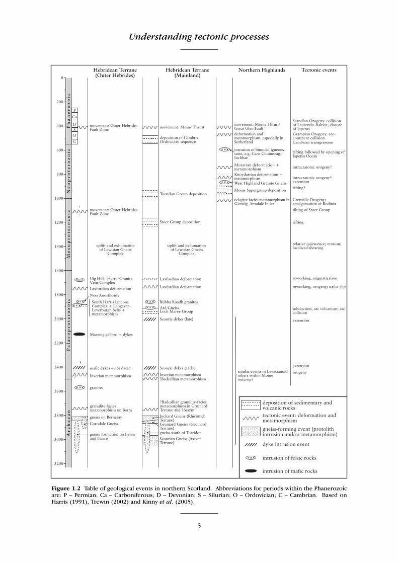
Figure 1.2 Table of geological events in northern Scotland. Abbreviations for periods within the Phanerozoicare: P – Permian; Ca – Carboniferous; D – Devonian; S – Silurian; O – Ordovician; C – Cambrian. Based onHarris (1991), Trewin (2002) and Kinny et al. (2005).

Lewisian, Torridonian and Moine rocks of Scotland: an introduction
6
Lewisian and the Moine, but he did pick out thered Torridonian sandstones and the Cambrianquartzites.
For the next 20 years, only a few geologistsventured into the Northern Highlands (e.g.Cunningham, 1841; Miller, 1841). Then, in1855, a visit to the Northern Highlands wasmade by Roderick Murchison, Director Generalof the Geological Survey, and James Nicol,Professor of Natural History in Aberdeen. Thisvisit was to be the beginning of the ‘HighlandsControversy’. In subsequent years, Murchisonand Nicol visited the area separately, and developed their own theories to explain thestructures that they observed. Murchisonbelieved that the rocks of the NorthernHighlands represented a simple stratigraphicalsequence, with the basement gneisses in thewest overlain eastwards by ‘Cambrian’ sand-stones (the Torridonian), and then by quartzites,limestones and Moine schists, all of which wereconsidered to be Silurian. The Old RedSandstones of the north-east were recognized asDevonian, and considered to be the uppermostpart of this sequence (Murchison, 1858). Nicol,in contrast, considered the Moine schists to beseparated from the rocks to the west by a major(high-angle) fault-line (Nicol, 1860).
With relatively few geologists visiting theNorthern Highlands to investigate the evidencefor themselves, Murchison’s higher standing inthe geological world allowed his views tobecome more widely accepted through the1860s and 1870s. He was supported byArchibald Geikie, a rising star in Scottish geology, who had visited the NorthernHighlands with Murchison, and collaboratedwith him on a new geological map of Scotland(Geikie, 1865).
After Murchison’s death, the issue of the‘Highlands Controversy’ was re-opened towardsthe end of the 1870s (Hicks, 1878), and a number of geologists became interested (seeOldroyd, 1990, for a full review). The mostimportant work of this time was that of CharlesLapworth, who was well aware of ongoing workin the Alps and in North America that showedthe existence of low-angle ‘thrust’ faults inmountain belts. Working east of Loch Eriboll herecognized the complexity of the Moine schists,and showed that they had been deformed andmetamorphosed within an ancient mountainrange, and were separated from the underlyingsedimentary rocks by a major low-angle fault
(Lapworth, 1883). He was also the first personto appreciate that the finely layered rocks immediately above this fault were formed by hightectonic strain, rather than being well-layeredsedimentary rocks. He coined the term‘mylonite’, derived from the Greek mylon (mill),for these rocks (Lapworth, 1885); the term is stillpart of our modern geological vocabulary.
As soon as Lapworth’s work was publicised,Geikie (by now Director General of theGeological Survey) ordered some of his mostable surveyors – including Benjamin Peach andJohn Horne – to begin work in the North-westHighlands. They rapidly came to agree withLapworth, recognizing the existence of low-angle thrust faults that had carried metamorphicrocks westwards over the underlying sedimentaryrocks (Peach and Horne, 1884). The maps andmemoir that were eventually produced todescribe the geology of the North-westHighlands (Peach et al., 1907) were ahead oftheir time as detailed depictions of a thrust belt.These maps have been used for a hundred yearsby generations of geologists studying the classicexample of the Moine Thrust Belt, and are onlynow being revised.
Following the production of the 1907 memoir, the geology of the North-westHighlands was largely considered to be ‘solved’.In the first half of the 20th century, the attentionof the Geological Survey, and of many academics,focused largely on the mapping of the broad,and in some areas rather featureless, tract ofMoine schists; this work is discussed in moredetail in the ‘Introductions’ to Chapters 6, 7 and8. Some initial work was also carried out duringthis time in both the Shetland Isles and theOuter Hebrides.
One of the major features of this period wasthe first use of microscopic techniques in theinterpretation of structural history, building ondetailed early petrographical work such as thatof Jethro Teall (Peach et al., 1907). Analysis ofthe crystallographic preferred orientations ofminerals was pioneered by Frank Coles Phillips,who was the first to apply this type of systematicanalysis to Highlands rocks (Phillips, 1937).Phillips studied the Moine rocks under a micro-scope that was mounted with a ‘universal stage’that allowed the sample to be freely rotatedaround three axes. In this way he gathered alarge amount of petrofabric data, mainly on theorientation of quartz and mica crystals. Helinked these crystallographic orientations to the

Understanding tectonic processes
7
lineations and fold axes that had been measuredin the field in the same rocks. The kinematicinterpretation (i.e. in which way the rocks haddeformed to produce the structures) was to bethe subject of intense debate for several decadesto come (see Howarth and Leake, 2002, for areview). Phillips followed the theory of Sander(1930), which stated that fold axes were perpen-dicular to the ‘tectonic transport direction’. Aslineations were commonly orientated parallel tothe fold axes, the transport direction was thusinterpreted to be perpendicular to the lineation.Hence, Phillips interpreted the lineations in theMoine succession to be formed by tectonic transport in a north-east–south-west direction.As this direction was at right angles to the transport direction of the Moine Thrust, and tothe strike of the Moine succession, it wasthought that these lineations were formed by anearlier, pre-Caledonian orogeny (Phillips, 1945).Not all structural geologists agreed with Phillips’ideas, and even researchers as far away as theUnited States used plots of the structural datafrom the original Geological Survey maps toargue that lineations could be independent fromfold axes (Cloos, 1946). This debate was to lastuntil the 1960s; for instance Christie (1963)argued that thrusting in the Moine Thrust Beltwas locally directed towards the south-west – atright angles to the stretching lineations – but this was contradicted by Johnson (1965). A solution came from the work of Derek Flinn,who carried out detailed work on the deformedLower Palaeozoic Funzie Conglomerate inShetland (Flinn, 1956), and later showed thatneither fold axes nor axial planes necessarilybore any particular relationship to movementdirections (Flinn, 1962), and hence that the theories of Sander (1930) were not universallyapplicable.
Another aspect of interest to geologists in themiddle of the 20th century was the Great Glen,one of the main landscape features of theHighlands. This deep valley formed by erosionalong the Great Glen Fault, which is now knownto have experienced a long and complex history(Harris, 1995; Stewart et al., 1999, 2001). It isclear from the subvertical nature of the fault, and the lack of continuity across the fault trace,that it is a product of large-scale transcurrentmovement. Silurian and mid-Devonian sinistralmovements, and Mesozoic dextral movements,can be readily demonstrated, but the earlier history and age of the structure remain unclear.
Kennedy (1946) postulated that the Strontianand Foyers granitic plutons had originally beenlinked across the Great Glen Fault, implying anoverall sinistral displacement of approximately100 km. Although this idea has been discountedafter modern studies of the two plutons, it didprovide the impetus for similar studies of transcurrent (strike-slip) faults in other parts ofthe world.
Early in the 1950s, interest in the NorthernHighlands was raised by the publication of aseminal paper on the rocks of the LewisianGneiss Complex (Sutton and Watson, 1951).Sutton and Watson recognized two orogeniccycles within the Lewisian; an older Scourianevent and a younger Laxfordian event, separatedby the intrusion of a major dyke-swarm knownas the ‘Scourie dykes’. This work, which drewon previous research in Scandinavia andGreenland, has since been viewed as a bench-mark in the use of field relationships to separatetectonic events in high-grade metamorphicareas.
Sutton and Watson’s work stimulated arenewed interest in the Lewisian GneissComplex, and also generated significant controversy. Some of the new work was readilyaccepted; for instance, the identification of athird metamorphic event, termed the ‘Inverian’(Evans, 1965), which occurred just prior to theintrusion of the Scourie dykes. Dearnley (1962a, 1963) applied the Sutton and Watson chronology to the Outer Hebrides, anddescribed a post-dyke granulite-facies event(‘Early Laxfordian’). Much of the debate aboutLewisian chronology was generated by the suggestion that there was more than oneepisode of Scourie dyke intrusion, and thatsome of the Scourie dykes cut Laxfordian structures (Bowes and Khoury, 1965; Bowes,1968a,b, 1969). However, although most workers in the Lewisian at the time accepted that the Scourie dykes were intruded over a significant period of time, they did not acceptthat phases of dyke intrusion were separated bysignificant orogenic events (Tarney, 1963; Park,1970).
Much of this early controversy was clarified asthe developing techniques of isotopic datingbegan to be applied to the Lewisian gneisses.The earliest isotopic dating of this area was thatof Holmes et al. (1955); they used the potassium-argon technique to date feldspars from Lewisianpegmatites, producing an age of 1090 Ma that

Lewisian, Torridonian and Moine rocks of Scotland: an introduction
8
was taken as a minimum age for the gneisses.However, the first systematic isotopic studyaimed at dating events in the NorthernHighlands was carried out by Giletti et al.(1961), and was the first major paper to comeout of the new age-dating laboratories in Oxford.They used Rb-Sr methods to study a variety ofsamples from the Lewisian Gneiss Complex,chiefly pegmatites, and showed that the Scourianmetamorphism was older than 2460 Ma, whereasthe Laxfordian metamorphism occurred at about1600 Ma. This work was followed by that ofEvans and Tarney (1964), who dated the Scouriedykes at roughly 2200 Ma, and Evans (1965),who gave an age for the Scourian episode ofapproximately 2600 Ma.
Following this, the Oxford group also pioneered the use of lead isotopes to study thehistory of basement gneiss complexes, choosingthe Lewisian Gneiss Complex for their first investigations (Moorbath et al., 1969). Theyshowed that the protoliths of the Lewisiangneisses were largely in existence by about2900 Ma.
Over the last 40 years, a wide variety of isotopic systems have been used to date meta-morphic and igneous events in the LewisianGneiss Complex, and have refined the detail ofthe timescale considerably; nonetheless, thebasic chronology established in these earliestpapers has largely stood the test of time. TheLewisian Gneiss Complex continues to be a testing ground for ever more-sophisticatedmethods of isotopic dating, including use of theRe-Os system (Burton et al., 2000), and dating ofa variety of accessory minerals such as monazite(Zhu et al., 1997a,b). However, controversies over the detailed relationships of the various elements of the Lewisian Gneiss Complex stillcontinue (e.g. Kinny et al., 2005; Mason andBrewer, 2005; Park, 2005).
The paper by Giletti et al. (1961) also included some of the earliest age dates on samples from the Moine. They postulated thatthe main (Caledonian) metamorphism occurredat around 420 Ma. However, pegmatites fromKnoydart and Morar, including some from theKnoydart Mica Mine GCR site, were shown tohave formed before 740 Ma, and this led to thefirst suggestion of a Neoproterozoic metamor-phic event in the Moine. The nature and timingof this event continues to be a source of debate,as discussed in more detail in the chapters dealing with the Moine Supergroup.
At around the time of this dating work, evidence for early deformation in the Moine wasalso being produced by field studies. Althoughthe geometry of deformed rocks had interested geologists from the earliest days of mapping(e.g. Sorby, 1908), it was not until the 1950s thatgeologists began to make use of more-rigorousmathematically based analyses to try to definethe overall three-dimensional nature of foldingand related cleavages. Gilbert Wilson pioneeredsuch methods (Wilson, 1961), but it was his students, encouraged by John Sutton, who combined geometrical analysis with detailedfield mapping in the North-west Highlands andtook such studies to new levels. John Ramsaywas the most notable exponent of this approachand he published a number of landmark papers(Ramsay, 1957a,b, 1960, 1962), in which hedescribed two major episodes of folding in theMoine in Glen Strathfarrar and in the Glenelg–Arnisdale area. Later papers discussed the more-theoretical aspects of strain and folding and culminated in his classic book describing methodsto assess and quantify the folding and fracturingof rocks (Ramsay, 1967). Similar work was beingcarried out elsewhere, but it was in the NorthernHighlands that many of the theoretical modelsand methods were tested.
During the 1970s, the use of modern analyticaltechniques in the Appalachians and the CanadianRockies greatly advanced the internationalunderstanding of the development of thrustbelts (e.g. Dahlstrom, 1970; Boyer and Elliott,1982). In a classic paper, Elliott and Johnson(1980) applied some of these new ideas to try todefine thrust geometry and quantify displace-ments in the northern part of the Moine ThrustBelt. This area was considered to be an impor-tant example of a thrust belt where basement isinvolved in the thrusting. They constructed newbalanced cross-sections, which gave estimates ofthe slip on the Moine Thrust of the order of100 km, and also stated that the movement inthe thrust belt was foreland-propagating. Thiswork stimulated an increased amount ofresearch in the Moine Thrust Belt, which continues to the present day. A major body ofwork was that of Coward (1980, 1982, 1983,1985), who emphasized the importance ofextensional faults within the Moine Thrust Belt.He suggested that gravity spreading was animportant feature of the later stages of movement on the Moine Thrust Belt, with thereactivation of some existing thrust features as

Tectonic setting and evolution of the Northern Highlands
9
extensional faults. Coward (1985) recognizedthat the classic example of the Moine Thrust atKnockan Crag, in southern Assynt, was actually a late extensional fault. Continuing work (e.g.Butler and Coward, 1984; Butler, 1987, 2004a) illustrated the complexity of the Moine ThrustBelt, with the recognition of breaching and back-thrust systems. This work emphasized theimportance of the thrust belt as a well-exposed,easily accessible testing ground for new theories,as well as a classic locality for teaching.
In tandem with the work on major structuresin the field, the microscopic study of rock fabricswas also being used to investigate micro -structures. From the 1950s onwards, more andmore rock deformation experiments were performed in laboratories around the world(e.g. Griggs and Handin, 1960). What wasrequired was a real rock that was highly strainedbut with a simple mineralogy, so that the naturalmicrostructures could be compared with thoseobtained by experiments in the lab. Wilkinson etal. (1975) used the deformed Skolithos pipes inthe Pipe Rock as strain markers to enable themto determine the finite strain in the shearedquartzites. Such rock was ideal for detailed crystallographic studies: it was highly strainedand composed dominantly of quartz, whichcould be used for the measurement of quartz c-axes. These measurements could then be correlated with independent determinations ofstrain obtained from the deformed pipes.Numerous publications followed in which themicrofabrics and the microtextures of the quartzmylonites in the Moine Thrust Belt were deter-mined (e.g. White et al., 1982; Law et al., 1986;Law, 1987). This work was compared to computer-simulations of the development ofmicrofabrics by workers in Europe and Australia(e.g. Lister and Hobbs, 1980), and led to a thorough understanding of the deformationmechanisms involved in high-strain zones. Themain conclusions of these studies still standtoday (e.g. review by Law, 1990).
This section has discussed some of the mostinternationally significant pieces of work thathave been published on the Northern Highlands.However, much of our understanding of the area has come from our gradual build-up ofknowledge over 150 years of detailed fieldworkand analysis by many different geologists. Workof this type is drawn on heavily in this volume,and includes the detailed studies of the sedimentology and tectonic setting of the
‘Torridonian’ rocks by Sandy Stewart (e.g.Stewart, 1969, 1975, 1982, 1988a,b, and this volume); work on the Lewisian Gneiss Complexby Graham Park (e.g. Park, 1964, 1966, 1970,2002, and this volume; Park et al., 1994, 2001);and investigations across the Shetland Isles by Derek Flinn (e.g. Flinn, 1967, 1985, 1988,1994, and this volume). Full details of much of this work are given in the relevant chapterintroductions.
At the time of writing, debate about many geological questions in the Northern Highlandsis as lively and as international as ever, and someof the ongoing controversies are discussed in thenext section.
TECTONIC SETTING AND EVOLUTION OF THE NORTHERN HIGHLANDS
M. Krabbendam, J.R. Mendum and K.M.Goodenough
For much of Precambrian time, northernScotland was part of a continental block that alsoincorporated parts of present-day North Americaand Greenland. At various times within thePrecambrian, this block was included withinlarger supercontinents; but towards the end ofthe Precambrian, it became a separate continentknown as ‘Laurentia’. As a result of this commonhistory, many rock units and events in Scotlandcan be correlated with parts of the geologicalrecord in Greenland and north-eastern NorthAmerica (Figure 1.3). Some correlations are alsopossible with the palaeocontinent of Baltica,which was composed of parts of present-dayScandinavia and Russia. For the purposes of thisreview, the terms ‘Laurentia’ and ‘Baltica’ areused to refer to these blocks of continental crust,even prior to their development as separate continents.
The Archaean tectonic history of the basementof northern Scotland is complex and still thesource of debate, as discussed below. Duringmuch of the Proterozoic, Laurentia and Balticaformed part of a single supercontinent, althoughthere were episodes of extension and riftingsuch as that recorded by the MesoproterozoicStoer Group. Eventually, both Laurentia andBaltica became part of the supercontinent ofRodinia, which was assembled during theGrenville Orogeny at around 1100 Ma.

Lewisian, Torridonian and Moine rocks of Scotland: an introduction
10
At around 600 Ma, a major rifting event beganto split Rodinia into several separate blocks. Amajor ocean, known as ‘Iapetus’ (named afterthe father of Atlas in Greek mythology), developed at about 570–580 Ma. This oceanseparated Laurentia from two major continentalmasses, Gondwana to the south and Baltica tothe east. The Iapetus Ocean reached its greatestextent – about 2000 km in width – at around500 Ma, but then began to close rapidly. Duringthe Silurian Period, Laurentia and Baltica collidedagain, resulting in the formation of the MoineThrust Belt. The Iapetus Ocean was finallyclosed during the Silurian by the docking of acontinent called Avalonia – containing Englandand Wales – with Laurentia. Scotland remained
part of Laurentia until the opening of the NorthAtlantic during the Palaeogene around 53 Ma.
Thus, it is clear that most of the rock unitsdescribed in this volume can be better correlatedwith parts of North America and Greenland thanwith other parts of Great Britain. Large parts of the Lewisian Gneiss Complex have beenmatched with gneisses of the NagssugtoqidianBelt in southern and central Greenland, whilstthe Moine Supergroup has been tentatively correlated with similar sequences of metamorphosed sedimentary rocks in south-eastGreenland.
The Northern Highlands were situated closeto the margin of Laurentia, where they experienced several collisional events, and thus
Figure 1.3 Palaeogeographical reconstruction of Laurentia and Baltica, showing Archaean cratons andPalaeoproterozoic belts. After Buchan et al. (2000).

Tectonic setting and evolution of the Northern Highlands
11
they preserve a unique record of Neoproterozoicand Palaeozoic orogenic activity. Even theMesoproterozoic Grenville Orogeny has beenrecorded, in the Glenelg–Attadale Inlier, despitethe fact that younger deposits probably obscuremost of the evidence for Grenvillian orogenesisin Scotland. As a result, the Grenville Front inNorth America can be linked, through Scotland,to the Sveconorwegian Front in Scandinavia.Similarly, the Moine Thrust Belt provides a keylink in the western front of the CaledonianOrogeny. This western Caledonian Front can befollowed from east Greenland, through Scotlandto Newfoundland, whilst the eastern CaledonianFront runs through Norway and Sweden.
The major events in the tectonic history ofnorthern Scotland are discussed in more detailbelow. Good, recent overviews of the tectonicsetting and evolution of this area are also givenin Woodcock and Strachan (2000) and Trewin(2002).
Archaean
Most of the gneisses of the Lewisian GneissComplex formed during the Late Archaean astypical ‘TTG’ (tonalite–‘trondjhemite’–granodiorite;see glossary) plutonic suites intruded into lower levels of the crust. ‘TTG’ suites character-ize much of the Earth’s Archaean crust, but modern analogues are rare. However, the rare-earth-element and trace-element geochemistryof the quartzofeldspathic Lewisian gneisses isbroadly similar to that of plutonic rocks formedabove modern-day subduction zones. It is thuslikely that the protoliths of the gneisses formedat active plate margins, although possibly withmelting at rather shallower depths than in modern sub duction zones (Park and Tarney,1987; Rollinson, 1996). The later reworking ofthe Lewisian Gneiss Complex was so pervasiveand varied that it is now difficult to unravel the original relationships of these igneous protoliths.
Traditionally, the whole of the LewisianGneiss Complex was thought to be part of thesame block of crust. The mainland Lewisian canbe divided into Northern, Central and Southernregions, each with different deformation histories(Peach et al., 1907; Sutton and Watson, 1951),and the Lewisian Gneiss Complex in the OuterHebrides has generally been considered to havea comparable history to parts of the mainlandLewisian (Fettes and Mendum, 1987).
However, recent use of isotopic dating techniques – notably U-Pb dating of zircon andother accessory minerals – has resulted in therecognition of a number of discrete intrusiveevents, which occurred in different areas of theLewisian Gneiss Complex between 3100 Ma and2650 Ma (Kinny and Friend, 1997; Whitehouseet al., 1997a; Corfu et al., 1998; Friend andKinny, 2001; Love et al., 2004). On this basis, ithas been proposed that the Lewisian basement consists of several separate terranes (Figure 1.4),which are characterized by protoliths of differentages, and by different Archaean and Palaeo -proterozoic histories (Kinny et al., 2005).However, the nature of these Archaean and laterevents, and the precise location and significanceof the terrane boundaries, remain the subject ofongoing debate (e.g. Mason and Brewer, 2005;Park, 2005).
The oldest gneisses include those on Lewisand North Harris, and also the southernmostoutcrops of the mainland, with protolith agesbetween 3125 Ma and 2800 Ma. On the main-land, the gneisses in the northern part of theCentral Region (the Assynt Terrane of Kinny etal., 2005) also have protolith ages aroundc. 3000 Ma, whilst those in the Northern Region(the Rhiconich Terrane) have protolith ages thatrange between 2840 Ma and 2680 Ma. Thegneisses of the Northern Region are known tohave distinctly higher K, Rb, U and Th contentsthan those of the Central Region (Sheraton etal., 1973), although it is difficult to ascertainwhether this is a primary feature (Tarney andWeaver, 1987a). The gneisses of the southernpart of the Central Region (the Gruinard Terrane) have similar protolith ages to gneisseson eastern Barra, around 2840 Ma. Friend andKinny (2001) suggested that the gneiss terranesof the western Outer Hebrides can be correlatedreasonably well with gneiss terranes in eastGreenland (Figure 1.4) on the basis of their composition, protolith and reworking ages.However, basement gneisses occur extensivelyoffshore on the Hebrides Shelf, and probablyform the foundation of the Rockall Plateau, andtherefore correlations between the OuterHebrides and Greenland remain somewhat speculative.
During latest Archaean and earliestPalaeoproterozoic times, parts of the LewisianGneiss Complex were affected by granulite-facies metamorphism. This metamorphic eventwas originally recognized by Sutton and Watson

Lewisian, Torridonian and Moine rocks of Scotland: an introduction
12
(1951) in the Central Region of the mainlandLewisian, and termed the ‘Scourian’ event; it waslater renamed ‘Badcallian’ by Park (1970). Themost recent work (Zhu et al., 1997a,b; Love etal., 2004; Kinny et al., 2005) has identified two
different high-grade events, one at approximately2730 Ma that has been recognized in the gneissesof Barra and of the Gruinard Terrane, and a second at 2490 Ma recognized in the AssyntTerrane. However, the tectonic setting of these
Figure 1.4 Map of suggested terranes in the Lewisian Gneiss Complex of the Outer Hebrides and mainland Scotland, with a summary of isotopic dates. Based on Friend and Kinny (2001) and Kinny et al.(2005).

Tectonic setting and evolution of the Northern Highlands
13
events is unclear. A subsequent amphibolite-facies deformation event, the Inverian event, hasbeen recognized across the Central Region (i.e.in both the Assynt and Gruinard terranes). Thisevent had largely ended by the time of emplace-ment of the major Scourie Dyke Suite, and thusoccurred between 2490 Ma and 2400 Ma (Friendand Kinny, 2001; Park et al., 2001; Kinny et al.,2005).
Palaeoproterozoic
Following the Badcallian and Inverian tectono -thermal events, there was a period of significantcrustal extension, possibly related to riftingacross an Archaean continental mass. The mainevidence for this comes from the presence ofmajor swarms of mafic and ultramafic dykesacross Laurentia and Baltica, such as the2480–2450 Ma Matachewan Dyke Swarm inOntario (Heaman, 1997). On the Scottish main-land, the Palaeoproterozoic dykes are known asthe ‘Scourie Dyke Suite’, and they have been correlated with a similar swarm of mafic dykes in the Outer Hebrides (the ‘Younger Basics’ ofFettes and Mendum (1987)). Dykes from theswarm have only been dated in the Assynt area,where two phases of intrusion were recognized:the first at c. 2400 Ma and a second at c. 2000 Ma(Heaman and Tarney, 1989; Waters et al., 1990).The rifting episode was also recorded by thedevelopment of extensional rift basins, in whichvoluminous volcanic and sedimentary sequenceswere formed. In the Lapland–Kola Belt ofBaltica, with which the Lewisian GneissComplex is commonly correlated (see Buchan etal., 2000), the Sumi–Sariola Group includes volcanic sequences, mafic intrusions and dykesthat were formed at this time (Amelin et al.,1995; Hanski et al., 2001).
From about 2000 Ma, the extensional tectonicregime was replaced by the development of subduction zones and the onset of convergenttectonics. Within the mainland Lewisian, themajor evidence for this tectonic regime comesfrom the Loch Maree Group. This unit comprisesmetamorphosed mafic volcanic rocks and a rangeof associated metasedimentary rocks. Detritalzircon ages show that the metasedimentary rocksof the Loch Maree Group are younger thanapproximately 2000 Ma, and they are intruded bythe c. 1905 Ma Ard Gneisses, which define theyounger age limit of deposition (Park et al., 2001;Park, 2002). The geochemistry of the Ard
Gneisses indicates that they were formed abovea subduction zone. Park et al. (2001) interpretedthe Loch Maree Group as a juvenile subduction–accretion complex, suggesting that the volcanicand sedimentary units were formed in an oceanic setting and then tectonically juxtaposedin a collisional suture zone between two blocksof Archaean continental crust. The Ard Gneisseswere intruded following the accretion of the volcano-sedimentary succession.
As well as the Loch Maree Group, two mainbelts of Palaeoproterozoic, mainly arc-relatedrocks occur on the Outer Hebrides. In the farnorth of Lewis is the Ness gabbro–anorthositecomplex, dated at c. 1860 Ma (Whitehouse,1990b; Whitehouse and Bridgwater, 2001). InSouth Harris, the South Harris Igneous Complex(SHIC) is flanked by the metasedimentaryLangavat and Leverburgh belts to the north andsouth respectively; together these make up theRoineabhal Terrane of Friend and Kinny (2001).The SHIC comprises a gabbro–anorthosite unitand bodies of mafic tonalite and diorite; the latter intruded at c. 1890 Ma (Friend and Kinny,2001; Mason et al., 2004a). The metasedimen-tary rocks contain abundant detrital zircons thathave similar ages to the intrusions. Thus, thesediments may have been derived from the high-level volcanic equivalent of the SHIC (Friendand Kinny, 2001; Whitehouse and Bridgwater,2001). The tonalitic and dioritic igneous rockshave a calc-alkaline character (Fettes et al.,1992) and the Roineabhal Terrane is consideredto represent a magmatic–accretionary arc complex, developing into a collisional arc system, similar to, but slightly younger than theLoch Maree arc system (Baba, 1998).
Subduction and formation of magmatic arcswas rapidly followed by a period of collisionaltectonics with associated magmatism and metamorphism. The sedimentary and igneousrocks of the Roineabhal Terrane were subjectedto very high-pressure granulite-facies meta -morphism at c. 1870–1830 Ma, followed byrapid uplift (Cliff et al., 1998; Baba, 1999a;Whitehouse and Bridgwater, 2001). In thenorthern part of the mainland Lewisian, a majorthermal event caused localized melting, approxi -mately coeval with the intrusion of a series ofgranite and pegmatitic granite sheets (the RubhaRuadh granites) at c. 1855 Ma (Friend and Kinny,2001).
More-widespread reworking occurred on themainland at c. 1740 Ma, during the Laxfordian

Lewisian, Torridonian and Moine rocks of Scotland: an introduction
14
event (Corfu et al., 1994; Kinny and Friend,1997). The Laxfordian event included wide-spread retrogressive amphibolite- to greenschist-facies metamorphism, folding and shearing. Itaffected most of the gneisses of the mainland,from the north coast southward to the LochMaree Group. A second reworking event,including migmatization and granite veining,occurred on the Outer Hebrides and acrossmuch of the mainland at c. 1675 Ma (Corfu etal., 1994; Mason et al., 2004b). Low-strain areasthat have not been affected by these reworkingevents occur within the Lewisian GneissComplex, and in places these preserve earlier,unmodified Archaean and Palaeoproterozoic features and structures.
The Palaeoproterozoic sedimentation and arc-related magmatism, and the subsequentreworking event, also have their correlatives inBaltica and Laurentia (Figure 1.3). In bothBaltica and Laurentia, large amounts of juvenilecrust were generated by arc magmatism to thesouth of the major Archaean cratons. Examplesinclude the Svecofennian Province (1900–1850 Ma) in Baltica, and the Penokean,Ketilidian and Makkovik belts (1900–1800 Ma)and the Yavapai Province (1800–1700 Ma) inLaurentia (e.g. Hoffman, 1988). The Lewisiangneisses are generally considered to correlatewith the Nagssugtoqidian Belt of Greenland and the Lapland–Kola Belt of Scandinavia (e.g.Park, 1994; Buchan et al., 2000). TheNagssugtoqidian Belt consists of Archaeangneisses that were intensely reworked in thePalaeoproterozoic, together with Palaeo -proterozoic arc-related intrusions dating from1920 Ma to 1760 Ma (Whitehouse et al., 1998).Similarly, the Lapland–Kola Belt containsreworked Archaean crust and Palaeoproterozoicarc-related intrusions.
Mesoproterozoic
Following the Palaeoproterozoic orogenesisdescribed above, there was a period of relativetectonic quiescence, during which the Lewisiangneisses were uplifted and exhumed. Around1300 million years ago, extension and riftingcommenced once again (Figure 1.5a,b). Theonset of rifting was marked by intrusion of large-scale mafic dyke-swarms across parts ofLaurentia and Baltica, including the c. 1270 MaMackenzie Dyke Swarm in Canada (Le
Cheminant and Heaman, 1989), and the1350–1140 Ma Gardar Province in southernGreenland (Upton et al., 2003).
In Scotland, the Mesoproterozoic rifting wasmarked by the deposition of the Stoer Group, asedimentary sequence of which some 2 km inthickness is preserved around the Bay of Stoer.It is largely composed of fluvial breccias, conglomerates, sandstones, and siltstones, witha single volcaniclastic member. The successionis interpreted as having been deposited in afault-bounded rift basin (Stewart, 1982, 2002;Rainbird et al., 2001) at around 1200 Ma(Turnbull et al., 1996).
Towards the end of the Mesoproterozoic,extensional tectonics again gave way to a collisional regime, and a series of mountain beltswas formed around the globe from 1100 Ma to950 Ma (Figure 1.5c). This mountain-buildingevent, generally referred to as the ‘Grenvillian’after its type area in North America, led to amalgamation of the supercontinent of Rodinia.Reconstructions of this supercontinent, basedon palaeomagnetic work, generally place Baltica,Laurentia and Amazonia adjacent to each other(Figure 1.5c), with northern Scotland positionedclose to the triple junction (e.g. Torsvik et al.,1996; Dalziel, 1997; Holdsworth et al., 2000).In eastern Canada, the Grenvillian Orogen iswell exposed, and there is a clearly definedGrenville Front (e.g. Rivers, 1997; Gower andKrogh, 2002). However, in Scotland, evidencefor Grenvillian orogenesis is sparse and it is notpossible to map out the Grenville Front, mainlybecause of the extensive cover of post-Grenvillemetasedimentary rocks. The Outer HebridesFault Zone appears to have been initiated during the Grenvillian, with ductile thrusting at approximately 1100 Ma (Fettes et al., 1992;Imber et al., 2002). Further evidence for theGrenvillian in Scotland comes from theArchaean and Palaeoproterozoic gneisses of theGlenelg–Attadale Inlier, which are surroundedby rocks of the Moine Supergroup. In the inlier,eclogite-facies metamorphism and subsequentamphibolite-facies retrogression has been datedat approximately 1000 Ma (Sanders et al., 1984;Brewer et al., 2003; Storey et al., 2004).Eclogite-facies rocks of similar age also occur inthe eastern Grenville Province in Canada (e.g.Indares and Dunning, 1997) and in theSveconorwegian Orogen in south-west Sweden (Möller, 1998), confirming on the

Tectonic setting and evolution of the Northern Highlands
15
one hand the position of northern Scotland on the margin of Laurentia, and on the otherhand the continuity of the Grenvillian–Sveconorwegian Orogen.
Neoproterozoic sedimentation
Towards the end of the Grenvillian Orogeny,thick sedimentary successions were depositedwidely across the North Atlantic region (Figure1.5d). In northern Scotland, two mainNeoproterozoic sedimentary sequences are recognized, the Torridon Group and the MoineSupergroup. The Torridon Group is up to 7 kmthick and dominated by fluviatile, cross-beddedred sandstones. These sediments were depositedby braided river systems, with palaeocurrent
indicators suggesting transport from the west.The age of the Torridon Group is constrained by detrital zircon studies as younger thanapproximately 1060 Ma (Rainbird et al., 2001).Diagenesis has been dated at roughly 1000–970 Ma (Turnbull et al., 1996), ages consideredto be close to the time of deposition.Deposition of the Torridon Group was thusapproximately coeval with the waning stages ofthe Grenvillian Orogeny.
Stewart (1982, 2002) and Williams (2001)argued for deposition of the Torridon Group ina half-graben rift system, with a bounding faultsituated close to the present-day Minch Fault,just to the east of the Outer Hebrides. Thisinterpretation was contested by Nicholson(1993) who argued that the river systems
Figure 1.5 Generalized palaeogeography of Laurentia and Baltica during the period 1300–870 Ma, showing thesetting of deposition of the Stoer, Torridon and Moine sequences. Hatched areas show locations of sedimen-tary deposition. T – Torridon Group; Mo – Moine Supergroup; Kr – Krummedal sequence. After Strachan andHoldsworth (2000).

Lewisian, Torridonian and Moine rocks of Scotland: an introduction
16
depositing the sandstones must have been muchlarger and longer – of the order of 1000 km.Moreover, detrital zircon data for the TorridonGroup include very few Archaean zircons(Rainbird et al., 2001); the majority of zirconsare dated at around 1650 Ma, suggesting asource outside the Lewisian Gneiss Complex.Rainbird et al. (2001) and Prave et al. (2002)suggested that the Torridon Group may represent a foreland basin to the Grenvillianmountain belt, with a significant amount of sedimentary material derived from the Labradorsegment of the orogen.
The Moine Supergroup comprises a thick andextensive sequence of siliciclastic metasedimen-tary rocks, dominated by psammites and withsubordinate pelites. It is divided into threegroups; the Morar, Glenfinnan and Loch Eilgroups (Johnstone et al., 1969). Sedimentaryevidence that indicates deposition in a shallow-marine environment, including cross-bedding, ispresent in much of the sequence. It has beensuggested that Moine sedimentation occurred intwo major rift basins, each forming a half-graben(Soper et al., 1998). However, an alternativepossibility has been raised by Cawood et al.(2004), who suggested deposition in a singleslowly subsiding, regionally extensive basin.
The nature of its basal contact has been thesubject of much discussion, but it is now generally accepted that the Moine Supergroupwas unconformably deposited upon a crystalline‘Lewisianoid’ basement, with locally preservedbasal conglomerates (Peach et al., 1907; Ramsay,1957b; Holdsworth, 1989a). The Lewisianoidbasement is exposed in a series of inliers, eitheras thrust slices or as antiformal keels.
The maximum age of Moine deposition isconstrained by the youngest detrital zircons atc. 950 Ma (Kinny et al., 1999; Friend et al.,2003), and the minimum age by the intrusion ofthe West Highland Granite Gneiss Suite atc. 870 Ma (Friend et al., 1997). From these constraints, the Moine Supergroup appears tobe broadly coeval with, or slightly younger than,the Torridon Group. Indeed, a correlationbetween the Moine and Torridon sequence wasfirst made by Geikie (1893), and favoured byPeach (Peach and Horne, 1930). However, theMoine and Torridonian detrital zircon patternsare rather different from each other, indicatingthat deposition in the two sedimentary basinswas probably separated, either temporally orspatially (Friend et al., 2003; Cawood et al.,
2004). Krabbendam et al. (2008) recently arguedthat the upper parts of the Torrridonian succession (Torridon Group) are directly equivalent to the lower parts of the MoineSupergroup (Morar Group) in Sutherland.
Archaean detrital zircons are virtually absentfrom the Moine psammites, except for somebasal units, and thus the Moine sediments areunlikely to have been derived from a source inthe Lewisian Gneiss Complex (Friend et al.,2003). It is most likely that they were derived, atleast in part, from erosion of the Grenvillianmountain belt (Cawood et al., 2007; Krabbendamet al., 2008). The Moine Supergroup showssome similarities in lithology and detrital zirconcontent to the Krummedal sequence in eastGreenland (Leslie and Nutman, 2003; Cawoodet al., 2004). Thus, the basin in which the Moinesiliciclastic sediments were deposited was prob-ably considerably larger than the Moine outcropas preserved today.
Neoproterozoic tectonothermalevents
Evidence for a number of magmatic and meta-morphic events during the Neoproterozoic ispreserved within the Moine Supergroup.Although it is clear that this part of Laurentia hasa complex tectonic history, the detail of individualorogenic events has proved difficult to unraveland is still the subject of considerable academicdebate. At the time of writing, the followingsummary can be made.
At c. 870 Ma, the Moine Supergroup wasintruded by granitic sheets that were derivedfrom melting of metasedimentary rocks (theWest Highland Granite Gneiss Suite). Thesewere preferentially emplaced around theGlenfinnan Group–Loch Eil Group boundary(Friend et al., 1997; Rogers et al., 2001).Associated metabasic intrusions, with tholeiitic,MORB-like chemistry, have yielded the sameintrusive age (Millar, 1999). This type ofbimodal igneous event is typical of an intra-continental rift setting. Although the formationof the West Highland Granite Gneiss Suite haspreviously been attributed to a contractional,orogenic event (Friend et al., 1997), an extensional rifting hypothesis for the c. 870 Maevent is now generally accepted (e.g. Ryan andSoper, 2001). It is likely that this event represents the development of a failed riftbetween Baltica and Laurentia (Figure 1.5d).

Tectonic setting and evolution of the Northern Highlands
17
Numerous dates on pegmatites and, morerecently, on metamorphic minerals have shownthat the Moine rocks experienced tectono -thermal events in the periods 820–780 Ma and750–730 Ma (Giletti et al., 1961; Long andLambert, 1963; van Breemen et al., 1974, 1978;Powell et al., 1983; Piasecki and van Breemen,1983; Rogers et al., 1998; Vance et al., 1998; Zehand Millar, 2001; Tanner and Evans, 2003).These events have been variously termed‘Knoydartian’ (Bowes, 1968a) and ‘Morarian’(Lambert, 1969), with Knoydartian now generallybeing used for the 820–780 Ma period andMorarian for the later events. The dates andtheir interpretation have been the source of along-standing controversy. Soper and England(1995) envisaged that the Neoproterozoic evolution of the Scottish part of the Laurentianmargin was dominated by rifting and extension,without any contractional orogenic events.However, by linking isotopic age dating withmetamorphic P–T data, recent work has shownthat at least some of the Knoydartian events arecontractional (Vance et al., 1998; Zeh and Millar,2001; Tanner and Evans, 2003). It has generallybeen difficult to assign specific structures withinthe Moine to the Neoproterozoic orogenicevents, although initiation of the major SgurrBeag Thrust is now interpreted as being ofNeoproterozoic age (Tanner and Evans, 2003).
On a larger scale, Neoproterozoic orogens are problematical in the sense that palaeo -geographical reconstructions show Scotlandpositioned within a Rodinian supercontinent atthat time (Figure 1.6a), and there is no evidenceof similar-aged orogenesis in North America(Cawood et al., 2004). As well as in northernScotland, evidence of Neoproterozoic (840–800 Ma) compressional tectonics has beenfound in the Dava–Glen Banchor Succession(formerly Central Highlands Complex orDivision) south of the Great Glen (e.g. Noble etal., 1996; Highton et al., 1999). Farther afield,c. 840–800 Ma igneous activity in northernmostNorway has been attributed to a ‘Porsangerorogeny’ (Daly et al., 1991; Kirkland and Daly,2004), which may have been associated with theevents in Scotland. Park (1992) suggested thatat c. 800–750 Ma sinistral strike-slip motionoccurred between Baltica and Laurentia.Nevertheless, the extent, nature, evolution andtectonic setting of the Knoydartian/Morarianorogenic events in Scotland remain largely unresolved.
Towards the end of the Neoproterozoic, thesupercontinent of Rodinia again began to riftand eventually broke up (Figure 1.6b). TheIapetus Ocean started to open betweenLaurentia and Baltica after c. 600 Ma, althoughrifting and extensionally related sedimentationmay have started much earlier. Clear evidencefor rifting at c. 600 Ma is preserved in theDalradian Supergroup of the GrampianHighlands. This thick metasedimentary unit represents a rift–drift transition and containsmafic and felsic igneous rocks dated between595 Ma and 600 Ma (Halliday et al., 1989; G.Rogers et al., 1989; Dempster et al., 2002).Details of these events are described in theDalradian Rocks of Scotland GCR Volume (inprep.).
North-west of the Great Glen, the main evidence for the onset of Iapetan opening lies ina variety of igneous rocks intruded into theMoine Supergroup. The Berriedale and Braevalaugen granites, within the Moine Supergroup ofCaithness, have been dated at 590–600 Ma(Kinny et al., 2003b). The Carn Chuinneag–Inchbae Igneous Complex contains deformedmafic and granitic intrusions, and includes somealkaline rocks (Harker, 1962; Wilson andShepherd, 1979), which provide evidence for acontinental rift setting. The complex has beendated at approximately 610 Ma (Kinny et al.,2003b). Amphibolites with alkaline chemistry(the Loch a’ Mhoid Metadolerite Suite;Moorhouse and Moorhouse, 1979) are found asintrusions in the Moine of Sutherland, and pre-liminary data suggests that these also have a lateNeoproterozoic age (P. Kinny and R.A. Strachan,pers. comm.).
Cambrian–Early Ordovician
At the start of the Cambrian, the Iapetus Oceanhad opened to a width of around 2000 km(Figure 1.6c). A thick marine sedimentary succession – the Dalradian Supergroup – hadbeen deposited in the area now occupied by theGrampian Highlands. The upper part of thissequence was deposited between 600 Ma and520 Ma, during which time a rift–drift successionformed. Farther inland, deposition only startedwith a significant marine transgression in theCambrian, and sediments were deposited on awide, shallow shelf. These sediments formedthe Cambro–Ordovician sequence of the North-west Highlands, comprising quartzite at the base

Lewisian, Torridonian and Moine rocks of Scotland: an introduction
18

Tectonic setting and evolution of the Northern Highlands
19
and a carbonate sequence at the top. Thesequence is described in detail in GCR Volume 18 (Rushton et al., 2000). The basalunconformity of the sequence is remarkably planar, showing that the tilted Torridonian rockshad been eroded to a near-level peneplain, whichwas flooded during the Cambrian transgression.The Cambro–Ordovician sequence in Scotlandcan be wholly or partially correlated withsequences in Newfoundland, east Greenland andSvalbard (Swett and Smit, 1972; Cowie, 1974;Wright and Knight, 1995; Smith et al., 2004)showing that a continuous passive margin existedalong the Laurentian margin, from northGreenland through Scotland to Newfoundland.
Early Ordovician to Silurian: theCaledonian Orogeny
From about 520 Ma, the Iapetus Ocean began tonarrow again. The early Ordovician GrampianEvent was the first collisional event to affect theScottish part of the Laurentian margin, and wasthe first phase of the Caledonian Orogeny. Thisevent is regarded as having been caused by thecollision of an arc terrane against the Laurentianpassive margin (Van Staal et al., 1998; Oliver,2001; see Figure 1.6d). Remnants of the arc aredifficult to pinpoint, but may occur at depth in
the Midland Valley or beneath part of theSouthern Highlands. It is clear that this colli-sional event was relatively short-lived, and itsculmination is constrained in both westernIreland and Scotland to between 475 Ma and465 Ma (Dewey and Mange, 1999; Soper et al.,1999; Oliver, 2001). Most Grampian deforma-tion and metamorphism in Scotland occurredsouth-east of the Great Glen, in the GrampianHighlands. North of the Great Glen, most deformation appears to be Scandian (see below)or Knoydartian (see above), but some significantGrampian tectonic and metamorphic effectshave also been proven.
The Sgurr Beag Thrust, which carries theGlenfinnan Group of the Moine over the MorarGroup, has been generally attributed to theGrampian Event (e.g. Powell et al., 1981; Harris,1995). However, Tanner and Evans (2003)demonstrated that the first movement of thisthrust could be related to Knoydartian deforma-tion, although it was reactivated during theGrampian Event. Migmatization in thrust sheetsto the east of, and structurally above, the SgurrBeag Thrust is now considered to be Ordovicianin age and related to the Grampian Event (Kinnyet al., 1999). Farther to the east, a c. 470 Ma agefor titanite in the West Highland Granite GneissSuite near Fort Augustus has been interpreted as dating a regional amphibolite-facies metamor-phism (Rogers et al., 2001). The onset of theGrampian Event may also have led to minoruplift in the foreland areas of north-westScotland, resulting in the cessation of Cambro–Ordovician sedimentation (e.g. Soper et al.,1999).
The Scandian Event (the second main phaseof the Caledonian Orogeny) occurred betweenc. 438 Ma and 425 Ma. It coincided with thefinal closure of the Iapetus Ocean, and the docking of Avalonia, but mainly results from thecollision of Baltica with Laurentia (Figure 1.6e,f).The most prominent structure ascribed to theScandian Event in Britain is the Moine ThrustBelt, which effectively represents the front of theCaledonian Orogeny in Scotland. The exact ageof the thrust belt is the source of some debate.Thrusts within the Moine Thrust Belt are cut by the Loch Borralan Syenitic Pluton (Parsonsand McKirdy, 1983), which have been dated at430 ± 4 Ma (van Breemen et al., 1979a).However, dating of micas in Moine schists andmylonites has indicated that ductile deformation
=Figure 1.6 Palaeogeographical reconstructionsfrom the Neoproterozoic to the Silurian. (a) Thesupercontinent Rodinia at c. 750 Ma. The Grenvillian orogenic belts that welded the Rodinia continenttogether are indicated. Rifting has commencedbetween Laurentia and East Gondwana. (b) Mid-Neoproterozoic, c. 600–580 Ma. Rifting between thecontinents of Laurentia, Baltica and Amazonia. (c)Neoproterozoic–Cambrian, c. 550–540 Ma. TheIapetus Ocean is at its widest. Clastic and carbonatedeposition occurs along the southern margin ofLaurentia. (d) Ordovician, c. 470 Ma. The IapetusOcean is in the process of closing. Collision of oceanicand microcontinental arcs with Laurentia (e.g. theMidland Valley Terrane), results in the GrampianEvent in Scotland and the Taconic Event in NorthAmerica. (e) Early Silurian, c. 440 Ma. Collision ofperi-Gondwanan continental terranes, notablyAvalonia, with Laurentia as the Iapetus Ocean closesand the Rheic Ocean widens. The start of theScandian Event. (f) Silurian, c. 425 Ma. Final closureof Iapetus and Tornquist oceans. Collision of Balticaand Greenland (Laurentia) gives rise to the mainScandian Event (438–425 Ma). MVT – Midland ValleyTerrane. Based on Torsvik et al. (1996) andHoldsworth et al. (2000).

Lewisian, Torridonian and Moine rocks of Scotland: an introduction
20
may have occurred along at least some parts ofthe Moine Thrust Belt as late as c. 410 Ma(Kelley, 1988; Freeman et al., 1998; Dallmeyer etal., 2001). Ductile deformation also occurredfarther to the east within the Moine rocks, with anumber of ductile thrusts (e.g. the Sgurr Beag and Naver thrusts) thought to have operated or been reactivated during theScandian Event (Strachan et al., 2002a). To thewest of the Moine Thrust Belt, the ScandianEvent had little effect on the rocks of the foreland, except for movements along the OuterHebrides Fault Zone (Kelley et al., 1994; Imberet al., 2002).
Displacement along the Moine Thrust wasdominantly to the WNW, but farther to the east inthe Moine succession lineations swing to a morenorth–south trend, possibly reflecting earliermovements (Phillips, 1937; Strachan et al.,2002a). The amount of displacement taken upwithin the imbricates of the Moine Thrust Belthas been estimated at between 50 km and100 km (Elliott and Johnson, 1980; Butler andCoward, 1984). Similar amounts of displace-ment may have occurred in the mylonites thatdirectly overlie the Moine Thrust. Farther east,significant shortening occurred across the more-ductile thrusts such as the Ben Hope, Naver andSwordly thrusts in Sutherland (Barr et al., 1986;Strachan et al., 2002a). In its entirety, theScandian Event resulted in significant crustalshortening, probably in excess of 150 km.Farther north, in east Greenland, a fold-and-thrust belt showing similar characteristics alsodeveloped. In Scandinavia a fold-and-thrust beltwith the opposite, easterly vergence developed,and is characterized by the presence of severallarge discrete thrust sheets.
Towards the end of the Scandian Event, sinistral strike-slip displacements occurred alongan array of NE-trending, steep faults, which innorthern Scotland include the Great Glen Fault,the Strathconon Fault and the Strathglass Fault.These fault movements marked the start of aperiod of widespread orogenic uplift and intrusion of granitic plutons. The Great GlenFault, which has been linked with the WallsBoundary Fault in Shetland (Flinn, 1961), is amajor landscape feature and forms the southernboundary of the area described in this volume.The timing and displacement of movementalong the Great Glen Fault are important forreconstructing some of the tectonic eventsdescribed above. Although little is known about
its pre-Silurian history, sinistral movementoccurred along the Great Glen Fault atc. 428 Ma, at the time of intrusion of the ClunesTonalite (Stewart et al., 2001). It was reactivatedaround 400–393 Ma, as shown by evidence ofsinistral transpression affecting the c. 400 MaRosemarkie Inlier leucogranite intrusions(Mendum and Noble, 2003). Similarly, theRatagain Dioritic-syenitic Pluton was intruded during a period of sinistral shear along theStrathconon Fault, dated at c. 425 Ma (Huttonand McErlean, 1991; Rogers and Dunning, 1991).
Thus, lateral movement along the Great Glenand associated faults overlapped with, and out-lasted, the Scandian Event. During EarlyDevonian times, conglomerates and sandstoneswere deposited on alluvial fans along the activefault scarps. Although the timing of strike-slipmovement is well known, amounts of displace-ment are not as well constrained. Most estimatesindicate that it was of the order of c. 200 km(e.g. Briden et al., 1984). However, Dewey andStrachan (2003) suggested that at least 700 kmof sinistral displacement must have occurredalong the Great Glen Fault, as no evidence forScandian deformation has been found in theGrampian Highlands. Quantifying the amountof displacement along the Great Glen Fault hassignificant implications for reconstructions ofthe Scandian Event in northern Scotland.
GCR SITE SELECTION
K.M. Goodenough and D. Stephenson
The majority of the sites described in this volume were selected in the 1980s for theGeological Conservation Review (GCR), a projectwhich began in 1977. The GCR aims to identifythe most important sites for a comprehensiveseries of categories representing the range anddiversity of British geology and geomorphology,and provides the scientific case for site protectionand conservation through documentation as apublic record. Some sites were added to the listat a later date, notably several sites along theMoine Thrust Belt that were needed to fully represent this internationally famous structure.The ultimate aim is that GCR sites will be formally notified as Sites of Special ScientificInterest (SSSIs). Notification of SSSIs under theNational Parks and Access to the Countryside Act1949, and subsequently under the Wildlife and

GCR site selection
21
Countryside Act 1981, is the main mechanism oflegal protection for GCR sites in Britain. Most ofthe sites described in this volume have nowbeen notified as SSSIs. The origin, aims andongoing operation of the GCR project, togetherwith comments on the law and practical considerations of Earth science conservation,are explained fully in Volume 1 of the GCRseries, An Introduction to the GeologicalConservation Review (Ellis et al., 1996).
Features, events and processes that are funda-mental to the understanding of the geologicalhistory, structure and composition of Britain arearranged for GCR purposes into subject ‘blocks’.This volume covers three blocks, Lewisian,Torridonian and Moine. Within each block, sitesfall into thematic groupings, termed ‘networks’.The eight networks described in this volume,each represented by a single chapter, mainly represent broad geographical divisions of thethree blocks. In total, 116 sites are described;these are listed in Table 1.1, together with their principal reasons for selection. The GCRinvokes three fundamental site- selection criteria; international importance, presence of exceptional features, and representativeness.Each site must satisfy at least one of these criteria, many of them satisfy two, and some fallinto all three categories (Table 1.1).
The international importance of theLewisian, Torridonian and Moine GCR sites hasalready been discussed above. Many of theMoine sites that satisfy this criterion have beenfundamental in the understanding of processesoccurring in collisional tectonic belts – theseinclude the Eriboll, Glencoul, Knockan Cragand Loch Monar sites. Lewisian andTorridonian sites such as Roineabhal, Badcall,An Fharaid Mhòr–Clachtoll and Stoer havefeatures that are important to the understandingof worldwide Precambrian crustal development.
Sites that contain exceptional features arecommonly of great importance for research andteaching. Many Lewisian and Moine sites haveinternationally known examples of structuresformed within compressional mountain belts.These include the folds of the North Uist Coast,Farr Bay, Beinn a’ Chapuill and Loch MonarGCR sites; the mullions of the Coldbackie Bayand Oykel Bridge GCR sites; and the thrusts inmany of the GCR sites in the Moine Thrust Belt.Some Torridonian sites have exceptional examples of sedimentary structures, for instancethe dramatic basal unconformity seen at the
Diabaig and Upper Loch Torridon GCR sitesand the unique cyclothemic sequence of theCailleach Head GCR site. There are also exceptional examples of certain rock-types thatare relatively rare in Britain, includinganorthosite in the Roineabhal GCR site, granulite-facies gneisses at the Badcall GCR site, Meso proterozoic sedimentary rocks at theStoer GCR site, and eclogites at the Totaig GCRsite.
The criterion of representativeness aims toensure that all the major stratigraphical and tectonic features of the Lewisian, Torridonianand Moine rocks, and of the Moine Thrust Belt,are featured in the GCR lists. It is, of course, difficult to do this whilst keeping the number ofsites to a manageable level, and so there aresome groups of rocks and types of structure ofmore-regional importance that are not well represented. There are no sites wholly withinthe Northern Region of the mainland Lewisian,on the Isle of Lewis, or within the OuterHebrides Fault Zone; only one site representingthe voluminous Applecross Formation of theTorridonian; and no sites to exclusively represent the Loch Eil Group of the MoineSupergroup. In general this is because there aremany places at which these rock groups can bestudied, but there are no localities that stand outfrom the others or show any exceptional features.Within this volume, rock groups that are notspecifically represented by GCR sites aredescribed in the appropriate chapter intro -ductions, so that the volume does constitute acomplete review of all Lewisian, Torridonian and Moine rocks, and associated structures, inScotland.
Some of the sites described here contain localities that are also important for other reasons.Many of the sites include Caledonian igneousintrusions; of particular note are the alkalineintrusions of Assynt (Ben More Assynt–Conival–Na Tuadhan, Sgonnan Mòr–Dubh Loch Beag–Upper Glen Oykel, and Skiag Bridge GCRsites), the Rogart Quartz-monzodiorite–granitePluton (Creag na Croiche, Brora Gorge, andAberscross Burn–Kinnauld GCR sites), and theRoss of Mull Granite Pluton (Ardalanish BayGCR site). These intrusions are described inmore detail in GCR Volume 17, CaledonianIgneous Rocks of Great Britain (Stephenson etal., 1999). The Eriboll, Meall a’ Ghiubhais andOrd GCR sites contain areas of interest for theirCambro–Ordovician sedimentary rocks, and

Lewisian, Torridonian and Moine rocks of Scotland: an introduction
22
Site name GCR selection criteriaLewisian Block Lewisian of the Outer Hebrides Network – Chapter 2 Roineabhal, South Harris Representative of the Palaeoproterozoic South Harris Igneous Complex.
Exceptional example of a metamorphosed layered gabbro-anorthosite intrusion, the largest in the British Isles. Internationally important for the understanding of Palaeoproterozoic magmatism and tectonics.
Na Buirgh (Borve), South Harris Representative of Palaeoproterozoic elements of the Lewisian Gneiss Complex of the Outer Hebrides, including the South Harris Igneous Complex, the metasedimentary and metavolcanic rocks of the Langavat Belt and the Uig Hills–Harris Granite Vein-Complex.
North Pabbay, Sound of Harris Representative of the variation in intensity of Laxfordian deformation and metamorphism across a lithological boundary in the Lewisian Gneiss Complex.
North Uist Coast Representative of Laxfordian structures in the Lewisian Gneiss Complex. Exceptional examples of fold and boudinage structures on a variety of scales, mainly affecting intrusions of the ‘Younger Basic’ Suite.
Gearraidh Siar (Garry-a-siar) and Baile a’ Mhanaich (Balivanich), Benbecula
Representative of the variation in intensity of Laxfordian deformation and metamorphism across areas of contrasting lithology. Also representative of the structural relationships of the ‘Younger Basic’ Suite. Internationally important for the understanding of the scale and processes of Laxfordian reworking in the Lewisian Gneiss Complex.
Rhughasinish, South Uist Representative of the Palaeoproterozoic ‘Younger Basic’ Suite. Exceptional example of a composite mafic–ultramafic intrusion.
Loch Sgioport (Skipport), South Uist
Representative of Scourian meta-igneous and metasedimentary gneisses, and members of the ‘Older Basic’ and ‘Younger Basic’ suites, which have been relatively unaffected by Laxfordian reworking.
Cnoca Breac (Rubh’ Aird-mhicheil), South Uist
Representative of the mafic and ultramafic intrusive rocks of the ‘Older Basic’ Suite. Exceptional example of an Archaean layered mafic–ultramafic body.
Leinis (Leanish), Barra Representative of early Scourian gneisses, a variety of late-Scourian intrusions, and dykes of the ‘Younger Basic’ Suite, which are exceptional in that they have not suffered significant Laxfordian reworking.
Cnoc an Fhithich (Aird Grèin) Representative of features related to the Outer Hebrides Fault Zone. Exceptional examples of pseudotachylite veins and breccias.
Lewisian of the Scottish mainland Network – Chapter 3Badcall Representative of the Scourian features of the mainland Lewisian
Gneiss Complex, including exceptional examples of gabbroic and tonalitic granulite-facies gneisses. Representative of the Scourie Dyke Suite. Internationally important as the type locality for the Badcallian event, and also as one of the first localities in the world to be studied in detail using isotopic dating techniques.
Scourie Mor Representative of the Scourian features of the mainland Lewisian Gneiss Complex, including exceptional examples of mafic and ultra-mafic bodies that have undergone granulite-facies metamorphism.
Sìthean Mòr Representative of metasedimentary gneisses of the mainland Lewisian Gneiss Complex that have been metamorphosed to granulite facies.
Scourie Bay Representative of the Scourie Dyke Suite. Tarbet to Rubha Ruadh Representative of the Laxford Front, illustrating the transition from
Scourian gneisses of the Central Region to those affected by Inverian and Laxfordian reworking to the north. Internationally important as one of the first locations at which an episode of mafic dyke emplacement was used to separate tectonic events, creating a type of ‘pseudo-stratigraphy’.
Table 1.1 GCR site selection criteria – Lewisian, Moine and Torridonian. Continued opposite.

GCR site selection
23
Site name GCR selection criteriaLoch Drumbeg Representative of the mafic–ultramafic bodies that are believed to be
the oldest parts of the Lewisian Gneiss Complex. An Fharaid Mhòr to Clachtoll Representative of the Inverian event in the mainland Lewisian Gneiss
Complex, including the Canisp Shear Zone, an exceptional example of an Inverian shear-zone reworked during the Laxfordian event. Internationally important as the type locality for the Inverian event.
Gruinard River Representative of the transition from Scourian gneisses of the Central Region to those affected by Inverian reworking to the south.
Creag Mhòr Thollaidh Representative of the Laxfordian Gairloch Shear Zone and of the large-scale Tollie Antiform. Exceptional example of a Laxfordian shear-zone, recognizable by the increasing intensity of deformation of Scourie dykes across the area.
Kerrysdale Representative of the Kerrysdale unit of the Loch Maree Group, and of shear zones within the Loch Maree Group.
Flowerdale Representative of the Flowerdale marble belt of the Loch Maree Group.
An Ard Representative of the Ard Gneisses, the only known Palaeoproterozoic granites to intrude the Loch Maree Group.
Loch Braìgh Horrisdale to Sidhean Mòr
Representative of the Laxfordian Gairloch Shear Zone, and an exceptional locality for the demonstration of the sequence of Palaeoproterozoic metamorphic events in the Southern Region of the Lewisian Gneiss Complex.
Alligin (Diabaig) Representative of the transition from Scourian gneisses of the Central Region to those affected by Inverian and Laxfordian reworking to the south. Exceptional examples of Laxfordian ductile shear-zones.
Torridonian Block – Chapter 4 Stoer Representative of the internationally important Stoer Group, the only
unmetamorphosed Mesoproterozoic stratigraphical group in Britain, and an exceptional example of a sedimentary and volcanic sequence formed in a rift environment.
Loch na Dal Representative of the lower part of the Sleat Group. Kylerhea Glen Representative of the middle to upper part of the Sleat Group. Loch Eishort Representative of the upper part of the Sleat Group. Diabaig Representative of the Diabaig Formation of the Torridon Group and
of the Torridonian/Lewisian unconformity. Exceptional locality for demonstrating the progressive burial of an exhumed Precambrian topography by river sands and lake silts accumulating in a Neoproterozoic rift-valley. Exceptional examples of microfossils in the lake silts that deserve further research.
Upper Loch Torridon Representative of the Diabaig Formation of the Torridon Group and of the Torridonian/Lewisian unconformity. Exceptional locality for demonstrating the progressive burial of an exhumed Precambrian topography by river sands and lake silts accumulating in a Neoproterozoic rift-valley.
Rubha Dunan Representative of the unconformities between the Stoer and Torridon groups, and between the Lewisian gneisses and the Stoer Group.
Enard Bay Exceptional as the only locality at which the unconformable relationship between the Mesoproterozoic Stoer Group and the Neoproterozoic Torridon Group can be proved unequivocally. Also representative of the unconformity between the Lewisian gneisses and the Stoer Group.
Achduart Representative of the basal members of the Applecross Formation of the Torridon Group.
Aultbea Representative of the Aultbea Formation of the Torridon Group. Cailleach Head Representative of the Cailleach Head Formation of the Torridon
Group. Exceptional example of a Precambrian cyclothemic sequence.
Table 1.1 – continued. GCR site selection criteria – Lewisian, Moine and Torridonian. Continued overleaf.

Lewisian, Torridonian and Moine rocks of Scotland: an introduction
24
Site name GCR selection criteriaMoine Block The Moine Thrust Belt Network – Chapter 5 Eriboll Representative of the northern part of the Moine Thrust Belt.
Exceptional examples of thrust structures, associated folds, and mylonites. Internationally important for historical reasons, as a key locality for the understanding of concepts of compressional tectonics.
Clèit an t-Seabhaig Representative of mylonitic rocks from the uppermost part of the Moine Thrust Belt and the lowermost part of the Moine Thrust Sheet. Internationally important as the location at which the structure considered to be the Moine Thrust was first directly observed.
Faraid Head Representative of mylonitic rocks from the uppermost part of the Moine Thrust Belt and the lowermost part of the Moine Thrust Sheet. Exceptional example of a klippe of the Moine Thrust Sheet. Internationally important as one of the first localities where the kilometre-scale displacement of a major thrust sheet was recognized.
Sango Bay Exceptional examples of post-Caledonian normal faults that have downthrown Moine Thrust Belt mylonites of the Faraid Head klippe.
Foinaven Exceptional examples of thrust structures, including classic examples of a duplex, within Cambrian quartzites of the Moine Thrust Belt.
Glencoul Representative of the northern part of the Assynt Culmination in the Moine Thrust Belt. Exceptional examples of thrust exposures. Inter-nationally important as a world-famous view of large-scale thrust sheets.
Skiag Bridge Representative of the foreland succession, Sole Thrust, and lowest imbricate systems in the Assynt Culmination. Exceptional examples of stratigraphical repetition due to thrusting. Internationally important as a teaching site for basic thrust concepts.
Stronchrubie Cliff Representative of imbricate thrusts within the Sole Thrust Sheet in the Assynt Culmination. Exceptional examples of sections that can be used to study the three-dimensional geometry of an imbricate system.
Traligill Burn Representative of thrusting within the Sole Thrust Sheet in the Assynt Culmination. Exceptional exposures of a thrust plane.
Ben More Assynt–Conival–Na Tuadhan
Representative of the central part of the Assynt Culmination, including the Ben More Thrust. Exceptional large-scale exposures of thrusts and related folds. Internationally important as a classic location for the demonstration of thrust structures.
Sgonnan Mòr–Dubh Loch Beag–Upper Glen Oykel
Representative of the Ben More Thrust and associated fold and thrust structures in the Assynt Culmination. Also representative of the relationships between Lewisian and Torridonian units in the Ben More Thrust Sheet.
Cam Loch Representative of thrust klippen and thrust-propagation folding in the Assynt Culmination.
Knockan Crag Representative of the Moine Thrust and of the Moine mylonites. Exceptional example of a well-exposed, accessible thrust plane. Internationally important as one of the first locations at which the Moine Thrust was observed and as a world-famous locality for the study of thrust structures.
Dundonnell Representative locality at which a ‘piggy-back’ thrust sequence was first demonstrated in the Moine Thrust Belt. Exceptional and internationally important as the type example of an antiformal-stack duplex.
Càrn na Canaich Representative of those parts of the Moine Thrust Belt that show little or no deformation in the footwall to the Moine Thrust.
Slioch–Heights of Kinlochewe Representative of the Moine Thrust Belt and the foreland succession in the Kinlochewe area. Of historical importance as one of the key localities of the ‘Highlands Controversy’.
Meall a’ Ghiubhais Exceptional views of major thrust sheets and klippen in the Moine Thrust Belt, including the Kishorn Thrust Sheet.
Table 1.1 – continued. GCR site selection criteria – Lewisian, Moine and Torridonian. Continued opposite.

GCR site selection
25
Site name GCR selection criteria Beinn Liath Mhor Representative of the Moine Thrust Belt in the Achnashellach area.
Exceptional examples of large-scale imbricate systems that can be clearly seen from distant viewpoints.
Cnoc nam Broc, Kishorn Representative of a major fold–thrust complex termed the ‘Kishorn Thrust Sheet’, one of the major structures of the southern Moine Thrust Belt.
Slumbay Island, Loch Carron Exceptional examples of mylonites in the Moine Thrust Belt. Carn a’ Bhealaich Mhòir Representative of the Lewisian/Torridonian unconformity within the
Moine Thrust Belt. Hangman’s Bridge Representative of the Moine Thrust, being one of the few localities
where the thrust plane is actually exposed. Ard Hill Representative of the Balmacara Thrust and associated structures of
the Moine Thrust Belt in the Lochalsh area. Ord Representative of the Ord Window, one of the major structures in the
Moine Thrust Belt whose origin is not yet fully understood. Tarskavaig Representative of the Tarskavaig thrust sheets, and the
metasedimentary rocks of the enigmatic Tarskavaig Group. Ard Thurinish–Port na Long Representative of the Moine Thrust, being its southernmost exposure.
Moine (North) Network – Chapter 6 Ben Hutig Representative of the lower parts of the Moine Supergroup.
Exceptional examples of deformed pebbles and quartz veins that have been used to study deformation mechanisms.
Port Vasgo–Strathan Bay Representative of the basal Moine metasedimentary rocks, including conglomerate units, the underlying Lewisianoid basement, and the Talmine Imbricate Zone. Exceptional examples of outcrop-scale sedimentary and tectonic structures that have been used to interpret the regional structural history.
Melness Representative of the basal Moine metasedimentary rocks and the underlying Lewisianoid basement, and of the Talmine Imbricate Zone.
Allt na Caillich Representative of the Ben Hope Thrust and Ben Hope Sill. Exceptional example of an intra-Moine thrust.
Allt an Dherue Representative of the basal Moine metasedimentary rocks and the underlying Lewisianoid basement. Representative of the Loch a’ Mhoid Metadolerite Suite.
Coldbackie Bay Representative of the unconformity between the Moine psammites and the overlying sandstones and conglomerates, which are probably Devonian in age.
Strathan Skerray to Skerray Bay Representative of the Borgie Lewisianoid Inlier. Aird Torrisdale Representative of the Naver Thrust Zone. Exceptional exposures of
ductile thrust contacts between Moine rocks and Lewisianoid gneisses and within the Moine sequence.
Ard Mor (Bettyhill) Representative of the migmatitic Moine rocks of the Bettyhill Banded Formation, and of the amphibolite intrusions of the Bettyhill Suite.
Farr Bay (Bettyhill) Representative of the Farr Lewisianoid inlier and associated Moine rocks of the Bettyhill Banded Formation. Exceptional examples of refolded folds.
Glaisgeo to Farr Point Representative of the appinitic, dioritic and amphibolitic Clerkhill Intrusion, and the Moine rocks of the Bettyhill Banded Formation.
Sgeir Ruadh (Portskerra) Representative of the migmatitic Moine rocks known as the Portskerra gneisses, and their relationships with mafic intrusions of the Bettyhill Suite and with the Strath Halladale granite. Also shows the unconformity between the Moine rocks and the overlying Middle Devonian sandstones.
Dirlot Castle Representative of the unconformity between the Moine rocks and the overlying Devonian carbonate-cemented breccias and sandstones.
Table 1.1 – continued. GCR site selection criteria – Lewisian, Moine and Torridonian. Continued overleaf.

Lewisian, Torridonian and Moine rocks of Scotland: an introduction
26
Site name GCR selection criteriaBen Klibreck Representative of the Naver Thrust. Exceptional examples of
migmatites, first studied in the 1920s and still the subject of research. Oykel Bridge Exceptional examples of mullions in the Moine rocks. Historically
important in the development of ideas relating small-scale structures to regional tectonics.
The Airde of Shin Representative of the lithologically diverse Shin Lewisianoid Inlier, which includes amphibolitic and quartzofeldspathic gneisses, metalimestones and schistose calc-silicate rocks.
Allt Doir’ a’ Chatha Representative of finely banded amphibolitic rocks of the Shin Lewisianoid Inlier, originally interpreted as metavolcanic units within the Moine.
Creag na Croiche Representative of the outer contact and the migmatitic envelope of the Rogart Pluton.
Aberscross Burn–Kinnauld Representative of the transition from unmigmatized Moine rocks into the migmatitic envelope of the Rogart Pluton.
Brora Gorge Representative of the outer contact and the migmatitic envelope of the Rogart Pluton.
Carn Gorm Representative of the Carn Gorm ‘Knoydartian’ pegmatite, which has been dated by Rb-Sr methods and provides evidence for a Precambrian metamorphic event affecting the Moine rocks.
Comrie Representative of Neoproterozoic-age mafic meta-igneous rocks in the Moine succession.
Cromarty and Rosemarkie Inliers Representative of the Moine and Lewisianoid rocks of the Cromarty and Rosemarkie inliers within the Devonian basins of the Moray Firth.
Moine (Central) Network – Chapter 7 Fannich Representative of the Morar and Glenfinnan groups, together with
associated Lewisianoid inliers. Also representative of the ductile Sgurr Beag Thrust, which separates the two groups.
Meall an t-Sithe and Creag Rainich Representative of the Sgurr Beag Thrust, demonstrating the chronological relationships between the period of ductile thrusting within the Moine Supergroup and the later movement focused on the Moine Thrust Belt.
Loch Monar Representative of the Glenfinnan Group. Exceptional examples of fold interference patterns. Internationally important for the study of the geometry and formation mechanisms of complex fold structures in metasedimentary rocks.
Abhainn Gleann nam Fiadh Representative of the Glenfinnan Group. Exceptional examples of well-preserved sedimentary structures, including cross-bedding and slump structures.
Attadale Representative of the unconformity between the Moine rocks and the underlying Lewisianoid basement. Exceptional example of the basal conglomerate of the Moine succession.
Dornie–Inverinate Road Section Representative cross-section across the Glenelg–Attadale Lewisianoid Inlier, including quartzofeldspathic gneisses, ultramafic bodies, metasedimentary rocks and eclogites, and also the zone of deformation separating the eastern and western parts of the inlier.
Avernish Representative of the Glenelg–Attadale Lewisianoid Inlier, showing the original unconformable relationship between the inlier and the overlying Moine rocks.
Totaig Representative of the variety of rocks in the eastern part of the Glenelg–Attadale Lewisianoid Inlier, including metalimestones, kyanite-bearing gneisses, eulysite, graphitic schists, and exceptional examples of eclogites.
Table 1.1 – continued. GCR site selection criteria – Lewisian, Moine and Torridonian. Continued opposite.

GCR site selection
27
Site name GCR selection criteriaAllt Cracaig Coast Representative of the Glenelg–Attadale Lewisianoid Inlier, showing
the original unconformable relationship between the inlier and the Moine rocks. Exceptional example of the tectonized basal conglomerate of the Moine succession.
Druim Iosal Representative of the variety of rocks in the eastern part of the Glenelg–Attadale Lewisianoid Inlier, including metalimestones, calc-silicate rocks, graphitic schists and exceptional examples of kyanite-bearing pelitic gneisses.
Beinn a’ Chapuill Representative of the Glenelg–Attadale Lewisianoid Inlier, showing the relationships between the inlier and the overlying Moine rocks. Exceptional example of a kilometre-scale refolded fold.
Eilean Chlamail–Camas nan Ceann Representative of the western part of the Glenelg–Attadale Lewisianoid Inlier.
Rubha Camas na Cailinn Representative of the Glenelg–Attadale Lewisianoid Inlier, and showing Moine rocks interleaved and folded together with rocks of the inlier.
Ard Ghunel Exceptional examples of zoned ultramafic pods within the Lewisianoid gneisses of the Moine Nappe.
Moine (South) Network – Chapter 8 Glen Doe Representative of metagabbroic intrusive rocks associated with the
West Highland Granite Gneiss Suite. Kinloch Hourn Representative of the Sgurr Beag Thrust, an exceptional example of a
major ductile thrust within the Moine succession. Quoich Spillway Representative of the West Highland Granite Gneiss Suite. Knoydart Mica Mine Representative of the ‘Knoydartian’ pegmatite suite, dating of which
provides evidence for a Precambrian metamorphic event affecting the Moine rocks. Exceptional examples of large mica and beryl crystals.
North Morar Representative of the Morar Group of the Moine and of associated Lewisianoid inliers. Also representative of the change from low-grade, moderately deformed Moine rocks in the west, to higher-grade, complex thrust and folded Moine rocks in the east.
Druimindarroch Representative of the Lower Morar Psammite Formation. Fassfern to Lochailort Road Cuttings
Representative section across the whole Moine Supergroup in Inverness-shire.
Lochailort Representative of the southern outcrop of the Sgurr Beag Thrust. Eas Chia-Aig Waterfalls Representative of an inlier of migmatitic gneisses correlated with the
Glenfinnan Group, lying within the Loch Eil Group of the Moine. Loch Moidart Road Cuttings Representative of the Upper Morar Psammite Formation, showing
good examples of sedimentary structures such as cross-bedding and slumps.
Eilean Mòr and Camas Choire Mhuilinn
Representative of the Upper Morar Psammite Formation. Exceptional examples of sedimentary structures such as cross-bedding and de-watering structures.
Ardalanish Bay, Mull Representative of the most westerly known outcrop of the Moine succession and its contact with the late Caledonian Ross of Mull Pluton. Exceptional examples of aluminosilicate minerals within the metamorphic aureole.
Lewisian and Moine of Shetland Network – Chapter 9 Uyea to North Roe Coast Representative of the Caledonian Front in Shetland, including rocks
correlated with the Lewisian gneisses, and the Moine and Dalradian supergroups. Internationally important for correlation along the length of the Caledonide Belt.
Table 1.1 – continued. GCR site selection criteria – Lewisian, Moine and Torridonian. Continued overleaf.

Lewisian, Torridonian and Moine rocks of Scotland: an introduction
28
these are included in GCR Volume 18, BritishCambrian to Ordovician Stratigraphy (Rushtonet al., 2000). The Coldbackie Bay, Sgeir Ruadh(Portskerra) and Dirlot Castle GCR sites allshow the unconformity between Moine rocksand the overlying Devonian sedimentary rocks.Many of the sites described in this volume arealso of scientific interest for their Quaternaryand coastal geomorphology, and some containimportant cave features.
Site selection is inevitably subjective, andsome readers may feel that important localitieshave been omitted, whereas some features mayseem over-represented. In the twenty years ormore since the initial GCR lists for Lewisian,Torridonian and Moine rocks were drawn up,much new research has been carried out in theNorthern Highlands, and so the list of sites givenhere will need to be updated in the future toembrace the changes in sites and new discoveries.However, the declared aim of the GCR was toidentify the minimum number and area of sitesneeded to demonstrate the current under -standing of the diversity and range of featureswithin each GCR block. Since not all GCR siteshave yet been afforded the legal protection ofSSSI notification, it seems more appropriate toconcentrate on describing and protecting thesites identified to date.
The Lewisian, Torridonian and Moine GCRsites described in this book are many and varied,ranging from some of Britain’s wildest mountainand coastal areas to exposures along busy roads.However, even the remotest sites may be vulnerable to damage, as typified by the case ofRoineabhal on South Harris. This GCR site,which contains the largest anorthosite body inBritain, also lies within a National Scenic Area.
In 1991 a planning application was lodged todevelop a superquarry and remove much of theanorthosite for use as aggregate. A lengthy public inquiry followed, before rejection of theplanning application by the Scottish Executive in2000. This decision is currently the subject of anappeal. Were this site not formally protected bya variety of designations, it is possible that muchof the anorthosite body would have already beenquarried.
Although quarrying on a large scale may damage features of geological interest by removing them entirely, small-scale quarryingmay in some situations improve the condition ofa site through the opening of new exposures, asfor example at the Voxter Voe and ValayreQuarry GCR site. The appropriateness of quarrying or rock removal needs to be assessedon a site-by-site basis; at some localities even asmall amount of rock removal can destroy muchof the interest of the site, as has happened at theArd Ghunel GCR site. However, many of theGCR sites in this volume include man-made rockfaces that are extremely useful in areas with poornatural exposure; these sites include road cuttingssuch as those in the Fassfern to Lochailort RoadCuttings and Dornie–Inverinate Road SectionGCR sites, and other, more-unusual cuttingssuch as those at the Quoich Spillway GCR site.Of course, these man-made sites are vulnerableto further change; for instance, at the AttadaleGCR site, the rock exposures that were originallycreated as road cuttings have now becomeunstable and as a consequence have been covered with wire netting, making access to theoutcrop extremely difficult.
Many of the sites described in this volume are coastal or upland sites that have been
Site name GCR selection criteriaGutcher Representative of psammites and microcline augen gneisses of the Yell
Sound Division, which is considered to correlate with the Moine Supergroup.
North Sandwick Representative of psammites, pelites and quartzites of the Yell Sound Division, which is considered to correlate with the Moine Supergroup, and also of metamorphosed mafic sheets intruding the metasedimentary rocks.
Hascosay Representative of the mylonitic gneisses of the Hascosay Slide Zone. Cullivoe Representative of the mylonitic gneisses of the Hascosay Slide Zone.
Exceptional examples of fold structures within the mylonitic rocks. Voxter Voe and Valayre Quarry Representative of the Valayre Gneiss, a microcline-megacryst augen
gneiss that forms the western edge of the Boundary Zone between the Moine and Dalradian rocks of Shetland.
Table 1.1 – continued. GCR site selection criteria – Lewisian, Moine and Torridonian.

GCR site selection
29
relatively unaffected by human activities. One of the main threats to these sites is that their geological features might be obscured, perhapsby thick forestry or by hydro-electric schemes.Although this does not destroy the geologicalinterest of the sites, it effectively renders them inaccessible for research and educationpurposes, hence removing the main reasons for the selection of the GCR site. The encroachment of forestry has greatly increasedthe difficulty of access to sites such as the AlltCracaig Coast GCR site. However dialoguebetween landowners and conservation bodiessuch as Scottish Natural Heritage has
successfully ensured that developments havenot damaged or obscured the key geological features.
The wealth of sites of geological interest inthe Northern Highlands has made this area one of the foremost in Britain in the development of geotourism. This is exemplifiedby the recent recognition of part of the North-west Highlands as Scotland’s first UNESCOGeopark. It is clear that conservation of geological sites is important not only forresearch and education, but also for the interestof all those who appreciate the development ofour natural landscapes.
