lickey circular walk - torfaen county borough council
TRANSCRIPT
CwmCircular
WalkTorfaen South East Wales
Explore ourCountryside
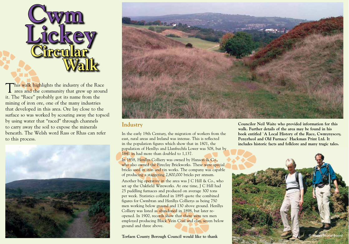
This walk highlights the industry of the Race area and the community that grew up around
it. The “Race” probably got its name from the mining of iron ore, one of the many industries that developed in this area. Ore lay close to the surface so was worked by scouring away the topsoil by using water that “raced” through channels to carry away the soil to expose the minerals beneath. The Welsh word Rass or Rhas can refer to this process.
Industry
In the early 19th Century, the migration of workers from the east, rural areas and Ireland was intense. This is reflected in the population figures which show that in 1801, the population of Henllys and Llanfrechfa Lower was 508, but by 1841 in had more than doubled to 1,137.
In 1858, Henllys Colliery was owned by Hanson & Co., who also owned the Fireclay Brickworks. These were special bricks used in iron and tin works. The company was capable of producing a staggering 2,800,000 bricks per annum.
Another big operative in the area was J C Hill & Co., who set up the Oakfield Wireworks. At one time, J C Hill had 25 puddling furnaces and produced on average 300 tons per week. Statistics collated in 1895 quote the combined figures for Cwmbran and Henllys Collierys as being 750 men working below ground and 130 above ground. Henllys Colliery was listed as abandoned in 1898, but later re-opened. In 1900, records show that there were ten men employed producing Black Vein Coal and clay, seven below ground and three above.
Torfaen County Borough Council would like to thank
Councilor Neil Waite who provided information for this walk. Further details of the area may be found in his book entitled `A Local History of the Race, Cwmynyscoy, Penyrheol and Old Furnace` Hackman Print Ltd. It includes historic facts and folklore and many tragic tales.
Lickey
CwmCircular
Walk
Lickey
Layout & Design by e-Graphics, Torfaen County Borough ©2006
Os hoffech gopi o’r ffurflen yn Gymraeg, cysylltwch a’r Gwasanaethau Cefn Gwlad Torfaen
^
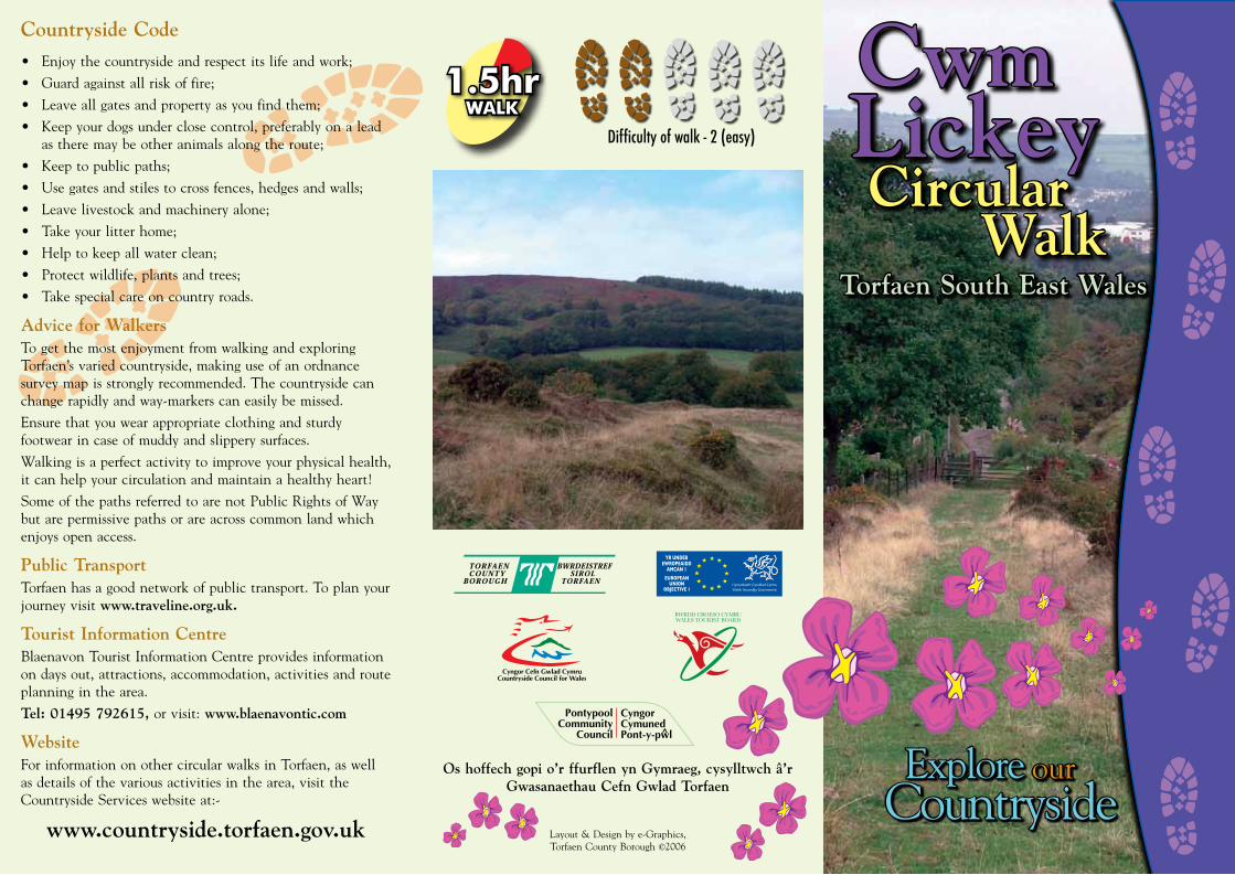
1.5hrWALK
Difficulty of walk - 2 (easy)
Countryside Code
• Enjoythecountrysideandrespectitslifeandwork;
• Guardagainstallriskoffire;
• Leaveallgatesandpropertyasyoufindthem;
• Keepyourdogsunderclosecontrol,preferablyonaleadastheremaybeotheranimalsalongtheroute;
• Keeptopublicpaths;
• Usegatesandstilestocrossfences,hedgesandwalls;
• Leavelivestockandmachineryalone;
• Takeyourlitterhome;
• Helptokeepallwaterclean;
• Protectwildlife,plantsandtrees;
• Takespecialcareoncountryroads.
Advice for WalkersTogetthemostenjoymentfromwalkingandexploringTorfaen’s varied countryside, making use of an ordnance survey map is strongly recommended. The countryside can change rapidly and way-markers can easily be missed.
Ensure that you wear appropriate clothing and sturdy footwear in case of muddy and slippery surfaces.
Walking is a perfect activity to improve your physical health, it can help your circulation and maintain a healthy heart!
SomeofthepathsreferredtoarenotPublicRightsofWaybut are permissive paths or are across common land which enjoysopenaccess.
Public TransportTorfaen has a good network of public transport. To plan your journeyvisitwww.traveline.org.uk.
Tourist Information CentreBlaenavon Tourist Information Centre provides information on days out, attractions, accommodation, activities and route planning in the area.
Tel: 01495 792615, or visit: www.blaenavontic.com
WebsiteFor information on other circular walks in Torfaen, as well as details of the various activities in the area, visit the Countryside Services website at:-
www.countryside.torfaen.gov.uk
© Wales Tourist Board
�
��
��
�
�
�� �
��
CwmCircular
WalkTorfaen South East Wales
ExploreourCountryside
This walk highlights the industry of the Race area and the community that grew up around
it. The “Race” probably got its name from the mining of iron ore, one of the many industries that developed in this area. Ore lay close to the surface so was worked by scouring away the topsoil by using water that “raced” through channels to carry away the soil to expose the minerals beneath. The Welsh word Rass or Rhas can refer to this process.
Industry
In the early 19th Century, the migration of workers from the east, rural areas and Ireland was intense. This is reflected in the population figures which show that in 1801, the population of Henllys and Llanfrechfa Lower was 508, but by 1841 in had more than doubled to 1,137.
In 1858, Henllys Colliery was owned by Hanson & Co., who also owned the Fireclay Brickworks. These were special bricks used in iron and tin works. The company was capable of producing a staggering 2,800,000 bricks per annum.
Another big operative in the area was J C Hill & Co., who set up the Oakfield Wireworks. At one time, J C Hill had 25 puddling furnaces and produced on average 300 tons per week. Statistics collated in 1895 quote the combined figures for Cwmbran and Henllys Collierys as being 750 men working below ground and 130 above ground. Henllys Colliery was listed as abandoned in 1898, but later re-opened. In 1900, records show that there were ten men employed producing Black Vein Coal and clay, seven below ground and three above.
Torfaen County Borough Council would like to thank
Councilor Neil Waite who provided information for this walk. Further details of the area may be found in his book entitled `A Local History of the Race, Cwmynyscoy, Penyrheol and Old Furnace` Hackman Print Ltd. It includes historic facts and folklore and many tragic tales.
Lickey
CwmCircular
Walk
Lickey
Layout & Design by e-Graphics, Torfaen County Borough ©2006
Os hoffech gopi o’r ffurflen yn Gymraeg, cysylltwch a’r Gwasanaethau Cefn Gwlad Torfaen
^
1.5hrWALK
Difficulty of walk - 2 (easy)
Countryside Code
•Enjoythecountrysideandrespectitslifeandwork;
•Guardagainstallriskoffire;
•Leaveallgatesandpropertyasyoufindthem;
•Keepyourdogsunderclosecontrol,preferablyonaleadastheremaybeotheranimalsalongtheroute;
•Keeptopublicpaths;
•Usegatesandstilestocrossfences,hedgesandwalls;
•Leavelivestockandmachineryalone;
•Takeyourlitterhome;
•Helptokeepallwaterclean;
•Protectwildlife,plantsandtrees;
•Takespecialcareoncountryroads.
Advice for WalkersTogetthemostenjoymentfromwalkingandexploringTorfaen’s varied countryside, making use of an ordnance survey map is strongly recommended. The countryside can change rapidly and way-markers can easily be missed.
Ensure that you wear appropriate clothing and sturdy footwear in case of muddy and slippery surfaces.
Walking is a perfect activity to improve your physical health, it can help your circulation and maintain a healthy heart!
SomeofthepathsreferredtoarenotPublicRightsofWaybut are permissive paths or are across common land which enjoysopenaccess.
Public TransportTorfaen has a good network of public transport. To plan your journeyvisitwww.traveline.org.uk.
Tourist Information CentreBlaenavon Tourist Information Centre provides information on days out, attractions, accommodation, activities and route planning in the area.
Tel: 01495 792615, or visit: www.blaenavontic.com
WebsiteFor information on other circular walks in Torfaen, as well as details of the various activities in the area, visit the Countryside Services website at:-
www.countryside.torfaen.gov.uk
© Wales Tourist Board
�
��
��
�
�
���
��
Nant
Dâr
DisusedShafts
Cwm LickeyPond
Line of Old Rifle Range
DisusedShafts Disused
ShaftsCollieryWaste
Old GorseLevel
StileBlaendareClay Level
TramwayStones
Old Tra
mroad
Old CoalLevels
Old CoalLevels
OldBrickworkSite
Old CoalLevels
BlaendareFarm
Area of OldMaunds Row
Blaendare FarmRoad
5 Houses
BusTurningArea
Area ofLong RowCottages
RaceHouse
Stile
Bridge
Stile
OldQuarries
Old LimeKilns
BinghamsRow
OldQuarry
PenyrheolReservoir Ra
ilings
Former Site of3rd Reservoir
Trevethin &Blaenavon
Llandegfedd Reservoir& Monmouthshire Hills
0 0.5 km
Views
Walk Route
Electricity Lines
Evidence ofScouring
Walk Start& Finish
CwmCircular
Walk
Lickey
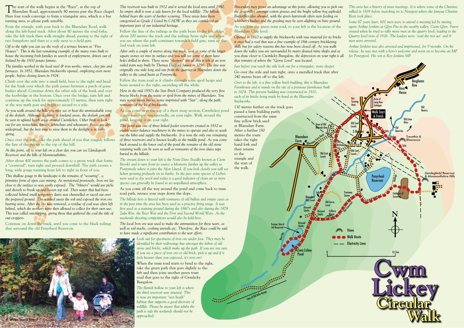
The start of the walk begins at the “Race”, at the top of Blaendare Road, approximately 80 metres past the Race chapel.
Here four roads converge to form a triangular area, which is a bus turning area, so please park sensibly.
From the triangle, with your back to the Blaendare Road, walk alongtheleft-handtrack.Afterabout80metrestheroadforks;take the left track then walk straight ahead, passing to the right of two bungalows and then to a stile next to a field gate.
Off to the right you can see the roofs of a terrace known as “Five Houses”. This is the last remaining example of the many rows built to house the incoming Irish families in search of employment, driven out of Ireland by the 1830 potato famine.
The families worked in the local steel & iron works, mines, clay pits and furnaces. In 1852, Blaendare brickworks opened, employing even more people, before closing down in 1924.
Climb over the stile into a small field, bear to the right and head for the bank over which the path passes between a patch of gorse bushes ahead. Continue down the other side of the bank and over the footbridge at the bottom. Once over the bridge, turn left and continue up the track for approximately 15 metres, then turn right at the way mark post and begin to ascend to a stile.
As you walk around the hills you may see or hear the unmistakable song of the skylark. Although declining in lowland areas, the skylark can still be seen in upland heath areas around Cwmlickey. Other birds to look out for are stonechats, linnets, whinchats and wheatears. Foxes are also widespread, but the best time to view them in the daylight is in early spring.
Once over the stile, take the path ahead of you that roughly follows the line of the pylons to the top of the hill.
At this point, off to your left on a clear day you can see Llandegveth Reservoir and the hills of Monmouthshire.
After about 400 metres the path comes to a green track that forms a “crossroad”, turn right and proceed downhill. The path crosses a long, wide gouge running from left to right in front of you.
This shallow gouge in the landscape is the remains of “scouring”, a primitive form of open cast mining. As mentioned previously, Iron ore lay close to the surface so was easily exposed. The “Miners” would use picks and shovels to break up and loosen top soil. Then water that had been collected behind small temporary dams was channelled or raced out over the prepared ground. This washed away the soil and exposed the iron ore bearing stone. After the ore was removed, a residue of coal was often left behind, which the workers were then allowed to collect for their own use. This was called outcropping, giving those that gathered the coal the title of out-croppers.
Continue on down the track, until you come to the black railings thatsurroundtheoldPenyrheolReservoir.
This reservoir was built in 1912 and it served the local area until 1980. Its empty shell is now a safe haven for the local wildlife. The hillside behind bears the scars of further scouring. These areas have been categorised as Grade 2 Listed by CADW as they are considered an important part of our industrial heritage.
Follow the line of the railings as the path bears to the left. After about 200 metres the track and the railings bears right and when you see where the path continues towards a field gate, turn up the 2nd track on your left.
After only a couple of metres along this track, look at some of the larger square stones set into its surface and you will see some of them have holes drilled in them. These stone “sleepers” are all that is left of an iron railed tram way built by Thomas Dadford Junior in 1796. The line was originally one mile long and ran from the quarries at Blaendare down the valley to the canal basin at Pontymoile.
Follow the tram road as it climbs through some spoil heaps and bears around to the right, ascending all the while.
Here in the mid 1950’s the Star Brick Company produced the very first breeze blocks from the waste or spoil from the mines of Blaendare. You may notice many bricks, some imprinted with “Star”, along the path; remnants of the local brickworks
As you come over the top of a short steep section, Cwmlickey pond comes into view, unexpectedly, on your right. Walk around the pond, keeping it on your right.
This pond was one of three linked feeder reservoirs created in 1832 to enable water balance machinery in the mines to operate and also to wash out the kilns and supply the brickworks. It is now the only one remaining of three reservoirs and is known locally as the middle pond. As you come back around to the lower end of the pond the remains of the old stone retaining walls can be seen as well as remnants of the iron sluice taps buried in the hillside.
The stream down to your left is the Nant Dare (locally known as Cwm Brook) and it runs from its source a kilometre further up the valley to Pontymoile where it joins the Afon Llwyd. If you look closely you will see lichen growing profusely on its banks. In the past some species of Lichen were used to dye wool and today is a good indicator of clean air as more species can generally be found in an unpolluted atmosphere.
As you come all the way around the pond and come back to tram road path, retrace your steps down the slope.
The hillside here is littered with remnants of old bullets and empty cases as in the past time the area has been used as a practice firing range. It was first used as a training ground during the 1860’s and also during the 1878 Zulu War, the Boer War and the First and Second World Wars. At the weekends shooting competitions would also be held here.
The local Iron ore was used to make the ammunition for these wars, as well as rail tracks, cooking utensils etc. Therefore, the Race could be said to have made a significant contribution to the war effort.
Look out for specimens of iron ore under foot. They may be identified by their red/orange hue amongst the debris of old stone and bricks, which make up the path. If you are not sure if you see a piece of iron ore or old brick, pick it up and if it feels heavier than you expected, it’s iron ore!
When the tram road starts to bend to the right, take the green path that goes slightly to the leftandthenjoinsanothergreentramroad that goes to the right of Cwmlicky Bungalow.
The flattish hollow to your left is where the third reservoir was situated. This is now an important “wet heath” habitat that supports a good diversity of wildlife. Please be aware that whilst the path is safe the wetlands should not be approached!
Binoculars may prove an advantage at this point, allowing you to pick out the dragonflies amongst cotton grasses and the bright yellow bog asphodel. Butterflies also abound, with the green hairstreak often seen feeding on whinberry bushes and the grayling may be seen alighting on bare ground.
Asyoujointhegreentramroad,toyourleftisthelocationoftheBlaendare Clay level.
Opened in 1810 to supply the brickworks with raw material for its bricks it once had a roof that was a fine example of 18th century bricklaying skills but for safety reasons this has now been closed off. As you walk down the valley you are surrounded by many disused mine shafts and as you draw closer to Cwmlicky Bungalow, the depression on your right is all that remains of where the “Gorse Level” was located.
Just before you reach the stile look out for a triangular, stone sleeper.
Go over the stile and turn right, onto a metalled track that after 240 metres bears off to the left.
Over to the left, is a fine yellow brick building; this is Blaendare Farmhouse and it stands on the site of a previous farmhouse built in 1674. This present building was constructed in 1810, each of its bricks being made by hand at the Blaendare brickworks.
130 metres further on the track goes passed a farm building partly constructed from the same fine yellow brick used at Blaendare Farm. After a further 180 metres the route takes the right hand fork and then returns to the triangle and the start of the walk.
This area has a history of mass meetings. It is where some of the Chartists rallied in 1839 before marching on to Newport where the famous Chartist Riots took place.
Some 87 years later, 600 men were to attend a meeting led by mining agent Arthur Jenkins at Glyn Pits in the nearby valley, Cwm Glyn. Furor ensued when he tried to rally more men at the quarry level, leading to the Quarry level riots of 1926. The leaders were `read the riot act` and 8 men were arrested.
Arthur Jenkins was also arrested and imprisoned, for 9 months. On his release, he was met with a hero’s welcome and went on to become an MP for Pontypool. His son is Roy Jenkins MP.
© Wales Tourist Board
N