lindsays gold mine- parrot feathers resource
TRANSCRIPT

1
Date: 20 July 2015 ASX Code: KGM www.kalnorthgoldmines.com Shares on issue: 315.97M ordinary shares Share Price: $0.009* Market Capitalization: $ 2.844 M* *the company applied Voluntary Suspension since 17 July 2015.
Projects Eastern Goldfields-Western Australia
• Kurnalpi (100%) • Lindsays (100%) • Kalpini (100%) • Spargoville (100%)
Directors Jiajun Hu: Chairman Lijun Yang: Executive Director & Company Secretary Yuanguang Yang: Non-executive Director Principal Office 224 Dugan Street Kalgoorlie, WA 6430 +61 8 9021 8327
Mailing Address PO Box 131 Subiaco ,WA 6904
LINDSAYS GOLD MINE-PARROT FEATHERS RESOURCE
KalNorth Gold Mines Limited (ASX:KGM) is pleased to advise that a updated resource estimate for the Parrot Feathers lode at the 100 percent owned Lindsays Gold Mine has been completed and will support a scoping study on underground development which is currently in progress.
JORC 2012 mineral resource estimate of 401,000tonnes at 4.2g/t Au for 54,000ounces of gold at the Parrot Feathers Lode.
Parrot Feathers lode occurs immediately beneath the stage 2 open pit and has been modelled to 130m below the pit floor.
Re logging of all previous drilling and incorporation of three recent diamond drill holes has provided an improved geological control to the mineralised structure.
Broad previous drill testing below 170m vertical depth from surface indicates continuity of the lode and scope for future evaluation
Initial scoping study to develop an underground mine based on the updated model in progress
Discussions with parties interested in tribute mine development continuing
KalNorths Executive Director Lijun Yang commented “The Lindsays Gold Mine was the inaugural exploration project and developed gold mine of KalNorth Gold Mines and the mining and processing in 2013 brought us an excellent opportunity to understand the details of the ore body and grade distribution. I believe the Parrot Feathers resource established below the stage 2 open pit will set up a good foundation for future underground mining”
Lindsays Stage 2 pit March 2015

2
Lindsays –Parrot Feathers Deposit
Open pit mine production at Lindsays by KalNorth commenced in January 2013 with development of three open pits, the largest being the Stage 2 Pit which hosts the Parrot Feathers lode. Mining ceased in August 5 2013 after the production of 138,229 tonnes of ore grading 1.93gpt which was hauled to and processed at Saracen Mineral Holdings Carosue Dam operation located some 75km to the east. The company elected to focus on re modelling the Parrot Feather lode as it was exposed at the base of the suspended stage 2 pit, contained higher grade intercepts from previous drilling than other zones at Lindsays and had exhibited down dip continuity to some 250m from surface. Furthermore the Stage 2 open pit provided a sound option from which to develop an underground mining operation. The Parrot Feathers lode resource was previously reported as part of the Eastern Structure (refer Fig 1&2) in the Lindsays Resource estimate (refer KGM ASX Annual report 2014). This resource update under JORC 2012refers to the Parrot Feathers mineralisation below the stage 2 open pit at the Lindsays Mine. The remainder of the Lindsays Project resource remains unchanged under the JORC Code (2004 edition) due to no material change having occurred.
Kalnorth engaged Ravensgate Mining Industry Consultants (“Ravensgate) to complete the mineral resource estimate to JORC 2012 standard. Ravensgate were familiar with the Lindsays project and style of mineralisation after completing a reconciliation assessment of the mining of the stage 2 open pit in 2014.
Geological Interpretation At Lindsays three main northwest trending gold mineralised structures trend through a folded sequence of basalt, dolerite and metasediments. The eastern structure (Figure1) is the most prominent and appears to occupy the axial plane of the south plunging fold, trends over some 1,100metres dipping shallowly to the south west at 45degrees (Figure4). This mineralised structure cross cuts lithological units with the more robust gold mineralisation hosted by dolerite at Parrot Feathers. The ore zone consists of one semi continuous quartz sulphide (pyrite and lesser chalcopyrite) vein (refer Figure 4&5) that has a strike length of approximately 250m all hosted within dolerite. The vein varies in thickness from 0.5m to up to 5m (true width) but is generally 1-2m wide and dips at a shallow angle (45o) to the south west. The ore zone is characterised by a limited or narrow (0.5m-2m) alteration selvage within the host dolerite adjacent to the vein. The vein and the mineralisation has down dip continuity with deeper wide spaced diamond drilling demonstrating continuity of the vein some 440m down dip from surface and is open at depth. To refine the geological model and support the Parrot Feathers estimate relogging of drill chips from archived chip trays from previous reverse circulation (RC) drill holes was commenced and completed during February-March 2015. This re interpretation based on the RC relogging ensured that the geology and logging was consistent throughout the deposit. The recent (refer KGM: ASX announcement 31 March 2015) diamond drill program was used to validate the geological interpretation and to determine if the orebody maintained the geometry from the base of the open pit. This drilling (refer Figure 3) confirmed

3
and validated the main Parrot Feathers lode and other subsidiary spur lodes by confirming the grade, continuity, vein thickness and interpreted dip-strike of mineralisation at Parrot Feathers. Resource Estimation Summary Full details on the methodology and parameters used for the mineral resource estimate are shown in the attached JORC 2012 Table 1, sections 1-3 and are summarised as follows. All the drilling data used in the resource estimate has been by the RC, diamond drill technique with a total of 96,295m drilled (92060m RC, 4234m Diamond) drilled over the period 2002 to 2015. All drilling was supervised by Kalnorth. The drill spacing is a nominal 20m by 20m with more promising areas infilled to higher densities. The density of the diamond drilling is far more dilute than the RC data, the diamond holes were positioned at much wider spacings (Figure6). The majority of the holes have been orientated at 60o to 90o to intersect the 45 degree flat dipping lode at the optimum angle. The mineralised envelopes for the Parrot Feathers deposit were based on a 0.5gt Au threshold using a maximum of 2m (2 samples) of internal dilution and constructed by Ravensgate. Wireframes were constructed in three dimensions using Surpactm software. A 1.0gt Au high grade internal wireframe using a maximum of 1m (1sample) of internal dilution was prepared by Kalnorth and provided to Ravensgate. A top cut of 18gt Au was applied to all the mineralised lodes and 0.5gt Au was applied outside of the mineralised lodes to limit any >0.5gt Au single hits in the waste. Ravensgate carefully reviewed and considered the local deposit statistics of the Parrot Feathers deposit and decided that ordinary Kriging (OK) interpolation technique would be used in the block model interpolation. The components were estimated using OK into parent cells with a cell discretization of 3 north by 3 east by 5 elevation (XYZ). The mineralised envelopes were treated as hard boundaries for estimation. Model validation was carried out graphically and statistically to ensure that the block model grades accurately represent the input drill hole data. Cross sections were viewed on screen in Surpactm to validate the block estimation against the drill hole composites The bulk density values and associated weathering wireframes (BOCO-base of complete oxidation, and TOFR-top of fresh rock) were prepared and provided by KalNorth. The values range from 2.20 t/m3 for oxide to 2.80t/m3 in fresh rock. Resource classification (measured-indicated-inferred) at Parrot Feathers was based upon a number of quality parameters (eg drill density). Approximately 26% of the inferred material at Parrot Feathers has been extrapolated. Any mineralisation below the 230mRL (not wireframed) was considered by Ravensgate to be an exploration target (unclassified-not reported) and was not reported in the Resource. The resource model has been reported at a lower cut off of 3.0g/t Au (Table 1) and depicted on a longitudinal section on Figure 7. This relatively high cut off was applied by Ravensgate because future mining of the Parrot Feathers lode is likely to be by underground mining methods from the base of the stage 2 open pit. The resource update under JORC 2012 and the resource report completed by Ravensgate only refers to the Parrot Feathers mineralisation part of the Lindsays project area. The

4
remainder of the Lindsays Project resource remains unchanged under the JORC code 2004. The limits of the Parrot Feathers deposit were previously reported within the Eastern Structure resource envelope. The extent of the current Parrot Feathers lode has been removed from the Eastern Structure and this is reflected in Table 2.
Table 1 Lindsays- Parrot Feathers Deposit 2015 Resource Estimate at 3.0g/t Au Lower Cut. Material Tonnes (t) Grade (g/t) Ounces (oz) Indicated 140,000 4.0 18,000 Inferred 261,000 4.3 36,000
Total 401,000 4.2 54,000 Table 2 Lindsays Project Resource Estimate –JORC 2004
Note –Table 2 was reported in the Company’s 2013 and 2014 Annual Reports under JORC 2004 compliance. All deposits were modelled using a 0.3g/t Au wireframe and reported at a grade cutoff of 0.5g/t Au. There has been no material change to the mineral resource estimate at each of the four deposits since prepared and reported under JORC 2004.
Future Work The Lindsays Gold mine was placed under suspension in August 2013 but all the required regulatory approvals and permitting and infrastructure are in place to recommence mining. The more robust geological model and improved grade distribution within the Parrot Feathers lode gives further confidence to KalNorth to consider underground development from the base of the stage 2 open pit The company has commenced and is well advanced with an initial scoping study and preliminary economic evaluation to develop the Parrot Feathers lode via underground mining. The company continues to progress negotiations with parties interested in a tribute type of mining development of the Parrot Feathers lode.
Lijun Yang Executive Director KalNorth Gold Mines Limited
Deposit Tonnes (t) Grade (g/t) Ounces (oz) Tonnes (t) Grade (g/t) Ounces (oz) Tonnes (t) Grade (g/t) Ounces (oz) Tonnes (t) Grade (g/t) Ounces (oz)Eastern Structure (1) - - - 1,479,000 1.60 76,000 203,000 1.6 10,500 1,682,000 1.60 86,500Central Structure (1) - - - 1,315,100 1.10 46,500 47,900 1.1 1,700 1,363,000 1.10 48,200Neves Prospect (1) - - - 490,900 1.60 24,900 37,700 1.3 1,500 528,600 1.55 26,400
Stockpile(7) 64,100 0.87 1800 - - - - - - 64,100 0.87 1,800Total 64,100 0.87 1800 3,285,000 1.40 147,400 288,600 1.5 13,700 3,637,700 1.4 162,900
LINDSAYS PROJECT RESOURCE SUMMARY-JORC 2004Measured Indicated Inferred Total

5
Figure 1-Lindsays Gold Mine showing site plan, tenements and Stage 2 pit

6
Figure 2-Inset Map showing stage 2 pit, extent of Parrot Feathers and site of diamond drill holes completed in March 2015.
Figure 3 Cross Section 48450N showing recent drill hole LIND 007 beneath Stage 2 pit

7
Figure 4-Stage 2 pit at the Lindsays Project showing the local geology (Base of Pit is 360mRL, Surface 404mRL). Source: Mineral Resource Estimate Report-Parrot Feathers 2015-Ravensgate
Figure5 Close up of remnants of the ore in the west and North west wall of the Lindsays Stage 2 pit ( look approximately 330o) showing gold variability in the quartz vein ( Parrot Feathers Lode) and channel sampling (B)- Source: Mineral Resource Estimate Report 2015-Parrot Feathers-Ravensgate

8
Figure 6 Plan view of drill holes located at Stage 2 pit and used to compile Parrot Feathers resource
Figure 7 Longitudinal section of the Parrot Feathers lode showing distribution of resource block grades
9
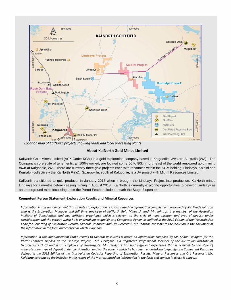
KALNORTH GOLD FIELD
Location map of KalNorth projects showing roads and local processing plants
About KalNorth Gold Mines Limited KalNorth Gold Mines Limited (ASX Code: KGM) is a gold exploration company based in Kalgoorlie, Western Australia (WA). The Company’s core suite of tenements, all 100% owned, are located some 50 to 80km north-east of the world renowned gold mining town of Kalgoorlie, WA. There are currently three gold projects each with resources within the KGM holding: Lindsays, Kalpini and Kurnalpi (collectively the KalNorth Field). Spargoville, south of Kalgoorlie, is a JV project with Mithril Resources Limited.
KalNorth transitioned to gold producer in January 2013 when it brought the Lindsays Project into production. KalNorth mined Lindsays for 7 months before ceasing mining in August 2013. KalNorth is currently exploring opportunities to develop Lindsays as an underground mine focussing upon the Parrot Feathers lode beneath the Stage 2 open pit.
Competent Person Statement-Exploration Results and Mineral Resources
Information in this announcement that’s relates to exploration results is based on information compiled and reviewed by Mr. Wade Johnson who is the Exploration Manager and full time employee of KalNorth Gold Mines Limited. Mr. Johnson is a member of the Australian Institute of Geoscientists and has sufficient experience which is relevant to the style of mineralisation and type of deposit under consideration and the activity which he is undertaking to qualify as a Competent Person as defined in the 2012 Edition of the “Australasian Code for Reporting of Exploration Results, Mineral Resources and Ore Reserves”. Mr. Johnson consents to the inclusion in the document of the information in the form and context in which it appears Information in this announcement that’s relates to Mineral Resources is based on information compiled by Mr. Shane Fieldgate for the Parrot Feathers Deposit at the Lindsays Project. Mr. Fieldgate is a Registered Professional Member of the Australian Institute of Geoscientists (AIG) and is an employee of Ravensgate. Mr. Fieldgate has had sufficient experience that is relevant to the style of mineralisation, type of deposit under consideration and to the activity which he has been undertaking to qualify as a Competent Person as defined in the 2012 Edition of the “Australasian Code for Reporting of Exploration Results, Mineral Resources and Ore Reserves”. Mr. Fieldgate consents to the inclusion in the report of the matters based on information in the form and context in which it appears

10
JORC Code 2012 Edition – Table 1
Section 1 Sampling Techniques and Data (Criteria in this section apply to all succeeding sections.)
Criteria Explanation Comment
Sampling techniques
Nature and quality of sampling.
The deposit was sampled using Reverse Circulation (RC) and Diamond (DDH) drill holes on nominal 20m x 20m spacing and RC collar with diamond tails (RD) on a nominal 120m x 120m grid spacing. A total of 1,155RC (88,161m), 8 DDH (1,998.7m) and 36 RD (3,900m RC and 3899.9m DDH).
All drill holes were drilled to optimally intercept the mineralised zones. No other sampling techniques were employed.
Sampling quality is discussed in subsequent sections of Table 1.
Include reference to measures taken to ensure sample representivity and the appropriate calibration of any measurement tools or systems used.
Drill hole collars were picked up by survey contractors and equipment calibrated using several existing state survey control points. RC drilling methods were used with samples collected by cone or riffle splitter and analysed at NATA accredited laboratories. Triple tube DD drilling was used for high quality core samples. Sampling was carried out under KalNorth Gold Mine Limited (KalNorth) protocols and QAQC procedures as per industry best practice.
Aspects of the determination of mineralisation that are Material to the Public Report.
All material aspects are described in various sub-sections below.
Drilling techniques Drill type (eg core, reverse circulation, open-hole hammer, rotary air blast, auger, Bangka, sonic, etc) and details (eg core diameter, triple or standard tube, depth of diamond tails, face-sampling bit or other type, whether core is oriented and if so, by what method, etc).
RC, DDH and RD drill hole accounts for 96% of the resource estimate. The diamond drilling accounts for 4% of the total drill metres.
Historic drilling (41 holes) undertaken in 1980’s by AUR NL – it is unsure the type of drilling used (RC or open percussion) and where not used in the resource estimate.
Pre 2015 (Carrick and KalNorth) – Similar equipment was used for 2015 program (see below)
2015 KalNorth RD program (both RC and DDH) were undertaken by Ragen Drilling using a custom built Reverse Circulation drill rig mounted on a 6 x 6 truck. Specifications of the rig are hole diameter 4¾” (120mm), Sullair 1150cfm x 350psi compressor, cyclone mounted on swinging arm and a Hurricane 636-41B 1400 cfm x 700psi booster which was not generally required.
Drill sample recovery
Method of recording and assessing core and chip sample recoveries and results assessed.
Aur NL – recoveries are unknown
Carrick and KalNorth – RC - Sample weights of the bags were checked in the field by the logging geologist and light samples which might indicate core loss were noted in the log. All drilling was dry, above the water table. Consistent sample bag weights were obtained for the vast majority of RC samples.
Carrick and KalNorth – Diamond - Core recoveries were ≥98% with no core loss issues; triple tube used.
All results for the Carrick and KalNorth are written to the database.
Measures taken to maximise sample recovery and ensure representative nature of the samples.
Depths are checked against the depth given on the core blocks and rod count is routinely carried out by the drillers. RC samples were visually checked for recovery, moisture and contamination.
Whether a relationship exists between sample recovery and grade and whether sample bias may have occurred due to preferential loss/gain of fine/coarse material.
The resource is defined by RC and DDH drilling, which had high recoveries. The style of mineralisation and the consistency of the mineralised intervals are considered to preclude any issue of sample bias due to material loss or gain.
Logging
Whether core and chip samples have been geologically and geotechnically logged to a level of detail to support appropriate Mineral Resource estimation, mining studies and metallurgical studies.
A geologist was logging at the rig for all RC drilling with quality digital geological logs produced and loaded in a database along with survey, assay and QAQC data. Chip tray samples were collected. DDH logs included lithological, structural, recovery, geotechnical (RDQ, number of fractures and weathering). Geotechnical logs were completed on the all diamond programs.
Whether logging is qualitative or quantitative in nature. Core (or costean, channel, etc)
Logging of the RC or diamond samples recorded lithology, structure, mineralisation, colour and other features of the sample. Core was photographed in wet and dry form.
11
Criteria Explanation Comment
photography.
The total length and percentage of the relevant intersections logged.
All drill holes were logged in full.
Re-logging of the RC (from chip trays) drill holes around the main lode was completed in 2015 within 30m either side of the mineralised zone
Sub-sampling techniques and
sample preparation
If core, whether cut or sawn and whether quarter, half or all core taken.
The core cut in half using a diamond blade saw and half was sent to the laboratory for analysis.
If non-core, whether riffled, tube sampled, rotary split, etc and whether sampled wet or dry.
RC samples were collected on the rig using 1:8 riffle splitter. All samples within the mineralised zones were dry.
For all sample types, the nature, quality and appropriateness of the sample preparation technique.
AUR NL – unknown, due to no documentation.
Carrick and KalNorth - used NATA accredited commercial laboratories (KalAssay and Genalysis in both Perth and Kalgoorlie) where sample preparation follows industry best practice sample preparation involving oven drying, followed by a automated coarse crushing of the samples followed by pulverising of the entire sample grinding size of 90% passing 160 micron.
The sample preparation for the diamond is identical.
Quality control procedures adopted for all sub-sampling stages to maximise representivity of samples.
AUR NL – No documentation available.
Carrick and KalNorth - Field QC procedures involve the use of certified reference material (CRM) as assay standards, along with field duplicates at a insertion rate of these average 1:20 for both CRM and duplicates (alternating between mid-way between CRMs).
Measures taken to ensure that the sampling is representative of the in situ material collected, including for instance results for field duplicate/second-half sampling.
Field duplicates were taken on 1m composites for RC using a riffle splitter. The 2015 RD program where used to verify the grade, geometry, strike and dip of the main lode. All drill holes supported the location of the geological intervals intersected in the RC drill holes (DDH cores were sampled at 1m intervals and on geological contacts).
Whether sample sizes are appropriate to the grain size of the material being sampled.
The sample sizes are considered to be appropriate to correctly represent the mineralisation at the Lindsay’s Project, given the thickness and consistency of the intersections, the sampling methodology and high precent value ranges for the primary element of interest.
Quality of assay data and
laboratory tests
The nature, quality and appropriateness of the assaying and laboratory procedures used and whether the technique is considered partial or total.
KalNorth used NATA accredited commercial laboratories (KalAssay and Genalysis) which follow industry best practice. Au were analysed by Fire Assays. No documentation was available on AUR NL drill holes.
For geophysical tools, spectrometers, handheld XRF instruments, etc, the parameters used in determining the analysis including instrument make and model, reading times, calibrations factors applied and their derivation, etc.
No geophysical tools were used to determine any element concentrations used in this resource estimate.
Nature of quality control procedures adopted (eg standards, blanks, duplicates, external laboratory checks) and whether acceptable levels of accuracy (ie lack of bias) and precision have been established.
At KalAssay and Genalysis Laboratory, internal laboratory CRM were inserted every 20th sample and at the start and end of the batch. Both KalAssay and Genalysis Laboratory engage in the CSIRO round robin SG9 checks every 2 months.
Independent umpire laboratory check campaigns have been carried out 58 samples. The drilling campaigns show good precision.
Field duplicates and CRMs for Au samples revels that precision of samples is within acceptable limits for the Carrick and KalNorth drilling campaigns. The majority of the CRM (inserted every 20th sample were within acceptable limits and the majority of the field duplicates (inserted every 0th sample number) were ≥90% of its with difference (half pairs absolute relative difference or HARD).
Verification of sampling and
The verification of significant intersections by independent or alternative company personnel.
Ravensgate consultant geologists have visually verified significant intersections in the RC and diamond as part of the resource estimation process.
The 2015 RD program holes were used to verify the grade, geometry, strike and dip of the main lode. All drill
12
Criteria Explanation Comment
assaying holes supported the location of the geological intervals intersected in the previous drill holes.
The use of twinned holes. No twinned drill hole have been used.
Documentation of primary data, data entry procedures, data verification, data storage (physical and electronic) protocols.
Primary data was collected using paper logs. The logs were then transferred into Excel spread sheet and checked. Ravensgate transferred the MS Excel spread sheets into MS Access database. No checks by Ravensgate were completed to ensure the data was correctly entered.
Discuss any adjustment to assay data. No adjustments or calibrations were made to any assay data used in this estimate.
Location of data points
Accuracy and quality of surveys used to locate drill holes (collar and down-hole surveys), trenches, mine workings and other locations used in Mineral Resource estimation.
The collars of the Carrick and KalNorth drill holes where surveyed by Timble R6, base receiver and rover equipment using the Real Time Kimematic method (RTK). The equipment was calibrated using several existing state survey control points. The excepted accuracy for the RTK method are ±0.03m in the horizontal and ±0.05m in the vertical relative to the survey control used. The early RC drill holes (“PFRC”) only have a planned downhole survey. KalNorth re-entered all the drill hole that the company could find and resurveyed the drill hole with a gyro downhole camera. The remaining drill hole (KalNorth didn’t find) still has a planned downhole survey. These PFRC drill holes represent 13% of the RC drill holes. Ravensgate checked the collar position RLs against the original topographic surface. No adjustments were required.
The mine workings (2002 open pit) was surveyed using the same equipment as described as above by KalNorth surveyors.
Specification of the grid system used. The grid system is Lindsay’s Local Mine Grid.
Quality and adequacy of topographic control. Topographic surface was picked up by the onsite surveys on a 5m x 5m grid.
Data spacing and distribution
Data spacing for reporting of Exploration Results. A variety of drill spacings is present across the resource areas. Initial drilling was on a series of broad traversals across the deposit, nominally 40m x 40m, with more promising areas and pit area infilled to higher densities.
Whether the data spacing and distribution is sufficient to establish the degree of geological and grade continuity appropriate for the Mineral Resource and Ore Reserve estimation procedure(s) and classifications applied.
Over most of the deposits the spacing has been closed down to 40m (north) x 40m (east). Spacing has been further closed down to 8m (north) x 4m (east) in the Parrot Feathers lode. The mineralised domains have demonstrated sufficient continuity in both geological and grade continuity to support the definition of Mineral Resource and the classification applied under the 2012 JORC Code.
Whether sample compositing has been applied. Samples have been composited to 1m metre length. Over 87% of the sampling was sampled at 1m intervals. No residual composites were produced.
Orientation of data in relation to
geological structure
Whether the orientation of sampling achieves unbiased sampling of possible structures and the extent to which this is known, considering the deposit type.
All drill holes have been orientated to intersect the ore zone optimally, although this wasn’t always possible. This has resulted in the direction of maximum variation in grades having the closer spaced sampling interval of 2m down hole. Ravensgate consider the orientation of data to have been optimised in relationship to geological structure.
If the relationship between the drilling orientation and the orientation of key mineralised structures is considered to have introduced a sampling bias, this should be assessed and reported if material.
No orientation based sampling bias has been identified in the data at this point.
Sample security The measures taken to ensure sample security.
Samples were stored on site until KalNorth transferred the samples to Kalgoorlie where KalNorth personnel loaded the samples in the back of the utes and transported them directly to the Laboratory.
Audits or reviews
The results of any audits or reviews of sampling techniques and data.
A review of the sampling techniques and the data was carried out by an independent consultancy (Ravensgate) as part of the resource estimate which concluded that the database is considered of sufficient quality to carry out resource estimation.
Resource modelling was carried out by an independent consultancy (Ravensgate) which included a peer review by a second geologist. No other reviews or audits have been conducted.
13
Section 2 Reporting of Exploration Results (Criteria listed in the preceding section also apply to this section.)
Criteria Explanation Comment
Mineral tenement and land tenure
status
Type, reference name/number, location and ownership including agreements or material issues with third parties such as joint ventures, partnerships, overriding royalties, native title interests, historical sites, wilderness or national park and environmental settings.
The mining lease M27/169 is listed in Tengraph as owned by KalNorth. Ravensgate takes no responsibility for confirming the accuracy or validity the tenements, which is a matter for appropriate experts in tenement law.
The security of the tenure held at the time of reporting along with any known impediments to obtaining a licence to operate in the area.
There are no impediments to obtaining a licence to operate in the area known to Ravensgate. There are significant mining operations on gold deposits in the same rock formation as Lindsay’s nearby in the Kalgoorlie district.
Exploration done by other parties
Acknowledgment and appraisal of exploration by other parties.
Exploration was commenced by AUR NL in the 1980s. Carrick obtained the Lindsay’s tenements around 2002 and changed its name to KalNorth in 2012.
Geology Deposit type, geological setting and style of mineralisation.
The Parrot Feathers deposit is a typical Eastern Goldfield shear/faulted hosted narrow vein gold deposit. The Lindsay’s Field lies in the Archaean Kalgoorlie Terrane within the Eastern Goldfields Province of the Yilgarn Craton. It covers broadly northwest trending folded and deformed sequence of predominantly basalt and dolerite with intercalated metasedimentary units comprising black shale, arkosic sandstone and pebbly grits which is intruded by granodiorite.
Drill hole Information
A summary of all information material to the understanding of the exploration results including a tabulation of the following information for all Material drill holes:
The deposit were sampled using RC and DDH drill holes on nominal ??? spacings and RC collar with diamond tails (RD) on a nominal 20m x 120m grid spacing. A total of 1,155RC (88,161m), 8 DDH (1,998.7m) and 36 RD (3,900m RC and 3899.9m DDH). Only the AUR NL drill holes have been excluded from the estimation of a Mineral Resource. Detailed tabulation of every drill hole is not required in the public release, but has been presented in an appendix to the underlying detailed report prepared by Ravensgate.
Data aggregation methods
In reporting Exploration Results, weighting averaging techniques, maximum and/or minimum grade truncations (eg cutting of high grades) and cut-off grades are usually Material and should be stated.
Not applicable because a Mineral Resource was reported in 2011 and 2015.
The assumptions used for any reporting of metal equivalent values should be clearly stated.
No assumptions have been used for the reporting of metal equivalents as no of metal equivalents values have been used.
Relationship between
mineralisation widths and
intercept lengths
These relationships are particularly important in the reporting of Exploration Results.
Not applicable because a Mineral Resource was reported in 2011 and 2015.
If the geometry of the mineralisation with respect to the drill hole angle is known, its nature should be reported.
The mineralisation at Parrot Feathers dips 45° to the horizontal. Most of drill holes were drilled at 60° or vertical (most of the early drill holes). All care has been taken to intercept the ore at optimal angle.
If it is not known and only the down hole lengths are reported, there should be a clear statement to this effect (eg ‘down hole length, true width not known’).
Apparent width is stated.
Diagrams
Appropriate maps and sections (with scales) and tabulations of intercepts should be included for any significant discovery being reported These should include, but not be limited to a plan view of drill hole collar locations and appropriate sectional views.
Appropriate maps and sections have been provided.
Balanced reporting
Where comprehensive reporting of all Exploration Results is not practicable, representative reporting of both low and high grades and/or widths should be practiced to avoid misleading reporting of Exploration Results.
Not applicable because a Mineral Resource is being reported.

14
Criteria Explanation Comment
Other substantive exploration data
Other exploration data, if meaningful and material, should be reported including (but not limited to): geological observations; geophysical survey results; geochemical survey results; bulk samples – size and method of treatment; metallurgical test results; bulk density, groundwater, geotechnical and rock characteristics; potential deleterious or contaminating substances.
Refer to Section 3 of this table.
Further Work
The nature and scale of planned further work (eg tests for lateral extensions or depth extensions or large-scale step-out drilling).
A prefeasibility study to mine the ore body using underground methods is planned to be undertaken in the future which is incorporating mining, metallurgy and environmental studies.
Diagrams clearly highlighting the areas of possible extensions, including the main geological interpretations and future drilling areas, provided this information is not commercially sensitive.
There are possible extensions down dip at Parrot Feathers deposit.

15
Section 3 Estimation and Reporting of Mineral Resources (Criteria listed in Section 1, and where relevant in Section 2, also apply to this section.)
Criteria Explanation Comment
Database integrity
Measures taken to ensure that data has not been corrupted by, for example, transcription or keying errors, between its initial collection and its use for Mineral Resource estimation purposes.
Data collected was directly input into computers in field by KalNorth personnel. Data was received from the laboratory as electronic files. Data transfer was electronic via email or USB. Sample numbers were unique and pre-numbered bags were used. The data was transferred into a MS Access database where Ravensgate combined the data into a single database. These methods minimise the potential of errors.
Data validation procedures used. Ravensgate completed a check of the database for missing coordinates, duplicate assay, collar, geology and survey intervals, duplicated drill holes and missing assays and surveys. A visual validation was undertaken by displaying the data in 3 dimensions on computer screen using geological modelling software.
Site visits Comment on any site visits undertaken by the Competent Person and the outcome of those visits.
Ravensgate carried out a site visit to the Parrot Feathers deposit on the 25th March 2015 while KalNorth was drilling at Kalpini. Mr Shane Fieldgate (Resource Consultant Geologist with Ravensgate), who is the Competent Person, inspected the project area, outcrops, diamond drilling operations, sampling operations and the drill sites. During this time, notes and photos were taken and discussions were held with site personnel regarding the geology and field procedures. The 2015 diamond core was viewed at KalNorth Kalgoorlie office. Photos of the diamond core were provided to Ravensgate. A number of minor recommendations were made on procedures but no major issues were encountered.
If no site visits have been undertaken indicate why this is the case.
A site visit was undertaken.
Geological interpretation
Confidence in (or conversely, the uncertainty of) the geological interpretation of the mineral deposit.
The confidence in the geological interpretation is good. The Parrot Feathers deposit is a typical Eastern Goldfield shear/faulted hosted narrow vein gold deposit. The Lindsay’s Field lies in the Archaean Kalgoorlie Terrane within the Eastern Goldfields Province of the Yilgarn Craton. It covers broadly northwest trending folded and deformed sequence of predominantly basalt and dolerite with intercalated metasedimentary units comprising black shale, arkosic sandstone and pebbly grits which is intruded by granodiorite.
The 2015 RD program was used to confirm and validate the main lode and another minor lodes by confirming the grade, continuity, interpretation dip and strike of the mineralisation at the Parrot Feathers deposit.
Nature of the data used and of any assumptions made. Data mainly comprises geological logging and geochemical analysis of drill chips and drill core. No assumptions on the data have been made.
The effect, if any, of alternative estimation interpretations on Mineral Resource estimation
The deposit is tabular in geometry, with distinct boundaries defining the mineralised domains.
The use of geology in guiding and controlling Mineral Resource estimation.
The mineralised envelopes for Lindsays were based on drill intercepts of ≥0.50g/t Au using maximum of 2m (2 samples) internal dilution. The logged quartz percentage was used as a guide for the wireframes. The mineralised zone wireframes were extrapolated to the edges of the drilling along and perpendicular to the strike to maintain geological consistency. Mapping and grade control drilling from the 2002 open pit was also used as a guide.
The factors affecting continuity both of grade and geology.
All mineralised envelopes where cut against a northern fault that had been mapped in the pit. The fault was extrapolated along strike from the average readings from the mapping.
Dimensions
The extent and variability of the Mineral Resource expressed as length (along strike or otherwise), plan width, and depth below surface to the upper and lower limits of the Mineral Resource.
Parrot Feathers Lode - 345m (along strike) by 45m (perpendicular to the strike) by 205m in depth (maximum)
Estimation and modelling techniques
The nature and appropriateness of the estimation technique(s) applied and key assumptions, including treatment of extreme grade values, domaining, interpolation parameters and maximum distance of extrapolation from data points. If a computer assisted estimation method was chosen include a description of computer software and parameters used.
Grade estimation using ordinary kriging was completed for one reportable element – Au (g/t). Drill hole sample data was flagged using domain codes generated from 3D mineralisation domains and geological surfaces. Sample data was composited per element to a 1m down-hole length. There were no residual composites. Intervals with no assay were excluded from the compositing routine. The influence of extreme grade values were examined utilising top cutting analyst tools (grade histograms; log probably plots and coefficients of variation). A 0.50g/t Au cut-off was used to interpret wireframes of mineralisation.
Grade continuity was measured using geostatistical techniques. Directional variograms were modelled using traditional and normal score transformation variograms.

16
Criteria Explanation Comment
The availability of check estimates, previous estimates and/or mine production records and whether the Mineral Resource estimate takes appropriate account of such data.
Check against a previous resource (2011) and actual mining figures where made within the existing Parrot Feathers pit.
The assumptions made regarding recovery of by-products.
It is not anticipated that by-products could be produced and no assumptions were made of by-products.
Estimation of deleterious elements or other non-grade variables of economic significance (eg sulphur for acid mine drainage characterisation).
No other elements or non-grade variables were estimated.
In the case of block model interpolation, the block size in relation to the average sample spacing and the search employed.
A kriging neighbourhood analyst (KNA) was completed in order to optimise the block size and number of samples used. The following parameters were adopted based on this analysis: a parent block size of 2.5mN x 2.5mE x 2.5mRL and minimum and maximum number of samples of 8 and 20; sub-blocking of 0.675mN x 0.675mE x 0.675mRL and discretisation of 3m by 3m by 5m(XYZ) for all domains.
Four search passes were used for interpolation of grade into the blocks of each domain. The first pass was constrained to the search ellipsoid using a minimum of 8 and a maximum of 20 samples. Second pass - minimum number of samples was halved to 4. The third pass - the search ellipsoid was doubled. Fourth pass - minimum number of samples reduced to 2. Any un-estimated blocks were assigned the mean grade for their domain and the lowest resource confidence classification. Hard boundaries were applied between all estimated domains.
Any assumptions behind modelling of selective mining units.
No selective mining units were assumed in this estimate.
Any assumptions about correlation between variables. No correlation between any units.
Description of how the geological interpretation was used to control the resource estimates.
Refer to Estimation and Modelling Techniques section above. A top cut of 16g/t was applied to all mineralised wireframes
Discussion of basis for using or not using grade cutting or capping.
The influence of extreme grade values were examined utilising top cutting analyst tools (grade histograms; log probably plots and coefficients of variation).
The process of validation, the checking process used, the comparison of model data to drill hole data, and use of reconciliation data if available.
Model validation was carried out graphically and statistically to ensure that the block model grades accurately represent the input drill hole data. A number of methods were employed to validate the block model including: global mean comparison; visual comparison; trend plot comparison. The global mean comparison between drill composite grades and model grades within each of the mineralised zone wireframes shows that, globally, the estimates validate well within all well informed domains for both deposits. Cross sections were viewed on-screen and showed a good comparison between the drill hole data and the block model grades. A volume comparison between the volume of the block model cells within each mineralised zone and the volume of the corresponding wireframe. The results were in acceptable limits.
An independent reconciliation was written by Fieldgate 2014. Reconciliation was poor during mining due to inappropriate MP3 block modelling software being used for grade control, which resulted in the tonnes being over estimated and high grade being smeared over areas that weren’t mineralised. As a result the grade of the mined material was heavily diluted by waste. It is believed that this was caused by the MP3 block model being unconstrained and because no top cut was applied to the grades.
Moisture
Whether the tonnages are estimated on a dry basis or with natural moisture, and the method of determination of the moisture content.
The tonnages are estimated on a dry basis.
Cut-off parameters
The basis of the adopted cut-off grade(s) or quality parameters applied.
A nominal cut-off of 0.50g/t Au was used to define the mineralised envelope, based on a change of population on a probability plot.
Mining factors or assumptions
Assumptions made regarding possible mining methods, minimum mining dimensions and internal (or, if applicable, external) mining dilution.
Mining of the Parrot Feathers deposit is anticipated to be by underground pit mining methods involving mechanised mining techniques. The similar geometry and rock types are likely to make them amenable to mining methods currently employed in operations on similar deposits in the area. No other assumptions on mining methodology have been made.

17
Criteria Explanation Comment
Metallurgical factors or
assumptions The basis for assumptions or predictions regarding metallurgical amenability.
The similar geometry and rock types are likely to make them amenable to mining methods currently employed in operations on similar deposits in the area. The Parrot Feathers pit was processed at a neighbouring CIL gold plant. It is assumed that a similar plant will be used for the processing of the underground material.
No other assumptions on mining methodology have been made.
Environmental factors or
assumptions
Assumptions made regarding possible waste and process residue disposal options.
It has been assumed that there are no environmental factors which would prevent the eventual economic extraction of these deposits. Environmental surveys and assessments will form a part of a prefeasibility study.
Bulk density Whether assumed or determined. If assumed, the basis for the assumptions. If determined, the method used, whether wet or dry, the frequency of the measurements, the nature, size and representativeness of the samples.
Bulk density was supplied by KalNorth.
This average bulk densities (t2/m) was applied to all the block model cells within the appropriate zone:
Oxide – 2.20;
Transitional – 2.62
Fresh – 2.80
The bulk density for bulk material must have been measured by methods that adequately account for void spaces (vugs, porosity, etc), moisture and differences between rock and alteration zones within the deposit.
Bulk density has been measured by techniques that would adequately account for void space - coating the rock in wax to cover the pore spaces; then weighting the waxed rock in air and weighting again suspended in water. The difference between the use of wax to seal the core and the not using wax was approximately 3%.
Discuss assumptions for bulk density estimates used in the evaluation process of the different materials.
Only one lithological unit occurs with the mineralisation (dolerite). No other unit intersected the mineralisation.
Classification
The basis for the classification of the Mineral Resources into varying confidence categories.
Estimation parameters including kriging variance, pass number, number of samples informing the block cell and drill spacing were considered during the classification process.
Whether appropriate account has been taken of all relevant factors (ie relative confidence in tonnage/grade estimations, reliability of input data, confidence in continuity of geology and metal values, quality, quantity and distribution of the data).
The input data is comprehensive in its coverage of the mineralisation and does not favour or misrepresent in-situ mineralisation. The definition of the mineralised zones where relatively constant from section to section and based on a good level of geological understanding producing a robust model of mineralised domains. The validation of the block model shows good correlation of the input data to the estimated grades.
Whether the result appropriately reflects the Competent Person’s view of the deposit.
The Mineral Resource estimate appropriately reflects the view of the Competent Persons.
Audits or reviews. The results of any audits or reviews of Mineral Resource estimates.
No reviews or audits of the resource estimation have been undertaken.
Discussion of relative accuracy/
confidence
Where appropriate a statement of the relative accuracy and confidence level in the Mineral Resource estimate using an approach or procedure deemed appropriate by the Competent Person.
The relative accuracy of the Mineral Resource estimate is reflected in the reporting of the Mineral Resource into the Measured, Indicated and Inferred categories as per the guidelines of the JORC Code 2012.
Approximately 24.5% of the inferred material has been extrapolated. Preparation of this resource report has been by a consultancy which is fully independent from KalNorth. Preparation of this report has incorporated a peer review process as part of Ravensgate’s QA procedures. This report has included an independent QAQC review of the drill data collected by KalNorth.
The statement should specify whether it relates to global or local estimates, and, if local, state the relevant tonnages, which should be relevant to technical and economic evaluation.
This statement relates to a global estimate of tonnes and grade.
These statements of relative accuracy and confidence of the estimate should be compared with production data, where available.
Comparison of the production data was compared to the resource.