line b - railway procurement agency technical... · environmental impact statement study team. 4...
TRANSCRIPT

Line BSandyford Industrial Estate
to Cherrywood
Dublin Light Rail Environmental Impact Statement
Volume 2
Non-Technical Summary

1
TABLE OF CONTENTS
Introduction. 2
Availability of the Environmental Impact Statement. 3
Environmental Impact Statement Study Team. 4
The Background to Luas. 5
Luas Line B1 - Alternative Routes. 7
Luas Line B1. 10
Public Consultation. 12
Luas Line B1 construction phase - how, where and when? 14
Operation of Luas Line B1. 15
Links to other transportation services. 16
Luas stops. 17
Who and what will be affected by Luas Line B1 ? 18
Interactions. 23
DUBLIN LIGHT RAILENVIRONMENTAL IMPACT STATEMENTLINE B1 SANDYFORD INDUSTRIAL ESTATE TO CHERRYWOOD
VOLUME 2 CHAPTER 9
N O N - T E C H N I C A L S U M M A R Y
B A S E D O N O R D N A N C E S U R V E Y I R E L A N D B Y P E R M I S S I O N O F
T H E G O V E R N M E N T ( P e r m i t N o . O S 6 4 1 7 )

2
This is the Non Technical Summary of the Environmental Impact Statement (EIS)relating to Line B1 of the Luas Dublin Light Rail Transit systemt. The preparationof the Non Technical Summary was co-ordinated by RPS McHugh Planning andEnvironment, Chartered Town Planners, Development Consultants.
The purpose of the Non Technical Summary is to explain to the public in nontechnical language all of the likely and significant environmental effects arisingfrom this project. The Non Technical Summary explains
The Background to Luas
Luas Line B1 - Alternative Routes
Luas Line B1
Public Consultation
Luas Line B1 construction phase – how, where and when?
Operation of Luas Line B1
Luas Stops
Who and what will be affected by Luas Line B1? - likely and significant
environmental impacts
Interactions
The Environmental Impact Statement is being published in two separateVolumes:-
Volume 1 Chapters 1, 2, 3, 4, 5, 6, and 8
Volume 2 Chapter 7 (Environmental Impact-Areas 13 to 15) andChapter 9 (EIS Non Technical Summary)
There are nine Chapters in the Environmental Impact Statement :-
Chapter 1 Introduction
Chapter 2 Public Consultation
Chapter 3 Consideration of Alternatives Luas Line B1
Chapter 4 Description of the proposed Luas Line B1 Alignment
Chapter 5 Aspects of the Environment considered
Chapter 6 Interactions
Chapter 7 Environmental Impact - Areas 13 to 15
Chapter 8 Difficulties encountered in compiling this EIS
Chapter 9 Non-Technical Summary
INTRODUCTION

3
Copies of the Environmental Impact Statement including the Non TechnicalSummary may be purchased by any member of the public during normal officehours at the following locations:-
• Railway Procurement Agency (RPA) Parkgate Street, Dublin 8• Dublin Transportation Office (DTO), Hainault House, 69-71 St. Stephen’s
Green, Dublin 2.
The EIS may be purchased as a complete document for a sum of ¤50.00(Volumes 1, 2 and 3).
Alternatively, reports on each of the three individual Areas discussed in Chapter 7(Volume 2) of the EIS dealing with particular areas and topics may be purchasedindividually for a sum of ¤10.00 each.
Copies of Volume 1 may be purchased for ¤30.00 each.
Copies of the Non-Technical Summary (Volume 3) of this EIS may be purchasedat the above locations for a sum of ¤3.00 each.
A CD version of the whole EIS (Vol 1; Vol 2 Area 13, 14 and 15 and NTS) for ¤5.
This EIS is also available to download through the RPA website at www.rpa.ie
AVAILABILITY OF THE
ENVIRONMENTAL IMPACT STATEMENT

4
The Environmental Impact Statement was prepared on behalf of the RailwayProcurement Agency (RPA) by a study team led by RPS McHugh Planning andEnvironment, who were responsible for the overall study management and co-ordination as well as for Land Use Planning and Development, Demography andEmployment, Property, Local History and Interactions. The other members of thestudy team are as follows:
Flora and fauna
Eleanor Mayes, ecological consultant,
Vehicular and pedestrian traffi c and safety
Railway Procurement Agency (RPA),
Soil and water
T.J. O’Connor & Associates, consulting engineers,
Public utilities
Railway Procurement Agency (RPA),
Electromagnetic aspects
Mott McDonald, consulting engineers,
Air (noise and vibration)
Eanna O’Kelly and Associates, consultant acoustic engineers,
Climate (air quality)
Envirocon Ltd., environmental consultants,
The landscape, buildings of artistic, historical and architectural merit
Mitchell and Associates, landscape architects,
J.M. McConville, consultant arborists,
Arc Digital Photographic Ltd.
Lighting
J.V. Tierney & Co., consulting engineers,
Archaeology
Margaret Gowen & Co. Ltd., archaeological project management,
The public consultation process
Railway Procurement Agency (RPA)
Graphic design and photomontages
Arc Digital Photographic Ltd.,
Railway Procurement Agency (RPA)
ENVIRONMENTAL IMPACT STATEMENT
STUDY TEAM

5
The concept of Light Rail Transit (LRT) for Dublin is in accordance with the
Government policy that all development should take place in a sustainable
manner. The continued economic growth and competitive position of Dublin, in a
national and international context, depends on the success of transportation and
communications strategies to encourage and maintain growth, while preserving
and improving the quality of life. National and urban transportation policy must
achieve the following:-
• Reduce environmental impact
• Maximise transport efficiency
• Preserve the natural environment by minimising emissions
• Manage land-use issues to address infrastructural impacts
• Enhance social and quality of life indicators
The European Union and its policies are an important factor in national strategic
development and it is critical that national policy be compatible with EU policy. It is
the policy of the EU, particularly in an urban context, to design and organise urban
living around sustainable modes of transport; promoting inter modality and the
use of best practice.
The concept of LRT is also compatible with the EU policy of achieving a better
balance in the usage of different transport modes in the city. Member states
supported by the EU are required to provide high quality, attractive public
transport modes as an alternative to the private car for travel in an urban context.
The Dublin Transportation Initiative (DTI) Final Report of 1994 recommended
that a three line Light Rail Transit system would form the core public transport
element of a multi-mode transportation strategy for Dublin. The recommended
LRT system involved the provision of modern tramways operating overground
between Tallaght, Ballymun and Dundrum via the city centre. The three line LRT
system was shown to have a sound economic and financial basis and was judged
to make a significant contribution to the attainment of DTI strategic transportation
and related land use objectives. The methodology included an assessment of the
performance of the proposal under various land-use scenarios, including some
options that were less than optimal.
THE BACKGROUND TO LUAS

6
One of the key recommendations of the DTI Final Report was that the DTIStrategy should form the first phase of an ongoing transportation planningprocess. The Dublin Transportation Office was set up in 1995 to carry out thattransportation planning process. The ‘Platform for Change’ Document,published by the DTO, notes that growth to date has far exceeded theprojections in the 1995 DTI strategy. The consequence of this higher thanexpected growth is that Dublin faces a rapidly increasing demand for travel.
Luas Green Line (Line B) commenced operation in June 2004 and operatesbetween St. Stephen’s Green and Sandyford Industrial Estate. Luas Red Line(Line A) commenced operation in September 2004 and operates betweenConnolly Station and Tallaght. Both of these lines can be broadly considered asuccess in terms of the level of usage and general passenger satisfaction withthe service. The proposed Luas Line B1 extension, and the eventual upgradeof the Green Line to a metro, form part of the DTO strategy aimed at servicingincreased travel demand.
The proposed Line B1 alignment will run from the Sandyford Stop at the north-eastern corner of the Sandyford Industrial Estate, across the lands at CentralPark and the South Eastern Motorway (SEM), before following the alignment ofthe planned Murphystown Parallel Access Road and Ballyogan Road, crossingthe SEM and running along the former Harcourt Street Railway alignment atCarrickmines. At Brennanstown, it runs through lands at Laughanstown, andbeyond to Cherrywood and Bride’s Glen.
Proposed Luas Line B1 Stop at Leopardstown Valley

7.
In 1999 Peter Bacon and Associates in association with McHugh Consultants andSteer Davies Gleave prepared An Economic and Planning Assessment of anExtension of Luas Line B (Luas Green Line) from the Luas Sandyford Stop atBrewery Road to Cherrywood on behalf of Dun Laoghaire Rathdown Chamber ofCommerce. That report examined the feasibility of an extension of the LuasGreen Line from Sandyford Industrial Estate to Cherrywood. The study alsoexamined the case for a subsequent further extension to Shankill to link with theexisting DART line. This report was prepared in conjunction with the DublinTransportation Office. The Report concluded that private funding for the projectwould be required and that the Stepaside alignment would provide access topotentially greater resident and working populations than would the formerHarcourt Street Railway alignment. The Stepaside alignment would contribute torealising the socio-economic development potential of the area and facilitate theachievement of planning and development policies and objectives of the DunLaoghaire Rathdown County Development Plan.
The Report also confirmed that there is considerable scope for establishing apublic private partnership to enable the project to proceed in the short term withoutimposing any significant financial constraints on Government that might inhibit ordetract from other prioritised extensions of the Luas system. Following on fromthis, a consortium of private developers, which subsequently formed into acompany called Rathdown Light Rail Ltd. (RLRL) commissioned the then LightRail Project Office of CIE (now RPA) to carry out a study to further examine thefeasibility of extending the Luas Green Line to Cherrywood. In identifying routeoptions for consideration, regard was had to:-
• previous work - in particular that carried out by the Dublin Transportation Office(DTO), Dun Laoghaire Rathdown County Council and by Bacon & Associatesin association with Steer Davies Gleeve and McHugh Consultants on behalf ofthe Dun Laoghaire Rathdown Chamber of Commerce;
• relevant statutory plans, strategies and policies, taking account of establishedobjectives, existing and proposed developments ;
• observations from on-site inspections; • the likely significant environmental effects of each alternative;• comments received during the public consultation exercise initiated in
November 2000.
As part of this study a detailed analysis was carried out to determine the optimumrouting and design options for such an extension, based on the followingassessment criteria:
• engineering feasibility and safety;• likely effect on communities, the natural environment and the built
environment;• socio-economic return;• compatibility with the Development Plans of DLRCC and the plans, strategies
and policies of other relevant agencies;• views expressed by other interested parties during the public consultation
phase.
LUAS LINE B1 - ALTERNATIVE ROUTES

8.
Two broad route alignment options were considered as follows:-
Option A: Via the alignment of the former Harcourt Street Railway
This route runs from the Luas Sandyford Stop of the existing Green Line,crossing Brewery and Leopardstown Roads by means of at-grade signalisedcrossings. The alignment then runs adjacent to sports grounds and the reargardens of properties on Torquay Road, before crossing the vicinity of theWestminster Road entrance to the Leopardstown Racecourse. It follows thealignment of the former Harcourt Railway through Carrickmines,Brennanstown and Laughanstown and terminates at the proposed TownCentre in Cherrywood. The section from Carrickmines to Cherrywood iscommon to both options and will generally follow the line of the plannedCherrywood Spine Road, connecting the SEM Carrickmines Interchange andCherrywood.
Option B: Via Ballyogan Road (Stepaside Alignment)
This route runs along Blackthorn Avenue from the existing Sandyford Stop andalong Blackthorn Avenue and Burton Hall Road to the LeopardstownRoad/Brewery Road roundabout. Crossing the roundabout, the route runsalong the south-eastern boundary between the lands of Central Park and theLeopardstown Park Hospital. This route crosses the SEM and theLeopardstown Valley by means of an overbridge before linking toMurphystown Road. It requires the demolition of Clonlea House, a ProtectedStructure. It follows the line of the planned Murphystown Parallel Access Roadand links to the northern side of Ballyogan Road. This road will require to be re-aligned to the south to facilitate the insertion of the Luas Line B1 alignment.From Ballyogan Road, the route re-crosses the route of the SEM by means ofan overbridge, and joins the alignment of the former Harcourt Street Railway, ata point to the west of Glenamuck Road. It generally follows this alignmentthrough Brennanstown and Laughanstown to the proposed new urban centreat Cherrywood, as detailed for Option A.
At a number of points along Option B, a number of Sub-options were considered,as detailed below:-
Sandyford Depot to Central Park:-
• via Brewery Road• via Blackthorn Avenue/Burton Hall Road• via Leopardstown Road • via Burton Hall Cul-de-Sac
It was resolved that the most appropriate option for the Luas Line B1 alignmentfrom the existing Luas Sandyford Stop to Central Park was via a ramp along thesouthern side of Burton Hall Road rising to a bridge over the LeopardstownRoad/Brewery Road roundabout.

9.
Crossing the M50 from Central Park to Murphystown Road:-
• via Tunnel• via Bridge
It was resolved that a bridge option was the preferred option.
Ballyogan Road:-
• along the Northern side• along the Southern side
Sub-Option 1 was selected on the basis that it avoided the two at grade crossingsof Ballyogan Road and that the south side of the roadway is due to be developedas per the Dun Laoghaire Rathdown County Development Plan. This effectivelynegated the initial advantage of the routing at the south side. Also, it was decidedin conjunction with Dun Laoghaire Rathdown County Council, to incorporate theupgrading of Ballyogan Road into the B1 project in order to avoid duplication ofcosts which would arise if both projects proceeded independently.
10.
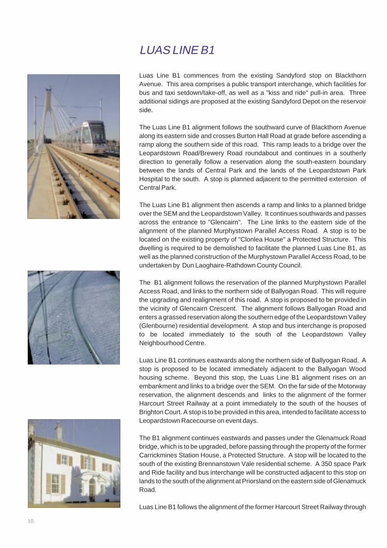
Luas Line B1 commences from the existing Sandyford stop on BlackthornAvenue. This area comprises a public transport interchange, which facilities forbus and taxi setdown/take-off, as well as a "kiss and ride" pull-in area. Threeadditional sidings are proposed at the existing Sandyford Depot on the reservoirside.
The Luas Line B1 alignment follows the southward curve of Blackthorn Avenuealong its eastern side and crosses Burton Hall Road at grade before ascending aramp along the southern side of this road. This ramp leads to a bridge over theLeopardstown Road/Brewery Road roundabout and continues in a southerlydirection to generally follow a reservation along the south-eastern boundarybetween the lands of Central Park and the lands of the Leopardstown ParkHospital to the south. A stop is planned adjacent to the permitted extension ofCentral Park.
The Luas Line B1 alignment then ascends a ramp and links to a planned bridgeover the SEM and the Leopardstown Valley. It continues southwards and passesacross the entrance to "Glencairn". The Line links to the eastern side of thealignment of the planned Murphystown Parallel Access Road. A stop is to belocated on the existing property of "Clonlea House" a Protected Structure. Thisdwelling is required to be demolished to facilitate the planned Luas Line B1, aswell as the planned construction of the Murphystown Parallel Access Road, to beundertaken by Dun Laoghaire-Rathdown County Council.
The B1 alignment follows the reservation of the planned Murphystown ParallelAccess Road, and links to the northern side of Ballyogan Road. This will requirethe upgrading and realignment of this road. A stop is proposed to be provided inthe vicinity of Glencairn Crescent. The alignment follows Ballyogan Road andenters a grassed reservation along the southern edge of the Leopardstown Valley(Glenbourne) residential development. A stop and bus interchange is proposedto be located immediately to the south of the Leopardstown ValleyNeighbourhood Centre.
Luas Line B1 continues eastwards along the northern side of Ballyogan Road. Astop is proposed to be located immediately adjacent to the Ballyogan Woodhousing scheme. Beyond this stop, the Luas Line B1 alignment rises on anembankment and links to a bridge over the SEM. On the far side of the Motorwayreservation, the alignment descends and links to the alignment of the formerHarcourt Street Railway at a point immediately to the south of the houses ofBrighton Court. A stop is to be provided in this area, intended to facilitate access toLeopardstown Racecourse on event days.
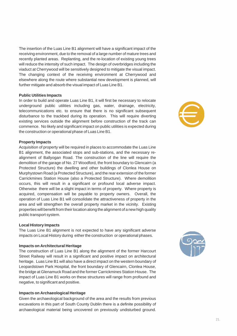
The B1 alignment continues eastwards and passes under the Glenamuck Roadbridge, which is to be upgraded, before passing through the property of the formerCarrickmines Station House, a Protected Structure. A stop will be located to thesouth of the existing Brennanstown Vale residential scheme. A 350 space Parkand Ride facility and bus interchange will be constructed adjacent to this stop onlands to the south of the alignment at Priorsland on the eastern side of GlenamuckRoad.
Luas Line B1 follows the alignment of the former Harcourt Street Railway through
LUAS LINE B1

11.
Carrickmines Wood and into the townland of Laughanstown. A Luas stop will belocated at a point to the north of the planned Cherrywood Spine Road and to theeast of the existing Brennanstown Vale residential scheme.
It crosses the alignment of the planned Cherrywood Spine Road by means of agrade-separated underpass. A stop will be located at the eastern side ofLaughanstown Lane. A pedestrian access will link to the planned Cherrywoodspine road.
Luas Line B1 then follows the southern side of the planned Cherrywood SpineRoad across the lands of Laughanstown. A stop will be located in the proposedplaza area of the planned District Centre at Cherrywood. The Luas Line B1 thencontinues southeast over the Wyattville Link Road into the Science andTechnology Park at Cherrywood. From a point to the east of Laughanstown Lanethe alignment will be elevated over existing ground level in the from of a viaductstructure to cross the Wyattville Link Road with necessary clearance. The LuasLine B1 terminates with a stop to the south of the existing Science and TechnologyPark.
Luas Line B1 will involve the construction of approximately 7.6km of light railwaybetween Sandyford Industrial Estate and Cherrywood, including double track,tram stops, associated structures, and an overhead electricity supply systemwhich will power the Luas system. The standard European track gauge will beused, which is the same as that used for the existing Luas Green and Red Lines.Apart from where it crosses a number of residential estate entrance roads atgrade, and at Laughanstown Lane, the Luas Line B1 alignment will run off-street,or on reserved lands, dedicated overbridges and underpasses, as well as alongthe alignment of the former Harcourt Street Railway.
Power supply to the tram is from overhead wires, allowing adequate clearance forgeneral traffic including delivery vehicles. The overhead electricity wires will besupported by poles.
The trams will be 40 metres in length with flexibility to allow the future insertion ofan additional section. The trams will have a low floor height to provide access toall customers including persons with a mobility impairment. The normal carryingcapacity of a tram is about 310 persons.
General service frequency is initially proposed to be at 5 minute intervals duringpeak hours in the morning and evening rush hours and 12-15 minute intervalsoutside these times. Trams will operate seven days a week from early morning tolate at night. The approximate journey time will be 19 minutes from Brides Glen toSandyford stop and 41 minutes in total from Brides Glen to St. Stephen’s Green.
The Luas stops are designed as low platforms on either side of the rail track.Platforms will have a typical height of about 300 mm above street level and therewill be ramps facilitating easy access for all passengers.

12.
Public consultation was initiated in November 2000, by means of the distribution
of a newsletter to all addresses in the vicinity of the route options for the Luas Line
B1 alignment which had been identified following preliminary assessment.
Newspaper notices were published in the national and local press. The
newsletter and newspaper notices included facility for recipients and readers to
forward comments to the Light Rail Project Office. A significant number of letters
and e-mails were received from interested parties.
Round-table meetings and public meetings were held with Residents
Associations and other Interest Groups, in both the immediate and wider vicinities
of the various alignment options. Discussions also took place with all of the
owners of residences which may have to be acquired to facilitate the planned
alignment.
A second newsletter, dated March 2001, was issued advising of the route options
and variants which remained under examination at that point in time. The variants
referred to emerged during the course of public consultation.
Consultation feedback on the variants:-
Preference for Ballyogan Road routing
Most respondents who expressed a preference for the Ballyogan Road routing
option reside in the vicinity of Ballyogan Road. The main reasons cited to support
their expressed preference were the poor level of existing public transport
available in this area and the need for a high quality public transport facility to
serve existing and future developments. Other reasons cited in preference of
Ballyogan Road included the greater relative catchment density. A number also
suggested that a routing along the alignment of the former railway would lead to
severe pressure on the road system in its vicinity, as intending passengers would
drive or would have to be driven to Luas stops from locations outside the walking
catchment.
Preference for routing on the alignment of the former Harcourt Street
Railway
Most respondents who expressed a preference for a routing along the alignment
of the former Harcourt Street Railway reside in the vicinity of this alignment. The
reasons cited in support of an HSR routing included lower capital cost, more direct
alignment, perceived avoidance of requirement for road space, nostalgia, and
personal convenience. There is also a clear perception of a need for bus feeder
services and park and ride facilities to allow passengers from locations outside the
walking catchment to avail of the Luas Line B1 alignment. Correspondence
indicating a preference for this alignment has also been received from Bray UDC,
Wicklow County Council and the Seaview Residents' Association (Shankill) who
are interested in the provision of services to areas to the east of Cherrywood.
PUBLIC CONSULTATION

13.
Other suggestions included routing along the South-Eastern Motorway,
development of both route options, and an extension to Cherrywood via the
alignment of the former Harcourt Street Railway and a "spur" from Cherrywood to
Ballyogan.
The key issues raised in relation to the proposals included:-
• visual impact, • noise impact,• acquisition of property,• boundary treatment, • park and ride facilities, and.• pedestrian access to stops, and • anti-social behaviour• traffic and safety concerns
In December 2004, the RPA organised a public open-day to update members of
the public in relation to the status of plans for the line. The open-day was held in
County Hall Dun Laoghaire and was very well attended and members of the RPA
were on hand to discuss any issues raised by attendees.
At each and every step of the consultation process it was made clear that the RPA
was ready and willing to consult with interested parties in an open and
professional manner. The process of consultation is ongoing and has served to
confirm the generally positive acceptance and enthusiasm for the establishment
of Luas Line B1and the Luas in general.
Luas Line B1 Glenacairn Stop

14.
Luas Line B1 will be built over a period of approximately 38 months. Construction
will be carefully organised and managed in order to accommodate day-to-day life
as it proceeds, and to retain local access to residences and premises. The
manner and timing of local access will be agreed with the Local Authority prior to
construction commencing and will be carefully monitored on a day-to-day basis.
The preferred and re-alignment of Ballyogan Road will be required to occur prior
to the Luas engineering works in this area. It is proposed to construct the Luas
Line B1 alignment in sections. The construction of related structures will also be
carefully organised and managed.
There will be a number of temporary construction compounds and assembly
areas connected with the construction of the Luas Line B1 alignment. The
following locations have been identified for compounds:-
Existing Sandyford Luas Depot area
Burton Hall Road, Southern Side
South of the SEM in the vicinity of Central Park
North of the SEM in the vicinity of the planned Leopardstown Luas Bridge
North of Murphystown Road, in the vicinity of Glencairn
East of Murphystown Road, south of Glencairn
East of the public playing fields on the northern side of Ballyogan Road
East of the Luas Line B1 alignment at Carrickmines, north of the SEM
In the vicinity of the grade-separated intersection of the Luas Line B1
alignment with the Cherrywood Spine Road, to the west of Laughanstown
Lane
LUAS LINE B1 CONSTRUCTION PHASE
HOW, WHERE AND WHEN?

15.
Luas Line B1 will provide an attractive alternative to the private car. The servicewill be complemented by traffic management and traffic reduction schemesalong the route, particularly in the area of Sandyford Industrial Estate.
The preferred route makes the most use of existing public transport reservations.It will be easily integrated with surrounding land use and will provide an attractivenew urban transport service. It will serve the large employment centres of theSandyford and Stillorgan Industrial Estates, Central Park, the IDA South CountyBusiness Park, planned new employment related development atStepaside/Carrickmines as well as the expanding Science and Technology Parkat Cherrywood. It will also serve the existing and planned new residential areasof Sandyford, Leopardstown, Stepaside, Carrickmines and Cherrywood. LuasLine B1 has also been designed to facilitate easy interchange with other modesof transport, in particular buses and private cars.
OPERATION OF LUAS LINE B1

16.
It is proposed to develop a Park & Ride facility at Carrickmines in order to attractsignificant numbers of motorists away from their cars on to Luas Line B1. At theexisting Sandyford Stop, a bus interchange and taxi rank, as well as a "kiss andride" set-down area, are provided. Bus interchange facilities will also be providedat Ballyogan Road.
The Luas makes a clear statement about the future role of public transport in theDTO area. Two Luas lines are currently in operation; comprising the Luas GreenLine connecting Sandyford with St. Stephen’s Green and the Luas Red Lineconnecting Tallaght with Connolly Station. Luas connects with other modes oftransport, such as buses, coaches and trains. The majority of tram stops areserved by a nearby Dublin Bus Stop. Irish Rail services at Heuston Station andConnolly Station are also readily accessible to passengers on the Luas Red Line.
LINKS TO OTHER TRANSPORTATION
SERVICES

17.
There are 11 stops proposed along the Luas Line B1 alignment, as follows:-
Central Park
Glencairn
The Gallops
Leopardstown Valley
Ballyogan Wood
Racecourse (a stop intended for use on event days at Leopardstown Racecourse)
Carrickmines
Brennanstown
Laughanstown
Cherrywood
Bride’s Glen
LUAS STOPS

18.
LIKELY AND SIGNIFICANT ENVIRONMENTAL IMPACTS
Population and Employment Impacts The total population living within convenient walking distance of the Luas stopsalong the Line B1 alignment is currently some 32,367 persons according to the2002 Census of Population. Dun Laoghaire-Rathdown County DevelopmentPlan 2004-2010 estimates that over the next 8-10 years some 4,000-5,000 newhousing units will be constructed within the Stepaside Area. In addition the Planestimates that some 20,000 new residents will be facilitated in theCherrywood/Rathmichael area. In addition, approximately 20,000 people arecurrently employed in the Stillorgan Business Park, Sandyford Industrial Estateand IDA South County Business Park. There is still capacity in SandyfordIndustrial Estate to facilitate significant further development. The CountyDevelopment Plan estimates that the future employment population atCherrywood will amount to some 10,000 persons.
Construction works will generate employment opportunities for both the local andregional labour forces. There will be no direct impact on household size andcomposition during the construction of the Luas Line B1 alignment. Because thealignment is off-street for virtually all of the route, disturbance will be localised andlimited to bridgeworks and areas where the alignment crosses, or runs alongsidethe existing road network. Disturbance will also be experienced during theupgrading and re-alignment works to Ballyogan Road.
No likely and significant impact on overall size, age profile or average householdsize is predicted as a direct consequence of the operation of Luas Line B1.However, an increase in population is planned to occur over time as extensivelands in this area are developed for residential and employment use. It is likely thatLuas Line B1 will facilitate some shift away from the use of private to publictransport. However, car ownership rates amongst the resident population are notexpected to change significantly.
Land Use Planning and Development ImpactsThere will be some local short term and temporary significant impacts on landuses adjoining Luas Line B1 during the construction process, both due to theconstruction of the alignment itself, and due to the associated upgrading and re-alignment of Ballyogan Road . However, the proposed Luas Line B1 will complywith the objectives of the Dun Laoghaire-Rathdown County Development Plan2004-2010, the earlier Stepaside Action Plan 2000, the Draft Carrickmines-Cherrywood Action Plan, and the DTO Strategy 2000-2016 to provide a light raillink between Sandyford Industrial Estate and Cherrywood. It will provide asignificant benefit for existing and planned new residential and employment landuses along its route.
Vehicular and Pedestrian Traffi c and Safety ImpactsNeither the construction nor the operation of Luas Line B1 will have a significantimpact on vehicular or pedestrian traffic and safety since the alignment is primarilyoff-street, except for the limited number of at-grade road crossings proposed.
WHO AND WHAT WILL BE AFFECTED BY
LUAS LINE B1 ?

19.
Facilities for pedestrians will be enhanced through the provision of controlledcrossings at all at-grade junction crossings of the Luas Line B1 alignment. Thecycling environment will also benefit as a result of the delivery of Luas Line B1,through the provision of cycle parking facilities at stop locations and the provisionof cycle tracks on the upgraded and realigned Ballyogan Road. In addition, theprovision of bus interchanges at the Ballyogan and Carrickmines stops, inaddition to the existing Sandyford stop will provide interchange between bus andLuas modes.
Community Severance ImpactsDuring the construction phase, there will be short-term disruption to localpedestrian and vehicle flow near parts of the Luas Line B1 alignment. However,the introduction of appropriate management measures, including new footpathsalong Ballyogan Road and Blackthorn Avenue, combined with the temporarynature of the construction works will result in a slight severance impact.
Flora and Fauna ImpactsImpacts on flora and fauna, arising from Luas Line B1 are assessed as locallysignificant in places over the short term. Replacement planting will reduce thesignificant impact predicted during the construction phase to moderate in themedium term and slight in the long term, as replacement tree and hedgerowcover matures.
Soil ImpactsNo likely or significant impacts are predicted during the construction phase orduring the operational phase. During the construction phase of Luas Line B1 thecontractor will be bound by the terms of the contract to exercise due care in thehandling and disposal of any potentially contaminated material.
Water ImpactsProper and strict site management practice will minimise the potential for anyspillage of waste materials into watercourses. During the construction phase thecontractor will be bound by the terms of the contract to exercise due care in thehandling and disposal of any material which could contaminate the waterenvironment.
Noise ImpactsDuring the construction phase, the predicted impact of noise varies from slight tosignificant. Any adverse noise will be short term and intermittent and for the mostpart will be similar to that which occurs during the laying and generalmaintenance works associated with public utilities and road works. Hours ofconstruction work will be limited in order to minimise impact on residents. Withthe operation of Luas Line B1, the predicted noise impact varies from none toslight and moderate. The trams will incorporate noise control measures tominimise noise effects. It should also be noted that the existing noiseenvironment along much of the route will alter with the provision of planned newdevelopment, particularly the opening of the SEM.
20.
Vibration ImpactsDuring the construction phase some vibration impacts will arise. However thescale of these will vary from negligible to slight/moderate. During the operation ofthe Luas Line B1 alignment there will be a neutral impact related to vibration.Overall, a negligible vibrational impact is predicted.
Lighting ImpactsThe potential night-time lighting of the construction compounds and assemblyareas may have a temporary impact, though this is not predicted to be significant.The proposal will not have any significant adverse impact on natural lightingalong the route. Future planned new development along the route will introducea new public lighting source to the local environment. It is anticipated thatpersons will quickly become accustomed to infrequent flashing and sparkingfrom the Luas overhead lines, such that its limited intrusion will not constitute anadverse impact of any significance.
Electromagnetic ImpactsElectromagnetic impacts relate to potential for interference with electricalequipment of one type or another and also the escape of stray electrical currentfrom the electric wiring system used to operate the trams. Suitable measures willbe incorporated in the design of the trams, rails and the electrical apparatus toensure that the relevant EU standards are adhered to. When this isimplemented, no significant adverse impacts are expected from theelectromagnetic effects of the project.
Air Quality The construction phase along any part of the Luas Line B1 alignment will betemporary, and proper site management will effectively control such emissionsso they do not result in a local air quality nuisance, either from dust or gaseousemissions. Any impact on air quality in terms of dust deposition rates andairborne particulates will vary from neutral to slight.
Landscape ImpactsConstruction activities associated with Luas will be temporary in nature andrelatively localised. Such impacts are a common feature of the urban/suburbanlandscape and are not considered to be significant in landscape terms. Theinsertion of the Luas alignment will have locally significant impacts, particularlyfrom Laughanstown to Cherrywood, which is a largely open landscape setting atpresent. This area will however be profoundly altered by substantialdevelopment planned for these zoned lands. Elsewhere the proposed alignmentand associated works will yield positive impacts, particularly as landscapeplanting matures along the route. Co-ordinated design of all Luas stops, sub-stations and associated structures will generally yield positive impacts. All ofthese elements will provide a coherent and well designed built environmentalong the corridor. In time the overall impact of the Luas Line B1 alignment onlandscape will be positive.
Visual ImpactsThe visual impacts of Luas Line B1 are likely to be significant in places fromSandyford stop to Bride’s Glen. These impacts will generally be negative duringthe construction phase and neutral or positive during the operational phase.
21.
The insertion of the Luas Line B1 alignment will have a significant impact of thereceiving environment, due to the removal of a large number of mature trees andrecently planted areas. Replanting, and the re-location of existing young treeswill reduce the intensity of such impact. The design of overbridges including theviaduct at Cherrywood will be sensitively designed to mitigate the visual impact.The changing context of the receiving environment at Cherrywood andelsewhere along the route where substantial new development is planned, willfurther mitigate and absorb the visual impact of Luas Line B1.
Public Utilities ImpactsIn order to build and operate Luas Line B1, it will first be necessary to relocateunderground public utilities including gas, water, drainage, electricity,telecommunications etc. to ensure that there is no significant subsequentdisturbance to the trackbed during its operation. This will require divertingexisting services outside the alignment before construction of the track cancommence. No likely and significant impact on public utilities is expected duringthe construction or operational phase of Luas Line B1.
Property ImpactsAcquisition of property will be required in places to accommodate the Luas LineB1 alignment, the associated stops and sub-stations, and the necessary re-alignment of Ballyogan Road. The construction of the line will require thedemolition of the garage of No. 27 Woodford, the front boundary to Glencairn (aProtected Structure) the dwelling and other buildings of Clonlea House onMurphystown Road (a Protected Structure), and the rear extension of the formerCarrickmines Station House (also a Protected Structure). Where demolitionoccurs, this will result in a significant or profound local adverse impact.Otherwise there will be a slight impact in terms of property. Where property isacquired, compensation will be payable to property owners. Overall, theoperation of Luas Line B1 will consolidate the attractiveness of property in thearea and will strengthen the overall property market in the vicinity. Existingproperties will benefit from their location along the alignment of a new high qualitypublic transport system.
Local History ImpactsThe Luas Line B1 alignment is not expected to have any significant adverseimpacts on Local History during either the construction or operational phases.
Impacts on Architectural HeritageThe construction of Luas Line B1 along the alignment of the former HarcourtStreet Railway will result in a significant and positive impact on architecturalheritage. Luas Line B1 will also have a direct impact on the western boundary ofLeopardstown Park Hospital, the front boundary of Glencairn, Clonlea House,the bridge at Glenamuck Road and the former Carrickmines Station House. Theimpact of Luas Line B1 works on these structures will range from profound andnegative, to significant and positive.
Impacts on Archaeological HeritageGiven the archaeological background of the area and the results from previousexcavations in this part of South County Dublin there is a definite possibility ofarchaeological material being uncovered on previously undisturbed ground.

22.
Should such material be discovered in an area during the construction of LuasLine B1, a significant archaeological impact may result. All construction work inthat area would have to cease and the area be fenced off. All archaeologicalissues will have to be resolved to the satisfaction of Duchas and the NationalMuseum of Ireland. Significant test trenching has been carried out at sensitivelocations under licence as part of this Environmental Impact Assessment.
No likely and significant impacts on archaeology are predicted during theoperation stage of Luas.

23.
The DTI Final Report emphasised positive inter-relationships between land useand transportation. This is particularly applicable to Luas. The development andoperation of Luas Line B1 from Sandyford Industrial Estate to Cherrywood, willgenerate a likely and significant interaction between the mobility and accessibilityof the catchment population, and the land use and development trends along theroute corridor. Specific interactions are identified as follows:-
Human Beings/The Landscape/Visual IssuesThe Luas Line B1 alignment, together with its overhead lines and ancillarystructures, including three bridges, will be observed by pedestrians and residentsas they become accustomed to the new environment. Overall, there will be longterm positive visual impacts resulting from environmental improvementsassociated with the Luas Line B1 alignment, and the maturing of remediallandscaping. Furthermore, the wider area of the alignment is planned to besignificantly altered by major new development, and by the provision of new local,regional and National road infrastructure.
Flora/The Landscape/Human BeingsThe removal of existing foliage and trees during construction of the Luas Line B1alignment will interact with the landscape environment. The introduction of newplanting where appropriate alongside the alignment and u along the plannedBallyogan Road alignment will help to establish a new landscape and flora.
Material Assets/Human BeingsThe operation of the Luas Line B1 alignment will provide a new permanent publictransport service for this suburban area, which is planned to accommodate asignificant new resident and employment population. Luas will provide anefficient public transport alternative to the private car, and will link the area to theexisting or planned employment areas of Sandyford/Leopardstown, Cherrywoodand Dublin City Centre. This will achieve Statutory planning policy and objectivesrelating to public transport.
Material Assets/Flora/FaunaThe loss of vegetation necessary for the proposal will result in a loss of cover andhabitat for insects, birds and mammals, and disturbance along the route which willreduce its use as a corridor for animal movement. New landscape planting, as wellas the retention of a significant extent of existing flora in the area will ensure aslight overall impact in terms of interaction between material assets and flora andfauna.
Human Beings/Material Assets/LandscapeThe construction of the Luas Line B1 alignment will run along a landscapedcorridor, which is almost entirely segregated from the existing road infrastructure.This will ensure a minimum of conflict with existing and planned future vehicular orpedestrian traffic movement in the area.
INTERACTIONS