linking communities, commerce, industry and science
TRANSCRIPT
What do Portland State University, OHSU, and OMSI have in common with Central Eastside, Sellwood/Moreland and Milwaukie? In the future, all will be linked by a new MAX light rail line from downtown Portland through southeast neighborhoods and into north Clacka-mas County. The Portland to Milwaukie Light Rail project - the second part of a two-phased plan to bring light rail to the southeast portion of the region – is in the final phase of environ-mental analysis, a supplemental draft Environ-mental Impact Statement (SDEIS).
Metro is leading the project in partnership with TriMet, ODOT, Multnomah and Clackamas counties, and the cities of Portland, Milwaukie and Oregon City.
The project will extend the region’s popular light rail system on a new 6.5 mile alignment from downtown Portland, across the Willamette River, and south to Milwaukie or possibly Oak Grove. Project planning will continue – with opportunities for public input – through summer 2008. Construction could occur as soon as 2011.
ABriefHistory
The Portland to Milwaukie light rail alignment has been studied and evaluated several times over the past 25 years. In fact, it was one of the first corridors considered at the onset of regional light rail planning in the 1980s. The current project is Phase II of the South Corridor Study. Phase I resulted in the light rail project currently under construction on the downtown Portland transit mall and I-205.
The current study is re-evaluating the 2003 Locally Preferred Alternative (LPA), the light rail alignment recommended by the public. The SDEIS is updating the LPA for environmental changes since 2003 and consulting with commu-nities about additional design options to con-sider. A growing regional population, changing land uses and emerging development opportuni-www.metro-region.org
ties in South Waterfront, the Central Eastside and downtown Milwaukie require a fresh look.
Alternatives
• NoBuild • LightRailAlternative
AlignmentOptions
• 2003LPA,plus: • FourWillametteRivercrossingoptions • TillamookBranchalignmentoption • ParkAvenueextensionoption
AlternativesandAlignmentOptions
The SDEIS is considering two alternatives – the No Build and the Light Rail alternative. Basi-cally this means looking at what the southeast region’s transportation options will be in the future with and without light rail. The No Build alternative provides a basis for comparing the benefits, costs and impacts for the 2003 LPA and alignment options.
The No Build considers existing transit services and facilities as well as planned improvements from the Regional Transportation Plan by 2025. It includes modest upgrades for existing bus ser-vice and additional park and ride facilities in the corridor, such as the already-planned 330-space park and ride at the former Southgate Cinema. The No Build alternative also includes current and planned road improvements, such as street network improvements and better I-5 access for South Waterfront.
The Light Rail alternative is a new 6.5-mile light rail line extending from the MAX network under construction on Portland’s downtown transit mall at SW Jackson Street to a southern terminus at either SE Lake Road in Milwaukie or SE Park Avenue near Oak Grove. The line features 11-13 new light rail stations and three
Continued
600 NE Grand Ave.Portland, OR97232-2736
(503) 797-1700
PROJECT PARTNERS
Metro
Oregon Department of Transportation
TriMet
Clackamas County
Multnomah County
City of Portland
City of Milwaukie
City of Oregon City
AlignmentOverview
FALL2007 ALIGNMENTOVERVIEW
www.metro-region.org/southcorridor
Linkingcommunities,commerce,industryandscience
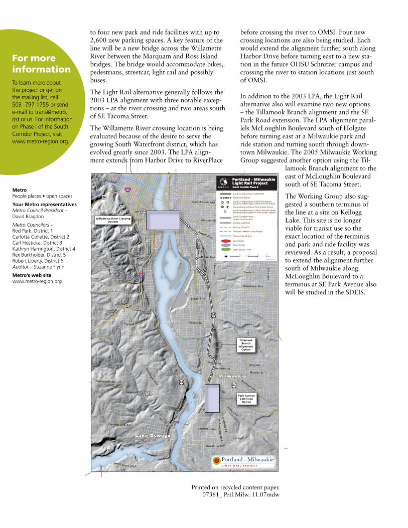
to four new park and ride facilities with up to 2,600 new parking spaces. A key feature of the line will be a new bridge across the Willamette River between the Marquam and Ross Island bridges. The bridge would accommodate bikes, pedestrians, streetcar, light rail and possibly buses.
The Light Rail alternative generally followsthe 2003 LPA alignment with three notable excep-tions – at the river crossing and two areas south of SE Tacoma Street.
The Willamette River crossing location is being evaluated because of the desire to serve the growing South Waterfront district, which has evolved greatly since 2003. The LPA align-ment extends from Harbor Drive to RiverPlace
before crossing the river to OMSI. Four new crossing locations are also being studied. Each would extend the alignment further south along Harbor Drive before turning east to a new sta-tion in the future OHSU Schnitzer campus and crossing the river to station locations just south of OMSI.
In addition to the 2003 LPA, the Light Rail alternative also will examine two new options – the Tillamook Branch alignment and the SE Park Road extension. The LPA alignment paral-lels McLoughlin Boulevard south of Holgate before turning east at a Milwaukie park and ride station and turning south through down-town Milwaukie. The 2005 Milwaukie Working Group suggested another option using the Til-
lamook Branch alignment to the east of McLoughlin Boulevard south of SE Tacoma Street.
The Working Group also sug-gested a southern terminus of the line at a site on Kellogg Lake. This site is no longer viable for transit use so the exact location of the terminus and park and ride facility was reviewed. As a result, a proposal to extend the alignment further south of Milwaukie along McLoughlin Boulevard to a terminus at SE Park Avenue also will be studied in the SDEIS.
MetroPeople places • open spaces
Your Metro representativesMetro Council President – David Bragdon
Metro Councilors – Rod Park, District 1Carlotta Collette, District 2Carl Hosticka, District 3 Kathryn Harrington, District 4 Rex Burkholder, District 5 Robert Liberty, District 6 Auditor – Suzanne Flynn
Metro’s web sitewww.metro-region.org
FormoreinformationTo learn more about the project or get on the mailing list, call 503 -797-1755 or send e-mail to [email protected]. For information on Phase I of the South Corridor Project, visit www.metro-region.org.
Printed on recycled content paper.07361_ Prtl.Milw. 11.07mdw
P
P
P
ParkPark
Lake Rd.
Lake Rd.
Tacoma St.Tacoma St.
BybeeBybee
Holgate Blvd.Holgate Blvd.
Powell Blvd.
Powell Blvd.
Division St.Division St.
H a w t h o r n eH a w t h o r n e
52ndAve.
52ndAve.
39th
Ave.
39th
Ave.
Alder c rest
Alder c rest
River
R
d.
River
R
d.
RailroadAve.
RailroadAve.
Monroe St.Monroe St.
King Rd.King Rd.
Steele St.Steele St.M
cLoughlin
Blvd
.
M
cLoughlin
Blvd
.
26th
Ave.
26th
Ave.
Woodstock Blvd.Woodstock Blvd.
Courtney Ave.Courtney Ave.
Oatfi
eld
Rd.
Oatfi
eld
Rd.
McLoughl in
Bl vd.
McLoughl in
Bl vd.
Hil l Rd.Hil l Rd.
Oak Grove Blvd.Oak Grove Blvd.
Thiessen
Rd.
Thiessen
Rd.
South Shore Blvd.South Shore Blvd.
Country Club Rd.Country Club Rd.
Boon
esFer
ryRd
.
Boon
esFer
ryRd
.
Stephenson St.Stephenson St.
Terw
il l iger
Blvd.
Terw
il l iger
Blvd.
Ta y l o r s F e rr y
R d .
Ta y l o r s F e rr y
R d .
SunsetBlvd
.
SunsetBlvd
.
Harrison St.Harrison St.
Ave.Ave.
Blvd.Blvd.
17th
Ave.
17th
Ave.
Hwy 224Hwy 224
Blvd.Blvd.
MilwaukieMilwaukie
Lake OswegoLake Oswego
Tryon Creek State ParkTryon Creek State Park
HillsdaleHillsdale
5
205
224
99E
26
43
26
Tillamook Branch
Alignment Option
Willamette River Crossing Options
Park Avenue Extension
Option
Portland - Milwaukie Light Rail ProjectPortland - Milwaukie Light Rail ProjectSouth Corridor Phase II South Corridor Phase II
South Corridor Phase II 2003 LPA
Existing Light Rail
South Corridor Phase I (under construction)
Existing Streetcar
Portland Streetcar Loop Project
Central City
Town Center
Open Spaces - Park
Portland Aerial Tram
Miles¼ ½ ¾ 1
Alignment Option
September 2007
South Corridor Phase II 2003 LPA station/South Corridor Phase II 2003 LPA Park & Ride
Station Design Option/ Park & Ride OptionP
P
South Corridor Phase II 2003 LPA Park & Ride/ Station Design Option or Park & Ride OptionP
P
Portland –MilwaukieL I G H T R A I L P R O J E C T