local planning policy 5 - broome.wa.gov.au · shire of broome policy manual 5.23 page 1 local...
TRANSCRIPT

Shire of Broome Policy Manual 5.23 Page 1
LOCAL PLANNING POLICY 5.23
TITLE: COASTAL PLANNING POLICY
ADOPTED: OMC 28 February 2019 – Pages 190-221
REVIEWED: OMC……………………….. – Pages
OMC……………………….. – Pages
OMC……………………….. – Pages
OMC……………………….. – Pages
ASSOCIATED
LEGISLATION:
Planning and Development Act 2005
Planning and Development (Local Planning Schemes)
Regulations 2015
ASSOCIATED
DOCUMENTS:
State Planning Policy 2.6 – State Coastal Policy
Broome Townsite Coastal Hazard Risk Management
Adaptation Plan
REVIEW
RESPONSIBILITY: Director Development Services
DELEGATION: N/A
Objective:
1. To ensure land in the coastal zone is continuously provided
for coastal foreshore management, publ ic access,
recreation and conservation.
2. To ensure public safety and reduce risk associated with
coastal erosion and inundation.
3. To avoid inappropriate land use and development of land
at r isk from coastal erosion and inundation.
4. To ensure land use and development does not accelerate
coastal erosion or inundation risks; or have a detrimental
impact on the functions of public reserves.
5. To ensure that development addresses the Broome Townsite
Coastal Hazard Risk Management and Adaptation plan
prepared in accordance with State Planning Pol icy No. 2.6
Coastal Planning Policy (as amended).

Shire of Broome Policy Manual 5.23 Page 2
Policy:
Definitions:
The words and phrases set out in this policy are in addit ion to
those identif ied in State Planning Policy 2.6 – State Coastal
Planning Policy (SPP2.6).
‘Australian Height Datum’ (or AHD) is the vert ical survey datum
adopted.
‘Average Recurrence Interval’ (or ARI) is a term used to describe
an inundation or erosion event size. It is a means of describing
how l ikely an inundation or erosion hazard is to occur in a given
year.
‘Coastal Compartments’ are areas delineated along the Broome
coast with similar geomorphological characterist ics, coastal
processes and geographical locations of interest in accordance
with Appendix 2.
‘Habitable room ’ as a room used for normal domestic activit ies
that includes:
• a bedroom, l iving room, lounge room, music room, sitt ing
room, television room, kitchen, dining room, sewing room,
study, playroom, sunroom, gymnasium, ful ly enclosed
swimming pool or patio; but excludes
• a bathroom, laundry, water closet, food storage pantry,
walk- in wardrobe, corridor, hallway, lobby, photographic
darkroom, clothes drying room, verandah and unenclosed
swimming pool or patio and other spaces of a special ised
nature occupied neither frequently nor for extended
periods.
‘Horizontal Shoreline Datum ’ (or HSD) defines the active l imit of
the shorel ine under storm activity. It is the l ine from which a
physical processes al lowance wil l be applied from.
‘Finished Floor Level’ (or FFL) is the height above ground at which
habitable floor levels in a commercial or residential building are
constructed (datum AHD).
‘Likelihood’ means the probabil ity that something wil l occur.
Likel ihood is generally expressed qualitatively or quantitatively.

Shire of Broome Policy Manual 5.23 Page 3
‘Net lettable area’ is defined as: “…the area of al l floors within
the internal f inished surfaces of permanent walls but excludes the
fol lowing areas:
(a) al l stairs, toilets, cleaner’s cupboards, l ift shafts and
motor rooms, escalators, tea rooms, and plant rooms, and
other service areas;
(b) lobbies between l ifts facing other l ifts serving the same
floor;
(c) areas set aside as publ ic space or thoroughfares and not
for the exclusive use of occupiers of the floor or building;
(d) areas set aside for the provision of facil it ies or services
to the floor or building where such facil it ies are not for the
exclusive use of occupiers of the floor or building.”
Application:
This policy applies to al l land identif ied by the Shire as being
subject to coastal erosion and inundation r isk as outl ined by
Special Control Area No.9 (SCA9) in Shire of Broome’s Local
Planning Scheme No. 6 (LPS6).
The provisions of SCA9 only consider inundation from storm surge
and an elevated ocean level. It does not include any
consideration of catchment-based storm water runoff.
The provisions of SCA9 do not apply where a development i s
proposed on land entirely outside the mapped SCA9 extent, even
if a portion of the lot upon which the development is proposed is
included. For example, a lot may have a partial encroachment within the
SCA boundary, however, if the proposed development is located outside
the SCA area, the policy would not apply.
The boundary of SCA9 is provided in Appendix 1.
This policy does not apply to coastal structures identif ied in SPP2.6
Section 7 (e.g. Public recreation facil it ies with finite l ifespan ,
Coastal ly dependent and easily relocatable development , Surf
Lifesaving Clubs).
Exempt Development:
In accordance with clause 5.2.9.2 of LPS6, al l future development
within SCA9 requires development approval with the exception
of the fol lowing:
1. temporary or non-permanent structures not used for human
habitation;

Shire of Broome Policy Manual 5.23 Page 4
2. extensions to an exist ing single, grouped or multiple dwell ing
where the gross f loor area of the proposed extensions is no
more than 50m2 ; and
3. change of use to a ‘Permitted’ use where no new structures
are proposed.
Background:
The Coastal Planning Pol icy has been developed to assist with
the implementation of Special Control Area No.9 – Coastal
Hazard Risk Area (SCA9).
SCA9 identif ies areas in Broome townsite that are at r isk from
coastal hazard risk within the 2110 planning t imeframe. The land
subject to coastal hazard risk is either:
• Low lying areas susceptible to inundation from a storm surge
event with a one-in-f ive hundred probabil ity of being
exceeded in any given year (500yr ARI event); or
• Coastal areas within the coastal processes al lowance
setback extent for erosion, calculated for the 2110 planning
timeframe.
The planning requirements set out in this policy are informed by
the Shire’s Coastal Vulnerabil ity Study (CVS) and subsequent
Coastal Hazard Risk Management and Adaptation Plan
(CHRMAP). The CVS considers the coastal inundation and erosion
hazards across the Broome townsite, whilst the CHRMAP provides
a holist ic approach to manage and mit igate coastal hazard risk,
and has been developed in consultation with the local
community and key stakeholders.
The Broome Townsite CHRMAP identif ies
nine coastal compartments based on
geomorphological characterist ics,
coastal processes and geographical
locations of interest (Appendix 2).
The adaptation requirements for each
coastal compartment have been
developed in accordance with the risk
management and adaptation hierarchy
as set out in SPP2.6. This policy provides
guidance in the implementation of the CHRMAP adaptation
strategies included in Appendix 3.

Shire of Broome Policy Manual 5.23 Page 5
Storm Surge Inundation
Adaptation Requirements for Properties Affected by Storm Surge
Inundation
1.1. Where development is affected by storm surge, the
appl icant is required to ensure minimum Finished Floor Level
for al l habitable rooms or net lettable areas for commercial
/ retail / community buildings as outl ined in Broome Town
Centre (Coastal Compartment No.7) and Dampier Creek
Inner (Coastal Compartment No.8).
Broome Town Centre (Coastal Compartment No.7)
1.2. Broome Town Centre Chinatown Peninsula Protected Area:
The Finished Floor Level for al l habitable rooms (dwell ings)
or al l net lettable area for commercial/ retail/ community
buildings to achieve a minimum FFL of 5.96m AHD.
1.3. Broome Town Centre Outside Protected Area: The Finished
Floor Level for all habitable rooms (dwell ings) or al l net
lettable area for commercial/ retail/ community buildings
to achieve a minimum FFL of 7.03m AHD.
The Broome Townsite CHRMAP identif ies that a seawall is to be
constructed in Broome Town Centre by 2070 to protect against
storm surge inundation of the Chinatown Peninsula. This
recommendation is made under the assumption that sea level
r ise of 0.4m wil l occur within the 2070 planning timeframe in
accordance with SPP2.6 recommendations.
The finished Floor Level recommendation for habitable rooms or
all net lettable area for commercial/ retail/ community buildings
in the Chinatown Peninsula is therefore based on the 100yr-ARI
storm surge level defined for the 2070 timeframe, which includes
0.4m sea level r ise.
The area of Chinatown designated for inundation protection is
shown in Appendix 4 with the 2070 design FFL recommendation.
For areas outside the protected area, the 2110 design FFL is
required.

Shire of Broome Policy Manual 5.23 Page 6
Dampier Creek Inner (Coastal Compartment No. 8)
1.4. Dampier Creek Inner: The Finished Floor Level for al l
habitable rooms (dwell ings) or al l net lettable area for
commercial/ retail/ community buildings to achieve a
minimum FFL of 7.03 AHD.
Dampier Creek East (Coastal Compartment No. 9)
1.5. Dampier Creek East: Avoid development of land prone to
storm surge inundation.
Additional Design Requirements
1.6. Addit ional design requirements may be required
depending on the difference between the storm surge
inundation level and the recommended FFL for al l habitable
rooms or net lettable areas for commercial / retail /
community buildings.
1.7. Design responses are not to have a detrimental impact on
the amenity of adjoining propert ies or the amenity of the
locality generally. This includes adversely impact ing storm
surge inundation levels on adjoining propert ies.
1.8. The minimum FFL for al l habitable rooms or net lettable
areas for commercial / retail / community buildings is to be
achieved through either f il l / retaining (to a maximum of
0.5m above natural ground level) or building design (i.e
elevated ‘Queenslander’ style stil t housing).
1.9. Fil l ing of the site between 500mm and 1 metre above
natural ground level is to be considered where it can be
demonstrated that it addresses the requirements of clause
1.7.
The 2110 timeframe is used as the basel ine to determine the
required Finished Floor Level in the Dampier Creek Inner
Compartment. No protection structure is proposed for the
compartment and a strategy to Accommodate storm surge is
recommended in the CHRMAP.
Shire of Broome Policy Manual 5.23 Page 7
1.10. Mechanical and electrical infrastructure (e.g. pump
stations, emergency generators) are to be elevated above
the required FFL and / or protected from the impact of
storm surge inundation.
1.11. Buildings are to be designed to withstand structural loads
associated with a storm surge inundation.
1.12. Foundations and footings are to be cert if ied by a coastal
engineer as adequate to withstand potential erosive action
during coastal inundation.
1.13. Lower levels of buildings prone to storm surge inundation
are to be permeable to al low water to flow through. This
would not apply if the design response includes f i l l to the
extent that the FFL of the building is located above the
identif ied level of inundation.
Erosion
Adaptation Requirements for Properties Affected by Coastal
Erosion
1.14. Unless provision is made within the CHRMAP for protection,
no permanent structures to be located within the coastal
erosion processes setback area for the 2110 planning
period. A copy of the coastal erosion processes affecting
Broome Townsite can be located in Appendix 5.
1.15. Structures, including residential development, that have a
l ifespan less than the 100-year coastal erosion planning
timeframe may be permitted providing they are consistent
with the CHRMAP adaptation strategies in Appendix 3 and
removed once the current r isk of erosion poses an
unacceptable r isk to a development or structure.
1.16. In instances where a protection option is not proposed, any
approval is to be condit ioned requir ing al l structures be
The current coastal erosion al lowance from an extreme storm
impacting the coast has been assessed by applying wave and
water level conditions from a design storm cons istent with the 1%
ARI (100-yr) event, and adopting present sea level conditions, as
recommended in SPP2.6. The current coastal erosion al lowance
is depicted as a yel low l ine in Appendix 5.

Shire of Broome Policy Manual 5.23 Page 8
removed at the cost of the land owner once the current r isk
of erosion poses a r isk to a development or structure, as
defined by the following tr iggers:
• When the distance from the most landward part of the
Horizontal Shorel ine Datum (HSD) to the most seaward
point of a development or structure is less than the S1
al lowance in the respective section of coast.
• Where a public road is no longer available or able to
provide legal access to the property.
• When water, sewage or electricity to the lot is no
longer available as they have been removed/
decommissioned by the relevant authority due to
coastal hazards.
1.17. Development in areas where a protection option is
identif ied within the CHRMAP are only required to be
setback landward of the current coastal erosion al lowance.
Notification on Tit le
1.18. In its determination of development applications for land
within SCA9, a notif ication is to be placed on the Certif icate
of Tit le, pursuant to section 70A of the Transfer of Land Act
1893:
VULNERABLE COASTAL AREA - This lot is located in an area
l ikely to be subject to coastal erosion and/or inundation
over the 100 planning t imeframe (2110).

Shire of Broome Policy Manual 5.23 Page 9
Appendix 1: Extent of Special Control Area No.9

Shire of Broome Policy Manual 5.23 Page 10
Appendix 2: Coastal Compartments

Shire of Broome Policy Manual 5.23 Page 11
Appendix 3: CHRMAP Adaptation Strategies
Coastal Compartment
Adaptation Strategy Recommendations
Cable Beach For areas north and south of central tourist area Planning Approach
• Avoid. Any future planning approaches will need to be sited landward of the identified 2110 planning period coastal erosion hazard.
For central section (Surf Club, Zanders café, Amphitheatre etc) Recommendations
• Further studies on a coastal protection option for up to 500m of the main foreshore area is recommended and supported through the CHRMAP with a view to adopting a Protect strategy for this section of coast. Will require a detailed erodibility study to determine the underlying geotechnical properties of the foreshore beneath the dune. Following the erodibility assessment, requirement for concept engineering, consultation with community/stakeholders and further economic analysis of option/s.
Planning Approach (general)
• Avoid further development of vacant land within the identified coastal erosion hazard area for areas north and south of the central tourist hub;
• Planned / Managed Retreat for existing assets located on land prone to coastal erosion within the 2110 planning timeframe for land not proposed to be protected by a seawall; and
• Accommodate land uses exempted by Part 7 of SPP 2.6 Schedule 1 e.g.. Community use of foreshore.
Planning Approach for areas behind a coastal protection structure (type of coastal protection, alignment and timing to be confirmed in future studies)
• Protect existing assets through a coastal protection structure. Shire Structures
• Managed Retreat for current structures and properties within the erosion hazard area.
Gantheaume Cliffs
Planning Approach
• Avoid further development within the identified 2110 coastal erosion hazard on vacant land; and
• Accommodate, Managed Retreat for existing assets located on land prone to coastal erosion within the 2110 planning timeframe (e.g. Broome Turf Club).
Shire Structures in foreshore areas
• Managed Retreat for coastal structures and roads.
Reddell Beach Planning Approach
• Avoid further development within the identified 2110 coastal erosion hazard on vacant land; and
• Accommodate, Managed Retreat for existing assets located on land prone to coastal erosion within the 2110 planning timeframe.
Shire Structures in foreshore areas
• Managed Retreat for coastal structures and roads.
Entrance Point Recommendations
• Recommended the Kimberley Port Authority undertake a detailed erodibility study to determine the underlying geotechnical properties of the foreshore area.
Planning Approach

Shire of Broome Policy Manual 5.23 Page 12
• Avoid further development within the identified 2110 coastal erosion hazard on vacant land; and
• Accommodate, Managed Retreat for existing assets located on land prone to coastal erosion within the 2110 planning timeframe.
Shire Structures in foreshore areas
• Managed Retreat for coastal structures and roads.
Simpsons Beach Planning Approach
• Avoid further development within the identified 2110 coastal erosion hazard on vacant land; and
• Accommodate, Managed Retreat for existing assets located on land prone to coastal erosion within the 2110 planning timeframe.
Shire Structures in foreshore areas
• Managed Retreat for coastal structures.
Town Beach Recommendations
• Further studies on construction of the Town Beach revetment (engineering, environmental and local stakeholder issues);
• Develop an appropriate Emergency Response Plan for the Roebuck Bay caravan park;
• Undertake a foreshore management plan; and
• Investigate remediation of the dune in front of the properties in Demco Drive.
Planning Approach
• Accommodate developable land located on land prone to coastal erosion within the 2110 planning timeframe;
• Accommodate Land uses exempted by Part 7 of SPP 2.6 Schedule 1 e.g. Community use of foreshore; and
• Protect existing assets through a coastal protection structure for areas landward of the planned revetment / seawall north of old jetty area.
Shire Structures in foreshore areas
• Managed Retreat for minor structures within the erosion hazard area;
• Accommodate for minor structures in the defined storm surge inundation area; and
• Protect Shire assets covered by the revetment / seawall at the eroding Pindan Cliff north of Old Jetty Groyne (Pioneer Cemetery, foreshore area in Town Beach Reserve).
Broome Central Recommendations
• A coastal protection structure to Protect Chinatown peninsula providing storm surge immunity and coastal erosion protection is supported through CHRMAP. Further studies required to determine type, alignment and timing. At latest the structure is assumed to be constructed for the 2070 planning period.
Planning Approach
• Accommodate developable land located on land prone to coastal erosion within the 2110 planning timeframe;
• Accommodate land prone to storm surge flooding through Special Control Area and specific requirements for planning approval of properties within the defined storm surge inundation area; and
• Accommodate Land uses exempted by Part 7 of SPP 2.6 Schedule 1 e.g. Community use of foreshore.
For areas within the Chinatown peninsula
• Protect Existing assets. Shire Structures in foreshore areas
• Managed Retreat for minor structures within the erosion hazard area; and
Shire of Broome Policy Manual 5.23 Page 13
• Accommodate for minor structures in the defined storm surge inundation area.
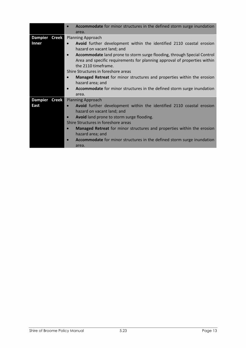
Dampier Creek Inner
Planning Approach
• Avoid further development within the identified 2110 coastal erosion hazard on vacant land; and
• Accommodate land prone to storm surge flooding, through Special Control Area and specific requirements for planning approval of properties within the 2110 timeframe.
Shire Structures in foreshore areas
• Managed Retreat for minor structures and properties within the erosion hazard area; and
• Accommodate for minor structures in the defined storm surge inundation area.
Dampier Creek East
Planning Approach
• Avoid further development within the identified 2110 coastal erosion hazard on vacant land; and
• Avoid land prone to storm surge flooding. Shire Structures in foreshore areas
• Managed Retreat for minor structures and properties within the erosion hazard area; and
• Accommodate for minor structures in the defined storm surge inundation area.

Shire of Broome Policy Manual 5.23 Page 14
Appendix 4: Broome Town Centre (Chinatown) Protection Area

Broome Coastal Planning PolicyChinatown Finished Floor Level Recommendations
Gray St
Short St
Frederick St
Napier TceH
amm
ersley St
Napier St
Bagot St
Dam
pier
Tce
Car
narv
on S
t
Broome Rd
FFL = 7.03mAHD FFL =7.03mAHD
FFL = 6.45mAHD

Shire of Broome Policy Manual 5.23 Page 15
Appendix 5: Coastal Erosion Timeframes

kyle.middleton
Cable Beach NorthCable Beach Central
Cable Beach CentralCable Beach South
FrederickStreet
Sands
Street
Fairway Drive
Sayonara Road
Murray Road
De Marchi Road
Reid Road
Koolama Drive
Djiagween Road
Lullfitz
Drive
Millington Road
Sanctuary Road
Gubinge Road
Cable Beach Road East
Cable
Beach
Road
West
416000
416000
418000
418000
8016
000
8016
000
8018
000
8018
000
8020
000
8020
000
Cadastral boundaryCoastal inundation extent (2110 500yr ARI)Coastal compartment extent
Coastal process setbacks2015 Coastal processes setback (S1)2040 Coastal processes setback2070 Coastal processes setback2110 Coastal processes setback
While Emerge Associates makes every attempt to ensure the accuracy and completeness of data, Emerge accepts no responsibility for externally sourced data used
± GDA 1994 MGA Zone 51Scale: 1:15,000@A3
0 200 400 600
Metres
Shire of BroomeBroome Coastal Policy
Coastal Hazard Mapping (Map 1 of 5)Figure 1:
Project:Client:
Plan Number:EP17-099(02)--F47Drawn:Date:Checked: Approved:Date:
KNM23/05/2018JCJC08/02/2019
5
32
41
Extent ofMain Map

kyle.middleton
Cable Beach South
Reddel Beach
Gantheaume Poin t
Reddel Beach Entrance Point
Gantheaum
e Poi
nt
412000
412000
414000
414000
8010
000
8010
000
8012
000
8012
000
8014
000
8014
000
Cadastral boundaryCoastal inundation extent (2110 500yr ARI)Coastal compartment extent
Coastal process setbacks2015 Coastal processes setback (S1)2040 Coastal processes setback2070 Coastal processes setback2110 Coastal processes setback
While Emerge Associates makes every attempt to ensure the accuracy and completeness of data, Emerge accepts no responsibility for externally sourced data used
± GDA 1994 MGA Zone 51Scale: 1:15,000@A3
0 200 400 600
Metres
Shire of BroomeBroome Coastal Policy
Coastal Hazard Mapping (Map 2 of 5)Figure 2:
Project:Client:
Plan Number:EP17-099(02)--F48Drawn:Date:Checked: Approved:Date:
KNM23/05/2018JCJC08/02/2019
51
3
4
2
Extent ofMain Map

kyle.middleton
SimpsonsBeachEntrance Point
Simpsons Beach Town Beach
Robins
on St
reet
McDanie
l Road
Walco
tt Stre
et
Robert Street
Archer Street
Pembro
keRo
ad
Hunte
r Stre
et
Dora
Street
Herbe
rt Stre
et
Hopton Street
Gubinge Road
Clementson Street
Port D
rive
Demc o Drive
416000
416000
418000
418000
8008
000
8008
000
8010
000
8010
000
8012
000
8012
000
Cadastral boundaryCoastal inundation extent(2110 500yr ARI)Coastal compartment extent
Coastal process setbacks2015 Coastal processessetback (S1)2040 Coastal processessetback2070 Coastal processessetback2110 Coastal processessetback
While Emerge Associates makes every attempt to ensure the accuracy and completeness of data, Emerge accepts no responsibility for externally sourced data used
± GDA 1994 MGA Zone 51Scale: 1:15,000@A3
0 200 400 600
Metres
Shire of BroomeBroome Coastal Policy
Coastal Hazard Mapping (Map 3 of 5)Figure 3:
Project:Client:
Plan Number:EP17-099(02)--F49Drawn:Date:Checked: Approved:Date:
KNM23/05/2018JCJC08/02/2019
51
2
4
3
Extent ofMain Map

kyle.middleton
Broome Central
Town Bea
ch
Dampier Creek Inner
Broom
e Cent
ralCoghl
anStre
et
Hame
rsley S
treet
Haas Street
Flor e nceWa
y
Frederick Street
Dora
Street
Kerr Street
Tang S
treet
G o shawk
Lo
op
Short StreetNapier Terrace
Tanami DriveFlo
werda
le Road
Su gar G lider Avenue
Bro n zewing
Crescent
Damp
ier Te
rrace
Minilya Road
Stewart StreetBarker Street
Saville Street
MavisRoad
Spoonbill Avenue
Godwit Cresce
nt
Louis Street
Green
shank
Drive
Magab
alaRoa
d
Lorikeet Drive
Sandpiper Avenue
Carnar
von St
reet
Weld S
treet
Guy Street
Robins
on St
reet
Walco
tt Stre
et
Jigal D
rive
Anne Street
Gubinge Road
Broom
e Road
Herbe
rt Stre
et
Sande
rling D
rive
OldBro
ome R
oad
Pl aniga
leLoo
p
420000
420000
422000
422000
8014
000
8014
000
8016
000
8016
000
8018
000
8018
000
Cadastral boundaryCoastal inundation extent(2110 500yr ARI)Coastal compartment extent
Coastal process setbacks2015 Coastal processessetback (S1)2040 Coastal processessetback2070 Coastal processessetback2110 Coastal processessetback
While Emerge Associates makes every attempt to ensure the accuracy and completeness of data, Emerge accepts no responsibility for externally sourced data used
± GDA 1994 MGA Zone 51Scale: 1:15,000@A3
0 200 400 600
Metres
Shire of BroomeBroome Coastal Policy
Coastal Hazard Mapping (Map 4 of 5)Figure 4:
Project:Client:
Plan Number:EP17-099(02)--F50Drawn:Date:Checked: Approved:Date:
KNM23/05/2018JCJC08/02/2019
5
23
14
Extent ofMain Map

kyle.middleton
Town Beach South (East)
Dampier Creek Inner
Chinatown
DampierCreek East
Wattle Drive
Broome Road
Crab C
reek R
oad
422000
422000
424000
424000
426000
426000
8014
000
8014
000
8016
000
8016
000
8018
000
8018
000
8020
000
8020
000
8022
000
8022
000
Cadastral boundaryCoastal inundation extent(2110 500yr ARI)Coastal compartment extent
Coastal process setbacks2015 Coastal processessetback (S1)2040 Coastal processessetback2070 Coastal processessetback2110 Coastal processessetback
While Emerge Associates makes every attempt to ensure the accuracy and completeness of data, Emerge accepts no responsibility for externally sourced data used
± GDA 1994 MGA Zone 51Scale: 1:25,000@A3
0 500 1,000
Metres
Shire of BroomeBroome Coastal Policy
Coastal Hazard Mapping (Map 5 of 5)Figure 5:
Project:Client:
Plan Number:EP17-099(02)--F51Drawn:Date:Checked: Approved:Date:
KNM23/05/2018JCJC08/02/2019
1
32
45
Extent ofMain Map