local provisions schedule - meander valley council
TRANSCRIPT

Local Provisions Schedule Supporting Report
September 2018

1
Contents 1.0 Introduction ........................................................................................................................ 3
2.0 LPS Criteria – Section 34 of LUPAA ..................................................................................... 3
2.1 State Planning Provisions .................................................................................................... 3
2.2 Contents of LPS’s - Section 32 of LUPAA ............................................................................. 4
2.2.1 Municipal Area ................................................................................................................. 4
2.2.2 Spatial Application of the State Planning Provisions ........................................................ 4
2.2.3 Sections 11 and 12 of LUPAA............................................................................................ 4
2.2.4 Land Reserved for Public Purposes .................................................................................. 5
2.2.5 Overriding Provisions ....................................................................................................... 5
2.2.6 Modification of Application of SPP’s ................................................................................ 5
2.3 Schedule 1 of LUPAA – Objectives ...................................................................................... 5
2.4 State Policies ..................................................................................................................... 10
2.4.1 State Policy on the Protection of Agricultural Land (PAL) 2009 ....................................... 10
2.4.2 Tasmanian State Coastal Policy 1996................................................................................ 13
2.4.3 State Policy on Water Quality Management 1997 ........................................................... 13
2.4.4 National Environmental Protection Measures ................................................................. 13
2.5 Northern Tasmania Regional Land Use Strategy .............................................................. 14
2.6 Meander Valley Council Community Strategic Plan 2014 – 2024 .................................... 35
2.7 Adjacent Municipal Areas ................................................................................................. 38
2.8 Gas Pipelines Act 2000 ...................................................................................................... 40
3.0 Zoning of Land ................................................................................................................... 41
4.0 Codes ................................................................................................................................. 59
4.1 State Planning Provisions Code Requirements ................................................................. 59
4.1.1 Natural Assets Code ....................................................................................................... 59
4.1.2 Scenic Protection Code ................................................................................................... 61
4.1.3 Flood Prone Areas Hazard Code ..................................................................................... 61
4.1.4 Bushfire Prone Areas Code ............................................................................................. 62
4.1.5 Landslip Hazard Code ..................................................................................................... 63
5.0 Tasmanian Planning Scheme Appendix A – Local Provisions Schedule ............................ 63
5.1 Contents of LPS’s – Particular Purpose Zone, Specific Area Plans and Site Specific Qualifications .................................................................................................................... 63
5.2 Particular Purpose Zone – Larcombes Road ..................................................................... 64
5.3 Specific Area Plans ............................................................................................................ 67
Meander Valley Council Local Provisions Schedule September 2018
2
5.3.1 MEA-S2.0 Birralee Road Industrial Precinct Specific Area Plan ...................................... 67
5.3.2 MEA-S2.0 Hadspen Specific Area Plan ........................................................................... 68
5.3.3 Carrick Specific Area Plan ............................................................................................... 68
5.3.4 Harley Parade Specific Area Plan .................................................................................... 68
5.3.5 Karst Management Area Specific Area Plan ................................................................... 68
5.3.6 Westbury Road Specific Area Plan ................................................................................. 69
5.3.7 Chudleigh Specific Area Plan .......................................................................................... 69
5.3.8 Davis Road Specific Area Plan......................................................................................... 70
5.3.9 Deloraine Specific Area Plan ........................................................................................... 71
5.3.10 MEA-S9.0 Elizabeth Town Specific Area Plan ............................................................... 72
5.3.11 MEA-S10.0 Kimberley Settlement Specific Area Plan .................................................. 73
5.3.12 MEA-S11.0 Meander Specific Area Plan ....................................................................... 74
5.3.13 MEA-S12.0 Westbury Specific Area Plan ...................................................................... 75
5.3.14 MEA-S13.0 Bartley Street Specific Area Plan ............................................................... 76
5.3.15 MEA-S14.0 Pumicestone Ridge Specific Area Plan ....................................................... 77
5.3.16 Rural Living Specific Area Plans ...................................................................................... 78
5.3.17 MEA-S21 Travellers Rest Residential Use Specific Area Plan ........................................ 79
5.3 Site Specific Qualifications ................................................................................................ 80
ACRONYMS
LPS Local Provisions Schedule LUPAA Land Use Planning and Approvals Act 1993 PPZ Particular Purpose Zone SAP Specific Area Plan SPP State Planning Provisions SSQ Site Specific Qualification TPC Tasmanian Planning Commission
Version 1 12 December 2017 Endorsement at the ordinary meeting of the Council
Version 2 26 September 2018 Revision in response to TPC notice under s.35 of LUPAA
Meander Valley Council Local Provisions Schedule September 2018

3
1.0 Introduction
In 2015 the State Government legislated to implement a Tasmanian Planning Scheme, whereby every planning scheme across the State would be consistent in policy and operational provisions. The amendments to the Land Use Planning and Approvals Act (LUPAA) 1993 established the State Planning Provisions which comprise the ‘rules’, and instructions to apply the rules, which all planning authorities must comply with when preparing the planning scheme for their municipality.
The component of the Tasmanian Planning Scheme prepared by planning authorities is the Local Provisions Schedule (LPS). The draft Local Provisions Schedule is submitted to the Tasmanian Planning Commission (Commission) under Section 35(1) of LUPAA for assessment before the Commission makes a recommendation to the Minister for Planning for the public notification of the draft LPS.
Meander Valley Council has prepared its draft LPS. This supporting report provides Council’s submission that the draft LPS is in accordance with the requirements of LUPAA.
2.0 LPS Criteria – Section 34 of LUPAA
2.1 State Planning Provisions
Section 34(2) of LUPAA requires that a LPS must contain all of the provisions that the SPP’s specify must be included. Section LP1.0 of the SPP’s outlines requirements for the content of the SPP’s and includes:
• Zone Maps; • Local Area Objectives; • Particular Purpose Zones; • Specific Area Plans; • Site Specific Qualifications; • Code Overlay Maps for the:
- Parking and Sustainable Transport Code showing parking precinct plans or pedestrian priority streets;
- Road and Railway Asset Code showing future roads/railways and/or a road/railway attenuation area;
- Electricity Transmission Infrastructure Protection Code showing buffer areas and transmission corridors;
- Local Historic Heritage Code showing listed places or precincts; - Natural Assets Code showing waterway and coastal protection areas and the priority
vegetation area; - Scenic Protection Code showing scenic protection areas or scenic road corridors; - Attenuation Code showing attenuation areas; - Coastal Erosion Hazard and Coastal Inundation Hazard codes showing coastal hazard
areas; - Flood Prone Areas Hazard Code showing flood prone areas;
Meander Valley Council Local Provisions Schedule September 2018

4
- Bushfire Prone Areas Code showing the bushfire prone area; - Landslip Hazard Code showing landslip hazard areas; - Potentially Contaminated Land Code showing potentially contaminated land; - Safeguarding of Airports Code showing the noise exposure contours and the obstacle
limitation surfaces; and • Code lists for the Local Historic Heritage Code, Scenic Protection Code and Coastal
Inundation Hazard Code.
Not all of these components are mandatory for inclusion in the LPS. The mandatory components include:
• the zoning of land; • the code overlay map for electricity transmission infrastructure prepared by TasNetworks; • the code overlay map for waterway protection areas; • the code overlay map the priority vegetation area; • the code overlay map for coastal hazard areas prepared by the State government; • the code overlay map for landslip hazard areas prepared by the State government; • the code overlay map for noise exposure contours and the obstacle limitation surfaces for
airports if they exist.
The Meander Valley LPS contains all of the mandatory requirements of the SPP’s. Each of the mandatory and optional components is discussed below under the relevant heading.
2.2 Contents of LPS’s - Section 32 of LUPAA
2.2.1 Municipal Area
The LPS specifies that it applies to the Meander Valley local government area in accordance with the SPP template.
2.2.2 Spatial Application of the State Planning Provisions
Section 32(2)(c) and (e) requires that a LPS must contain maps, overlays, lists or other provisions that provide for the spatial application of the SPP’s. Section LP1.0 of the SPP’s outlines the manner in which the spatial application of the SPP’s is to be represented.
The draft LPS is prepared in accordance with the application and drafting instructions included in the SPP’s and in Guideline No.1 - Local Provisions Schedule Zone and Code Application issued by the Tasmanian Planning Commission.
2.2.3 Sections 11 and 12 of LUPAA
Formerly Section 20 of LUPAA, Sections 11 and 12 of the Act prescribe the contents of planning schemes and make reference to the Tasmanian Planning Scheme. In particular, the sections outline the matters that a planning scheme may, or may not, regulate.
Section 12 recognises the continuing use and development rights for those uses and developments that were in existence before new planning scheme provisions take effect, or that have been
Meander Valley Council Local Provisions Schedule September 2018

5
granted a permit but have not yet been completed.
The draft LPS does not seek to regulate matters outside the jurisdiction prescribed in Sections 11 and 12 of the Act. It is noted that the legal protections for existing uses informs decisions about the applications of zones to land.
2.2.4 Land Reserved for Public Purposes
The draft LPS does not expressly reserve land for public purposes, other than what is provided for in the application of the Community Purpose and Open Space Zones to public facilities and public open space.
2.2.5 Overriding Provisions
The draft LPS contains overriding provisions in that the contents of PPZ, SAP’s and SSQ’s override some provisions of the SPP’s where those provisions modify or are in substitution for the SPP’s. The draft LPS aims to achieve as much consistency as possible with the SPP’s and only seeks to include overriding provisions where the Act requirements for compliance with the Schedule 1 Objectives of LUPAA or the NTRLUS cannot be met without local provisions.
Each of these circumstances and the rationale required for the local provisions under Section 32(4) is described in Section 5.0 of this report.
2.2.6 Modification of Application of SPP’s
The draft LPS does not seek to modify application of the SPP’s. The SPP’s are applied to land, use and development in accordance with the directions prescribed in Section LP1.0 of the SPP’s and in consideration of Guideline No.1 - Local Provisions Schedule Zone and Code Application issued by the Tasmanian Planning Commission.
The requirements for the application of the SPP’s does however influence the proposal for the inclusion of overriding local provisions in the PPZ, SAP’s and SSQ’s. Each of these circumstances and the rationale required for the local provisions under Section 32(4) is described in Section 5.0 of this report.
2.3 Schedule 1 of LUPAA – Objectives
The first priority of a planning scheme is to meet the overarching objectives of the Act, which places a particular emphasis on ‘sustainable development’. ‘Sustainable Development’ is defined in the Act as “managing the use, development and protection of natural and physical resources in a way, or at a rate, which enables people and communities to provide for their social, economic and cultural well-being and for their health and safety while:
a) Sustaining the potential of natural and physical resources to meet the reasonably foreseeable needs of future generations; and
b) Safeguarding the life supporting capacity of air, water, soil and ecosystems; and c) Avoiding, remedying or mitigating any adverse effects of activities on the environment.”
The Act contains competing obligations in that a LPS is required to spatially apply the SPP’s through
Meander Valley Council Local Provisions Schedule September 2018

6
the zoning of land and the application of Codes, along with associated operative provisions, yet it must also demonstrate that it promotes sustainable use and development in accordance with the Schedule 1 Objectives.
It is not possible for the Meander Valley LPS to meet both obligations without the inclusion of localised provisions. The Act provides for overriding provisions to be included in a LPS, subject to meeting the criteria of section 32(4), which also correlate with the Schedule 1 Objectives. The two components effectively work together to establish the rationale for inclusion of PPZ, SAP’s and SSQ’s in a LPS.
The table below provides an analysis of the LPS against the Schedule 1 Objectives, highlighting those areas where the SPP’s and the objectives are in tension. A detailed discussion of the proposed PPZ, SAP’s and SSQ’s against the criteria of section 32(4) is provided in Section 5 of this report.
Table 1 Schedule 1 Objectives
PART 1
(a) to promote the sustainable development of natural and physical resources and the maintenance of ecological processes and genetic diversity.
Comment: Within the legislative framework of the Tasmanian Planning Scheme and the SPP’s, the draft LPS seeks to ensure that the implementation of the SPP’s results in sustainable outcomes. To achieve this, the inclusion of overriding local provisions is necessary in some areas to protect the environmental capability of the land and the capacity of infrastructure. The provisions of LUPAA in Section 32 allow for provisions in the LPS that are inconsistent with the SPP’s, subject to criteria that demonstrates the need. This recognises that the broad application of one set of ‘rules’ will not always result in sustainable outcomes. The draft LPS includes a map overlay for vegetation protection through the Natural Assets Code, based on the Regional Ecosystem Model (Refer Section 4.1.1 and Appendix A). The overlay is the mechanism whereby important habitat is identified. However, the SPP’s restrict the application of the Code to specific zones and does not allow consideration of the priority vegetation area in the Agriculture Zone, which makes up the largest portion of the Meander Valley land area. The policy behind this direction in the SPP’s is that these values are considered by other jurisdictions such as the Forest Practices System or the Threatened Species Protection Act 1995 assessment. The operational effect of the SPP’s is that vegetation removal in areas identified in the overlay in the Agriculture Zone will not be subject to any assessment where it is for a building, as clearance for building development is exempt from approval under forest practices legislation and it may not relate to threatened species.
Meander Valley Council Local Provisions Schedule September 2018

7
Manipulating the application of zones to enable the operation of the Natural Assets Code is contrary to the intent of the SPP’s and the directions outlined in Guideline No.1 - Local Provisions Schedule Zone and Code Application regarding the application of zones to achieve the zone purpose to the greatest extent possible. Identification of a high level of natural values would be justification for a zone of conservation purpose, however the data available across the State where this would be an identifiable priority is limited. The accuracy of available data across the State ranges from 90% to 10%. ‘Ground-truthing’ an unreserved land area of approximately 2100 square kilometres is clearly an unfeasible task for a planning authority. The majority of the Meander Valley land area is used for agriculture, as identified in the State mapping. The agricultural landscape is also peppered with natural values in a complex mosaic that to date, has been generally well managed through planning provisions that can take account of the unique circumstances that exist on each property.
Achievement of compliance with this objective is fraught due to the prescriptions of the SPP’s.
(b)to provide for the fair, orderly and sustainable use and development of air, land and water.
Comment:
The draft LPS considers current use and development entitlements associated with land zoning to ensure that the outcomes on the ground for land owners and communities are fair and reasonable. The draft LPS seeks to ensure that the implementation of the SPP’s results in sustainable outcomes. As stated above, this requires overriding local provisions. Where the impact of the SPP’s requires an overriding local provision, the individual circumstances are justified under Section 32(4) in accordance with the requirements of the Act.
(c) to encourage public involvement in resources management and planning.
Comment:
The draft LPS was subject to an informal preliminary consultation which has informed the version to be submitted to the Commission. The LPS will be subject to statutory notification period of 60 days in accordance with Section 35(c) of LUPAA.
(d) to facilitate economic development in accordance with the objectives set out in paragraphs (a),(b) and (c).
Comment:
The State government has stated that the policy behind the drafting of the SPP’s is to apply regulation only to the extent necessary, thereby ‘cutting red tape’. The express purpose of doing this is to facilitate economic development and certainly, it is well documented that in practice, over-regulation acts as a disincentive to economic development. The key is to find the right level of regulation.
There are elements of the draft LPS that have an express purpose to facilitate economic development, such as the SAP’s for the Birralee Road Industrial Precinct and the Westbury Road
Meander Valley Council Local Provisions Schedule September 2018

8
Activity Centre. These SAP’s are based on planning scheme amendments that have demonstrated compliance with objectives a) to d).
(e) to promote the sharing of responsibility for resource management and planning between the different spheres of Government, the community and industry in the State.
Comment:
The SPP’s are structured taking into account the roles of other jurisdictions in the assessment of land use, such as the Forest Practices System. The draft LPS does not seek to undermine this policy in the application of the SPP’s and the drafting of local overriding provisions.
The draft LPS has been informed by strategic planning processes undertaken by Council over a long period of time, including the Meander Valley Interim Planning Scheme 2013 and significant amendments such as the Birralee Road Industrial Precinct, rural living zoning, Hadspen expansion and most recently, the Westbury Road Activity Centre. These strategic processes have involved community, industry, local and state government consultation.
PART 2
(a) to require sound strategic planning and co-ordinated action by State and local government.
Comment:
Refer comments under e) above The preparation of the draft LPS has included liaison with Tasfire in the preparation of the Bushfire Prone Area overlay and provisions of the SAP for the Birralee Road Industrial Precinct.
(b) to establish a system of planning instruments to be the principle way of setting objectives, policies and controls for the use, development and protection of land; and
Comment:
The Tasmanian Planning Scheme establishes a new system for the State’s planning instruments that aims to achieve consistency in the objectives, policies and controls for the use and development of land by prescribing common content. Objectives and controls contained in local overriding provisions are justified against the criteria of Section 32(4) of the Act.
(c) to ensure that the effects on the environment are considered and provide for explicit consideration of social and economic effects when decisions are made about the use and development of land.
Comment:
Comment is made in regard to the impacts of the SPP’s on ecological processes in Part 1(a) above. The SPP’s include a range of zones and codes that provide for assessment of environmental impact. The overriding local provisions proposed in the draft LPS are a result of the explicit consideration of social and economic effects of the SPP’s on landowners, the Meander Valley municipality and the region.
Meander Valley Council Local Provisions Schedule September 2018

9
(d) to require land use and development planning and policy to be easily integrated with environmental, social, economic, conservation, and resource management policies at State, regional and municipal levels.
Comment:
The SPP’s have been drafted by the State, in the context of compliance with State policies. The Act requires that a draft LPS must demonstrate compliance with State Policies, the policies of the NTRLUS, and may include local overriding provisions where the need is justified under the criteria of Section 32(4). With the limiting provisions of the Act in regard to the SPP’s, policies are not easily integrated at various levels, in fact, in some instances they are in direct conflict. This conflict cannot be reconciled through the current process.
(e) to provide for the consolidation of approvals for land use and development and related matters, and to co-ordinate planning approvals with related approvals.
Comment:
The approvals process is prescribed by the Act. The planning scheme regulates the level of intervention for assessment and approval through exemptions and use classifications.
(f) to secure a pleasant, efficient and safe working, living and recreational environment for all Tasmanians and visitors to Tasmania.
Comment:
The SPP’s through the available zones and codes takes into account the amenity of various environments and manages the risk associated with natural hazards. The draft LPS through the inclusion of SAPs makes particular provision for these values in the objectives and detailed design outcomes in the provisions.
(g) to conserve those buildings and areas or other places which are of scientific, aesthetic, architectural or historical interest, or otherwise of special cultural value.
Comment:
Historic built heritage is captured through places listed on the Tasmanian Heritage Register, which has a statutory referral process for development applications. Other areas are protected by being included in the Environmental Management zoning of reserves.
(h) to protect public infrastructure and other assets and enable the orderly provision and co-ordination of public utilities and other facilities for the benefit of the community.
Comment:
Significant public infrastructure is protected through inclusion in the Utilities Zone or the Community Purpose Zone. The draft LPS includes SAP’s that make specific provision for infrastructure and utilities.
Meander Valley Council Local Provisions Schedule September 2018

10
(i) to provide a planning framework which fully considers land capability.
Comment:
The State methodology that produced the ‘Land Potentially Suitable for Agriculture Layer’ to provide a recommendation for the State’s agricultural estate, has taken into account land capability. The draft LPS has examined at a more local level the constraints to land and the capability of the land to accommodate development as prescribed in the SPP’s. The draft LPS proposes local overriding provisions in some areas to address land capability constraints.
2.4 State Policies
Section 34(2)(d) of LUPAA requires that a LPS is consistent with each State Policy. State Policies are made under Section 11 of the State Policies and Practices Act 1993.
Currently there are three State Policies made and the Act also incorporates National Environment Protection Measures (NEPM’s) as State Policies.
2.4.1 State Policy on the Protection of Agricultural Land (PAL) 2009
The purpose of the State Policy is to “conserve and protect agricultural land so that it remains available for the sustainable development of agriculture, recognising the particular importance of prime agricultural land”.
The stated objectives are “to enable the sustainable development of agriculture by minimising:
(a) conflict with or interference from other land uses; and (b) non-agricultural use or development on agricultural land that precludes the return of that
land to a agricultural use”.
The eleven principles that support the policy relate to the identification of valuable land resources and the matters than can be regulated by planning schemes.
The State government commissioned a study to identify the extent of land that is ‘potentially suitable for the Agriculture Zone’. This methodology excluded certain land uses, such as forestry on State Forest and applied consistent criteria that resulted in areas identified as ‘potentially constrained’ and ‘potentially unconstrained’.
The State methodology was not re-analysed for the purposes of determining zoning for the LPS, nor for questioning the veracity of the work. It is not the proper purview of a planning authority to examine the technical aspects of the methodology used to identify the State’s agricultural estate. The methodology included consideration of prime agricultural land in classifying land and in some instances the constrained areas incorporate prime agricultural land. Typically, constrained areas are clusters of smaller titles with development and the fragmented areas at the periphery of settlements. Constrained land mostly incorporates parcels that have been converted to a
Meander Valley Council Local Provisions Schedule September 2018

11
residential or non-agricultural use and would not meet the definition of agricultural land.
Principle 1 of the PAL Policy states that all agricultural land is a valuable resource and that its use for the sustainable development of agriculture should not be unreasonably confined or restrained by non-agricultural use and development. It is noted that the State mapping of unconstrained land takes in diverse rural resources that are combinations of agriculture, forestry and extractive industries across the range of land capability classifications. Each of these uses are subject to potential regulatory impacts that will be dependent upon which zone in which they are located.
For the most part, activity on the ground reflects the capability of the land and the location of key resources, but is also influenced by land ownership, tenure and lot size. The State methodology excludes State forest plantations from the agricultural estate, despite this being defined in the policy as an agricultural use. The State forestry plantation estate is contiguous with significant, private commercial forestry company holdings that make up 51.2 thousand hectares of the State’s forestry resource. The prevalence of this land use in particular areas reflects the particular suitability of the topography, together with rainfall, that results in the dominant forestry land use, with the majority of holdings being the larger forestry companies, rather than smaller, share farming enterprises. The scale and ownership characteristics of the forestry company holdings is such that there is likely longevity in the maintenance of this land use, as is the case with State forest.
Applying zoning based on the State methodology results in the same, long-term land use being subject to two different zones based on land ownership and not on the most sustainable outcomes for agriculture and other rural resource uses. This results in the existing and most likely locations for extractive industries (at no risk of alienating actual agricultural land) being subject to a discretionary use status and onerous tests on the conversion of agricultural land.
It is noted that there are some risks associated with allowable uses in the Rural Zone, however the objectives, qualifications and performance criteria minimise that risk if properly administered as there are numerous references to impacts on adjoining and agricultural land uses. This is considered to be a lesser concern when compared with the definite adverse regularly impact on extractive industry. An alternative is to amend the SPP’s to provide for permitted use for extractive industry in the Agriculture Zone and trust the market to reflect the best outcomes for the most valuable agricultural land (which is currently clearly evident in on-ground analysis).
Principle 2 of the PAL Policy states that use or development of prime land should not result in the unnecessary conversion to non-agricultural use or agricultural uses not dependent upon the soil for growth. The State methodology has identified some prime land as constrained and the proposed zoning of this land is discussed further in Section 3.0. In addition, prime land is also currently subject to plantation forestry. The SPP’s give effect to Principle 10 of the PAL Policy, which precludes the establishment of plantation forestry on prime land except in accordance with a planning scheme that takes account of operational, scale and location aspects of the use. It is noted however, that section 12 of LUPAA precludes any intervention by the planning scheme in a lawfully commenced use or which will be applicable to numerous plantations on prime land within Meander Valley. This land is effectively already ‘converted’.
Principle 7 states that the protection of non-prime land is to be determined through consideration of the local and regional significance of that land. Both the Rural Zone and the Agriculture Zone
Meander Valley Council Local Provisions Schedule September 2018

12
provide for resource development uses and the protection of agriculture, though with some difference in degree. There is a need to be careful in applying the zones that in focussing only on agriculture, the pendulum swings too far in an overly conservative approach that will compromise other important rural resources. The area of land proposed for the Rural Zone is 73,510 hectares, almost all of which is under forestry use, the exception being a cluster of titles at the southwestern periphery of Westbury township. The area of land proposed for the Agriculture Zone is 102, 381 hectares. Consistent with Principle 7 of the PAL policy, the allocation of approximately 22,000 hectares of forestry company and extractive industry land, presents no risk to the Meander Valley agricultural estate.
The SPP’s were examined against the principles of the PAL Policy in the development of the Rural and Agriculture Zone provisions. The requirement to apply those zones to land necessitates an analysis of land resources to determine which zone is most appropriate. Guideline No.1 - Local Provisions Schedule Zone and Code Application requires that land to be included in the Agriculture Zone should be based on the land identified in the ‘Land Potentially Suitable for Agriculture Zone’, the methodology described above and the map published on the LIST. The guideline provides that in applying the zone, a planning authority may “also have regard to any agricultural land analysis or mapping undertaken at a local or regional level for part of the municipal area which:
(i) incorporates more recent or detailed analysis or mapping; (ii) better aligns with on-ground features; or (iii) addresses any anomalies or inaccuracies in the ‘Land Potentially Suitable for Agriculture
Zone’ layer”.
Ideally, this process would identify the agricultural estate which would then be protected by application of the Agriculture Zone, noting that the municipal area is an extremely diverse mosaic of rural uses. It is noted that Meander Valley Council has steadfastly maintained the position that the protection of agricultural land is better served by one rural resources zone that recognises that often, agriculture and other uses are combined to create the best economic prospects for landowners, a locality and the region.
Further local analysis of the results of the State layer was undertaken for the draft LPS to determine the land that should be included in the Agriculture Zone and the Rural Zone. Meander Valley Council commissioned AK Consultants to undertake this analysis and developed a methodology that looked at consistent land use patterns to determine if the State methodology was a reasonable reflection of long-term land use for rural resources.
The assessment approach and decision rules for this analysis are included at Appendix B. The methodology draws from the some of the components of the State methodology in separating out forestry land use to identify consistent, likely persistent, long term land use patterns to apply like zoning to contiguous parcels of land. This is to prevent the anomalous situation where large, contiguous tracts of forestry land (often subject to shared or combined works) are contained in two different zones solely based on land ownership.
Constrained land was analysed in greater detail to look at the relationship to adjoining land and assess whether the land was in fact already converted to non-agricultural use or had little prospect
Meander Valley Council Local Provisions Schedule September 2018

13
for agricultural and should be included in a zone other than the Agriculture or Rural zones.
The outcomes of this analysis are discussed further in Section 3.0 Zoning of Land.
2.4.2 Tasmanian State Coastal Policy 1996
The State Coastal Policy 1996 (the Policy) applies to all of Tasmania, including all inlands with the exception of Macquarie Island which is subject to separate legislation within 1m from a coastal zone. The Policy is not applicable to the Meander Valley municipality on the basis that it is located in excess of 1km from the nearest coastal zone.
2.4.3 State Policy on Water Quality Management 1997
The State Policy on Water Quality Management 1997 (the Policy) is concerned with achieving “sustainable management of Tasmania’s surface water and groundwater resources by protecting or enhancing their qualities while allowing for sustainable development in accordance with the objectives of Tasmania’s Resource Management and Planning System”.
The SPP’s require the mandatory inclusion in the LPS of the State mapped waterway protection areas in the overlay that applies through the Natural Assets Code. The prescribed buffer distances contained in the definition (and shown in the overlay map) draw from those of the Forest Practices System and trigger assessment of development that occurs within those mapped areas. The SPP’s assume compliance with the State Policy in applying the overlay map with associated assessment provisions.
The draft LPS incudes an SAP for Hadspen that specifically addresses water quality management through Water Sensitive Urban Design (WSUD). The SAP is approved for transition to the LPS under the Section 6 transitional provisions of LUPAA.
2.4.4 National Environmental Protection Measures
The current National Environmental Protections (NEPM) relate to the following:
- Ambient air quality; - Ambient marine, estuarine and fresh water quality; - The protection of amenity in relation to noise; - General guidelines for assessment of site contamination; - Environmental impacts associated with hazardous wastes; and - The re-use and recycling of used materials.
The NEPMS are not directly implemented through planning schemes, with some matters being outside the jurisdiction prescribed by LUPAA. However, some aspects are addressed through various SPP provisions relating to matters such as water quality, amenity impacts on residential uses due to noise emissions and site contamination assessment.
Meander Valley Council Local Provisions Schedule September 2018

14
2.5 Northern Tasmania Regional Land Use Strategy At the direction of the Minister, each of the Regional Land Use Strategies for the State have been subject to review to remove inconsistencies with the Tasmanian Planning Scheme and the SPP’s. The current version of the Northern Tasmania Regional Land Use Strategy (NTRLUS – Version 6.0) was declared by the Minister on 27 June 2018. The revisions of the NTRLUS are policy neutral (apart from those matters that are directly inconsistent with the SPP’s) and as such, the LPS is examined against the relevant policies and actions . It is noted that the current zoning of land in the Meander Valley Interim Planning Scheme has been assessed against the requirements of the NTRLUS and found to be compliant, noting that the process for the Interim Planning Schemes was affected by ‘translation’ limitations. Where the zoning of land is effectively carried forward through the application of the SPP zones, detailed justification against the NTRLUS is not warranted, as for the most part, the SPP’s do not compromise the policy intent of the NTRLUS. The examination of the LPS against the NTRLUS therefore focusses on those components of the NTRLUS and the SPP’s that are inconsistent and require changes in zoning or a localised response.
REGIONAL SETTLEMENT NETWORK POLICY
E2.2 REGIONAL OUTCOME
Establish a regionally sustainable urban settlement pattern: • To define and reinforce Urban Growth Areas; • To foster a network of well-planned and integrated urban settlements within identified
Urban Growth Areas; • That consolidates the roles of the Greater Launceston Urban Area and the surrounding sub-
regional urban centres; and
• That reflects the Regional Framework Plan Map (D.1 D.2 and D.3)
POLICY HOW IS THE DRAFT LPS CONSISTENT WITH THE REGIONAL POLICIES AND OUTCOMES?
REGIONAL SETTLEMENT NETWORKS
RSN-P1
Urban settlements are contained within identified Urban Growth Areas. No new discrete settlements are allowed and opportunities for expansion will be restricted to locations where there is a demonstrated housing need, particularly where spare
All settlements in LPS are within an identified Urban Growth Area. No new discrete settlements have been created and zoning changes that reflect existing use and development, provide limited opportunity for expansion and are associated with settlements that are impacted by the State agricultural land mapping that identified
Meander Valley Council Local Provisions Schedule September 2018

15
infrastructure capacity exists (particularly water supply and sewerage).
constrained land at the periphery.
RSN-P2 Provide for existing settlements to support local and regional economies, concentrate investment in the improvement of services and infrastructure, and enhance quality of life.
The settlement pattern and extent established in the application of zones provides for use and development that is consistent with the settlement hierarchy within the NTRLUS.
RSN-P3
Recognise the isolated relationship of the Furneaux Group of islands to the settlement system of the region, and that settlement and activity centre planning will be dependent on local strategies to support sustainable outcomes.
Not applicable
HOUSING DWELLINGS AND DENSITIES
RSN-P4
Provide a planning framework for new and upgraded infrastructure and facilities to support a growing and ageing population and provide housing choice through a range and mix of dwelling types, size and locations in new residential developments.
The application of the General Residential, Low Density Residential Zone, Urban Mixed Use and Village Zones provides diversity in housing choice with permitted pathways.
The zones are supported by an activity centre framework that provides for infrastructure and facilities.
RSN-P5
Encourage a higher proportion of development at high and medium density to maximise infrastructure capacity. This will include an increased proportion of multiple dwellings at infill and redevelopment locations across the region’s Urban Growth Areas to meet residential demand.
Urban Mixed Use and General Residential Zones provide for higher density residential uses in serviced areas as a Permitted use.
RSN-P6
Focus higher density residential and mixed-use development in and around regional activity centres and public transport nodes and corridors.
Urban Mixed Use and General Residential Zones are located close to activity centres and allow for residential uses (including multiple dwellings) as a Permitted use. The settlement boundaries are defined by zone extent.
Meander Valley Council Local Provisions Schedule September 2018

16
RSN-P7 In new development areas include a diversity in land uses, employment opportunities and housing types at densities that support walkable communities, shorter vehicle trips and efficient public transport services.
Recent Structure Plans for Prospect Vale, Hadspen, Deloraine and Westbury identify the optimal arrangements for zoning to support walkable, well serviced settlements.
These local strategic documents have formed the basis of SAP’s that have been transitioned into this LPS or are in the process of assessment.
INTEGRATED LAND USE AND TRANSPORT
RSN-P8
New development is to utilise existing infrastructure or be provided with timely transport infrastructure, community services and employment.
This is provided through the zoning of land and the SAP’s listed above. It is noted that the timing of the provision of public transport is outside the jurisdiction of a planning authority.
RSN-P9
Apply transit oriented development principles and practices to the planning and development of transit nodes, having regard for local circumstances and character.
The urban zones provide for multiple forms of transport in the consideration of subdivision design and the Parking and Sustainable Transport Code makes provision for cycling facilities. SAP’s that have been transitioned into this LPS maximise opportunities to access alternate transport modes.
It is noted that the planning scheme has limited jurisdiction over the provisions of public transport and public facilities. The policy is one that is achieved through advocacy to public transport providers and the consideration of public transport accessibility when formulating the provisions of a SAP.
RSN-P10
Plan new public transport routes, facilities and high-frequency services to ensure safe and convenient passenger accessibility, and support the interrelationship between land use and transport.
Refer RSN-P9
RSN-P11 Coordinate land use and transport planning and the sequence of development with timely infrastructure provision.
Refer RSN-P9
Meander Valley Council Local Provisions Schedule September 2018

17
RSN-P12
Connect active transport routes to improve accessibility and encourage transport use by a broader range of people.
Refer RSN-P9
RSN-P13
Manage car parking provision in regional activity centres and high-capacity transport nodes to support walking, cycling and public transport accessibility.
Refer RSN-P9
RSN-14
New development within walking distance of a transit node or regional activity centre is to maximise pedestrian amenity, connectivity and safety.
The urban zones provide for multiple forms of transport in the consideration of subdivision design and the Parking and Sustainable Transport Code makes provision for cycling facilities.
Consistent local government standards for the provision of pedestrian and cycling infrastructure assists in achieving better results for subdivision design.
RESIDENTIAL DESIGN
RSN-P15
In established urban areas where an existing urban or heritage character study has been undertaken and adopted by Council, provide for development that is consistent with that study and reinforces and enhances the strengths and character of the area in which it is set.
SAP’s for the urban areas of Prospect Vale and the expansion of Hadspen , that have been transitioned into this LPS, provide for a development outcome that enhances the character and amenity of existing settlements.
RSN-P16 Achieve high quality design outcomes for all new prominent buildings and public spaces in the Launceston Central Business District, regional activity centres and transit communities.
Refer RSN-P15
Meander Valley Council Local Provisions Schedule September 2018

18
RSN-P17 Provide accessible and high- quality public open space in all new ‘Greenfield’ and infill development by creating well-designed public places.
SAP’s for the urban areas of Prospect Vale and the expansion of Hadspen, that have been transitioned into this LPS, provide for public open space that enhances the amenity of existing settlements.
It is noted that the SPP’s do not include any provision for public open space in subdivision and it is not a matter that is provided for in the SPP’s that can be included in a LPS, unless by demonstration of a specific local value under s.32(4). The provisions of the Local Government (Building & Miscellaneous Provisions) Act (LGBMP) are extremely limited in their jurisdiction over requirements for public open space.
In effect, this policy cannot be implemented unless every greenfield and infill development is subject to a SAP.
HOUSING AFFORDABILITY
RSN-P20 Provide a variety of housing options to meet diverse community needs, and achieve housing choice and affordability.
Refer RSN-P4 and RSN-P5
RURAL AND ENVIRONMENTAL LIVING DEVELOPMENT
RSN-P21 Rural and environmental lifestyle opportunities will be provided outside urban areas.
The Rural Living Zone currently in effect in the Interim Planning Scheme carries forward in purpose and description to the LPS.
The SPP’s provide an expanded range of allowable uses and different development standards, however for the most part support the strategic intent of the NTRLUS policies and the purpose of this zone in the various locations across the municipality.
Meander Valley Council Local Provisions Schedule September 2018

19
RSN-P22 Rural and environmental lifestyle opportunities will reflect established Rural Residential Areas.
There are a number of locations however, where the application of the SPP’s is inconsistent with the NTRLUS.
Meander Valley’s Rural Living Amendment 2015 demonstrated compliance with the NTRLUS by prohibiting further lot densification of rural residential areas in localities that did not readily meet the sustainability criteria, with the existing lots providing appropriate opportunity for this land use in their current form. The SPP’s, through the Rural Living Zone Area D, provides for subdivision of 10ha lots as the lowest available density.
The LPS achieves compliance with the NTRLUS by including a SAP for each of the identified localities that carries forward the prohibition on the creation of new lots by subdivision. These SAP’s give effect to RSN-P23 and RSN-A26 and is discussed further in section 5.3 of this report.
[Note: The notice issued by the Tasmanian Planning Commission under section 35 of LUPAA required modification of the LPS to remove the SAP over the Red Hills Rural Living Zone that prohibits the creation of new lots by subdivision and instead to apply the Rural Living Zone D.]
The NTRLUS is modified to remove references to the Environmental Living Zone which is not a zone that is available in the SPP’s. ‘Rural Residential Areas’ are recognised as being typically included in the Rural Living Zone, however other zones may be appropriate, potentially associated with overriding local provisions to the SPP’s. These zones will be applied to reflect established land use patterns and will provide residential opportunities within a rural landscape, including where services are limited, or existing natural and landscape values are to be retained”(NTRLUS p.23).
Only one Environmental Living Zone area is located at Reedy Marsh, reflecting its unique characteristics of established residential uses. The LPS proposes a Particular Purpose Zone over this area. This is discussed in detail in Section 5.2.
Meander Valley Council Local Provisions Schedule September 2018

20
RSN-P23 Growth opportunities will be provided in strategically preferred locations for rural living and environmental living based on sustainability criteria and will limit further fragmentation of rural lands.
Refer RSN-P22
RNS-P24 Growth opportunities for rural living will maximise the efficiency of existing services and infrastructure.
Refer RSN-P22
REGIONAL ACTIVITY CENTRE NETWORK POLICY
E3.2 Regional Outcome
Build and promote an attractive, sustainable and vibrant Regional Activity Centre Network to support sustainable urban settlements and communities. Regional activity centres will be well-designed urban places as specific locations for employment, infill housing, retail, commercial and community facilities that are well connected by transport infrastructure.
POLICY HOW IS THE DRAFT LPS CONSISTENT WITH THE REGIONAL POLICIES AND OUTCOMES?
RAC-P1
Maintain and consolidate the Regional Activity Centres Network to ensure future urban development consolidates and reinforces the spatial hierarchy of existing centres. This will be achieved through the reuse and redevelopment of existing buildings and land to integrate a mix of land uses including the coordinated provision of residential development, retail, commercial, business, administration, social and community facilities, public and active transport provision and associated infrastructure.
The relevant zoning and related scheme provisions reinforces the role of the activity centres and includes provisions for higher and medium density housing within walkable catchments of the activity centres.
Meander Valley Council Local Provisions Schedule September 2018

21
RAC-P2
Reinforce the role of the Principal Regional Activity Centre of Launceston as the primary focus for administration, government, business, commercial, cultural, high order retail goods (including bulk goods locations/precincts) recreational, arts and tourism activity for the region.
This is achieved through the distinction between the Central Business Zone and other commercial zones within the hierarchy of activity centres and the use tables of all zones, which generally restrict retail and civic uses to specific zones.
The SAP for Westbury Road at Prospect Vale is particularly designed to enhance the local suburban centre through a high quality urban design response.
RAC-P3
Promote and support the role of Major and Suburban Activity Centres so these centres broaden their district and regional attractions as places of future employment and residential development with substantially improved access, amenity, diversity, liveability outcomes.
Refer RAC-P2
RAC-P4
Promote and support the role of lower order activity centres, particularly neighbourhood and rural town centres. This will support and strengthen local communities and encourage a viable population base for regional and rural settlements, while promoting the development of new neighbourhood and local centres within the Urban Growth Areas where appropriate.
Refer RAC-P2
RAC-P5
Provide safe and amenable access to Activity Centres, for all members of the community, by supporting active transport opportunities to encourage people to walk, cycle and use public transport.
Recent Structure Plans for Prospect Vale, Hadspen, Deloraine and Westbury identify the optimal arrangements for zoning to support walkable, well serviced settlements. These local strategic documents have formed the basis of SAP’s that have been transitioned into this LPS.
The urban zones provide for multiple forms of transport in the consideration of subdivision design and the Parking and Sustainable Transport Code makes provision for cycling facilities. SAP’s that have been transitioned into this LPS maximise
Meander Valley Council Local Provisions Schedule September 2018

22
opportunities to access alternate transport modes.
RAC-P6
Improve the integration of public transport with Activity Centre planning, particularly where it relates to higher order activity centres.
Refer RAC-P5
RAC-P7
Coordinate with state agencies to support the ongoing delivery of high quality, high frequency public transport that meets the needs and expectations of the community and supports the Regional Activity Centres network.
It is noted that the planning scheme has limited jurisdiction over the provisions of public transport and public facilities. The policy is one that is achieved through advocacy to public transport providers and the consideration of public transport accessibility when formulating the provisions of a SAP.
RAC-P8
Provide high quality urban design and pedestrian amenity within regional activity centres by acknowledging the significance of place making, activity diversity and the improvement of amenity. Coordinated urban design and planning are necessary elements in the development and management of attractive, sustainable and socially responsive regional activity centres.
The desired urban design outcomes include:
• improvements in the presentation, safety and amenity of the public realm and built environment; and
• provision of outdoor urban spaces and streetscape environments (shopfronts, etc.) that create a diversity of land use activities and maximise public and private investments.
Refer RAC-P5 and RAC-P6
Meander Valley Council Local Provisions Schedule September 2018

23
RAC-P9
Discourage ‘out-of-centre’ development and provide for new use and development that supports the Regional Activity Centres Network and the integrated transport system.
Development applications that are ‘out of centre’ will only be considered if all of the following criteria are adequately addressed: Community need; No adverse impact on existing activity
centres; and Synergy with existing
employment hubs (i.e. health, education, research).
Overall, community benefit must be demonstrated through a social and economic impact assessment to reflect the strategic directions and policies of the RLUS.
Applying appropriate zones will discourage out of centre development through discretionary use assessment or prohibitions on use.
RAC-P10
Provide for a range of land uses to be incorporated into activity centres appropriate to their role and function within the Activity Centres Hierarchy.
Mixed use, business and commercial zones allow for a range of uses, including residential.
These are further refined through SAP’s for activity centres at Prospect Vale and Hadspen that provide for a high degree of local amenity commensurate with the role of the centre within the hierarchy.
RAC-P11
Develop activity centres with street frontage retail layouts instead of parking lot dominant retailing, with the exception of Specialist Activity Centres where the defined character or purpose requires otherwise.
The SPP’s include provisions that address façade design and the location of parking.
The SAP for Westbury Road address the location of parking to promote an active street frontage and interface with a passive recreation area.
RAC-P12
Regional Activity centres should encourage local employment. In most instances this will consist of small scale businesses servicing the local or district areas.
Business/commercial zones allow for uses which services the local community.
Meander Valley Council Local Provisions Schedule September 2018

24
RAC-P13
Support effective access to a hierarchy of social facilities and amenities.
Beyond the allowance of a range of uses, this is beyond the jurisdiction of a planning scheme
RAC-P14
Investigate capital improvements works to improve pedestrian safety and access to activity centres and precincts. Progressively implement capital works improvements to the region’s activity centres.
SAP’s that have been transitioned into this LPS or identify opportunities for improvement works in the urban design outcomes.
RAC-P15
Coordinate joint agreements on the range of future needs for community, social and recreation facilities and amenities with relevant providers and state agencies.
Requires further regional governance and strategic work before incorporation into Schemes.
RAC-P16
Coordinate joint agreements with relevant providers and state agencies on the most effective spatial distribution of future social facilities and services to the community.
In this context: Consider the co-location of facilities and
services within the activity centre network; and
Develop a policy framework and guidelines for social community services and facilities appropriate to activity centres as part of the overall planning and development of those centres and precincts.
This is beyond the jurisdiction of a planning scheme, other than the allowance of a range of uses within a particular zone.
The Hadspen SAP is transitioned from the Interim Planning Scheme and identifies a location for future educational facilities with a distinct relationship to the activity centre.
REGIONAL INFRASTRUCTURE NETWORK POLICY
E4.2 Regional Outcome
Integrate infrastructure, transport and land use planning to complement State infrastructure plans and policies. Advance efficient, cost effective and sustainable forms of urban development that support the Regional Settlement Network.
Meander Valley Council Local Provisions Schedule September 2018

25
POLICY HOW IS THE DRAFT LPS CONSISTENT WITH THE REGIONAL POLICIES AND OUTCOMES?
RIN-P1
Coordinate, prioritise and sequence the supply of infrastructure throughout the region to match the settlement framework.
Achieved through zoning and in the SAP’s that will transition from the Interim Planning Scheme that specifically address the provision of infrastructure.
RIN-P2
Identify infrastructure capacity, need and gaps in current provision to meet requirements for projected population and economic activity.
The use of the Future Urban Zone at Prospect Vale acknowledges that the growth area needs further investigation to determine the detail of infrastructure provision.
RIN-P3
Direct new development towards settlement areas that have been identified as having spare infrastructure capacity.
To be achieved via the urban growth area and appropriate application of zones.
RIN-P4
Recognise the Department of State Growth Road Hierarchy and protect the operation of major road and rail corridors (existing and planned) from development that will preclude or have an adverse effect upon the existing and future operations.
The SPP’s give effect to this policy through the Road and Railway Code.
RIN-P5
Recognise and protect the region’s port, airport and other intermodal facilities (existing and planned),including operations, and protect from development that will preclude or have an adverse impact upon the existing and future operations.
Not applicable
RIN-P6
Facilitate and encourage active modes of transport through land use planning.
The urban zones provide for multiple forms of transport in the consideration of subdivision design and the Parking and Sustainable Transport Code makes provision for cycling facilities.
Consistent local government standards for the provision of pedestrian and cycling infrastructure assists in achieving better results for subdivision design.
Meander Valley Council Local Provisions Schedule September 2018

26
RIN-P7
Facilitate an efficient and convenient public transportation system through land use planning.
The urban zones of the SPP’s include consideration for public transport when creating new roads.
REGIONAL ECONOMIC DEVELOPMENT POLICY
E5.2 Regional Outcome
Advance a nationally and internationally competitive region that applies innovation and infrastructure investment to advance economic development in a broad range of sectors.
POLICY HOW IS THE DRAFT LPS CONSISTENT WITH THE REGIONAL POLICIES AND OUTCOMES?
ECONOMIC DEVELOPMENT
ED-P1
Promote increased innovation within the Northern Tasmanian economy, and encourage:
• Increased agricultural potential by investment in irrigation schemes and irrigated lands;
• Innovation, which utilises and captures the region’s water resources;
• Food and wine innovation; • A diversity of logistics in freight and port
capacity.
These are matters that are beyond the jurisdiction of a planning scheme.
INDUSTRIAL LAND
ED-P2
Provide for land use planning networks to support the development of:
• High value agriculture and food products;
• Digital (including the NBN).; • Vibrant, creative and innovative
activity centres as places of employment and lifestyle; and
• Diverse tourism opportunities.
Achieved through zone mapping, the range of uses allowable in the zones.
The SAP’s for Prospect Vale and Hadspen provide the framework to create vibrant activity centres.
Meander Valley Council Local Provisions Schedule September 2018

27
ED-P3
Provide a 10 year supply of industrially zoned land in strategic locations.
The Valley Central industrial precinct at Westbury is the principal industrial area for Meander Valley and one of the major industrial sites for the Northern Region, located at the junction of the State’s primary freight routes. It is a purpose designed, serviced precinct that facilitates investment in manufacturing and logistics through its strategic location and the significant buffer distances to sensitive uses. The precinct is subject to a SAP that encourages and incentivises industrial use and development through a low level of regulatory intervention on use and development, due to the subdivision standards being set up- front.
The SAP is approved to transition into the LPS, however the SAP is proposed to be modified for the LPS. The precinct has been historically subject to unnecessary regulation due to the overreach of the Bushfire Prone Areas Code applying to undeveloped land within the zone and triggering unreasonable tests of justification for hazardous uses (for which the precinct is designed) that render the use discretionary.
Discussion with Tasfire has resulted in provisions to be inserted into the SAP along with the Bushfire Prone Areas map that tailors the response to bushfire risk. As such, the SAP will not be transitioned and is discussed in detail in Section 5.2.
TRAINING AND EDUCATION
ED-P4
Provide suitable training and education opportunities in response to identified regional challenges, including those concerned with:
• An ageing population; • Out-migration of young people;
These are matters that are beyond the jurisdiction of a planning scheme.
Meander Valley Council Local Provisions Schedule September 2018
28
• Low literacy/education/skilled workers;
• Lack of diversity in the economy; • Lack of support and training facilities;
and • Availability of affordable housing.
ED-P5
Support initiatives that provide Northern Tasmanians with an economic capacity to improve their lifestyle and engaged in fulltime or part-time employment to promote standards of living and access to basic services.
These are matters that are beyond the jurisdiction of a planning scheme.
ED-P6
Encourage sustainable and appropriate land use planning practices that seek to manage the development and use of the region’s natural resources.
The SPP zones describe the purpose and provide the range of uses available. The LPS’s are to apply those zones for sustainable outcomes in accordance with the objectives of LUPAA. The inclusion of local provisions in a PPZ, SAP’s and SSQ’s to ensure sustainable outcomes is discussed above under the Schedule 1 Objectives.
ED-P7
Prevent the loss of future rural production (including agriculture, mineral extraction, forestry).
The application of the SPP Agriculture and Rural Zones provides for the continued use of land for primary industry production.
Due to the SPP’s requiring that rural resources are separated into two zones, the LPS is the result of further analysis in addition to the State’s mapping of the agricultural estate. The application of the zones is discussed in Section 3.0. The AK Consultant methodology is attached at Appendix B which examines constrained land and forestry land that is more consistent with the State ‘rural’ classification for inclusion in the Rural Zone.
ED-P8
Manage the region’s natural economic resources to sustainably and efficiently meet the needs of existing and future communities.
Refer ED-P7
Meander Valley Council Local Provisions Schedule September 2018

29
TOURISM
ED-P9
Support tourism development that is guided by research and economic strategies that develop projects and initiatives to enhance the range of tourism and visitor experiences in the region.
These are matters that are beyond the jurisdiction of a planning scheme.
ED-P10
Support the development of the tourism sector through land use planning by ensuring land use planning policies and principles do not unnecessarily restrict tourism use and development.
Numerous zones provide for tourism use and development as a complementary activity.
The Major Tourism Zone provides for significant tourism assets by prioritising their use as a tourism attractor and allowing opportunities for complementary use. The LPS includes the historic Entally Estate in the Major Tourism Zone, recognising the relationship to tourism facilities at Entally Lodge (formerly Rutherglen) and that the site is one of the State’s key heritage destinations.
The site is listed on the State Heritage Register, which will appropriately be the primary determinant of complementary uses.
SOCIAL INFRASTRUCTURE AND COMMUNITY POLICY
E6.2 Regional Outcome
Shape resilient, liveable and prosperous communities supported by high quality community infrastructure and living environments to meet communities’ particular social, education, health care and living needs.
POLICY HOW IS THE DRAFT LPS CONSISTENT WITH THE REGIONAL POLICIES AND OUTCOMES?
SOCIAL INFRASTRUCTURE
SI-P01
Coordinate planning for social infrastructure with residential development.
Residential, Village and Community Purpose Zones along with the activity centre commercial type zones, provide for various types of social infrastructure.
The SAP’s for Prospect Vale and Hadspen proved a
Meander Valley Council Local Provisions Schedule September 2018

30
focus for social infrastructure which are directly related to servicing residential growth.
SI-P02
Provide social infrastructure that is accessible and well located to residential development, public transport services, employment and educational opportunities.
Refer SI-P02
SI-P03
Provide multi-purpose, flexible and adaptable social infrastructure that can respond to changing and emerging community needs over time.
The planning scheme can only provide opportunity for social infrastructure to develop in response to need. This is delivered through the zoning of land and the uses that are allowable.
SI-P04
Allow for a greater choice in housing types.
The application of the General Residential, Low Density Residential Zone, Urban Mixed Use and Village Zones provides diversity in housing choice with permitted pathways.
The zones are supported by an activity centre framework that provides for infrastructure and facilities.
SI-P05
Protect the operation of existing and planned education/training facilities from conflicting land uses.
The SPP’s outline attenuation distances for a range of uses.
CULTURAL HERITAGE
CH-P01
Recognise, retain and protect cultural heritage values in the region for their character, culture, sense of place, contribution to our understanding of history.
There are many properties of significance within Meander Valley that are listed on the Tasmanian Heritage Register. This is considered to provide an appropriate level of heritage protection for those values within the municipality to comply with this policy.
In accordance with the SPP’s, State heritage listed items are not included in the SPP Local Historic Heritage Code as development is assessed by the Heritage Council through a legislative referral process.
Meander Valley Council Local Provisions Schedule September 2018

31
Through notification processes for the Interim Planning Scheme in 2013, and informal consultation of the LPS, there has been no significant demand by the Meander Valley community that local heritage listings are necessary to achieve the policy.
CH-P02
Recognise and manage archaeological values.
Refer CH-P01
REGIONAL ENVIRONMENT POLICY
E7.2 Regional Outcome
Apply a consistent approach to environmental management to:
• Protect and conserve the natural environment; • Provide for the management and use of productive resources including agricultural lands,
natural resources, water resources and coastal environments; and • Plan for natural hazards and climate change adaption responses.
POLICY HOW IS THE DRAFT LPS CONSISTENT WITH THE REGIONAL POLICIES AND OUTCOMES?
BIODIVERSITY AND NATIVE VEGETATION
BNV-P01
Implement a consistent regional approach to regional biodiversity management, native vegetation communities and native fauna habitats including comprehensive spatial regional biodiversity mapping.
The SPP’s include the Natural Assets Code and prescribes the data content of mapping to be included in the planning scheme for watercourses and the ‘Priority Vegetation Area’.
The Northern Region has engaged Natural Resource Planning Pty Ltd to implement the Regional Ecosystem Model (REM) across the region, based on the requirements outlined in the Local Provisions Schedule Requirements (LP1.0) of the SPP’s. This is described in more detail in section 4.1.1 and the REM Outline is attached at Appendix A.
Meander Valley Council Local Provisions Schedule September 2018

32
BNV-P02
Except where planning scheme provisions provide for exemptions, restrict land clearing and disturbance of intact natural habitat and vegetation areas, including areas of forest and non-forest communities declared under the Nature Conservation Act, coastal wetlands and remnant and appropriate cultural vegetation within settlement areas.
The REM approach described above, is the only mechanism available under the SPP’s to identify natural vegetation values to be protected.
The LPS contains one area of natural vegetation within a settlement boundary at Prospect Vale. This land is zoned Environmental Management which recognises its remnant value.
BNV-P03
Land use planning is to minimise the spread and impact of environmental weeds.
This is beyond the jurisdiction of a planning scheme.
BNV-P04
Land use planning processes are to be consistent with any applicable conservation area management plans or natural resource management strategy.
The REM approach described above takes into account State and local data and is consistent with Council’s NRM Strategy.
OPEN SPACE AND RECREATION
OSR-P01
To provide for an integrated open space and recreation system that contributes to social inclusion, community health and well-being, amenity, environmental sustainability and the economy.
Provided in the zoning of land.
It is noted that the SPP’s do not include any provision for public open space in subdivision and it is not a matter that is provided for in the SPP’s that can be included in a LPS, unless by demonstration of a specific local value under s.32(4). The provisions of the Local Government (Building & Miscellaneous Provisions) Act (LGBMP) are extremely limited in their jurisdiction over requirements for public open space.
In effect, this policy cannot be implemented unless every greenfield and infill development is subject to a SAP.
Decisions on the provision of facilities are not within the jurisdiction of a planning scheme.
OSR-P02
Improve open space planning outcomes through the delivery of a consistent regional approach that responds to the community’s needs and avoids unnecessary duplication of facilities.
Meander Valley Council Local Provisions Schedule September 2018

33
NATURAL HAZARDS
NH-P01
Future land use and urban development is to minimises risk to people and property resulting from land instability by adopting a risk-managed based approach, consistent with Practice Note Guidelines for Landslide Risk Management 2007 and AGS (2007a) Guideline for Landslide Susceptibility, Hazard and Risk Zoning for Land Use Planning; AGS (2007e) Australian GeoGuides for Slope Management and Maintenance.
Addressed by the SPP Landslip Hazard Code.
NH–P02
Future land use and development is to minimise risk to people and property resulting from flooding.
The SPP’s contain a Flood Prone Areas Hazard Code.
Some flood mapping is available for the Meander Valley area and is comprised of the State Flood Plain layer and local studies that have been conducted for the South Esk and Meander Rivers.
These are discussed in detail at section 4.1.3
NH-P03
Future land use and development is to minimise risk to people and property resulting from bushfire hazard.
The SPP’s contain a Bushfire Prone Areas Code applied by a map.
NH-P04
Where avoidance of hazards is not possible or the level of risk is deemed acceptable, best practice construction and design techniques and management practices are to be implemented.
This can be implemented only to the extent allowable by the SPP’s.
CLIMATE CHANGE ADAPTATION
CCA-P1
Encourage energy efficient building use and design.
This is beyond the jurisdiction of a planning scheme.
CCA-P2
Protect investment in new Infrastructure from the impacts of climate change.
Flood modelling for the South Esk and Meander Rivers has including climate change scenarios which can be taken into account when considering
Meander Valley Council Local Provisions Schedule September 2018

34
new infrastructure design.
COASTS AND WATERWAYS
CW-P01 - CW-P04
Coastal Policies
Not applicable.
CW-P05
Protect and manage the ecological health and environmental values of surface and groundwater.
The SPP Natural Assets Code prescribes the extent of water course protection.
The Karst SAP, which has been approved for transition into the LPS, includes consideration of infiltration into the below ground karst system.
CW-P06
Where appropriate, development in new or redevelopment areas is to adopt best practice Water Sensitive Urban Design (WSUD) principles.
The Hadspen SAP, which has been approved for transition into the LPS, includes specific WSUD design outcomes for the new areas of greenfield development.
CW-P07
Protect the water quality of the region’s waterways and wetlands, including key water supply catchments.
The SPP Natural Assets Code prescribes the extent of water course protection.
CW-P08
Recognise the importance of non-land use planning based organisations and their strategies and policies in managing, protecting and enhancing natural values.
This is beyond the jurisdiction of a planning scheme.
LANDSCAPE AND SCENIC AMENITY
LSA-P01
Consider the value of protecting the scenic and landscape amenity of key regional tourism routes having regard to the routes identified in Map E3 and local circumstances, as well as the:
• Importance of scenic landscapes as viewed from major roads and tourist routes/destinations as contributing to
The LPS includes a scenic corridor over the key tourism routes of the Bass Highway, Meander Valley Road, Illawarra Road and the Mole Creek Road.
The prominent Blackstone Hills are subject to a Scenic Protection Area, however are affected by the SPP limitations regarding the application of scenic management areas to particular zones. This is discussed in detail in Section 3 in regard to the zone change proposed for Travellers Rest.
Meander Valley Council Local Provisions Schedule September 2018

35
economic basis of the tourism industry as well as local visual amenity;
• Importance of natural/native vegetation in contributing to scenic values of rural and coastal areas generally, with particular emphasis on prominent topographical features; and
• Need to protect skylines and prominent hillsides from obtrusive development/works.
LSA-P02
Protect specific topographic or natural features of significant scenic/landscape significance.
Refer LSA-P01
2.6 Meander Valley Council Community Strategic Plan 2014 – 2024
Future direction (1) - A sustainable natural and built environment
Managing the balance between growth and the conservation of our natural and built environment is a key issue. Decisions will respect the diversity of community values, will be fair, balanced and long term in approach. Specific areas are forestry, protection of our natural, cultural and built heritage, scenic landscape protection, karst management, salinity, water quality, infrastructure and building design.
1.1 Contemporary planning supports and guides growth and development across Meander Valley.
1.2 Liveable townships, urban and rural areas across the local government area with individual character.
1.3 The natural, cultural and built heritage of Meander Valley is protected and maintained.
1.4 Meander Valley is environmentally sustainable.
1.5 Public health and the environment is protected by the responsible management of liquid and solid waste at a local and regional level
1.6 Participate and support programs that improve water quality in our waterways
Comment:
Within the constraints of the Act and SPP requirements, the draft LPS provides for growth and development, carrying forward local strategies in place through the Meander Valley Interim Planning Scheme 2013, such as the recent amendment for the Rural Living Zone.
The draft LPS includes existing and new SAP’s that aim to create high quality, liveable environments, such as the SAP’s over Hadspen and the Westbury Road Activity Centre. Local
Meander Valley Council Local Provisions Schedule September 2018

36
provisions relating to karst and the Particular Purpose Zone at Reedy Marsh expressly provide for good environmental outcomes.
Future direction (2) - A thriving local economy
Meander Valley needs to respond to changes and opportunities to strengthen and broaden its economic base. We need to attract investors, build our brand, grow population, encourage business cooperation, support development and promote the liveability of Meander Valley.
2.1 The strengths of Meander Valley attract investment and provide opportunities for employment.
2.2 Economic development in Meander Valley is planned, maximising existing assets and investment in infrastructure.
2.3 People are attracted to live in the townships, rural and urban areas of Meander Valley.
2.4 A high level of recognition and demand for Great Western Tiers products and experiences.
2.5 Current and emerging technology is available to benefit both business and the community.
Comment:
The draft LPS provides for the zoning of land that enables living choices across urban, rural township and rural living lifestyles. This is a long standing strategy that aims to attract population to Meander Valley.
Targeted economic investment is supported through commercial and industrial precincts to increase employment opportunities. The SAP over the Valley Central industrial precinct at Westbury aims to ensure that the economic comparative advantages of the precinct are protected.
The SAPs included in the draft LPS provide for planned infrastructure investment.
Future direction (3) Vibrant and engaged communities
Building capacity will enable our communities to change and grow through resilience and capability. It will also build character and a sense of community across our townships and urban areas. We will support a culture of life-long learning and creativity through community partnerships.
3.1 Creativity and learning are part of daily life across the communities of Meander Valley
3.2 Successful local events enhance community life.
3.3 Education and training opportunities are available to everyone across the local government area.
3.4 Meander Valley communities have the resilience and capacity to address and overcome life’s challenges and emergencies.
3.5 Young people have the opportunity to be engaged in community life
Meander Valley Council Local Provisions Schedule September 2018

37
Comment:
The strategic outcomes listed are largely outside the scope of a planning scheme, however are facilitated by good urban design and the creation of quality public places where communities can gather.
The draft LPS includes SAP’s that provide for these types of spaces at Hadspen and the Westbury Road Activity Centre.
Future direction (4) A healthy and safe community
To make the most of our lifestyle and cope with change we need to be fit and healthy. Participation in structured and informal recreation activities will support this goal. Meander Valley’s environment provides the opportunity to develop nature based recreational activities. We need to work together to develop and maintain the infrastructure and activities that support health and safety through all stages of life.
4.1 The health and wellbeing needs of all sectors in the community are planned, met and managed.
4.2 Infrastructure, facilities and programs encourage increased participation in all forms of active and passive recreation.
4.3 Public health and safety standards are regulated, managed and maintained.
4.4 Prepare and maintain emergency management plans and documents and work with our communities to educate and plan for emergencies.
Comment:
The draft LPS includes land in the Open Space Zone and Recreation Zone that provides for passive and active recreation. The SPP’s include exemptions that remove unnecessary regulatory requirements for the establishment of recreation infrastructure.
A range of hazard considerations are included in the SPP’s relating to bushfire, flooding and landslip. These are important considerations for future use and development and ensuring that the risk to lives and property is not increased. Recent flood modelling for the Meander and South Esk Rivers assists the assessment of risk as it improves the degree of accuracy in information, which also assists members of the public in making their investment decisions.
Future direction (5) Innovative leadership and community governance
Meander Valley Council’s leadership role is strengthened by community engagement in long-term planning, transparent decision-making and advocacy coupled with planned financial and asset management. Continuous review of service levels and organisational systems together with skills training for Councillors and staff will ensure the responsible management of Council as an organisation. Collaboration and resource sharing between Councils in the region will provide best value for future planning and service provision.
Meander Valley Council Local Provisions Schedule September 2018

38
Comment:
Not applicable to the LPS
Future direction (6) - Planned infrastructure services
Infrastructure for transport, water, waste management and community facilities form the foundations our communities are built on. Existing infrastructure, plant and equipment needs to be maintained while long term innovative solutions are developed to respond to rural and urban needs. It is important to understand what assets we have now, the services they deliver, their condition and ongoing costs so responsible future plans can be made.
6.1 The future of Meander Valley infrastructure assets is assured through affordable planned maintenance and renewal strategies.
6.2 Regional infrastructure and transport is collaboratively planned and managed by all levels of government.
6.3 The Meander Valley transport network meets the present and future needs of the community and business.
6.4 Open space, parklands, recreation facilities, cemeteries and public buildings are well utilised and maintained.
6.5 Stormwater and flooding cause no adverse impacts
6.6 Infrastructure services are affordable and meet the community’s needs into the future.
Comment:
The SPP’s include requirements for infrastructure and services for subdivision in the urban zones. Meander Valley Council’s structure plans for the various settlements and the viability of servicing, informs the zoning of land and timeframes for the installation of infrastructure. The draft LPS also includes a SAP for Hadspen that specifies the type of infrastructure treatment and includes infrastructure cost recovery requirements through a Part 5 Agreement.
Due to changes to the Building Act in 2017, planning schemes can no longer include provisions that relate to the technical components of stormwater plumbing to prevent flooding. These matters will be addressed by the stormwater authority under the Urban Drainage Act and through plumbing permits.
2.7 Adjacent Municipal Areas
Section 34(g) of the LPS Criteria requires that the planning scheme “as far as practicable, is consistent with and co-ordinated with and LPS’s that apply to municipal areas that are adjacent to the municipal area to which the relevant planning instrument relates”.
Currently, there are no LPS’ of adjacent municipalities in place or drafts well advanced in order for Meander Valley Council to determine if there are inconsistencies. Certainly, no assumptions are
Meander Valley Council Local Provisions Schedule September 2018

39
made in regard to adjacent municipalities carrying forward existing zoning, as many Councils are experiencing inconsistent outcomes in regard to the effects of particular SPP’s on the ground that may warrant local responses through Particular Purpose Zones, SAP’s or SSQ’s.
Other than overlay mapping provided by the State (watercourses, electricity infrastructure), one consistent element being undertaken across the State for LPS’s is the methodology being used for the Priority Vegetation Area in the Natural Assets Code. Natural Resource Planning Pty Ltd has developed a Regional Ecosystem Model and has been engaged by each region to apply the model to determine the Priority Vegetation Area.
The Meander Valley municipality is bordered to the west by the Cradle Coast Region and to the south, by the Southern Region. The review of their respective regional strategies for consistency with the SPP’s is not yet complete and may also affect the zoning of land and local provisions that may apply. Each of the adjoining municipalities will be notified of the LPS directly and may forward submissions in regard to any issues at the interface of municipal areas.
Figure 2.1 - Map of adjoining municipalities (Source: www.thelist.tas.gov.au)
Meander Valley Council Local Provisions Schedule September 2018

40
2.8 Gas Pipelines Act 2000
The LPS is to have regard to the safety requirements set out in the standards prescribed under the Gas Pipelines Act 2000. The Act and regulations provide for safety requirements, however these do not have any direct relationship to a planning scheme. More relevantly the Act includes a declared statutory notification corridor for use and development within proximity to the pipeline to ensure its safety and protection. Sections 70C and 70D of the Act require the planning authority to give notice to the pipeline licensee for development within the corridor. The licensee may provide advice to the planning authority as to safety conditions that are to be included on any permit issued. A planning authority cannot include on a permit condition that conflicts with any condition contained in the safety and operating plan for the affected pipeline.
The corridor traverses a substantial part of the eastern end of the municipality and is a particular investment advantage of the Valley Central industrial zone at Westbury. The SAP for Valley Central industrial precinct shows the pipeline easement and the statutory corridor ensures that the pipeline licensee is part of the process of development assessment.
Figure 2.2 - Meander Valley municipality showing gas pipeline statutory corridor over land
zoning. (Source: MVC GIS data)
Westbury Deloraine Carrick
Prospect Vale/ Blackstone
Heights
Meander Valley Council Local Provisions Schedule September 2018

41
Figure 2.3 - Gas pipeline statutory corridor over
Valley Central Industrial Zone at Westbury (Source: MVC GIS data)
3.0 Zoning of Land
Guideline No 1 - Local Provisions Schedule Zone and Code Application was issued in May 2017 by the TPC in May 2017, with the approval of the Minister, under Section 8A of LUPAA. The guideline was revised on 19 June 2018 and released by the Tasmanian Planning Commission with approval of the Minister. This outlines instructions for the application of the SPP’s with particular emphasis on Section LP1.0 of the SPP’s which outlines the requirements for the contents of the LPS. Section LP1.0 includes mandatory requirements for the Rural Living Zone in that it must differentiate between the A, B,C & D areas and the LPS must also differentiate between Particular Purposes Zones. The Meander Valley LPS includes only one area at Reedy Marsh. Guideline No.1 directs that the “primary objective in applying a zone should be to achieve the zone purpose to the greatest extent possible”. This is consistent with the Schedule 1 Objectives of the LUPAA, however must also be read in conjunction with the allowance for overriding local provisions to be included in a LPS and the requirement to demonstrate that it promotes sustainable use and development. Guideline No.1 contains ‘should’ statements for the zoning of land and in doing so, recognises that that there will be circumstances whereby sustainable outcomes are not achieved without variation in zone type, or the inclusion of overriding local provisions. For the most part, the Meander Valley LPS carries through existing Interim Planning Scheme zoning, as these correlated with the Zone Application Guidelines. The associated changes in zone standards are generally minor and it is considered that the strategic intent
Meander Valley Council Local Provisions Schedule September 2018

42
underpinned by the NTRLUS and local strategies was not compromised by the SPP’s. A comparative analysis of zone content that informed initial LPS preparation is included at Appendix C. The process of LPS development has determined that despite the zone purpose and/or uses of the SPP’s being the ‘best fit’ to achieve the primary objective, some associated standards of the zone did not result in sustainable outcomes and disadvantaged landowners, in direct conflict with the requirements of Section 34. This has resulted in the LPS including SAP’s and SSQ’s which are discussed in detail in Section 5 below.
Proposed changes to zoning have resulted from:
• the statements contained in Guideline No.1; • the removal of the Environmental Living Zone; • the requirement to include the Agriculture Zone and Rural Zone over rural
resources, • the results of the State’s mapping of ‘Land Potentially Suitable for Agriculture Zone’
and further local analysis; • SPP restrictions on the combination of some zones and scenic protection overlays; • recent amendments in progress; and • preliminary public consultation.
The zone changes are discussed below.
Particular Purpose Zone – Larcombes Road
One Particular Purpose Zone is included in the draft LPS located at Larcombes Road, Reedy Marsh. The zone is discussed below in Section 5.
Landscape Conservation Zone – Travellers Rest
Travellers Rest is a low density residential area located on the eastern end of the Blackstone hills. The prominent topography of the native vegetated hills is such that they are highly visible in the landscape on approach to Launceston along the Bass Highway and the Meander Valley Highway, two major roads in the State road network. The hills form a ‘green wedge’ between the urban edge of Greater Launceston at Prospect Vale and the settlement of Hadspen to the west.
There has been a long standing policy, implemented through planning schemes since the mid 1990’s, that the scenic value of the vegetated hills was prioritised and development managed to minimise visual impacts on the landscape. Currently, the Low Density Residential Zone over the area has a scenic management overlay which requires all development to apply for a discretionary permit. This arrangement cannot be carried through to the LPS as the SPP’s do not allow for scenic management areas to be applied to the Low Density Residential Zone for development other than subdivision. The lots within the area are mostly taken up with dwellings and vegetation clearance and buildings on existing lots are development that is prioritised for management. The land is constrained for further densification due to rocky terrain and on-site wastewater limitations and
Meander Valley Council Local Provisions Schedule September 2018

43
potential land stability issues. Subdivision is currently prohibited.
Figure 3.1 – Current zoning and scenic protection overlay at Travellers
Rest
In reviewing SPP zones for application to this area, the Landscape Conservation Zone purpose most closely describes the priority for the management of landscape values and the limited number of allowable uses supports the planning outcome of reducing development pressure on the landscape. Guideline No. 1 states that the zone is “not a large lot residential zone”, and cites the Rural Living Zone as an alternative. However, this disregards the other zone purpose statements of the Rural Living Zone relating to agricultural use and a large range of other uses that can be considered. The guideline refers to ‘lower order rural activities’.
These characteristics do not reflect the circumstances of the Travellers Rest area, which is purely a residential area within a highly prominent landscape setting. It requires a refined level of management to protect its values, not only for the broader viewing public, but also the residents that value this particular environment. The LPS proposes to support the appropriate recognition of the residential environment through a SAP that substitutes the discretionary status for single dwellings with permitted status. Recognising principal uses through the use table reduces the risk of future challenges. The question is not one of whether anyone should have a dwelling, it is only about how it is developed and the visual impacts on the landscape.
The zone also takes in the southern-most part of the Launceston Country Club title that is bushland within the scenic management overlay, as this is currently zoned Major Tourism which under the SPP’s, also cannot be subject to a scenic management overlay for buildings and vegetation clearance.
Travellers Rest
Scenic Protection Area overlay
Meander Valley Council Local Provisions Schedule September 2018

44
Figure 3.2 – Proposed zoning and scenic protection overlay at Travellers Rest
Agriculture Zone and Rural Zone
The LPS is required to zone rural land into the Agriculture Zone and the Rural Zone. The majority of this land is currently under one Rural Resources Zone in the Interim Planning Scheme.
Guideline No.1 describes the zoning for the Agriculture Zone as being based on the State map ‘Land Potentially Suitable for the Agriculture Zone’, but provides for any analysis at a local level that:
- incorporates more recent or detailed analysis; - better aligns with on-ground features; or - addresses any anomalies in the State map.
The State map identifies ‘constrained land’. Typically, constrained areas are clusters of smaller titles and the sometimes fragmented areas at the periphery of settlements. Land identified as constrained was analysed to determine if the land had reasonable prospects for the sustainable use and development of agriculture. In the Meander Valley LPS, constrained areas are generally incorporated into the adjoining zoning of settlements, except where actively used for cropping or as part of an adjoining farm. This land is generally already converted and not defined as agricultural land or has little prospect for agricultural use. Isolated clusters of small titles within the agricultural landscape are incorporated into the Agriculture Zone.
Further analysis undertaken by agronomists AK Consultants, sought to identify land use patterns that are consistent with areas that were identified as not being suitable for agriculture. This ensures that the spatial application of zoning is consistent on the ground
Meander Valley Council Local Provisions Schedule September 2018

45
and that, as much as possible, the same contiguous land uses are not subject to different rules. The Rural Zone is described in Guideline No.1 as being applied to land with limited or no potential for agriculture with the zone purpose reflecting rural uses that are not agriculture. Notwithstanding the obvious fact that often, rural properties are a combination of agriculture and other uses (e.g. forestry), the further analysis looked at the likely longevity of uses that were not agriculture and their connectivity to land identified as something other than agriculture (State forest, reserves).
The ‘Decision Rules’ for this exercise are attached at Appendix B and the results shown in Figure 3.3 below (refer Appendix B for A3 version).
the map at Figure 3.3 below.
Figure 3.3 – Agriculture Zone Analysis
The process identified land likely to represent the permanent forest estate by locating private land in a Private Timber Reserve and/or which is held by commercial forestry company interests, and is also contiguous to State forest land. This is considered to represent circumstances that reflect long-term forestry land use that should be consistent in zoning, notwithstanding the inherent contradiction in the State methodology which precludes the State plantation estate from being zoned Agriculture Zone, despite plantation forestry being defined as an agricultural use in the PAL Policy.
Guideline No.1 states that the primary objective in applying a zone should be to achieve the zone purpose to the greatest possible. It reinforces that land use should be the primary determinant of zoning, rather than just land ownership. If one accepts under the State
Meander Valley Council Local Provisions Schedule September 2018

46
methodology that that the land use of State forest represents a permanent, non-agricultural use that should be zoned Rural Zone, it follows that land under the same land use, particularly adjoining State forest, should be zoned in the same way. Large-scale commercial forestry company interests are unlikely to change use in the future, whereas it is presently more common for smaller, share farming forestry operations to remove PTR’s and revert to grazing, due to changed circumstances in the market for financial returns and the economies of scale. It is noted that the plantations scattered throughout the agricultural area are experiencing dynamic land use change, whereas the larger commercial interests remain constant.
An example of where zoning anomalies would occur over combined forestry use of State forest and private land is at Weegena and across the municipal boundary at Lower Beulah in Kentish, shown in Figure 3.4 below. The State forest contains in excess of 2000 hectares of plantation forest and the forestry company has approximately 2150 hectares. This is a significant area of contiguous forestry use that would be subject to two different zones under the State methodology, with ‘Potentially Unconstrained Land’ shown below in orange shading. This circumstance occurs wherever State forest adjoins forestry company holdings.
Meander Valley Council Local Provisions Schedule September 2018

47
Figure 3.4 – forestry use and Land Potentially Suitable for Agriculture Zone
at Weegena
Other larger holdings of private forestry that occur within the same locality and are contiguous to State forest and forestry company holdings are also considered for inclusion in the Rural Zone to provide for consistent zoning. In some circumstances, the preference to zone cadastral parcels as one zone will incorporate small amounts of prime land within the Rural Zone. An example of this is the holding of private forestry at Weegena where part of the title is used for forestry and the flatter prime land is retained in pasture, shown in Figure 3.5 below. As discussed above under the PAL Policy, the on-ground use of land is generally reflective of its capability and the Rural Zone includes reasonable tests for the protection of agricultural land, however this title warrants consideration for split zoning along the clear
Meander Valley Council Local Provisions Schedule September 2018

48
topographic features the distinguishes the pasture paddock from the forestry which would align with the zoning of adjoining agriculture.
Figure 3.5 – Combination forestry and prime land at Weegena
There are other circumstances where competing demands for extractive resources warrant consideration of Rural zoning for a different priority purpose, where there is a clear delineation between agriculture and extractive industry. An example of this is the locations of quarries, which are based on the location of a specific resource and are not interchangeable. Some occur within active agricultural land and these are included in the Agriculture Zone, however there are numerous circumstances where quarries are co-located with private and State forestry. One circumstance where this occurs in combination with agriculture on prime land is the Punch’s Terror Quarry at Dunorlan, which crosses State and private land (Refer Figure 3.6). This quarry is a significant resource that should not be subject to discretionary use status if the agriculture zone were applied across the whole title. This title may warrant consideration for split zoning, however it is considered the risk of conversion to non-agricultural use is very low as it farmed in conjunction with other adjoining, substantive sized titles.
Meander Valley Council Local Provisions Schedule September 2018

49
Figure 3.6 – Combination Extractive industry, forestry and prime land at Dunorlan
The Meander Valley methodology identified a large area (approximately 4700 hectares) of contiguous forestry at Reedy Marsh that also included some prime agricultural land (Refer Figure 3.7). The land use on this cluster of titles generally reflect the capability of the land, however there are multiple titles owned by the one forestry company that have historically incorporated a portion of the prime land and is unlikely to revert to cropping or pasture. In effect the land is converted and is zoned Rural Zone consistent with the methodology described above. Other titles in the area are smaller and a mixture of cropping, pasture and plantation. As described above, these holdings will potentially revert fully to cropping or grazing and are include in the Agriculture Zone.
Figure 3.7 - Combination forestry and prime land at Reedy Marsh
Contiguous private forestry use
State forest
Meander Valley Council Local Provisions Schedule September 2018

50
The LPS zone map is based on the results of the land use pattern analysis and varies the State Land Potentially Suitable for Agriculture map by including the likely permanent forestry estate in the Rural Zone.
Deloraine:
Constrained land at the periphery of Deloraine was analysed under the decision rules and the PAL Policy. Figures 3.8 and 3.9 shows the area identified as potentially constrained and the corresponding land capability map at a scale of 1:25,000 (which is more accurate than the 1:100,000 layer published on LIST Map).
The area indicated as Potentially Constrained Criteria 2A and 3 is mostly already converted to residential and utility uses and with no prospect of sustainable agricultural use due to the degree of restriction by size, shape and proximity to other non-agricultural uses. As such, this land is not defined as agricultural land under the PAL Policy. A prior on-site land capability assessment on 77 East Church Street for the application for that dwelling, determined that the class of the land was in fact mostly Class 4 and not Class 3 prime land and the land had no prospects for sustainable agriculture and there was no unnecessary conversion of agricultural land. The land is proposed to zoned Low Density Residential Zone and Utilities Zone in accordance with Guideline No.1 to reflect the current land use, servicing constraints and existing utility use.
This contrasts with the land identified as Potentially Constrained Criteria 2B, which contains only one dwelling, has active cropping and pasture development and has numerous contiguous titles that are farmed in conjunction and adjoin larger agricultural holdings. The use of this land reflects the higher land capability and it is considered that the land is not permanently compromised for agriculture and should be zoned Agriculture Zone.
Meander Valley Council Local Provisions Schedule September 2018

51
Figure 3.8 – State Land Potentially Suitable for Agriculture Zone over
aerial photo (Source: www.thelist.tas.gov.au)
Figure 3.9 – Land Capability 1:25,000 (Source: Meander Valley Council GIS
data)
Meander Valley Council Local Provisions Schedule September 2018

52
Figure 3.10 – Proposed LPS Zoning
Westbury:
The south western corner of Westbury was recently considered as part of the Interim Planning Scheme process. Figures 3.11 and 3.12 shows the area identified as potentially constrained and the corresponding land capability map at a scale of 1:25,000. The area is mostly mapped as constrained land, noting that the State methodology does not properly account for the constraint of the Quamby Brook in the three titles earmarked as ‘potentially unconstrained’. The area contains seven dwellings, however consideration through the Interim Planning Scheme Process did not accept the Low Density Residential Zone. Apart from one paddock, the area to the north of Moore Street is also not used for agriculture and is a mixture of residential, wood yard and landscape supplies uses, effectively converting the land to non-agricultural use. The only available option to reflect these land uses is the Rural Zone.
The area to south of Moore Street has multiple titles used for cropping and pasture development for one enterprise and should be zoned Agriculture Zone.
Meander Valley Council Local Provisions Schedule September 2018

53
Figure 3.11 - State Land Potentially Suitable for Agriculture Zone over
aerial photo (Source: www.thelist.tas.gov.au)
Figure 3.12 – Land Capability 1:25,000 (Source: Meander Valley Council
GIS data)
Meander Valley Council Local Provisions Schedule September 2018

54
Figure 3.13 – Proposed LPS zoning
Westbury – Village Zone
The current extent of the Urban Mixed Use Zone (with the exception of a small area to the west of the Village Green) is proposed to be changed to Village Zone. The purpose of the Urban Mixed Use Zone and Guideline No.1 directs this zone more toward urban situations in larger settlements. The Village Zone is directed more toward rural centres where there is an unstructured mix of uses, but prioritises residential amenity.
Figure 3.14 – Current zoning of Westbury – Urban Mixed Use Zone in grey
colour.
Meander Valley Council Local Provisions Schedule September 2018

55
Figure 3.15 – Proposed zoning of Westbury.
The area adjoining the Village Green is proposed to be changed to General Residential Zone, consistent with the established row of serviced lots with dwellings.
World Heritage Area - Environmental Management Zone
The Tasmanian Wilderness World Heritage Area (WHA) was expanded in 2013 and took in land zoned Rural Resources Zone in the Meander Valley municipality. Guideline No.1 directs that the WHA should be zoned Environmental Management Zone. The LPS extends the Environmental Management Zone over the WHA.
Figure 3.16 – World Heritage Area expansion over zoning
Meander Valley Council
Village Green
Meander Valley Council Local Provisions Schedule September 2018

56
A small correction of Environmental Management Zone is included over a title at Reedy Marsh that is part of the Reedy Marsh Conservation Area and was omitted in error through the Interim Planning Scheme.
Figure 3.17 – Title within the Reedy
Marsh Conservation Area
Entally Estate – Major Tourism Zone
Consistent with the NTRLUS, significant tourism sites should be zoned for tourism purposes to support policies for economic development. Entally Estate is a heritage listed property at Hadspen that is dedicated to visitation. It is one of the most historically significant estates in Tasmania, however is constrained for opportunity due to its current rural zoning. Major Tourism Zoning is consistent with other heritage tourism sites in the State.
Whilst the zone would provide for a number of use and development opportunities, the primary determinant of any future development outcome will be the assessment under the Historic Cultural Heritage Act. The objectives of LUPAA and regional policies are supported as this will ensure appropriate protection of heritage values.
Future Urban Zone – Prospect Vale
The Meander Valley Interim Planning Scheme 2013 includes one Particular Purpose Zone for the Prospect Vale Future Growth Area. This land was included in a Particular Purpose Zone as a Future Urban Zone was not available to the Interim Planning Schemes. The zone is consistent with the SPP Future Urban Zone purpose, however there are some additional uses that are currently available to the land that are not available under the SPP’s.
Included title
Meander Valley Council Local Provisions Schedule September 2018

57
Figure 3.18 – Current Particular Purpose Zone proposed to be
changed to Future Urban Zone
Community Purpose Zone
Guideline No.1 directs that the Community Purpose Zone should be applied to land that provides, or is intended to provide for key community facilities such as schools and education facilities, medical facilities, emergency facilities or key community or cultural facilities. However, it provides that these facilities may be included within a broader zone if it is appropriate considering the scale and nature of the community use.
The LPS carries forward the Community Purpose zoning of larger schools, community facilities and cemeteries in the Interim Planning Scheme. The LPS adds other educational facilities to the Community Purpose Zone. Other smaller community facilities such as the Westbury health centre , fire stations and rural halls are appropriate to be incorporated into the surrounding Village and General Residential Zones, to appropriately assess their relationship to the surroundings when future applications are lodged. Facilities identified for rezoning to Community Purpose Zone are:
• Westbury Primary School • Our Lady of Mercy School, Deloraine • Bracknell Primary School • Mole Creek Primary School
Utilities Zone
Guideline No.1 directs that the Utilities Zone should applied to major utilities infrastructure, and includes water supply storage infrastructure. With a proposed change in zoning to the western edge of Deloraine to Low Density Residential Zone, the water supply
Particular Purpose Zone Prospect Vale Future Urban Growth Area
Meander Valley Council Local Provisions Schedule September 2018

58
reservoir on East Church Street that was formerly considered part of the Rural Resources Zone is proposed to be rezoned to Utilities Zone, consistent with other reservoirs within settlement boundaries.
Recent Amendments
• Amendment 1/2017 – Westbury Road Activity Centre
Recently approved by the Commission and commencing on 19 May 2018, the amendment involves the rezoning of land to General Business Zone and the inclusion of a SAP.
The amendment has been drafted to be compliant with the SPP’s and has been approved for transition into the LPS.
Figure 3.19– Certification map of Westbury Activity Centre amendment – rezoning to General Business
Zone and SAP.
• Amendment 2/2017 - Public Open Space Relocation – Mace Street and Bordin Street
Approved and commenced on 19 April 2018, Amendment 2/2017 provides for the relocation of the internal Mace Street Reserve open space to a nearby location with road frontage on Bordin Street. Guideline No.1 directs that the Open Space Zone is to be applied to land that is to provide for passive recreation opportunities and the General Residential Zone is to be applied to serviced land for residential development.
Meander Valley Council Local Provisions Schedule September 2018

59
Figure 3.20 – Diagrams from Amendment 2/2017, showing the open space relocation.
Map Correction – Mole Creek Rural Living Zone
The Rural Living Zone Boundary along Baldocks Road is adjusted to follow the road reserve alignment. This corrects an error in the Meander Valley Interim Planning Scheme zoning line where it zoned a narrow strip of agricultural land as Rural Living Zone.
Figure 3.21 – Proposed zone correction
4.0 Codes
4.1 State Planning Provisions Code Requirements
4.1.1 Natural Assets Code
The Local Provisions Schedule Requirements at Section LP1.7.5 of the SPP’s, specifies the requirements for the Natural Assets Code.
Current zone boundary
Proposed zone boundary
Meander Valley Council Local Provisions Schedule September 2018

60
Waterway and Coastal Protection
Section LP1.7.5(a) requires that an overlay map is included if there are waterways identified for protection.
The State has provided an overlay map with the protection areas delineated in accordance with the prescriptions for various stream classes, defined under ‘waterway and coastal protection area’. The State map is included in this LPS. Priority Vegetation Area
Section LP1.7.5(b) requires that each LPS must contain an overlay map showing priority vegetation areas that:
• include threatened native vegetation communities as identified on TASVEG Version 3 published by DPIPWE;
• be derived from threatened flora data from the Natural Values Atlas published by DPIPWE; • be derived from threatened fauna data from the Natural Values Atlas for the identification of
significant habitat for threatened fauna species, published by DPIPWE.
A planning authority may modify the priority vegetation area derived from the above listed datasets, if field verification, analysis or mapping undertaken at a local or regional level by the planning authority, or a suitably qualified person on behalf of the planning authority:
• finds any anomalies or inaccuracies in the State data, • provides more recent or detailed local assessment of the mapping and data; or • identifies native vegetation or habitat of local importance.
As a starting point, the data prescribed for inclusion by the SPP’s is a blunt instrument as it is based on the broad sweeping ranges of threatened fauna.
The Northern Region has engaged Rod Knight of Natural Resource Management Pty Ltd to undertake an analysis based on his ‘Regional Ecosystem Model’. A summary description of the model is included at Appendix A. The model is a complex layering of biodiversity values that refines the focus on areas of importance. In summary, the model:
• Integrates spatial data on the distribution of the major components of biodiversity, and the factors affecting them;
• Models key biodiversity attributes that derive from multiple inputs; • Analyses the relationships among the components of biodiversity and the environment;
and • Spatially identifies areas which have immediate or potential conservation concerns, and
provides indicators of their relative importance, to inform approaches and priorities for management.
It is important to note that vegetation and habitat of ‘local importance’ may also make a contribution to the protection of the State’s biodiversity. In this context, at the time of writing, the three regional organisations have engaged Natural Resource Management to run the model for the purposes of preparing the priority vegetation area for each of the municipal LPS’s. This provides a consistent approach across all municipal areas that is well-informed and directly comparable
Meander Valley Council Local Provisions Schedule September 2018

61
when assessing not only the LPS’s, but also when assessing future development applications.
4.1.2 Scenic Protection Code
The Local Provisions Schedule Requirements at Section LP1.7.6 of the SPP’s, specifies the mapping requirements for the Scenic Protection Code. The code limits the application of the scenic protection area or scenic road corridor to development in the:
• Rural Living Zone; • Rural Zone; • Agriculture Zone; • Landscape Conservation Zone; • Environmental Management Zone; or • Open Space Zone.
The LPS includes a scenic protection area over the Blackstone Hills at Prospect Vale. As discussed above under the Landscape Conservation Zone, there has been long standing policy and planning scheme provisions for scenic protection over these hills as they are prominent and form the edge of the Greater Launceston Urban Area.
The LPS carries forward the scenic road corridors currently in place in the Interim Planning Scheme over the Bass Highway, Meander Valley Road, Illawarra Road and Mole Creek/Liena Road. These corridors implement the policies of the NTRLUS for protecting the scenic values that support tourism.
The scenic protection area and scenic road corridor are mapped in accordance with the SPP requirements. The Code lists at MEA-Table C8.1 and MEA-Table C8.1 are completed in accordance with the Local Provisions Schedule Requirements.
4.1.3 Flood Prone Areas Hazard Code
The Local Provisions Schedule Requirements at Section LP1.7.10 of the SPP’s, specifies that if there are flood prone areas in the municipality, the LPS must contain an overlay map showing those areas.
It is noted that there are many areas of flood prone land within the State that are not mapped, nor is it feasible to map them entirely in the short term. The Code appropriately includes the ability for a planning authority to request information where it suspects there is a flood risk. Until such time as the State comprehensively maps flood prone areas, addressing flood risk will be on a case by case basis in areas that are not mapped.
The current Meander Valley Interim Planning Scheme includes mapped flood prone areas that are based on the State ‘Flood Plain’ dataset and local flood modelling undertaken for different areas, primarily based on risk to settlements. The current flood prone areas overlay has been approved for transition into the LPS.
In 2016, Council in partnership with SES, undertook updated flood modelling for the Meander and South Esk Rivers, affecting mapping at Deloraine and Hadspen and further along the modelled rivers. This has resulted in an increased flood prone area that is beyond the scope of ‘permitted
Meander Valley Council Local Provisions Schedule September 2018

62
alterations’ in the LUPAA transitional provisions. (Refer Figures 4.1 and 4.2 below)
The Flood Prone Hazard Area included in the LPS incorporates the best available information to date and directly supports the Schedule 1 Objectives and the policies of the NTRLUS to identify and manage areas subject to risk of flooding. This ensures that life and property are appropriately protected in modelled areas.
Figure 4.1 – Meander and South Esk Rivers - Current flood prone area mapping and updated
2016 modelling
4.1.4 Bushfire Prone Areas Code
The Local Provisions Schedule Requirements at Section LP1.7.11 of the SPP’s, directs that an LPS may contain an overlay map showing bushfire prone areas. If no map is included, the Code relies upon the definition of a bushfire prone area.
Tasfire have provided a Bushfire Prone Area map for the Meander Valley Municipality which has been incorporated into the LPS in the prescribed map format.
Council have been liaising with Tasfire in regard to mapping the ‘Valley Central’ industrial precinct at Westbury and including specific bushfire provisions in the Birralee Road Industrial Precinct SAP to modify the operational effect of the provisions for a more sustainable outcome and a reasonable regulatory environment for a strategic industrial precinct. The SAP provision is discussed in detail in Section 5.2 below.
Meander Valley Council Local Provisions Schedule September 2018

63
4.1.5 Landslip Hazard Code
The Local Provisions Schedule Requirements at Section LP1.7.12 of the SPP’s, directs that an LPS must contain an overlay map produced by the Department of Premier and Cabinet, showing landslip hazard areas for the application of the Landslip Hazard Code, unless that map is modified by the planning authority.
The LPS includes the State provided overlay in the prescribed map format, without modification.
5.0 Tasmanian Planning Scheme Appendix A – Local Provisions Schedule
5.1 Contents of LPS’s – Particular Purpose Zone, Specific Area Plans and Site Specific Qualifications
Section 32(3) of LUPAA provides that a LPS may include:
(a) a particular purpose zone, being a group of provisions consisting of –
(i) a zone that is particular to an area of land; and (ii) the provisions that are to apply in relation to that zone; or
(b) a specific area plan, being a plan consisting of –
(i) a map or overlay that delineates a particular area of land; and (ii) the provisions that are to apply to that land in addition to, in modification of, or in
substitution for, a provision, or provisions, of the SPPs; or
(c) a site-specific qualification, being a provision, or provisions, in relation to a particular area of land, that modify, are in substitution for, or are in addition to, a provision, or provisions, of the SPPs.
An LPS may only include a particular purpose zone, specific area plan or a site specific qualification if:
(a) a use or development to which the provision relates is of significant social, economic or environmental benefit to the State, a region or a municipal area; or
(b) the area of land has particular environmental, economic, social or spatial qualities that require provisions, that are unique to the area of land, to apply to the land in substitution for, or in addition to, or modification of, the provisions of the SPPs.
Alternatively, Schedule 6 of LUPAA provides for the transition of some existing provisions in the Meander Valley Interim Planning Scheme 2013 (where the provisions are not supported by the SPP’s) upon approval by the Minister for Planning.
The Meander Valley LPS proposes to transition:
• Hadspen Specific Area Plan;
Meander Valley Council Local Provisions Schedule September 2018

64
• Carrick Specific Area Plan; • Harley Parade Specific Area Plan; • Westbury Road Specific Area Plan; • Karst Specific Area Plan; and • Various site specific qualifications, detailed in section 5.3
The Meander Valley LPS proposes to include:
• a new Particular Purpose Zone at Reedy Marsh; • specific area plans for:
- Birralee Road industrial precinct; - low density residential areas at Chudleigh, Davis Road, Deloraine, Elizabeth
Town, Hadspen, Kimberley, Meander, Pumicestone Ridge and Westbury; - rural living areas at Kimberley, Jackey’s Marsh, Red Hills, Upper Golden Valley,
Weegena and Western Creek; and - residential use at Travellers Rest; and
• new site specific qualifications for: - Giant Steps school at Deloraine; - residential uses in the industrial zones at Deloraine to correct an error in the
Interim Planning Scheme These are each discussed below.
5.2 Particular Purpose Zone – Larcombes Road
Guideline No.1 describes that a Particular Purpose Zone may be applied where the intended planning outcomes cannot be achieved through one or more SPP zones. The Larcombes Road Particular Purpose Zone replaces the only Environmental Living Zone in the Meander Valley municipality at Reedy Marsh. Refer Figure 5.1 below.
In accordance with section 32(4)(b), the area has environmental, social and spatial qualities that require unique provisions.
The area is unique in a State context in that it is a residential area at a very low density, yet with an aggregation of conservation covenants on every title apart from one. Each provides for a residential development area (Refer Figure 3.2 below). There is no other concentration of conservation covenants in the State that is distinctly a rural residential area. The area is largely surrounded by the Reedy Marsh Conservation Reserve.
Meander Valley Council Local Provisions Schedule September 2018

65
Figure 5.1 – Current Environmental Living Zone
Options for application of SPP zones as recommended in Guideline No.1 do not provide for appropriate and sustainable planning outcomes for this area. The purpose of the Rural Living Zone is not reflected in in current or desired land use as the area does not provide any scope for agricultural land use and the others uses that may be contemplated by the Rural Living Zone are highly inappropriate in an environment where natural values are also a high priority and road is access is limited. It is a lower density and lower impact purpose than described by the zone and is inconsistent with the character and intent for other Rural Living Zones.
The Landscape Conservation Zone is more restrictive in purpose and standards and does not reflect the intended planning outcomes for this area. Whilst the area clearly demonstrates natural values worthy of protection, it is not prominent within the landscape. The natural values assessment work has been done ‘up-front’ and established residential development zones that do not require the restrictive use standards contained in this zone. In addition, the northern part of the zone is serviced by a public highway with rights of passage that is not maintained by a road authority. The requirement for new dwellings to be on lots with a Council maintained road frontage would render new dwellings on the several vacant lots in the northern part of the zone prohibited, severely diminishing the current entitlements on the land.
The Particular Purpose Zone, in effect, is an equal recognition of both residential and environmental values that is not provided for in the SPP zones. It protects the environmental qualities whilst providing an appropriate social outcome for existing land owners by removing unnecessary regulation impacts on reasonable development of their residential properties. The very low level of allowable uses and lot density provides assurances to residents in the area that only land use compatible with these values can be considered.
To achieve appropriate and sustainable planning outcomes for this area, the SPP zones would
Meander Valley Council Local Provisions Schedule September 2018

66
require such extensive modification that the purpose of those zones would be undermined and it would be inconsistent with the use of those zones in other areas.
Figure 5.2 – Aerial photo with conservation covenants, showing domestic
development zones in red, blue and uncoloured.
Meander Valley Council Local Provisions Schedule September 2018

67
5.3 Specific Area Plans
5.3.1 MEA-S2.0 Birralee Road Industrial Precinct Specific Area Plan
The Birralee Road industrial precinct is colloquially known as ‘Valley Central’. The precinct is a regionally (and State) significant facility in a strategic location at the junction of the State’s major freight network from the south of the State and the northern ports at Bell Bay and Burnie. The precinct is located on the Tasmanian gas pipeline and is fully serviced with reticulated water, sewer and stormwater. Roads and junctions with roundabouts have been constructed to accommodate the movements of very large vehicles. Significant investment in infrastructure to establish a ‘development ready’ precinct has provided opportunities to attract large scale and new industries seeking to maximise the precincts competitive advantages. Australia’s first micro LNG plant was one of the earliest industries to establish.
Critical to the precinct’s competitive advantage is the low level of regulatory intervention for new use and development. The SAP standards were originally drafted to correlate with a planned layout and minimum standards for infrastructure that would provide for the easy establishment of use and development on ‘fit for purpose’ lots.
The SAP is approved for transition to the LPS, however the draft LPS seeks to modify the provisions to address the effects of the State Bushfire Prone Areas Code. The additional standards are not considered permitted alterations. The Code came into effect after the precinct was established and applies to most of its area due to the definition of the Bushfire Prone Area including undeveloped land. The Code applies a level of regulation that is not commensurate with the level of risk, with automatic discretion and onerous criteria relating to hazardous uses, which are precisely the type of uses for which the precinct is suited. The precinct ‘rules’ have been designed to eliminate as many discretions as possible and the Code acts as a disadvantage.
It is not practicable to locate industrial precincts within non-bushfire prone urban land. The nature of the buffers that are required to sensitive uses necessitate a rural setting. Whilst the Code may serve a purpose in regard to residential subdivisions, it does not anticipate the physical circumstances that exist in this type of precinct with larger roads, larger lots and multiple hydrants, or the subsequent requirements for most industrial buildings to provide fire service infrastructure. In addition, the BAL associated with the surrounding, actively grazed pasture is at the lower level.
Discussion with TasFire has examined those aspects that actually present a risk to future use and development, that will not be reduced as the precinct is developed over time. This relates to the peripheral edge of the zone where it adjoins pasture. The map has been drafted to remove the zone from the Bushfire Prone Area, except for a 50 metre perimeter area, whereby any hazardous uses that wish to establish in this area will subject to a full assessment by an accredited practitioner. Good site design that takes this into account will provide for non-hazardous components within the 50 metre setback which will readily meet bushfire protection requirements.
Subdivision standards have been added that relate to the 50 metre setback area, as lot boundaries within the setback will trigger the subdivision provisions of the code and the need for a Bushfire Hazard Management Plan. They reflect the normal standards for the precinct as these effectively
Meander Valley Council Local Provisions Schedule September 2018

68
meet, or exceed, the code standards. Demand at the precinct is taking the form of very large, manufacturing lots, which will inevitably rely on supplemental building code regulations for the building, as it is a nonsensical outcome to require hydrants in the centre of the undeveloped lot. The additional standards include recognising that a BAL 19 building area on the lot requires a 10 metre setback from the zone boundary.
The SAP meets criteria (a) and (b) of Section 32(4) in that attracting use and development to the precinct is of significant social and economic benefit to the State, region and municipal area, and that the precinct has economic and spatial qualities that require provisions that are unique to the area of land, in substitution for elements of the Bushfire Prone Areas Code of the SPP’s.
Other alterations have been made to the standards to align with the SPP’s which include:
• Increasing the allowable height of buildings from 15 metres to 20 metres; • Removing standards that relate to signage as the SPP’s provide for off-site signage; and • Removing stormwater quality device standards in accordance with Section 9 of the Building
Act. This will be addressed in future by the stormwater authority and the plumbing permit.
5.3.2 MEA-S2.0 Hadspen Specific Area Plan
The Hadspen Specific Area Plan is approved for transition to the LPS under Schedule 6 of LUPAA.
Modifications have been made to the drafting of objectives, performance criteria and the format of standards in accordance with the permitted alterations to achieve consistency with the SPP’s.
5.3.3 Carrick Specific Area Plan
The Carrick Specific Area Plan is approved for transition to the LPS under Schedule 6 of LUPAA.
Modifications have been made to the drafting of objectives, performance criteria and the format of standards in accordance with the permitted alterations to achieve consistency with the SPP’s.
5.3.4 Harley Parade Specific Area Plan
The Harley Parade Specific Area Plan is approved for transition to the LPS under Schedule 6 of LUPAA.
Modifications have been made to the drafting of objectives, performance criteria and the format of standards in accordance with the permitted alterations to achieve consistency with the SPP’s.
5.3.5 Karst Management Area Specific Area Plan
Formerly the Karst Code in the Interim Planning Scheme, the provisions of the Karst Management Code are approved for transition to the LPS under Schedule 6 of LUPAA as a Specific Area Plan.
Modifications have been made to the drafting of objectives, performance criteria and the format of standards in accordance with the permitted alterations to achieve consistency with the SPP’s. Standards for forestry have been removed to align with the exemptions for vegetation removal and the No Permit Required status of Resource Development use.
Meander Valley Council Local Provisions Schedule September 2018

69
5.3.6 Westbury Road Specific Area Plan
The Westbury Road Specific Area Plan is approved for transition to the LPS under Schedule 6 of LUPAA. A recently approved amendment and commencing 19 May 2018, the SAP provides for mixed use commercial development that will serve as a community focal point and is a key component of Council’s strategy for the improvement of urban services at Prospect Vale.
The amendment was drafted in accordance with the format required by the SPP’s.
5.3.7 Chudleigh Specific Area Plan
The settlement of Chudleigh is characterised by a ‘village’ centre with a surrounding low density residential environment. The Low Density Residential Zone appropriately reflects the character of the area surrounding the village centre in purpose and in the limited allowable uses, however the land use pattern is one of dispersed residential uses with larger separation distances between dwellings.
The 1500m2 lot size for subdivision is unsustainable in terms of settlement character and environmental constraints.
Environmental Qualities:
The land area has a concentration of karst features which generally requires a lower level of use over larger areas of land to protect karst values. In particular, the complication for the karst environment is accommodating an on-site wastewater treatment system, which typically requires a larger lot area. Smaller lots are known to create problems in regard to on-site wastewater disposal for land owners, neighbours and the receiving environment where wastewater is not contained within the lot. It is virtually impossible to appropriately manage wastewater on-site for a typical dwelling with outbuildings on a 1500m2 area. The higher the concentration of wastewater systems, the higher the degree of risk of pollutants entering the karst system.
The substitution of the 1500m2 lot size for 5000m2 reflects the known physical incapability of the SPP lot size to accommodate on-site wastewater treatment and replaces it with an appropriate standard that will meet the purpose of the zone and objectives for subdivision.
Social Qualities:
The larger lot size, together with the uses allowable in the Low Density Residential Zone, is a combination that provides for the expectations of Chudleigh residents. Prior planning scheme consultation has indicated that the residents of Chudleigh value the settlement’s built and use character in that it has a traditional nature of mixed uses in the village ‘centre’ and a lower key, surrounding residential environment that provides a high level of residential amenity. This character has been established for over a century and the social values of the settlement are reinforced the spatial qualities that protect this arrangement. The broad range of uses available in the Rural Living Zone is not sustainable in a social context as many of these uses have not been permissible and would disrupt the concentric character of uses around the village centre, likely resulting in land use conflicts if non-residential uses were dispersed through the settlement .
Meander Valley Council Local Provisions Schedule September 2018

70
Spatial Qualities:
The settlement layout is the result of historic subdivision, the historic ‘town boundary’ and the large lot residential use a result of the servicing constraints. There is a distinction in physical character as the density decreases from the centre to the periphery of the settlement where the zone is Rural Living. This character cannot be maintained if the standard minimum lot size of the Low Density Residential Zone is applied.
The environmental and spatial qualities described, require unique provisions to set a lower lot density in substitution for the lot size provisions of the SPPs, to protect environmental values and maintain the historic character of the settlement.
The draft LPS includes a standard that provides for a minimum lot size of 5000m2 with dimensions that can accommodate a 40m diameter circle. This standard provides for additional dwellings in an arrangement that appropriately accommodates on-site wastewater and reflects the current character with opportunities for dwelling separation.
5.3.8 Davis Road Specific Area Plan
The area to the northern end of Davis Road is characterised by a low density residential environment. This area is distinct from adjacent areas of Rural Living Zoning which display lower level rural activities on larger lots. The Low Density Residential Zone appropriately reflects the character of the area in purpose and in the limited allowable uses.
Environmental Qualities:
Smaller lots are known to create problems in regard to on-site wastewater disposal for land owners, neighbours and the receiving environment where wastewater is not contained within the lot. It is virtually impossible to appropriately manage wastewater on-site for a typical dwelling with outbuildings on a 1500m2 area. The substitution of the 1500m2 lot size for 5000m2 reflects the known physical incapability of the SPP lot size to accommodate on-site wastewater treatment and replaces it with an appropriate standard that will meet the purpose of the zone and objectives for subdivision.
Social Qualities:
The larger lot size, together with the uses allowable in the Low Density Residential Zone, is a combination that provides for the expectations of residents. The long-term low density residential zoning of the area has resulted in an environment of predominantly residential use with a high level of residential amenity. The social values of the locality are reinforced by the limitations on use that protect this arrangement. The broad range of uses available in the Rural Living Zone is not sustainable in a social context as many of these uses have not been permissible and would disrupt the amenity of the area, likely resulting in land use conflicts if multiple non-residential uses were introduced.
Spatial Qualities:
The layout of lots in the area is the result of subdivision over time, making provision for residential uses on large lots in the area, with a dispersed character and non-urban separation distances between dwellings. The spatial separation between dwellings contributes to the residential
Meander Valley Council Local Provisions Schedule September 2018

71
amenity of the area.
The 1500m2 lot size for subdivision is unsustainable in terms of the social and spatial character and the physical incapability of this lot size to accommodate on-site wastewater treatment. The social and spatial qualities described, require unique provisions to set a lower lot density in substitution for the lot size provisions of the SPPs, to protect social expectations for residents of the area in regard to uses that could establish and maintaining the character of the area.
The draft LPS includes a standard that provides for a minimum lot size of 1 hectare with dimensions that can accommodate a 100m diameter circle. This standard provides for additional dwellings in an arrangement that appropriately accommodates on-site wastewater and reflects the current character with opportunities for dwelling separation.
5.3.9 Deloraine Specific Area Plan
The area to the south eastern end of Deloraine is characterised by a low density residential environment. The layout of lots in the area is the result of historic subdivision over time and the historic ‘town boundary’, indicated by both made and unmade road reserves. The large lot residential use is a result of the servicing constraints. The land is undulating, steepening toward the agricultural land adjacent. The State agricultural mapping identifies the strip of land to the western side containing some dwellings as constrained which is logically included in the consistent land use pattern of the low density residential zoning adjacent.
The Low Density Residential Zone appropriately reflects the character of the area in purpose and in the limited allowable uses.
Environmental Qualities:
Smaller lots are known to create problems in regard to on-site wastewater disposal for land owners, neighbours and the receiving environment where wastewater is not contained within the lot. It is virtually impossible to appropriately manage wastewater on-site for a typical dwelling with outbuildings on a 1500m2 area. In addition, Deloraine is located on soft soil slopes which are susceptible to movement when subject to saturation through the incremental impacts of multiple wastewater systems. The substitution of the 1500m2 lot size for 5000m2 reflects the known physical incapability of the SPP lot size to accommodate on-site wastewater treatment and replaces it with an appropriate standard that will meet the purpose of the zone and objectives for subdivision. A larger lot size provides for enough land area to absorb or evaporate water without overloading the slope and causing a land stability issue.
Social Qualities:
The larger lot size, together with the uses allowable in the Low Density Residential Zone, is a combination that provides for the expectations of residents. The low density residential use of the area has developed over time and provides a high level of residential amenity. The social values of the locality are reinforced by the limitations on use that protect this arrangement. The broad range of uses available in the Rural Living Zone is not sustainable in a social context as many of these uses have not been permissible and would disrupt the amenity of the area, likely resulting in land use conflicts if multiple non-residential uses were introduced. Non-residential uses are appropriately
Meander Valley Council Local Provisions Schedule September 2018

72
directed toward other commercial zones in Deloraine.
The 1500m2 lot size for subdivision is unsustainable in terms of the physical incapability of this lot size to accommodate on-site wastewater treatment and the risks to land stability through a higher density of on-site wastewater and stormwater on sloping, mobile soils. If connections to services can be achieved for some of land, higher densities can be achieved.
The social and environmental qualities described, require unique provisions to set a lower lot density in substitution for the lot size provisions of the SPPs, to have proper regard for land capability. .
The draft LPS includes a standard that provides for a minimum lot size of 5000m2 with dimensions that can accommodate a 50m diameter circle. This standard provides for additional dwellings in an arrangement that appropriately accommodates on-site wastewater with opportunities for dwelling separation.
5.3.10 MEA-S9.0 Elizabeth Town Specific Area Plan
The settlement of Elizabeth Town is characterised by a low density residential environment. The settlement layout is the result of historic subdivision and the historic ‘town boundary’, accessed by one main road off the Bass Highway that distributes traffic to the dispersed lot layout. The character of the area is that of a confined settlement, with large lot residential use and a dispersed character with non-urban separation distances between dwellings. The settlement is not serviced. This area is distinct from adjacent areas of Rural Living Zoning along Christmas Hills Road which has lower level rural activities on larger lots. The Low Density Residential Zone appropriately reflects the character of the area in purpose and in the limited allowable uses, particularly given the constrained access.
Environmental Qualities:
Smaller lots are known to create problems in regard to on-site wastewater disposal for land owners, neighbours and the receiving environment where wastewater is not contained within the lot. It is virtually impossible to appropriately manage wastewater on-site for a typical dwelling with outbuildings on a 1500m2 area. The proposed lot size is a standard that accounts for variable circumstances and can meet the objective.
Social Qualities:
The larger lot size, together with the uses allowable in the Low Density Residential Zone, is a combination that provides for the expectations of residents. The long-term low density residential zoning of the area has resulted in an environment of predominantly residential use with a high level of residential amenity. The social values of the locality are reinforced by the limitations on use that protect this arrangement. The broad range of uses available in the Rural Living Zone is not sustainable in a social context as many of these uses have not been permissible and would disrupt the amenity of the area, likely resulting in land use conflicts if multiple non-residential uses were introduced, particularly given the limitations on access.
Meander Valley Council Local Provisions Schedule September 2018

73
Spatial Qualities:
The layout of lots in the area is the result of historic subdivision as Elizabeth Town was one of the early surveyed settlements of Meander Valley. The result is residential uses on large lots in the area, with a dispersed character and non-urban separation distances between dwellings. Though not overt in historic character, the spatial separation between dwellings contributes to the residential amenity of the area and reinforces the long standing settlement character valued by residents.
The 1500m2 lot size for subdivision is unsustainable in terms of settlement character and the physical incapability of this lot size to accommodate on-site wastewater treatment. The broader range of uses available in the Rural Living Zone is not sustainable in a social context as many of these uses have not been permissible and is not suitable in regards to the potential impacts of non-residential activities on the access roads.
The social and spatial qualities described, require unique provisions to set a lower lot density in substitution for the lot size provisions of the SPPs, to protect social expectations for residents of the area in regard to uses that could establish and maintaining the character of the area.
The draft LPS includes a standard that provides for a minimum lot size of 1 hectare with dimensions that can accommodate a 70m diameter circle. This standard provides for additional dwellings in an arrangement that appropriately accommodates on-site wastewater and reflects the current character with opportunities for dwelling separation.
5.3.11 MEA-S10.0 Kimberley Settlement Specific Area Plan
[Note: Meander Valley Council submitted the Kimberley Settlement SAP as part of its draft LPS. The notice issued by the Tasmanian Planning Commission under section 35 of LUPAA required modification of the LPS to remove this SAP over the Kimberley Low Density Residential Zone that sets a minimum lot size of 5000m2 for new lots created by subdivision. The SPP minimum lot size of 1500m2 will therefore apply in this area.]
Council’s submission in December 2017 for the draft LPS was as follows:
The settlement of Kimberley is characterised by a low density residential environment. The settlement layout is the result of historic subdivision and the historic ‘town boundary’, bordered by the Mersey River. Despite a dense lot arrangement of existing lots, many are vacant and utilised as one property. The character of the area is that of large lot residential use with non-urban separation distances between dwellings. The settlement is not serviced and the pattern of development reflects the larger area required for on-site wastewater. The township area is distinct from adjacent areas of Rural Living Zoning which has lower level rural activities on larger lots. The Low Density Residential Zone appropriately reflects the character of the area in purpose and in the limited allowable uses.
Environmental Qualities:
Smaller lots are known to create problems in regard to on-site wastewater disposal for land owners, neighbours and the receiving environment where wastewater is not contained within the
Meander Valley Council Local Provisions Schedule September 2018

74
lot. It is virtually impossible to appropriately manage wastewater on-site for a typical dwelling with outbuildings on a 1500m2 area. The proposed lot size is a standard that accounts for variable circumstances and can meet the objective.
Social Qualities:
The larger lot size, together with the uses allowable in the Low Density Residential Zone, is a combination that provides for the expectations of residents. The long-term low density residential zoning of the area has resulted in an environment of predominantly residential use with a high level of residential amenity. The social values of the locality are reinforced by the limitations on use that protect this arrangement. The broad range of uses available in the Rural Living Zone is not sustainable in a social context as many of these uses have not been permissible and would disrupt the amenity of the area, likely resulting in land use conflicts if multiple non-residential uses were introduced. These uses are more appropriately directed to the adjoining area which has a very low density.
Spatial Qualities:
The layout of lots in the area is the result of historic subdivision. The result is residential uses on large lots in the area, with a dispersed character and non-urban separation distances between dwellings. The spatial separation between dwellings contributes to the residential amenity of the area and reinforces the long standing settlement character valued by residents.
The 1500m2 lot size for subdivision is unsustainable in terms of settlement character and the physical incapability of this lot size to accommodate on-site wastewater treatment.
The social and spatial qualities described, require unique provisions to set a lower lot density in substitution for the lot size provisions of the SPPs, to protect social expectations for residents of the area in regard to uses that could establish and maintaining the character of the area.
The draft LPS includes a standard that provides for a minimum lot size of 5000m2with dimensions that can accommodate a 35m diameter circle. This standard provides for additional dwellings in an arrangement that appropriately accommodates on-site wastewater and reflects the current character with opportunities for dwelling separation.
5.3.12 MEA-S11.0 Meander Specific Area Plan
The area to the southern end of Meander on Whiteleys Road, is characterised by a low density residential environment. This area is a distinct, low density residential area that supports the function of the village and is separate by virtue of a single cul-de-sac access road. The area is also distinct from adjacent areas of Rural Living Zoning to the south which have lower level rural activities on larger lots. The Low Density Residential Zone appropriately reflects the character of the area in purpose and in the limited allowable uses, particularly given the limited access.
Environmental Qualities:
Smaller lots are known to create problems in regard to on-site wastewater disposal for land owners, neighbours and the receiving environment where wastewater is not contained within the lot. It is virtually impossible to appropriately manage wastewater on-site for a typical dwelling with
Meander Valley Council Local Provisions Schedule September 2018

75
outbuildings on a 1500m2 area. The substitution of the 1500m2 lot size for 5000m2 reflects the known physical incapability of the SPP lot size to accommodate on-site wastewater treatment and replaces it with an appropriate standard that will meet the purpose of the zone and objectives for subdivision.
Social Qualities:
The larger lot size, together with the uses allowable in the Low Density Residential Zone, is a combination that provides for the expectations of residents. The long-term low density residential zoning of the area has resulted in an environment of predominantly residential use with a high level of residential amenity. The social values of the locality are reinforced by the limitations on use that protect this arrangement. The broad range of uses available in the Rural Living Zone is not sustainable in a social context as many of these uses have not been permissible and would disrupt the amenity of the area, likely resulting in land use conflicts if multiple non-residential uses were introduced.
Spatial Qualities:
The layout of lots in the area is the result of an historic subdivision, making provision for residential uses on large lots in the area, with a linear character along the cul de sac and non-urban separation distances between dwellings. The spatial separation between dwellings contributes to the residential amenity of the area and reinforces the distinction between this area and the village, which has more of a mixed use character.
The 1500m2 lot size for subdivision is unsustainable in terms of character, the capacity of the access road and the physical incapability of this lot size to accommodate on-site wastewater treatment. The social and spatial qualities described, require unique provisions to set a lower lot density in substitution for the lot size provisions of the SPPs, to protect social expectations for residents of the area in regard to uses that could establish and maintaining the character of the area.
The draft LPS includes a standard that provides for a minimum lot size of 1 hectare with dimensions that can accommodate a 70m diameter circle. This standard provides for additional dwellings in an arrangement that appropriately accommodates on-site wastewater and reflects the current character with opportunities for dwelling separation.
5.3.13 MEA-S12.0 Westbury Specific Area Plan
The settlement of Westbury is characterised by a low density residential environment to the southern side of the township. The settlement layout is the result of historic subdivision and the historic ‘town boundary’. As one of the oldest surveyed and settled towns in Tasmania, it has a unique physical character of ‘five acre subsistence lots’ which are bordered by historic hedgerows. This part of Westbury is unserviced. The Low Density Residential Zone appropriately reflects the character of the area in purpose and in the limited allowable uses.
Environmental Qualities:
Smaller lots are known to create problems in regard to on-site wastewater disposal for land owners, neighbours and the receiving environment where wastewater is not contained within the lot. It is virtually impossible to appropriately manage wastewater on-site for a typical dwelling with
Meander Valley Council Local Provisions Schedule September 2018

76
outbuildings on a 1500m2 area. The substitution of the 1500m2 lot size for 5000m2 reflects the known physical incapability of the SPP lot size to accommodate on-site wastewater treatment and replaces it with an appropriate standard that will meet the purpose of the zone and objectives for subdivision.
Social Qualities:
The larger lot size, together with the uses allowable in the Low Density Residential Zone, is a combination that provides for the expectations of residents. The long-term low density residential zoning of the area has resulted in an environment of predominantly residential use with a high level of residential amenity. The social values of the locality are reinforced by the limitations on use that protect this arrangement. The broad range of uses available in the Rural Living Zone is not sustainable in a social context as many of these uses have not been permissible and would disrupt the amenity of the area, likely resulting in land use conflicts if multiple non-residential uses were introduced.
Spatial Qualities:
The character of the use of the area is that of large lot residential use with non-urban separation distances between dwellings. The area is popular with horse owners with the unmade road reserves providing a network of trails. The pattern of development reflects the larger area required for on-site wastewater and the social demands for larger lots in proximity to a service centre. The spatial separation between dwellings contributes to the residential amenity of the area and reinforces the distinction between this area and the suburban sized lots of the Westbury serviced settlement.
The 1500m2 lot size for subdivision is unsustainable in terms of settlement character and the physical incapability of this lot size to accommodate on-site wastewater treatment. The area has capacity for additional lots, however the historic qualities of the hedgerow pattern are protected by a more considered lot layout that reflect the existing grid arrangement. The social, spatial and historic environmental qualities described, require unique provisions to set a lower lot density in substitution for the lot size provisions of the SPPs, to protect social expectations for residents of the area in regard to uses that could establish and maintaining the character of the area.
The draft LPS includes a standard that provides for a minimum lot size of 5000m2with dimensions that can accommodate a 70m diameter circle. This standard provides for additional dwellings in an arrangement that appropriately accommodates on-site wastewater and reflects the current character with opportunities for dwelling separation.
5.3.14 MEA-S13.0 Bartley Street Specific Area Plan
[Note: Meander Valley Council submitted the Bartley Street SAP as part of its draft LPS. The notice issued by the Tasmanian Planning Commission under section 35 of LUPAA required modification of the LPS to remove this SAP over the lots at Bartley Street, Hadspen, that prohibits the creation of new lots by subdivision within the flood prone area adjacent to Bartley Street, instead relying on the provisions of the Flood Prone Areas Code to determine if additional lots are appropriate.]
Council’s submission in December 2017 for the draft LPS was as follows:
Meander Valley Council Local Provisions Schedule September 2018

77
A small area of land adjacent to the South Esk River and at the edge of the Hadspen township is undeveloped, however the undulating topography makes a large area of the land flood prone. The land is made up of 3 lots, currently zoned Low Density Residential Zone with frontage to Bartley Street. A limited development area could potentially be achieved adjacent to Bartley Street with some fill and it is considered that the Low Density Residential Zone is appropriate in purpose to limit uses and avoid pressure for other uses within the flood way.
The SAP proposes to limit development potential on the land for any further densification other than the existing lot entitlements due to the high flood risk.
Environmental Qualities:
The land is located within the flood prone area of the South Esk River, with part of the land closest to the river subject to high flood water velocity. The land closest to Bartley Street can potentially be safely developed however large volumes of fill are not ideal where flood velocity increases. Providing for only infill development is an appropriate response to the environment with the Flood Prone Areas Code supporting the assessment.
Social Qualities:
The lots are existing, vacant lots within the historic extent of the Hadspen township and are within a strip of existing dwellings along Bartley Street. Limiting development to existing lots in the Low Density Residential Zone provides opportunity for the landowners without unreasonable risk associated with development pressure over the total area of the land.
The social and environmental hazard qualities described, require unique provisions to limit subdivision in substitution for the lot size provisions of the SPPs, to protect life, property and the environment from flood risk.
5.3.15 MEA-S14.0 Pumicestone Ridge Specific Area Plan
The area of land known as Pumicestone Ridge is a prominent, vegetated geological feature near Deloraine that has been historically developed for low density residential use. The ridge is currently zoned Low Density Residential Zone and most lots contain houses. The Low Density Residential Zone is appropriate in purpose to limit uses, particularly in consideration of road access limitations.
Environmental Qualities:
The land is made up of 17 narrow lots accessed from the eastern and western end of the ridge, however there is no through road. The lots to the northern side of the ridge are within the attenuation area of a quarry. Smaller lots are known to create problems in regard to on-site wastewater disposal for land owners, neighbours and the receiving environment where wastewater is not contained within the lot. It is virtually impossible to appropriately manage wastewater on-site for a typical dwelling with outbuildings on a 1500m2 area. The steepness of the ridge also raises concerns about land stability.The substitution of the 1500m2 lot size for a prohibition on the creation of additional lots reflects the known physical incapability of the SPP lot size to accommodate on-site wastewater treatment and replaces it with an appropriate standard that reflects the real capability of the land, which is at capacity.
Meander Valley Council Local Provisions Schedule September 2018

78
Social Qualities:
The existing lot sizes, together with the uses allowable in the Low Density Residential Zone, is a combination that provides for the expectations of residents. The long-term low density residential zoning of the area has resulted in an environment of discreet residential use in an elevated, vegetated environment with a high level of residential amenity. The social values of the area are reinforced by the limitations on use that protect this arrangement. The broad range of uses available in the Rural Living Zone is not sustainable in a social context as many of these uses have not been permissible and would disrupt the amenity of the area, likely resulting in land use conflicts if multiple non-residential uses were introduced, particularly given the limitations on road access.
The 1500m2 lot size for subdivision is unsustainable in terms of the visual impacts on a prominent hill and the physical incapability of this lot size to accommodate on-site wastewater treatment. The SAP proposes to limit development potential on the land for any further densification other than the existing lot entitlements due to the physical constraints.
The social and environmental qualities described, require unique provisions to limit subdivision in substitution for the lot size provisions of the SPPs to protect the character of the ridge, limit the impacts on road infrastructure and protect the amenity of existing residents.
5.3.16 Rural Living Specific Area Plans
There are numerous Rural Living Zone areas where the requirements of the NTRLUS and the SPP’s are in direct conflict. These areas have been recognized as ‘rural residential areas’ in accordance with the definition and methodology in the NTRLUS, in Council’s approved 2015 planning scheme amendment which zoned multiple areas Rural Living Zone. The Rural Living Zone remains the most appropriate zone in purpose and planning outcomes for these areas.
The NTRLUS policy RSN-P23 states that “growth opportunities will be provided in strategically preferred locations for rural living and environmental living based on sustainability criteria and will limit further fragmentation of rural lands”. Opportunities for densification through subdivision however, are subject to meeting sustainability criteria outlined in Action RSN-A26 which states: Consolidation and growth of Rural Residential Areas is to be directed to areas identified in local strategy, that align with the following criteria (where relevant):
• Proximity to existing settlements containing social services; • Access to road infrastructure with capacity; • On-site waste water system suitability; • Consideration of the impact on natural values or the potential land use limitations as a
result of natural values; • Minimisation of impacts on agricultural land and land conversion; • Minimisation of impacts on water supply required for agricultural and environmental
purposes; • Consideration of natural hazard management; • Existing supply within the region; • Potential for future requirement for the land for urban purposes; and
Meander Valley Council Local Provisions Schedule September 2018

79
• The ability to achieve positive environmental outcomes through the rezoning
The 2015 amendment applied a consistent methodology for rural residential use to identify established rural residential areas. In accordance with the policies and actions of the NTRLUS above, each of these areas was analysed to determine if they were suitable for growth. The analysis indicated that there were good opportunities to consolidate and intensify some of these areas to provide additional rural residential lots, however some areas were not considered to meet the criteria of RSN-A26 to be promoted for growth.
Council’s Rural Living Zone amendment demonstrated compliance with the NTRLUS by prohibiting densification by subdivision in areas that were not considered to meet the sustainability criteria of RSN-A26 due to being located a substantial distance from basic services and/or subject to a higher degree of natural hazard. The Rural Living Zones where subdivision did not meet the sustainability criteria are:
• Jackey’s Marsh • Kimberley; • Red Hills; • Upper Golden Valley; • Weegena ; • Western Creek.
Applying the SPP Rural Living D Zone without an overriding provision would enable subdivision with a 10 hectare minimum lot size. This would be contrary to the NTRLUS ( a position established through the approval of the 2015 amendment) and the Schedule 1 Objectives of LUPAA and as such, would not be in compliance with the LPS Criteria set down in s.34 of LUPAA.
The spatial and environmental hazard qualities described, require unique provisions to limit subdivision in substitution for the lot size provisions of the SPPs, in order to comply with the requirements of Section 34 of LUPAA and be consistent with the NTRLUS and the Schedule 1 Objectives.
[Note: The notice issued by the Tasmanian Planning Commission under section 35 of LUPAA required modification of the LPS to remove the SAP over the Red Hills Rural Living Zone that prohibits the creation of new lots by subdivision and instead to apply the Rural Living Zone D.]
5.3.17 MEA-S21 Travellers Rest Residential Use Specific Area Plan
As described above, the draft LPS proposes the Travellers Rest area to be included in the Landscape Conservation Zone due to the scenic management priority. However the area is distinctly, a long established residential area with the dominant use being dwellings on large, native vegetated lots. The Landscape Conservation Zone makes residential use discretionary, clearly not anticipating circumstances where there is a clear residential use pattern in a prominent landscape area.
The scenic values and zoning options are discussed above. The draft LPS includes a provision through a SAP to provide for permitted residential use for a single dwelling in the Landscape
Meander Valley Council Local Provisions Schedule September 2018

80
Conservation Zone at Travellers Rest.
Environmental Qualities:
The Travellers Rest residential area is located on a prominent, vegetated hill that is subject to scenic management provisions that seek to manage density of development and the degree of vegetation clearance as a priority.
Social Qualities:
Recognising residential use rights is an important component of land use regulation that affects land values and the financing of development. Whilst not a direct jurisdiction of LUPAA, these issues are relevant to the Schedule 1 objectives to provide for the fair, orderly and sustainable use and development of land. The social and environmental qualities of the area described in sections relating to Landscape Conservation Zone and scenic protection above, require unique provisions to recognize the residential permitted use right for single dwellings, in substitution for the use table provision of the SPP landscape Conservation Zone that makes single dwellings discretionary.
5.3 Site Specific Qualifications
MEA-8.1
27 Tower Hill Street, Deloraine
15085/1 The following are discretionary uses, in addition to the State Planning Provisions:
• Bulky Goods Sales; • Equipment and
Machinery Sales and Hire; • Service Industry; and • Storage.
General Residential Zone – 8.2 Use Table
Comment:
Approved for transition from Interim Planning Scheme to LPS.
MEA-8.1 35-37 West Church Street, Deloraine
162428/1 Education and Occasional Care is permitted use, in substitution for the State Planning Provision.
General Residential Zone – 8.2 Use Table
Meander Valley Council Local Provisions Schedule September 2018

81
Comment:
Social Qualities:
The land is the site of the Giant Steps facility, an important disability service for the district and Launceston.
The SSQ proposes to provide certainty to the facility for any potential future development in the recognition of the use as a priority. This supports the policies for social infrastructure in the NTRLUS.
The social qualities of the site require unique provisions to recognize the educational service as a permitted use right, in substitution for the use table provision of the General Residential Zone that makes the use discretionary.
Spatial Qualities:
The site is not a large facility and is located within a broader residential environment and as such, is not considered appropriate for the Community Purpose Zone.
MEA-15.1
350-364 Westbury Road, Prospect Vale
169734/1 A standard in addition to the State Planning Provision 15.4.3 Design as follows:
A3
Development on land is limited to an extension of the existing shopping complex building and has a gross floor area no greater than 1000m2.
P3
No Performance criterion.
General Business Zone – 15.4.3 Design
Comment:
Approved for transition from Interim Planning Scheme to LPS.
MEA-18.1 36, 38 and 40 Landsdowne Place, Deloraine
55310/1
171861/1
60860/1
Residential is permitted use, in addition to the State Planning Provisions subject to the following qualification:
If for additions, alterations or outbuildings associated with an existing dwelling that do not contain any additional habitable rooms.
Light Industrial Zone - 18.2 Use Table
Comment:
Approved for transition from Interim Planning Scheme to LPS.
Meander Valley Council Local Provisions Schedule September 2018

82
MEA-19.1 42 Landsdowne Place, Deloraine
165 Mole Creek Road, Deloraine
75279/1
30003/1
Residential is permitted use, in addition to the State Planning Provisions subject to the following qualification:
If for additions, alterations or outbuildings associated with an existing dwelling that do not contain any additional habitable rooms.
General Industrial Zone - 19.2 Use Table
Comment:
Approved for transition from Interim Planning Scheme to LPS.
MEA-27.1 2512 Meander Valley Road, Hagley
199375/1
211662/1
199011/1
Residential is a permitted use, in addition to the State Planning Provisions, subject to the following qualification:
If for a single dwelling
Community Purpose Zone – 27.2 Use Table
Comment:
Approved for transition from Interim Planning Scheme to LPS.
MEA-27.1 Ashley School
4260 Meander Valley Road, Deloraine
Not applicable
Custodial Facility is a permitted use, in addition to the State Planning Provisions.
Community Purpose Zone – 27.2 Use Table
Comment:
Approved for transition from Interim Planning Scheme to LPS.
MEA-28.1 Quercus Park
415 Oaks Road, Carrick
135734/3 Community Meeting and Entertainment is a permitted use, in addition to the State Planning Provisions.
Recreation Zone – 28.2 Use Table
Comment:
Approved for transition from Interim Planning Scheme to LPS.
MEA-28.10 Carrick Racecourse and Speedway
35 East Street, Carrick
150110/1 Motor Racing Facility is a permitted use, in addition to the State Planning Provisions, subject to the following qualification:
If for extensions and alterations to existing buildings.
Recreation Zone – 28.2 Use Table
Meander Valley Council Local Provisions Schedule September 2018

83
Comment:
Approved for transition from Interim Planning Scheme to LPS.
MEA-30.11 122 Mount Leslie Road, Prospect Vale
163467/1
24487/2
Future Urban Zone – 30.2 Use Table
Comment:
[Note: Meander Valley Council submitted an SSQ as part of its draft LPS to provide for consideration of Community Meeting and Entertainment and Visitor Accommodation as discretionary uses on this site, in addition to the uses allowable under the Future Urban Zone. The notice issued by the Tasmanian Planning Commission under section 35 of LUPAA required modification of the LPS to remove this SSQ.]
Council’s submission in December 2017 for the draft LPS was as follows:
The current Particular Purpose Zone for the Future Urban Growth Area at Prospect Vale is for the most part consistent with the SPP Future Urban Zone. However, the current zone has provision for some opportunities for development of the existing farm property for conference/meeting facilities or visitor accommodation. This is due to its location adjacent to Cataract Gorge which is considered to provide a tourism advantage that does not compromise the future urban development of the site.
Council submitted that the spatial, environmental and economic qualities of the site require unique provisions to provide for limited use opportunities that are prohibited by the Future Urban Zone.
Meander Valley Council Local Provisions Schedule September 2018

67
Appendix A
Regional Ecosystem Model
Meander Valley Council Local Provisions Schedule December 2017

__________________________________________________________________________________
1
Regional Ecosystem Model summary, February 2016
©Natural Resource Planning Pty Ltd, Hobart.
www.naturalresourceplanning.com.au
Summary of the
Regional Ecosystem Model
of Tasmanian biodiversity
The Regional Ecosystem Model (REM) is a comprehensive spatial modelling system of
Tasmanian biodiversity. It:
• Integrates spatial data on the distribution of the major components of
biodiversity, and the factors affecting them;
• Models key biodiversity attributes that derive from multiple inputs;
• Analyses the relationships among the components of biodiversity and the
environment; and
• Spatially identifies areas which have immediate or potential conservation
concerns, and provides indicators of their relative importance, to inform
approaches and priorities for management.
The REM was developed by Natural Resource Planning Pty Ltd using funds from the
Australian Government’s Caring for Our Country program. The following briefly summarises
the REM, which is described in more detail in Knight and Cullen 20091, 2010
2.
The REM is based on a comprehensive ‘Strategy Review’ of both the strategic framework for
biodiversity management in Tasmania and of the major themes in the relevant scientific
literature. Issues identified from the Strategy Review are examined against a range of
criteria to determine their suitability for incorporation into the REM, including:
• The ability of each Issue to be stored spatially and analysed in a GIS;
• Whether Issues are confounded, i.e. in combining multiple Issues into one and
thus compromising objective assessment of more fundamental Issues; and
• Whether Issues are logically consistent and supported by scientific opinion.
1 Knight, R.I. & Cullen, P.J. (2009). A review of strategies for planning & management of the natural resources
of biodiversity, freshwater, land & soils in the Tasmanian midlands. A report of the Caring for Our Country
project 'Using landscape ecology to prioritise property management actions in Tasmania'. Natural Resource
Planning, Hobart, Tasmania. 2 Knight, R.I. & Cullen, P.J. (2010). Specifications for a Regional Ecosystem Model of natural resources in the
Tasmanian Midlands. A report of the Caring for Our Country Project ‘Using landscape ecology to prioritise
property management actions in Tasmania’. Natural Resource Planning, Hobart, Tasmania.

__________________________________________________________________________________
2
Regional Ecosystem Model summary, February 2016
©Natural Resource Planning Pty Ltd, Hobart.
www.naturalresourceplanning.com.au
The resulting list of biodiversity Issues are placed in a conceptual framework which
separately considers the biological significance of the components of biodiversity and their
landscape-scale ecological context. Figure 1 shows this conceptual structure.
Issues identified as appropriate for inclusion in the REM are assessed to identify:
• Indicators that represent important ways of viewing each Issue;
• Classes within each Issue that indicate relevant ranges of variation and suitable
thresholds for categories; and
• A ‘Level of Concern’ to be assigned to each class to be used as a guide in
determining management priorities.
‘Level of Concern’ is considered to vary according to the management context and is
defined in two ways:
• Immediate – an estimate of the relative priority for immediate management
action to address current risk to the natural resource; and
• Potential – an estimate of the relative priority to protect and manage the natural
resource from risks which may arise in the future.
The two types of Level of Concern are designed to be consistent with the definitions of
Conservation Management Priority in the Conservation of Freshwater Ecosystems Values
project (DPIWE 20083), which also uses the Immediate and Potential perspectives.
Use of Immediate Level of Concern is generally most appropriate where past management
may have created a need to improve the condition of an Issue, or where there is continuing
landuse which may place the resource at risk if not managed appropriately. For example,
native vegetation whose condition has been degraded may need to be improved to help
address biodiversity conservation needs.
Potential Level of Concern is generally appropriate in circumstances where a change in
management could be detrimental. An example for native vegetation might be an area
where its condition is considered important to maintain to address biodiversity needs, or
whose loss would compromise those needs.
3 Department of Primary Industries & Water (2008). Conservation of Freshwater Ecosystems Values (CFEV)
project technical report. CFEV program, Department of Primary Industries & Water, Hobart.

__________________________________________________________________________________
3
Regional Ecosystem Model summary, February 2016
©Natural Resource Planning Pty Ltd, Hobart.
www.naturalresourceplanning.com.au
Figure 1. Assets and Issues in the Biodiversity Asset Class
Biodiversity Management Priority (Immediate & Potential)
Biological Significance Index (Importance = 1)
Landscape Function Index (Importance = 1)
Priority Species Significance* (Importance = 1)
Vegetation Conservation Status (Importance = 1)
Threatened species (Importance = 1)
Other priority species (Importance = 2)
Hollow dwelling habitat (Importance = 2)
Old growth Forest (Importance = 1)
Eucalypt forest structure
(Importance = 2)
Other vegetation
(Importance = 3)
Threatened communities (Importance = 1)
Relative reservation (Importance = 2)
Relative rarity (Importance = 3)
Clearing bias (Importance = 1)
Connectivity# (Importance = 2)
Remnant vegetation# (Importance = 2)
Riparian vegetation# (Importance = 2)
Vegetation condition (Importance = 3)
# Issues derived as a sub-matrix for input to the full matrix for Landscape Function. Importance is a guide to the qaulitative weighting given to an Issue in the associated integration matrices.

__________________________________________________________________________________
4
Regional Ecosystem Model summary, February 2016
©Natural Resource Planning Pty Ltd, Hobart.
www.naturalresourceplanning.com.au
Where possible, classes in each Issue were chosen to reflect thresholds which have been
applied elsewhere or identified in the scientific literature. An example of classes within an
Issue, and their associated Level of Concern, is shown below.
Not all Issues have Level of Concern which diverges according to whether they are
Immediate or Potential. Threatened species, for example, have statutory recognition that
they are likely to become extinct. Thus both Immediate and Potential Level of Concern are
considered identical, as the species status applies to the entire taxon. However, for any
given species the management response at a given site may be different to that elsewhere.
Each Issue in the REM has Level of Concern classes assigned in a classification matrix (see
remnant vegetation example above). Each matrix is designed to transparently illustrate how
the Issue is treated in the REM, to assist interpretation, and to provide a simple method by
which the REM parameters can be altered if required (e.g. where new research indicates
thresholds in a matrix may need alteration).
The REM separately assesses each Issue within the Biodiversity Asset Class, but also places
them in a hierarchically structured matrix that integrates related issues. This provides an
overall indicator of Biodiversity Management Priority, but also means that the important
issues for managing biodiversity at any one location can be readily identified. Attachment 1
summaries the terms used in the REM. Attachment 2 provides a full illustration of the
prioritisation process and relationships in the REM.
Example classification: Remnant vegetation (patch size)
Native vegetation
patch size (ha)
Concern –
Immediate
Concern –
Potential
<2ha M L
2-20ha VH VH
20-200ha H VH
>200ha L M
The ranges of patch size classes within the indicator reflect first the range of 2-200ha for
remnants nominated by Kirkpatrick et al. (2007), with patches >2ha generally retaining much
higher conservation values than smaller patches. Remnant <2ha are considered to be of little
importance to landscape function, while those >200ha are subject to the processes which
affect remnants at a significantly diminished intensity and effect. The split in the middle size
class in the indicator is based on the RFA assessment of remnant vegetation, which
considered patches <20ha, though potentially locally important, as below the threshold for
importance in maintaining existing processes or natural systems at the regional scale
(Tasmanian Public Land Use Commission 1997).
Source: Knight and Cullen (2010), p14.

__________________________________________________________________________________
5
Regional Ecosystem Model summary, February 2016
©Natural Resource Planning Pty Ltd, Hobart.
www.naturalresourceplanning.com.au
The highest level in the REM classification is Biodiversity Management Priority. It is derived
through integrating the prioritisation matrices of two contributing themes in biodiversity
conservation:
• Biological Significance - the relative importance of the elements of biodiversity
and hence their priority to be protected through appropriate management
regimes; and
• Landscape Ecological Function - an assessment at multiple scales of the
characteristics of the landscape and its ability to maintain the elements of
biodiversity it contains.
The matrix which integrates Biological Significance and Landscape Ecological Function is
shown below. An important feature of the matrix structure is that it does not dilute a high
level of concern for one if the other is low. This approach addresses a known limitation that
arises when using additive or averaging indices for conservation purposes and has the
further advantage of being simple, transparent and flexible for use in testing different
approaches.
Similar forms of integration matrices are used at each level of the REM, with some variation
according to the issues being addressed and the relative importance of each Issue to the
overall index being derived. The full set of REM matrices is shown in Attachment 2.
Within the Biological Significance component of the REM are two Assets (see Figure 1)
towards which management goals are likely to be directed:
• Native vegetation - composed of vegetation communities with Level of Concern a
function of each community’s conservation status, bioregional extent and
percentage level of reservation; and
• Priority species - the subset of species and species groups identified as requiring
consideration in management as a result of them being listed as threatened,
Integration matrix for Biodiversity Management Priority
Landscape Function Index
Biological
Significance
Index
VH H M L
VH VH VH VH VH
H VH VH H H
M VH H M M
L VH H M L

__________________________________________________________________________________
6
Regional Ecosystem Model summary, February 2016
©Natural Resource Planning Pty Ltd, Hobart.
www.naturalresourceplanning.com.au
otherwise identified as priorities (e.g. Regional Forest Agreement priorities,
poorly reserved flora species), or as the habitat for the group of 29 species
identified in Tasmania as hollow dwelling (Koch et al. 20094).
A unique feature of the REM is its system for generating spatial habitat modelling for all
threatened and priority species. This is based on a two stage process that:
• Models habitat of all species from known locations, based on a simple model
that considers factors such record accuracy and data, the distributional
characteristics of each species (e.g. do they occur in highly restricted locations or
more generally in an area), and the types of vegetation they occur in; and
• More detailed models of about 100 threatened fauna species, whose habitat is
generated from within the REM data based on a model developed for the
particular species (see Knight 20145 for details).
The Landscape Ecological Function component of the REM is designed to account for the
factors that can affect biodiversity through the presence/absence of critical characteristics of
the environment at multiple scales. The REM addresses Landscape Ecological Function by
considering Issues at three scales:
• Broad scale habitat loss is a major threat to biodiversity and cause of biodiversity
decline, which can continue after habitat loss has ceased due to ecological inertia
associated with extinction debt. Habitat loss is characterised by patterns in the
types of land from which habitat has been removed. The Issue of Clearing Bias
measures these patterns at the landscape scale by assessing the percentage of
each land component (land facet is also sometimes used) within Tasmania land
systems that exist as native and cleared vegetation. More heavily cleared land
components have higher Clearing Bias.
• Medium scale landscape patterns are addressed through the examination of the
configuration of three landscape variables. Connectivity characteristics of the
landscape are assessed by measuring the relative of isolation of remnants and
the permeability of cleared land to species movements. The size of patches of
native vegetation is assessed against thresholds for identifying Remnant
Vegetation. The proportion of native Riparian Vegetation within each river
section catchment provides an indicator of the health of the aquatic
environment within each catchment, and its distal effects on biodiversity.
4 Koch, A.J., Munks, S.A. & Woehler, E.J. (2009). Hollow-using vertebrate fauna of Tasmania: distribution,
hollow requirements & conservation status. Australian Journal of Zoology, 56(5):323-349. 5 Attachment 7 in Knight, R.I. (2014). Biodiversity data, models & indicators for Forestry Tasmania’s Forest
Management Unit. A report to Forestry Tasmania, March 2014. Natural Resource Planning, Hobart, Tasmania.

__________________________________________________________________________________
7
Regional Ecosystem Model summary, February 2016
©Natural Resource Planning Pty Ltd, Hobart.
www.naturalresourceplanning.com.au
• Local scale landscape processes are assessed through assessing vegetation
condition, which is expressed in the REM as Biophysical Naturalness. This
assesses the characteristics of native vegetation for perturbation in structure and
composition within each patch of native vegetation.
Each element of the REM is underpinned by Statewide spatial data layers. Each data layer
has clear rule sets for its use in building the REM. The integrated REM spatial layers contain
all the input data from the base layers, including multiple inputs for the same Issue where
available (e.g. desktop and field vegetation mapping), and all the derived Level of Concern
indicators.
The REM is built on a novel spatial architecture designed to store and process large amounts
of spatial data efficiently and at fine scales. It is based on a non-overlapping layer of
hexagonal polygons of 0.1 ha size, which approximates to a spacing of about 30 m. The
centroids of the polygons are extracted and are used to process the REM and its data. The
point format significantly reduces complexity of the spatial geometry and hence increases
processing speed. The REM generated in the points layer is then re-attributed to the parent
hexagons. A subset of the combination of primary inputs to the REM is then used to dissolve
the hexagon layer to a more manageable number of polygons. Derived attributes are then
re-attached to the data and the polygon layer used for multiple purposes. Figure 2
summarises the REM architecture.

__________________________________________________________________________________
8
Regional Ecosystem Model summary, February 2016
©Natural Resource Planning Pty Ltd, Hobart.
www.naturalresourceplanning.com.au
Figure 2. Simplified REM spatial architecture and process

__________________________________________________________________________________
9
Regional Ecosystem Model summary, February 2016
©Natural Resource Planning Pty Ltd, Hobart.
www.naturalresourceplanning.com.au
The core components of the REM described above are common to all applications. A
spreadsheet version of the REM is also available6 which can be used in the absence of spatial
data to generate the full range of REM indicators. This can be used, for example, to
determine REM indicators where the input data is wrong or to model the changes in
indicators resulting from management actions . A standard output is also a summary REM
profile, which display all the indicators as a percentage of the area of interest, as shown in
Figures 3 and 4. These tools can also serve as a useful tool for modelling change, whether
planned or actual, arising from conservation investments and from development.
Attachment 3 provides a simple guide giving examples of how to interpret REM indicators
for particular issues and circumstances.
The REM can further customised for each project and users to deliver outputs and tools that
assist meeting their specific needs. Customised add-ons that have been developed include
tools to cross tabulate priority species with vegetation types, generate REM summary tables
of the characteristics of multiple areas, and additional layers to assist in use of the REM. For
example, a urban threat index spatial layer has been developed to assist in local government
application, and for property planning the REM can be linked to data on issues such as
salinity and erosion risk.
Use of the REM is licensed by NRP to clients for approved purposes, in accordance with the
commercialisation provisions of the Australian Government’s funding for its development.
NRP wishes to establish ongoing partnerships with a wide range of potential users of the
REM. Access to the REM is provided under a data license agreement and subject to a license
fee negotiated on a case by case basis. License fees are designed to be cost effective – to
encourage use – while also reflecting the reasonable costs to NRP of development,
maintenance and support.
Clients who have used the REM or its components since completion of the original project
include:
• Australian Government Biodiversity Fund;
• Clarence Council;
• Forestry Tasmania;
• Gunns Limited;
• Kingborough Council;
• NRM South;
• Norske-Skog;
• PF Olsen Pty Ltd;
• Southern Midlands Council and
• The Understorey Network.
6 http://www.naturalresourceplanning.com.au/landscape-ecology-tools/

__________________________________________________________________________________
10
Regional Ecosystem Model summary, February 2016
©Natural Resource Planning Pty Ltd, Hobart.
www.naturalresourceplanning.com.au
Figure 3. Sample REM profile – Immediate Level of Concern
Figure 4. Sample REM profile – Potential Level of Concern

__________________________________________________________________________________
11
Regional Ecosystem Model summary, February 2016
©Natural Resource Planning Pty Ltd, Hobart.
www.naturalresourceplanning.com.au
Attachment 1. Summary of REM assets, indicators and Issues
Issue Definition Summary Indicator
Biological
Significance
Biological significance measures the
relative priority for management of
the elements of biodiversity
contained within a given area.
Biological significance is one of two arms of the REM and
represents a structured classification of biodiversity. It is
comprise of Native Vegetation and priority species (see
below).
Classes ranked from Low-Very high derived from a
matrix of Level of Concern classes for Native
Vegetation and Priority Species.
Native
Vegetation
Native vegetation communities
based on the classification used in
Tasveg.
Native vegetation comprises all areas mapped to the Tasveg
classification, except for cleared land types (“F” codes),
water, (OAQ”), sand and mud (OSM) and rock (ORO). An
additional native vegetation mapping unit has been
introduced to the REM for areas comprised of native
vegetation plantings (DEP).
The REM contains a grouped classification for
native vegetation which is used in various parts of
its application.
Vegetation
conservation
status
Native vegetation communities with
legislative recognition of being
threatened.
na Vegetation communities listed as threatened
under the Tasmanian Nature Conservation Act
2002 or Commonwealth Environment Protection
and Biodiversity Conservation Act 1999.
Relative
reservation
Reservation status is a measure of
the degree to which vegetation
communities are included in the
Comprehensive, Adequate and
Representative (CAR) reserve
system
Higher levels of reservation give greater confidence that the
species for which vegetation communities are surrogates
are likely to be protected, subject to appropriate
geographic and biophysical distribution in the landscape.
Percentage bands of reservation of the vegetation
communities, utilising the lesser of the Statewide
or relevant bioregional reservation level.
Relative rarity The extent of a native vegetation
community in the bioregion being
assessed.
Relative rarity is scale to reflect increased importance for
vegetation types which are more restricted, and less
importance for those which are relatively extensive.
The REM stratifies the extent of each community
in each bioregion into bands, which are then form
part of the matrix for deriving Level of Concern
for native vegetation.
Priority species Priority species are those that are
recognised as threatened and
certain classes of other species that
are identified as priorities for
conservation.
Classification within the group is structured around species
listed as threatened and other priority species.
Level of Concern for priority species is classified
from Low-Very High through a matrix combining
threatened species status, number of threatened
species, other priority species and hollow
dwelling species habitat.

__________________________________________________________________________________
12
Regional Ecosystem Model summary, February 2016
©Natural Resource Planning Pty Ltd, Hobart.
www.naturalresourceplanning.com.au
Issue Definition Summary Indicator
Listed
threatened
species
Species listed as threatened under
the Tasmanian Threatened Species
Protection Act (1975) or
Commonwealth Environment
Protection and Biodiversity
Conservation Act (1999)
na Threat status and number of co-occurring
threatened species in an area.
Other priority
species
Non-threatened species identified
as priorities for attention to
conservation and management.
Other priority species comprises non-threatened species
identified in the Regional Forest Agreement as Priority
Species, including species groups such as hollow dwelling
species, and flora species identified as inadequately
reserved at the State or bioregional level.
The presence of other priority species (excluding
hollow dwelling species habitat) is assigned a
single ranking the REM (Medium), above that for
no priority species and below that for threatened
species.
Hollow
dwelling
species
Habitat for hollow dwelling species. Hollow dwelling species comprise a group of 29 species
listed in the Regional Forest Agreement as a priority species
group.
Hollow dwelling species habitat is classed from
Low-Very High depending on the type of
vegetation present, eucalypt forest structure,
predicted hollow abundance and
presence/absence of old growth forest.
Old growth
forest
Old growth forest is ecologically
mature forest demonstrating the
characteristics found in older
and/or minimally disturbed forests
na Old growth forest is classed as Very High Level of
Concern (Potential) and as low Level of Concern
(Immediate) in the Hollow Dwelling Species
component of the REM.
Eucalypt forest
structure
Forest structure classes derived
from air-photo interpreted
vegetation mapping.
Eucalypt forest structure is derived from the published RFA
map depicting standard classes as Silviculturally
Regeneration, Regrowth, Predominantly Regrowth/Some
Mature, Predominantly Mature/Some Regrowth and
Mature. This is supplemented with more up to date data
where available.
Classes ranked from Low-Very High reflecting
higher Immediate Level of Concern where
structure is likely to contain fewer hollows and
higher Potential Level of Concern where hollows
are likely to be more abundant.
Non-eucalypt
vegetation.
Vegetation communities in the
Tasveg classification that are not
recognised as eucalypt forest.
Eucalypt forest classes are identified in Tasveg by the
prefixes “W” and “D”.
Non-eucalypt vegetation is ranked Low in the
schema for hollow dwelling species habitat due to
the absence of eucalypts.
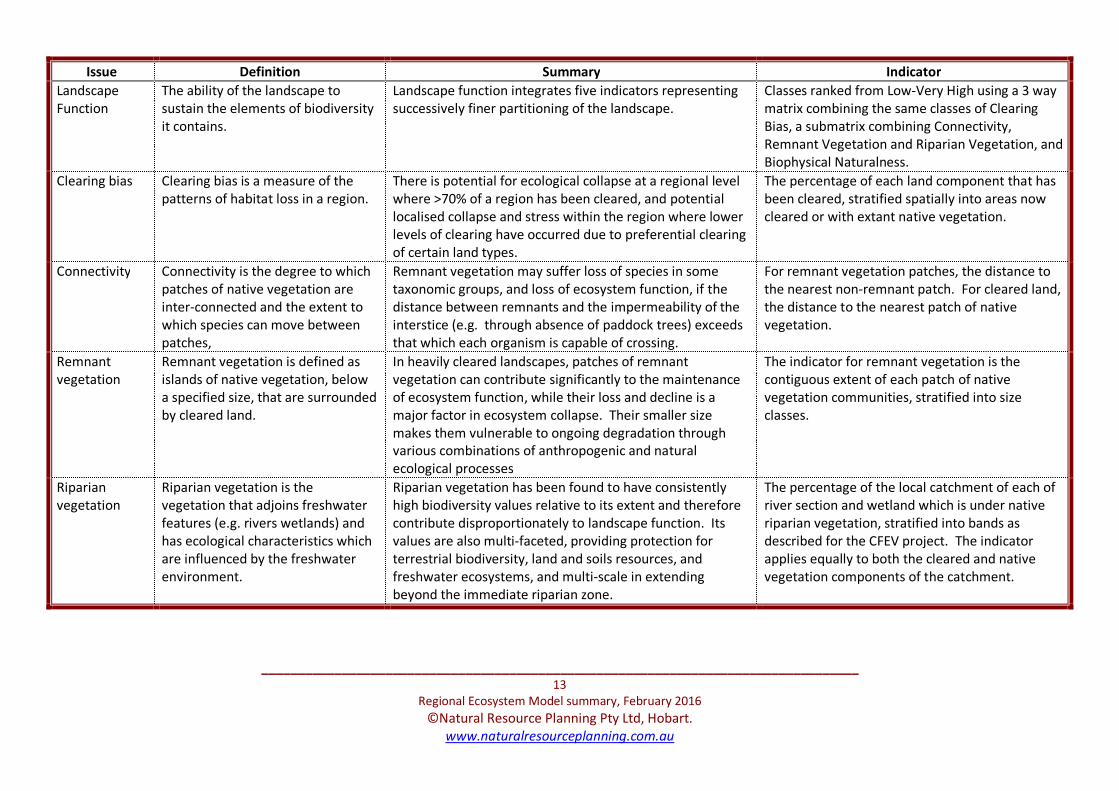
__________________________________________________________________________________
13
Regional Ecosystem Model summary, February 2016
©Natural Resource Planning Pty Ltd, Hobart.
www.naturalresourceplanning.com.au
Issue Definition Summary Indicator
Landscape
Function
The ability of the landscape to
sustain the elements of biodiversity
it contains.
Landscape function integrates five indicators representing
successively finer partitioning of the landscape.
Classes ranked from Low-Very High using a 3 way
matrix combining the same classes of Clearing
Bias, a submatrix combining Connectivity,
Remnant Vegetation and Riparian Vegetation, and
Biophysical Naturalness.
Clearing bias Clearing bias is a measure of the
patterns of habitat loss in a region.
There is potential for ecological collapse at a regional level
where >70% of a region has been cleared, and potential
localised collapse and stress within the region where lower
levels of clearing have occurred due to preferential clearing
of certain land types.
The percentage of each land component that has
been cleared, stratified spatially into areas now
cleared or with extant native vegetation.
Connectivity Connectivity is the degree to which
patches of native vegetation are
inter-connected and the extent to
which species can move between
patches,
Remnant vegetation may suffer loss of species in some
taxonomic groups, and loss of ecosystem function, if the
distance between remnants and the impermeability of the
interstice (e.g. through absence of paddock trees) exceeds
that which each organism is capable of crossing.
For remnant vegetation patches, the distance to
the nearest non-remnant patch. For cleared land,
the distance to the nearest patch of native
vegetation.
Remnant
vegetation
Remnant vegetation is defined as
islands of native vegetation, below
a specified size, that are surrounded
by cleared land.
In heavily cleared landscapes, patches of remnant
vegetation can contribute significantly to the maintenance
of ecosystem function, while their loss and decline is a
major factor in ecosystem collapse. Their smaller size
makes them vulnerable to ongoing degradation through
various combinations of anthropogenic and natural
ecological processes
The indicator for remnant vegetation is the
contiguous extent of each patch of native
vegetation communities, stratified into size
classes.
Riparian
vegetation
Riparian vegetation is the
vegetation that adjoins freshwater
features (e.g. rivers wetlands) and
has ecological characteristics which
are influenced by the freshwater
environment.
Riparian vegetation has been found to have consistently
high biodiversity values relative to its extent and therefore
contribute disproportionately to landscape function. Its
values are also multi-faceted, providing protection for
terrestrial biodiversity, land and soils resources, and
freshwater ecosystems, and multi-scale in extending
beyond the immediate riparian zone.
The percentage of the local catchment of each of
river section and wetland which is under native
riparian vegetation, stratified into bands as
described for the CFEV project. The indicator
applies equally to both the cleared and native
vegetation components of the catchment.

__________________________________________________________________________________
14
Regional Ecosystem Model summary, February 2016
©Natural Resource Planning Pty Ltd, Hobart.
www.naturalresourceplanning.com.au
Issue Definition Summary Indicator
Vegetation
condition
Vegetation condition is the
composition and structure of native
vegetation relative to a reference
framework for the particular type of
vegetation.
Vegetation condition is an indicator of the ability of native
vegetation at the local physical and near-temporal scale to
maintain and sustain the elements of biodiversity it
contains.
Modified biophysical naturalness classes derived
from RFA mapping and application of logical
consistency rules to Tasveg community
attributions and limited condition descriptors.

__________________________________________________________________________________
- 15 -
Regional Ecosystem Model summary, February 2016
©Natural Resource Planning Pty Ltd, Hobart.
www.naturalresourceplanning.com.au
Component
Cleared
(%)
Concern –
Immediate
Concern –
Potential
Cleared
>90% VH L
70-90% H L
30-70% M L
<30% L L
Native veg.
>90% VH VH
70-90% H H
30-70% M M
<30% L L
Biophysical
naturalness category
Concern –
Immediate
Concern –
Potential
5 (highest) L VH
4 L VH
3 M H
2 H M
1 (lowest) VH M
0 (non-native) L L
-1 (water, sand, mud) na na
River section
catchment or wetland
riparian vegetation (%)
Concern –
Immediate
Concern –
Potential
<1 VH L
1-20% H VH
20-80% M H
>80% L M
Native vegetation
patch size (ha)
Concern –
Immediate
Concern –
Potential
<2ha M L
2-20ha VH VH
20-200ha H VH
>200ha L M
Concern – Immediate & Potential
Reservation level (Min. % State/bioreigon)
Status and bioreg.
extent <10% 10-30% 30-60% >60%
Threatened
Any VH VH H H
Not threatened
Bioregional extent
<2,000ha VH VH H M
2,000-5,500ha VH VH H M
5,500-15,000ha VH H M L
15,000-55,000ha H M M L
>55,000ha M M L L
Distance of: Concern –
Immediate
Concern –
Potential
Cleared land
to native veg.
<50m L L
50-250m M L
250-1,000m H L
>1,000m VH L
Native
remnant to
non-remnant
<50m L VH
50-250m M H
250-1,000m H M
>1,000m VH L
Non-remnant
Any L L
Species
category/
attribute
Concern –
Immediate
Concern –
Potential
Two or more
listed species VH VH
Endangered,
Critically
Endangered
VH VH
Vulnerable,
Rare H H
Other priority
species M M
None L L
Descriptor of hollow
probability (eucalypt
forest only)
Concern –
Immediate
Concern –
Potential
Old growth forest L VH
Mature; Predominantly
Mature, Some Regrowth
M H
Predominantly
Regrowth, Some Mature
H M
Regrowth, Silvicultural
Regeneration
VH L
All other vegetation L L
Hollow Dwelling Species Habitat
Threatened & Other
Priority Species VH H M L
Two or more listed
species VH VH VH VH VH
Endangered, Critically
Endangered
VH VH VH VH VH
Vulnerable, Rare H VH H H H
Other Priority Species M H H M M
None L H M L L
Priority Species Index
Native
Vegetation Index
VH
H
M
L
VH VH VH VH VH
H VH VH H H
M VH H M M
L VH H M L
Landscape Function Index
Biological
Significance
Index
VH H M L
VH VH VH VH VH
H VH VH H H
M VH H M M
L VH H M L
Biodiversity
Management Priority (Immediate &
Biological Significance Index (Importance = 1)
Landscape Function Index (Importance = 1)
Priority Species Significance* (Importance = 1)
Vegetation Conservation Status (Importance = 1)
Threatened species (Importance = 1)
Other priority species (Importance = 2)
Hollow dwelling habitat (Importance = 2)
Old growth Forest (Importance = 1)
Eucalypt forest structure (Importance = 2)
Other vegetation (Importance = 3)
Threatened communities (Importance = 1)
Relative reservation (Importance = 2)
Relative rarity (Importance = 3)
Clearing bias (Importance = 1)
Connectivity# (Importance = 2)
Remnant vegetation# (Importance = 2)
Riparian vegetation# (Importance = 2)
Vegetation condition (Importance = 3)
Forest Practices
Authority -
predicted hollow
abundance
Concern –
Immediate
Concern –
Potential
High L VH
Medium M H
Low H M
Not rated L L
Attachment 2. Tasmanian Regional Ecosystem Model - Indicators, Content & Prioritisation Matrices
See next page

__________________________________________________________________________________
16
Regional Ecosystem Model summary, February 2016
©Natural Resource Planning Pty Ltd, Hobart.
www.naturalresourceplanning.com.au
Attachment 2 (cont). Derivation of Landscape Function Index
Sub-matrix of Connectivity, Remnant Vegetation & Riparian Vegetation (CRR) Full Landscape Function Index matrix
Connectivity Remnant
Vegetation
Riparian
Vegetation
CRR
Index
Rank (1 =
highest)
VH VH VH VH 1
H VH VH VH 2
VH VH H VH 3
VH H VH VH 4
M VH VH VH 5
H VH H VH 6
VH VH M VH 7
H H VH VH 8
VH H H VH 9
VH M VH VH 10
L VH VH H 11
M VH H H 12
H VH M H 13
VH VH L H 14
M H VH H 15
VH H M H 16
H M VH H 17
VH M H H 18
VH L VH H 19
L VH H H 20
M VH M H 21
H VH L H 22
L H VH H 23
VH H L H 24
M M VH H 25
VH M M H 26
H L VH H 27
VH L H H 28
L VH M H 29
M VH L H 30
L M VH H 31
VH M L H 32
M L VH H 33
Connectivity Remnant
Vegetation
Riparian
Vegetation
CRR
Index
Rank (1 =
highest)
VH L M H 34
H H H H 35
M H H M 36
H H M M 37
H M H M 38
L VH L M 39
L L VH M 40
VH L L M 41
L H H M 42
M H M M 43
H H L M 44
M M H M 45
H M M M 46
H L H M 47
L H M M 48
M H L M 49
L M H M 50
H M L M 51
M L H M 52
H L M M 53
L H L M 54
L L H M 55
H L L M 56
M M M L 57
L M M L 58
M M L L 59
M L M L 60
L M L L 61
L L M L 62
M L L L 63
L L L L 64
Clearing
Bias
CRR sub-
matrix Condition
Landscape
Function
Index
Rank
(1 = highest)
VH VH VH VH 1
VH VH H VH 2
VH H VH VH 3
VH VH M VH 4
VH H H VH 5
VH VH L VH 6
H VH VH VH 7
VH M VH VH 8
VH H M VH 9
H VH H VH 10
VH M H VH 11
VH H L VH 12
H H VH VH 13
H VH M VH 14
VH L VH VH 15
VH M M VH 16
H H H H 17
H VH L H 18
M VH VH H 19
VH L H H 20
VH M L H 21
H M VH H 22
H H M H 23
M VH H H 24
VH L M H 25
H M H H 26
H H L H 27
M H VH H 28
M VH M H 29
VH L L M 30
H L VH H 31
H M M H 32
M H H M 33
Clearing
Bias
CRR sub-
matrix Condition
Landscape
Function
Index
Rank
(1 = highest)
L VH VH M 34
M VH L M 35
H L H M 36
H M L M 37
M M VH M 38
M H M M 39
L VH H M 40
H L M M 41
M M H M 42
M H L M 43
L H VH M 44
L VH M M 45
H L L M 46
M L VH M 47
M M M M 48
L H H L 49
L VH L M 50
M L H L 51
M M L M 52
L M VH L 53
L H M L 54
M L M L 55
L M H L 56
L H L L 57
M L L L 58
L L VH L 59
L M M L 60
L L H L 61
L M L L 62
L L M L 63
L L L L 64

__________________________________________________________________________________
17
Regional Ecosystem Model summary, February 2016
©Natural Resource Planning Pty Ltd, Hobart.
www.naturalresourceplanning.com.au
Attachment 3:
A simple guide to using the
Regional Ecosystem Model for biodiversity planning
The REM contains assessments of four attributes of biodiversity that may need to be
considered for conservation:
• Native vegetation (Tasveg-based units assessed Statewide and bioregionally);
• Priority species (threatened and other important species);
• Hollow dwelling species habitat; and
• Landscape ecological function – the ability of the landscape to maintain the
elements of biodiversity it contains.
Actions may range from retention in an existing state, rehabilitation to a better state or
restoration of native vegetation. Actions can be guided by the REM classification of
attributes from two prioritisation perspectives:
• Immediate – importance for intervention to restore or rehabilitate; and
• Potential – important to protect from further loss or degradation.
In the REM these are termed ‘Level of Concern’. All REM Level of Concern attributes are
rated on a scale of Low, Medium, High or Very High. Immediate and Potential priorities are
identical for native vegetation and priority species, but are different for hollow dwelling
species habitat and landscape ecological function.
Priorities to be assigned to any of the REM attributes will be heavily influence by the purpose
and objectives being considered and the adequacy of resources to effect desired outcomes.
REM priorities can also be considered on an entirely objective basis, and used to judge
whether objectives and resources are appropriately targeted, adequate to achieve
outcomes. Monitoring over time can also be facilitated by the REM.
Prioritising areas or actions may require consideration of any of the four key attributes
either singly or in combination. The potential range of combinations is large. However, for
regions which are relatively intensively developed a fairly consistent set of combinations can
be identified, particularly through focusing on priorities classified as either High or Very High.
These are identified in the table that follows.

__________________________________________________________________________________
18
Regional Ecosystem Model summary, February 2016
©Natural Resource Planning Pty Ltd, Hobart.
www.naturalresourceplanning.com.au
REM attribute
(High or Very
High)
Co-occurring
attributes
Key considerations
Native
vegetation
Priority
species
Actions will depend on individual species’ conservation needs.
Landscape
function –
Potential
Landscape has some sensitivity to further loss or degradation. Action to
protect the vegetation should be considered.
Landscape
function –
Immediate
Landscape function is degraded. Consider whether actions to protect or
enhance the native vegetation can make a difference.
None Consider if there are potential threats or other benefits that would arise
from intervention. Also consider if there is a residual reservation target
for the vegetation community and whether a good example of the
community would be secured.
Priority species None Consider the conservation needs of each individual species individually.
Landscape
function –
Potential
Landscape is sensitive to further loss or degradation. Consider whether
this might have negative effects on each species.
Landscape
function –
Immediate
Landscape function is degraded. Consider if landscape characteristics are
contributing to the species status or likely persistence.
Hollow dwelling
species habitat –
Immediate
None Vegetation is lacking in hollows. Look at the landscape context to
determine if there is a likely benefit from taking actions which would
improve long term prospects to have adequate mature eucalypt
abundance, e.g. is the area a gap in distribution. The primary attribute
field [Vstr_clasZ] should be used for this.
Hollow dwelling
species habitat –
Potential
None Mature eucalypt abundance is likely to be relatively high. Act to protect
and enhance, especially if either Immediate or Potential landscape
ecological function classes are high.
Landscape
function –
Immediate
None Landscape function is degraded. Consider what aspects of can be
improved – condition, patch size, riparian vegetation or connectivity –
within the available resources. The spreadsheet version of the REM can
be used to explore scenarios.
Landscape
function -
Potential
None Landscape function is sensitive to further loss or degradation. Consider
what action can be take to secure landscape attributes.
Landscape
function –
Immediate
Landscape
function -
Potential
These are generally more important remnants. Consider whether
resources are sufficient to both secure and improve landscape attributes.

68
Appendix B
Agricultural Zone Assessment
Meander Valley Council Local Provisions Schedule December 2017
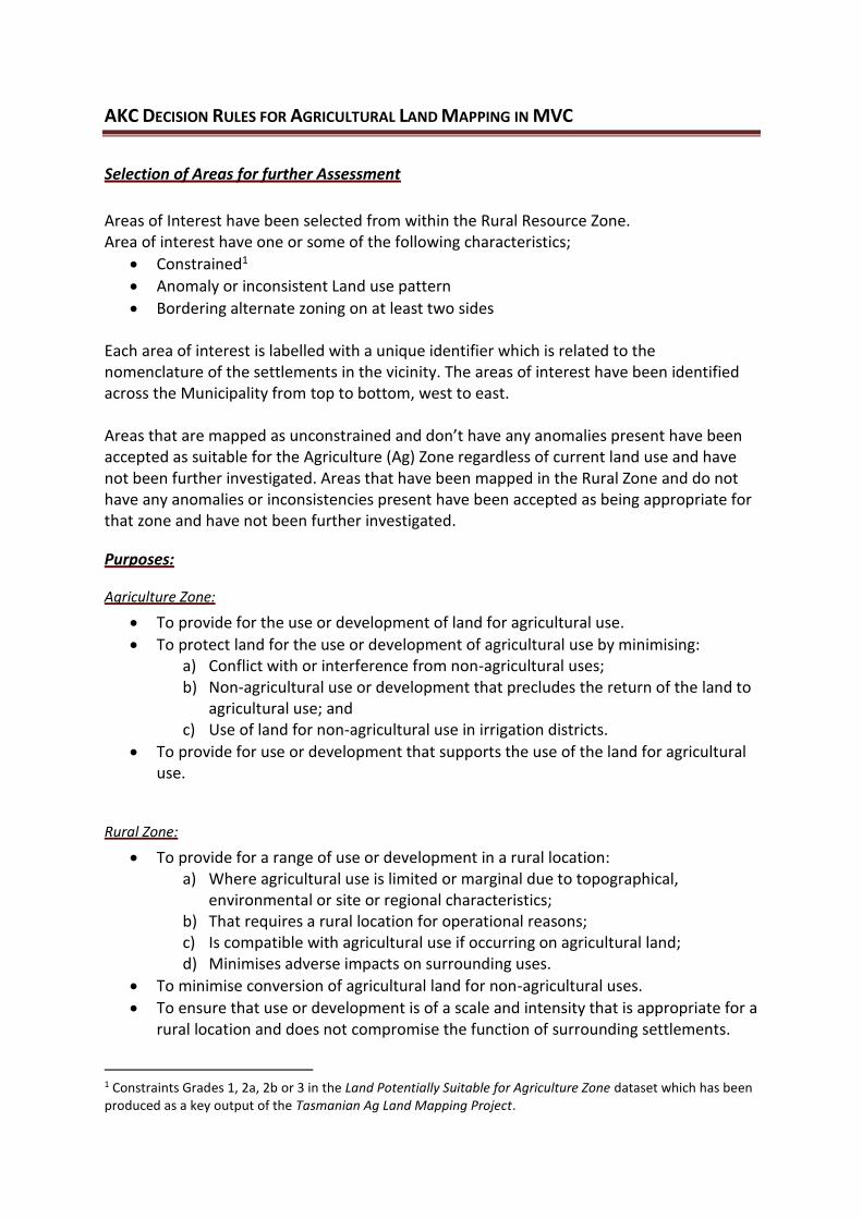
AKC DECISION RULES FOR AGRICULTURAL LAND MAPPING IN MVC
Selection of Areas for further Assessment
Areas of Interest have been selected from within the Rural Resource Zone. Area of interest have one or some of the following characteristics;
• Constrained1
• Anomaly or inconsistent Land use pattern
• Bordering alternate zoning on at least two sides Each area of interest is labelled with a unique identifier which is related to the nomenclature of the settlements in the vicinity. The areas of interest have been identified across the Municipality from top to bottom, west to east. Areas that are mapped as unconstrained and don’t have any anomalies present have been accepted as suitable for the Agriculture (Ag) Zone regardless of current land use and have not been further investigated. Areas that have been mapped in the Rural Zone and do not have any anomalies or inconsistencies present have been accepted as being appropriate for that zone and have not been further investigated.
Purposes:
Agriculture Zone:
• To provide for the use or development of land for agricultural use.
• To protect land for the use or development of agricultural use by minimising: a) Conflict with or interference from non-agricultural uses; b) Non-agricultural use or development that precludes the return of the land to
agricultural use; and c) Use of land for non-agricultural use in irrigation districts.
• To provide for use or development that supports the use of the land for agricultural use.
Rural Zone:
• To provide for a range of use or development in a rural location: a) Where agricultural use is limited or marginal due to topographical,
environmental or site or regional characteristics; b) That requires a rural location for operational reasons; c) Is compatible with agricultural use if occurring on agricultural land; d) Minimises adverse impacts on surrounding uses.
• To minimise conversion of agricultural land for non-agricultural uses.
• To ensure that use or development is of a scale and intensity that is appropriate for a rural location and does not compromise the function of surrounding settlements.
1 Constraints Grades 1, 2a, 2b or 3 in the Land Potentially Suitable for Agriculture Zone dataset which has been produced as a key output of the Tasmanian Ag Land Mapping Project.

Decision Rules
Decision rules have been based on a conservative approach, with all areas of interest first being considered for their suitability for being included in the Ag Zone before suitability for inclusion in Rural Zone is considered. This method also provides the potential for titles previously mapped in the Rural Resource Zone that have not been included in the State-wide Ag Mapping Projects Ag Estate to be included in the Ag Zone if deemed more appropriate.
• For titles being assessed the following characteristics are considered: o Ag Mapping Assessment potential constraint category or none Ag areas o Size (ha) o Ownership (individual or with adjacent or nearby titles) o Ag activities o Enterprise Suitability o Irrigation water resources (existing and potential) o Enterprise scale (lifestyle, hobby, commercial) o Remoteness - distance to market, labour, contractors and support services o Natural values o Existing dwelling o Onsite reserve o Adjacent reserve o Adjacent land use. o Adjacent tenure
These characteristics provide a snapshot of a title’s agricultural capacity and potential constraints. This will provide a strong indication as to the zone a title is most suited to. Whilst some of these characteristics were included in the Ag land mapping project, the majority of the analysis was undertaken as a GIS exercise. In this more detailed analysis local knowledge and context is applied in a case by case assessment rather than a GIS analysis. As part of this analysis Enterprise Scale of holdings analysed was assessed. Enterprise Scale analysis and the associated definitions was first developed in 2012 for Northern Tasmania Development in response to a request for clarification of the methodologies and tools and their application in understanding agricultural potential for planning purposes. A range of characteristics including current enterprise activities, Land Capability and irrigation water resources are analysed at the holding level which enables titles to be categorised into three broad categories; ‘commercial scale farms’, ‘hobby farms’ and ‘lifestyle blocks’2.
2 Adapted from Ketelaar, A and Armstrong, D. 2012, Discussions paper – Clarification of the Tools and Methodologies and Their Limitations for Understanding the Use of Agricultural Land in the Northern Region - written for Northern Tasmania Development.

Decision Rule Rationale
Consistency of land use patterns Titles that have characteristics that are suitable for either the Rural or Ag Zone (based on State – Zone Application
Framework Criteria) will be zoned based on surrounding titles with the chief aim of providing a consistent land use
pattern.
Minimum of three titles (where feasible) to
make a zone where feasible
To avoid spot zoning of individual titles it was determined that a minimum of 3 title to be investigated (depending on
size and scale of titles) for a zone which will work towards providing a more consistent zoning pattern.
Resource Development activities should
not go in Environmental Management
Zone
The purpose of the Environmental Management Zone is to provide for the protection and conservation of land with
significant ecological, scientific, cultural or scenic values. Hence resource development activities should be more
appropriately zoned Rural where resource development is prioritised or if on land with agricultural potential then be
zoned Ag.
Plantation or native vegetation can be
zoned either Ag or Rural
Non-Ag development is permitted in both the Rural & Ag Zone. However, the Ag Zone has stricter provisions as to the
site that none agricultural activities can occur on. Zoning will aim to reflect a consistent land use pattern.
Prime Agricultural land may be considered
for alternate zoning from Ag Zone if
significantly constrained
Prime Agricultural Land (Land Capability Class 1, 2, 3) as a default rule has been included in the Ag Zone. However,
there may be instances where this land is significantly constrained by adjacent land use and localised characteristics.
In these instances, alternate zoning will be considered.
Adjacent titles owned by same entity to be
included in the same zone when possible
Adjacent titles under same ownership are most likely farmed in conjunction. By zoning these titles under same zone
land holders will have consistency of Planning Scheme permitted uses. However, current land use practices will also
be considered as there may be instances where titles under same ownership are utilised for differing land uses which
are more appropriately zoned differently. This will also potentially be the case for larger titles where split zoning might
be appropriate. Plantations on land famed in conjunction with mixed farming operations are more likely to be
converted to an alternative agricultural use. Hence if the majority of the holding is in the Ag zone then the preference
would be for the title supporting plantation to also be in the Ag zone.
Split zoning of titles to only occur in
exceptional circumstances
Split zoning is only to occur on titles that have significantly divergent agricultural potential. This will generally only
occur on larger titles.
Mapped potentially constrained titles to be
zoned Ag if surrounding adjacent land use
is commercial scale agriculture.
The purpose of the Ag Zone is to identify and protect Tasmania’s agricultural land. By zoning adjacent potentially
constrained titles as Ag, these titles will ensure the potential proposed future uses that could further constrain ag
activities will be limited.

Agricultural enterprises with commercial
scale characteristics to go into Ag Zone
unless significantly constrained by
surrounding uses
The purpose of the Ag Zone is to identify and protect Tasmania’s agricultural land. Title with Commercial scale
characteristics are to be prioritised for the Ag Zone to provide optimal Planning Scheme protection. However, in a
situation where the commercial scale characterisitics are anomalous to surrounding land uses and zoning, with limited
potential for expansion, it is likely that an alternate zone will be more appropriate to ensure zoning pattern
consistency.
If a Mining Lease occurs on a title being
assessed then the preferred zoning is Rural
Extractive Industry is a permitted use in the Rural Zone, but is discretionary in the Ag Zone. By zoning as Rural, land
owners will have greater certainty relating to extractive industry than would be the case if zoned Ag. However,
location, size and surrounding land uses will also be considered to ensure a consistent zoning pattern that reflects the
predominate use.
If there are significant existing irrigation
water resources or potential for developing
irrigation water resources the preferred
zoning for the area of interest is Ag
Irrigation water resources are integral to agricultural productivity, diversifying and risk management. Although the Ag
mapping project erred on the side of caution for retaining irrigation water resources in the Ag zone, this factor needs
to be reconsidered to include potential for on-farm storage when examining constrained areas of interest.
Titles utilised for resource processing will
be zoned Rural where appropriate
Resource processing is a permitted use in the Rural Zone, but is discretionary in the Ag Zone. By zoning as Rural, land
owners will have greater certainty relating to resource processing than would be the case if zoned Ag. However,
location, size and surrounding land uses will also be considered to ensure a consistent zoning pattern that reflects the
predominate use.
Titles with significant natural values
(including karst) will be recommended for
an alternate zone to Ag, if the natural
values places constraints on the
agricultural potential of the land.
The purpose of the Ag Zone is to prioritise the protection of Ag land. However, if it is deemed that the future ag
potential of an area is constrained due existing natural values, then an alternate zone might be more appropriate.
Titles with existing Private Timber Reserves
(PTRs) will be assessed to be included in
Rural Zone
Any PTR owned by a commercial forestry company that has a PTR that is attached and contiguous to proposed Rural
Zone will be included in Rural Zone. Then if other PTRs are also attached and contiguous with Rural Zone they will also
be considers for Rural Zone. Surrounding titles with Rural characteristics will also be included in Rural Zone if it
provides more appropriate zoning consistency and continuity.

If an alternate zone to Ag or Rural is
considered more appropriate for an area
then the area will be flagged for Council to
further consider
There may be instances where an alternate zone to Ag or Rural is considered more appropriate due to existing land
use, surrounding land use, zoning and constraints. In these instances, the area will be flagged for Council to further
consider alternate Zones.

Meander Valley Agriculture Zone AnalysisMeander Valley Agriculture Zone Analysis
Base data from theLIST, © State of TasmaniaLand title data current as of
´0 2 4 6 8 10
Kilometres
Prepared by:
Map Scale 1 : 85,000 when printed at A0
Coordinate System: GDA94 MGA zone 55
Map Date: 29/8/2017
Legend
Land Title
Potential Suitability for the Agriculture Zone
Land Potentially Suitable for the Agriculture Zone (Unconstrained)
Land Potentially Suitable for the Agriculture Zone (Constrained Criteria 2A)
Land Potentially Suitable for the Agriculture Zone (Constrained Criteria 2B)
Land Potentially Suitable for the Agriculture Zone (Constrained Criteria 3)
Stage 2 Rural Titles
Private Timber Reserves
Commercial Forestry
Forestry Tas

69
Appendix C
Zone Comparison
Meander Valley Council Local Provisions Schedule December 2017
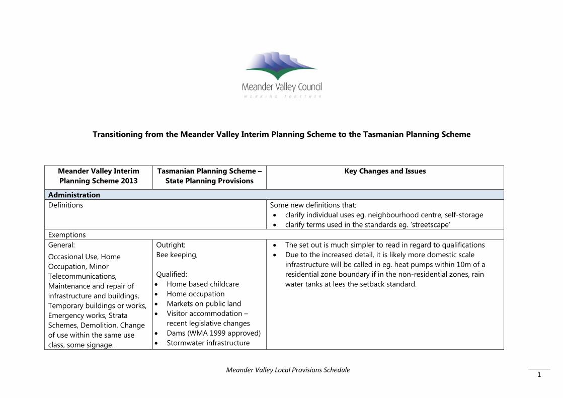
1
Transitioning from the Meander Valley Interim Planning Scheme to the Tasmanian Planning Scheme
Meander Valley Interim Planning Scheme 2013
Tasmanian Planning Scheme – State Planning Provisions
Key Changes and Issues
Administration Definitions Some new definitions that:
• clarify individual uses eg. neighbourhood centre, self-storage • clarify terms used in the standards eg. ‘streetscape’
Exemptions General: Occasional Use, Home Occupation, Minor Telecommunications, Maintenance and repair of infrastructure and buildings, Temporary buildings or works, Emergency works, Strata Schemes, Demolition, Change of use within the same use class, some signage.
Outright: Bee keeping, Qualified: • Home based childcare • Home occupation • Markets on public land • Visitor accommodation –
recent legislative changes • Dams (WMA 1999 approved) • Stormwater infrastructure
• The set out is much simpler to read in regard to qualifications • Due to the increased detail, it is likely more domestic scale
infrastructure will be called in eg. heat pumps within 10m of a residential zone boundary if in the non-residential zones, rain water tanks at lees the setback standard.
Meander Valley Local Provisions Schedule

2
Limited - dependent upon heritage controls, native vegetation removal controls, scenic management areas, potential for contaminated land, salinity or landslip hazard, threatened vegetation, proximity to watercourse, frontage setbacks, dimensions of buildings: Minor structures and outbuildings, upgrades of linear and minor utilities/infrastructure, Vegetation clearance, Fences, Agricultural buildings.
• Irrigation pipes in Rural or Agriculture Zones
• Road works, bridges and level crossings
• Minor telecommunications • Minor infrastructure • Navigation aids • Electric car rechargers • Emergency works • Internal works, minor
alteration, maintenance and repair (if not State heritage listed)
• Temporary buildings or works
• Unroofed decks • Outbuildings (variable zone
requirements) • Demolition • Garden structures • Vegetation removal • Renewable energy • Signs • Use of a road reserve or
public land • Fences and retaining walls • Land filling • Minor infrastructure –
antennas, masts, heat pumps (setbacks requirements), hot
Meander Valley Local Provisions Schedule

3
water cylinders, water tanks, fuel tanks, anemometers
• Strata schemes 6.2 and 7.10 Categorising Use or Development Removes the requirement to define a use for subdivision, signs, land
filling, retaining walls or coastal protection and prescribes assessment criteria for discretionary development.
6.11 Conditions and Restrictions on a Permit Has added the ability to condition for issues related to construction, traffic management and stormwater management for erosion, volume and water quality. Note: This has since been significantly limited by changes to s.9 of the Building Act which prevents a planning permit from including conditions that relate to technical building components, such as stormwater matters that are the jurisdiction of the plumbing regulations.
7.4 Change of Use of a State of Local heritage listed site New provision - Allows for prohibited uses to be considered as discretionary for any heritage listed site where that use facilitates the conservation and maintenance of the heritage asset. Provides an incentive to promote heritage and re-use of buildings.
7.12 Sheds on vacant sites Sets out permitted status standards for Low Density Residential, Rural Living and Landscape Conservation zones: • 1 only • Meets setbacks • Future dwelling can be built between shed and front setback • Wall height 4m, overall height 6m • Floor area 54m2 • Complies with codes
Meander Valley Local Provisions Schedule

4
General Residential Zone Use
NPR: Residential – single dwelling Natural and cultural values management Passive recreation Permitted: Residential Minor utilities Discretionary: Bulky Goods Sales (27 Tower Hill St) Business and professional services – medical centre Community Meeting and Entertainment – not function centre, cinema Educational and occasional care Equipment and machinery sales and hire (27 Tower Hill St) Food services – café/takeaway food & 27 Tower Hill St
NPR: Residential – single dwelling Natural and cultural values management Passive recreation Minor utilities Permitted: Residential Visitor Accommodation Discretionary: Business and Professional Services (consulting room, medical centre, veterinary centre, child health clinic, residential support services) Community Meeting and Entertainment Educational and Occasional Care – not tertiary Emergency Services Food Services General Retail and Hire
• Visitor Accommodation as a permitted use will be controversial, though is limited to existing buildings and 300m2.
• This is outside the government’s exemption for 4 bedrooms and principal residence.
Meander Valley Local Provisions Schedule

5
General retail and hire- local shop Service Industry (27 Tower Hill St) Storage (27 Tower Hill St) Visitor accommodation Utilities
Sports and Recreation Utilities
Development Standards • Planning Directive 4.1 –
Single and Multiple Dwellings
• Residential buildings – communal
• Non-residential development – performance criteria only
• Minor modifications to PD4.1 – no window orientation
• All residential use is classed as a dwelling
• Measurable standards for non-dwelling development
No significant changes – density of all types of residential forms are assessed for site coverage and building envelope.
Subdivision • General Suitability –
Discretionary • Min lot size – 700m2 • Min frontage 4m • Reticulated services • Solar orientation • Road network and
connectivity • Services – allowances for
areas without connection to full water, sewer and stormwater services.
• Min lot size – 450m2 • Min frontage 12m • Vehicular access • Solar orientation • Road network and
connectivity • Water – min connection to a
limited service • Sewer – mandatory
connection to reticulated system
• Stormwater – allowance for
• Permitted status for subdivision if it can meet the standards. • Internal lots will almost always be discretionary due to 12m
frontage standards. • Mandatory requirement for sewer connection is unlikely to limit
development.
Meander Valley Local Provisions Schedule

6
on-site Low Density Residential Zone Use
NPR: Natural and cultural values management Passive recreation Residential – single dwelling Permitted: Minor utilities Discretionary: Business and professional services – medical Emergency services General retail and hire (local shop) Community meeting & entertainment Residential (communal residence –Glendel Homes) Resource processing (Burns woodyard at Arthur St) Sports and recreation Visitor accommodation Utilities
NPR: Natural and Cultural Values Management Passive Recreation Residential Utilities Permitted: Visitor Accommodation Discretionary: Business and Professional Services (consulting room, medical centre, veterinary centre, child health clinic, residential support services) Community Meeting and Entertainment Educational and Occasional Care (not tertiary) Emergency Services Food Services General Retail and Hire (local shop)
• Visitor Accommodation as a permitted use may be controversial, though is limited to existing buildings and 300m2.
• This is outside the government’s exemption for 4 bedrooms and principal residence.
• Remove reference to communal residence for Glendel Homes site • Allows for multiple dwellings, although at subdivision densities. • Introduces additional uses for Educational and Occasional Care,
Food Services and expands business and professional uses. • An amenity clause is included for discretionary uses.
Meander Valley Local Provisions Schedule

7
Residential Sports and Recreation Utilities
Development Standards • Site Coverage – 30% • Height – 8m • Front setback – 6m, 3m
secondary frontage • Side boundary setback -
3m • Rear boundary setback –
5m • Outbuildings: 80m2, 3.5m
wall height, 4.5m height • Non-residential
development – performance criteria only
• Site Coverage – 30% • Height – 8.5m • Frontage – 8m • Side and rear boundary
setback – 5m • Frontage fences within 4.5m
of boundary – 1.2m solid/1.8m with 50% transparency exempt, otherwise discretionary
• Non dwelling development – only additional clauses relate to outdoor storage and 10m setback for mechanical plant
• More open in regard to potential outbuilding sizes – can only be managed by site coverage. Consider specific provisions associated with larger lots (refer subdivision comments below)
• Clarifies fence status
Subdivision • General Suitability –
Discretionary • Min lot size – Variable
sizes:
Blackstone Heights
1600m2
Westbury 5000m2
• Min lot size 1500m2 • Min frontage 20m • Vehicle access • Road network and
connectivity • Services
• There is a significant issue regarding the 1500m2 minimum lot size when considering whether this zone is suitable for transitioning to the Tasmanian Planning Scheme. The current Interim Planning Scheme applies the zone with same general intent in regard to use and the primary purpose of the zone for residential use, however is located in areas where the more urban lot size of 1500m2 will not be suitable for localities other than Blackstone Heights.
• All areas currently zoned Low Density Residential Zone have a lot
Meander Valley Local Provisions Schedule

8
Deloraine 5000m2 Chudleigh 5000m2 Exton 5000m2 Elizabeth Town 1ha Kimberley 5000m2 Meander 1ha Davis Road 1ha Hadspen (flood area),Pumicestone Ridge, Travellers Rest
No additional lots
• Prohibits subdivision at
Hadspen (flood area), Pumicestone Ridge, Travellers Rest.
• 35m metre circle dimension
• Min frontage 4m • Services – allowances for
areas without connection to full water, sewer and stormwater services.
size that provides for intensification of dwellings at a level considered appropriate to reflect that community’s desired character and the more limited capacity of more remote roads and services, or is prohibited by the lack of capacity for that locality to densify due environmental/service constraints.
• Rural Living Zoning as an alternative, is not considered suitable as: - it provides for additional uses that are potentially higher
impact (resource development, resource processing, vehicle fuel sales and service) reflective of the zone purpose and the larger lot size range;
- The lowest lot size available is 1ha, with an absolute minimum of 8000m2, which does not provide appropriate opportunity to maximise lot yields; and
- Rural Living areas are not of the same character as the current Low Density Residential zones.
• As there is no zone available in the SPP’s that appropriately provides for the preferred character through the use table and development density provisions, it is recommended that Specific Area Plans are prepared for all existing zoned areas (except for Blackstone Heights) that carry forward the current lot sizes (including prohibitions) and the outbuilding limitations (noting that Council’s response to representations to the IPS resolved to increase size allowances for outbuildings).
• Travellers Rest: The current Low Density Residential Zone at Travellers Rest is also subject to an important scenic management overlay that manages the visual impacts of development, particularly vegetation clearance, as the hill is very prominent in the landscape when viewed from the Bass Highway. The SPP’s remove the ability to apply a scenic management overlay to the Low Density
Meander Valley Local Provisions Schedule

9
Residential Zone. As such, another approach that maintains the objectives of the current area will need to be considered. Relevant matters will include whether the zone reflects the primary intention for land use, the effect on existing use rights and the requirement for justification under 34(2) of the Act. Options that could be considered that allow the scenic protection overlay to be carried forward are the Landscape Conservation Zone, the Rural Living Zone or a Particular Purpose Zone. At face value, the Landscape Conservation Zone would appear to reflect the objectives for the area most closely, however the principal difference is that new dwellings would be a discretionary use, which is different to the discretion currently applied by the Scenic Management overlay. This would be a reduction in use entitlement from the current situation as residential use is currently not questioned as a primary use (NPR), it is more about how development is located that is considered in the discretion. It is noted that this zone provides for permitted status single dwellings where a building area is shown on a sealed plan, which is an effective mechanism for new subdivision, however does not assist at Travellers Rest as the area is fully subdivided with no real potential for any additional lots, though still has numerous vacant lots. The principal of prioritising single dwellings is ‘up-front’ however. The provisions of the zone can be modified or extended through SSQ’s or SAP’s. A SSQ cannot be applied in this instance as it relates to a number of lots, however a SAP could be defined around the current LDR zone boundary which generally carries
Meander Valley Local Provisions Schedule

10
forward the current entitlements and restrictions by classing single dwellings as either permitted/no permit required and prohibiting Resource Development Use. It is recommended that this approach is pursued through the LPS.
Rural Living Zone Use
NPR: Natural and cultural values management Passive recreation Permitted: Business and professional services (veterinary services) Residential (single dwelling) Resource development (grazing) Minor Utilities Discretionary: Business and professional services Community meeting & entertainment Domestic animal breeding, boarding or training
NPR: Natural and Cultural Values Management Passive Recreation Residential (single dwelling) Resource Development (grazing) Minor Utilities Permitted: Visitor Accommodation Discretionary: Business and Professional Services (veterinary services) Community Meeting and Entertainment (church, art/craft centre, public hall) Domestic Animal Breeding, Boarding and Training
• Visitor Accommodation as a permitted use may be controversial, though is limited to existing buildings and 300m2.
• This is outside the government’s exemption for 4 bedrooms and principal residence.
• Change to NPR for single dwellings if meets basic standards (loss of ability to condition for visual impact where vegetation is being removed)
• Some uses are more limited and can’t be considered against impact criteria eg. function centre for weddings in a garden/bush setting, field training schools, new respite services, new manufacturing beyond home business, intensive animal husbandry, indoor recreation facilities such as equestrian centre (MVC has a few of these), tourist operation.
• Not recommended for local variation.
Meander Valley Local Provisions Schedule

11
Educational and occasional care Food services General retail and hire Manufacturing and processing Resource development (not for forestry) Resource processing (not abattoir, saleyard, sawmill) Sports and recreation (not firing range, golf course, racecourse) Vehicle Fuel sales and Service ( Elizabeth Town Roadhouse) Visitor accommodation (not motel) Tourist operation Utilities (not wastewater or water treatment plant)
Education and Occasional Care (childcare, primary school, existing respite centre) Emergency Services Food Services (250m2) General Retail and Hire (primary produce sales, local shop) Manufacturing and Processing (existing only) Resource Development (not intensive animal husbandry or forestry) Resource Processing (not abattoir, saleyard, sawmill) Sports and Recreation (outdoor recreation facility) Utilities Vehicle Fuel Sales and Service
Development Standards • Site Coverage – 5% • Height – 8m • Frontage setback – 25m • Side boundary setback -
25m • Rear boundary setback –
25m • Setback for sensitive use
• Site Coverage – 400m2 • Height – 8.5m • Frontage – 20m • Side and rear boundary
setback – 10m • Setback for sensitive use to
Rural Resource Zone – 200m, or not less than
• The removal of the ability to consider vegetation removal for character objectives may result in obtrusive development, however it is not recommended for local variation at this stage.
Meander Valley Local Provisions Schedule

12
to Rural Resource Zone – 200m
• Development for discretionary use (character)
• Removal of trees (visual character)
existing building
Subdivision • General Suitability –
Discretionary • Min lot size – Variable
sizes: Reedy Marsh 15ha Birralee Chudleigh Elizabeth Town Liffey Lower Golden Valley Mole Creek Pateena Rd/Meander Valley Rd Rosevale Weetah
10ha
Davis Road Meander
4ha
Carrick As set out in F3 Carrick Rural Living Specific Area Plan, or
• Min lot size – Variable sizes:
Rural Living Zone A 1ha Rural Living Zone B 2ha Rural Living Zone C 5ha Rural Living Zone D 10ha
• Min frontage 40m • Vehicle access • Road network and
connectivity • Services for Rural Living
Zone A
• Minor differences in lot sizes will not result in a significant impact on character and can be transitioned to the LPS without local variation. It is noted however that the SPP’s include an absolute minimum reduction below the lot size of 20%, whereas the current scheme utilises tests against character objectives. This will limit yields compared to current potential.
• Recommended that areas currently designated 10-15ha are zoned Rural Living Zone D and areas currently designated 4ha are zoned Rural Living Zone C.
• Parkham – the qualification to prohibit subdivision for lots that front Parkham Road is no longer necessary as the absolute restriction in the performance criteria will prohibit any further creation of lots.
• The other areas that have been precluded from the creation of additional lots by subdivision were designated to achieve compliance with the RLUS. The LPS must also demonstrate compliance with the RLUS, which creates an obvious conflict with the SPP’s minimum lot sizes. There are three potential options: a) Adopt the largest lot size of area D for all which will enable
additional lot yield from the zone as follows:
Meander Valley Local Provisions Schedule

13
2ha – if not located within F3 Carrick Rural Living Specific Area Plan
Hadspen As set out in F2 Hadspen Specific Area Plan
Kimberley Red Hills Ugbrook Upper Golden Valley Weegena Western Creek Jackey’s Marsh
No additional lots created
• Min frontage 4m
Kimberley 12 lots Weegena 4 lots Red Hills 0 Lots Upper Golden Valley 13 lots Western Creek 9 lots Jackeys Marsh 26 lots Ugbrook 0 lots
---------------------------- Total 64 lots
b) Use a SAP over each of the areas to prohibit subdivision that creates new lots; or
c) A combination of the a) and b) where some areas may enable subdivision and the limited use of SAP’s to prohibit subdivision in particular areas (eg. Jackey’s Marsh due to bushfire risk).
Recommendation: Option b)
Environmental Living Zone Use
NPR: Natural and cultural values management Passive recreation
N/A • This zone has been removed from the suite of zones available in the SPPs.
• Guideline No.1 May 2017 issued by the TPC suggests that the Rural Living Zone D (10ha) could be applied to land currently zoned Environmental Living, however does not mandate this.
• The only area of land currently zoned Environmental Living in Meander Valley is the Larcombes Road area at Reedy Marsh. It
Meander Valley Local Provisions Schedule

14
Permitted: Residential (single dwelling) Minor Utilities Discretionary: Domestic animal breeding, boarding or training (on cleared land) Visitor accommodation (B&B, holiday unit) Utilities
reflects an aggregation of conservation covenants on private land that are contiguous to the Reedy Marsh Conservation Reserve, which is zoned Environmental Management and is located at the end of a narrow, rural standard road.
• Preliminary consultation has been undertaken with the 11 landowners within the zone to explain the situation, options under the SPP’s and gauge preferences for future zoning, objectives and development controls.
• The response to these preliminary discussions has indicated a consensus that a significant priority is for the retention of the permitted use right for single dwellings as this is an important factor in land value and that the character of the area with very ‘low key’ land use and limited visibility between properties is maintained. Landowners feel that current arrangements are the best reflection of their intentions and expectations.
• There is no zoning option under the SPP’s that delivers these objectives and the nature of this area is reasonably different to the current Rural Living zones.
• Based on the consensus of landowners and the lack of ‘fit’ with any SPP zones, it is recommended that this area be designated as a Particular Purpose Zone to carry through current objectives and use/development controls, as this is the clearest mechanism.
• Note: Council’s response to representations to the Interim Scheme supported changes to recognise development within the designated domestic/exclusion areas in the covenants for permitted pathway development, due to the degree of site assessment the properties have been subject to in the implementation of the conservation covenant.
Meander Valley Local Provisions Schedule

15
Development Standards • Site Coverage – 4 ha or
20% • Height – 8m • Frontage setback – 10m • Side boundary setback -
10m • Rear boundary setback –
10m • Setback for sensitive use
to Rural Resource Zone – 200m
• Landscape – minimising veg removal (character)
N/A
Subdivision • General Suitability –
Discretionary • Min lot size – 20ha • Min frontage 4m
N/A
Village Zone Use No permit required: Natural and cultural values management Passive recreation Permitted: Business and professional
No permit required: Natural and cultural values management Passive recreation Residential Utilities
• Uses are similar however now requires a permit for dwellings. • Has added: domestic animal breeding, boarding or training,
remand centre, research & development, resource processing, transport depot, vehicle parking
• Prohibited hospital services and manufacturing to only alterations/extensions existing uses or craft industry/artist’s studio – more limited than current.
Meander Valley Local Provisions Schedule

16
services Community meeting and entertainment Crematoria and cemeteries (existing only) Educational and occasional care Emergency services Food services General retail and hire Hotel industry Hospital Services Residential Service industry Sports and recreation Storage Vehicle fuel sales and service Visitor accommodation Utilities Discretionary: Bulky goods sales Crematoria and cemeteries Equipment and machinery sales and hire Manufacturing and processing Residential Tourist operation Utilities
Permitted: Business and professional services Community meeting and entertainment Educational and occasional care Emergency services Food services General retail and hire Residential Service industry Sports and recreation Storage (not fuel) Visitor accommodation Discretionary: Bulky goods sales Crematoria and cemeteries Custodial facility (remand centre) Domestic animal breeding, boarding or training Equipment and machinery sales and hire Hotel industry Manufacturing and processing(limited) Pleasure boat facility Research and development Resource processing
• Continues floor area provision for non-residential uses Guideline 1 indicates that the application of the Village Zone has broadened from the approach of the Interim Planning Schemes, whereby it also provides for its application to part of a rural settlement where a high degree of mixed use exists, however a priority for residential amenity is retained. Existing Village zones can be carried through with little impact. However the application of the zone in Westbury, in place of the current Urban Mixed Use Zone, warrants consideration. See further discussion under Urban Mixed Use Zone below.
Meander Valley Local Provisions Schedule

17
Service industry Tourist operation Transport depot and distribution Utilities Vehicle fuel sales and service Vehicle parking
Development Standards • Site Coverage – 50% • Height – 6m, or between
adjacent • Frontage setback – 6m or
between adjacent, • Secondary frontage – 3m • Side boundary setback –
3m • Rear boundary setback –
3m • Specific multiple dwelling
standards
• Multiple dwellings: density – 600m2 per dwelling & connection to services
• Site Coverage – 50% • Height – 8.5m • Frontage – 4.5m or between
adjacent • Side and rear boundary
setback – 3m or half wall height of building
• Non-exempt frontage fences within 4.5m of boundary – discretionary
• Non dwelling development – only additional clauses relate to outdoor storage and 10m setback for mechanical plant
• Tighter tests for multiple dwellings with density set at same level as subdivision. Some allowance for a significant social or community benefit eg. independent living. No standards for other elements of multiple dwellings such as privacy & overshadowing.
• No variation recommended.
Subdivision • General Suitability –
Discretionary • Min lot size 600m2 • 10m x 15m area, gradient
Similar standards – no variation recommended.
Meander Valley Local Provisions Schedule

18
• Min lot size – 600m2 • 10m diameter circle, 5m
from frontage • Min frontage 3.6m • Services – allowances for
areas without connection to full water, sewer and stormwater services.
not>1:5 • Min frontage 10m • Vehicle access • Road network and
connectivity • Services
Urban Mixed Use Zone Use
NPR: Business and professional services Food services General retail and hire Permitted: Hotel industry (existing) Residential (existing) Transport depot and distribution (public transport) Discretionary: Bulky goods sales Community meeting & entertainment Educational and occasional
NPR: Natural and Cultural Values Management Passive Recreation Residential (home business) Minor Utilities
Permitted: Bulky Goods Sales Business and Professional Services Community Meeting and Entertainment Food Services General Retail and Hire Hotel Industry Research and Development
• Generally the same mix of uses though with different use status, adding service industry, remand centre, hospital services, sports and recreation, vehicle fuel sales.
• Qualifies residential & visitor accommodation for upper storey as permitted.
• Limits manufacturing to only alterations/extensions existing uses. • Prohibits a caravan park • PC test for discretionary uses and retail floor areas – activity
centre hierarchy impacts. The focus for the Urban Mixed Use Zone appears more toward higher density, urban, town and city situations with tests for impacts on the activity centre hierarchy and residential use preferred for upper storeys and commercial for ground floor tenancies. This does not reflect the circumstances in Westbury in order to support a direct conversion, however the change in approach to the Village Zone described above and the broader range of uses, can reasonably provide for the mixed use character along Meander Valley Road and in the centre.
Meander Valley Local Provisions Schedule

19
care Emergency services General retail and hire Manufacturing and processing Passive recreation Research and development Recycling and waste disposal Residential Storage Tourist operation Vehicle parking Visitor accommodation Utilities
Residential (if located above ground floor or rear of premises) Service Industry (not motor repairs, panel beating) Tourist Operation Visitor Accommodation (not caravan park/camping & located above ground floor or rear of premises)
Discretionary: Custodial Facility (remand centre) Educational and Occasional Care Emergency Services Hospital Services Manufacturing and Processing (existing) Residential Resource Processing (food or beverages) Sports and Recreation Storage Transport Depot and Distribution (public transport) Utilities
It is recommended that the Urban Mixed Use Zone along the western edge of the Village Green be zoned General Residential and that the UMU zone at Deloraine be carried through to the LPS.
Meander Valley Local Provisions Schedule
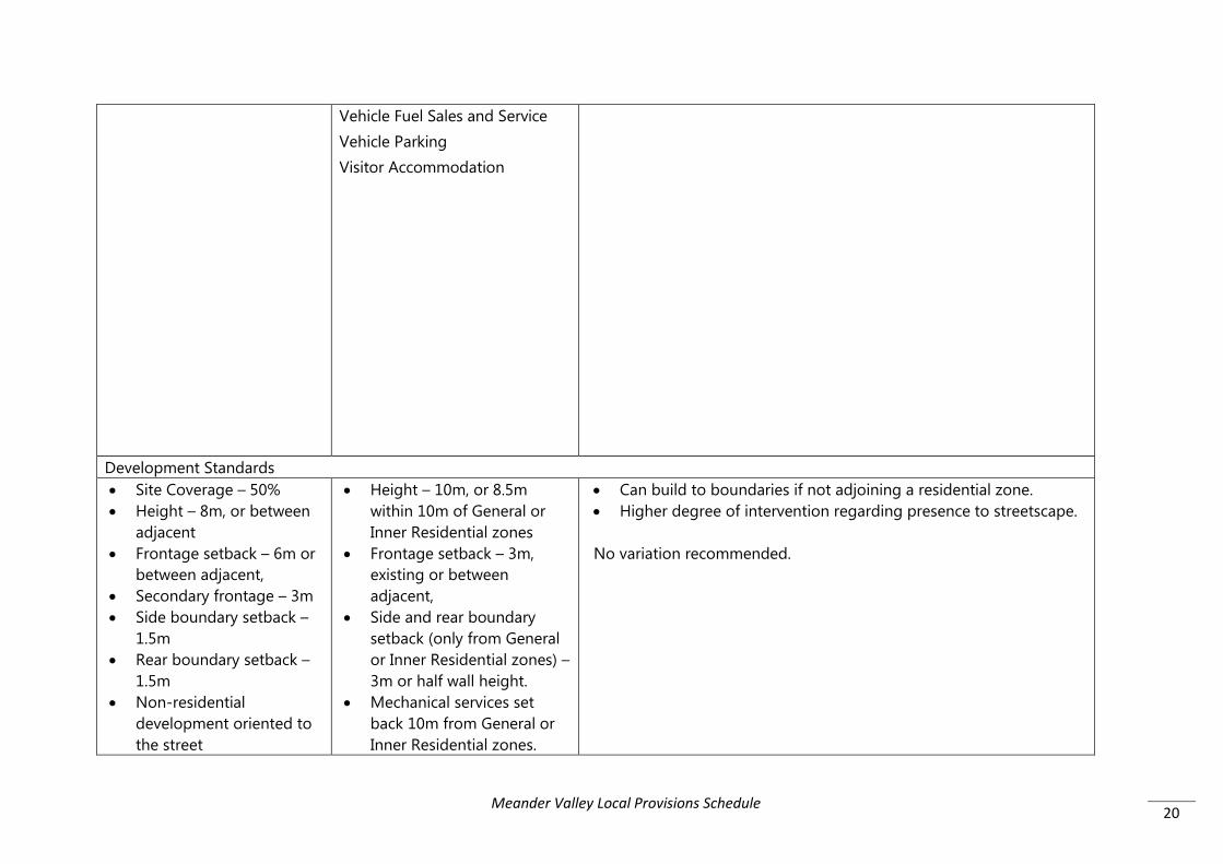
20
Vehicle Fuel Sales and Service Vehicle Parking Visitor Accommodation
Development Standards • Site Coverage – 50% • Height – 8m, or between
adjacent • Frontage setback – 6m or
between adjacent, • Secondary frontage – 3m • Side boundary setback –
1.5m • Rear boundary setback –
1.5m • Non-residential
development oriented to the street
• Height – 10m, or 8.5m within 10m of General or Inner Residential zones
• Frontage setback – 3m, existing or between adjacent,
• Side and rear boundary setback (only from General or Inner Residential zones) – 3m or half wall height.
• Mechanical services set back 10m from General or Inner Residential zones.
• Can build to boundaries if not adjoining a residential zone. • Higher degree of intervention regarding presence to streetscape. No variation recommended.
Meander Valley Local Provisions Schedule

21
• Specific multiple dwelling standards
• Design standards - streetscape impacts, visibility from the street, external lighting, pedestrian access, front façade presentation.
• Fencing within 4.5m of frontage – Discretionary
• Boundary fences with Genera/Inner Residential zones – 2.1m, no barbed wire.
• Outdoor storage – not visible from the street or public open space
• Dwellings: Private open space -24m2 and storage 6m3
Subdivision • General Suitability –
Discretionary • Min lot size – 800m2 • 15m diameter circle, 15m
from frontage & setbacks to existing buildings
• Min frontage 6m • Services – allowances for
areas without connection to full water, sewer and
• Min lot size 300m2 • 10m x 15m area, setbacks
to existing buildings • Min frontage 3.6m • Vehicle access • Services
• Higher density provisions. • Similar considerations in regard to edge effects on adjoining
residential zones.
No variation recommended.
Meander Valley Local Provisions Schedule

22
stormwater services. • Impacts on adjoining
residential zones. Local Business Zone Use No Permit Required N/A Permitted Business and professional services Food services General retail and hire (1000m2) Utilities Visitor accommodation Discretionary Business and professional services (Rutherglen) Community meeting and entertainment Educational and occasional care Emergency services General retail and hire (not department store) Manufacturing and processing Residential Service industry
No Permit Required Business and professional services Food service General retail and hire Natural and cultural values management Passive recreation Residential (home based business) Minor Utilities Permitted Bulky good sales Community meeting and entertainment Educational and occasional care Emergency services Hotel industry Pleasure boat facility Research and development Residential (above ground floor) Visitor accommodation (above ground floor or to rear)
• Greater provision for uses generally – 15 to 27 • Greater provision in the NPR and Permitted status • Impacts on residential zones if within 50m • Discretionary use tests – amenity impacts on adjoining
residential zones, intensity • PC test for discretionary uses and retail floor areas – activity
centre hierarchy impacts, Bulky goods and General retail and hire – 250m2
Meander Valley Local Provisions Schedule

23
Storage Utilities
Discretionary Equipment and machinery sales and hire Manufacturing and processing Residential Resource processing (food and beverage) Service industry Sports and recreation Storage Tourist operation Transport depot and distribution (public transport, goods within the zone Utilities Vehicle fuel sales and service Vehicle parking Visitor accommodation
Development Standards • Entrance visibility and
pedestrian access • Height – 7m, or between
adjacent • Frontage setback – 2m or
between adjacent, • Specific multiple dwelling
standards
• Height – 9m • Frontage setback - 0m, or
between adjacent, • Side and rear boundary
setback (only from General, Inner or Low Density Residential zones) – 4m or half wall height.
• Mechanical services set
• Can build to boundaries if not adjoining a residential zone. • Higher degree of intervention regarding presence to streetscape.
No variation recommended.
Meander Valley Local Provisions Schedule
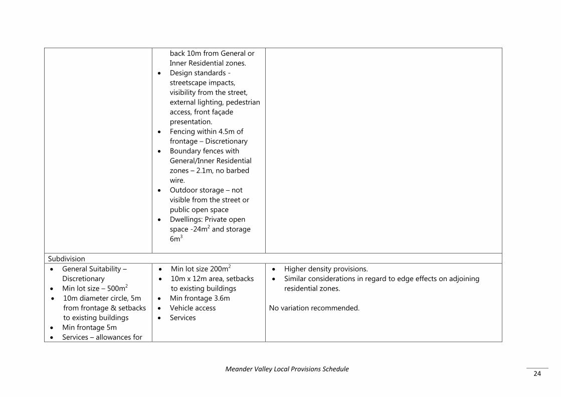
24
back 10m from General or Inner Residential zones.
• Design standards - streetscape impacts, visibility from the street, external lighting, pedestrian access, front façade presentation.
• Fencing within 4.5m of frontage – Discretionary
• Boundary fences with General/Inner Residential zones – 2.1m, no barbed wire.
• Outdoor storage – not visible from the street or public open space
• Dwellings: Private open space -24m2 and storage 6m3
Subdivision • General Suitability –
Discretionary • Min lot size – 500m2 • 10m diameter circle, 5m
from frontage & setbacks to existing buildings
• Min frontage 5m • Services – allowances for
• Min lot size 200m2 • 10m x 12m area, setbacks
to existing buildings • Min frontage 3.6m • Vehicle access • Services
• Higher density provisions. • Similar considerations in regard to edge effects on adjoining
residential zones.
No variation recommended.
Meander Valley Local Provisions Schedule

25
areas without connection to full water, sewer and stormwater services.
• Impacts on adjoining General residential or Urban Mixed Use zones.
General Business Zone No permit required: Business and professional services Food services General retail and hire (<500m2 tenancy and not a department store) Passive recreation Natural and cultural values management Permitted: Bulky goods sales General retail and hire Hotel industry Research and development Minor Utilities Vehicle fuel sales and service Discretionary: Emergency services Community meeting and entertainment
No permit required: Business and professional services Food services General retail and hire Natural and cultural values management Passive recreation Residential (home based business) Minor Utilities Permitted: Bulky good sales Community meeting and entertainment Educational and occasional care Emergency services Hotel industry Pleasure boat facility (boat ramp) Research and development Residential (above ground floor
• Uses are much the same with slight variation in status • Limits transport depot and distribution • Impacts on residential zones if within 50m • Discretionary use tests – amenity impacts on adjoining General
and Inner residential zones, intensity • PC test for discretionary uses and retail floor areas – activity
centre hierarchy impacts, Bulky goods and General retail and hire – 3500m2
No variation recommended.
Meander Valley Local Provisions Schedule

26
Recycling and waste disposal (not refuse disposal, scrap yard, vehicle wrecking) Educational and occasional care Manufacturing and processing Residential Service industry (shopfront) Sport and recreation Storage Transport depot and distribution Tourist operation Vehicle parking Visitor accommodation Utilities
or to rear) Visitor accommodation (above ground floor or to rear, not a caravan park) Discretionary: Custodial facility Equipment and machinery sales and hire Hospital services Manufacturing and processing Residential Resource processing (food and beverage) Service industry Sports and recreation Storage Tourist operation Transport depot and distribution (public transport, goods within the zone) Utilities Vehicle fuel sales and service Vehicle parking Visitor accommodation
Development Standards • Entrance visibility and
pedestrian access • Height – 8m, or 1m
• Height – 12m, 8.5m within 10m of residential zones
• Frontage setback - 0m, or
• Can build to boundaries if not adjoining a residential zone. • Higher degree of intervention regarding presence to streetscape.
Meander Valley Local Provisions Schedule

27
greater than average of adjacent
• Frontage setback – 2m or between adjacent, or not overshadowing the POS or windows of adjoining dwellings more than 50%
• 1000m2 limit to Prospect Vale Market Place building extensions.
• Specific multiple dwelling standards
between adjacent • Side and rear boundary
setback (only from General, Inner or Low Density Residential zones) – 5m or half wall height.
• Mechanical services set back 10m from General or Inner Residential zones.
• Design standards - streetscape impacts, visibility from the street, external lighting, pedestrian access, front façade presentation.
• Fencing within 4.5m of frontage – Discretionary
• Boundary fences with General/Inner Residential zones – 2.1m, no barbed wire.
• Outdoor storage – not visible from the street or public open space
• Dwellings: Private open space -24m2 and storage 6m3
Recommendation: Carry forward the floor area limitation to Prospect Vale Market Place as a SSQ, which will prevent the new car park on Jardine Crescent from potentially being taken up by a building. There are no provisions that would deal with the potential impact of this on local roads.
Subdivision • General Suitability – • Min lot size 100m2 • Higher density provisions.
Meander Valley Local Provisions Schedule

28
Discretionary • Min lot size – 200m2 • 10m diameter circle, 5m
from frontage & setbacks to existing buildings
• Min frontage 5m • Services – allowances for
areas without connection to full water, sewer and stormwater services
• Impacts on adjoining General Residential or Urban Mixed Use zones.
• setbacks to existing buildings
• Min frontage 3.6m • Vehicle access • Services
• Similar considerations in regard to edge effects on adjoining residential zones.
No variation recommended.
Light Industrial Zone Use No permit required: Natural and cultural values management Passive recreation Minor Utilities Permitted: Equipment and machinery sales and hire Storage Research and development Residential (limited extensions to existing dwellings) Utilities Vehicle fuel sales and service
No permit required: Natural and cultural values management Passive recreation Minor Utilities Permitted: Emergency services Equipment and machinery sales and hire Manufacturing and processing Port and shipping Research and development Service industry Storage
• Provides for additional uses – some higher impact such as manufacturing, relatively unchecked.
• Impacts on residential zones if within 50m for hours of operation (7am – 9pm Mon-Sat, 8am – 9pm Sun) and external lighting only. No assessment of emissions generally, other than by the Attenuation Code.
• IPS is 40m from residential uses – general assessment of emissions
• Discretionary use tests – impacts on the industrial use of surrounding land
• Prohibits new
• Extensions to NCU now discretionary
Meander Valley Local Provisions Schedule

29
Discretionary: Bulky goods Business and professional services Community meeting and entertainment Domestic animal breeding, boarding or training Emergency services Food services (café, takeaway) General retail and hire Recycling and waste disposal Resource processing (not Level 2 activity, not saleyards or abattoir) Transport depot and distribution Manufacturing and processing (not Level 2 activity) Service industry Vehicle parking
Transport depot and distribution Vehicle fuel sales and service Discretionary: Bulky goods sales (supplies extractive industry, resource development, resource processing; or landscaping, trade, hardware supplies; or timber yard ) Community meeting and entertainment Crematoria and cemeteries Domestic animal breeding, boarding or training Educational and occasional care (existing uses) Food services General retail and hire (extensions to existing) Recycling and waste disposal (waste transfer station, scrap yard) Resource processing Sports and recreation Utilities Vehicle parking
Development Standards
Meander Valley Local Provisions Schedule

30
• Height – 10m, or average of adjacent
• Frontage setback – 5.5m • Side boundary setback –
3m • Rear boundary setback –
3m
• Height – 10m, 8.5m within 10m of residential zones
• Frontage setback – 5.5m, or between adjacent
• Side and rear boundary setback (only from General, Inner or Low Density Residential and Rural Living zones) – 4m or half wall height.
• Mechanical services set back 10m from only from General, Inner or Low Density Residential and Rural Living zones.
• Boundary fences with General/Inner/Low Density Residential or Village zones – discretionary tests of amenity impact.
• Outdoor storage – not visible from the street or public open space
• Landscaping treatment to front setback
• Higher degree of intervention regarding height, mechanical services, fencing, outdoor storage and landscaping
No variation recommended.
Subdivision • General Suitability –
Discretionary • General Suitability
• Min lot size 1000m2 • setbacks to existing
buildings
• Similar considerations in regard to density • No consideration of effect on adjoining sensitive zones, appears
to rely on Attenuation Code
Meander Valley Local Provisions Schedule

31
• Min lot size – 1000m2 • 20m diameter circle • Min frontage 6m • Impacts on adjoining
General Residential, Low Density Residential, Village, Urban Mixed Use, Rural Living or Environmental Living zones.
• Services – allowances for areas without connection to full water, sewer and stormwater services
• Min frontage 20m • Vehicle access • Services – mandatory
connection to water service if available.
No variation recommended.
General Industrial Zone Use No permit required: Natural and cultural values management Passive recreation Permitted Bulky goods sales Equipment and machinery sales and hire Recycling and waste disposal Residential (limited extension to existing - SSQ) Resource processing (not sale
No permit required: Natural and cultural values management Passive recreation Minor Utilities Permitted Emergency services Equipment and machinery sales and hire Manufacturing and processing Port and shipping Recycling and waste disposal
• Similar uses. Some differences in status. • Limits bulky goods retailing more than current (eg. no car/boat
sales) and prohibits general retail and hire • Little difference between Light Industrial and General Industrial
Zones - qualifications eg. education for employment training centre in General Industrial, yet only existing in Light Industrial.
• Discretionary use tests – impacts on the industrial use of surrounding land only.
• IPS is 50m from residential uses – general assessment of emissions
No variation recommended
Meander Valley Local Provisions Schedule

32
yards, abattoir) Service industry Storage Manufacturing and processing Research and development Transport depot and distribution Minor Utilities Vehicle fuel sales and service Vehicle parking Discretionary Crematoria and cemeteries (crematoria only) Emergency services Food services (café, takeaway) Motor racing facility Resource processing Utilities
Research and development Resource processing Service industry Storage Transport depot and distribution Utilities Vehicle fuel sales and service Discretionary Bulky goods sales (supplies extractive industry, resource development, resource processing; or landscaping, trade, hardware supplies; or timber yard ) Crematoria and cemeteries (crematoria only) Educational and occasional care (employment training centre) Food services Motor racing facility Sports and recreation Vehicle parking
Development Standards • Height – 10m • Frontage setback – 5.5m • Side boundary setback –
3m
• Height – 20m • Frontage setback – 10m, or
existing, or between adjacent
• Substantive difference in height – may be obtrusive at Deloraine. • Requires greater front setback for access, parking and
landscaping. • No current requirement for landscaping
Meander Valley Local Provisions Schedule

33
• Rear boundary setback – 3m
• Side and rear boundary setback – 0m
• Landscaping treatment to front setback
Subdivision • General Suitability • Min lot size – 1500m2 • 20m diameter circle • Min frontage 6m • Impacts on adjoining
General Residential, Low Density Residential, Village, Urban Mixed Use, Rural Living or Environmental Living zones.
• Services – allowances for areas without connection to full water, sewer and stormwater services
• Min lot size 2000m2 • setbacks to existing
buildings • Min frontage 20m • Vehicle access • Services – mandatory
connection to water service if available.
• Similar considerations in regard to density • No consideration of effect on adjoining sensitive zones, appears
to rely on Attenuation Code
No variation recommended.
Rural Zone Use No permit required: Domestic animal breeding, boarding and training Natural and cultural values management Passive recreation
No permit required: Natural and cultural values management Passive recreation Resource development Minor Utilities
• Interim Scheme only utilises one Rural Resources Zone in recognition of the mix of uses and their changeability. Provides NPR/permitted pathways for primary industries.
• Now required to split the Rural Resource Zone into Rural and Agriculture Zones – (See methodology attached)
• Appears to rely on the State agriculture map that includes prime
Meander Valley Local Provisions Schedule

34
Resource development Utilities (existing + 30% increase) Permitted: Business and professional services Domestic animal breeding, boarding and training Community meeting and entertainment Crematoria and cemeteries Extractive industries Food services Hotel industry Residential Resource development Resource processing Sports and recreation Visitor accommodation Discretionary: Bulky goods sales Business and professional services Educational and occasional care Emergency services Equipment and machinery sales and hire
Permitted: Business and professional services (veterinary centre, agricultural consultant) Domestic animal breeding, boarding or training Educational and occasional care (associated with Resource Development or Resource Processing) Emergency services Extractive industry Food services (associated with Resource Development or Resource Processing) General retail and hire (associated with Resource Development or Resource Processing) Manufacturing and processing (associated with extractive industry) Pleasure boat facility(boat Ramp) Research and development (associated with Resource Development or Resource Processing) Residential (home based
land and irrigation districts within the Agriculture Zone. • State position is that this zone is for rural resources that are not
agriculture (lists forestry, extractive industry, aquaculture) • Interim Scheme provides for the permitted 30% expansion of a
number of existing uses. SPP’s provide for 30% expansion through the Acceptable Solution – still discretionary.
• Discretionary uses must demonstrate: - that location is ‘required’ (except residential) – tough test - adjoining uses are not restrained from operating - minimisation of conversion of agricultural land - location in a rural area is appropriate (except residential)
• Interim Scheme was required to assess against PAL Policy components.
• Interim Scheme required dwellings to be integral and subservient, or land not practically usable for agriculture.
• Zone purpose now requires that use ‘requires’ a rural location for operational reasons.
• Permitted uses will be virtually unchecked eg. Resource processing factories. Will undermine industrial precincts.
Meander Valley Local Provisions Schedule

35
Extractive industries Food services General retail and hire Hotel industry Motor racing facility Recycling and waste disposal Residential Research and development Resource development Resource processing Service industry Sports and recreation Tourist operation Transport depot Utilities Vehicle fuel sales and service Visitor accommodation
business, extensions) Resource processing Storage (contractors yard, cool storage, grain storage, fuel, woodyard) Utilities Visitor accommodation (existing building) Discretionary: Bulky goods sales (supplies Extractive industry, Resource development, Resource Processing; landscape supplies; timber yard; rural supplies) Business and professional services Community meeting and entertainment Crematoria and cemeteries Custodial facility Educational and occasional care Food services General retail and hire Manufacturing and processing Motor racing facility Pleasure boat facility Recycling and waste disposal Research and development Residential (single dwelling and
Meander Valley Local Provisions Schedule
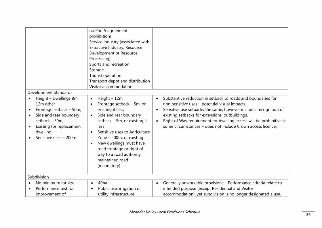
36
no Part 5 agreement prohibition) Service industry (associated with Extractive Industry, Resource Development or Resource Processing) Sports and recreation Storage Tourist operation Transport depot and distribution Visitor accommodation
Development Standards • Height – Dwellings 8m,
12m other • Frontage setback – 50m, • Side and rear boundary
setback – 50m; • Existing for replacement
dwelling • Sensitive uses – 200m
• Height – 12m • Frontage setback – 5m, or
existing if less, • Side and rear boundary
setback – 5m, or existing if less
• Sensitive uses to Agriculture Zone – 200m, or existing
• New dwellings must have road frontage or right of way to a road authority maintained road (mandatory)
• Substantive reduction in setback to roads and boundaries for non-sensitive uses – potential visual impacts
• Sensitive use setbacks the same, however includes recognition of existing setbacks for extensions, outbuildings.
• Right of Way requirement for dwelling access will be prohibitive is some circumstances – does not include Crown access licence.
Subdivision • No minimum lot size • Performance test for
improvement of
• 40ha • Public use, irrigation or
utility infrastructure
• Generally unworkable provisions – Performance criteria relate to intended purpose (except Residential and Visitor accommodation), yet subdivision is no longer designated a use.
Meander Valley Local Provisions Schedule

37
productive capacity • For approved non-
agricultural use (except residential)
• Frontage – 25m • Excision of existing
Dwelling/Visitor accommodation + Part 5 agreement prohibiting a dwelling on the balance lot.
• Frontage and access
• Will prevent repeated excision and development as dwellings will be prohibited on the balance lot.
Agriculture Use As above No permit required:
Natural and cultural values management Passive recreation Resource development (prime land restrictions – PAL Policy) Utilities Permitted: Food services (associated with Resource Development or Resource Processing) General retail and hire (associated with Resource Development or Resource Processing) Pleasure boat facility Residential (home based business, extensions) Discretionary:
• State position is that this zone is prioritised for agriculture. Less range of permitted uses, with additional tests for discretionary uses than the Rural Zone.
• Discretionary use tests: - location for operational/security reasons or to contain impacts
of emissions (except Residential, Resource Development); - minimisation of conversion of ag land (except Residential); - prime land is for extractive industry, resource development or
utilities or is of significant benefit to the region. • Residential use:
- must be required as part of an agricultural use; - be located on a site that is not capable of supporting an
agricultural use; - be located on a site that is not capable of being included with
other ag land; and - does not restrain agriculture on adjoining properties.
• Inherent contradictions in the assessment criteria for dwellings. Clarification is being sought from the TPC and Planning and Policy Unit in regard to operation.
Meander Valley Local Provisions Schedule
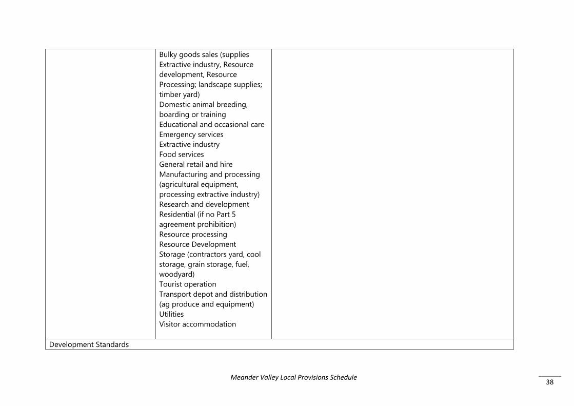
38
Bulky goods sales (supplies Extractive industry, Resource development, Resource Processing; landscape supplies; timber yard) Domestic animal breeding, boarding or training Educational and occasional care Emergency services Extractive industry Food services General retail and hire Manufacturing and processing (agricultural equipment, processing extractive industry) Research and development Residential (if no Part 5 agreement prohibition) Resource processing Resource Development Storage (contractors yard, cool storage, grain storage, fuel, woodyard) Tourist operation Transport depot and distribution (ag produce and equipment) Utilities Visitor accommodation
Development Standards
Meander Valley Local Provisions Schedule

39
As above • Height – 12m • Frontage setback – 5m, or
existing if less, • Side and rear boundary
setback – 5m, or existing if less
• Sensitive uses to Agriculture Zone – 200m, or existing
• New dwellings must have road frontage or right of way to a road authority maintained road (mandatory)
• Substantive reduction in setback to roads and boundaries for non-sensitive uses – potential visual impacts
• Sensitive use setbacks the same, however includes recognition of existing setbacks for extensions, outbuildings.
• Right of Way requirement for dwelling access will be prohibitive is some circumstances – does not include Crown access licence.
Subdivision As above • Public use, irrigation or
utility infrastructure • Provide for agricultural use • Absolute minimum of 1ha • Excision of existing use +
Part 5 agreement prohibiting a dwelling on the balance lot
• Meet setbacks to existing buildings
• Frontage and access
• General performance assessment of productive capacity for the long term protection of agricultural land.
• Will prevent repeated excision and development as dwellings will be prohibited on the balance lot.
Landscape Conservation Zone N/A No permit required
Natural and cultural values management
• Provides for a lower level of use with almost all being discretionary.
• Visitor Accommodation – Acceptable solution - existing
Meander Valley Local Provisions Schedule

40
Passive recreation Permitted Residential (home based business, single dwelling within a building area on a sealed plan) Minor Utilities Discretionary Community meeting and entertainment (art and craft centre, public hall) Domestic animal breeding, boarding and training Emergency services Food services (200m2) General retail and hire (associated with a Tourist operation) Residential (single dwelling) Resource development (not intensive animal husbandry, plantation forestry) Sports and recreation (outdoor facility) Tourist operation Utilities Visitor accommodation
buildings and 300m2. • Discretionary use tests for landscape values
Due to the inability to apply the Scenic Protection Overlay to the Low Density Residential Zone, this zone is considered appropriate for the Travellers Rest area, generally reflecting the purpose of the current Low Density Residential Zone with low key uses, together with the Scenic Protection Overlay. It is recommended however, that a local variation be included either by SSQ or SAP, to maintain the residential ‘permitted’ use right, with the discretion only being attributed to development.
Development Standards
Meander Valley Local Provisions Schedule

41
N/A • Site Coverage – 400m2 • Height – 6m • Frontage setback – 10m • Side and rear boundary
setback – 20m • Sensitive uses to Agriculture
or Rural Zone – 200m, or existing
• Exterior building finishes – light reflectance value
• New dwellings must have road frontage or right of way to a road authority maintained road (mandatory)
• Travellers Rest – Development standards are tighter than that of the Low Density Residential Zone, however remaining vacant lots have dimensions that can comply and many developed lots do comply with the setbacks. All lots have road frontage and as such will not be disadvantaged by the access standard.
• A small number of lots will not comply with the standard to be located 10m below a ridgeline, however these lots are already developed and additional development will be able to meet the performance criteria, noting that the Scenic Management overlay renders all development discretionary in this location.
Subdivision N/A • 50ha
• 25m x 25m area at 1:5 gradient
• Frontage – 40m • Vehicle access • On-site waste water
capability
• Despite the very large minimum lot size, which is much larger than the average lot size in Travellers Rest, the subdivision provisions will reflect that there is no practical capacity to create any additional lots in this locality due to on-site waste water capacity and land stability issue together with scenic values.
No variation recommended.
Environmental Management Zone Use No permit required: Natural and cultural values management
No permit required: Natural and cultural values management
• The application of the zone is effectively the same approach as the Interim Scheme in that it mainly reflects public land reserved or set aside principally for conservation purposes. It may also
Meander Valley Local Provisions Schedule

42
Passive recreation Permitted: Utilities Discretionary: Emergency services Extractive industry Residential Resource development Sports and recreation Tourist operation Utilities Visitor accommodation
Passive recreation Permitted: Community meeting and entertainment Educational and occasional care Emergency services Food services General retail and hire Pleasure boat facility Research and development Residential Resource development Sport and recreation Tourist operation Utilities Visitor accommodation Discretionary: Community meeting and entertainment Educational and occasional care Emergency services Extractive industry Food services General retail and hire Pleasure boat facility Research and development Resource development Resource processing
include private land in particular circumstances that are consistent with the zoning of public land.
• Some additional uses have been included in the SPP’s, however the use table adopts the same approach to avoid assessment duplication in that an approval through the State’s own reserve assessment processes meets the standards of the Scheme.
No variation recommended.
Meander Valley Local Provisions Schedule

43
Sport and recreation Tourist operation Utilities Vehicle parking Visitor accommodation
Development Standards • Site Coverage – 20% • Height – 6m • Frontage setback – 10m • Side and rear boundary
setback – 10m • Sensitive uses to
Agriculture or Rural Zone – 200m
• Landscape management plan
• Site Coverage – 500m2 • Height – 6m • Frontage setback – 10m • Side and rear boundary
setback – 10m, or existing • Sensitive uses to Agriculture
or Rural Zone – 200m, or existing
• Exterior building finishes – light reflectance value
• Located on cleared land
• Similar to the Interim Scheme, the standards include the State’s reserve assessment approvals process.
No variation recommended
Subdivision • General Suitability • No minimum lot size - for
public use or utilities, or approved by the State
• Min frontage 3.6m • On-site waste water
capability
• No minimum lot size – for public use or utilities, or approved by the State
• Frontage and Vehicle access
• On-site waste water capability
• Similar to the Interim Scheme, the standards include the State’s reserve assessment approvals process.
No variation recommended
Meander Valley Local Provisions Schedule

44
Major Tourism Zone Use No permit required: Minor Utilities Natural and cultural values management Passive recreation Sport and recreation (golf course) Permitted: Food services Hotel industry Sports and recreation Tourist operation (existing uses) Visitor accommodation Discretionary: Business and professional services Community meeting and entertainment General retail and hire Hotel industry Residential Tourist operation Transport depot and distribution (passenger distribution)
No permit required: Natural and cultural values management Passive recreation Minor Utilities Permitted: Community meeting and entertainment Food services (not take away) Hotel industry Sports and recreation Tourist operation Visitor accommodation Discretionary: Business and professional services Educational and occasional care Emergency services Food services General retail and hire Pleasure boat facility Research and development Residential Resource processing (food and beverages) Transport depot and distribution
• Uses are much the same with slight variation in status • Impacts on residential zones if within 50m • Discretionary use tests – amenity impacts on adjoining General,
Inner and Low Density Residential zones and Rural Living Zone, hours of operation, external lighting and commercial vehicle movements
• PC test for discretionary uses – activity centre impacts
No variation recommended.
Meander Valley Local Provisions Schedule

45
Utilities Vehicle parking
Utilities
Development Standards • Height – 6m, or 12m for
Country Club if 100m from boundary
• Frontage setback – 50m • Side and rear boundary
setback – 10m • Sensitive uses to
Agriculture or Rural Zone – 200m
• Height – 10m, 8.5m within 10m of General, Inner and Low Density Residential zones and Rural Living Zone
• Frontage setback – 10m, or existing
• Side and rear boundary setback – 5m of General, Inner and Low Density Residential zones and Rural Living Zone or half wall height
• Sensitive uses to Agriculture or Rural Zone – 200m, or existing
• Mechanical services within 10m of Inner and Low Density Residential zones and Rural Living Zone
• Standards are not significantly different in effect.
No variation recommended
Subdivision • General Suitability • No minimum lot size –
consolidation, zone boundary alignment
• Min frontage 3.6m
• No minimum lot size – for public use or utilities, consolidation
• Frontage – 3.6m • Vehicle access • Services
• Similar standards No variation recommended
Meander Valley Local Provisions Schedule

46
Utilities Zone Use No permit required: Natural and cultural values management Utilities Permitted: Natural and cultural values management Recycling and waste disposal Transport depot and distribution (bus terminal/taxi stand within road corridor, airport) Utilities Vehicle parking(park and ride facility) Discretionary: Extractive industries Passive recreation Sports and recreation
No permit required: Natural and cultural values management Passive recreation Minor Utilities Permitted: Recycling and waste disposal Transport depot and distribution Utilities Vehicle parking Discretionary: Emergency services Sports and recreation Storage Tourist operation
• Similar uses. Some variation in status. • Interim Scheme assessed discretionary uses • SPP’s - amenity impacts within 50m of General, Inner and Low
Density Residential zones and Rural Living Zone, hours of operation, external lighting and commercial vehicle movements
No variation recommended
Development Standards • Height – 6m, or 15m for
structures, heights prescribed for specific sites
• Height – 10m, 15m structures; Within 10m of General, Inner and Low Density
• Standards are not significantly different in effect. Higher degree of intervention.
No variation recommended
Meander Valley Local Provisions Schedule

47
• Frontage setback – 3m • Side and rear boundary
setback – 3m
Residential zones and Rural Living Zone – 8.5m
• Frontage setback – 5m, or existing
• Side and rear boundary setback – 5m or existing
• Mechanical services within 10m of Inner and Low Density Residential zones and Rural Living Zone
• Fencing within 4.5m of frontage
• Boundary fences • Outdoor storage
Subdivision • General Suitability • No minimum lot size –
utility purpose • Min frontage 3.6m
• No minimum lot size – for public use or utilities, consolidation
• Frontage – 3.6m • Vehicle access • Services
Community Purpose Zone Use No permit required: Passive recreation Natural and cultural values management
No permit required: Natural and cultural values management Passive recreation Minor Utilities
• Zone is now expected to be applied to all schools and major public use buildings.
• Similar range of uses • Provides for additional uses, particularly residential. • SPP’s - amenity impacts within 50m of General, Inner and Low
Density Residential zones - hours of operation, external lighting
Meander Valley Local Provisions Schedule

48
Permitted: Emergency services Community meeting and entertainment Crematoria and cemeteries Custodial facility (Ashley Centre) Educational and occasional care Hospital Services Recycling and waste disposal Residential (Hagley Farm School) Sports and recreation Minor Utilities Discretionary: Business and professional services Food services Residential Tourist operation (Visitors centre Utilities
Permitted: Business and professional services(medical, community organisation, government office, funeral parlour) Community meeting and entertainment Crematoria and cemeteries (cemetery) Educational and occasional care Emergency services Hospital services Residential (aged care, respite, retirement village, assisted housing) Tourist operation (visitors centre) Discretionary: Business and professional services Custodial facility (existing) Food services General retail and hire (market) Recycling and waste depot (existing) Sports and recreation Tourist operation Utilities Vehicle parking
and commercial vehicle movements No variation recommended
Meander Valley Local Provisions Schedule

49
Development Standards • Height – 8m • Frontage setback – 6m, or
within adjacent • Side and rear boundary
setback – 3m
• Height – 10m • Frontage setback – 5m, or
within adjacent • Side and rear boundary
setback – 3m or half wall height
• Mechanical services within 10m of Inner and Low Density Residential zones and Rural Living Zone
• Fencing within 4.5m of frontage
• Outdoor storage
• Standards are not significantly different in effect. Higher degree of intervention.
No variation recommended
Subdivision • General Suitability • No minimum lot size –
community purpose • Min frontage 3.6m
• Minimum lot size – 600m2, 10 x 15m area
• Frontage – 10m • Vehicle access • Services
• Standards are not significantly different in effect. Higher degree of intervention.
No variation recommended
Recreation Zone Use No permit required: Natural and cultural values management Passive recreation Community meeting and entertainment (Quercus Park)
No permit required: Natural and cultural values management Passive recreation Sports and recreation (not a major sports facility)
• Similar range of uses • Provides for additional uses – clarified associations • SPP’s - amenity impacts within 50m of General, Inner and Low
Density Residential zones - hours of operation, external lighting and commercial vehicle movements
• Extensions to major sporting facilities within 100m of General,
Meander Valley Local Provisions Schedule

50
Permitted: Sports and recreation Motor racing facility (extensions at Carrick speedway) Discretionary: Community meeting and entertainment Crematoria and cemeteries Emergency services General retail and hire Tourist operation Utilities Visitor accommodation
Utilities Permitted: Sports and recreation Discretionary: Community meeting and entertainment Crematoria and cemeteries (existing) Domestic animal breeding, boarding and training (training) Educational and occasional care Emergency services Food services General retail and hire (clothing, equipment associated with sports and rec) Motor racing facility Pleasure boat facility Tourist operation Utilities Vehicle parking Visitor accommodation (camping, caravan park)
Inner and Low Density Residential zones – increased spectator numbers
Variation recommended to carry forward Permitted status for Quercus Park for Community Meeting & Entertainment
Development Standards • Height – 7m • Frontage setback – 10m
• Height – 10m • Frontage setback – 5m, or
• Standards are not significantly different in effect. Higher degree of intervention.
Meander Valley Local Provisions Schedule

51
• Side and rear boundary setback – 10m
• Landscaping for discretionary uses
within adjacent • Side and rear boundary
setback adjacent to General, Inner and Low Density Residential zones – 3m or half wall height
• Mechanical services within 10m of Inner and Low Density Residential zones
• Outdoor storage
No variation recommended
Subdivision • General Suitability • No minimum lot size –
utility or public purpose • Min frontage 4m • Services
• No minimum lot size – utility or public purpose
• Frontage – 3.6m • Vehicle access • Services
• Standards are not significantly different in effect. Higher degree of intervention.
No variation recommended
Open Space Zone Use No permit required: Natural and cultural values management Passive recreation Permitted: Not used in this zone Discretionary: Community meeting and entertainment
No permit required: Natural and cultural values management Passive recreation Minor Utilities Permitted: Not used in this zone Discretionary: Community meeting and
• Provides for additional uses – includes areas of open water • SPP’s - amenity impacts within 50m of General, Inner and Low
Density Residential zones - hours of operation, external lighting.
No variation recommended
Meander Valley Local Provisions Schedule

52
Emergency services Food services General retail and hire Sports and recreation Tourist operation Utilities Vehicle parking
entertainment Crematoria and cemeteries (cemetery) Emergency services Food services General retail and hire Pleasure boat facility Resource development (marine farming shore facility, grazing) Sports and recreation Tourist operation Transport depot and distribution (water taxis, commuter ferry terminals) Utilities Vehicle parking Visitor accommodation (camping, caravan park)
Development Standards • Height – 5m • Frontage setback – 10m • Side and rear boundary
setback – 10m • Site Coverage 20% • Landscaping for
discretionary uses
• Height – 10m • Frontage setback – 5m, or
within adjacent • Side and rear boundary
setback adjacent to General, Inner and Low Density Residential zones – 3m or half wall height
• Mechanical services within 10m of Inner and Low
• Additional height could be obtrusive at a closer setback if a building.
No variation recommended
Meander Valley Local Provisions Schedule

53
Density Residential zones • Outdoor storage
Subdivision • General Suitability • No minimum lot size –
utility or public purpose • Min frontage 4m • Services
• No minimum lot size – utility or public purpose
• Frontage – 15m • Vehicle access
• Similar standards.
No variation recommended
Future Urban Zone Use No permit required: Natural and cultural values management Passive recreation Permitted: Residential (single dwelling, home based business) Discretionary: Community meeting and entertainment Utilities Visitor Accomodation
No permit required: Natural and cultural values management Passive recreation Permitted: Minor Utilities Residential (single dwelling, home based business) Resource Development (agriculture) Discretionary: Utilities
• Uses are similar however do not account for the local circumstances on Mt Leslie farm
Recommend variation to carry forward Community meeting and entertainment and Visitor Accommodation as discretionary uses.
Development Standards • Building envelope as per
PD4 • Additions to existing
dwelling • Standards are different, however will support objectives for the
protection of land for future development.
Meander Valley Local Provisions Schedule

54
• Non-residential building – Performance Criteria
• single dwelling on a lot <1000m2
• temporary in nature • Height – 8.5m • Frontage setback – 5m, or
existing • Side and rear boundary
setback – 5m, or existing • Sensitive uses to Agriculture
or Rural Zone – 200m, or existing
Recommend Particular Purpose Zone – Prospect Vale Future Urban Growth Area be zoned SPP – Future Urban without variation.
Subdivision • Prohibits additional lots • Public use, utilities, or
consolidation; or • excision of existing dwelling
As above
Meander Valley Local Provisions Schedule