longboat solar project - san bernardino county a... · longboat solar project san bernardino...
TRANSCRIPT

Visual Impact Assessment
Longboat Solar Project San Bernardino County, California
June 2015
Prepared by HDR Engineering for
Longboat Solar, LLC 505 14th Street, Suite 1150
Oakland, CA 92612

Longboat Solar, LLC | Visual Impact Assessment San Bernardino County, California
June 2015 i
TABLE OF CONTENTS
Introduction ................................................................................................................................... 1
Project Description .................................................................................................................... 1
Project Components .............................................................................................................. 1
Construction........................................................................................................................... 7
Operation and Maintenance .................................................................................................. 8
Decommissioning .................................................................................................................. 9
Project Location and Setting ................................................................................................... 10
Environmental Setting ................................................................................................................. 10
Regional Character ................................................................................................................. 10
Existing Land Use ................................................................................................................ 11
Existing Visual Character ........................................................................................................ 11
Light, Glint and Glare .............................................................................................................. 12
Regulatory Setting ...................................................................................................................... 14
Federal .................................................................................................................................... 14
State ........................................................................................................................................ 14
California Department of Transportation (Caltrans) State Scenic Highway - Eligible Scenic Highways ..................................................................................................... 14
Local ........................................................................................................................................ 14
Thresholds of Significance/Criteria ............................................................................................. 17
Methodology ............................................................................................................................... 18
Landscape Character .............................................................................................................. 18
Scenic Attractiveness .......................................................................................................... 18
Scenic Integrity .................................................................................................................... 19
Landscape Visibility ................................................................................................................. 20
Immediate Foreground: 0 to 300 feet .................................................................................. 20
Foreground: 300 feet – 0.5 mile ........................................................................................... 20
Middleground: 0.5 mile to 4 miles ........................................................................................ 20
Background: 4 miles to Horizon ........................................................................................... 21
Constituent Analysis ................................................................................................................ 21
Impact Analysis ........................................................................................................................... 21
Cumulative Impacts ................................................................................................................. 33
References .................................................................................................................................. 36

Longboat Solar, LLC | Visual Impact Assessment San Bernardino County, California
June 2015 i
Figures
Figure 1. Regional Location .................................................................................................. 2 Figure 2. Site Location Map .................................................................................................. 3 Figure 3. Site Plan ................................................................................................................ 4 Figure 4. Representative Example of Ground Mounted Tracking Photovoltaic System ....... 5 Figure 5. KOP Locations .................................................................................................... 13 Figure 6. Key Observation Point 3 – SR-58........................................................................ 23 Figure 7. Key Observation Point 5 – Pettit Road at Main Street ......................................... 25 Figure 8. Key Observation Point 1 – Terminus of Western Drive ....................................... 27 Figure 9. Key Observation Point 2 – SR-58 at Community Boulevard ............................... 30 Figure 10. Key Observation Point 4 – Community Boulevard and Lenwood Road .............. 31
Tables
Table 1. Project Site APNs ................................................................................................ 10 Table 2. County of San Bernardino Applicable Visual Laws, Regulations, or Plans ......... 15 Table 3. Cumulative Project List ........................................................................................ 34

Longboat Solar, LLC | Visual Impact Assessment San Bernardino County, California
June 2015 1
Introduction The Longboat Solar, LLC Project (Project) is a proposed solar energy facility that would generate up to 20 megawatts (MW) of alternating current electricity using single axis tracker solar photovoltaic (PV) technology within an approximately 233.47-acre portion of 324.94 acres of previously disturbed agricultural lands. HDR Engineering, Inc. was retained by Longboat Solar, LLC to perform a Visual Impact Assessment (VIA) for the Project located west of the City of Barstow, San Bernardino County, California. When fully developed, the Project would produce enough electricity to supply the energy needs for over 4,300 residences.
This VIA was prepared to identify and evaluate the potential visual and aesthetic impacts associated with the construction of this Project. The VIA follows the U.S. Forest Service (USFS) and Bureau of Land Management (BLM) methodology to assess the aesthetic conditions of the landscape, characterize the current viewing environment, and evaluate the potential impacts of a proposed project on the visual environment. Both the USFS and BLM visual assessment approaches are frameworks for visual resource management planning. While neither agency has jurisdiction over any component of the Project, these methodologies are considered appropriate for assessing visual resources impacts as they provide a standardized approach to the assessment to an environmental issue area that is largely subjective. This methodology was then applied to the assessment of the Project following significance criteria recommended in Appendix G of the California Environmental Quality Act (CEQA) Guidelines.
Project Description The Project is located on unincorporated San Bernardino County lands and situated to the immediate northwest of the City of Barstow, and north of the community of Lenwood (Figure 1, Regional Location). State Route 58 (SR-58) bounds the site to the east and north (Figure 2, Site Location Map).
Project Components
Solar Modules
The proposed solar energy generating facility will be a ground mounted tracking photovoltaic system, with a nominal capacity of up to 20 MW AC. The PV panels would be mounted on tracker technology which tilts the panels to follow the course of the sun in order to optimize the incident angle of sunlight on their surface. Figure 3 provides the project site plan for the proposed solar arrays and Figure 4 provides a representative example of a ground mounted tracking photovoltaic system. The modules are mounted on steel support posts that are driven into the native soils. The top of the arrays would be up to 12 feet above grade at the tallest point and approximately 20 inches above the grade at the lowest point. Depending on the ultimate PV design selected, the facility may consist of up to twenty separate one (1) MW ground-mounted PV system blocks.

Longboat Solar, LLC | Visual Impact Assessment San Bernardino County, California
June 2015 2
Figure 1. Regional Location

Longboat Solar, LLC | Visual Impact Assessment San Bernardino County, California
June 2015 3
Figure 2. Site Location Map

Longboat Solar, LLC | Visual Impact Assessment San Bernardino County, California
June 2015 4
Figure 3. Site Plan

Longboat Solar, LLC | Visual Impact Assessment San Bernardino County, California
June 2015 5
Figure 4. Representative Example of Ground Mounted Tracking Photovoltaic System

Longboat Solar, LLC | Visual Impact Assessment San Bernardino County, California
June 2015 6
Inverters
The wiring from each solar module delivers direct current (DC) power along a proposed underground trench or aboveground conduit to the inverters located on electrical equipment pads. The inverters convert the DC power to alternating current (AC) where the power is stepped up in voltage. Concrete supports will be used for the footings, foundations, and pads for the inverters. Underground cables would be installed in conjunction with internal access roads and panel arrays in order to connect each inverter to a feeder circuit, with the exception that the Project may use overhead collector and communication lines where it crosses two natural gas pipelines on the southern portion of APN 0497-101-14. The different solar panel circuits would gather at the switchyard and would then be sent by overhead electrical lines to a grid interconnection point. Specific placement of inverters would be determined by constraints including, but not limited to, environmental, cultural, topographic, site-specific engineering, County requirements and BMPs for construction.
Control and Storage Containers
The Project will have a prefab modular air conditioned container for control system and sensitive electronics measuring approx. 10’ wide x 40’ long x 9’ high, and a metal storage container measuring approx. 10’ wide x 40’ long x 9’ high for spare parts and maintenance materials. Both containers will be unmanned and non-habitable. These features would be located in the proposed laydown and parking area proposed near the central portion of the project site; immediately south of Community Boulevard.
Control System
The site would have a Supervisory Control and Data Acquisition (SCADA) system that would allow for remote monitoring and control of inverters and other Project components. The SCADA system would be able to monitor Project output and availability as well as run diagnostics on the equipment.
Onsite Meteorological Station
The site would contain two or more on-site solar meteorological stations (SMS), which would consist of solar energy (irradiance) meters as well as air temperature and wind meters. Power for each SMS would be provided by the plant auxiliary power system or a dedicated PV module with a small battery.
Interconnection and Switchgear
Collector lines from each inverter would gather at the Project’s switchgear, from which electricity would then be sent by overhead line to the electrical grid via a line tap on the existing 33kV transmission line located adjacent to the Project site along Community Boulevard. To safely facilitate the transition from the underground collection system and the Project switchgear , SCE will place up to three additional 40-foot wooden poles south of the existing pole on Community Boulevard through APN 0497-101-05 to accommodate various switching and control mechanisms. At this point the power generated from the Project changes ownership from the Project developer to SCE. SCE will undertake distribution line upgrades, repairs and modifications along the 33kV lines to SCE’s Barstow Substation located in the City of Barstow approximately 4.5 miles east of the Project site. SCE upgrade work will consist of up to eleven
Longboat Solar, LLC | Visual Impact Assessment San Bernardino County, California
June 2015 7
pole replacements, re-conductoring of up to 2900 feet of electrical line and several minor substation upgrades.
Access
Access to the Project site would be directly from Community Boulevard by two main driveways, one for the portion of the Project south of Community Boulevard and one for the portion of the Project site north of Community Boulevard. In addition, a secondary access driveway and a temporary access driveway into the temporary storage and laydown area are also located on the south side of Community Boulevard along the parcel frontages. These additional access points would also be used for emergency access. Typical site access will consist of a 30-foot wide driveway to accommodate a wide turning radii in both directions. The proposed site access will include a 60-foot-long drive apron off of Community Boulevard. Internal roads for access around the perimeter and within the solar field will be built of compacted native soil roads per the geotechnical report recommendations. Both the perimeter access road and the internal access roads would be constructed in conformance with County Fire Department standards required for fire prevention. In accordance with County standards, a 26 foot-wide perimeter road and 20-foot-wide internal roads have been incorporated into the site design. These access roads would remain in place for ongoing operations and maintenance activities after construction is completed. Final service road alignments would depend on the final placement of the solar panels and on the results of the environmental report documenting the results of field investigations, including topography and any other site-specific details to be incorporated into the final design.
Lighting, Fencing and Signage
The proposed Project will provide external safety lighting for both normal and emergency conditions at the primary access points. Lighting will be designed to provide the minimum illumination needed to achieve safety and security and will be downward facing and shielded to focus illumination in the immediate area. The Project perimeter will be secured with 8 foot-tall security fencing. All Project fencing will be set back 15 feet from the property line or public right-of-way. Additional fencing requirements by local ordinance, rule or Project-specific Condition of Approval will be incorporated as applicable.
All Project signage requirements would be evaluated, and the best-fit scenario would be incorporated into the Project based on the final Project design.
Construction
Phasing
Construction of the project is expected to begin in the fourth quarter of 2015 and last up to 10 months, with a peak workforce of 181 construction workers on the site. Construction would be comparable to other renewable energy projects and is anticipated to be divided into the following sequence, although each of these sequences may overlap with one another: (1) roads, grading, and fencing (2) electrical infrastructure, (3) PV assembly and installation, (4) substation interconnection, (5) electrical system upgrades, (6) PV commissioning, and (7) project finalization. Table 2 provides a summary of the Project’s construction phases, anticipated construction equipment and maximum vehicle daily trips. Various elements of the Project would

Longboat Solar, LLC | Visual Impact Assessment San Bernardino County, California
June 2015 8
be constructed concurrently on the property. The total duration of construction is not expected to exceed 10 months. The Project construction sequence is expected to begin with removal of vegetation for installation of the PV module structures. Any large vegetation and brush that currently exists on the site will be removed and the surface graded flat where necessary for safe construction practices. Existing low-lying vegetation will remain undisturbed where possible to provide ground cover and minimize dust generation. A stabilized entrance/exit will be provided to clean vehicle wheels prior to exiting the construction area.
Site Grading
Minimal site grading is proposed for the majority of the site with finished topographical grades being similar to existing conditions. Minor cuts may be required at the locations of inverters and other equipment to provide level foundations. Grubbing would occur on all access roads, and in any areas where the roots would impede a project structure. The installation of the solar panels also requires trenching for the installation of multiple cable systems. Within the Project site there are two earthen irrigation impoundments that will be demolished and the soil from these impoundments will be rebroadcast through the Project site. Initial grading work will include the use of excavators, graders, dump trucks, and end loaders, in addition to support pickups, water trucks, and cranes.
Construction Access and Staging Areas
It is anticipated that construction workers would utilize Community Boulevard as points of ingress/egress to the Project site and, once on the Project site, these workers would access various sections via the existing and improved network of gravel roads. As shown in Figure 2, Community Boulevard would be used to facilitate construction access to and from the north, south, east, and west portions of the Project site.
Staging areas may be required for material handling, temporary storage, and staging activities. Figure 2 depicts the proposed limits of construction, which includes construction work areas that extend beyond the Project site (i.e., staging areas, access, interconnections). One staging yard, proposed on the south side of Community Boulevard (APN 0497-101-09), is under a short-term lease with the applicant and would be used for parking and construction staging. Upon the completion of construction, this temporary staging yard would no longer be a part of the Project. All other construction staging will occur on the Project site. Temporary containers with equipment will be placed in the staging and lay-down areas. There may be a temporary modular construction office onsite during construction. Disturbed areas, temporary roadways, and equipment laydown sites not required as part of the ongoing operation of the facility would be restored. Temporary access roads would be restored following completion of construction. Permanent disturbance is related to operational facilities, and would include the permanent roadways, parking areas, access roads, and equipment that would remain in place for the life of the Project.
Operation and Maintenance
The project would be operated on an autonomous, unstaffed basis and monitored remotely from an existing off-site facility. It is anticipated that maintenance requirements will be minimal as the proposed project's PV arrays will operate with limited moving parts. No full-time staffing would

Longboat Solar, LLC | Visual Impact Assessment San Bernardino County, California
June 2015 9
be required to operate the facility; however one or two employees are expected to visit the site five days per week for routine maintenance and check-ups. Operational activities are limited to monitoring the solar plant performance and responding to utility needs for solar plant adjustment along with preventative and unscheduled maintenance. The project will operate during daylight hours only. Periodic module cleanings and quarterly maintenance activities might utilize six to eight full-time workers for one to two weeks per quarter, or up to 40 days per year. No heavy equipment will be used during normal project operation. Operation and maintenance vehicles will include trucks (pickup, flatbed), forklifts, and loaders for routine and unscheduled maintenance, and water trucks for solar module washing. Large heavy-haul transport equipment may be brought to the site infrequently for equipment repair or replacement. Any required maintenance will be scheduled so as to avoid peak electric load periods, with unplanned maintenance activity as needed depending on the event. Preventative maintenance kits and certain critical spare components will be stored at the Project site, while all other necessary maintenance components will be available at an offsite location. On an as-needed basis, SCE will make necessary inspections, maintenance and improvements to their facilities that are on-site connecting the project to the distribution grid.
Vegetation is sparse with little potential for vegetative fuel buildup. The applicant will prepare a fire prevention plan for the Project in compliance with applicable County regulations. The Project would produce a small amount of waste associated with maintenance activities. PV solar farm wastes typically include broken and rusted metal, defective or malfunctioning modules, electrical materials, empty containers, and other miscellaneous solid materials including typical household type refuse generated by workers. These materials will be collected and recycled to the extent possible.
Decommissioning
At the end of the Project site’s operational term, the applicant may determine that the site should be decommissioned and deconstructed, or it may seek an extension of its CUP. When the arrays are removed after the Project’s lifetime, the land will be largely unaltered from its natural state. The Project would utilize BMPs to ensure the collection and recycling of modules to the extent feasible.
The decommissioning plan would include a collection and recycling program to promote recycling of Project components and minimize disposal of Project components in landfills. All decommissioning and restoration activities would adhere to the requirements of the appropriate governing authorities and in accordance with all applicable federal, State, and County regulations.

Longboat Solar, LLC | Visual Impact Assessment San Bernardino County, California
June 2015 10
Project Location and Setting The Project is located in unincorporated San Bernardino County, approximately 1.6 miles north of the community of Lenwood and immediately northwest of the City of Barstow (Figure 1). The Project site includes portions of County Assessor’s Parcel Numbers (APNs) 0497-071-40, 0497-121-28, 0497-101-05, and 0497-101-14 (Table 1 and Figure 2).
The Project site is located within the U.S. Geological Survey (USGS) 7.5-minute Barstow quadrangle (Township 10 North, Range 2 West, Section 33 and Township 9 North, Range 2 West, Sections 4 and 5). The site is generally level with the elevation only increasing slightly from 2,167 feet above mean sea level (msl) in the eastern portion of the site to 2,185 feet msl in the western portion. The Project site is bound to the north and east by SR-58 and undeveloped land and the Mojave River to the south. Community Boulevard bisects the central portion of the Project site (east-west). Figure 2 depicts the proposed limits of construction, which includes construction work areas that extend beyond the Project site (i.e., staging areas, access, interconnections).
Table 1. Project Site APNs
Assessor’s Parcel Number
Gross Acreage Owner
Address (Barstow, CA 92311)
0497-071-40 40.34 Hill’s Ranch, Inc. 25749 Community Blvd.
0497-101-05 77.51 Hill’s Ranch, Inc. 25749 Community Blvd.
0497-101-14 99.77 Soppeland Revocable Trust 25409 Community Blvd.
0497-121-28 107.32 Hill’s Ranch, Inc. 25749 Community Blvd.
Environmental Setting Regional Character The Project site is located within the Mojave Desert, northwest of Barstow, California. The Mojave Desert is a subsection of the Basin and Range Physiographic Province, which is characterized by long, north-south-trending mountain ranges separated by broad valleys. Mount General, located approximately 2.7 miles north of the Project site, and the Waterman Hills, located approximately 5.5 miles northeast of the Project site, rise to elevations of 3,000 feet and are the most distinctive topographical features within the surrounding area. These ranges contain one active, and three inactive stone and sand quarries which are visible from the Project site. The Best Rock Quarry remains active and is visible to the northwest of the Project site. The closed Lynx Cat Mountain Quarry and Hill Top Quarry are visible to the northeast. These quarries have resulted in permanent scars on the background landscape and diminish the existing visual character of the area. Iron Mountain East is located approximately 7.2 miles southwest of the Project site and is visible on clear days.
The Project site is located at the southern end of the Hinkley Valley, just north of the Mojave River. The immediate surrounding area is agricultural in character with a mix of scattered, residential and industrial structures intermixed with agricultural fields. Surrounding views from
Longboat Solar, LLC | Visual Impact Assessment San Bernardino County, California
June 2015 11
the Project site consist of the SR-58 to the north and east, the BNSF railroad tracks, disturbed desert, landscapes and agricultural land uses (livestock feed production) to the west and south. More urban, rural-residential land uses and related structures, including utility poles, associated with the City of Barstow and community of Lenwood are located further to the east and south of the Project site.
Existing Land Use
The Project site is located in unincorporated San Bernardino County just west of the City of Barstow and north of the City of Lenwood. The Project site is currently vacant with three existing agricultural residences located immediately adjacent on APNs 0497-121-28 and 0497-101-14. The Project site is zoned Agriculture (AG) and Rural Living 5-acre Minimum (RL-5). Vegetation across the Project site is generally disturbed and consists of fallow agriculture fields with disturbed saltbush scrub, partially stabilized dunes, tamarisk/ornamental windrows, and abandoned agriculture. A railway is located north and east of SR-58
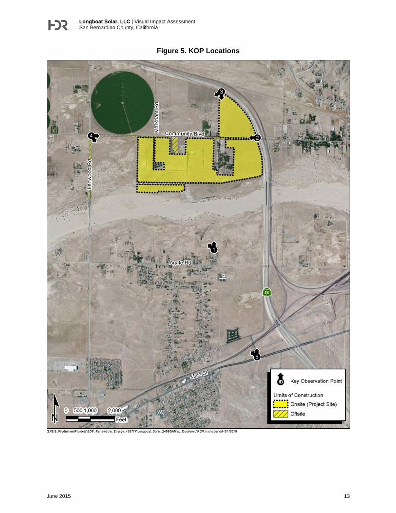
Existing Visual Character To characterize existing conditions on the Project site “key observation points” (KOPs) were identified and presented to the County for approval. BLM defines KOPs as “one or a series of points on a travel route or at a use area or a potential use area, where the view of a management activity would be most revealing.” Five KOPs were selected to determine the potential visual impacts of the Project solar facilities as described in the Project Description on the existing environment. The location of the five KOPs and the direction of the photographs taken are presented in Figure 5. Below is a brief description of each KOP. Specific terminology used is described further in detail in the Methodology Section. Additional detail, including supporting photo-documentation of existing conditions for each of the KOP locations, is provided in the Impact Analysis.
Key Observation Point 1 – Terminus of Western Drive. As shown in Figure 5, KOP 1 is located at the terminus of Western Drive, north of Agate Road. This KOP represents a residential view perspective, with a view to the north and the Project site contained in the middleground1. This view consists of native and non-native disturbed habitat with the Mojave River located between this KOP location and the Project site. Ridgelines associated with the Waterman Hills are visible in the background.
Key Observation Point 2 – SR-58 at Community Road. As shown in Figure 5, KOP 2 is located adjacent to the eastern boundary of the Project site on Community Boulevard at the SR-58 underpass. This KOP depicts views from the roadway and a resident perspective; oriented to the west. This KOP is positioned on the SR-58 bridge embankment at approximately 1012 feet above the prevailing ground surface to the west and shows the Project site on -both sides of Community Road in the foreground. As shown, multiple visual encroachments exist including power poles and fencing.
1 For this analysis, the following four viewing distances were used, as described and defined by the U.S. Department of Agriculture Forest Service (USDA Forest Service 1995): (1) Immediate Foreground (from the viewer to 300 feet away); (2) Foreground (300 feet to 0.5 mile away); (3) Middleground (between 0.5 and 4 miles away); and Background (4 miles to the horizon).

Longboat Solar, LLC | Visual Impact Assessment San Bernardino County, California
June 2015 12
Scattered agricultural structures and several rows of trees serving as windbreaks are visible in the middle and background.
Key Observation Point 3 – SR-58. As shown in Figure 5, KOP 3 is located adjacent to the northern corner of the Project site and along the southbound shoulder of SR-58. This KOP depicts views from the highway, oriented to the south/southwest. This view contains the Project site in the fore- and middleground, which consists of vacant land, previously used for agriculture, with some trees shielding a residence in the foreground. Distant views of the Project site from the west along SR-58 and the railway to the north are obstructed by an existing berm (8 to 10 feet in height) that parallels the highway to south and ends approximately 0.3 mile west of the Project site. Multiple ridgelines, including Iron Mountain West, are visible in the background to the south.
Key Observation Point 4 – Lenwood Road and Community Boulevard. As shown in Figure 5, KOP 4 is located at the southeast corner of Lenwood Road and Community Boulevard and oriented in a southeast direction. This KOP depicts the Project site in the middleground with views consisting of vacant land and areas previously used for agricultural uses. No residences are located between this KOP and the Project site; however, west of Lenwood Road are several residences that would share views similar to those shown for this KOP. Several shallow ridgelines, just south of Barstow, are visible in the background.
Key Observation Point 5 – Pettit Road at Main Street. As shown in Figure 5, KOP 5 is located at the corner of Pettit Road at Main Street (National Trail Highway/Route 66) in a slight northwest direction. This KOP depicts the Project site in the background and areas within the community of Lenwood in the fore- and middleground. An active railway that parallels Main Street and crosses over Pettit Road via an existing bridge overcrossing and is contained in the middleground.
Light, Glint and Glare Existing sources of light in the Project area are limited to outdoor lighting sources in the area, such as street lights, including that from SR-58, and structural lighting at scattered residential locations. Mobile sources of light and glare originate from vehicles and metal buildings. The rural residential structures located near the Project site and the adjacent industrial operation combined with automobile traffic on SR-58 are the primary sources of nighttime lighting.
Glare is considered a continuous source of brightness, relative to diffused light, whereas glint is a direct redirection of the sun beam in the surface of a PV solar module. Glint is highly directional, since its origin is purely reflective, whereas glare is the reflection of diffuse irradiance; it is not a direct reflection of the sun. Sources of glare in the Project area include windows and reflective building materials such as metal roofs.
Longboat Solar, LLC | Visual Impact Assessment San Bernardino County, California
June 2015 13
Figure 5. KOP Locations

Longboat Solar, LLC | Visual Impact Assessment San Bernardino County, California
June 2015 14
Regulatory Setting The following section outlines all Federal, state, and local laws, policies, and regulations which apply to the study area and were considered in the development of this visual resources analysis.
Federal There are no applicable Federal plans or policies that would apply to visual resources within the Project site.
State California Department of Transportation (Caltrans) State Scenic Highway - Eligible Scenic Highways
California's Scenic Highway Program was created by the Legislature in 1963. Its purpose is to preserve and protect scenic highway corridors from change that would diminish the aesthetic value of lands adjacent to highways. The state laws governing the Scenic Highway Program are found in the Streets and Highways Code, Section 260 et seq. The State Scenic Highway System includes a list of highways that are either eligible for designation as scenic highways or have been so designated. The status of a state scenic highway changes from eligible to officially designated when the local jurisdiction adopts a scenic corridor protection program, applies to Caltrans for scenic highway approval, and receives notification from Caltrans that the highway has been designated as a State Scenic Highway.
SR-58 located north and east of the Project site is identified as an “Eligible State Scenic Highway – not officially designated.” In addition, Main Street, (also referred to as National Trails Highway or Route 66) is located approximately 1.5-mile south of the Project site, and is a section of roadway known as the historic “Route 66.” This roadway was originally a federal route, established on November 11, 1926. It transverses 2,347 miles from Chicago through Missouri, Kansas, Oklahoma, Texas, New Mexico, and Arizona before ending at the beach in Santa Monica, California. Route 66, a major migratory road west, especially during the Great Depression, currently exists as Historic Route 66, a National Scenic Byway, and is commemorated, by various organizations along the way, including the California Historic Route 66 Association (Caltrans).
Local The Project site is under the County of San Bernardino jurisdiction and subject to the County Development Code and General Plan guidelines. The County General Plan does not specifically contain a visual element; however, it addresses this resource in Section V – Conservation Element.

Longboat Solar, LLC | Visual Impact Assessment San Bernardino County, California
June 2015 15
Table 2. County of San Bernardino Applicable Visual Laws, Regulations, or Plans
Law, Regulation, or Plan Summary
County of San Bernardino Development Code 82.19.040 Development Criteria within Scenic Areas
(c) Building and structure placement. Structure placement and style shall be compatible with and shall not detract from the visual setting or obstruct significant views.
(d) Review area. Land development proposals, including but not limited to residential facilities, commercial activities and mobile home parks/manufactured home land-lease community, shall be designed to blend into the natural landscape and maximize visual attributes of the natural vegetation and terrain. The design of development proposals shall also provide for maintenance of a natural open space parallel to and visible from the right-of-way.
(h) Above ground utilities. Utilities shall be constructed and routed underground except in those situations where natural features prevent the underground siting or where safety considerations necessitate above ground construction and routing. Above ground utilities shall be constructed and routed to minimize detrimental effects on the visual setting of the designated area. Where it is practical, above ground utilities shall be screened from view from either the Scenic Highway or the adjacent scenic or recreational resource by existing topography, or by placement of structures.
(i) Grading. The alteration of the natural topography of the site shall be minimized and shall avoid detrimental effects to the visual setting of the designated area and the existing natural drainage system. Alterations of the natural topography shall be screened from view from either the Scenic Highway or the adjacent scenic or recreational resource by landscaping and plantings which harmonize with the natural landscape of the designated area, and which are capable of surviving with a minimum of maintenance and supplemental water.
84.29.035 Required Findings for Approval of a Commercial Solar Energy Facility
(c)(2) Proposed fencing, walls, landscaping, and other perimeter features of the proposed commercial solar energy generation facility will minimize the visual impact of the project so as to blend with and be subordinate to the environment and character of the area where the facility is to be located.
(3) The siting and design of the proposed commercial solar energy generation facility will be either:
(A) unobtrusive and not detract from the natural features, open space and visual qualities of the area as viewed from communities, rural residential uses, and major roadways and highways, or
(B) located in such proximity to already disturbed lands, such as electrical substations, surface mining operations, landfills, wastewater treatment facilities, etc., that it will not further detract from the natural features, open space and visual qualities of the area as viewed from communities, rural residential uses, and major roadways and highways.
(4) The siting and design of project site access and maintenance roads have been incorporated in the visual analysis for the project and shall minimize visibility from public view points while providing needed access to the development site.
(25) For proposed commercial solar energy generation facilities within two (2) miles of the Joshua Tree National Park boundaries, the location, design, and operation of the proposed commercial solar energy generation facility will not be a predominant visual feature along the main access roads to the park (Park

Longboat Solar, LLC | Visual Impact Assessment San Bernardino County, California
June 2015 16
Law, Regulation, or Plan Summary
Boulevard and Utah Trail), nor will it substantially impair views from hiking/nature trails, campgrounds, and backcountry camping areas within the National Park.
(26) For proposed facilities within two (2) miles of the Mojave National Preserve boundaries, the location, design, and operation of the proposed commercial solar energy facility will not be a predominant visual feature of, nor substantially impair views from, hiking and backcountry camping areas within the National Preserve.
(27) For proposed facilities within two (2) miles of Death Valley National Park boundaries, the location, design, and operation of the proposed commercial solar energy facility will not be a predominant visual feature of, nor substantially impair views from, hiking and backcountry camping areas within the National Park.
(28) For proposed facilities within two (2) miles of the boundaries of a County, state or federal agency designated wilderness area, the location, design, and operation of the proposed commercial solar energy facility will not be a predominant visual feature of, nor substantially impair views from, the designated wilderness area.
Chapter 83.07 Glare and Outdoor Lightning
Standards for outdoor lighting in the Mountain and Desert Regions, unless exempt in compliance with Subsection 83.070.040(e). This section provides guidance on the maximum height, shielding requirements, determination of light trespass, and direction for non-conforming light fixtures.
County of San Bernardino General Plan Section VI – Open Space Element Goal CO 1.2 The preservation of some natural resources requires the establishment of a
buffer area between the resource and developed areas. The County will continue the review of the Land Use Designations for unincorporated areas within one mile of any state or federally designated scenic area, national forest, national monument, or similar area, to ensure that sufficiently low development densities and building controls are applied to protect the visual and natural qualities of these areas.
Goal OS 4 The County will preserve and protect cultural resources throughout the County, including parks, areas of regional significance, and scenic, cultural and historic sites that contribute to a distinctive visual experience for visitors and quality of life for County residents.
Goal OS 5 The County will maintain and enhance the visual character of scenic routes in the County.
Policy OS 5.1 Features meeting the following criteria will be considered for designation as scenic resources:
a. A roadway, vista point, or area that provides a vista of undisturbed natural areas.
b. Includes a unique or unusual feature that comprises an important or dominant portion of the viewshed (the area within the field of view of the observer).
c. Offers a distant vista that provides relief from less attractive views of nearby features (such as views of mountain backdrops from urban areas).
Policy OS 5.2 Define the scenic corridor on either side of the designated route, measured from the outside edge of the right-of-way, trail, or path. Development along scenic corridors will be required to demonstrate through visual analysis that proposed improvements are compatible with the scenic qualities present.
Longboat Solar, LLC | Visual Impact Assessment San Bernardino County, California
June 2015 17
Law, Regulation, or Plan Summary
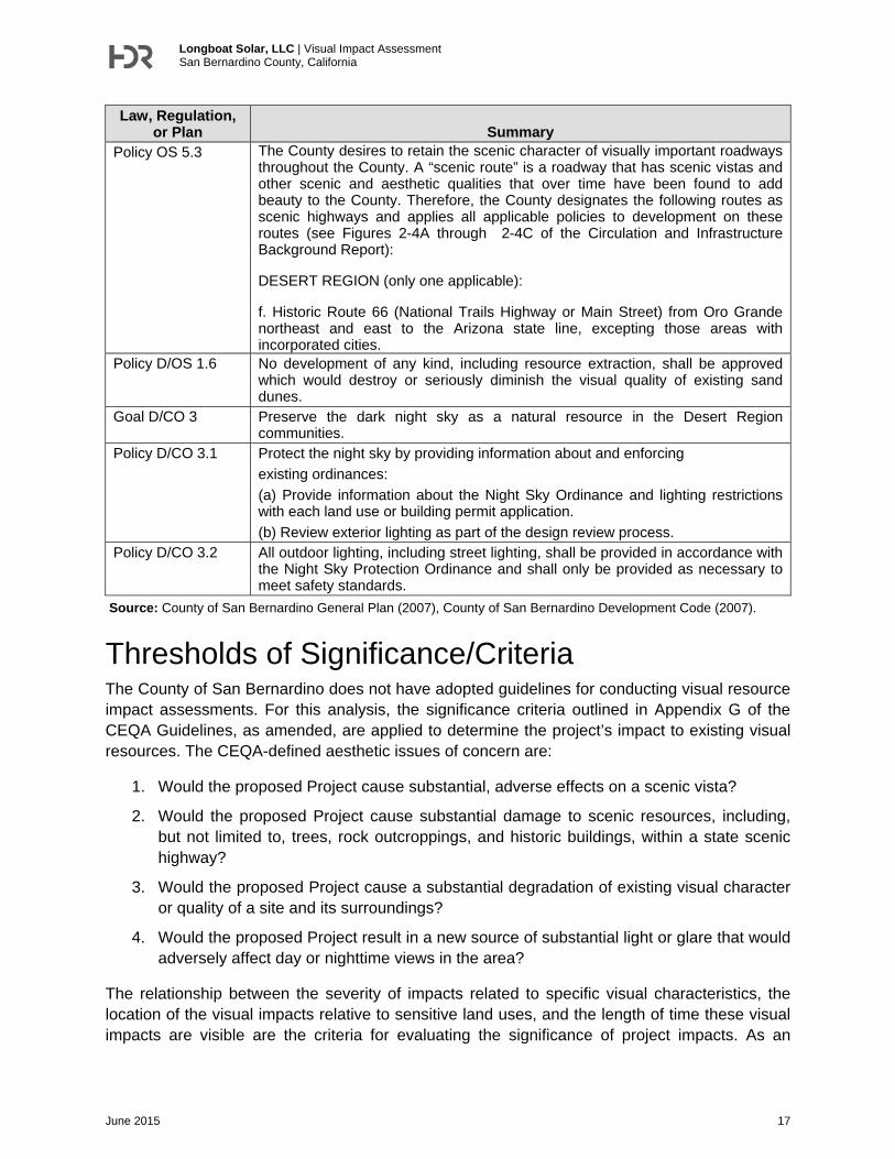
Policy OS 5.3 The County desires to retain the scenic character of visually important roadways throughout the County. A “scenic route” is a roadway that has scenic vistas and other scenic and aesthetic qualities that over time have been found to add beauty to the County. Therefore, the County designates the following routes as scenic highways and applies all applicable policies to development on these routes (see Figures 2-4A through 2-4C of the Circulation and Infrastructure Background Report):
DESERT REGION (only one applicable):
f. Historic Route 66 (National Trails Highway or Main Street) from Oro Grande northeast and east to the Arizona state line, excepting those areas with incorporated cities.
Policy D/OS 1.6 No development of any kind, including resource extraction, shall be approved which would destroy or seriously diminish the visual quality of existing sand dunes.
Goal D/CO 3 Preserve the dark night sky as a natural resource in the Desert Region communities.
Policy D/CO 3.1 Protect the night sky by providing information about and enforcing
existing ordinances:
(a) Provide information about the Night Sky Ordinance and lighting restrictions with each land use or building permit application.
(b) Review exterior lighting as part of the design review process. Policy D/CO 3.2 All outdoor lighting, including street lighting, shall be provided in accordance with
the Night Sky Protection Ordinance and shall only be provided as necessary to meet safety standards.
Source: County of San Bernardino General Plan (2007), County of San Bernardino Development Code (2007).
Thresholds of Significance/Criteria The County of San Bernardino does not have adopted guidelines for conducting visual resource impact assessments. For this analysis, the significance criteria outlined in Appendix G of the CEQA Guidelines, as amended, are applied to determine the project’s impact to existing visual resources. The CEQA-defined aesthetic issues of concern are:
1. Would the proposed Project cause substantial, adverse effects on a scenic vista?
2. Would the proposed Project cause substantial damage to scenic resources, including, but not limited to, trees, rock outcroppings, and historic buildings, within a state scenic highway?
3. Would the proposed Project cause a substantial degradation of existing visual character or quality of a site and its surroundings?
4. Would the proposed Project result in a new source of substantial light or glare that would adversely affect day or nighttime views in the area?
The relationship between the severity of impacts related to specific visual characteristics, the location of the visual impacts relative to sensitive land uses, and the length of time these visual impacts are visible are the criteria for evaluating the significance of project impacts. As an
Longboat Solar, LLC | Visual Impact Assessment San Bernardino County, California
June 2015 18
example, the permanent removal and conversion of an undisturbed, natural area to an urban land use (i.e., commercial) or the modification of an existing historically-significant structure with the foreground view of a state-designated state highway could have a significant visual impact under CEQA. In contrast, the conversion of previously disturbed areas, including agricultural lands to urban land use, may not be significant under CEQA; especially if adjacent areas already included these types of landscape alterations.
Methodology The County of San Bernardino Land Use Services Department has determined that the U.S. Forest Service (USFS) Scenery Management System (USFS 1995) should be applied for evaluation of proposed projects’ potential scenic or visual impacts even if a project site is not located within the National Forest. Based on this direction, the impact analysis uses terminology and follows impact assessment guidance as recommended by USFS. The selection of each KOP included consideration for representative vantages of the most visually sensitive areas that have the potential to view the Project. Additionally, the location and vantage for KOPs were approved by the County of San Bernardino on January 16, 2015.
Following USFS’s methodology, changes in visual character for each KOP are assessed through an evaluation of the pre-Project conditions as photo-documented and the post-Project conditions using visual simulations of the Project facilities. This methodology required photo-documentation of existing conditions in the field by HDR on March 12 and 18, 2015 and recordation of the site coordinates using global positioning systems (GPS). Using the acquired photographs, HDR created a 3-D physical massing model that incorporates the PV scale model, placed in array configurations as exhibited in the site plan provided in Figure 3. The model is then incorporated into GPS controlled site-specific photography to create simulations that demonstrate visual impact (or lack thereof). For the analysis, HDR created visual simulations representing the proposed single axis tracker solar PV technology as depicted in Figure 4. The topography obtained from the site plan was un-changed with the expectation of the removal of two agriculture containment structures, which would be removed as part of the Project.
Current industry standard procedures were used for the development of the visual simulations, resulting in the visual simulation that is both seamless and accurate based on the site plan details. The photo simulations presented are by no means representative of all views affected. They are included to provide the reader with a better overall sense of project changes to the existing environment as well as to help visualize public perception and responses to these changes. Specific terminology used in describing these changes is provided below.
Landscape Character Landscape character is based on the scenic attractiveness of an area (scenic class and scenic integrity), as described below:
Scenic Attractiveness
Class A—Distinctive
Areas where landform, vegetation patterns, water characteristics, and cultural features combine to provide unusual, unique, or outstanding scenic quality. These landscapes have strong

Longboat Solar, LLC | Visual Impact Assessment San Bernardino County, California
June 2015 19
positive attributes of variety, unity, vividness, mystery, intactness, order, harmony, uniqueness, pattern, and balance.
Class B—Typical
Areas where landform, vegetation patterns, water characteristics, and cultural features use combine to provide ordinary or common scenic quality. These landscapes have generally positive, yet common, attributes of variety, unity, vividness, mystery, intactness, order, harmony, uniqueness, pattern, and balance. Normally they would form the basic matrix within the ecological unit.
Class C—Indistinctive
Areas where landform, vegetation patterns, water characteristics, and cultural land use have low scenic quality. Often water and rockform of any consequence are missing in class C landscapes. These landscapes have weak or missing attributes of variety, unity, vividness, mystery, intactness, order, harmony, uniqueness, pattern, and balance.
Scenic Integrity
The scenic integrity levels are described below:
Very High (Unaltered) - Preservation
Very High scenic integrity refers to landscapes where the valued landscape character "is' intact with only minute if any deviations. The existing landscape character and sense of place is expressed at the highest possible level.
High (Appears Unaltered) - Retention
High scenic integrity refers to landscapes where the valued landscape character "appears" intact. Deviations may be present but must repeat the form, line, color, texture, and pattern common to the landscape character so completely and at such scale that they are not evident.
Moderate (Slightly Altered) - Partial Retention
Moderate scenic integrity refers to landscapes where the valued landscape character "appears slightly altered." Noticeable deviations must remain visually subordinate to the landscape character being viewed. See section below on meeting integrity levels.
Low (Moderately Altered) - Modification
Low scenic integrity refers to landscapes where the valued landscape character "appears moderately altered." Deviations begin to dominate the valued landscape character being viewed but they borrow valued attributes such as size, shape, edge effect and pattern of natural openings, vegetative type changes or architectural styles outside the landscape being viewed. They should not only appear as valued character outside the landscape being viewed but compatible or complimentary to the character within.
Very Low (Heavily Altered) - Maximum Modification
Very Low scenic integrity refers to landscapes where the valued landscape character "appears heavily altered." Deviations may strongly dominate the valued landscape character. They may not borrow from valued attributes such as size, shape, edge effect and pattern of natural

Longboat Solar, LLC | Visual Impact Assessment San Bernardino County, California
June 2015 20
openings, vegetative type changes or architectural styles within or outside the landscape being viewed. However deviations must be shaped and blended with the natural terrain (landforms) so that elements such as unnatural edges, roads, landings, and structures do not dominate the composition.
Unacceptably Low
Unacceptable Low scenic integrity refers to landscapes where the valued landscape character being viewed appears extremely altered. Deviations are extremely dominant and borrow little if any form, line, color, texture, pattern or scale from the landscape character. Landscapes at this level of integrity need rehabilitation. This level should only be used to inventory existing integrity. It must not be used as a management objective.
Landscape Visibility Perception of details (e.g., form, line, color, and texture) diminishes with increasing distance. The distance zones used were: immediate foreground (0 feet to 300 feet) foreground (300 feet to 0.5 mile), mid-ground (0.5 to 4 miles), and back-ground (4 miles to horizon). In addition, the inventory evaluated if views were open, partially screened (filtered), or screened (e.g., presence of hillside terrain, vegetation, and/or buildings).
Immediate Foreground: 0 to 300 feet
At an immediate foreground distance, people can distinguish individual leaves, flowers, twigs, bark texture, small animals (chipmunks and songbirds), and can notice movement of leaves and grasses in light winds.
They can also receive other sensory messages at an immediate foreground distance, such as sounds of small animals, birdcalls, wind whispering through leaves and grasses, and pungent odors or sweet smells. Texture is made up of individual leaves, needle clusters, bark patterns, and twig patterns. Details are important.
Foreground: 300 feet – 0.5 mile
At a foreground distance, people can distinguish small boughs of leaf clusters, tree trunks and large branches, individual shrubs, clumps of wildflowers, medium-sized animals (squirrels and rabbits), and medium-to-large birds (hawks, geese, and ducks). At this distance, people can also distinguish movement of tree boughs and treetops in moderate winds.
At a foreground distance, people receive other sensory messages, such as sounds of medium-sized animals, birdcalls, a moderate wind whistling through branches, and smells of the forest. Texture is largely made up of boughs, large branches, and visible portions of trunks. Individual forms are dominant.
Middleground: 0.5 mile to 4 miles
Middleground is usually the predominant distance zone at which national forest landscapes are seen, except for regions of flat lands or tall, dense vegetation. At this distance, people can distinguish individual treeforms, large boulders, flower fields, small openings in the forest, and small rock outcrops. Treeforms typically stand out vividly in silhouetted situations. Form, texture, and color remain dominant, and pattern is important. Texture is often made up of repetitive treeforms.
Longboat Solar, LLC | Visual Impact Assessment San Bernardino County, California
June 2015 21
In steeper topography, a middleground landscape perspective is similar to an aerial one. Because the viewer is able to see human activities from this perspective in context with the overall landscape, a middleground landscape having steep topography is often the most critical of all distance zones for scenery management.
Background: 4 miles to Horizon
At a background distance, people can distinguish groves or stands of trees, large openings in the forest, and large rock outcrops. Texture has disappeared and color has flattened, but large patterns of vegetation or rock are still distinguishable, and landform ridgelines and horizon lines are the dominant visual characteristic. As a result, the landscape has been simplified.
Constituent Analysis Serves as a guide to perceptions of attractiveness, helps identify special places, and helps to define the meaning people give to the subject landscape. Constituent analysis leads to a determination of the relative importance of aesthetics to the public; this importance is expressed as a Concern Level. Sites, travelways, special places, and other areas are assigned a Concern Level value of 1, 2, or 3 to reflect the relative High, Medium, or Low importance of aesthetics.
Impact Analysis 1. Would the Project have a substantial adverse effect on a scenic vista?
No designated scenic vistas as identified by San Bernardino County are located within visible distance of the Project site. The County General Plan Open Space Element, Policy OS 5.1 states that a feature or vista can be considered scenic if it:
Provides a vista of undisturbed natural areas;
Includes a unique or unusual feature that comprises an important or dominant portion of the viewshed; or
Offers a distant vista that provides relief from less attractive views of nearby features such as views of mountain backdrops from urban areas.
The background view of the mountains from the Project site contain visible mining scars from existing and abandoned mining operations. These mining scars decrease the visual quality of the background mountain view in the area. The Project site itself as viewed from multiple vantages is already developed for agricultural uses with other existing agricultural, rural residential, transportation (SR-58 and railroad) and industrial uses surrounding the Project site. Additionally, given that SR-58 and the railroad are raised approximately 15 to 20 feet above the prevailing ground surface, views of the Project site from the north and east are generally obstructed. The solar arrays developed on site would consist of PV modules mounted on single axis tracker units up to 12 feet and enclosed by an 8-foot chain link perimeter fence. Based on these considerations, including the low profile of the Project facilities combined with the existing degraded visual conditions on-site and presence of existing developed in surrounding areas, the Project would not result in a substantial adverse effect on a scenic vista and no impact would result.

Longboat Solar, LLC | Visual Impact Assessment San Bernardino County, California
June 2015 22
The off-site interconnection improvements would generally be limited to the replacement and upgrading of existing utility poles using similar wooden poles and reconductoring existing 33 kV lines. Substation improvements would be contained within SCE’s existing substation facilities. Based on these minor changes, the off-site utility improvements would not result in a substantial adverse effect on a scenic vista and no impact would result.
2. Would the Project substantially damage scenic resources, including but not limited to trees, rock outcroppings, and historic buildings within a state scenic highway?
State Route 58 (SR-58) bounds the Project site to the east and north. Based on a review of the California Department of Transportation (Caltrans) California Scenic Highway Mapping System, SR-58 is not an officially designated scenic highway; however, it is identified as an eligible state scenic highway (Caltrans, 2011). The Project is located in a relatively flat area and does not contain scenic resources such as significant trees, rock outcroppings, or historic buildings. Community Boulevard defines much of the northern boundary. The Project site would be visible from drivers traveling both northbound and southbound on SR-58. Figure 6 (KOP 3) illustrates the pre- and post-Project views from SR-58 with the visual changes discussed below.
Existing views from SR-58 as depicted in Figure 6 for KOP 3 reflect the following visual characteristics:
Scenic Attractiveness – (Class B – Typical). This area has a typical landform that includes vacant land consisting of previously cultivated agricultural land, a cheese factory that is presumed to include a residence two SR-58 bridge structures and several agricultural-related structures.
Scenic Integrity – (Low). The views from this KOP include vacant land, agricultural structures, including a residence, and undulating hill features. The vegetation in the area consists of non-native disturbed habitat and a few windrows containing non-native trees. This view contains background views of the hills (barren) and mountains; however, no distinctive landforms exist in the middle- or foreground views. The vegetation patterns are consistent with a disturbed desert landscape and are intact across the Project site and south to the Mojave River. Multiple visual encroachments currently exist and include fencing, utility poles, SR-58, and scattered residential structures in the background.
Landscape Visibility - (Foreground). The Project site is contained in the foreground and middleground of KOP 3 and is readily visible from SR-58. This view contains some background views of the mountains to the south; partially obstructed by the existing windrows.
Constituent Analysis – (Low) This KOP provides a typical view for a motorist traveling southbound on SR-58; likely traveling at a high rate of speed based on the posted speed limit. Considering the short duration of viewing, viewers would have a low constituent concern level to the visual changes in the area.

Longboat Solar, LLC | Visual Impact Assessment San Bernardino County, California
June 2015 23
Figure 6. Key Observation Point 3 – SR-58
Longboat Solar, LLC | Visual Impact Assessment San Bernardino County, California
June 2015 24
As shown in Figure 6, the visual simulation for KOP 3 indicates that the solar arrays would be visible in the foreground view with the solar panels partially blending into the vegetation at this distance. Although the solar arrays are visible from SR-58, they do not obstruct the views of the hill slopes and mountains to the south. In addition, the vehicles traveling on this southbound portion of SR-58 are travelling at a high rate of speed and would only have a brief view of the Project site. The three new utility poles constructed south of Community Boulevard would be masked by the existing windrows. Given the typical attractiveness, low scenic integrity based on the numerous existing visual encroachments, and low constituent concern level, no significant landscape change is identified for KOP 3.
The Project site may also be visible, albeit to a limited degree, from drivers traveling on historic SR-66 (also referred to as National Trails Highway), which traverses through Lenwood as Main Street. Figure 7 (KOP 5) illustrates the pre- and post-Project views from SR-66 with the visual changes discussed below. Existing views from SR-66 (Main Street) as depicted in Figure 7 for KOP 3 reflect the following visual characteristics:
Scenic Attractiveness – (Class C - Indistinctive). This KOP is situated adjacent and to the south of SR-66 and contains an active railway in the middleground. The viewshed lacks variety, unity, and uniqueness in the landscape, with no water characteristics or cultural landscape features in view. The vegetation in the area consists of native, non-native disturbed habitat, and some non-native trees to the north of the railroad. The existing ridgelines in the background are partially obstructed by the existing roadway embankment and overcrossing.
Scenic Integrity – (Very Low). The views from this KOP include vacant land, and previously cultivated agricultural lands. The landscape character appears to have been moderately altered over time from agricultural uses, although, the native vegetation is reestablishing itself with sage scrub in the immediate foreground. This view contains background views of the hills and mountains; however, no distinctive landforms are contained in the middle- or foreground views. Multiple visual encroachments exist and are generally associated with the existing railroad lines, over-crossing, and signaling equipment.
Landscape Visibility – (Background) – The southern boundary of the Project site is located approximately 1.5 miles north of KOP 5. The Project site is contained within the background of this KOP and barely visible due to the presence of the existing railroad embankment and the dominance of Mount General and the Waterman Mountains to the north.
Constituent Analysis – (Low). This KOP provides a view from a typical motorist on SR-66. Considering the short duration of viewing combined with the presence of existing development, viewers would have a low constituent concern level to the visual changes in the area.

Longboat Solar, LLC | Visual Impact Assessment San Bernardino County, California
June 2015 25
Figure 7. Key Observation Point 5 – Pettit Road at Main Street

Longboat Solar, LLC | Visual Impact Assessment San Bernardino County, California
June 2015 26
As shown in Figure 7, KOP 5, the solar arrays are not visible in this background view. The vehicles traveling on Main Street do not have a direct line of sight due to the visual encroachment from the elevated railroad embankment and overcrossings. Given the indistinctive scenic attractiveness, the very low scenic integrity as a result of multiple visual encroachments, lack of visibility of the Project site, and low constituent concern level, no significant landscape change is identified for KOP 5.
Based on these considerations, the Project would not damage scenic resources, including but not limited to trees, rock outcroppings, and historic buildings within a state-designated scenic highway. Therefore, the Project would result in a less than significant impact.
3. Would the Project substantially degrade the existing visual character or quality of the site and its surroundings?
The Project site is rural in character with a wide variety of visual encroachments, including scattered ranch structures, electrical distribution lines, well structures, roadways, and vegetated and non-vegetated berms. The Project site is located in an area that has been subjected to significant alteration due to prior agricultural uses along with urbanization originating from Barstow and Lenwood to the east and south, respectively. Figure 8 (KOP 1) illustrates the pre- and post-Project views of the Project site from a vantage to the south. Existing views from KOP 1 as depicted in Figure 8 reflect the following visual characteristics:
Scenic Attractiveness – (Class B – Typical). Views from KOP 1 are characterized by a typical landform that includes large rural residential lots previously utilized for agricultural uses, open space associated with the Mojave River, and ridgelines associated with Mount General and the Waterman Mountains in the background. Although the Mojave River is located between this KOP and the Project site, most of the year the river is dry and provides minimal scenic attractiveness beyond its contribution as open undeveloped space.
Scenic Integrity – (Low). There are no distinctive land forms in the surrounding area with the exception of the mountains in the background. The mountains in the background contain heavy scarring from mining activities and are not considered to have high scenic integrity as they have been altered over time. The viewshed illustrated in KOP 1 depicts a relatively uniform desert landscape with altered vegetation in the foreground; transitioning to desert sage scrub in the middleground. The power lines in the immediate foreground represent a visual encroachment that partly detracts from the views in the middle and background.
Landscape Visibility (Middleground). This KOP is located approximately 0.65 mile from the southernmost boundary of the Project site. The Project site is contained within the middleground; just in front of a row of trees that partially block the ridgelines in the background.
Constituent Analysis – (Medium). This KOP provides a view from a residential viewer. Considering a resident would have a prolonged view of the project components, they would have a medium concern level as to changes to the open space of the area.

Longboat Solar, LLC | Visual Impact Assessment San Bernardino County, California
June 2015 27
Figure 8. Key Observation Point 1 – Terminus of Western Drive

Longboat Solar, LLC | Visual Impact Assessment San Bernardino County, California
June 2015 28
As shown in Figure 8, KOP 1, the solar arrays on the Project site are barely visible at this distance and blend with the existing embankment of SR-58 and row of trees in the middle. The solar arrays do not obstruct any background views of the mountains or degrade any views of the undeveloped land within the middleground. Although a few residents have a prolonged view of the area, the view does not have any high scenic attractiveness and integrity. Considering the typical scenic attractiveness, the low scenic integrity of the area, the distance from the residences to the Project site, the Project’s low profile, and the intervening features shown in Figure 8, the resulting landscape change is considered less than significant.
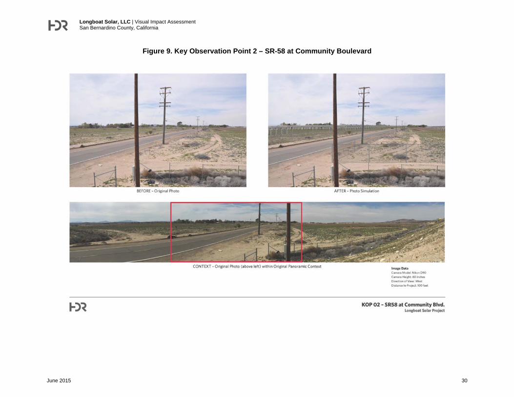
Figure 9 (KOP 2) illustrates the pre- and post-Project views from the eastern edge of the Project site. Existing views from KOP 2 as depicted in Figure 9 reflect the following visual characteristics:
Scenic Attractiveness – (Class C – Indistinctive). This KOP depicts a typical landform that includes vacant land that has been used for agricultural uses with some residences intermixed. This view does not contain background views of the mountains. The view contains several existing visual encroachments including fencing, power poles and lines, Community Boulevard, and disturbed habitat in the foreground view. The landform and vegetation patterns have a low visual quality.
Scenic Integrity – (Low). The views from this KOP include vacant land, agricultural uses, and a few residences. The vegetation in the area consists of disturbed agricultural land with direct roadways and a several rows of non-native trees. The existing tree rows obstruct any views of the ridgelines in the background. There are no distinctive land forms in the surrounding area.
Landscape Visibility - (Immediate Foreground). This KOP contains the Project site in the immediate foreground to the north and south of Community Boulevard.
Constituent Analysis – (Medium) This KOP provides a view from a vehicle driver on a local road and a resident. Considering a local resident would have a prolonged view of the project components, they would have a medium concern level as to changes in the vacant land of the area. In addition, the vehicle driver on a local road would be similar to a resident because they would most likely live in the surrounding area.
As shown in Figure 9, KOP 2, the solar arrays are visible on both side of Community Boulevard. Although the solar arrays are visible, the existing power lines continue to dominate the foreground thereby contributing to the low level of scenic attractiveness of the area. Additionally, there are no background views of the mountains from this KOP that would be obstructed. Additionally, the solar arrays and associated fencing would be set back from Community Boulevard such that a vehicle driver’s view of the Project will be short-term and attenuated in the foreground by the required setbacks (e.g. fencing 15 feet from property line). The solar arrays to the south of Community Boulevard would be punctuated by treetop views in the middleground; thereby retaining these landscape features in the post-Project condition. Additionally, no new utility poles would be required along Community Boulevard. The three new utility poles constructed south of Community Boulevard would be masked by the existing windrows in addition to blending with the existing overhead lines due to their close placement, adjacent to existing utility pole.
Longboat Solar, LLC | Visual Impact Assessment San Bernardino County, California
June 2015 29
Although a few residents would have a prolonged view of the Project site, the existing view has an indistinctive scenic attractiveness with low scenic integrity, and the broad vegetated setback and intervening vegetation obscure viewing of the Project site. For example, the closest property with a potential residence, the Green Valley Foods Product Inc. cheese factory located to the north of Community Boulevard, is separated from the road by a thick windrow that prevents viewing of the Project. Two other nearby residences are owned by individuals who have leased their lands to the project proponent for the duration of the project. With regard to local residences east of SR-58, the existing embankment substantially obstructs views of the Project site from the residential neighborhood located to the east with the exception of a small viewing area at the Community Boulevard overcrossing. The landscape change is, therefore, considered less than significant.
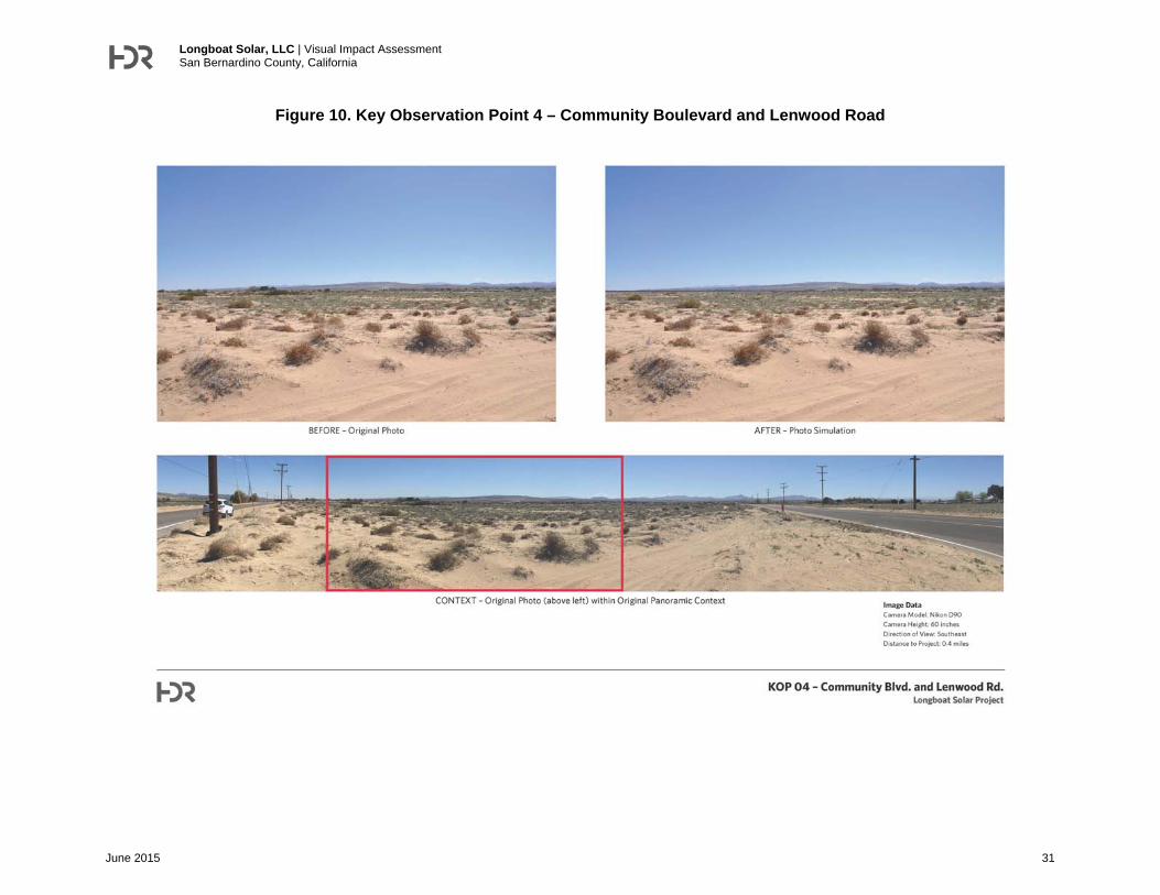
Figure 10 (KOP 4) illustrates the pre- and post-Project views from the intersection of Community Boulevard and Lenwood Road to the west of the Project site. Existing views from KOP 4 as depicted in Figure 10 reflect the following visual characteristics:
Scenic Attractiveness – (Class C - Indistinctive). This KOP depicts a typical landform that includes vacant land that has been previously used for agricultural uses within a desert landscape. The area lacks variety, unity, and uniqueness in the landscape, with no water characteristics or cultural land attributes. The vegetation in the area consists of native and non-native disturbed habitat. No residences or agricultural structures are visible within the immediate surrounding. Shallow, barren hill slopes are visible in the background in the vicinity of Barstow, but lack any distinctive characteristics.
Scenic Integrity – (Very Low). The views from this KOP include vacant land, previously used for agricultural uses, with some areas containing disturbed native habitat in the middleground in the vicinity of the Mojave River. Windrows are visible on the western edge of the Project site in the middleground, but lack any uniformity or visually distinctive characteristics. The landscape character appears to have been moderately altered over time from agricultural uses, although, vegetation appears to be reestablishing in the immediate foreground. This vantage contains background views of the shallow undulating hills and mountains; however, no distinctive land forms in middle- or foreground views.
Landscape Visibility - (Middleground). The western boundary of the Project site is located approximately 0.75 mile from this KOP 4. The Project site would be considered in the middleground view. This view contains some background views of undulating hill slopes.
Constituent Analysis – (Low) This KOP provides a view from a vehicle driver on a local roadway. Although there are no residences directly located at this vantage, there are several residential structures to the south and west of this KOP. Based on the distance of the Project from these locations, the Project’s low profile, and the long duration of viewing, this vantage would have a low constituent concern level to the visual changes in the area.
Longboat Solar, LLC | Visual Impact Assessment San Bernardino County, California
June 2015 30
Figure 9. Key Observation Point 2 – SR-58 at Community Boulevard
Longboat Solar, LLC | Visual Impact Assessment San Bernardino County, California
June 2015 31
Figure 10. Key Observation Point 4 – Community Boulevard and Lenwood Road
Longboat Solar, LLC | Visual Impact Assessment San Bernardino County, California
June 2015 32
As shown in Figure 10, KOP 4, the solar arrays are barely visible in this middleground view and blend in with the tree rows in the background. The vehicles traveling on Lenwood Road and Community Boulevard would barely notice the solar arrays from this distance, if at all. Residences would be subjected to a longer duration of viewing. The three new utility poles constructed south of Community Boulevard and adjacent to the existing pole would blend in with the existing overheads lines and would not be visible. The off-site utility poles, where replaced, would be replaced in kind with similar wooden pole structures. Given the indistinctive scenic attractiveness, the very low scenic integrity, low constituent concern level, and minimal level of visual change as depicted in Figure 10, a less than significant landscape change would result from the Project.
Given that the Project is relatively low in height (less than 12 feet), incorporates non-reflective materials, and largely blends with the existing vegetation and developments in the surrounding area, visual changes as attributable to the Project would be minimal. Therefore, the proposed Project will have a less than significant impact to existing visual character or quality of the site and its surroundings.
4. Would the Project create a new source of substantial light or glare, which would adversely affect day or nighttime views in the area?
The Project is not expected to create a substantial new source of nighttime lighting or daytime glare. The proposed Project will provide external safety lighting for both normal and emergency conditions at the primary access points. Lighting will be designed to provide the minimum illumination needed to achieve safety and security and will be downward facing and shielded to focus illumination in the immediate area. Additionally, the Project will comply with San Bernardino County Code section 84.29.040 which regulates glare, outdoor lighting, and night sky protection. All lighting associated with the proposed Project will be subject to County approval and compliance with San Bernardino County requirements. Therefore, the Project will have a less than significant impact associated with nighttime lighting.
The Project would generally avoid the use of materials such as fiberglass, aluminum or vinyl/plastic siding, and brightly painted steel roofs, which have the potential to create on- and off-site glare impacts. Unlike solar thermal facilities, which rely on large fields of mirrors to reflect light, the potential reflection from solar PV modules used on a tracker mounting system is inherently low due to the materials of its construction and its mode of operation. PV cells are designed to capture (rather than reflect) nearly all sunlight. Reflected light from the surface of standard PV modules is between 10 to 20 percent of the incident radiation (lower than free water and glass surfaces), while steel (used in industrial roofs) is between 40 to 90 percent (Aztec 2014). In addition, because tracker systems follow the sun, the underside of the PV panels and most of the structure supporting them are shadowed throughout the day.
Moreover, light reflected from the PV panels would travel above the line of site of most, if not all, viewers. PV tracking systems position the array so that the sun’s rays are always perpendicular to the face of the panel. What light is reflected from the panels is reflected back towards the sun. During midday conditions, when the sun is high in the sky, the rays of the sun are reflected directly upwards. For example, when the sun is low on the horizon (near dawn or dusk), the
Longboat Solar, LLC | Visual Impact Assessment San Bernardino County, California
June 2015 33
sun's angle in the sky is low; however, reflected rays would still be directed away from ground-level receptors because the maximum downward angle of the arrays would not be below 30 degrees. Similarly, and also due to their low reflectivity, the panels are not expected to cause visual impairment for motorists on area roadways or engineers for passing freight trains. This is because both SR-58 and the railroad are oriented, at relatively flat angle (e.g. less than 5 degrees) and in a south-easterly direction relative to the north and western sides of the Project site. Southeast-bound motorists and train operators would not directly view light reflected westwards from the Project because they would pass the project site both at an oblique angle and well under the angle of refraction (e.g. less than 30 degrees). A similar circumstance would also apply to north- and westbound traffic and train movements.
The Project will comply with San Bernardino County Code section 84.29.040 which states that solar energy facilities shall be designed to preclude daytime glare on any abutting residential land use zoning district, residential parcel, or public right-of-way (County of San Bernardino, 2007a). Compliance with San Bernardino County Code section 84.29.040 will minimize any potential impacts associated with glare to roadway travelers and the adjacent railway. Viewers are not expected to experience substantially increased glare or glint as a result of the Project. Therefore, the proposed Project will have a less than significant impact in terms of light and glare.
Cumulative Impacts The cumulative analysis considers important visual features and viewsheds in the regional vicinity for the Project site.
Visual features in the cumulative study area are limited to surrounding mountains and ridgelines, at distance, and the Mojave River. A list of existing, proposed, and reasonably-foreseeable projects is presented in Table 3, Cumulative Projects. Of all the projects listed in Table 3, the proposed surface waste improvement pond project at the Green Valley Foods facility (the cheese-making facility mentioned previously) and the State Route 58 Hinkley Expressway expansion Project are located within the same general viewshed as the Project site. These projects would not involve any form of solar generation. Additionally, the SR-58 improvements would be constructed to conform to the existing highway grade and within Caltrans’ roadway right-of-way; whereas the Green Valley Foods facility would be contained with the existing development envelop and masked by the existing windrows such that the combined effects of the two projects would not create a significant cumulative impact] Further, there are no cumulative projects, such as other solar or wind generation facilities, proposed in the immediate project area that would result in potential visual resources and aesthetic impacts, and no additional major developments are contemplated in the County General Plan for this area.

Longboat Solar, LLC | Visual Impact Assessment San Bernardino County, California
June 2015 34
Table 3. Cumulative Project List
Project Name/Proponent Project Description Status
Approximate Distance to Project
Lydia Wind (Celtic Energy)
17,011 acre wind generation facility
Testing 3 miles south east of I-15; T80N R20W
Meridian Wind Type II (Bellevue Renewable Power)
44,245 acre wind generation facility
Testing 9 miles north-northwest; T110N R10E
Calico Wind Type II (Bellevue Renewable Power)
28,908 acre wind generation facility
Testing 13 miles east; T100N R10E
Green Valley Foods Improvements
Establish a 90,000 sf surface waste improvement pond.
Unlikely to be built Adjacent to project site
State Route 58 Hinkley Expressway Project (Caltrans)
Widen and realign existing 2-lane SR-58 to 4-lane expressway from 2.4 miles west of Hidden River Road to 0.7 mile east of Lenwood Road.
Project is anticipated to begin 1 June 2015.
Eastern terminus of is approximately 0.25 mile northwest of the northern parcel of project on SR-58.
Martinsville Specific Plan (City of Barstow)
315-acre specific plan for uses including residential and golf course development.
Comes before City of Barstow Planning Commission in March 2015. Negative Declaration proposed.
4 miles to the south. Approximate location: south of Lenwood Road; west of I-15.
Abengoa Mojave Solar Project
280-MW (gross) Parabolic Trough Solar Generating Facility
In Operation 12 miles to the west-northwest (Lockhart, CA)
NREL Solar Electric Generating Stations VIII and IX
178-MW (gross) Parabolic Trough Solar Generating Facility
In Operation 15 miles to the northwest (Lockhart, CA)
Nursery Products, LLC Bio-solids and Greenwaste Composting Facility
In Operation 15 miles to the west (Hinkley, CA)
Sunlight Partners, LLC 4.5-MW Photovoltaic Solar Generating Facility
Permits Issued as of February 2015, construction status unknown.
16 miles to the southwest (Helendale, CA)
NREL Solar Electric Generating Stations I and II
46.8-MW (gross) Parabolic Trough Solar Generating Facility
In Operation 16 miles to the southeast (Daggett, CA)
Sunray Energy 2, LLC 44-MW Solar Generating Facility
Under Review as of February 2015
16 miles to the southeast (Daggett, CA)
Silver Valley 20-MW Solar Generating Facility
Conditionally Approved; No Permits Issued, Time Extension Approved as of February 2015.
18 miles to the northeast (East side of Sunrise Canyon Road, approximately 3.5 miles north of I-15 and Minneola Road)

Longboat Solar, LLC | Visual Impact Assessment San Bernardino County, California
June 2015 35
The proposed project and potential local cumulative projects are located within in an agricultural-urban interface that is characterized as having a general lack of any distinctive visual features, such as varied topography or other topographical features. These factors all contribute to only low to moderate levels of vividness and intactness. The Project site is not located within a scenic vista, and only viewable from SR-58 for a short duration; whereas the Project site would not be visible from SR-66. Additionally, onsite structural features would be no greater than 12 feet in height and, therefore, would not substantially disrupt background views of mountains to the north, south, and east. Likewise, no new off-site utility poles would be required at off-site locations; just their replacement in-kind in limited instances.
Other cumulative projects considered in Table 3 are generally located at distances of greater than three miles from the Project site and would not be visible from the immediate project area, including the KOP vantages included in Figures 6 through 10, as result of this physical separation combined with the Earth’s curvature, intervening topography, and existing visual encroachments, including SR 58. Cumulative projects considered in this analysis are also located within an area that is not identified for its natural scenic beauty or as a designated scenic resource. Therefore, the visual character of the Project area would not be incrementally, altered qualitatively by the projects listed in Table 3.
Also, the projects considered in Table 3 would not incrementally contribute to substantial amounts of light and glare in the immediate Project area, as none of these projects would involve the placement of significant sources of light or glare in the immediate Project area. Additionally, each project will be subject to the County’s lighting ordinance in addition to federal regulations on BLM lands. Further, the Project would not create a landform modification that could otherwise introduce cumulatively considerable sources of light and glare. Based on these considerations, the Project will not make a considerable contribution to a significant cumulative aesthetic impact.

Longboat Solar, LLC | Visual Impact Assessment San Bernardino County, California
June 2015 36
References Aztec Engineering and Tecnoma. 2014. Iris Cluster Aesthetics Study. July 2014.
California Department of Conservation, Office of Mine Reclamation online database. Accessed March 25, 2015. http://maps.conservation.ca.gov/mol/mol-app.html
California Department of Transportation (Caltrans). The History of Interstate Highways in California. Accessed March 24, 2014. http://www.dot.ca.gov/interstate/CAinterstates.htm
City of Barstow. Barstow General Plan 2007. http://www.barstowca.org/city-hall/city-departments/community-development-department/planning/draft-general-plan-and-master-environmental-impact-report
County of San Bernardino Development Code. 2007. Amended January 15, 2015. Accessed March 24, 2015. http://cms.sbcounty.gov/lus/Planning/DevelopmentCode.aspx
County of San Bernardino General Plan. 2007. Amended April 24, 2014. Accessed March 24, 2015. http://cms.sbcounty.gov/lus/Planning/GeneralPlan.aspx
U. S. Forest Service (USFS). 1995. Landscape Aesthetics. A Handbook for Scenery Management. Agriculture Handbook No. 701. December 1995.