lower duwamish waterway source control action plan for the
TRANSCRIPT
Lower Duwamish Waterway Source Control Action Plan for the
Terminal 117 Early Action Area
July 2005
Publication No. 05-09-093 Printed on recycled paper

This report is available on the Department of Ecology home page on the World Wide Web at http://www.ecy.wa.gov/biblio/0509093.html
For a printed copy of this report, contact:
Department of Ecology Publications Distributions Office Address: PO Box 47600, Olympia WA 98504-7600
E-mail: [email protected] Phone: (360) 407-7472
Refer to Publication Number 05-09-093
If you have special accommodation needs or require this document in alternative format, please call reception at (360) 407-6404. The TTY number is 711 or 1-800-833-6388.

Lower Duwamish Waterway Source Control Action Plan for the
Terminal 117 Early Action Area
Produced by Dan Cargill
Toxics Cleanup Program Northwest Regional Office
Washington State Department of Ecology Bellevue, Washington
With Assistance from:
City of Seattle Port of Seattle King County
U. S. Environmental Protection Agency and
Science Applications International Corporation 18912 North Creek Parkway, Suite 101
Bothell, WA 98011
July 2005
Waterbody No. WA-09-1010
Publication No. 05-09-093


Page i
Table of Contents Page
Abstract .......................................................................................................................................... iii Acknowledgements........................................................................................................................ iv Acronyms/Abbreviations ................................................................................................................ v Lower Duwamish Waterway Site ................................................................................................... 1
Lower Duwamish Waterway Source Control Strategy..............................................................5 Terminal 117 Early Action Area..................................................................................................... 7
Chemicals of Concern................................................................................................................8 Potential Sources of Recontamination of Terminal 117 EAA Sediments .................................... 10
Piped Outfalls...........................................................................................................................10 Direct Stormwater Discharges .................................................................................................12
Port of Seattle Terminal 117............................................................................................12 South Park Marina...........................................................................................................14 Boeing South Park...........................................................................................................15 Port of Seattle Terminal 117............................................................................................16 Basin Oil Company .........................................................................................................18 Dallas Avenue South Vicinity Contamination ................................................................19 South Park Marina...........................................................................................................20 Boeing South Park...........................................................................................................23 Other Upland Contaminated Sites ...................................................................................23
Source Control Actions Specific to Terminal 117........................................................................ 28 City of Seattle Actions .............................................................................................................28
Basin Oil ..........................................................................................................................28 Dallas Avenue South Cleanup.........................................................................................28
Port of Seattle Actions .............................................................................................................30 Terminal 117 Stormwater Protection ..............................................................................30 Terminal 117 Early Action Area Removal......................................................................30
Ecology Actions.......................................................................................................................32 Upland Contaminated Sites .............................................................................................32
Source Identification and Tracing............................................................................................33 Post Cleanup Sediment Monitoring .........................................................................................33
Tracking and Reporting of Source Control Activities .................................................................. 34 References..................................................................................................................................... 35 Appendix A................................................................................................................................... 39 Terminal 117 Early Action Sediment Cleanup – Source Control Actions ................................... 39

Page ii
List of Figures and Tables Page
Figures
Figure 1. Lower Duwamish Waterway Study Area........................................................................ 2 Figure 2. Early Action Areas .......................................................................................................... 4 Figure 3. Terminal 117 Site Vicinity .............................................................................................. 9 Figure 4. Terminal 117 Vicinity Storm and Sanitary Sewers....................................................... 11 Figure 5. Site Drainage Map......................................................................................................... 13 Figure 6. PCB Soil Sampling Locations ....................................................................................... 21 Figure 7. Dallas Avenue South and Vicinity PCB Soil Sampling Locations ............................... 22 Tables Table 1 Dallas Avenue South and Vicinity Sample...................................................................... 24 Table 2 Dallas Avenue South Untreated Run-off ......................................................................... 29

Page iii
Abstract The Lower Duwamish Waterway is located in Seattle, Washington, and is approximately five miles long. The U.S. Environmental Protection Agency (EPA) added the waterway to the Superfund list on September 13, 2001. Chemicals of concern found in waterway sediments include polychlorinated biphenyls (PCBs), polycyclic aromatic hydrocarbons (PAHs), mercury and other metals, and phthalates. These chemicals of concern may pose threats to people, fish, and wildlife.
In December 2000, EPA and the Washington State Department of Ecology (Ecology) entered into an order with King County, the Port of Seattle, the City of Seattle, and The Boeing Company to perform a Remedial Investigation and Feasibility Study (RI/FS) of sediment contamination in the waterway. The EPA is the lead agency for the RI/FS. Ecology is the lead agency for controlling current sources of pollution to the site, in cooperation with the City of Seattle, King County, the Port of Seattle, the City of Tukwila, and the EPA.
Phase 1 of the RI/FS used existing data to identify potential human health and ecological risks, information needs, and high priority areas for cleanup (early action areas). The Terminal 117 Early Action Area (EAA) is one of seven EAAs selected by EPA and Ecology.
This Source Control Action Plan (Action Plan) describes potential sources of contamination that may affect sediments adjacent to Terminal 117. The plan also describes actions that will be taken, or are underway, to address identified sources; sampling and monitoring that will be used to identify sources and assess progress; and how these efforts will be tracked and reported.
Page iv
Acknowledgements The Department of Ecology would like to thank the members of the interagency Lower Duwamish Waterway Source Control Work Group for their contributions and support in developing this Action Plan:
Doug Hotchkiss, Port of Seattle, Senior Environmental Program Manager
Marilyn Guthrie, Port of Seattle, Senior Environmental Program Manager
Beth Schmoyer, PE, Seattle Public Utilities
Kristine A. Flint, Region 10, U.S. EPA Environmental Cleanup Division
Richard Thomas, Washington State Department of Ecology, Toxics Cleanup Program
Richard Huey, Washington State Department of Ecology, Toxics Cleanup Program
Elsie Hulsizer, King County Wastewater Treatment Division, Industrial Waste Program Manager

Page v
Acronyms/Abbreviations AST – Aboveground Storage Tank
BMP – Best Management Practice
BTU – British Thermal Unit
CERCLA – Comprehensive Environmental Response Compensation Liability Act (Superfund)
CSCS – Confirmed or Suspected Contaminated Sites
CSL – Cleanup Screening Level (Washington State Sediment Management Standards)
CSO – Combined Sewer Overflow
DW – Dry Weight
EAA – Early Action Area
Ecology – Washington State Department of Ecology
EE/CA – Engineering Evaluation/Cost Analysis
EPA – United States Environmental Protection Agency
LDWG – Lower Duwamish Waterway Group
LUST – Leaking Underground Storage Tank
MLLW – Mean Lower Low Water
MTCA – Washington State Model Toxics Control Act
NAPL – Non-Aqueous Phase Liquid
NPDES – National Pollutant Discharge Elimination System
NTCRA – Non-Time-Critical Removal Action
PAHs – Polycyclic Aromatic Hydrocarbons
PCBs – Polychlorinated Biphenyls
PVC – Polyvinyl Chloride
RI/FS – Remedial Investigation and Feasibility Study
ROD –Record of Decision
SCWG – Source Control Work Group
SPU – Seattle Public Utilities
SQS – Sediment Quality Standard (Washington State Sediment Management Standards)
SWPPP – Stormwater Pollution Prevention Plan
TSCA – Toxic Substances Control Act
UST – Underground Storage Tank

Page vi
Page 1
Lower Duwamish Waterway Site The Lower Duwamish Waterway is the downstream portion of the Duwamish River, and extends from the southern tip of Harbor Island to just south of Turning Basin 3 (Figure 1). It serves as a major shipping route for bulk and containerized cargo. Most of the upland areas adjacent to the Lower Duwamish Waterway have been developed for industrial and commercial operations. These include cargo handling and storage, marine construction, boat manufacturing, marina operations, concrete manufacturing, paper and metals fabrication, food processing, and airplane parts manufacturing. In addition to industry, the river is used for recreational, tribal and subsistence fishing, recreation, and wildlife habitat. Residential areas near the waterway include the South Park and Georgetown neighborhoods (Windward 2003a).
Beginning in 1913, this portion of the Duwamish River was dredged and straightened to facilitate navigation and industrial development, resulting in the current configuration. Shoreline features within the waterway include constructed bulkheads, piers, wharves, buildings extending over the water, and steeply sloped banks armored with riprap or other fill materials (Weston 1999). This development left intertidal habitats dispersed in relatively small patches, with the exception of Kellogg Island, which is the largest contiguous area of intertidal habitat remaining in the Duwamish River (Tanner 1991). Over the past 20 years, public agencies and volunteer organizations have worked to restore intertidal and subtidal habitat to the river. Some of the largest restoration projects are at Herring House Park/Terminal 107, Turning Basin 3, Hamm Creek, and Terminal 105.
The presence of chemical contamination in the Lower Duwamish Waterway has been recognized since the 1970s (Windward 2003a). In 1988, the U.S. Environmental Protection Agency (EPA) investigated sediments in the Lower Duwamish Waterway as part of the Elliott Bay Action Program. Problem chemicals identified by the EPA study included metals, polycyclic aromatic hydrocarbons (PAHs), polychlorinated biphenyls (PCBs), phthalates, and other organic compounds. In 1999, EPA completed a study of approximately six miles of the waterway, from the southern tip of Harbor Island to just south of the turning basin near the Norfolk combined sewer overflow (Weston 1999). This study confirmed the presence of PCBs, PAHs, phthalates, mercury, and other metals. These chemicals may pose threats to people, fish, and wildlife.
In December 2000, EPA and the Washington State Department of Ecology (Ecology) signed an agreement with King County, the Port of Seattle, the City of Seattle, and the Boeing Company, collectively known as the Lower Duwamish Waterway Group (LDWG). Under the agreement, the LDWG is conducting a Remedial Investigation and Feasibility Study (RI/FS) of the Lower Duwamish Waterway to assess potential risks to human health and the environment and to evaluate cleanup alternatives. The Remedial Investigation for the site is being done in two phases. Results of Phase 1 were published in July 2003 (Windward 2003a). The Phase 1 RI used existing data to provide an understanding of the nature and extent of chemical distributions in Lower Duwamish Waterway sediments, develop preliminary risk estimates, and identify candidates for early cleanup action. The Phase 2 RI is currently underway and is designed to fill critical data gaps identified in Phase 1. Based on the results of the Phase 2 RI, additional areas for cleanup may be identified. During Phase 2, a Feasibility Study will be completed that will address cleanup options for contaminated sediments in the Lower Duwamish Waterway.

Page 2
Figure 1. Lower Duwamish Waterway Study Area
Page 3
On September 13, 2001, EPA added the Lower Duwamish Waterway to the National Priorities List. This is EPA’s list of hazardous waste sites that warrant further investigation and cleanup under Superfund. Ecology added the site to the Washington State Hazardous Sites List on February 26, 2002. An interagency Memorandum of Understanding signed by EPA and Ecology in April 2002 and updated in April 2004, divides responsibilities for the site (EPA and Ecology 2002, EPA and Ecology 2004). EPA is the lead for the RI, while Ecology is the lead for source control issues.
In June 2003, the Technical Memorandum: Data Analysis and Candidate Site Identification, Final (Windward 2003b) was issued. Seven candidate sites for early action were recommended (Figure 2). The sites are:
• Area 1: Duwamish/Diagonal combined sewer overflow (CSO) and storm drain
• Area 2: River mile (RM) 2.2, on the west side of the waterway, just south of the 1st Avenue South Bridge
• Area 3: Slip 4 (RM 2.8)
• Area 4: South of Slip 4, on the east side of the waterway, just offshore of the Boeing Plant 2 and Jorgensen Forge properties (RM 2.9 to 3.7)
• Area 5: Terminal 117 and adjacent properties, located at approximately RM 3.6, on the west side of the waterway
• Area 6: RM 3.8, on the east side of the waterway
• Area 7: Norfolk CSO (RM 4.9 – 5.5), on the east side of the waterway
To date, EPA and Ecology have selected four of the candidate sites for early cleanup action: Terminal 117 (the subject of this Action Plan), Slip 4, Boeing Plant 2, and Duwamish/Diagonal Way. EPA is the lead for managing cleanup at Terminal 117 and Slip 4. The other two early action cleanup projects were started before the current Lower Duwamish Waterway RI/FS was initiated. Boeing Plant 2 (under EPA management) is currently in the planning stage. The Duwamish/Diagonal Way cleanup (under King County management as part of the Elliott Bay-Duwamish Restoration Program), was partially completed in March 2004. The remaining sites may be selected by the agencies for early action cleanup or they may be deferred to the Phase 2 study for further consideration. Early action cleanups will involve members of the LDWG and other parties as appropriate. Planning and implementation of priority early action cleanups will be done concurrently with Phase 2 investigation work.
Further information about the Lower Duwamish Waterway can be found at: http://yosemite.epa.gov/r10/cleanup.nsf/sites/lduwamish

Page 4
Figure 2. Early Action Areas

Page 5
Lower Duwamish Waterway Source Control Strategy The Lower Duwamish Waterway Source Control Strategy (Ecology 2004) describes the process for identifying source control issues and implementing effective controls for the Lower Duwamish Waterway. The basic plan is to identify and manage sources of potential recontamination in coordination with sediment cleanups. The goal of the strategy is to minimize the potential for recontamination to levels exceeding the Lower Duwamish Waterway sediment cleanup goals and the Sediment Management Standards (WAC 173-204). Existing administrative and legal authorities will be used to perform inspections and require necessary source control actions.
The strategy will be implemented through the development of a series of detailed, area-specific Action Plans that will be coordinated with sediment cleanups, beginning with the Early Action Areas (EAAs). The Action Plans will document what is known about the area, potential sources of recontamination and actions to address them, and when adequate source control is achieved for an area. Because the scope of source control for each site will vary, it will be necessary to adapt each plan to specific situations. The success of this strategy depends on the coordination and cooperation of all public agencies with responsibility for source control in the Lower Duwamish Waterway area, as well as prompt compliance by the businesses that must make necessary changes to control releases from their properties.
The focus of the strategy is on controlling contamination that affects Lower Duwamish Waterway sediments. It is based on the principles of source control for sediment sites described in EPA’s Principles for Managing Contaminated Sediment Risks at Hazardous Waste Sites; EPA, February 12, 2002, and Ecology’s Sediment Management Standards (WAC 173-204). The first principle is to control sources early, starting with identifying all ongoing sources to the site. EPA’s Record of Decision (ROD) for the site will require that sources of sediment contamination to the entire site be evaluated, investigated, and controlled as necessary. Dividing source control work into specific Action Plans and prioritizing those plans to coordinate with sediment cleanups will address the guidance and regulations and will be consistent with the EPA ROD.
Source control priorities are divided into four tiers. Tier One consists of source control work associated with the EAAs identified to date. Tier Two consists of source control work associated with any final, long-term sediment cleanup actions identified through Phase 2 Remedial Investigation work, and the EPA ROD. Tier Three consists of source identification and potential source control work in areas of the waterway that are not identified for cleanup, but where source control may be needed to prevent future contamination. Tier Four consists of control work identified by post-cleanup sediment monitoring (Ecology 2004). This document is a Tier One Source Control Action Plan for an early action sediment cleanup.

Page 6
Source Control Work Group
The primary public agencies responsible for source control for the Lower Duwamish Waterway are Ecology, the City of Seattle, King County, Port of Seattle, City of Tukwila, and the EPA. Other public agencies with relevant source control responsibilities include the Washington State Department of Transportation, Puget Sound Clean Air Agency, and the Public Health Seattle-King County. These agencies are invited to participate as appropriate (Ecology 2004).
In order to coordinate among these agencies, Ecology formed the Source Control Work Group (SCWG) in January 2002. The purpose of the SCWG is to share information, discuss strategy, actively participate in developing Action Plans, jointly implement source control measures, and share progress reports on source control activities for the Lower Duwamish Waterway area. SCWG meetings are chaired by Ecology and are held monthly. All final decisions on source control actions and completeness will be made by Ecology, in consultation with EPA, as outlined in the April 2004 EPA/Ecology Lower Duwamish Waterway Memorandum of Understanding (EPA and Ecology 2004).
The agencies involved in source control efforts at the Terminal 117 EAA are the Port of Seattle, City of Seattle, EPA and Ecology. Because the City of Tukwila has no jurisdiction over the areas that drain to the Terminal 117 EAA, and there are no King County combined sewer outfalls or emergency overflows in the immediate vicinity of Terminal 117, they are not included in this Action Plan.

Page 7
Terminal 117 Early Action Area Terminal 117 is located on the west side of the Lower Duwamish Waterway (Figure 2) from approximately RM 3.5 to 3.7, as measured from the southern tip of Harbor Island. The Terminal covers approximately 2.9 acres including a 50-foot- to 60-foot-wide section of land adjacent to the shoreline, which is owned by the Port of Seattle as successor in interest to the King County Commercial Waterway District No. 1. In 1999, the Port of Seattle acquired the additional inland parcels owned by the Malarkey Asphalt Company. These properties were consolidated to form the present-day Terminal 117 property.
The Terminal 117 EAA generally consists of the intertidal zone from the top of the shoreline bank (+13 feet) to -4 feet mean lower low water (MLLW) and a subtidal zone, from -4 feet MLLW to the slope of the navigation channel at -9 feet MLLW. It is bordered by South Park Marina to the north, Boeing to the south, and the Terminal 117 upland property to the west.
The Terminal 117 upland property covers approximately 1.9 acres of land consisting of land above +13 feet MLLW and extending west to Dallas Avenue South
The Duwamish Manufacturing Company began asphalt manufacturing operations at the site around 1937 and continued until 1978 (URS 1994). In 1978, the property was purchased by MCW, Inc. and roofing asphalt manufacturing continued (URS 1994). MCW, Inc. later changed its name to Malarkey Asphalt Company and continued asphalt manufacturing operations until 1993.
In the 1950s, the U.S. Army Corps of Engineers (USACE) may have used the T-117 shoreline area to deposit dredge material generated from the LDW (URS 1994). Michael Malarkey, owner of Malarkey Asphalt, also noted that in the 1950s, during the early asphalt manufacturing operations, USACE dredged the LDW channel and deposited the dredged material, which may have contained heavy metals and other contaminants, on the banks of the LDW (URS 1994). Ecology records also indicate additional dredged material disposal in the vicinity of T-117 sometime in the 1970s (Atkins 1991). In the early 1970s, Duwamish Manufacturing used waste oil that contained PCBs. Sampling results from past site inspections indicated high levels of PCBs in soil, groundwater, and sediments.
In 1999, the Port of Seattle conducted a Comprehensive Environmental Response Compensation Liability Act (CERCLA) Removal Action according to a work plan approved by EPA (Onsite 1999). The Port removed and contained PCB-contaminated soil in part of the upland portion of Terminal 117 in the fall of 1999 (Onsite 2000). The work included the removal and treatment of impounded stormwater, excavation and disposal of over 2,000 tons of PCB-contaminated soil, backfilling the excavation, installation of storm drain improvements, and paving the site, including areas where there has been limited or no characterization and removal. The completion of this work resulted in the present-day configuration of the property.
Adjacent properties include the Basin Oil Company on the west side of Dallas Avenue South, the Boeing Company to the south, and the South Park Marina to the north/northwest. The City owns the adjacent street rights-of-way, including Dallas Avenue South (between the Basin Oil prop-erty and Terminal 117). There are two private residences across the street from Terminal 117.
Page 8
Chemicals of Concern The most prevalent chemical exceeding the cleanup screening level (CSL) in sediments is total PCBs. Based on historical data, this site was listed for early action in Phase 1 of the remedial sediment investigations. Phenol exceeding its CSL and PAHs above the SQS and CSL have also been detected in the Terminal 117 EAA sediments. Butyl benzyl phthalate, bis (2-ethylhexyl) phthalate and DDT (total calculated) exceeded the Sediment Quality Standards (SQS). Undetected values of hexachlorobenzene, 1,2-dichlorobenzene, 1,2,4- trichlorobenzene, and dieldrin also exceeded the SQS, and while the methods used to determine concentrations of these chemicals had high detection limits, they are generally accepted to be adequate (Windward et al. 2003). Total PCB concentrations in samples collected in the bank ranged from 5 to 200 mg/kg dry weight (Windward et.al. 2004).
Inspections and site investigations conducted by King County (METRO), Ecology, EPA, and the Port of Seattle since 1984 have identified upland soils and catch basin sediments contaminated with PCBs, PAHs, pentachlorophenol, phenol, benzoic acid, benzyl alcohol, lead, arsenic, zinc, cadmium, and silver. Source control efforts will look for ongoing sources of these as well as any other chemicals that could recontaminate sediments.

Page 9
Figure 3. Terminal 117 Site Vicinity

Page 10
Potential Sources of Recontamination of Terminal 117 EAA Sediments
Piped Outfalls There are three types of systems that carry municipal/industrial wastewater and stormwater away from homes and businesses in the Lower Duwamish Waterway area. These are referred to as the sanitary, combined sewer, and storm drain systems. Sanitary sewers carry only wastewater from homes and businesses. Combined sewers carry both wastewater and stormwater (runoff from roadways, parking lots, rooftops, and yards) in a single pipe. Sanitary and combined sewer flows go to the West Point wastewater treatment plant on Puget Sound. During heavy rainfall, when the combined sewers have reached their capacity, the combined sewer system may have a “CSO event” where discharges of stormwater, industrial wastewater, and sewage are released untreated into the waterway; these discharges may contain pollutants that could recontaminate sediments. Storm drains carry only stormwater runoff and may carry pollutants that could recontaminate sediments from roads, parking lots, and other surfaces, as well as materials illicitly discharged to the drainage system from businesses and residences. Most of the waterfront properties immediately adjacent to the Lower Duwamish Waterway are served by privately owned storm drain systems that discharge directly to the waterway.
Only privately owned storm drains that serve the immediate waterfront properties discharge to the waterway near Terminal 117. There are currently no municipal storm drain or CSO outfalls that discharge to the waterway in the vicinity of the Terminal 117 EAA.
Except for a short section near the intersection of 16th Avenue South, there are no sanitary sewers along Dallas Avenue South. Generally, properties east of 17th Avenue South and north of Dallas Avenue South use septic tanks with drain fields. Basin Oil and the Terminal 117 facility are both on septic systems. The north end of the South Park Marina is connected to the City sewer system, but the south end may be on a septic system. Areas west of 17th Avenue South and south of Dallas Avenue South are connected to the City’s combined sewer system. Stormwater and sewage from these areas is collected and conveyed to the West Point wastewater treatment plant. In the event of a CSO, the outfall for the sewers in this area is located at 8th Avenue South, approximately ¾ mile downstream of the site.
Runoff from about a 6-acre area (including the Terminal 117 facility) used to discharge to the Terminal 117 EAA. Because there was no public storm drainage system in this area and because the streets were in poor condition, runoff typically ponded in the right-of-way or ran off onto adjacent properties. The primary route to the waterway was across the south end of the Terminal 117 facility. Runoff from the adjacent streets either sheet flowed across the driveway entrance or was picked up in a catch basin near the south entry to Terminal 117 and was discharged to the Duwamish Waterway.

Page 11
Figure 4. Terminal 117 Vicinity Storm and Sanitary Sewers

Page 12
In December 2004, the City of Seattle completed an interim cleanup action to contain PCBs present in the road rights-of-way. A temporary stormwater collection and treatment system was installed as part of the cleanup action. Runoff from most of the adjacent roadways and the Basin Oil property (about 1.8 acres), was collected, conveyed to a temporary stormwater system on South Donovan Street, and discharged at a controlled rate to the City combined sewer system. The treatment system was removed in March 2005 after testing showed that treatment was not necessary because PCB levels in stormwater run-off were below the limits for discharging into the sanitary sewer. The EAA cleanup, which includes the removal of contaminated bank material and the redesign of the bank, may include a new stormwater discharge to the Lower Duwamish Waterway in the vicinity of Terminal 117.
Direct Stormwater Discharges Stormwater runoff is a potential pathway for upland contaminants coming from the Terminal 117 area to enter the Lower Duwamish Waterway. Contaminants may come from accidental releases of spilled materials, industrial residues, soil contaminants suspended as particulates in stormwater runoff, and dissolved-phase contaminants in runoff from historical or present-day industrial/commercial sources.
Port of Seattle Terminal 117
The locations of catch basins, connecting culverts, and surface drainage pathways associated with Terminal 117 are shown in Figure 5. Drainages on the streets adjacent to Terminal 117 were modified by the City’s interim action (December 2004), and the runoff previously entering the terminal area and flowing east to catch basin 5 is now being intercepted and discharged to the combined sewer system on South Donovan Street.
Runoff from the northern area of Terminal 117 flows to catch basin 1, which discharges to the waterway through a 6-inch outfall located within the riprap on the bank. Runoff from the central interior of the terminal flows to the central catch basin 2 and discharges through a 3½-inch iron pipe onto the paved area immediately east of the retaining wall, then flows overland to nearby catch basin 3. Catch basin 3 discharges through a 6-inch underground pipe to catch basin 4 serving the south portion of the “roadway” area, which then discharges to the south catch basin 5. Prior to December 2004, catch basin 5 also received runoff from the southern portion of Terminal 117 as well as stormwater flowing onto the terminal from Dallas Avenue South, Basin Oil, the east end of South Donovan Street, and catch basin 6. The outfall for catch basin 5 discharges through the shoreline berm to the riprap. All of the catch basins on Terminal 117 include sumps for retaining settled solids. There is a 20-foot-long trench drain along the west doorway of the large metal building at the south end of Terminal 117. This drain, which received runoff from the east terminus of South Donovan Street, discharges into catch basin 6. The discharge for this catch basin runs along the north side of the building, discharges to the paved area at the east end of the building, and then flows overland to catch basin 5.
Portions of the property are currently leased by two tenants. International Inspection occupies the office building on the site. Second Use Building Materials leases part of the warehouse and yard. The Port uses part of the warehouse for its own storage needs. Basin Oil Company leased part of the warehouse on the southern edge of the property until early 2004.

Page 13
Figure 5. Site Drainage Map

Page 14
South Park Marina
Wastes typically generated by boatyard activities (though not necessarily present at the South Park Marina) include spent abrasive grits, spent solvent, spent oils, pressure wash wastewater, paint overspray, paint drips, various cleaners and anti-corrosive compounds, paint chips, scrap metal, welding rods, wood, plastic, resins, glass fibers, and miscellaneous trash such as paper and glass (Ecology 2002). These wastes may enter the wastewater stream through the application and preparation of paints and the painted surface; handling and storage, and accidental spills of chemicals; leaks or drips of paints, solvents, and thinners; fracturing and breakdown of abrasive grits; and repair and maintenance of mechanical equipment. Hull preparation for painting generally involves sanding, grinding, or scraping, and some abrasive blasting. Compared to a shipyard, boatyards are relatively small generators of spent grits, paint chips, and particulate debris. The primary source of wastewater from boatyards is typically stormwater runoff.
Secondary sources are pressure washing, cooling water, pump testing, gray water, sanitary waste, work area washing, and engine bilge water. Engine room bilge water and oily wastes generated at boatyards are typically collected and disposed of through a licensed contracted disposal company.
Pressure wash wastewaters at northwest marinas have been sampled by Ecology, local shipyards and boatyards, and King County. The effluent quality has been highly variable and frequently exceeds fresh and marine water quality criteria for copper, lead, and zinc. Two prime sources of copper at marinas are leaching of copper from anti-fouling paint, and wastes from hull maintenance. The general boatyard permit prohibits direct discharge of pressure wash wastewaters and calls for closed loop systems or other modes of discharge than to surface waters.
South Park Marina, located north of Terminal 117 at 8604 Dallas Avenue South, is a small boat marina and do-it-yourself boat maintenance and repair facility. Since 1970, marina activities have included upland offices, boat repair, cleaning facilities, upland boat storage, boat haul-out services, a boat-launching ramp, and moorage slips in the Lower Duwamish Waterway (Crow 2004). In the mid-1950s the property included the site of A & B Barrel Co., which reconditioned and repainted used barrels and drums, using about one ton of sodium hydroxide per month as a cleaning agent. Liquid waste, including oils, grease, and sodium hydroxide, were discharged to a small pond and then to the Duwamish (Harper-Owes 1983). According to a drawing included with a National Pollutant Discharge Elimination System (NPDES) permit application for the marina, a mobile home park occupied the north half of the present-day marina site in the early 1990s (Ecology 1993).
South Park Marina Operations
The South Park Marina operates a closed loop pressure boat wash system in the southeast portion of the facility. No abrasive blasting is allowed. Boats are cleaned with a high pressure or low pressure water wash. The wash water runs to a catch basin where it is pumped to a water treatment system to remove suspended particles. The water passes through a series of weirs and filters and is reused for the pressure washers. The sludge generated by the process is dried, bagged and disposed as solid waste.
Page 15
The wash system is located in the vicinity of a catch basin that flows to a 3,000-gallon oil/water separator. The catch basin is covered with a metal plate when boat washing is conducted. Stormwater is collected in two catch basins, passed through the oil-water separator, then discharged to the Lower Duwamish Waterway through an outfall near the boat haul-out crane. The marina is required to and has been sampling and analyzing the discharge for oil and grease, total recoverable copper, and total suspended solids as required under its NPDES permit. None of the discharge monitoring reports in Ecology records indicated the water quality monitoring parameters were exceeded. There are four or five additional catch basins located throughout the boatyard and it is presently unclear where these basins ultimately discharge. Runoff from boat maintenance areas can potentially contain a number of chemicals, although PCBs would not be expected to be present in the runoff. The marina enforces stormwater Best Management Practices (BMPs), including the use of vacuum sanders, tarps to catch debris, and routine sweeping of boat maintenance areas. The north end of the South Park Marina is connected to the City sewer system, but the south end may be on a septic system. The sewer connections will be confirmed, the discharge locations of the other catch basins on the site, as well as condition and maintenance practices for the septic system when the site is inspected.
At the South Park Marina, the use of stormwater BMPs, the closed-loop wash system, and the ongoing NPDES monitoring should provide good source control mechanisms for potential industrial/commercial discharges to the Lower Duwamish Waterway from upland sources.
South Park Marina – Boat Storage
The property located at the southeast corner of 16th Avenue South and Dallas Avenue South is currently used by South Park Marina for additional dry boat storage. Since activities at this location are limited to storage, there is little potential for chemicals such as those associated with boat washing or maintenance activities to be generated and enter surface water, groundwater, or soil. While some drainage from this location may flow onto Dallas Avenue South, most of the runoff likely enters the on-site catch basin and the City of Seattle’s catch basins on 16th Avenue South. These connect to the combined sewer on South Cloverdale Street.
Boeing South Park
Boeing South Park is a 27-acre light industrial facility owned and operated by The Boeing Company. The site is entirely covered with either buildings or pavement. The facility has housed various training, information technology, and research functions since it was constructed in the early 1950s (Ecology 1987).
The Boeing South Park facility used to have an NPDES permit for the discharge of non-contact cooling water from air conditioning systems and parking lot runoff via a storm drain. The cooling water discharge was discontinued in 1993 and re-routed to the sanitary sewer system (Boeing 1993).
Stormwater discharges are currently covered under the NPDES General Permit SO3001009D. Parking lot drainage is discharged through one outfall at the north end of the Boeing property. Based on the available background information reviewed, there are no indications that this property has been or is currently a source of PCBs to sediments.

Page 16
Upland Contaminated Sites
Port of Seattle Terminal 117
The Duwamish Manufacturing Company began making roofing asphalt at this site around 1937 and continued until 1978 (URS 1994). The company owned the west half of the present-day Terminal 117, known as parcels “A and B.” The company also used the Port-owned land east of their property and adjacent to the Duwamish Waterway. In 1978, the facility was purchased by Michael O. Malarkey (URS 1994). Malarkey Asphalt Company continued manufacturing roofing asphalt at the site until 1993. The Malarkey parcels were sold to Duwamish Properties, which leased the facility to Evergreen West Wholesale Lumber Inc. for untreated lumber storage and loading operations. The facility was subsequently sold to the Port. The Port combined the Malarkey property with their land adjacent to the Duwamish to form the present-day Terminal 117.
In the 1950s, the U.S. Army Corps of Engineers (USACE) may have used the T-117 shoreline area to deposit dredge material generated from the LDW (URS 1994). Michael Malarkey, owner of Malarkey Asphalt, also noted that in the 1950s, during the early asphalt manufacturing operations, USACE dredged the LDW channel and deposited the dredged material, which may have contained heavy metals and other contaminants, on the banks of the LDW (URS 1994). Ecology records also indicate additional dredged material disposal in the vicinity of T-117 sometime in the 1970s. (Atkins 1991).
During the Malarkey Asphalt Company operations, the raw material for making roofing tar (asphalt flux) was received from the Chevron facility at Richmond Beach, Washington (URS 1994). The flux was heated to approximately 500 °F to drive off light-end hydrocarbons. An estimated 500–600 gallons of these light oils were generated (vaporized) off the stills per month. A fume incinerator/afterburner was operated to burn the vaporized oil. Once the targeted physical properties were achieved, the asphalt was transferred from the stills to various tanks and cooled. A hot oil heater was operated 24 hours per day to keep hot oil circulating through jacketed piping to prevent the asphalt from hardening in product lines and storage tanks (EMCON 1996). An “unlined holding” pond referred to in some reports was actually a depression in the shoreline roadway area where non-contact cooling water and oily run-off from the stills collected. In periods of rain, the water in the pond flowed over the bank and into the Duwamish (Onsite 1999).
During the Arab oil embargo in the early 1970s, the facility reportedly received approximately 1,000 gallons (gal) per month of waste oil, including polychlorinated biphenyl (PCB)-contaminated waste oil from Seattle City Light (URS 1994). The waste oil was used as fuel for the on-site hot oil heaters, a practice that apparently continued until the oil embargo was lifted and oil prices stabilized (Hart Crowser 1992; URS 1994). Oil placed in a partially buried former railroad tank car on-site was also reportedly from Seattle City Light (URS 1994).
Inspections by Metro and Ecology between 1984 and 1986 found extensive oil staining of the property from a variety of sources including leaks from trucks, piping and equipment, spills from oil and product transfers, overfilling of tanks, including the rail car and oils carried by non-contact cooling water from the processing and storage tank secondary containment (URS 1994).

Page 17
In the fall of 1999, the Port of Seattle conducted a CERCLA removal action under an EPA order to remove and contain PCB-contaminated soil in the pond area adjacent to the river as well as selective removal and capping of soil in the former Malarkey plant area (Onsite 1999, Onsite 2000). The work performed in 1999 included the removal and treatment of impounded stormwater in the “roadway pond” area, excavation and disposal of over 2,000 tons of PCB-contaminated soil, backfilling the excavation, installation of storm drain improvements, and site paving. The soil removal criterion for the project was 25 mg/kg PCBs. The excavation plan relied on previous borehole testing performed by SECOR to define the required depths and areas of removal. Verification testing was performed in soil removal grids where PCB concentrations in the deepest SECOR borings still exceeded the removal criterion. Soil was removed and the excavation tested and, if necessary, excavated deeper until the removal criterion was met. The 25 mg/kg target may not have been met in two areas, leaving elevated levels of PCBs at depth. Grid A-1 was found to be covered with concrete pavement. It was learned from the contractor who did the grid testing that the boring representing Grid A-1 was moved near the west edge of Grid A-2. The excavation depth in Grid A-2 was adjusted accordingly. The PCB concentration in the soil under the concrete pavement is unknown.
The other area is Grid B-1, where the PCB concentration at the predetermined excavation depth (4 feet) was found to be above the soil removal criterion. Soil was removed to a depth of approximately six feet, but groundwater infiltrated the excavation before a soil sample could be collected. Three monitoring wells (MW-2, MW-3, and MW-4) were abandoned to allow for excavation and were replaced once the project work was completed. An industrial water supply well located at the site (referred to in some reports as a “sump”) was first examined in the fall of 1996 (SECOR 1997) and found to have floating petroleum product on the surface of the water. Approximately 2.9 gallons of oily product was recovered in October 1996 and samples of the product and groundwater were analyzed. The product contained 160 mg/kg of PCBs, and the groundwater contained 8.5 micrograms/liter (µg/L) of PCBs. Subsequent examination of this well over several years showed traces of sheen but no recoverable product. In 1999, the well was inspected and determined not to contain product, then abandoned by filling with bentonite and capped with concrete.
Based on the results of samples collected from monitoring wells and seeps at the site, it does not appear that groundwater or shoreline seeps are transport pathways for chemicals of concern at the site. Additional groundwater data is being collected at this writing. Additional samples will be collected before the cleanup, and groundwater and seep monitoring are expected to continue after the removal. The most significant source of recontamination is the shallow soil of the shoreline bank, which contains PCBs at concentrations above the CSL.
The shoreline bank and portions of the intertidal and subtidal areas adjacent to Terminal 117 are included in the proposed EAA cleanup boundary (see Port of Seattle Actions – Terminal 117 Non-Time-Critical Removal Action [NTCRA], below). The portion of Terminal 117 formerly occupied by the Malarkey Asphalt plant have not been fully characterized for sub-surface contamination from past operations and the site remains on Ecology’s Hazardous Sites List.

Page 18
Basin Oil Company
Basin Oil Company collected, transported, and marketed used oil and occupies the triangular property bounded by 17th Avenue South on the west, Dallas Avenue South on the east, and South Donovan Street on the south. Beginning in 1987, Basin Oil leased the property from Malarkey Asphalt and purchased the property in August 2000. The industrial operations of Basin Oil shared the site with its subsidiaries, Northwest Antifreeze Service and Basin Tank and Environmental Service. Basin Tank and Environmental Service closed in January 2002. Tank work was still done under Basin Oil’s name until 2004. The business was sold to Emerald Services Inc. in 2004, but the property still belongs to the owner of Basin Oil. Basin Oil is in the process of demolishing the facility.
Used oil was delivered to the facility by Basin Oil tank trucks and transferred to storage tanks prior to treatment. Treatment included gravity sediment separation and de-emulsification by heating. Following treatment and cooling, the oil was blended for British Thermal Unit (BTU) (a measure of heat energy) value and transferred into tank trucks for transport to off-site customers. These operations were conducted in approximately 22 aboveground tanks with a total capacity of approximately 150,000 gallons. Northwest Antifreeze Service also stored used and new antifreeze in two tanks at the site. Used antifreeze was shipped off site by Basin Oil tank trucks. When it operated at the site, Basin Tank and Environmental Services’ business activities included the removal of aboveground storage tanks (AST), underground storage tanks (UST), and residential heating oil tanks for various customers.
The large tank storage areas located on the north and south ends of the property were equipped with secondary containment systems. Water from the containment systems was collected and shipped off site for disposal. Runoff from the yard area located outside the containment system on the north end of the property was routed to an oil/water separator on the east side of the property and then discharged to Dallas Avenue South. Runoff from the south end of the property that is outside the containment area sheet flowed to the east and discharged to Dallas Avenue South (EMR 2001). A second oil/water separator located at the southwest end of the property may also have been used to treat runoff or water from the southern containment area. This separator was plumbed to discharge onto 17th Avenue South. The separated oil layer in the oil/water separators was skimmed off and processed as used oil (Ecology 2000).
During a 2000 site inspection, Ecology was concerned that the Stormwater Pollution Prevention Plan (SWPPP) for the facility did not adequately address the control of spills into the separator, nor did it document that the separator was adequately sized. Ecology also noted that the plan did not address maintenance, testing, and monitoring of the separator. Ecology was also concerned about activities conducted on the gravel and dirt areas predominately located along the southern portion of the facility. These activities included used UST and AST storage and decommissioning, miscellaneous vehicle and equipment storage, and storage of crushed oil filters. Basin Oil addressed many of Ecology’s concerns; however, there continued to be issues related to management and storage of materials remaining on site. Basin Oil’s Spill Prevention Control and Countermeasures plan (Basin Oil 1995) listed lubricating oil, Bunker C heating oil, diesel fuel, crude oil, jet fuel, and gasoline as petroleum-based products routinely handled at the facility.

Page 19
Past releases from the Basin Oil to adjacent street areas included oily materials not retained by the oil/water separator, accidental spills outside spill containment areas, and oily drippage from dismantled tanks, equipment and parked trucks. Used oils are generally known to contain PAHs. Although not specifically reported at the Basin Oil facility, recycled and waste oils have been occasionally known to contain low concentrations of PCBs and the likelihood of this has diminished significantly since PCBs have become strictly regulated under the Toxic Substances Control Act (TSCA). According to Ecology records, Basin Oil routinely checked its oil using Chlor-D-Tect® test kits and used additional means to assure incoming products did not contain PCBs. Used antifreeze is generally known to contain certain metals such as lead and cadmium. The files examined for this property review describe two significant spills (Ecology 2005):
• On October 21, 1993, approximately 500–600 gallons of used oil were spilled from a storage tank onto the concrete containment area. All of the product was contained and recovered.
• On June 13, 1996, a tank overflowed and approximately 20 gallons of diesel fuel spilled onto the ground. Contaminated soils were excavated and replaced with clean soil.
During an August 2004 inspection by Ecology and Seattle Public Utilities (SPU), sludge samples were collected from the oil/water separator and one catch basin, and analyzed. Besides high concentrations of petroleum and PAHs, the sludge was found to contain arsenic (98 and 248 mg/kg), zinc (711 and 830 mg/kg), bis (2-ethylhexyl) phthalate (41 and 84 mg/kg), as well as low levels of PCBs (0.14 and 0.35 mg/kg).
In 1991, Ecology performed a Site Hazard Assessment of the Malarkey Asphalt property. At that time, the Basin Oil property was owned by Malarkey Asphalt. Basin Oil began leasing the northern portion of the parcel in 1989. As part of Ecology’s investigation, three groundwater monitoring wells were installed; two on what is now Terminal 117 and one (MW-1) on what is now Basin Oil property. MW-1 was intended to be an “upgradient” well. It was placed in an area believed to be free of contamination in order to provide an indication of groundwater conditions before they reached the Malarkey property. During well installation, soil samples were collected and analyzed. Soil samples from MW-1 had 1.5 mg/kg PCBs at 18 inches below the surface and 24 mg/kg PCBs at 3 feet below the surface.
Dallas Avenue South Vicinity Contamination
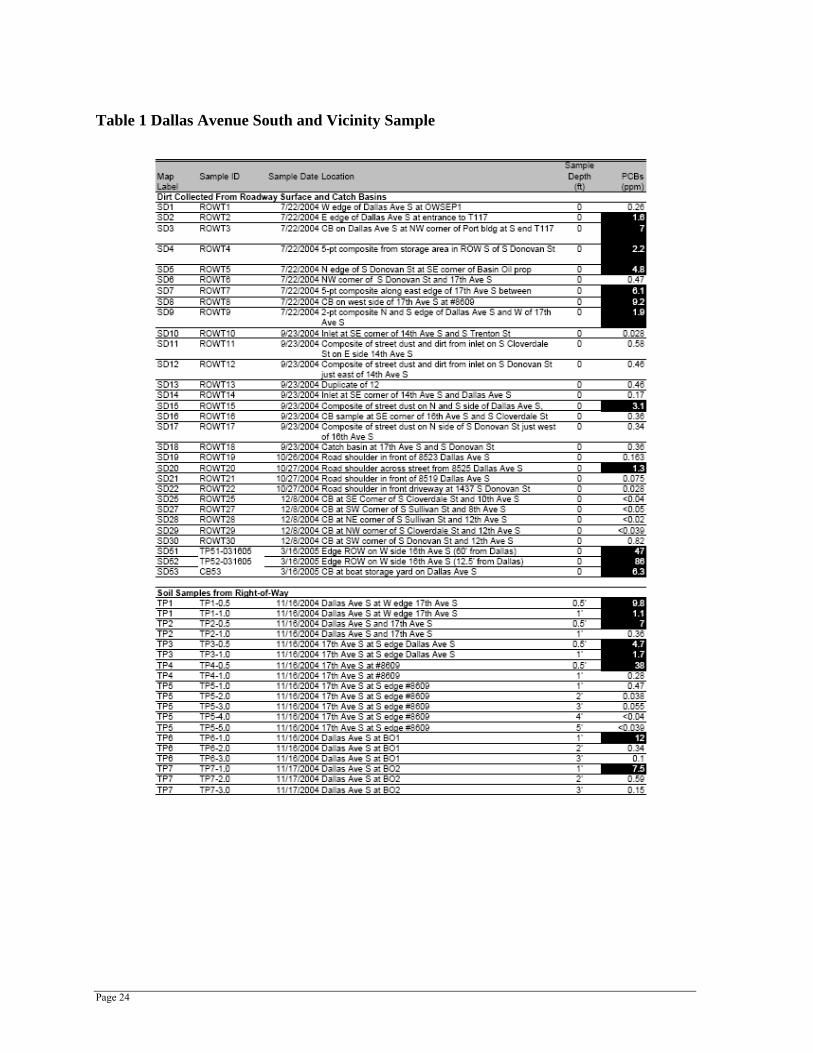
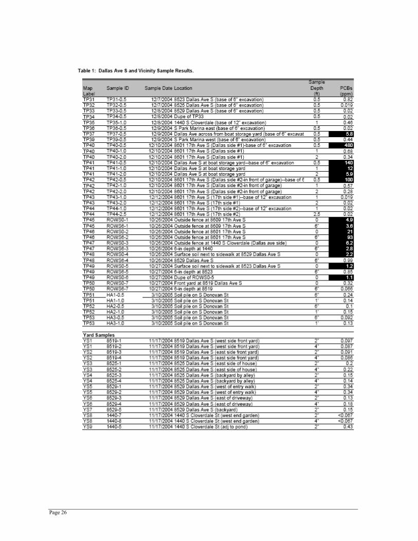
In August 2004, SPU discovered elevated concentrations of PCBs (Aroclor 1260) in catch basin sediment and street dirt samples collected from the roadways adjacent to Terminal 117. The initial sampling was performed as part of routine source sampling efforts to identify potential sources to the Terminal 117 EAA. Subsequent sampling narrowed the contaminated area to the section of Dallas Avenue South between 14th Avenue South and South Donovan Street, 17th Avenue South between Dallas Avenue South and South Donovan Street, and South Donovan Street between Dallas Avenue South and 17th Avenue South.
Sampling locations are shown in Figures 6 and 7 and results are summarized in Table 1 (follows this section). Concentrations in street dirt were as high as 9.2 mg/kg PCBs dry weight (DW) in a catch basin located on 17th Avenue South. Soil beneath the roadway contained as much as 66 mg/kg PCBs DW, and soil collected from the public right-of-way immediately adjacent to the

Page 20
roadway contained up to 93 mg/kg PCBs DW. The cleanup level in soil for unrestricted use under the state Model Toxics Control Act is 1 mg/kg PCBs DW.
The King County Health Department also collected soil samples in yards in the vicinity of the contaminated roadway areas. The highest PCB concentrations were found in soil samples collected from the front yards at 8601 (37–47 mg/kg) and 8609 (1.4–3.4 mg/kg) 17th Avenue South. All other samples were below the 1 mg/kg cleanup level.
At this time, a definitive source of the PCBs has not been identified. However, potential sources include past operations at the Malarkey Asphalt/Duwamish Manufacturing facility, Basin Oil, and road oiling for dust control by unknown parties.
South Park Marina
As noted previously, South Park Marina is primarily a small boat marina and do-it-yourself boat maintenance and repair facility. In the mid-1950s the property was the site of A & B Barrel Co., which reconditioned and repainted used barrels and drums. Liquid waste, including oils, grease, and sodium hydroxide, was discharged to a small pond and then to the Duwamish. The location of the pond and the manner in which it was abandoned has not been adequately documented.
Supplemental sampling of Terminal 117 in March 2004 detected PCBs at a concentration of 31 mg/kg in a soil boring next to the Terminal 117 and South Park Marina property line (Windward et al. 2005a). Additional sampling will need to be conducted to determine if PCBs are present in the soils west of the riverbank in that area of the marina property.
South Park Marina – Boat Storage
The South Park Marina boat storage property was sampled by SPU as part of the Dallas Avenue South investigation. Elevated levels of PCBs in the onsite catch basin (2.4 mg/kg Aroclor 1254 and 3.9 mg/kg Aroclor 1260) and soil (0.067 to 3.2 mg/kg Aroclor 1254/1260) were found at this facility. The PCBs may have run onto the property from Dallas Avenue South. The fact that almost all of the Dallas Avenue South samples contain Aroclor 1260 and this sample includes Aroclor 1254 suggests that there may have been another source. It is possible that it is from marine paints or hydraulic oils.

Page 21
Figure 6. PCB Soil Sampling Locations

Page 22
Figure 7. Dallas Avenue South and Vicinity PCB Soil Sampling Locations

Page 23
Boeing South Park
In November 1997, Boeing discovered the release of hydraulic fluid from an elevator in Building 15-01. Oil leaked into the elevator jack casing, a boring extending approximately 15 feet below the bottom of the elevator pit. Boeing estimated that approximately 50 gallons of oil had been released and initiated recovery actions by extracting oily water from the jack casing. Boeing found that the lower two-thirds of the jack chamber was uncased and bored through bedrock. Approximately 30 gallons of hydraulic fluid were recovered and Boeing continued to remove oily water from the jack casing. The hydraulic fluid was tested and did not contain PCBs (Boeing 1998).
Other Upland Contaminated Sites
Sites where there is evidence of a release of hazardous substances that may pose a threat to human health or the environment are entered into Ecology’s Confirmed or Suspected Contaminated Sites (CSCS) list. Generally these sites involve a release of chemicals from something other than an underground tank, such as a spill, material pile, waste storage, or other source. Releases from underground tanks are entered into Ecology’s Leaking Underground Storage Tank (LUST) list.
At present, Terminal 117 and Basin Oil are the only sites on the CSCS list within the area that drains to the Terminal 117 EAA. There are no LUST-listed tanks in the drainage area. South Park Marina will be investigated as a potentially contaminated site. The City of Seattle is continuing to work on a permanent cleanup of the PCB contaminated soils in the Dallas Avenue South vicinity and the two affected residential properties.
Page 24
Table 1 Dallas Avenue South and Vicinity Sample

Page 25
Page 26

Page 27

Page 28
Source Control Actions Specific to Terminal 117 This section describes the source control actions that are currently being taken, or that will be taken, to minimize recontamination of Terminal 117 sediments. Additional information, data collection, and monitoring plans are also discussed. Appendix A of this plan provides a list of source control actions, the responsible agency, and an estimated timetable for completion.
City of Seattle Actions
Basin Oil
In December 2004, the Seattle Department of Planning and Development issued a stop work order and Notice of Violation to Basin Oil for conducting site demolition activities without a permit. Demolition work involved removing tanks and associated equipment, as well as demolishing buildings, pavement, and other structures. Basin Oil must obtain a permit before continuing demolition operations. The City has worked with Basin Oil to improve erosion controls at the site during the demolition process. Basin Oil recently placed gravel in the disturbed areas at the south end of the property and installed a silt fence along the east side of the property to trap sediment in runoff that sheet flows off the site.
Dallas Avenue South Cleanup
In December 2004, SPU completed a source control action to reduce the exposure of nearby residents to the PCBs present in the public right-of-way adjacent to Terminal 117 and to control roadway runoff. Work included:
• Removing contaminated soil and placing clean gravel on roadway shoulders along Dallas Avenue South and 17th Avenue South. Approximately 6–12 inches of soil was removed and capped with gravel.
• Grading and paving South Donovan Street between Dallas Avenue South and 17th Avenue South, 17th Avenue South between South Donovan Street and Dallas Avenue South, and Dallas Avenue South between 17th Avenue South and South Donovan Street.
• Installing a temporary stormwater collection and treatment system to serve the newly paved roadways.
Initially, the stormwater system collected runoff from the public right-of-way and the adjacent Basin Oil property and routed it to a temporary treatment system located on the south side of South Donovan Street. The system was designed to handle runoff from a 10-year, 24-hour storm event. Runoff was treated by settling, as well as the use of sand, bag, and carbon filters prior to controlled discharge to the combined sewer on South Donovan Street at 17th Avenue South. Because the existing combined sewer is over capacity, the treated runoff is stored in five 18,000-gallon storage tanks to allow runoff to be released to the sewer at a controlled rate. SPU obtained a discharge authorization from King County Industrial Waste to allow discharge to the sewer. Effluent from the treatment plant was sampled and tested as required by the discharge authorization. PCBs were not detected (at 0.1 μg/L) in any of the samples.

Page 29
SPU also sampled and tested untreated runoff that entered the treatment plant. Results are summarized below:
Table 2 Dallas Avenue South Untreated Run-off
Sample Date PCB (μg/L) January 1, 2005 2.34 January 17, 2005 0.142 January 22, 2005 0.152 January 24, 2005 0.167 February 2, 2005 0.1U February 6, 2005 0.1U March 27, 2005 0.1U April 16, 2005 0.1U
U = Compound not detected at value shown
Because the PCB concentrations in the untreated runoff after the January 17, 2005, sampling were below the maximum concentration allowed by the discharge authorization (0.5 μg/L), King County allowed SPU to remove the treatment plant in late March. The storage tanks were left in place to allow runoff to be discharged at a controlled rate to the combined sewer. Under the revised discharge authorization, SPU collects monthly samples of runoff discharged to the combined sewer. PCBs have not been detected (at 0.1 μg/L) in the samples collected since the plant was removed.
To be prepared for possible emergency conditions (i.e., existing combined sewer capacity exceeded), SPU has received permission from the Port of Seattle to discharge runoff to the Port’s drainage system at the south end of Terminal 117. No emergency discharge has been required to date. As part of the agreement with the Port, SPU conducted the following work on Terminal 117 to prevent the treated runoff from becoming recontaminated prior to discharge to the Duwamish Waterway:
• Cleaned the existing catch basin at the south entrance to Terminal 117 (emergency discharge point for treated runoff) and the downstream catch basin adjacent to the waterway, and pressure-washed the existing 6-inch polyvinyl chloride (PVC) drain that crosses Terminal 117.
• Extended the existing 6-inch drain (noted above) located on the north side of the Terminal 117 south building to the end of the building, installed asphalt berms to direct flow to the downstream catch basin, and paved the planter area adjacent to the building.
SPU is currently working to develop a final cleanup plan for the public right-of-way. Cleanup will be completed by 2007 when the Terminal 117 EAA cleanup is scheduled to occur. Contaminated soil in the residential yards at 8601 and 8609 17th Avenue South was removed and the yards replanted in June 2005. SPU continues to sample soil in the right-of-way to delineate the project area for the final cleanup.

Page 30
Port of Seattle Actions The Port of Seattle has instituted measures to minimize the potential for contaminants entering the storm drainage system at Terminal 117. Additional improvements and maintenance activities are planned as part of the source control measures necessary to prevent recontamination of the adjacent Duwamish River sediment. In partnership with the City of Seattle and under agreement with EPA, the Port is also developing plans to conduct an EAA cleanup under CERCLA to address elevated PCB concentrations in adjacent sediment and bank areas of the river. This action will address potential source material detected in the intertidal shoreline and upland bank area through a combination of removal and placement of an isolating cap structure. The work will also remove or isolate historical asphalt waste materials deposited in the shoreline during the Malarkey plant era. The Port is preparing to have deed restrictions applied to the property as an institutional control measure to prevent erosion and control surface water runoff.
Terminal 117 Stormwater Protection
The 1999 CERCLA removal action included these measures to protect stormwater quality at Terminal 117:
• Interception of surface runoff into catch basins (Figure 5) designed to retain solids
• Paving of exposed soil areas to prevent erosion
• Installation of filter fabric and filter socks in catch basin inlets to retain sediment and periodic maintenance
• Inspection of tenant activities and outdoor storage practices to make sure materials are not a source of potential contaminants to stormwater runoff
In December 2004, the Port removed sediments from catch basins 5 and 6 as well as the connecting drain line. The Port will clean catch basin 5 and the contributing drainage network again, as necessary, until it is replaced with a structure better suited for retaining sediment and periodic cleaning. Prior to replacing the catch basin, all other (upgradient) catch basins on Terminal 117 and their connecting culverts (typically 4-inch PVC pipe) will be thoroughly cleaned. Inverted outlets to trap floatable materials will be installed in all catch basins that do not have them. Outfalls to the Duwamish River will be temporarily blocked during this work to ensure no materials are discharged to the river during the cleaning work.
Terminal 117 Early Action Area Removal
The Terminal 117 EAA removal is being conducted under an existing Administrative Order on Consent (Cohen 2003) signed by the City, King County, the Port, and The Boeing Company (Boeing)—working together as the LDWG—as well as EPA and Ecology. Work at the Terminal 117 EAA is sponsored by two of the four LDWG members: the Port and the City of Seattle.
The Terminal 117 EAA includes both the aquatic and shoreline portion of the site. In the time since the Terminal 117 EAA was identified, the Port and City have conducted a series of

Page 31
environmental investigations to further characterize environmental conditions in the near shore area and shoreline bank, identify a proposed removal boundary, and to identify potential sources of contamination.
The Port of Seattle/City of Seattle project team has identified PCBs as the primary risk driver for the Terminal 117 EAA (Windward 2003b; Windward et al. 2003). This finding was based on historical activities and data. After reviewing historical data in the vicinity of Terminal 117, field sampling was conducted to characterize the nature and extent of PCBs in the EAA in order to identify a proposed removal boundary, establish the general engineering characteristics of the shoreline sediment and bank soils, and identify potential sources of recontamination. Sampling was conducted from December 2003 to March 2004 and included surface and subsurface sediment sampling, soil borings along the upland shoreline bank, soil samples from the southern drainage ditch and catch basins, water sampling from intertidal seeps, and groundwater sampling from shoreline monitoring wells. A 24-hour tidal study to characterize the groundwater gradient beneath the near shore Terminal 117 upland area was also performed. The shoreline groundwater monitoring wells were checked at low tide for non-aqueous phase liquids (NAPL, a layer of pure product floating on groundwater). These results were summarized and interpreted in the Terminal 117 preliminary boundary technical memorandum (Windward et al. 2005b).
The Port and City are presently working with EPA to complete the engineering evaluation/cost analysis (EE/CA) for the removal action at Terminal 117 (Windward et al. 2005b). To date, the project team has concluded that source control measures are an important element to assuring long-term success of the removal action. The primary pathways of concern identified during the investigations include:
• Transport of contaminants from upland sources via stormwater runoff
• Erosion of contaminated soil from the unpaved shoreline banks into the Lower Duwamish Waterway
The following measures are being considered for the project (in addition to the standard source control practices routinely implemented by the Port) to ensure control of contaminants in stormwater runoff:
• All Terminal 117 pavement will be inspected to verify that it is in good condition and provides sufficient coverage to prevent erosion of underlying surface soil.
• Solids in the catch basins that discharge directly to the river will be sampled and analyzed for PCBs. These catch basins receive drainage from the remaining catch basins at Terminal 117. In order to protect sediments, PCBs must be at or below the SQS. If PCBs are detected above the SQS, additional investigations will be undertaken to identify and, where possible, eliminate or temporarily control them prior to implementing the selected early action alternative. In addition, catch basin 5 will be removed and replaced with a structure better suited for retaining sediment and periodic cleaning.
For contaminated soil in the unpaved shoreline banks, the EE/CA will include a detailed examination of several alternatives consisting of removal and capping. Additional information is currently being collected, including data on soil and groundwater and the EE/CA will be revised

Page 32
to incorporate the results of these investigations. When the EE/CA is completed, the report will present background information on the site, discuss available data and the proposed boundary of the removal action, document the development and evaluation of NTCRA alternatives, and discuss the rationale for the recommended removal action that will be implemented by the Port and the City, subject to EPA approval. The SCWG will continue to provide input to the Terminal 117 removal action process as it enters into the design/ implementation phase. The removal action is presently scheduled to begin in mid-2006.
Ecology Actions
Upland Contaminated Sites
Ecology will evaluate the properties listed below to determine if any of them have the potential to cause recontamination of the Terminal 117 sediment cleanup site. Properties determined to be a potential source of sediment recontamination will be addressed using Washington State Model Toxics Control Act (MTCA), the voluntary cleanup program, or other authorities as needed.
The schedule for source control actions is contained in Appendix A of this plan.
Factors included in any evaluation are:
• Proximity to the Lower Duwamish Waterway
• Presence of groundwater contamination
• A high potential to discharge directly to the waterway or infiltrate into stormwater systems
• Presence of chemicals that have the potential to accumulate in sediments
Where there is insufficient information to make a determination, Ecology will work with the property owner to obtain it. Ecology is evaluating the use of procedures for assessing the potential risk to sediments from contaminants in groundwater that have been used at other sites. Ecology will also use best professional judgment to determine which of these sites will require a determination on the potential for sediment recontamination.
Ecology’s initial focus will be on four properties:
• Port of Seattle Terminal 117: The Port of Seattle conducted additional work in June 2005 to characterize soil and groundwater in the proposed EAA, including additional shoreline soil borings, push probes, monitoring well construction, and sampling of the new and existing shoreline monitoring wells. This work is intended to address data gaps related to source control. Ecology will inspect the current tenants at Terminal 117 in coordination with the Port of Seattle to determine if they are potential sources of recontamination.

Page 33
• Basin Oil Company: The demolition and future assessment of the site will be monitored. The site has been added to Ecology’s list of confirmed and suspected contaminated sites. The soil and groundwater conditions at the site will need to be characterized for contamination. The condition of the septic system will also need to be investigated. A joint Ecology/EPA compliance inspection was completed on May 16, 2005.
• South Park Marina: The facility will be inspected for potential sources of recontamination, including compliance with the NPDES permit requirements, catch basin drainages and discharge locations, connections to the sanitary sewer, and the presence of any septic systems. The location of the A & B Barrel lagoon will be investigated as a historic source of contamination. Supplemental sampling of Terminal 117 in March 2004 detected PCBs at a concentration of 31 mg/kg in a soil boring next to the Terminal 117 and South Park Marina property line. Ecology will conduct sampling to determine if PCBs are present in soils in that area of the marina property.
• Boeing South Park: The drainage area for the northern portion of the facility that discharges to the storm drain south of the Terminal 117 sediment boundary will be inspected and any potential sources will be addressed. While the 15-01 building does not appear to drain toward the Terminal 117 cleanup area, Ecology will investigate the status of the elevator casing recovery operation.
Source Identification and Tracing Port of Seattle and SPU monitoring efforts have identified ongoing sources of the chemicals of concern present in the waterway sediments.
As part of its discharge authorization with King County, the SPU will continue to monitor PCB levels in stormwater runoff from the public right-of-way that is presently discharged to the combined sewer system. SPU will also collect additional soil samples to develop the final cleanup plan for the roadway areas.
SPU will be monitoring the stormwater collected during the interim action to address PCB contaminated soils. Additional sampling will be conducted to define the nature and extent of permanent remedies. The Port will test sediments collected in their storm drain catch basins to confirm that chemicals found in previous investigations are the result of historical activities and ensure the effectiveness of their source control program.
Post Cleanup Sediment Monitoring After completion of the Terminal 117 EAA, long-term sediment, seep and groundwater monitoring will be required to determine if the cleanup has achieved the goal of addressing PCB risks, and to determine if sediments are being recontaminated. If the results of long-term monitoring suggest that recontamination is occurring, immediate follow-up source control actions will be taken.

Page 34
Tracking and Reporting of Source Control Activities
Ecology is the lead for tracking, documenting, and reporting the status of source control to EPA. In turn, all source control activities will be documented by the appropriate agency performing the source control work. The agencies will provide reports to Ecology, who will provide waterway-wide and basin-specific reports.
The management of information and data is divided into two levels. The first level is documentation and tracking, where information is organized so that Ecology can track and manage source control activities at a given source or within a given basin(s). The second level is reporting to EPA. Please refer to the Lower Duwamish Source Control Strategy for further details (Ecology 2004).
Ecology will provide a Terminal 117 Source Control Completeness Determination to EPA for review and concurrence, when the source control plan for this area has been fully implemented, and when Ecology has determined that source control is successful. The determination will be developed in memo, letter, or report format as appropriate.

Page 35
References Atkins E. 1991. Personal communication (conversation record with Donald Lewis, General
Manager, Malarkey Asphalt, regarding contact with Malarkey Asphalt and corrections to the Site Hazard Assessment Report). Environmental Scientist, Washington Department of Ecology. August 22.
Basin Oil. 1995. Spill prevention control and countermeasure (SPCC) plan. Revised August 1996. Basin Oil Company, Inc., Seattle, WA.
Boeing. 1993. Termination of NPDES Permit No. WA-002987-4(I) for South Park. Letter from L.M. Babich, III to Pam Elardo, Department of Ecology. Boeing Commercial Airplane Group, Seattle, WA. November 8, 1993.
Boeing. 1998. MTCA release report. Building 15-01 Elevator, Boeing Commercial Airplane Group, 1420 South Trenton Street, Seattle, WA, WAD 980982672. Letter from L.M. Babich, III to Michael Gallagher, Department of Ecology. Boeing Commercial Airplane Group, Seattle, WA. February 10, 1998.
Cohen L. 2003. Personal communication (letter dated May 2 to Nancy Glaser, Wayne Grotheer, Steve Tochko, and Don Theiler regarding Malarkey Early Action Area). Manager, Cleanup Unit No. 3, Office of Environmental Cleanup, US Environmental Protection Agency Region 10, Seattle, WA.
Crow. 2004. Personal communication (telephone conversation) between Guy M. Crow, South Park Marina property owner, and Douglas Pearman, SAIC. June 24, 2004.
Ecology. 1987. Fact sheet – Application for National Pollutant Discharge Elimination System (NPDES) permit to discharge pollutants to state waters pursuant to the provisions of Chapter 90.48 Revised Code of Washington and the Federal Water Pollution Control Act as Amended. Applicant: Boeing Aerospace Company. December 23, 1987. Washington Department of Ecology, Redmond, WA.
Ecology. 1993. General NPDES permit coverage permit no. WAG-03004-5. February 5, 1993. Letter and permit from J. Glynn to Guy Crow, South Park Marina. Department of Ecology, Bellevue, WA.
Ecology. 2000. Dangerous Waste Compliance Inspection at Basin Oil Co., Inc. RCRA ID# WAD988477501 on 9/26/00. Letter from Robert Stone to Shelly Hood, Basin Oil Co. Department of Ecology, Bellevue, WA. November 14, 2000.
Ecology. 2002. Fact Sheet for Boatyard NPDES Permit (Draft). Washington State Department of Ecology, Bellevue, WA.
Ecology. 2004. Lower Duwamish Waterway Source Control Strategy. Washington Department of Ecology, Northwest Regional Office Toxics Cleanup Program. January 2004.

Page 36
Ecology. 2005. New Environmental Response Tracking System (NERTS) Version 1.3 041305. Washington State Department of Ecology, Bellevue, WA.
EMCON. 1996. Draft removal action work plan, Malarkey Asphalt site, Seattle, Washington. Prepared for Malarkey Asphalt Company. EMCON, Bothell, WA.
EMR. 2000. Interim report on compliance with issues identified in the compliance inspection on 9/26/00; Basin Oil Co. – RCRA ID# WAD988477501. Prepared for Basin Oil Co. EMR Incorporated, Redmond, WA.
EPA and Ecology. 2002. Lower Duwamish Waterway Site Memorandum of Understanding Between the United States Environmental Protection Agency and the Washington Department of Ecology. April 2002.
EPA and Ecology. 2004. Lower Duwamish Waterway Site Memorandum of Understanding Between the United States Environmental Protection Agency and the Washington Department of Ecology. April 2004.
Harper-Owes. 1983. Water quality assessment of the Duwamish estuary, Washington. Prepared for Municipality of Metropolitan Seattle. Harper-Owes Company, Seattle, WA. As cited in Windward 2003.
Hart Crowser. 1992. Site assessment UST decommissioning, Malarkey Asphalt Company. Prepared for Duwamish Properties, Inc., Hart Crowser, Seattle, WA.
Onsite. 1999. Malarkey Asphalt site – remedial action work plan. Prepared for the Port of Seattle. Onsite Enterprises, Inc., Redmond, WA.
Onsite. 2000. PCB removal/containment action, South Park site (formerly Malarkey Asphalt Company), Seattle, Washington. Prepared for the Port of Seattle. Onsite Enterprises, Inc., Redmond, WA.
SECOR. 1997. Focused site characterization report, Malarkey Asphalt Site, 8700 Dallas Avenue South, Seattle, Washington. Prepared for Copeland, Landye, Bennett and Wolf, LP, Port of Seattle and City of Seattle. SECOR International Incorporated, Bellevue, WA.
SECOR. 1998. Volume 1, final report, Malarkey Asphalt Site, 8700 Dallas Avenue South, Seattle, Washington. Prepared for Copeland, Landye, Bennett and Wolf, LP, Port of Seattle and City of Seattle. SECOR International Incorporated, Bellevue, WA.
Tanner, C.D. 1991. Potential intertidal habitat restoration sites in the Duwamish River Estuary. Environmental Protection Agency and Port of Seattle, Seattle, WA. As cited in Windward 2003.
URS. 1994. Site inspection report for the Malarkey Asphalt Company, Seattle, Washington. Prepared for the U.S. Environmental Protection Agency, Region 10. URS Consultants, Seattle, WA.

Page 37
Weston (Roy F. Weston, Inc). 1999. Site inspection report. Lower Duwamish River. RK 2.5-11.5. Volume 1 – Report and appendices. Prepared for U.S. Environmental Protection Agency, Region 10, and Seattle. As cited in Windward 2003.
Windward (Windward Environmental) 2003a. Phase 1 Remedial Investigation Report. Lower Duwamish Waterway Group. Prepared by Windward Environmental, LLC. July 2003.
Windward. 2003b. Task 5: Identification of Candidate Sites for Early Action. Technical Memorandum: Data Analysis and Candidate Site Identification. Final. Lower Duwamish Waterway Group. Prepared by Windward Environmental, LLC. June 12, 2003.
Windward et al. 2003. Lower Duwamish Waterway Superfund Site, Terminal 117 early action area. Task 1: Summary of existing information and data needs analysis. Prepared for the Port of Seattle. Windward Environmental LLC, Dalton, Olmstead & Fuglevand, Inc. and Onsite Enterprises, Inc., Seattle, WA. July 2003.
Windward, DOF, Onsite. 2004. T-117 sediment and soil supplemental data report. Draft. Prepared for the Port of Seattle. Windward Environmental LLC, Dalton, Olmstead & Fuglevand, Inc., and Onsite Enterprises, Inc., Seattle, WA.
Windward, DOF, Onsite. 2005a. Terminal 117 Sediment Soil, Water Field Sampling, Cruise and Data Report – Final. Prepared for the Port of Seattle. Windward Environmental LLC, Dalton, Olmstead & Fuglevand, Inc., and Onsite Enterprises, Inc., Seattle, WA. March 4, 2005.
Windward, DOF, Onsite. 2005b. Lower Duwamish Waterway Superfund site, Terminal 117 early action area. Terminal 117 Engineering Evaluation/Cost Analysis. Draft. Prepared for the Port of Seattle. Windward Environmental LLC, Dalton, Olmstead & Fuglevand, Inc., and Onsite Enterprises, Inc., Seattle, WA. March 4, 2005

Page 38

Page 39
Appendix A
Terminal 117 Early Action Sediment Cleanup – Source Control Actions

Page 40
Appendix A: Terminal 117 Early Action Sediment Cleanup – Source Control Actions
Task Name Responsible Agency Completion Date Comments
Dallas Ave S PCBs in street soils - Interim Action
City of Seattle Dec-04 (completed) Streets are paved, shoulders are excavated and re-graveled, and stormwater and catch basin sediments are being monitored.
Dallas Ave S PCBs in residential yards City of Seattle June-05 (completed) Contaminated soils at 8601 and 8609 17th Avenue South as removed and the yards restored.
Dallas Ave S PCBs in street soils - Cleanup Action
City of Seattle June-07 Contaminated soils will be removed, new storm drainage will be installed, and the roads will be restored. Permanent stormwater control will be implemented based on monitoring of Interim Action.
Inspect South Park Marina Ecology Dec-05
1) Review waste management practices, compliance with permit; 2) investigate sewer connections and discharge locations of storm drains and catch basins; 3) investigate location and fate of A & B Barrel waste lagoon; 4) sample soils adjacent to fence between Terminal 117 and South Park Marina due to contamination observed in borings at Terminal 117; 4) sample catch basins for metals and phthalates.
Basin Oil Ecology Dec-05 1) Monitor facility demolition; 2) refer for Site Hazard Assessment; 3) work with owner to ensure site is adequately characterized for soils and groundwater contamination, including on-site septic system..
Basin Oil Ecology May-05 (completed) Joint EPA/Ecology compliance inspection.
Inspect Boeing South Park Ecology Dec-05 1) Review drainage system and stormwater pollution prevention practices; 2) check status of hydraulic oil recovery; Look for other potential sources of sediment recontamination.
Terminal 117 Site Port of Seattle, Ecology June-06
1) Verify placement of institutional controls and write and adopt restrictive covenants that will prevent sediment recontamination by any future property owners in lieu of further characterization or cleanup action; 2) check soil cover/barrier across site for industrial use based on suspected residual contamination (sub-surface); 3) Continue discussions between the Port, the City, EPA and Ecology regarding the how to further assess the potential presence of subsurface contamination in the portions of the site formerly occupied by the Malarkey plant. Based on these discussions, complete any needed assessments in cooperation with EPA or Ecology; 4) inspect current tenants in coordination with the Port of Seattle to determine if they are potential sources of recontamination; 5) discuss condition and maintenance of on-site septic system with the Port..