m o n a g h a n
TRANSCRIPT
GF
GF
GF
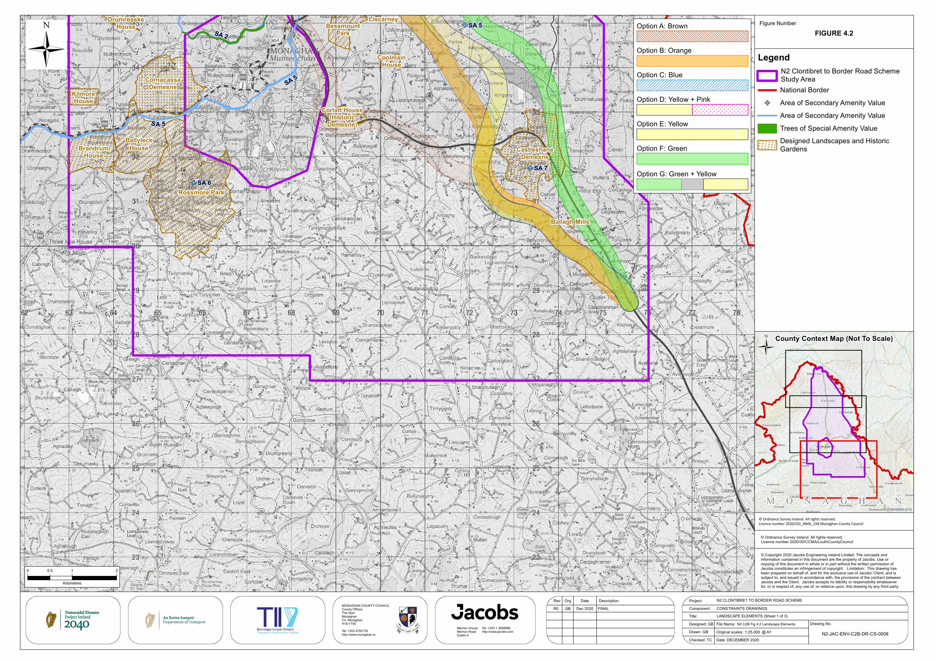
CastleshaneDemesne
Rossmore Park
BessmountPark
Liscarney
CoolmainHouse
DrumreaskeHouse
KilmoreHouse
BallyleckHouseBrandrum
House
Ballagh Mills
Corlatt House(Historic
Demesne)
CornacassaDemesne SA 5
SA 5
SA 2
SA 6SA 7
SA 5
ÜFigure Number
Project:Component:Title:
N2 CLONTIBRET TO BORDER ROAD SCHEME
Drawing No.
Rev Org Date Description
© Copyright 2020 Jacobs Engineering Ireland Limited. The concepts andinformation contained in this document are the property of Jacobs. Use orcopying of this document in whole or in part without the written permission ofJacobs constitutes an infringement of copyright. Limitation: This drawing hasbeen prepared on behalf of, and for the exclusive use of Jacobs' Client, and issubject to, and issued in accordance with, the provisions of the contract betweenJacobs and the Client. Jacobs accepts no liability or responsibility whatsoeverfor, or in respect of, any use of, or reliance upon, this drawing by any third party.
© Ordnance Survey Ireland. All rights reserved.Licence number 2020/30/CCMA/LouthCountyCouncil
File Name:Original scales: @ A1
GB Dec 2020
National BorderGF Area of Secondary Amenity Value
Area of Secondary Amenity ValueTrees of Special Amenity ValueDesigned Landscapes and HistoricGardens
LANDSCAPE ELEMENTS (Sheet 1 of 3)
M O N A G H A NOrdnance Survey Ireland 2018
Designed: GBDrawn: GB
CONSTRAINTS DRAWINGS
County Context Map (Not To Scale)
1:25,000
Ü
LegendN2 Clontibret to Border Road SchemeStudy Area
0 1 20.5
Kilometres
N2 C2B Fig 4.2 Landscape Elements
R0 FINAL
Date: DECEMBER 2020
FIGURE 4.2
N2-JAC-ENV-C2B-DR-CS-0008Checked: TC
Merrion House Tel: +353 1 2695666Merrion Road http://www.jacobs.comDublin 4
MONAGHAN COUNTY COUNCILCounty OfficesThe GlenMonaghanCo. MonaghanH18 YT50Tel: +353 4782739http://www.monaghan.ie
Option A: Brown
Option B: Orange
Option C: Blue
Option D: Yellow + Pink
Option E: Yellow
Option F: Green
E E E E E E E E E E E E E E E
E E E E E E E E E E E E E E E
E E E E E E E E E E E E E E E
E E E E E E E E E E E E E E E
E E E E E E E E E E E E E E E
E E E E E E E E E E E E E E E
E E E E E E E E E E E E E E E
E E E E E E E E E E E E E E E
Option G: Green + Yellow
© Ordnance Survey Ireland. All rights reserved.Licence number 2020/OSi_NMA_158 Monaghan County Council

GF
GF
GF
GF
GF
CastleshaneDemesne
Rossmore Park
BessmountPark
Liscarney
AnketellGroveHouse
Wallace'sCorn andFlax Mill
Tedavnet
Tuckmilltate/TyhollandSt Macartan's
College
CoolmainHouse
RaconnellHouse
DrumreaskeHouse
KilmoreHouse
BallyleckHouse
BrandrumHouse
DungillickHouse (Historic
Demesne)
Derrynashallog(Historic
Demesne)
FortJohnson
Pullis (possibledeserted
settlement)
Corlatt House(Historic
Demesne)
CornacassaDemesne
SA 5
SA 5
SA5
SA 5
SA 5
SA 2
SA 2
SA 2
SA 2
SA 2
SA 3
SA 3SA 3
SA 3
SA 3
SA 3
SA 3
SA 2
SA 2
SA 2
SA 2
SA 2
SA 2
SA 2
SA 2
SA 2
SA 1
SA 13
SA 2
SA 2
SA 5
EmyLough
ÜFigure Number
Project:Component:Title:
N2 CLONTIBRET TO BORDER ROAD SCHEME
Drawing No.
Rev Org Date Description
© Copyright 2020 Jacobs Engineering Ireland Limited. The concepts andinformation contained in this document are the property of Jacobs. Use orcopying of this document in whole or in part without the written permission ofJacobs constitutes an infringement of copyright. Limitation: This drawing hasbeen prepared on behalf of, and for the exclusive use of Jacobs' Client, and issubject to, and issued in accordance with, the provisions of the contract betweenJacobs and the Client. Jacobs accepts no liability or responsibility whatsoeverfor, or in respect of, any use of, or reliance upon, this drawing by any third party.
© Ordnance Survey Ireland. All rights reserved.Licence number 2020/30/CCMA/LouthCountyCouncil
File Name:Original scales: @ A1
GB Dec 2020
National BorderGF Area of Secondary Amenity Value
Area of Secondary Amenity ValueTrees of Special Amenity ValueAmenity Lake or RiverDesigned Landscapes and HistoricGardens
LANDSCAPE ELEMENTS (Sheet 2 of 3)
M O N A G H A NOrdnance Survey Ireland 2018
Designed: GBDrawn: GB
CONSTRAINTS DRAWINGS
County Context Map (Not To Scale)
1:25,000
Ü
LegendN2 Clontibret to Border Road SchemeStudy Area
0 1 20.5
Kilometres
N2 C2B Fig 4.2 Landscape Elements
R0 FINAL
Date: DECEMBER 2020
FIGURE 4.2
N2-JAC-ENV-C2B-DR-CS-0009Checked: TC
Merrion House Tel: +353 1 2695666Merrion Road http://www.jacobs.comDublin 4
MONAGHAN COUNTY COUNCILCounty OfficesThe GlenMonaghanCo. MonaghanH18 YT50Tel: +353 4782739http://www.monaghan.ie
Option A: Brown
Option B: Orange
Option C: Blue
Option D: Yellow + Pink
Option E: Yellow
Option F: Green
E E E E E E E E E E E E E E E
E E E E E E E E E E E E E E E
E E E E E E E E E E E E E E E
E E E E E E E E E E E E E E E
E E E E E E E E E E E E E E E
E E E E E E E E E E E E E E E
E E E E E E E E E E E E E E E
E E E E E E E E E E E E E E E
Option G: Green + Yellow
© Ordnance Survey Ireland. All rights reserved.Licence number 2020/OSi_NMA_158 Monaghan County Council

GF
GF
GF
FortSingleton
Ivy Hill
Glebe House, ErrigalTrough (Historic
Garden)
Spring Mount/MountAnketell (Historic
Gardens)
DungillickHouse (Historic
Demesne)
Lough Emy House(Historic
Demesne)
Derrynashallog(Historic
Demesne) Pullis (possibledeserted
settlement)SA
2
SA 3
SA 2
SA 2
SA 2
SA 2
SA 2
SA 2
SA 2
SA 2
SA 2
SA 3
SA 3
SA 3
SA 3
SA 3
SA 2
SA 2
SA 2
SA 2
SA 2
SA 1
SA 2
SA 3
EmyLough
ÜFigure Number
Project:Component:Title:
N2 CLONTIBRET TO BORDER ROAD SCHEME
Drawing No.
Rev Org Date Description
© Copyright 2020 Jacobs Engineering Ireland Limited. The concepts andinformation contained in this document are the property of Jacobs. Use orcopying of this document in whole or in part without the written permission ofJacobs constitutes an infringement of copyright. Limitation: This drawing hasbeen prepared on behalf of, and for the exclusive use of Jacobs' Client, and issubject to, and issued in accordance with, the provisions of the contract betweenJacobs and the Client. Jacobs accepts no liability or responsibility whatsoeverfor, or in respect of, any use of, or reliance upon, this drawing by any third party.
© Ordnance Survey Ireland. All rights reserved.Licence number 2020/30/CCMA/LouthCountyCouncil
File Name:Original scales: @ A1
GB Dec 2020
National BorderGF Area of Secondary Amenity Value
Area of Secondary Amenity ValueTrees of Special Amenity ValueAmenity Lake or RiverDesigned Landscapes and HistoricGardens
LANDSCAPE ELEMENTS (Sheet 3 of 3)
M O N A G H A NOrdnance Survey Ireland 2018
Designed: GBDrawn: GB
CONSTRAINTS DRAWINGS
County Context Map (Not To Scale)
1:25,000
Ü
LegendN2 Clontibret to Border Road SchemeStudy Area
0 1 20.5
Kilometres
N2 C2B Fig 4.2 Landscape Elements
R0 FINAL
Date: DECEMBER 2020
FIGURE 4.2
N2-JAC-ENV-C2B-DR-CS-0010Checked: TC
Merrion House Tel: +353 1 2695666Merrion Road http://www.jacobs.comDublin 4
MONAGHAN COUNTY COUNCILCounty OfficesThe GlenMonaghanCo. MonaghanH18 YT50Tel: +353 4782739http://www.monaghan.ie
Option A: Brown
Option B: Orange
Option C: Blue
Option D: Yellow + Pink
Option E: Yellow
Option F: Green
E E E E E E E E E E E E E E E
E E E E E E E E E E E E E E E
E E E E E E E E E E E E E E E
E E E E E E E E E E E E E E E
E E E E E E E E E E E E E E E
E E E E E E E E E E E E E E E
E E E E E E E E E E E E E E E
E E E E E E E E E E E E E E E
Option G: Green + Yellow
© Ordnance Survey Ireland. All rights reserved.Licence number 2020/OSi_NMA_158 Monaghan County Council