magadan oblast - urban sustainability research group
TRANSCRIPT

MA
GA
DA
N
258 � T H E R U S S I A N F A R E A S T
!
!
!
!
!
!
! P
Obo
Atk
a
Kul
u
Yam
sk
Tal
on
Upt
arS
okol
Kup
ka
Sta
rt
Deb
in
Duk
at
Mad
aun
Tal
aya
Mya
kit
Om
chak
Oro
tuk
Nel
koba
Mer
enga
Str
elka
Giz
higa
Gal
imyi
Nex
ikanMal
dyak
Oze
rnoe
Vet
reny
i
Gar
man
da
Bur
khal
a
Sei
mch
an
She
lting
a
Yab
lone
vy
Ady
gala
kh
Bur
kand
ya
Bal
agan
noe
Top
olyo
vka
Ust
-Tas
kan
Okt
yabr
ina
Bal
ygyc
han
Tak
htoy
amsk
Ver
khne
-Par
en
Mar
iny
Ras
kovo
i
Ver
khny
Sei
mch
an
Ola
Pal
atka
Yag
odno
e
Sin
egor
ie
Ust
-Om
chug
MA
GA
DA
N
Sus
uman
Arm
an
Elg
en
Kle
pka
Tau
isk
Tas
kan
Spo
rnoe
Shi
roky
Ste
koln
y
Kar
amke
nOro
tuka
n
Kho
lodn
y
Bel
icha
n
Om
sukc
han
Bol
shev
ik
Mya
undz
haK
adyk
chan
Sht
urm
ovoi
Kha
tyng
nakh
Ust
-Sre
dnek
anV
erkh
nyA
t-Y
urya
kh
OL
SK
Y
SR
ED
NE
KA
NS
KY
SE
VE
RO
-E
VE
NS
KY
OL
SK
Y
OM
SU
KC
HA
NS
KY
SU
SU
MA
NS
KY
TE
NK
IN
SK
YYA
GO
DN
INS
KY
KH
AS
YN
SK
Y
100
km
¯
KO
RY
AK
IA
SA
KH
A
By
New
ella
ndZ
hou
/S
ourc
es:
Min
istr
yof
Nat
ural
Res
ourc
es,
2002
;E
SR
I,20
02.
Map
7.1
Mag
adan
Obl
ast
460,
246
sq.k
m
Se
ao
fO
kh
o
tsk
Ru
ssia
nF
ar
Ea
st
Newell, J. 2004. The Russian Far East: A Reference Guide for Conservation and Development. McKinleyville, CA: Daniel & Daniel. 466 pages

MA
GA
DA
N
C H A P T E R 7
Magadan Oblast
Location
Magadan Oblast lies on the northwestern shores of the Sea of Okhotsk. The Chukotsky and Koryak Autonomous Okrugs border on the north; to the south is Khabarovsk Krai, and to the west lies the Republic of Sakha.
Size
460,246 sq. km, or about six percent of the Russian Federation. The total area of cities and villages is 62,700 ha, or less than 0.00014 percent of the oblast.
Climate
The arctic and subarctic climate is infl uenced by the Arctic Ocean to the north, the cold Sea of Okhotsk to the east, and the continental terrain of Sakha to the west. Winter lasts for eight months with temperatures as low as –70°c in Seimchan Gorge. Coastal tempera-tures are more moderate, with winter lows of about –47°c. Summer temperatures average about 15°c in Kolyma and about 8°c on the Okhotsk coast.
Geography and ecology
Magadan is covered mostly by permafrost and includes northern taiga and tundra wood-land ecosystems. The border between the two can be traced by the locations of stands of large tundra shrubs and the limits of riparian chosenia (Chosenia arbutifolia) and pop-lar (Populus) forests. Open tundra is limited to scattered areas in the mountains of the Kolyma region and along the Okhotsk coastline. The Kolyma plateau and the Chersky Mountain Range cover almost all the territory of Magadan. Most of the mountains do not exceed 1,500 m, with the highest rising to 2,586 m above sea level. Most of the water-sheds drain into the Arctic Ocean via the Kolyma and Omolon River basins. Large areas of tundra grow on the Taigonos Peninsula, at Pyagina, in the Taui lowlands, and on the coast of Shelting Bay. The defi ning factors of this area are widespread permafrost and lack of sheltered areas, which lead to low biological productivity and diversity. The main part of the region’s biomass and attendant biodiversity are concentrated along river valleys and on the coast. The region has limited forests, mainly Dahurian larch (Larix gmelini), which grow and regenerate slowly due to the extreme cold. The most productive forests grow around the city of Magadan and the gold mining regions of the Kolyma River basin. Many of the forests were logged in the 1970s and 1980s. The only remaining forests are in inaccessible areas or are in protected forest zones close to rivers, lakes, and the sea. Larch forests and marshland form the landscape in the south. Japanese stone pine (Pinus pumila) grows
259Newell, J. 2004. The Russian Far East: A Reference Guide for Conservation and Development. McKinleyville, CA: Daniel & Daniel. 466 pages
MA
GA
DA
N
260 � T H E R U S S I A N F A R E A S T
along the coast. The most valuable forests (mainly larch, poplar, and willow) grow along river valleys. The vegetation is 2 to 2.5 times denser in river valleys than on neighboring slopes, but plant productivity in the oblast as a whole is less than 18 percent of productivity in the riparian zones. These river valley forests are the richest in terms of species diversity, biomass, and productivity, and often have the main gold deposits.
Flora and fauna
The Yamskie Islands, off the Pyagina Peninsula on the southeastern coast, are home to over one million birds. Steller’s sea lions (Eumetopias jubatus) and Steller’s sea eagles (Haliaeetus pelagicus) also live on the islands. A population of Kamchatka marmot (Marmota kamts-chatica), a species virtually extinct in other parts of the region, has found a home in Magadansky Zapovednik. Large mammals include snow sheep (Ovis nivicola), brown bear (Ursus arctos), moose (Alces canadensis), and reindeer (Rangifer tarandus). The Okhotsk littoral contains the greatest biodiversity in Magadan. Rivers fl owing into the Sea of Okhotsk are the spawning grounds for many species of Pacifi c salmon (Oncorhyn-chus) and migrating char (Salvelinus). The interior rivers fl owing north into the Kolyma basin have rich stocks of Arctic grayling (Thymallus arcticus), whitefi sh (Core-gonus), lenok (Brachymastax lenok), and Northern pike (Esox esox).
Largest cities
Founded in 1933 as a way point for prisoners sent to the Kolyma gold fi elds, Magadan is the oblast’s largest city, with about 115,000 people. Two-thirds of all the oblast’s enterprises are registered in Magadan, which was recently declared a special economic zone and is exempt from various federal taxes. Susuman (pop. 16,800) is the administrative center for the Kolyma mining area.3
Population
As of January 1, 2001, the population was 227,200.4
Political status
Magadan City was established in 1933 as part of the “gulag archipelago” and was built by prison labor to serve as a port and processing facility for tin (initially) and gold mines in the area. In 1953, the oblast was formed from the northern area of Khabarovsk Krai and western Penzhinsky Raion in Koryakia. The Chukotka Autonomous Okrug was part of Magadan until 1991, when it successfully asserted separate administrative status. In the summer of 1999, the federal government approved Magadan City as a special economic
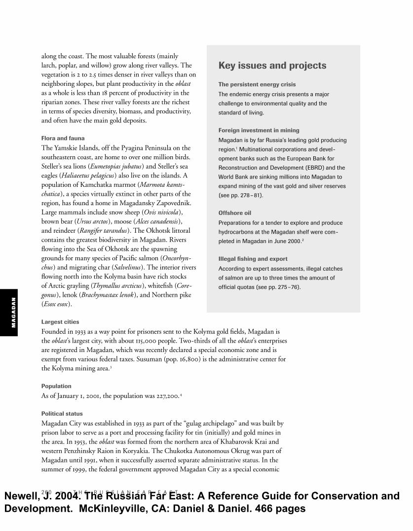
Key issues and projects
The persistent energy crisis
The endemic energy crisis presents a major
challenge to environmental quality and the
standard of living.
Foreign investment in mining
Magadan is by far Russia’s leading gold producing
region.1 Multinational corporations and devel-
opment banks such as the European Bank for
Reconstruction and Development (EBRD) and the
World Bank are sinking millions into Magadan to
expand mining of the vast gold and silver reserves
(see pp. 278–81).
Offshore oil
Preparations for a tender to explore and produce
hydrocarbons at the Magadan shelf were com-
pleted in Magadan in June 2000.2
Illegal fi shing and export
According to expert assessments, illegal catches
of salmon are up to three times the amount of
offi cial quotas (see pp. 275–76).
Newell, J. 2004. The Russian Far East: A Reference Guide for Conservation and Development. McKinleyville, CA: Daniel & Daniel. 466 pages

MA
GA
DA
N
M a g a d a n O b l a s t � 261
zone. “The zone has brought in an additional 11 million rubles (u.s.$400,000) in registration fees as companies enter the market ... [and] twenty-seven trading companies have signed contracts to do busi-ness in Magadan.” 5 The law, which will be in effect for the next fi fteen years, aims to stimulate develop-ment of natural resources and manufacturing by reducing federal taxes and customs duties.
Natural resources
The greatest economic resource of the oblast is pre-cious metals, most of which are undeveloped. The Magadan administration plans to tender several appraised and unappraised gold lodes (including Shkolnoe, Lunnoe, Natalka, and Vetrennoe) with estimated reserves of 900 tons.6 Marine resources are the second most important. Habitat destruction and overfi shing are reducing salmon stocks, particularly in the Arman, Ola, and Taui Rivers. Stocks of spe-cies such as pollock in the Sea of Okhotsk have been declining precipitously since 1990. Seismic tests done in the 1970s confi rmed that the shelf has oil and may contain up to 4.5 million tons of oil. Gas resources are estimated at 1,170 billion cu. m.
Main industries
Gold and silver mining dominates the economy, amounting to more than 70 percent of total output, and other leading sectors are oriented to supporting the needs of the mining industry (see fi g. 7.1). Gold production totaled about 30 tons in 2000, a large increase from 1995 when the total was 22.34 tons (see fi g. 7.2). Of this total about 17 tons come from ore deposits and the remainder from placers.7 Mines are located in Susumansky, Yagodninsky, and Tenkinsky Raions, and parts of Omsukchansky, Srednekansky, and Khasynsky Raions. In June 1998, the Kolyma Gold Refi nery was completed; it is the seventh-largest gold refi nery plant in Russia and has an annual capacity of 30 tons.8 Magadan has a small fi shing fl eet (pollock, herring, and salmon) that focuses on the Sea of Okhotsk and has some limited seafood processing facilities. The total reported fi sh catch for 1999 was 66,700 tons, about half of which was processed.
Figure 7.1Industrial production in Magadan Oblast, 1999
Source: Goskomstat, 2000.
Nonferrousmetallurgy
72% Other2%
Machinery2%
Foodproduction
6%
Electricalenergy
18%
Figure 7.2Gold production in Magadan Oblast, 1993–2000
1993 1994 1995 1996 1997 1998 1999 2000
Source: Gorny Zhurnal, 2001.
Metric tons
0
5
10
15
20
25
30
35
Newell, J. 2004. The Russian Far East: A Reference Guide for Conservation and Development. McKinleyville, CA: Daniel & Daniel. 466 pages

MA
GA
DA
N
262 � T H E R U S S I A N F A R E A S T
Infrastructure
Relatively isolated geographically, Magadan relies heavily on air transportation. Of the seven local aviation companies operating in Magadan City, the largest is Mavial, which serves almost half of all passengers fl ying in and out of Magadan. Because of higher fuel and other costs, airline tickets are more expensive than they are in other parts of Rus-sia. Almost all airport facilities and services are in need of repair or renovation. Direct air service is available to Moscow, St. Petersburg, Khabarovsk, Vladivostok, and other Russian cities, and there are even biweekly fl ights to Anchorage, Alaska. Each of the raion centers has an airstrip, as have most small villages, which are served by an aging fl eet of an-2 biplanes (built in the 1960s) and an-28 twin-prop planes. Remote mines such as Kubaka rely on helicopter transport in the summer. Magadan is poorly integrated with the rest of the rfe. For example, the main highway to the Republic of Sakha is in poor condi-tion, even by Russian standards, and since 1998, there have been no direct fl ights from Magadan to Kamchatka. The Magadan seaport, with an annual capacity to serve 3.5 million tons of cargo, was opened to foreign vessels in 1995. The port serves Magadan as well as the Chukotka Au-tonomous Okrug and Sakha, to which cargo is hauled by truck along a 1,500 -km high-way. The port is ice-free from May till December and remains open year-round with the help of icebreakers. The cargoes it handles, mostly from ships operated by companies in the rfe, mainly consist of coal, ore concentrates, 20 -foot containers, and food products. South Korea and U.S. vessels have recently introduced regular service. The port plans to close underused facilities, leaving only two operating docks. Port equipment is outdated; most of the cranes were built in the 1970s. Because of the extensive mining industry, Magadan has a much more developed road system than neighboring territories. Few of these highways are paved, however, and many are nearly impassable during the spring melt. Only winter roads and air transport serve the most remote areas (e.g., Severo-Evensky Raion). Internet access is limited to the city of Magadan. Most towns have tele-phone service, but the most remote villages (e.g., Verkhne-Paren) rely on two-way radio contact with nearby towns for emergencies and news of incoming fl ights.
Foreign trade
The greatest exports in terms of volume and value are gold and silver. Nearly everything else is imported: food, clothing, vehicles, building materials, and fuel. Used cars are imported from Japan. Food is imported primarily from other areas of Russia and the former Soviet Union, but South Korea, Canada, and the United States are also major food exporters The dilapidated Kolyma Highway is the only overland route between Magadan and the rest
of Russia.
Vla
dim
ir D
inet
s
Newell, J. 2004. The Russian Far East: A Reference Guide for Conservation and Development. McKinleyville, CA: Daniel & Daniel. 466 pages

MA
GA
DA
N
M a g a d a n O b l a s t � 263
to Magadan. In 2000, Magadan ranked fi rst among destina-tions for U.S. exports (valued at u.s.$35,710,000) to the rfe. U.S. companies exported mainly food products (supplying 60 percent of the local food market), fuel (avia-tion fuel, coal, and diesel), and mining and construction equip-ment. Clothing and other dry goods (typically of the lowest qual-ity) most often come from China and South Korea. Prices in villages are double or triple what they are in the city of Magadan. In 1999, eight enterprises were involved in
exporting fi sh, and 17,000 tons of seafood products (54 percent more than in 1998) were exported abroad, totaling u.s.$20 million, mainly to Japan (57 percent) and the United States (42 percent), with only 1 percent being sent to South Korea.
Economic importance in the RFE
Through its incredible mineral wealth and established mining industry, Magadan attracts millions of dollars of foreign investment every year. Magadan’s gold mining industry is the largest in the Russian Federation and now accounts for about 25 percent of Russia’s total production.
General outlook
The basis of Magadan’s economy is mining precious metals. Many explored deposits remain to be exploited, and new discoveries will undoubtedly establish further mineral reserves. With this in mind, environmental organizations such as the Magadan Center for the Environment (mace) focus on regulating practices and enforcing environmental quality standards. Foreign investors, backed by loans from the International Finance Corporation (ifc), the European Bank for Reconstruction and Development (ebrd), and the U.S. political risk insurance agency—the Overseas Private Investment Corpora-tion (opic)—have effectively taken over control of the majority of gold production by the industry; more than half of all the annual gold yield is from projects operating with foreign capital. Tensions between Russian and foreign partners and Russian government agencies, however, complicate some of the development projects; see the Dukat silver project, pp. 280 – 81. The entire Kolyma River basin, the center of the mining industry, has been hit hard by poorly planned and executed mining. Some of the last remaining river valleys in the upper Kolyma River basin may be opened up to gold extraction. Given the low price of gold and complicated investment conditions, development of these reserves is still limited to the richest deposits, but this will change as reports of steady profi ts from the huge Kubaka gold project are leading to investment in other projects. Foreign investors and international fi nancial institutions maintain that their participation is actually reducing environmental
The city of Magadan, typical Soviet construction.
Newell, J. 2004. The Russian Far East: A Reference Guide for Conservation and Development. McKinleyville, CA: Daniel & Daniel. 466 pages

MA
GA
DA
N
264 � T H E R U S S I A N F A R E A S T
impact by bringing in more ecologically benign technologies and equipment. Critics, however, counter that the Kubaka mine, which was touted as a model mine that would help green the industry, has a poorly designed tailings dam and that the mine operations in general are not “consistent with good international mining practices.” The great wealth produced by the industry has, unfortunately, benefi ted only a small percentage of the region’s population. In January 2000, a report in Vremya (Interfax) rated Magadan as one of the ten worst places to live (ranked seventh worst) in the Russian Federation.9 Like most regions in the rfe, Magadan has been unable to develop a stable and en-vironmentally clean energy supply. Low-grade coal and diesel for heating and electricity contribute more pollution, and local people are cutting more trees, as fi rewood increas-ingly becomes the main source of home heating in many villages. River valleys can be used to develop small-scale wind and hydroelectric energy projects, reducing energy costs of mining ventures and releasing funds for ecological measures. Estuarine portions of every salmon run in the Taui and Gizhiga Bays have one or more illegal fi shing operations. Joint fi shing ventures registered as scientifi c research are involved in overfi shing and illegal fi sh exports to Japan, which imports most of Magadan’s fi sh exports. Over 75 percent of the region’s forests have been logged since the fi rst major settle-ments were built in the early 1930s. Heavy logging along river valleys, particularly in the northern regions, has caused serious soil erosion, divided riverbeds, and destroyed salmon-spawning grounds. Often in the summer, following clear-cut logging, the permafrost melts, causing entire layers of soil to slip from the hillsides. This clogs rivers and causes fl ooding in river basins. In winter, these fl ooded areas become vast ice fi elds, destroying the most important wintering grounds for moose, ermine (Mustela erminea), ptarmigans (Lagopus), and hazel grouse (Bonasa bonasia). Oil exploration and extraction might be the greatest future threat to ecosystems in the Sea of Okhotsk. Most specialists believe, however, that oil exploitation will not happen soon as investors will wait to see if the Sakhalin oil projects are successful. Opposition from the Pacifi c Institute of Fisheries and Oceanography (tinro), Magadansky Zapoved-nik offi cials, and, in particular, mace has held back the developments. In 1999, the Min-istry of Natural Resources suspended the license of Trest Dalmorneftegeofi zika [Trust Far East-Sea-Oil-Geophysics], a Sakhalin-based company, to conduct offshore seismic testing for oil in the Sea of Okhotsk by Magadan. mace charged that Trest Dalmorneftegeofi zika failed to conduct an environmental impact assessment before it began the testing. tinro’s economic calculations, meanwhile, emphasize that oil extraction would be less profi t-able than exploiting marine fi sh resources. Other offi cials, however, remain dedicated to developing offshore oil reserves.10 In November 2000, the Ministry of Natural Resources approved the Magadan offshore oil and gas lease program, making it a federal program. Magadan’s ecology suffers because the population of the region is transient. The econo-my was built by the Stalinist gulag system of prison labor. In the 1970s and 1980s, workers from European Russia came to work for several years for high wages and then returned home. Historically, many residents have not been tied to the land and, therefore, few have taken care of it.
— Alexander King, Josh Newell, Mikhail Krechmar
Newell, J. 2004. The Russian Far East: A Reference Guide for Conservation and Development. McKinleyville, CA: Daniel & Daniel. 466 pages

MA
GA
DA
N
M a g a d a n O b l a s t � 265
EcologyMikhail Krechmar
The mountainous terrain consists largely of a system of small ridges and highlands. The arctic and subarctic climate is infl uenced by the northern Arctic Ocean to the north, the cold Sea of Okhotsk to the east, and the continental terrain of Sakha to the west. The most severe climates are in the internal regions of the Kolyma basin, where the conditions are extremely continental. The frozen period occupies eight months of the year, and temperatures of –70°c have been recorded at the Seimchan Gorge. Coastal temperatures are much more moderate, with winter temperatures staying above –47°c. Average summer temperatures in continental Kolyma are between 12° and 18°c, and between 6° and 10°c on the Okhotsk coast. Magadan contains northern taiga and tundra woodland ecosystems. The border between the two can be traced by the locations of stands of large tundra shrubs and the limits of distribution of strips of intrazonal chosenia and poplar for-ests. Open tundra is limited to scattered areas in the moun-tains of the Kolyma region and in strips of southern tundra along the Okhotsk coastline. There are signifi cant areas of tundra on the Taigonos Peninsula, at Pyagina, in the Taui lowlands, and on the coast of Shelting Bay. Dahurian larch is a dominant forest species. Intrazonal riparian poplar and chosenia forests penetrate deep into the shrub and mountain tundra, and reach their greatest develop-ment in the northern taiga zone. Aromatic poplar (Populus suavolens) and chosenia are the canopy species here with an understory of various shrubs, providing thick ground cover in local riparian formations. Formations known as redkolesie, or sparse forest, occupy much of the rfe. Larch redkolesie occupies a signifi cant por-tion of the forested area of Magadan. There are relatively few species here, and bioproductivity is low. Plant productivity here is less than 18 percent of that in the riparian zones. Changes in altitude are analogous to changes in latitude. Lower elevations are forested with Dahurian larch redkolesie, except on the coast, where occasional stands of stone birch (Betula ermanii) exist. The second belt consists of shrub birches, Japanese stone pine, and dwarf alders (Alnus). Above this there is mountainous tundra with mosses and lichens and patches of goltsi uplands. The main plant communities within the direct climatic infl uence of the coast are thickets of Japanese stone pine on slopes, with stone birch below them. A fairly rich understory is populated with shrubs above a grassy ground cover. The steep coastline rises directly to small (up to 600 m) moun-tains adjacent to the sea. Long stretches of rocky outcrops and cliffs dominate much of this landscape. These ravines alternate with depressions covered with meadow vegetation, which serve as a food base for large numbers of snow sheep
and brown bear. The depressions are encircled at the upper levels by stone birch, and a belt of Japanese stone pine above that. The Okhotsk littoral contains the greatest biodiversity in Magadan. Tides vary between 2 and 6.5 m, while the width of the littoral reaches between 2 and 4 km in some bays. Riv-ers fl owing into the Sea of Okhotsk are the spawning grounds for many species of Pacifi c salmon: pink (Oncorhynchus gorbuscha), chum (O. keta), coho (O. kisutch), and chinook (O. tschawytscha). They are also the home for migrating river char: Dolly Varden (Salvelinus malma) and East Siberian char (S. leucomaenis). The interior rivers of Magadan fl ow north into the Kolyma basin, and have fi sheries of little commercial value. They are, however, critically important to local subsistence activities. The main species are Arctic grayling, whitefi sh, lenok, and northern pike. The defi ning factors of this area are widespread permafrost and a lack of sheltered areas, which lead to low biological productivity and diversity. Group I forests are almost completely absent. The main part of the biomass of the region and attendant biodiversity are concen-trated along river valleys and on the coast.
Protected area system Most of the protected areas in Magadan were established between 1968 and 1991. In addition to the zapovednik and zakazniks listed below, there are thirty regional natural monuments, and one federal natural monument, Ostrov (Island) Talan. mace and the Institute of Biological Problems of the North (ibpn) identifi ed areas that need to be protected. But fi nancial diffi culties associated with economic decline have led to a lack of funding for existing protected areas, let alone proposed ones. For example, many of the reserves do not have the fi nancial resources to fi ght forest fi res, even those occur-ring within their own borders.
Zapovedniks. The only federal-level protected territory in the oblast is Magadansky Zapovednik. Magadansky. Established in 1982 in the Olsky and Srednekansky Raions, the zapovednik totals 883,817 ha, the third largest in the rfe. Magadansky Zapovednik consists of four separate sections: Kava-Chelomdzhinsky, Olsky, Yamsky, and Seimchan. The reserve’s biological richness is closely linked to the Sea of Okhotsk, one of the cleanest and most biologically productive seas in the world. The Magadan Ministry of Natural Resources oversees the administration of the zapovednik from its offi ces in the city of Magadan, cen-trally located to all of the protected territories. The ministry provides some funds to the zapovednik but these are far from suffi cient. Located in the southwest near the border of Khabarovsk Krai, between the slow fl owing Kava River and the rushing,
Newell, J. 2004. The Russian Far East: A Reference Guide for Conservation and Development. McKinleyville, CA: Daniel & Daniel. 466 pages

MA
GA
DA
N
266 � T H E R U S S I A N F A R E A S T
The zapovednik includes fl ora communities typical of the southern Magadan: 638 species of vascular plant grow in the Olsky, Yamsky, and Kava-Chelomdzhinsky sec-tions; the species-poor Seimchan section has only 236 types of plant. Dahurian larch, the most common forest species, covers 62 percent of the zapovednik ’s total area. Japanese stone pine occupies 34 percent. Ayan spruce (Picea ajanensis), a relict species, grows in the Yamsky region. Eighty-three species of rare vascular plant grow in the zapovednik. Two rare plant species, Ola magadania (Magadania olaensis) and Asian quillwort (Isoetes asiatica), occur in the area. There are also two species of amphibian: Siberian sala-mander (Salamandrella keyserlingii) and Siberian frog (Rana amurensis). Thirty-two species of fi sh inhabit the lakes and rivers. The most numerous
anadromous fi sh are chum, coho, and pink salmon. Chinook and sockeye salmon are spotted occasionally. Dolly Varden, Arctic grayling, and East Siberian char can be found in large rivers (Chelomdzha, Yama, and Kava). The salmon spawning grounds in the Chelomdzha and Yama Rivers are the largest natural ones remaining on the Okhotsk shore. One hundred seventy-three bird species, including 150 nesting species, can be found in the zapovednik. Marine bird colonies deserve special attention, there being forty-eight mixed and single-species colonies living among the cliffs along the Okhotsk seashore in the Olsky section. The pri-mary species are black-legged kittiwakes (Larus tridactylus) and slaty-backed gulls (L. schistisagus). Nesting birds include pelagic cormorant (Phalacrocorax pelagicus), black guillemot (Cepphus carbo), and horned puffi n (Fratercula cornuta). Three large colonies of tufted puffi n (F. cirrhata) are located here as well. Marine bird colonies on the Yamskie Islands are the largest in northern Pacifi c. They include common and thick-billed murres (Uria aale, U. lomvia), crested, parakeet, and least auklets (Aethya cristatella, A. psittacula, A. pusilla), black guillemot, tufted and horned puffi ns, slaty-backed gull, black-legged kittiwake, pelagic cormorant, and North-ern fulmar (Fulmarus glacialis). According to bird counts on Matykil, the largest island of the archipelago, there are about 7 million birds. Most numerous are least auklets. Rare species nesting in the zapovednik include osprey (Pandion haliaetus), Blackiston’s fi sh-owl (Ketupa blakistoni), peregrine falcon (Falco peregrinus), and Steller’s sea eagle (forty-eight pairs). Golden eagle, white-tailed sea eagle, and long-billed murrelet (Brachyramphus perdix) are occasionally spotted in
mountainous Chelomdzha River, the Kava-Chelomdzhinsky section (624,456 ha) protects the typical boreal and fl ood-plain ecosystems of both plains and mountains and, thus, the nesting and migration stops for waterbirds and spawning grounds. The inland territories have large expanses of larch-dominated taiga (larch covers 52 percent of the zapovednik territory), and riparian poplar and willow forests. Alpine tundra plants grow on mountain ridges. Occupying the western half of Koni Peninsula, the area included in the Olsky section (103,425 ha) is mountainous with an average altitude of 1,000 m, and has picturesque cliffs and valleys. The nearby Sea of Okhotsk greatly affects the climate. Protected elements include coastal ecosystems, populations of brown bear, snow sheep, Kamchatka marmot (a species once nearly extinct in the region), and Steller’s sea eagle. Situated in the north, the Seimchan section (117,839 ha) protects the fl oodplains and ecosystems of the Kolyma River valleys. Upstream lies the Kolymskaya Hydroelectric Station, which regulates the river’s fl ows. The climate is continental. Situated in the southwest, the Yamsky section (38,096 ha) consists of three unconnected parts. The largest lies 25 km upstream from Yamsk Village on the fl oodplains of the Yama River, which have relict stands of east Siberian fi r (Abies nephrolepis). The second section includes the coast of the Pyagina Peninsula from Cape Yapon to Cape Chyorny, an area of 51 sq. km. The third includes the Yamskie Islands, 20 km offshore of Pyagina Peninsula, which are home to the rfe’s largest seabird colony. The islands are also home to Russia’s largest colony of Steller’s sea lions and large numbers of Steller’s sea eagles.
The Pacifi c eider (Somateria molissima var. nigrum) is the most abundant of four RFE eiders. Its numbers have decreased dramatically in recent decades, but it is still widely hunted, primarily for its down, used to make clothing.
Vla
dim
ir D
inet
s
Newell, J. 2004. The Russian Far East: A Reference Guide for Conservation and Development. McKinleyville, CA: Daniel & Daniel. 466 pages

MA
GA
DA
N
M a g a d a n O b l a s t � 267
this region. Yellow-billed loon (Gavia adamsii) and Bewick’s swan (Cygnus bewickii) migrate from the Kava-Chelomdzha forestry region. Brant geese reportedly nest near the Koni Peninsula shoreline in the spring. Forty species of mammals live in the zapovednik, includ-ing Microtus voles, Siberian chipmunk (Tamias sibiricus), northern pika (Ochotona hyperborea), variable hare (Lepus timidus), brown bear, red fox, sable, ermine, American mink (Mustela vison), and moose. Common but less abundant species are Eurasian squirrel (Sciurus vulgaris), fl ying squirrel (Pteromys volans), Clethrionomys voles, Siberian weasel (Mus-tela sibirica), and wolverine (Gulo gulo). Eurasian lynx (Felis lynx) is spotted in all parts of the zapovednik. The shorelines of the Olsky and Yamsky sections are the only places where Kamchatkan marmot is found. Other rare species include Amur lemming (Lemmus amurensis), muskrat (Ondatra zibethica), and wild reindeer. Three species of seals (bearded [Erignathus barbatus], spotted [Phoca largha], and ringed [Ph. hispida]), Steller’s sea lion, and three species of whales (killer whale [Orcinus orca], beluga whale [Delphinapterus leucas], and gray whale [Eschrichtus robustus]) are found in the marine part of the zapovednik, that is, the seashore of Koni Peninsula and Pyagina and Yamskie Islands. Harbor porpoise (Phocaena phocaena), Dall porpoise (Phocaenoides dalli), and ribbon seal (Phoca fasciata) are also occasionally found in these waters.
Zakazniks. The Magadan Hunting Service manages the eleven zakazniks, all of which have oblast -level status. Kavinsky Valley (320,000 ha). There is a description of this zakaznik on pp. 269 –70. Malkachansky Tundra (45,000 ha). Created in 1967 to pro-tect ecosystems and migratory waterfowl, this zakaznik does allow hunting for pelts. In 1993, regional authorities extended the life of this zakaznik until 2003. The prevailing landscapes are windswept tundra and valleys with larch. Due to absence of staff, each fall and spring, people hunt the wildlife. Odyan (72,700 ha). There is a description of this zakaznik on pp. 269 –70. Atkinsky (123,000 ha). Established in 1982 to protect bighorn sheep populations, this zakaznik had protected status until 2002. Prevailing landscapes are treeless mountains with many cliffs and cirques. Solnechny (3,700 ha). Created in 1975 to protect migratory waterfowl, the area, characterized by mountainous taiga and Japanese stone pine, is patrolled by only one ranger. Khinike (370,000 ha). Created in 1986 to protect a variety of animals, this zakaznik of mountains and valleys has pro-tected-area status until 2021. Located far enough from trans-port routes, the region remains free from hunters because there is no access. There are no rangers patrolling the area. Taigonos (350,000 ha; initially 400,000 ha). This zaka-znik of mountainous tundra and coastal bluffs was created in 1973 to protect snow sheep. Its status will be discussed again
in 2004. Two rangers patrol the area. In 1995, the size of the zakaznik was reduced by 50,000 ha to give more land to in-digenous peoples living in the nearby village of Topolyovka. Burgali (104,500 ha). Created to increase game animal populations, this zakaznik was established for a ten-year pe-riod in 1993. The highlight of the area is the colorful Burgali River valley, which is rich in fl ora and fauna, and has large fl oodplains and mountainous larch taiga. There are no staff. Omolonsky (159,700 ha). This zakaznik was created in 1980 to protect moose and sable. The prevailing landscapes are lowlands with some wetlands and fragments of mountain-ous taiga including thin larch forests and Japanese stone pine. One ranger patrols the area. One-third of the zakaznik lies in neighboring Chukotka. Kubaka (280,000 ha). Created in 1994 for a period of ten years, this zakaznik protects game animals and is located between the Gizhiga and Khivach Rivers, about 80 km north of the village of Evensk. Mountain and valley ecosystems with fauna and fl ora typical of Magadan defi ne the area. Two rangers patrol the area. Sugoi (152,700 ha). Created in 1995 for a ten-year period, the zakaznik protects sable, river otter (Lutra lutra), and American mink. The most biologically productive portion is the Kolyma basin, which has a rich diversity of fl ora and fauna. One ranger is employed here.
Natural monuments. Talan Island Federal Natural Monu-ment (32 ha) in the Taui Bay is an island with a huge seabird colony. There is no administration or staff.
Biodiversity hotspots
1. Magadansky Zapovednik (wetland, forest, and marine)See pp. 265– 67 for a description of the reserve.
Threats. The hydrological regimes of the Seimchan section located near the Kolymskaya and Ust-Srednekanskaya hydropower plants (the latter still under construction) have been completely altered; scientists predict that within fi fty to eighty years the forest vegetation will be completely changed. Barren permafrost areas will increase and the succession in natural communities will change. Another threat is the newly constructed fi sh farms, which have almost completely wiped out natural salmon stocks in the large rivers. Some companies are lobbying to construct hatcheries near the zapovednik ’s spawning grounds. Mining has virtually destroyed fi sh popu-lations in the Kolyma region. Other threats include the pro-posed development of a coal fi eld on the Burgagylkan River,
Newell, J. 2004. The Russian Far East: A Reference Guide for Conservation and Development. McKinleyville, CA: Daniel & Daniel. 466 pages

MA
GA
DA
N
268 � T H E R U S S I A N F A R E A S T
which feeds into the zapovednik ’s Chelomdzha River, and a gold mine that is being developed near the Olsky region. Zapovednik staff are unable to protect the shore and sea because they lack marine transport and fuel. Poaching threat-ens marine habitats in Yamsky and Olsky. Illegal fi shing for crab and halibut within the protective zone of the zapoved-nik continues unabated. Uncontrolled fi shing threatens the natural salmon spawning grounds in Kava-Chelomdzhinsky and Yamsky Raions. Illegal hunting of brown bear and snow sheep continues. There is little public support for brown bear conservation. The international sport-hunting industry and trade (especially with South Korea and China) in bear parts, mostly gallbladders and pelts, is lucrative. There is very little biological data about populations. Specialists with ibpn estimate that the Magadan bear population dropped by 20 percent between 1990 and 1996.
Existing protection measures. The zapovednik was created in 1982 on practically pristine ecosystems. The zoology of the territory is well studied; soils, landscapes, and fungi and lichens are not fully studied. The zapovednik has a science department staffed with three researchers and one laboratory research assistant. The primary scientifi c activity is long-term ecosystem monitoring as a part of the program Nature Chronicle, but most of the program activities have been cancelled for lack of funds. Other studies include research on fi sh-eating birds and on marine and terrestrial mammals. The zapovednik actively collaborates with the ibpn (Magadan), researching the dynamics of mammals, moni-toring salmon, and describing the fl ora. Since 1994, the zapovednik has collaborated with the Chugach National Forest Service in Alaska to implement the joint Sister Forests program. Research on the white-tailed sea eagle and the sum-mer ecological school are part of this program.
Recommendations. The following actions should be taken:� Eliminate poaching throughout the zapovednik.� Provide staff with transportation and mobile communica-
tion equipment.� Develop methods to assess the impact of hydroelectric
power plants on zapovednik ecosystems to fi nd real changes and ways to deal with them.
� Continue long-term studies of zapovednik ecosystems as proposed in research programs.
2. Taui Bay (marine and wetland)a. kondratev—Taui Bay has an immense role in preserving the biodiversity of the Magadan. Forty-fi ve percent of all fi sh, 84 percent of all birds, and 75 percent of all mammals from the rare and endangered species list for the Russian northeast permanently inhabit or migrate to the region. Thirty percent of the rare plants of the region are found on the nearby islands along the shores of the bay. This is one of the most
productive areas in all of the Sea of Okhotsk for commercial-ly valuable fi sh, mollusks, and crabs. Many spawning rivers in Magadan fl ow into this bay. The largest settlements are located on the shores of Taui Bay, and more than 50 percent of the population lives here. Indigenous peoples live along these shores, primarily in the settlements of Tauisk, Arman, and Ola, and their physical and cultural survival depends upon the area’s ecological vitality.
Threats. The relatively high population density, intensive transport routes, and heavy exploitation of the biological resources have had an impact on the bay’s ecosystems. In Nagaeva and Gertnera Bays, which are within Magadan City proper, the environment is so polluted that the waters have become harmful. Oil and gas fi elds under the shallow waters of the bay should also be mentioned, because future develop-ment of these reserves is planned.
Existing protection measures. Environmental conservation efforts in Taui Bay are sporadic. The marine resource po-tential has been fairly well studied by the Magadan division of tinro (Maginro), the administration of the Magadan branch of Glavrybvod (Okhotskrybvod), and the ibpn. Water and atmosphere dynamics are monitored. The conservation committee and special marine patrols conduct inspections of the bay and fi ght marine pollution.
Recommendations. The fi rst priority is to develop a multi-disciplinary conservation program to protect the bay. This includes the following:� Estimate the region’s overall biological diversity and
resource potential. � Map habitats with abundant game species and rare and
protected species. � Identify and map ecological disaster zones. � Determine regions of traditional land use and develop
measures to restore the indigenous culture and economy. � Make restoration plans for each region. � Create disturbance-free zones and migratory corridors,
and strictly regulate hunting and fi shing.� Develop and implement ecological monitoring programs. � Develop a network of stationary observation points as well
as land and water observation routes.� Monitor polluted bays, mining areas, and areas with high
biological productivity (e.g., mouths of spawning rivers).� Establish an ecological safety and biodiversity preserva-
tion program in Magadan’s bays, especially Nagaeva Bay; this program should include the identifi cation of pollution sources and polluted areas, an assessment of the health of plant and animal populations, and maps of the levels and types of pollution of the bay shores and bottoms. This information will make it possible to develop a plan to reduce the ecological danger in bays and shorelines and to decrease industrial and domestic pollution.
Newell, J. 2004. The Russian Far East: A Reference Guide for Conservation and Development. McKinleyville, CA: Daniel & Daniel. 466 pages

MA
GA
DA
N
M a g a d a n O b l a s t � 269
� Determine the carrying capacity of these ecosystems for tourism and develop a recreation plan that includes the creation of public parks in Taui Bay.
3. Khasyn River basin (wetland) m. zamosch—Khasyn River basin occupies 3000 sq. km and represents a unique natural and economic community with no parallel in the northeastern part of the Asian Pacifi c. Rivers in the Khasyn basin are spawning grounds for Pacifi c salmon. Valuable animal species also inhabit this territory. Anthropogenic impact on the territory began in 1930s with the industrial development of Magadan.
Threats. Most of the industrial pressure on the ecosystems occurs in the middle and upper part of the basin where there is a railroad and highway. Coal and volcanic ash fi elds have been mined, and logging and hunting have taken place. There is also a regional airport, two pipelines that carry petroleum, and several large oil-storage facilities. In the favorable climatic conditions, agriculture and cattle breeding are well established. In the upper part of the basin, the Karamken gold mine was active from 1978 to 1995. Cyanide-laden waste remains stored in cesspools. With the construction of a precious metal refi nery complete, there are plans to develop coal reserves. Of the seven towns and vil-lages in the basin, only two have proper sewage facilities.
Existing protection measures. The present ecological health of the basin and the upper limits of industrial activity have been poorly studied. For lack of funds, research was suspended in the early 1990s, and the hydrological observation station on the Khasyn River was removed. Present monitoring is limited to summertime testing of surface water and groundwater along the Tumanny River, which is near the Karamken mine and is a tributary of Khasyn River.
Recommendations. The following actions should be taken:� Conduct multidisciplinary research of the current ecologi-
cal situation, including an assessment of the impacts on biodiversity due to industrial development.
� Develop a permanent monitoring and environmental protection program that should include environmental impact assessments for all new industrial projects and the retrofi tting or dismantling of ecologically destructive industrial equipment.
4. Gizhiga Bay (wetland and marine)a. kondratev—Gizhiga Bay is one of the most biologi-cally productive and diverse parts of the Sea of Okhotsk; huge populations of herring, salmon, crab, and other marine resources make this a productive area for commercial fi shing.
Threats. A coal mine on the bay shore pollutes nearby waters. Commercial fi shing and hunting often confl ict with the needs of local indigenous peoples; Gizhiga Bay is the most important region for indigenous communities in Magadan. Traditional Evens and Orochi settlements are located here.
Existing protection measures. No specifi c measures are now in place to protect the bay and its nearby shores. Taigonos Zakaznik lies on the bay’s northeastern shore, but this pro-tected territory exists more on paper than in reality due to the lack of funding.
Recommendations. The following actions should be taken:� Rejuvenate traditional forms of economy (reindeer breed-
ing, hunting, and fi shing) for the indigenous communi-ties; any land use program should refl ect this, not by limiting commercial fi shing and hunting, but by ensuring the rights of the native peoples.
� Adopt an ecologically sensitive land-use program that will allow for preservation of the biodiversity of Gizhiga Bay (including the ecosystems of the Tavatum mineral springs, unique marine bird colonies, whale populations, and so on).
� Take measures to protect the fl ora and fauna, which include snow sheep and Kamchatka marmot, in Taigo-nos Zakaznik. There are also Steller’s sea eagle, peregrine falcon, and gyrfalcon (Falco rusticolus) nests in the area.
5. Odyan and Kavinsky Valley Zakazniks (forest and wetland)These zoological zakazniks are the linchpins of Magadan’s protected area system. Odyan boasts diverse fl ora and fauna; Kavinsky Valley is an important resting stop for migrating birds. Odyan Zakaznik was created in 1993 to protect brown bear, but may be dissolved in 2003 if it is not legally renewed. More than one hundred bears live within the boundaries of the refuge (2.5 individuals per 10 sq. km). Only southeastern Kamchatka and southwestern Alaska have higher densities of brown bear. The prevailing landscapes are tall, grassy mead-ows and sloping hills covered with Japanese stone pine. The rivers are fi lled with salmon. This landscape mix and rich fi sh resources are the keys to sustaining the bear population. Only in Odyan Zakaznik and Yama River valleys can one fi nd unique, species-rich tall-grass meadows and stone birch groves. In addition to the brown bear, the zakaznik protects river otters and nesting grounds for Steller’s sea eagles, os-preys, and peregrine falcons. Nine bird species nest on Umara Island, including pelagic cormorant, slaty-backed gull, black-legged kittiwake, tufted puffi n, horned puffi n, common and thick-billed murre, para-keet auklet, and black guillemot. In this bird colony, there are
Newell, J. 2004. The Russian Far East: A Reference Guide for Conservation and Development. McKinleyville, CA: Daniel & Daniel. 466 pages
MA
GA
DA
N
270 � T H E R U S S I A N F A R E A S T
an estimated fourteen thousand birds. The colony serves as a natural indicator of the health of this shallow, but rich bay. Kavinsky Valley Zakaznik was created in 1961 and re-newed in 1993 until 2003 with expanded borders to include the Chutkavarsky Range, which contains snow sheep, brown bear, and Kamchatka marmot—the most threatened mam-mal species living along the shores of the Sea of Okhotsk. The prevailing landscapes are wetlands with larch redkolesie, mountainous cirques, and coastal cliffs of the Chutkavarsky Range. It protects nesting grounds of the whooper swan (Cygnus cygnus), greater white-fronted goose (Anser albi-frons), and bean goose (A. fabalis), as well as the osprey, golden eagle, and white-tailed and Steller’s sea eagle. Migrat-ing birds rest in the Chukcha, Lesser Chukcha, and Bezymy-anka Lakes, all located in the center of the zakaznik. A small taiga reindeer herd lives on the Kavinsky Valley lowland. Two rangers regularly patrol the area.
Threats. The Odyan and Kavinsky Valley Zakazniks have to date been spared from large-scale resource exploitation. Fur hunting, however, is allowed, and a potential threat is gold prospecting in Odyan by the Goldtrap enterprise. There is also unregulated bear hunting in the spring, as the area is accessible by boat from the cities of Magadan and Ola. Only one ranger patrols Odyan.
Recommendations. The following actions should be taken:� Upgrade the zakazniks to federal-level status.� Control poaching and illegal resource harvesting.� Conduct monitoring and scientifi c research of the region.
6. Ola River basin (forest)Just east of Magadan City, the Ola basin has rich larch forests that protect natural salmon grounds frequented by pink, chum, and coho salmon. According to the Magadan Hunting Service, the Ola River basin has the following game species: � Moose, 100–120 individuals.� Sable, 800–100 individuals.� River otter, 20–30 individuals.� Snow sheep, 40 individuals.� Brown bear, 40–50 individuals.� Willow ptarmigan, 4,000–5,000 individuals.
Threats. Indigenous peoples still hunt and fi sh in the Ola basin, but much of their land has been degraded as a result of poorly designed industrial development. According to ecolo-gists, 60 percent of the pastures in the Khasynsky region can-not be restored. Some indigenous peoples have therefore been forced to relocate with disastrous psychological, cultural, and economic results. Overfi shing has depleted salmon runs, and industrial mining, which has been done without any environmental impact assessment or consultation with indigenous peoples,
has destroyed portions of the basin. One example of this neg-ligent practice is the new Julietta gold mine, which is located on the Lankovaya River, a salmon-spawning ground.
Existing protection measures. Current measures are practi-cally absent.
Recommendations. The following actions should be taken: � Reduce fi shing in the Ola basin and reorient the industry
to favor the needs of the indigenous people living in the area.
� Form an ecological committee that will represent all interested parties.
� Conduct multidisciplinary ecological reviews of all industrial development projects.
� Enforce nature protection measures in the basin.
EconomyMikhail Krechmar
Until the inception of active industrial development, there were fi ve main settlements in the area, with a total popula-tion of fewer than 4,000 people. At the time of the Soviet revolution, the population of the area now making up the oblast and parts of adjoining territories was between 8,000 and 11,000 people, consisting mainly of indigenous people occupied mostly in fi shing in the estuaries and lower reaches of rivers, reindeer herding, hunting (for subsistence and the fur trade), and to a much lesser extent, sea hunting. The beginnings of modern resource development occurred at the end of the 1920s and early 1930s, and were related to the fi rst expeditions of Soyuzzoloto, the national gold industry organization. The contemporary industrial structure of the region began to take form in 1935, with the mining industry at its forefront. Gold, silver, and, to a lesser extent, coal were the main resources that were exploited by several mining kombinati (Gornoobogatitelny kombinat—gok : “enrichment combine”). Industrial development began in earnest in 1932 when Dalstroi began operations with prison labor on Nogaev Bay, the site of present-day Magadan. Magadan was the base of operations for Dalstroi, which was the commercial organiza-tion of Stalin’s Far Eastern section of the infamous “gulag archipelago.” More than two million prisoners were sent to Magadan during the course of its existence (1932–1957) and were primarily used for intensive labor in gold processing, forestry, and road construction. Until 1931 there were no roads in Magadan. There was only a winding route from the central areas of Kolyma to the coast of the Okhotsk via the village of Ola. In 1938, prison la-
Newell, J. 2004. The Russian Far East: A Reference Guide for Conservation and Development. McKinleyville, CA: Daniel & Daniel. 466 pages

MA
GA
DA
N
M a g a d a n O b l a s t � 271
bor was used to build a graveled highway to link Nagaev har-bor with central Kolyma. The main highway was completed in 1958, when it was connected with the Aldan highway. Initially, the gold industry was based on a network of primitive mines, united by a concentration of prison camps, lagpunkts (lit. “camp-points”). In 1944, there were 312 lagpunkts in the upper Kolyma watershed, housing 650,000 prisoners. During World War II, prison labor built roads encompassing almost the entire upper basin of the Kolyma River, thereby increasing the environmental degradation of the region. With the closure of Dalstroi, a large part of this network was no longer maintained and subsequently ceased to exist. In 1968 the mines were consolidated into a more mod-ern industrial system of goks. There were seven goks in Magadan in 1991 ; since then several have become bankrupt. Logging proceeded chaotically. Few forest tracts were large enough to have any commercial value. In the fi rst years of construction of the city of Magadan and the Kolyma road, all the larch forests within a radius of 40 km from the city and within 4 or 5 km from the road were cut. Today, these areas are covered with a second growth, which is between thirty and fi fty years old. The creation in 1963 of the Yansk Leskhoz and subsequent growth of the village of forestry workers at Verkhne-Yansk led to the increase of anthropogen-ic pressure on the forests in the Yana and Chelomdzha River basins. These small forests were quickly harvested by the 1970s and 1980s. In its last years, the Yansk Leskhoz survived on the forests of northern Khabarovsk Krai. In 1996, the Yansk Leskhoz and the Verkhne-Yansk Village were liquidat-ed. There were insignifi cant attempts to harvest forests in the Sredneakansky area and in the Balygychan and Korkodon regions. These activities have also ceased. Since the 1930s there have been attempts at agricultural production. The Ola-Taui agricultural region in the south, as well as agriculture (primarily potatoes and cabbage) in the Seimchan region in Srednekansky Raion, were developed to reduce dependency on imported foodstuffs. Domestic reindeer husbandry had existed locally for a long time before it was subjected to Soviet collectivization and reorganiza-tion beginning in the 1930s. The sovkhoz collective system developed and solidifi ed in the mid- 1940s. A large part of the Magadan, including the Upper Kolyma mining region, was crisscrossed by reindeer herds. Today large numbers of reindeer herds have returned into private hands. For several reasons, the size of the overall reindeer population has de-creased signifi cantly. Cities and towns were established from 1939 (with the establishment of Magadan as a city) to 1974 (when the vil-lages of Susuman and Yagodnoe were designated as cities). The permanent population of Magadan, within its current borders, grew in this period from 50,000 to 250,000. Most of this growth (56 percent) was from immigration from other regions in the country. Much of this population does
not consider Magadan to be its home and plans to leave at some point. The majority of the population was concentrated in the cities of Magadan and in the adjacent Olsky Raion. Figure 7.3 shows population growth for the capital. The decrease, mainly by emigration, in population be-tween 1986 and 1997 is related to the overall economic decline in the oblast, and is probably a long-term tendency.
Industrial development. Overall, Magadan and its industrial development can be divided into three areas. The fi rst is the Ola-Taui industrial/agricultural area and includes the green zone of the city of Magadan and parts of Olsky and Khasyn-sky Raions. Limited forms of agriculture are possible here in the valleys of the Ola, Arman, and Taui Rivers, principally potatoes, cabbages, and carrots. Magadan is the transport center and port terminal, and it used to have repair facilities for boats and mining equipment. Today it is the largest fi sh-processing center in the oblast. The second area is the upper Kolyma mining region and includes the Susumansky, Yagodninsky, and Tenkinsky Raions, and parts of Omsukchansky, Srednekansky, and Khasynsky Raions. This region has 80 percent of Magadan’s gold mining facilities. The western parts of Srednekansky Raion contain agricultural lands. The third area is the northeast region, which includes all of Severo-Evensky Raion, the eastern part of Olsky Raion, and southeast portions of Srednekansky and Khasynsky Raions. This is a region of traditional natural resource use
Figure 7.3Population growth for Magadan City, 1939–1997
1939 1959 1970 1986
Source: Krechmar, 2000.
0
30,000
60,000
90,000
120,000
150,000
1997
Newell, J. 2004. The Russian Far East: A Reference Guide for Conservation and Development. McKinleyville, CA: Daniel & Daniel. 466 pages

MA
GA
DA
N
272 � T H E R U S S I A N F A R E A S T
for both native and immigrant populations: fi shing, hunt-ing, and reindeer herding. In recent times it has become the object of attention of foreign gold mining companies and has become the site of the Kubaka project. The area is not connected by road to other routes in Magadan. The bay at Evensk, its only port, completely freezes over in winter, so that entry is impossible without heavy icebreakers. The total area of populated territories is 62,700 ha. From 1992 to 1997 this area grew by 7,800 ha, despite the closure of many settlements. The increase was a result of changes in settlement boundaries and the transfer of lands to village administration control. The further development of industry and Magadan itself depends on regular imports of supplies. The oblast is depen-dent on imports for 95 percent of its food, 87 percent of its coal, and 100 percent of its oil and gas. Foodstuffs cost on average between 30 and 70 percent more in Magadan than in Russia as a whole. Signifi cant emigration to central Russia can largely be attributed to the high cost of living and loss of economic opportunities. The population has declined by thirty thousand people since 1986. The service and mainte-nance facilities for the mining and fi shing sectors have been all but liquidated. The reduction of domestic reindeer is estimated at 75 percent. If these trends continue, and there is no reason to believe that they will not, the population in 2015 will be eighty thousand people. This is made more likely by the fact that a large part of the current population does not view Magadan as a place for permanent residence.
Nezavisimaya gazeta-regiony (January 25, 2000) reported that one-half of the population of the oblast earns less than the minimum subsistence wage. This represents a twofold increase since 1998. In 1999 the average monthly salary was nominally 3,006 rubles, but in real terms, the average was only 1,695 rubles per month. In November 1999, eighteen thousand people were offi cially registered as unemployed (3.9 percent).11 During 1999, prices increased by 37.2 percent while average monthly incomes increased by only 2.7 percent.12 Almost half (42.7 percent) of the workforce was owed back pay (averaging 14,100 rubles each) in 1999. One-third of all enterprises and organizations owe fi ve or more months of back pay (15,700 people), and the government sector owes 51 million rubles in back wages as of January 1, 2000 (89 percent of the total for Magadan).13
Environmental impact. Environmental degradation of popu-lated areas is being caused by:� Excessive number of heating plants that are not equipped
with gas and dust fi ltering devices.� The inadequate condition of waste dumps and landfi lls
containing solid municipal waste and sewage.� The air-particulate pollution between March and October
that is caused by dust from dirt roads.
There are 74,611 ha of degraded lands, of which 16,128 have been recultivated or are awaiting rehabilitation. Restoration is done very slowly, without proper seasonal timing, and
Abandoned Stalin-era labor camps can still be seen near most Kolyma Valley settlements.
Newell, J. 2004. The Russian Far East: A Reference Guide for Conservation and Development. McKinleyville, CA: Daniel & Daniel. 466 pages

MA
GA
DA
N
M a g a d a n O b l a s t � 273
at inadequate levels. In 1997, 697 ha were recultivated, and 4,421 ha were returned to the state by local enterprises with-out recultivation (sites with shrub cover that could facilitate recovery). Restoration work is subject to the vagaries of the enterprises’ economic stability and solvency, which occasion-ally results in bankruptcy and collapse. Over 75 million tons of liquid waste is generated annually from gold mining, and about 40 million tons of waste from other industries and from towns and cities. Ninety percent of this waste is discharged into rivers and streams. Nearly every water-treatment facility is outdated. Many drinking water sources (including Balakhapchan River) are polluted. Almost all of Magadan’s urban waste is discharged, untreated, into the Sea of Okhotsk. Annual air pollution is about 122,000 tons. Air transport and centralized heating boilerhouses are the main sources of pollution. Gas emissions from slag heaps and liquid waste reservoirs associated with gold extraction plants are not tabu-lated into the air pollution index, nor is road dust kicked up by automobiles. This road dust, which kills vegetation, is the main source of air pollution in the Kolyma basin and in Magadan. Despite the drop in industrial production, the area of polluted lands and areas covered with debris are increas-ing rather than decreasing, a result of the closure of villages, collective farms, and other sites that no longer are being used by people.
MiningThe gold and silver industry was the basic force behind the development of Magadan and its highways. Active exploration for gold began on the upper Kolyma River with the expedition led by Yuri Bilibin in 1928. Discovery of the fi rst deposits, named Utinoe, on the Srednekan River, led to the establishment of Dalstroi on November 11, 1931. Dalstroi was under the control of the gpu (State Political Service) and then the nkvd (the predecessor of the kgb) of the ussr. Dalstroi was closed in 1957 at the same time that the nkvd was restructured as the kgb. The territory’s gold mining proj-ects then began to be called sovnarkhozes. In 1967 the mining department was reconfi gured into the Susuman gok, and the Severovostokzoloto agency was formed. Gold extraction peaked in the Upper Kolyma region during World War II, rising to 80 tons (the largest quantity ever mined in a single year) in 1940. The decline became precipitous in the 1990s (see fi g. 7.4). At the end of World War II, some alluvial deposits were worked by dredging, but the method was not much used in Magadan primarily because of the high cost of melting permafrost gravel, which consumes up to 30 percent of the total profi t from the deposit. Smaller placer deposits were extensively dredged, primarily using panning methods. Today, about one-third of the 268 registered mineral users in the oblast are gold prospecting cooperatives. Since
1997 more than half of the annual gold production has been fi nanced with foreign capital and the most signifi cant of these enterprises is the Kubaka ore deposit (see pp. 278 – 80). Mining companies in Magadan produced 30 tons of gold in 2000. Of this total, about 12 tons come from placer mining and 17 tons from ore deposits. Almost half of total production is provided by Magadan’s largest gold con-cern, the Omolon Gold Mining Company, which owns and operates the Kubaka fi eld. The Susuman, Berelyokh, and Yagodnoe goks are the biggest placer gold producers. Susuman and Berelyokh produced, respectively, 1.7 tons and 1.6 tons of gold. Among the artels, or brigades of prospectors, Krivbass produced 510 kg, Kurchatov, 360 kg, Maiskaya, 345 kg, Expeditsionnaya, 320 kg, and Vympel, 300 kg.14 Overall, nonferrous metal production held steady in 1999, dropping only 3 percent from 1998 levels.15
Environmental impact. Gold deposits are often found in the rich river valleys, where most of Magadan’s remaining valuable forests grow. The technology presently used in gold mining leads to the destruction of these ecosystems. Every year 250 million cu. m of sediment are produced, most of it during gold mining. Every year, the area of land destroyed due to mining grows by 2,000 to 4,000 ha. Less than six percent of the disturbed land is reclaimed. Exhausted mines in the Kolyma River basin exceed 12,600 ha. By reclaim-ing land from exhausted mines, Magadan could increase the land available for agriculture by 50 percent. In the far
Figure 7.4Gold extraction from the Upper Kolyma, 1934–1998
1940 1942 1943 1944
Source: Gorny Zhurnal, 2000.
Metric tons
0
10
20
30
40
50
60
70
80
1934 1995 1996 1997 1998
Newell, J. 2004. The Russian Far East: A Reference Guide for Conservation and Development. McKinleyville, CA: Daniel & Daniel. 466 pages

MA
GA
DA
N
274 � T H E R U S S I A N F A R E A S T
north, land can be recultivated for reindeer pasture. There are only about 28,000 ha of land suitable for agriculture. Joint research is currently being undertaken by the Zonal Institute of Agriculture, the ibpn, and the Magadan branch of the Far Eastern Hydrological Institute to develop a comprehensive land recultivation program. Toxic liquid waste from gold extraction plants poses a particular problem. Magadan has to deal with 75 million tons of liquid toxic waste annually. The places where this waste-water is concentrated—around the gold-extraction plants, e.g., the Matrosova plant in the Omchak River valley—should be classifi ed as ecological problem zones. Massive geochemical changes in the Kolyma River basin have been caused by gold mining and, to a lesser degree, agriculture. The water’s natural carbonate content is turning to sulfate; this could completely change the biological structure of water communities.
Coal. Magadan contains nine thoroughly explored coal deposits. The Arkagalin coal fi eld, consisting of two separate deposits (Nizhny (Lower) and Verkhny (Upper) Arkagala deposits), lies in the middle of the central industrial region, which provides 80 percent of the oblast’s coal. Over the years, miners have extracted over 18 million tons of coal. At Lower Arkagala, coal deposits total 222 million tons, of which 42 million are accessible and 86 million are estimated reserves. There are also two mine shafts, with estimated reserves of 850,000 tons. At Upper Arkagala, comparable fi gures are 325 million tons, with 30 million accessible and 20 million tons in reserves. In this region, the Tas-Yuryakh open pit has estimated reserves of 360,000 tons. The coal found in these deposits is of the “D” and “G” categories, with a 20 percent moisture content, 9–15 percent ash content, 0.3–0.4 percent sulfur content, and 33–41 percent yield of volatile substances. The weakness of the regional energy sector has led raion administrations (Olsky, Severo-Evensky, and Srednekansky) to make plans to mine deposits that are very close to the raion centers of Lankov, Taigonos, and Omolon.
AgricultureAfter gold mining, agricultural fertilizers and pesticides are the greatest river polluters. Over 40 percent of Magadan’s river valleys have already been ploughed, drained, or irrigat-ed. Agricultural development has destroyed soil and vegeta-tion cover, and overuse of chemical fertilizers has damaged the soils and rivers. Much of the cultivated land is unproduc-tive. In the past, nitric fertilizers for potatoes were used in amounts far exceeding the soil’s capacity to retain nitrogen and the plants’ capacity to use it effectively. The decline of the sovkhoz (state farm) system and the declining popula-tion have actually contributed to environmental degradation through neglect and increased mining activity. Naturally
productive agricultural land has been used for gold mining or fl ooded to create reservoirs. Agriculture in Magadan consists of reindeer herding, farming, and animal husbandry. As of January 1, 1998, agricultural lands occupied 22,879,000 ha. Soil productivity is low. Annually, fl oods cover up to 15 percent of the fi elds. Without special soil conservation and productivity measures, agricultural lands become waterlogged, soil acidity increases, and erosion processes set in. In January 1998 an analysis of agriculture showed that, since 1992, agricultural lands had decreased by 24,100 ha, ploughed fi elds by 10,200 ha, and pastures by 4,132,100 ha. The greatest proportion of unused lands is associated with large agricultural organizations (sovk-hozes, stock companies, and partnerships). Reindeer herding is one of the traditional forms of natural resource use practiced by the three main indigenous peoples inhabiting Magadan: Orochi, Evens, and Koryaks. Kolyma-Okhotsk pastures occupy the upper watershed of the Kolyma River and the northern coast of the Sea of Ok-hotsk, between the Taui and Penzhina Bays. The watershed consists of close to 46 million ha, of which 43.3 million are pasture. The upper watershed of the Kolyma, open coastal valleys, and plateaus are used as summer pasture. Hollows and smaller valleys of mountain rivers, covered in larch redkolesie provide good pasture for the rest of the year. In the 1970s and 1980s, up to 140,000 head of reindeer grazed in this area. According to the specialists at the Zonal Institute of Agriculture, its carrying capacity is above 200,000 head. Open croplands are found in the Okhotsk coastal regions and central Kolyma region. Cultivated lands had an area of 10,000 ha in the mid-1970s. Potatoes took up 1,300 ha, vegetables (primarily cabbage and onion), 500 ha, and feed crops, 8,000 ha. The average harvest of potatoes was between 80 and 120 metric centners/ha, and of vegetables, between 200 and 260 centners/ha. During this same period, there were 10,000 head of livestock, 8,000 swine, and about 400,000 poultry.
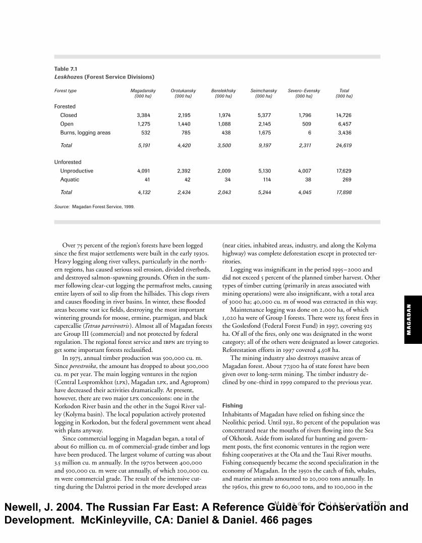
TimberThe forested lands of Magadan comprise 24,619,000 ha, or about one-third of the total area (see table 7.1). The area is categorized as follows: Group I: 7.14 percent (not including zapovednik lands); Group II: 92.86 percent. Group II forests are almost nonexistent. The main species—larch—grows on an area of 7,666,600 ha (44.91 percent of forested lands). The equivalent timber reserve is 280 million cubic meters. Dwarf Japanese stone pine occupies second place, 7,096,000 ha (41.57 percent of total forest). Shrub birch covers 1,839,300 ha (10.77 percent), and other species 468,200 ha (2.75 percent). Most forested tracts consist of low-productivity larch, with a timber density of 45 cu. m per ha, and sphagnum larch forests on waterlogged sites in valleys and on hills, with a timber density of between 20 and 70 cu. m per ha.
Newell, J. 2004. The Russian Far East: A Reference Guide for Conservation and Development. McKinleyville, CA: Daniel & Daniel. 466 pages
MA
GA
DA
N
M a g a d a n O b l a s t � 275
Over 75 percent of the region’s forests have been logged since the fi rst major settlements were built in the early 1930s. Heavy logging along river valleys, particularly in the north-ern regions, has caused serious soil erosion, divided riverbeds, and destroyed salmon-spawning grounds. Often in the sum-mer following clear-cut logging the permafrost melts, causing entire layers of soil to slip from the hillsides. This clogs rivers and causes fl ooding in river basins. In winter, these fl ooded areas become vast ice fi elds, destroying the most important wintering grounds for moose, ermine, ptarmigan, and black capercallie (Tetrao parvirostris). Almost all of Magadan forests are Group III (commercial) and not protected by federal regulation. The regional forest service and ibpn are trying to get some important forests reclassifi ed. In 1975, annual timber production was 500,000 cu. m. Since perestroika, the amount has dropped to about 300,000 cu. m per year. The main logging ventures in the region (Central Lespromkhoz (lpx), Magadan lpx, and Agroprom) have decreased their activities dramatically. At present, however, there are two major lpx concessions: one in the Korkodon River basin and the other in the Sugoi River val-ley (Kolyma basin). The local population actively protested logging in Korkodon, but the federal government went ahead with plans anyway. Since commercial logging in Magadan began, a total of about 60 million cu. m of commercial-grade timber and logs have been produced. The largest volume of cutting was about 3.5 million cu. m annually. In the 1970s between 400,000 and 500,000 cu. m were cut annually, of which 200,000 cu. m were commercial grade. The result of the intensive cut-ting during the Dalstroi period in the more developed areas
(near cities, inhabited areas, industry, and along the Kolyma highway) was complete deforestation except in protected ter-ritories. Logging was insignifi cant in the period 1995–2000 and did not exceed 5 percent of the planned timber harvest. Other types of timber cutting (primarily in areas associated with mining operations) were also insignifi cant, with a total area of 3000 ha; 40,000 cu. m of wood was extracted in this way. Maintenance logging was done on 2,000 ha, of which 1,020 ha were of Group I forests. There were 155 forest fi res in the Goslesfond (Federal Forest Fund) in 1997, covering 925 ha. Of all of the fi res, only one was designated in the worst category; all of the others were designated as lower categories. Reforestation efforts in 1997 covered 4,508 ha. The mining industry also destroys massive areas of Magadan forest. About 77,500 ha of state forest have been given over to long-term mining. The timber industry de-clined by one-third in 1999 compared to the previous year.
Fishing Inhabitants of Magadan have relied on fi shing since the Neolithic period. Until 1931, 80 percent of the population was concentrated near the mouths of rivers fl owing into the Sea of Okhotsk. Aside from isolated fur hunting and govern-ment posts, the fi rst economic ventures in the region were fi shing cooperatives at the Ola and the Taui River mouths. Fishing consequently became the second specialization in the economy of Magadan. In the 1950s the catch of fi sh, whales, and marine animals amounted to 20,000 tons annually. In the 1960s, this grew to 60,000 tons, and to 100,000 in the
Table 7.1Leskhozes (Forest Service Divisions)
Forest type Magadansky Orotukansky Berelekhsky Seimchansky Severo-Evensky Total (000 ha) (000 ha) (000 ha) (000 ha) (000 ha) (000 ha)
Forested
Closed 3,384 2,195 1,974 5,377 1,796 14,726
Open 1,275 1,440 1,088 2,145 509 6,457
Burns, logging areas 532 785 438 1,675 6 3,436
Total 5,191 4,420 3,500 9,197 2,311 24,619
Unforested
Unproductive 4,091 2,392 2,009 5,130 4,007 17,629
Aquatic 41 42 34 114 38 269
Total 4,132 2,434 2,043 5,244 4,045 17,898
Source: Magadan Forest Service, 1999.
Newell, J. 2004. The Russian Far East: A Reference Guide for Conservation and Development. McKinleyville, CA: Daniel & Daniel. 466 pages

MA
GA
DA
N
276 � T H E R U S S I A N F A R E A S T
1970s. In the late 1970s and early 1980s there was a dramatic drop in the population of commercial species, after which there was a drop in the catch. Five fi shing companies were operating in the Magadan region in 1995. The largest, Magadanrybprom, with more than 2,000 employees, was privatized into a stockhold-ing company in 1994 and controls most of the region’s fi sh quotas. The smaller fi shing companies primarily catch high-value products, including crab, for export. Magadanrybprom is the leading wholesaler of fresh, frozen, and canned fi sh.16
Magadanrybprom operates thirty fi shing vessels, includ-ing three trawlers, and a processing plant. In the mid- 1990s, the company experienced serious fi nancial diffi culties, although some improvement resulted following privatiza-tion and new management. The company also expanded its other ventures, which included a hotel, restaurant, and several stores in Magadan City. Magadanrybprom seeks U.S. partners for fi shing operations, in particular for bare-boat charters for fi shing pollock, salmon, cod, crab, and other spe-cies. The company also wishes to upgrade its existing canning facilities and operations.17 The regular failure to attain humpback salmon quotas is the result of poor organization of the fi shery (too many crews and delays of the opening of the season) and an inadequate processing base. The situation with the Anadyr chum is somewhat different, although quotas are not fi lled for this species either because of the massive scale of the marine salmon driftnet fi shery, which is oriented toward the capture of the most commercially valuable species—Anadyr chum and sockeye. In 1999, salmon fi shing in the rivers of Taui became offi cially prohibited. Coastal fi shing territories do not have clearly marked boundaries because the administrative borders of licensing zones are constantly rearranged. According to lo-cal expert assessments, illegal fi shing accounts for up to three times the amount of offi cial quotas. In any case, estuarine portions of every salmon run in the Taui and Gizhiga Bays have one or more illegal brigades. The rapacious practice of caviar poaching, in which the rest of the fi sh is left to rot, is a problem in Magadan, as elsewhere in the rfe. The three fi sh hatcheries in Magadan, on the Taui, Ola, and Arman Rivers, are not under the continual attention of numerous regulatory agencies, as is the gold industry. Factors that make abusive practices possible include the fl exibility in quota distribution, limits, and areas of catch, as well as the opportunity to manipulate catch quotas (commercial and scientifi c) with the help of the Magadan branch of tinro. According to the marine inspectorate and the ibpn, salmon hatcheries using outdated Japanese technology are ecologically harmful. The newest hatchery is Yamskaya Farm, run by the Russian-Japanese joint venture Magadan-Nikkeirei and built at the end of 1994 by American contrac-tors according to Japanese designs. The projected capacity is 35 million eggs a year. To get such a huge volume of eggs for
the hatchery, large numbers of salmon will be taken from the Yama River, which is already being heavily fi shed commer-cially. According to experts, the factory’s outdated technology will cause the loss of up to 50 percent of the eggs during the incubation period. Joint fi shing ventures registering as scientifi c ventures are involved in overfi shing and illegal fi sh exports to Japan. These joint ventures rent vessels from Magadanrybprom (the coordinating body of the Magadan fi shing industry) and use quotas set by the Federal Fisheries Committee or obtained from tinro or Magadanrybprom.18
Toward sustainable developmentMikhail Krechmar
Magadan has no offi cially defi ned programs for sustainable natural resource use. In 1995 the ibpn and the Northeast Comprehensive Scientifi c Research Institute of the Far East-ern Branch of the Russian Academy of Sciences offered to develop such a program for the administration, but a lack of funds prevented its completion. Local people collect mushrooms, medicinal plants, Japanese stone pine nuts, and berries, especially raspberries, foxberries, currants, blueberries, and cloudberries. Expand-ing the nontimber forest product harvest could help diversify Magadan’s economy. Despite horrendous energy shortfalls, there has been little inclination by the Russian government or the international community to develop alternative energy sources, such as wind or tidal electric power generators.
Indigenous peoplesMikhail Krechmar
Five indigenous peoples populate Magadan: Evens, Orochi, Koryaks, Yakuts, and Chukchi. Magadan also recognizes Kamchadals (descendants of early Cossack settlers and indig-enous people) as an indigenous people of the North, but their status is sometimes disputed at the federal level. The most populous are the Evens (6,000), followed by the Koryaks (3,000). Most indigenous people live in the northern part of the Olsky and Severo-Evensky Raions. Several towns in Magadan are designated ethnic villages. These are Tauisk, Gadlya, Yamsk, and Takhtoyamsk in Olsky Raion (popu-lated mostly by Evens and Orochi); Topolyovka, Verkhne-
Newell, J. 2004. The Russian Far East: A Reference Guide for Conservation and Development. McKinleyville, CA: Daniel & Daniel. 466 pages

MA
GA
DA
N
M a g a d a n O b l a s t � 277
Paren (Koryaks), and Gizhiga (Evens, Koryaks, and Kamcha-dals) in the Severo-Evensky Raion; and Ust-Balygychan in Srednekansky Raion. Traditional nature use by the native peoples in contemporary Magadan is fi shing, reindeer herding, and hunting and gather-ing. During the Soviet period, at least two thousand native people were employed through state sub-sidies for reindeer herding; these subsidies have since disappeared. Today reindeer grazing competes with the mining industry for land in the oblast. The herding communities are thinly spread throughout tundra woodlands, and apparently today exact routes are unknown. There has been a de facto reversion to precollectiv-ization conditions, as people are taking up subsistence activities to feed themselves and their families. Coastal fi shing areas are much fewer and are associated with traditional fi shing sites that have existed for centuries. In addition to providing important economic resources, these sites are connected to the spiritual and cultural well being of indigenous people.
Legal issuesMikhail Krechmar
Today both the scale and spectrum of violations of environ-mental law have grown. They are part of the most com-mon illegal activities of the post-Soviet era. In addition to traditional forms of environmental violation (poaching, forest destruction, water and air pollution), illegal forms of mining and oil development have appeared. Sixteen federal laws outline the current legal status and relations in the realms of nature protection and resource use. The main defect of regional law is the absence of laws per-taining to environmental bonds or mitigation banking. The latter is based on a fund collected from enterprises, then held in a special bank account. When an environmental violation occurs, the cost is calculated, and the sum is then used for restoration after the closure of the enterprise. Nature protection agencies face a particularly diffi cult task in situations where harm is caused and impact needs to
be determined. In cases of oil pollution of forest or min-ing lands, environmental regulation is invoked only when environmental degradation occurs. But in forests the effects might become evident only after several years. In worsening environmental conditions, sanctions against environmental damage must be severe, practical, and clear. The various administrative organs involved have produced a mélange of laws and documents that often contradict one another, thus undermining the development of a single, unifi ed approach to determining the signifi cance or level of impact. The implementation of environmental laws is made more diffi cult by a wealth of declarative laws and an absence of regulatory laws based on practice. Another problem with en-vironmental law is the attempt of various agencies to assume control of resources, under the guise of ecologically based arguments. Local administrations (city, raion, oblast) are wary of plans to create protected areas or change the status of existing ones. From their perspective, such designations inevitably lead to the loss of local control of these areas. A visible example is the unwillingness of authorities to give federal-level status to the Odyan or Kavinkskaya Valley Zakazniks for the stated rea-son that this will turn over control of these reserves to central protection and resource-use agencies. This very reason is the source of continual confrontation between the oblast admin-istration and the zapovednik. The zapovednik is viewed by local authorities as an external structure, and because of this, any proposals to increase its size are resisted from the outset.
!
!
!
!
!
!
!
!
!
!
!P
Yamsk
GadlyaTauisk
Evensk
MAGADAN
Topolyovka
Balygychan
Takhtoyamsk
Verkhne-Paren
Gizhiga
0 100km
Coastal fishing
Reindeer herding
Fishing and hunting
¯ KO
RY
AK
IA
Map 7.2Indigenous land usein Magadan Oblast S A K H A
By Newell and Zhou / Sources: Krechmar, 2000; ESRI, 2002.
Kolym
aR.
Kava R.
Omolon R.
Ola R.
S e ao f
Ok
ho
t s k
C H U K O T K A
Newell, J. 2004. The Russian Far East: A Reference Guide for Conservation and Development. McKinleyville, CA: Daniel & Daniel. 466 pages

MA
GA
DA
N
278 � T H E R U S S I A N F A R E A S T
Okhotskrybvod. Until recently this was Magadan’s largest nature-protection agency and, with almost exclusive control of fi shing quota distribution, an economically infl uential organization. Today, however, a signifi cant number of the staff has been transferred to a newly organized division of the Federal Border Service, which specializes in the protection of marine fi sheries. Nevertheless, Okhotskrybvod has its own high-quality fi sheries control department, with more than thirty inspectors equipped with jeeps, motorboats, and night surveillance equipment. However, Okhotskrybvod is subservient to the Federal Fisheries Committee, which many feel has little interest in protecting fi sheries. Okhotskrybvod has irregular recruiting practices and has hired people who have been laid off from security agencies and even convicted criminals. Inspectors have been involved in several suspicious homicides. Inspec-tors are often drunk on the job, and fi shermen are routinely physically harassed and beaten. The extent of fi sh poaching
that now occurs in the Magadan would be impossible if the inspectors carried out their responsibilities.
Magadan Committee on Environmental Protection. Orga-nized in 1988, but now defunct, the committee was made up primarily by offi cials from the Kolyma Basin Author-ity on Water Protection, construction engineers, and some staff from Okhotskrybvod. Many members of the staff had no specialized background in environmental protection, in law, or even biology. The scope of the responsibilities of the committee was so broad and there were so few staff members (thirty-fi ve) that implementing their duties was diffi cult. Nevertheless, the committee was the least corrupt environ-mental agency in the oblast.
Magadan Hunting Service. The department is accountable to both the Agricultural Division of the oblast administration and to the Magadan Hunting Service. Many staff members
of this agency have expertise (as hunting specialists or lawyers), but resources for protection are practically nonexistent.
PerspectiveAlexander King, Josh Newell
Since the early 1990s, multinational min-ing corporations, with fi nancial assistance from international institutions such as the International Finance Corporation (ifc), the European Bank for Reconstruction and Development (ebrd), and the U.S. Overseas Private Investment Corporation (opic), have steadily increased their involvement in and control over gold and silver mining in Magadan. Foreign interests largely con-trol the region’s biggest gold producer, the Kubaka mine, and have large stakes in the Dukat and Julietta mines.19 Environmentalists, in particular the California-based Pacifi c Environment, have raised concerns about the environmental and social effects of the Kubaka and Julietta projects. Below we profi le the major mining projects in the region, directing attention to the role of foreign investment.
Kubaka. Located in Severo-Evensky Raion, 700 km northeast of Magadan City, the Kubaka project was the fi rst joint venture Yakuts have only recently moved into the Magadan region, settling primarily in
villages along the western border.
Newell, J. 2004. The Russian Far East: A Reference Guide for Conservation and Development. McKinleyville, CA: Daniel & Daniel. 466 pages

MA
GA
DA
N
M a g a d a n O b l a s t � 279
to be a given a mineral deposit license in the Russian Federation. In terms of production, the proj-ect has been hugely successful; the 13 metric tons of gold pro-duced in 2000 represent almost half of all the gold produced in Magadan. The Russian-American fi rm Omolon Gold Mining Company holds the license for the deposit. The American partner was Amax Gold, Inc., which then sold its share to the Canadian Kinross Gold Corporation.20 Kinross con-trols 53 percent of Omolon. The Russian partners are AO Geo-metal Plus (25 percent), Magadan Silver and Gold Company (7 percent), Russian Credit Bank (7 percent), and a local organiza-tion of shareholders that includes the Severo-Evensky Raion sec-tion of the Russian Association of Indigenous Peoples of the North (raipon), which holds 7 percent. opic and the ebrd provided a total of $130 million in loans and $150 million in insurance for the project. Kilborn Engineering Pacifi c, Ltd. (Vancouver, Canada), which in 1993 was contracted to develop technological and economic foundations for constructing the mining facility at Kubaka, estimated gold reserves of 1.627 million ounces at an average grade of 16.08 grams per ton and 2.2 million ounces of silver at 21.67 grams per ton. The deposit is being exploited by open-pit mining and 630,000 tons of ore are extracted each year. Cyanide and water pressure are used to extract the gold ore. The Kubaka mine has a further 16 tons of gold at the Severo-Evensky deposit.21 Environmental impact. Some environmental groups claim opic and the ebrd are providing fi nancing and political-risk insurance for a poorly designed mine. Pacifi c Environment, after consulting with the mine’s operators and seeing the mine in person, released a report in April 1998 that accused Kubaka project operators of altering the original design of the tailings dam and other structures critical to preventing pollu-tion; these original designs, Pacifi c Environment pointed out, were used to secure international fi nancing and Russian ap-proval at local and federal levels.22 Below are several excerpts from Pacifi c Environment’s report:
Unfortunately, based on Pacifi c Environment’s initial analysis of the problems at the Kubaka mine, it believes that it is indeed accurate to call the Kubaka mine a model—a model of a mine that could cause signifi cant
long-term environmental impacts as a result of poor design, improper implementation, and lack of public oversight. Problems include poor disclosure of design modifi cations, poor baseline data for critical precipitation models, seepage and slope settlement on the critical dam at the tailings impoundment, cyanide-contamination at an inactive tailings site on mine property, and a lack of ef-fective reclamation plans well after the mine is already in operation. The lack of timely response to public requests for information and the response with out-of-date materi-als sets [sic] a poor standard for this fi rst effort in the rfe.
Many western companies promote themselves as being more environmentally responsible than Russian mining companies. It is true that strong citizens’ and governmen-tal oversight in the United States has forced a signifi cant improvement in mining practices in the last twenty years. The early lessons from the Kubaka situation underscore the extreme diffi culty of mining in an appropriate manner in Siberia and the RFE and show that even U.S. com-panies can create signifi cant and potentially long-term environmental problems in the RFE unless there is regular and effective oversight from governmental authorities and the public.
From Pacifi c Environment’s investigation, it is clear that— despite public documents from the ebrd—the practices at the Kubaka mine are not yet “consistent with
!
!
!
!
!
!
!
!
!
!
!P
Yamsk
GadlyaTauisk
Evensk
MAGADAN
Topolyovka
Balygychan
Takhtoyamsk
Verkhne-Paren
Gizhiga
0 100km
Coastal fishing
Reindeer herding
Fishing and hunting
¯ KO
RY
AK
IA
Map 7.3Indigenous land usein Magadan Oblast S A K H A
By Newell and Zhou / Sources: Krechmar, 2000; ESRI, 2002.
Kolym
aR.
Kava R.
Omolon R.
Ola R.
S e ao f
Ok
ho
t s k
C H U K O T K A
Newell, J. 2004. The Russian Far East: A Reference Guide for Conservation and Development. McKinleyville, CA: Daniel & Daniel. 466 pages

MA
GA
DA
N
280 � T H E R U S S I A N F A R E A S T
good international mining practice.” It is incumbent on the company and the international fi nancial institu-tions—opic and ebrd—backing the project to resolve the problems at Kubaka and ensure that the mine does improve its performance to meet strict environmental standards. Pacifi c Environment suggests that opic and ebrd consider withholding any outstanding funds and suspending fi nancial backing until resolution of the above activities and that the banks and company convene an emergency multiparty working group to address the problems at the Kubaka mine.23
The Kubaka project unfortunately failed to develop a “zero-discharge” model mine. In late winter 1998, Omolon Gold Mining requested and received permission to release 74,520 cu. m of cyanide-contaminated water from the primary tail-ings pond. Because of poor design and high rainfall, water levels were critically high after only one year of operation in a pond designed for “zero discharge” over the entire life of the mine. Thus, gradual releases were performed during the spring to avoid a catastrophic spill.24
Julietta gold project. The Julietta deposit, discovered during a geological survey in 1989, is in Omsukchansky Raion, 180 km southeast of the town of Omsukchan in the northern part of the Kilgan Mountains and the upper drainage of the right tributary of the Kilgan River. In 1994, AO Dukat-geologia and Omsukchansk Mountain Geology Company (OmGGK) conducted a geological and economic review of the site. In the same year, OmGGK prepared a Declaration of Intent, on the basis of which they were granted land for a road and building site. Preliminary agreement on the site was issued by Administration Proclamation No. 149 of Omsuk-chansky Raion on June 7, 1994. In 1995, the foreign investor New Arian Resources Limited (Colorado, U.S.A.) joined OmGGK to form a zao (closed joint-stock company). The zao has rights, thanks to a license issued on April 21, 1995, to develop the ore deposit and its underground yield, to construct a gold extraction facility, a tailings dump, and employee facilities at the mine shaft. Bema Gold Corpora-tion (Vancouver, Canada) acquired 79 percent of OmGGK in April 1998. In May 1999, a federal law was passed in Russia that recognized the Magadan region as a special economic zone. This allows registered companies, like OmGGK, that are investing in Magadan to benefi t from substantial reduc-tions in various federal taxes and import duties. In May 2000, Bema acquired u.s.$10 million in fi nancial backing from the ifc and credits totaling u.s.$25 million from Bayer-ische Hypo and Vereinsbank of Germany and Standard Bank London of Great Britain.25 The company expects the project to cost approximately u.s.$75 million. In August 2000, the other partner in the project, New Arian Resources, secured u.s.$26.2 -million worth
of political-risk insurance from the Multilateral Investment Guarantee Agency (miga), a unit of the World Bank group, to support expanded operations.26 According to miga, the project will increase Russian gold production by 4 percent and create 250 jobs.27 This fi nancing was secured despite opposition from environmental groups The Julietta deposit contains initial reserves of 866,000 ounces of gold. The gold extraction facility expects to pro-duce 122,500 tons of ore and 113,000 ounces of gold equiva-lent annually, at a cost of about u.s.$93 an ounce, over the initial fi ve years of a nine-year mining life. The ore process-ing at the extraction facility involves the crushing, grinding, and cyaniding of the ore, followed by fi ltration of tailings and separation of the valuable metals. In the fi rst quarter of 2002, the Julietta mine produced about 1.5 tons of gold.
Dukat silver project. The Dukat mine, the third-largest known silver deposit in the world, is located 40 km west of the town of Omsukchan. At full production, Dukat is expected to produce about 16.8 million ounces of silver and 34,000 ounces of gold a year. The ore mineralization at Dukat extends over an area covering 2.5 km east to west and 3.5 km north to south. The two mining zones within the area are the Central and Smely (Brave). In 1980, the Dukat gok started open-pit mining with an annual ore extraction and processing capacity of 400 tons. The ore was processed at the Omsukchan enrichment factory in the town of Omsukchan. Construction of the second phase of the Dukat gok, which included an enrichment factory and a tailings pit, started in 1985, but was left unfi nished after the initial fi nancial crisis. From 1980 to 1995, Dukat was Russia’s largest producer of silver, yielding more than 2 million tons of silver. In 1997, as a result of the economic crisis, the Dukat gok ceased all mining activity and was declined a license for mineral rights. On November 17, 1997, the company Serebro (“silver”) Dukat won a competitive bid for the mineral and mining rights of the Dukat deposit. The founders of Serebro Dukat are the Canadian fi rm Pan American Silver Corporation and oao (open joint-stock company) Geometal Plus. In the spring of 1999, Serebro Dukat arranged fi nanc-ing from the ifc and began construction on the site, which required substantial repairs to the tailings dam, the mill, and other assets. In December 1999, construction work on the Dukat mine was suspended after Kaskol, a Russian company, won an auction to purchase the aboveground assets, includ-ing the old mill building, which was being renovated. A fea-sibility study in January 2000 indicated that the mine would still be profi table with a wholly new mill being constructed closer to the mine itself than the existing one purchased by Kaskol. Serebro Dukat and Pan American Silver tried unsuc-cessfully to invoke conditions of the lease of aboveground assets to force Kaskol to sell the mill at the price of u.s.$8.3
Newell, J. 2004. The Russian Far East: A Reference Guide for Conservation and Development. McKinleyville, CA: Daniel & Daniel. 466 pages

MA
GA
DA
N
M a g a d a n O b l a s t � 281
million. Pan American Silver has also lost all legal challenges made in local and federal courts, despite clear irregularities in the auction and in Kaskol’s demands.28
As of February 2002, the Russian fi rm Polymetal had secured control over 80 percent of the project and was respon-sible for project fi nancing and management. Pan American Silver holds control over the remaining 20 percent but has declined to invest additional resources in the project.
Vetrensky. This deposit is in the Tenkinsky Raion, 100 km from the raion center of Ust-Omchug and 380 km from Magadan City. The deposit was explored between 1968 and 1972, and now there is a plan for geological surveys on the fl anks and in the deeper horizons of the deposit with a goal to increase yield by two and a half or three times.
Natalka (Matrosov). Located 390 km northeast of Magadan in Tenkinsky Raion, this project is still seeking foreign investment. Current production capability is 2 tons of gold per year. A u.s.$120 -million project would increase fi nished output to 10 tons of concentrated gold per year, according to some analysts.29 Magadan mining experts say the Natalka deposit is in need of between u.s.$150 and $200 million in capital investment. Natalka has 250 metric tons of proven gold reserves and projections show up to a total of 400 metric tons. The Matrosov complex produced 1.7 metric tons of gold in 1997, slightly lower than the previous year, and 1.22 tons in the fi rst three quarters of 1998.30 At a shareholder meeting in 1998, shareholders approved a plan to create an open-stock joint-venture company for Matrosov’s Natalka deposit. It was proposed that Rudnik Matrosov hold no less than 50 percent of the charter capital in the Natalka joint venture. Placer Dome Exploration (San Jose, California), a subsidiary of Placer Dome (Vancouver, Canada), has expressed an interest in a joint venture for the Natalka deposit.
Orotukan. Orotukan consists of gold in quartz veins along with silver and tin. Portions of the deposit were mined in the 1930s and produced 30 kg of gold. Average values for the surface of the deposit are 6 grams per tons; however some
veins averaging 1 m wide grade up to 150 grams per tons. Gold reserves exceed 300 tons of gold. Geometal Plus used to own all of the mine but as of 2003 their participation is unknown.31
Nyavlenga. The project is located in the Olsky Raion. Gold and silver are found in an epithermal deposit. The average ra-tio of gold to silver is 1 :50. Open-pit and underground min-ing methods are planned. Geometal Plus owns the mine.32
Rassokha. Canadian fi rm Big Blackfoot Resources Ltd., which owns this placer gold property, is seeking foreign investment to restore and develop placer gold operations.
Shkolnoe. The high-grade Shkolnoe gold mine contains steeply dipping veins, and underground reserves are esti-mated to hold commercially extractable reserves of 10,575 kg gold. In December 1997, a feasibility study of the property was completed. Capital costs to fi nance the construction and development of the underground mine, processing plant, and surface infrastructure are estimated to be u.s.$20 million. The processing plant would have a capacity of 250 tons per day, producing an average 51,000 ounces of gold annually. Susuman Gold owns 90.2 percent of the mine, and Canadian fi rm Galaxy Online, Inc. owns 9.8 percent and an agreement to acquire up to a 50 percent interest through its subsidiary Russgold X. Investment Ltd. (Cyprus).
Berezovskaya (Dubach). The Berezovskaya property covers 95 sq km. Big Blackfoot Resources Ltd. holds a 49 percent interest in the mine through the Russian company White-foot Resources Ltd. The majority owner (51 percent) is zao Golden Kolyma.
Chai Yuri. The deposit is located about 20 km from Susuman City and just beneath what was once one of the world’s great-est placer gold deposits, which has been successfully mined since 1943 and has produced over 200 tons of gold. Ore de-posits are expected to be at least as large as those of the placer deposit. Estimated gold reserves are in the region of 3 million ounces of gold.
Newell, J. 2004. The Russian Far East: A Reference Guide for Conservation and Development. McKinleyville, CA: Daniel & Daniel. 466 pages