majid climate recharge presentation - universität …€¦ · • ground water is the source of...
TRANSCRIPT

INTERNATIONAL SWAT CONFERENCE 2015
Modeling the Impacts of Climate Change on Groundwater Recharge in the
Gharehsoo Watershed, Iran, from an Ensemble of Global Climate Model Projections
Majid Taie Semiromi and Manfred Koch
Department of Geohydraulics and Engineering
Hydrology, University of Kassel, Germany

Outline of the presentation
• Groundwater resources conditions in the global scale
• Groundwater resources conditions in Iran
• Climate change and groundwater resources
• Research objectives
• Application area
• Research methodology
• Expected results

Groundwater resources conditions in the global scale

• Ground water is the source of one third of all freshwater withdrawals, supplying an estimated 36%, 42% and 27% of the water used for domestic, agricultural and industrial purposes, respectively (Taylor et al. 2013).
• Using global hydrological models, global groundwater recharge and thus renewable groundwater resources were estimated to be 13 000–15 000 km3 yr-1 under current climate conditions, and to account for approximately one third of the total renewable water resources (Doll and Fiedler 2008, Wada et al 2010).

Groundwater resources condition in Iran

Climate in Iran

Groundwater exploitation over the time in Iran
15000
25000
35000
45000
55000
65000
75000
85000
Gro
undw
ater
utl
izia
tion
(MC
M)
Hydrological year

Climate change and groundwater
1- Direct impactChagares in recharge rate2- Indirect impactIncreasing dependency on groundwater utilization by virtue of surface water scarcity resulted from climate change impacts.

Research objectives
• Prediction of the groundwater recharge and groundwater level and budget accordingly based on climate projections by using coupled modeling SWAT-MODFLOW
• Distinguishing climate change impacts from groundwater over-exploitation impacts
• Evaluation of suitability of SWAT-MODFLOW for climate change studies on groundwater recharge
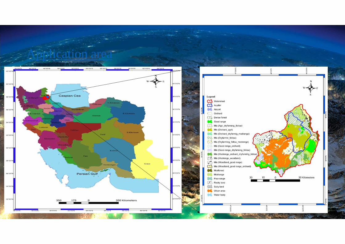
Application area

Hydroclimatology of Gharehsoo watershed
• Rainfall: Varies from 250 to 500 mm but on average 343 mm per year.
• Temperature: Changes from 4 to 14 on average in different parts of the watershed whereas the average of temperature in the whole area is about 7.4 Centigrade.
• Evaporation from the pan: With respect to the location, it fluctuates from 600 to 1400 mm per year. On average is about 1259 mm per year.

Hydrogeology of the study area
• Aquifer area: 1000.74 km^2
• Aquifer recharge~ 149.47 MCM
• Aquifer discharge~ 164.53 MCM
• Groundwater dropping ~0.27 m/yr
1324
1326
1328
1330
1332
1334
1336
1338
1340
Okt 76 Okt 79 Sep 82 Sep 85 Sep 88 Sep 91 Sep 94 Sep 97 Sep 00 Sep 03 Sep 06 Sep 09 Sep 12
Gro
undw
ater
leve
l (A
MSL
)
Time

Research methodology
Based on combined MODFLOW-SWAT the following procedure is expected:
1-The initial step is to execute and calibrate SWAT based on all available data and obtained simulated groundwater recharge for each HUR (direct recharge and transmission loss from riverbeds).
2-The groundwater recharge from SWAT’s HRUs are reformatted and feed to MODFLOW cells as the upper boundary condition.
3- MODFLOW will be executed and calibrated based on all available data and the adjusted recharge values were extracted from the MODFLOW results.

4- The MODFLOW adjusted-recharge values are sent back to SWAT as observed data.
5-Steps three and four (iteration between SWAT and MODFLOW) are repeated to achieve satisfactory results.
6- As a control, computed recharge rates are checked against the independently estimated annual mean groundwater recharge rates.

Schematic diagram of combined surface water and groundwater model (Kim and et al. 2008)

GCMs and SRES
Considered General Circulation Models:1-Canadian Global Coupled Model (CGCM 3.1)2- Hadley Centre Coupled Model, version 3 (HADCM3)Considered SRES:1- A1B2- B13- A2

Separation Climate change impacts from groundwater over- utilization impacts
1- Creating the groundwater hydrographs under both climate change impacts and current utilization of groundwater reserves.
2-Creating the groundwater hydrographs under the current situation of groundwater exploitation (Neglecting the impacts of climate change).
3- Drawing the groundwater hydrographs under climate change impacts (Cutting groundwater pumping as much as the groundwater recharge).

Groundwater dropping as a consequence of over- exploitation effects:
�� � �� � ��
Where �� denotes groundwater dropping due to over- utilization, �� shows the main groundwater hydrograph resulted from both over- abstraction and climate change impacts and �� is the groundwater hydrograph obtained from climate change impacts.
Groundwater dropping in response to climate change impacts:
�� � �� ��
Where �� denotes total dropping, �� shows the main groundwater hydrograph resulted from both over- abstraction and climate change impacts and � is the groundwater hydrograph obtained from over- abstraction of the groundwater reserves.
Based on all the time series available, the program for this separation will be provided in R programming language.

Conceptual figure of a system that is affected by both natural and anthropogenic influences (solid line), of which the ‘naturalized situation’ (dashed line) needs to be known to quantify the anthropogenic effect. The red horizontal line indicates a threshold below which the system is negatively impacted. The gridded surfaces indicate anomalies with natural causes (drought) and the vertically-striped surfaces indicate anomalies with human (water scarcity) causes (Adopted from Van Loon, 2013)

Expected results
• Groundwater level and budget will be significantly decreasing under all ensemble of climate projections.
• SWAT-MODFLOW is a powerful tool to assess climate change impacts on groundwater resources compared with using only MODFLOW.
• Most of groundwater dropping has been resulted from groundwater over-abstraction rather than drought and climate change impacts.

Thousands have lived without love,not one without water.
Thank you for your attention