martin luther king (mlk) boulevard - austin, texas · martin luther king (mlk) boulevard ... open...
TRANSCRIPT

City of Austin Neighborhood Planning and Zoning Department
MARTIN LUTHER KING (MLK) BOULEVARD TOD STATION AREA PLAN

ACKNOWLEDGEMENTSThe City of Austin would like to thank the following for their contribution to the MLK Transit-Oriented Development (TOD) Station Area Plan:
All participants in the planning process who live, work, and own or rent property in and around the MLK TOD District.
Other interested individuals who came to learn about transit-oriented development and give feedback on this citywide initiative.
Individuals and groups who are dedicated to promoting affordable housing throughout Austin.
The members of the technical advisory group who dedicated time to learning about TOD concepts, attended public meetings, and reviewed and gave feedback on the Station Area Plan throughout the planning process.
Other City staff members who made themselves available to answer technical questions and provide information on specific topics related to the Plan.
Thanks to the Thompson Conference Center, David Chapel, Conley-Guerrero Senior Center, and the Parque Zaragoza Recreation Center for providing meeting space.

TABLE OF CONTENTS
Executive Summary 1
Chapter 1 - TOD Principles and Planning Policy 15
Chapter 2 - Station Area Concept Plans 27
Chapter 3 - Implementation 61
Appendices A. Creating the Plan B. Affordable Housing Report C. Water and Wastewater Report D. Watershed Protection E. Financial Analysis F. Market Report
ES123


EXECUTIVE SUMMARYES
MLK JR. BOULEVARD TOD STATION AREA PLAN
2 PB PLACEMAKING
EXECUTIVE SUMMARYESMLK JR. BOULEVARD TOD STATION AREA PLAN
EXECUTIVE SUMMARY
INTRODUCTION
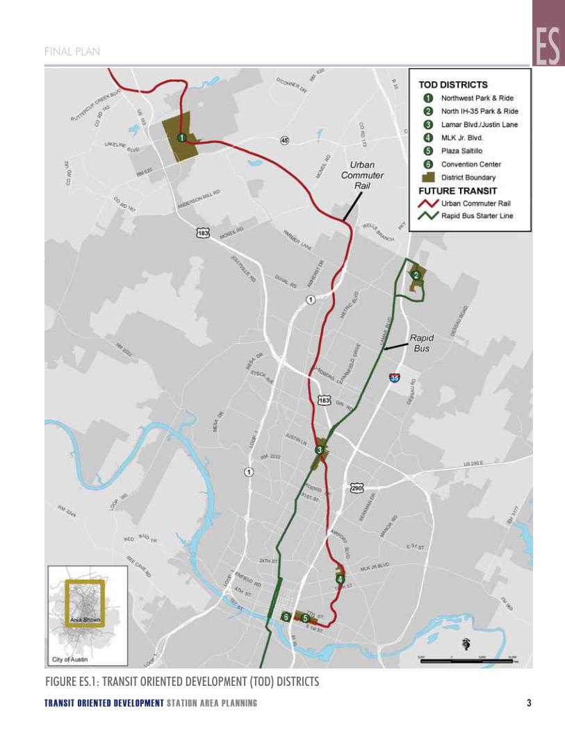
The first Capital MetroRail line is under construction with passenger service to begin at the end of 2008. The 32-mile Red Line will connect downtown Austin to Leander on existing rail tracks with nine initial stations planned. The City, in support of the Capital Metro “All Systems Go!” Long Range Transit Plan, initiated a broad public engagement effort to develop station area plans around several of these future MetroRail stops. The first station areas to undergo the station area planning process were Plaza Saltillo, Martin Luther King Jr. Boulevard (MLK), and N. Lamar Boulevard/Justin Lane (a.k.a. Crestview Station).
New development that takes advantage of its location near transit is often referred to as “Transit-Oriented Development” (or TOD), and it is an important part of the City’s goal to manage growth in ways that reduce reliance on automobile use, promote transit use, walking and biking, and create lively and safe areas around transit stations. The City of Austin developed the TOD station area plans to leverage this significant public transit investment to achieve these broad community goals.
To realize these benefits, the City first adopted a TOD Ordinance, which identified specific station area boundaries, interim land use and design requirements, and a commitment to develop station area plans. Planning for the MLK TOD was begun in February 2007 by a team of consultants led by PB Americas. Public education and involvement meetings were held over the course of the next ten months to draft a plan that incorporated TOD principles and best practices and was shaped by the community input gathered throughout the planning process. The planning work was integrated with a professional assessment of market conditions and finance, affordable housing, and basic public infrastructure and facility needs. The plan includes recommendations for open space, street and other infrastructure improvements, and affordable housing and is intended to guide future development and the provision of public improvements.
The implementation strategy describes a variety of key actions that will contribute to the successful redevelopment of the station area. The responsibilities for implementation not only rest with the City, but its agency partners, development community, and citizens. A primary element of the implementation program is the MLK TOD Station Area Regulating Plan. It is based on Subchapter E: Design Standards and Mixed Use of the Austin Code, which applies citywide. The Regulating Plan provides development standards with a specific focus on the context of the MLK Station Area and the vision articulated in this plan.
FINAL PLAN
TRANSIT ORIENTED DEVELOPMENT STATION AREA PLANNING 3
FINAL PLAN ES
FIGURE ES.1: TRANSIT ORIENTED DEVELOPMENT (TOD) DISTRICTS

4 PB PLACEMAKING
Martin Luther King Jr. Boulevard (MLK) station planning area was identified in the TOD Ordinance to include the Boggy Creek flood plain and the area to the west along Manor Road and MLK Jr. Boulevard. During the development of this plan, the planning area was expanded to include land around the Airport Boulevard intersections with Manor Road and MLK Jr. Boulevard. It includes portions of four neighborhood planning areas - Chestnut, MLK, Rosewood, and Upper Boggy Creek, and several neighborhoods within these.
PLAN ORGANIZATION
The consultant team, informed by community input throughout the planning process, developed the MLK TOD Station Area Plan, which
Followed transit-oriented design principles and Austin planning policy as described in Chapter 1;• Is summarized below and described in more detail in Chapter 2;• Includes an implementation strategy described in Chapter 3;• Featured an inclusive public involvement process as described in the Appendix; and• Utilized background information and studies presented in a series of appendices. •
PLAN SUMMARY
The MLK TOD Station Area Plan includes three primary elements:Land Use and Design Concept Plan• , which describes the desired land uses and development characteristics in the TOD.Circulation Concept Plan• , which identifies the functional and design elements for streets and walkways.Open Space and Trails Concept Plan• , which describes the important open space components of the TOD.
The concept plan maps and summary of the key elements are presented on the following pages.
ES EXECUTIVE SUMMARYEXECUTIVE SUMMARY

FINAL PLAN
TRANSIT ORIENTED DEVELOPMENT STATION AREA PLANNING 5
FINAL PLAN
FIGURE ES.2: LOCATION MAP OF MLK TOD WITH NEIGHBORHOOD PLANNNING AREAS
ES

6 PB PLACEMAKING
LAND USE AND DESIGN CONCEPT PLAN
The Land Use and Design Concept for the MLK TOD Station Area Plan includes five land use designations:
TOD Mixed-Use.• This is the highest density designation, which encourages urban-style development including active ground floor uses with commercial, office, or residential uses on the upper floors. Residential densities may exceed 45 units per acre if a specific level of affordable housing is provided. Moderate height bonuses allowing a total building height of 60ft may also be granted with additional affordable housing. These areas are located in the closest proximity to transit and are intended to become neighborhood centers.
Corridor Mixed-Use.• This allows a slightly more liberal mix of uses compared to TOD Mixed-Use. These properties are farther from the transit station and have less of an urban character compared to TOD Mixed-Use. Normal residential densities may reach 45 units per acre, and additional density may be permitted when affordable housing is provided.
ES EXECUTIVE SUMMARYEXECUTIVE SUMMARY

FINAL PLAN
TRANSIT ORIENTED DEVELOPMENT STATION AREA PLANNING 7
FINAL PLAN
Live/Work Flex.• This encourages ground floor business activity with residential units on the upper floors. Residential uses are required and a ground floor business is optional. Residential densities range from 17 to 45 units per acre, and additional density may be permitted when affordable housing is provided.
Medium Density Residential.• This designation is found outside of the mixed-use areas and is intended to provide a transition into the surrounding neighborhoods. Residential densities range from 17 to 45 units per acre.
Low Density Residential.• This designation also provides a transition between the higher density center of the station area and surrounding neighborhoods. Residential densities range from 9 to 16 units per acre.
ES
8 PB PLACEMAKING
LAND USE AND DESIGN CONCEPT PLANThe Land Use and Design Concept Plan includes the following primary elements:
High density mixed-use development 1. concentrated near the Capitol Metro station on Alexander Avenue, south of MLK Jr. Boulevard. This would be the primary activity area in the station area.A secondary concentration of high density mixed-use development2. is located along Manor Road and Alexander Avenue to take advantage of the planned streetcar line on Manor Road, and the potential additional Capitol Metro stop on Manor.Active edges,3. which create a more lively and pleasant pedestrian environment by requiring buildings along specific street frontages to be built up to the sidewalk with the ground floor designed to accommodate active business uses. The active edge designation is only used with the TOD Mixed-Use designation.Live/work uses 4. where small businesses would be allowed with residential units above. This is in response to neighborhood support for this type of use and for creating a transition between the higher density core and the lower density neighborhoods surrounding it.Low and Medium Density Residentia5. l uses in selected transition areas adjacent to existing neighborhoods.Gateways6. at the intersections of Airport Boulevard with Manor Road and MLK Jr. Boulevard, which feature improved pedestrian facilities and amenities as well as a more urban character to signify entry into the MLK station area.
ES EXECUTIVE SUMMARY

FINAL PLAN
TRANSIT ORIENTED DEVELOPMENT STATION AREA PLANNING 9
LAND USE AND DESIGN CONCEPT PLAN
6
6
5 5
2
3
3
1
4

10 PB PLACEMAKING
CIRCULATION CONCEPT PLAN
The Circulation Concept for the MLK TOD Station Area Plan includes the following primary elements:
An integrated street and pathway network1. to provide safe and convenient travel for all modes of transportation.TOD Core Transit Corridor2. design standards for Manor Road and MLK Jr. Boulevard, which require wider sidewalks and enhanced pedestrian facilities to support the existing and planned transit service.TOD Pedestrian Priority Streets3. , which are also required to have enhanced pedestrian facilities because they will serve as the primary pedestrian routes in the station area. Alexander Avenue and portions of E. 17th Street and Real Street are so designated.New pedestrian connections4. from Pannell Place and E. 16th Street to provide easier access between the station and these neighborhoods.New local streets5. as properties redevelop to provide smaller, more walkable blocks.A trail system along Boggy Creek6. and/or the rail line with possible on-street connections to provide enhanced pedestrian and bicycle access and recreational opportunities through the station area. There are different trail proposals that could be realized and they are not mutually exclusive of each other. The community expressed a desire for both a natural trail system along the creek for mainly recreational purposes and also a multi-use “Rails with Trails” pathway generally along the rail line that could serve both recreational and functional transportation needs.On-street bicycle facilities7. to encourage bike riding and make it safe and efficient to ride around and through the TOD.
ES EXECUTIVE SUMMARY

FINAL PLAN
TRANSIT ORIENTED DEVELOPMENT STATION AREA PLANNING 11
CIRCULATION CONCEPT PLAN
6
5
2
3
1
4
2
4
7

12 PB PLACEMAKING
OPEN SPACE AND TRAILS CONCEPT PLAN
The Open Space and Trails Concept Plan for the MLK TOD Station Area Plan includes the following primary elements:
Boggy Creek1. and the area along its course are restored providing a natural open space area for local residents that could include space for community gardens. The pedestrian connections and potential trail extension in the Circulation Concept Plan will improve access to this area.Pocket park between Manor Road and MLK Jr. Boulevard2. to provide convenient recreation opportunities for local residents. The park is recommended to be a minimum of one-half acre.Pocket park south of MLK Jr. Boulevard3. to provide convenient recreation opportunities for local residents. The park is recommended to be a minimum of one-half acre.A trail system along Boggy Creek4. and/or the rail line with possible on-street connections to provide enhanced pedestrian and bicycle access and recreational opportunities through the station area. There are different trail proposals that could be realized, and they are not mutually exclusive of each other. The community expressed a desire for both a natural trail system along the creek for mainly recreational purposes and also a multi-use “Rails with Trails” pathway generally along the rail line that could serve both recreational and functional transportation needs.
IMPLEMENTATION
Chapter 3 Implementation describes a variety of important steps the City, its agency partners, and development community should take to realize the full potential of the station area:
Planning and Administration.• The critical element is the formation of an inter-agency working group and designated staff to oversee all implementation activities.Transit-Oriented Development Catalyst Projects. • Catalyst projects, both public infrastructure and private development, will be necessary to stimulate market and development interest in the station area.Circulation and Streets.• Street improvements, including pedestrian facilities and amenities, can have a dramatic positive impact upon a place’s identity and can create the framework for creating a truly transit-oriented development that is less auto-dependent.Open Space and Trails. • Building upon the natural resources in the area, integration of the Parks and Recreation Department in planning and development review decisions, and creation of usable open spaces are essential.Supporting Infrastructure.• Key public-private investments will need to be made to support the development proposed.
ES EXECUTIVE SUMMARY

FINAL PLAN
TRANSIT ORIENTED DEVELOPMENT STATION AREA PLANNING 13
OPEN SPACE AND TRAILS CONCEPT PLAN
2
31
4


CHAPTER 1TOD PRINCIPLES AND PLANNING POLICY
1

16 PB PLACEMAKING
TOD is a strategy available to help manage growth and improve the quality of life in Central Texas. TOD provides communities with an alternative to low-density suburban sprawl and automobile-dependent land use patterns.
TOD seeks to align transit investments with a community’s vision for how it wants to grow, creating “livable” mixed-use, denser, walkable “transit villages.” A successful TOD will reinforce both the community and the transit system.
In general, people living and working in TODs are more likely to walk, use transit, and own fewer cars. TOD households are twice as likely to not own a car and own roughly half as many cars as the “average” household. At an individual station, TOD can increase ridership by 20 to 40 percent and even cause significant change at a regional level. People who live in a TOD are five times more likely to commute by transit than other residents. Locations next to transit can enjoy increases in land values over 50 percent in comparison to locations away from transit stops.
WHAT IS TRANSIT ORIENTED DEVELOPMENT (TOD)?
“Transit Oriented Development (TOD) is moderate to higher density development, located within an easy walk of a major transit stop, generally with a mix of residential, employment and shopping opportunities designed for pedestrians without excluding the auto. TOD can be new construction or redevelopment of one or more buildings whose design and orientation facilitate transit use.”
California Department of Transportation TOD Study Technical Advisory Committee, January 2002.
TOD PRINCIPLES AND PLANNING POLICY
TOD DESIGN PRINCIPLESThe City of Austin Neighborhood Planning and Zoning Department prepared a TOD Guidebook to create a shared understanding of TOD and also to identify the major design principles and factors for success. Transit-oriented development may be summarized by using four key principles, which define the essential characteristics of all successful TODs: 1. Greater density than community average2. A mix of uses3. Quality pedestrian environment4. A defined center
These four principles directly influence the land use, circulation, and design concepts of the Austin station area planning as well as the Regulating Plan elements that support it.
A common thread running through the TOD principles is the importance of establishing a unique neighborhood identity that is memorable. Improvements in public spaces, ranging from civic buildings, plazas, and streets to street signs, light fixtures and standards, specific street tree species, and pedestrian area paving materials can be used to create a unique sense of place for different city neighborhoods. Austin has many historic and emerging areas that are known for their physical character and design sensibilities. The TOD is intended to enhance the character of the overall area and the neighborhood plans that the MLK Station Area is a part of will be very informative in this regard.
FINAL PLAN
TRANSIT ORIENTED DEVELOPMENT STATION AREA PLANNING 17
FINAL PLAN
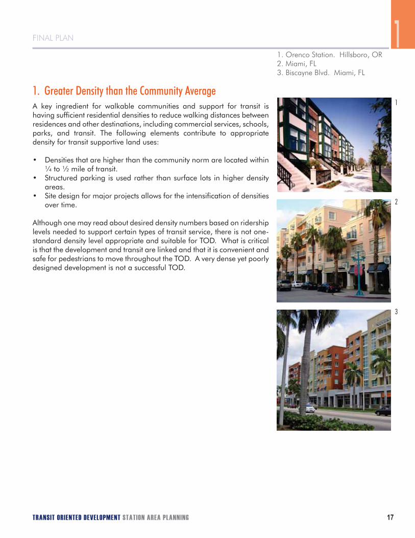
1. Greater Density than the Community AverageA key ingredient for walkable communities and support for transit is having sufficient residential densities to reduce walking distances between residences and other destinations, including commercial services, schools, parks, and transit. The following elements contribute to appropriate density for transit supportive land uses:
Densities that are higher than the community norm are located within • ¼ to ½ mile of transit.Structured parking is used rather than surface lots in higher density • areas.Site design for major projects allows for the intensification of densities • over time.
Although one may read about desired density numbers based on ridership levels needed to support certain types of transit service, there is not one- standard density level appropriate and suitable for TOD. What is critical is that the development and transit are linked and that it is convenient and safe for pedestrians to move throughout the TOD. A very dense yet poorly designed development is not a successful TOD.
1
2
3
1. Orenco Station. Hillsboro, OR2. Miami, FL3. Biscayne Blvd. Miami, FL
1

18 PB PLACEMAKING
2. A Mix of UsesOne of the most visually distinguishable features of a TOD is the active streetscape, which is oriented towards pedestrians. A mix of uses is required to create multiple destinations around the transit station, which helps to generate pedestrian traffic. An active, lively environment can change the perception of distances, making destinations seem shorter and more walkable. A transit-supportive environment includes a mixture of residential, commercial, service, employment, and public uses making many trips between destinations shorter and more walkable. In addition:
First floor uses are “active” and oriented to serve pedestrians.• Multiple compatible uses are permitted within buildings near transit.• A mix of uses generating pedestrian traffic is concentrated within • walking distance (¼ to ½ mile) of transit.Auto-oriented uses, such as service stations and drive-through facilities, • are limited or prohibited near transit.
1
1. Vancouver, B.C.2. Santana Row. San Jose, CA
2
181818181811181818181818181811818181811181111111811818118181881888818818 PBPBPBPBPBPBPPBPBPBPBPBPBPBPBPB PLPLPLPLPPLLPLPLPLPLPLPLLP ACACACACACACACACACCACCACACACCCACA EMEMEMEMEMEMEMEMMEEMEMMEMEMEMEMEEEEMEEEEEEEMEMMEEEEEMEEMEEEEEEEEEMEMEMMEEEMEEME AKAKAKAAKAKAAAKAKKKKKKKKAKKKKKKKKAAKKKKKKKKKKKKKAKAKKKKAKKKKAKKKKKKKKKKKKKKKKKKKKKKKKKKKININIINININININININININNIININININNINIININININNININININININNNNINNNININNNINNNINNNNI GG GGGGGGGGGGGGGGGGGGGGGGGGGGGGGGG GGGG
TOD PRINCIPLES AND PLANNING POLICY

FINAL PLAN
TRANSIT ORIENTED DEVELOPMENT STATION AREA PLANNING 19
FINAL PLAN
3. Quality Pedestrian EnvironmentVibrant communities, with or without transit, are always convenient and comfortable places for pedestrians. There are a number of components that contribute to a quality pedestrian environment:
Buildings and primary entrances are sited and oriented to be easily • accessible from the street.Buildings incorporate architectural features that convey a sense of • place and relate to the street and the pedestrian environment.Amenities, such as storefront windows, awnings, architectural features, • lighting, and landscaping, are provided to help create a comfortable pedestrian environment along and between buildings.The site layout and building design allow direct pedestrian movements • between transit, mixed land uses, and surrounding areas.Most of the parking is located to the side or to the rear of the • buildings.Sidewalks are present along site frontages, which connect to sidewalks • and streets on adjacent and nearby properties.Street patterns are based on an interconnected grid system that • simplifies access for all modes.Pedestrian routes are buffered from fast-moving traffic and expanses • of parking.Trees sheltering streets and sidewalks are provided along with • pedestrian-scale lighting.Buildings and parks are used to provide a focal point or anchor for • key areas or intersections.Secure and convenient bicycle parking is available.•
1. New York City, NY2. City Place. West Palm, FL3. Ft. Lauderdale, FL4. Orenco Station. Hillsboro, OR
2
3
41
1

20 PB PLACEMAKING
4. A Defined CenterTransit is particularly successful in communities and neighborhoods that have defined centers, offering multiple attractions and reasons for pedestrians to frequent the area. Having different zones with distinct characteristics also helps to create a sense of place. This sense of place may be created by including at least several of the following attributes:
The density and buildings are highest in the core near the transit • station, moderating somewhat in the center that is within ¼ mile of the transit station, and ultimately transitioning in the edge to match the character of surrounding development approximately ½ mile from the station.Buildings are located closer to the street and are typically taller than • the surrounding area.Buildings are primarily oriented to the street with windows and main • entrances.Parking is less predominant, being located to the rear and in parking • structures. Parking requirements are reduced in close proximity to transit, compared to the norm.Sidewalks are wider than in lower density areas, and offer pedestrian • amenities, such as street trees, benches, kiosks, and plazas.
1. Birkdale Village, Charolette, NC2. Clarendon. Arlington, VA3. Addison Circle. Dallas, TX4. Core Center Edge Diagram - Illustrates development patterns in a TOD
2
3
4
1
TOD PRINCIPLES AND PLANNING POLICY

FINAL PLAN
TRANSIT ORIENTED DEVELOPMENT STATION AREA PLANNING 21
FINAL PLAN
BENEFITS OF TOD
By implementing TOD and coordinating investment in transportation and land use projects, communities can make significant progress toward improving their quality of life. The extent to which this progress is made depends largely on the type and quality of transit service available as well as the primary characteristics of the TOD. Ten major benefits from TOD are:
1. Providing mobility choices. By creating “activity nodes” linked by transit, TOD provides much needed mobility, including options for young people, the elderly and people who do not own cars or prefer not to drive.
2. Increasing public safety. By creating active places, which are busy through the day and evening and providing “eyes on the street”, TOD helps increase safety for pedestrians, transit users, and many others.
3. Increasing transit ridership. TOD improves the efficiency and effectiveness of transit service investments by increasing the use of transit near stations by 20 to 40 percent, and up to five percent overall at the regional level.
4. Reducing rates of vehicle miles traveled (VMT). Vehicle travel has been increasing faster than population growth. TOD can lower annual household rates of driving by 20 to 40 percent for those living, working, and/or shopping within transit station areas. Recent research shows that automobile ownership in TOD is approximately one-half the national average.
5. Increasing disposable household income. Housing and transportation are the first and second largest household expenses, respectively. TOD can effectively increase disposable income by reducing the need for more than one car and reducing driving costs, saving households $3,000-4,000 per year.
6. Reducing air pollution and energy consumption rates. By providing safe and easy pedestrian access to transit, TOD can lower rates of air pollution and energy consumption. TOD can also reduce rates of greenhouse gas emissions by 2.5 to 3.7 tons per year per household.
7. Helping protect existing single-family neighborhoods. TOD directs higher density development to appropriate areas near transit, thereby reducing pressure to build higher density development adjacent to existing single-family neighborhoods.
8. Playing a role in economic development. TOD is increasingly used as a tool to help revitalize aging downtowns and declining urban neighborhoods and to enhance tax revenues for local jurisdictions.
9. Contributing to more affordable housing. TOD can add to the supply of affordable housing by providing lower-cost and accessible housing, and by reducing household transportation expenditures. It was recently estimated that housing costs for land and structures can be significantly reduced through more compact growth patterns.
10. Decreasing local infrastructure costs. Depending on local circumstances, TOD can help reduce infrastructure costs (such as for water, sewage, and roads) to local governments and property owners by up to 25 percent through more compact and infill development.
1

22 PB PLACEMAKING
AUSTIN’S TOD POLICY CONTEXT
The Transit-Oriented Development OrdinanceStation area plans are influenced by existing plans and policies adopted by the Austin City Council. Most important is the Transit-Oriented Development Ordinance adopted by the City Council in May 2005. The ordinance established a two-phased implementation process for TOD districts. The first phase, now completed, accomplished the following:
Created four TOD types and designated a TOD type for each of the • stations;Developed TOD districts around the stations to delineate between • areas appropriate for redevelopment and established neighborhoods that would be protected;Created a TOD overlay zoning district for each station area;• Adopted interim development regulations relating to use, site • development standards, and parking as part of the TOD overlay zone; andEstablished a station area planning process.•
The second phase involves the creation of station area plans that, when adopted, will replace the interim TOD Ordinance regulations. The MLK Jr. Boulevard station area is designated as a Neighborhood Center TOD. This type of TOD is located at the commercial center of a neighborhood(s).
The TOD Ordinance requires a housing affordability analysis and feasibility review as part of all station area plans, which describes potential strategies for achieving specified affordable housing goals. A housing affordability analysis was undertaken concurrent with the station area planning, and it is summarized in Chapter 2.
City of Austin Design Standards In addition to the TOD Ordinance, the Austin City Council amended the City’s Land Development Code in 2006 to add Subchapter E: Design Standards and Mixed Use. This portion of the Land Development Code, which applies city-wide, includes design standards, which “aim to strengthen Austin’s unique character and help buildings to better function in Austin’s environment.” The majority of the design standards are based upon several defined roadway types to help ensure a cohesive development pattern along city streets, and reduce the inconsistent development form that can be the product of various zoning districts, which abut them. Subchapter E includes standards for site development, building design, and mixed-use.
TOD PRINCIPLES AND PLANNING POLICY

FINAL PLAN
TRANSIT ORIENTED DEVELOPMENT STATION AREA PLANNING 23
FINAL PLAN
As a first step towards implementing the MLK TOD Station Area Plan, a Regulating Plan was developed with a specific set of land use and urban design standards. Because the current Design Standards share many of the land use and design objectives of the TOD station area plans, such as creating a more enriching pedestrian environment and ensuring that buildings relate better to the street, it provided the foundation for the MLK TOD Regulating Plan. The MLK TOD standards in the Regulating Plan are tailored to help implement the land use, circulation, and urban design elements of the station area plan and replace the citywide Subchapter E standards within the TOD planning area.
Neighborhood PlansSurrounding the MLK TOD are several neighborhoods that form four separate neighborhood planning areas. The four neighborhood plans that intersect the MLK TOD and specific goals of each plan that relate to transit-oriented development are highlighted below:
Chestnut Neighborhood Plan has four goals, which relate to this plan:
Goal 1 – Revitalize the historic, residential and pedestrian-friendly • character of Chestnut.Goal 2 – Environment and Parks: Improve the environmental quality • of the neighborhood.Goal 3 – Housing: Promote the rehab of existing housing and new, • infill housing compatible with the old style of the neighborhood.Goal 4 – Economic development: Improve the business climate of • Chestnut.
East MLK Combined Neighborhood Plan (MLK Planning Area) has ten goals, which relate to this plan:
Goal 1 – Preserve established residential areas and improve • opportunities for home ownership by promoting the rehabilitation of existing housing and new, infill housing compatible with the existing style of this neighborhood.Goal 2 – Promote a mix of land uses that respect and enhance the • existing neighborhood and address compatibility between residential, commercial, and industrial uses.Goal 3 – Preserve existing small businesses and encourage new • neighborhood-serving commercial services in appropriate locations.Goal 4 – Promote the development and enhancement of the • neighborhood’s major corridors.Goal 5 – Provide housing that helps maintain the social and economic • diversity of residents.
1. Neighborhood Plans around the MLK TOD district.2. Chestnut Neighborhood Plan.3. East MLK Neighborhood Plan.
1
2
3
1

24 PB PLACEMAKING
Goal 6 – Protect and enhance historic resources and structures and • preserve the area’s historic and cultural character.Goal 7 – Create a transportation network that allows all residents • to travel safely throughout the neighborhood by improving safety on major arterials and neighborhood streets.Goal 8 – Provide access to, from, and through the neighborhood • for all residents by promoting a neighborhood-friendly system of transportation.Goal 9 – Improve bicycle and pedestrian traffic safety on neighborhood • streets.Goal 13 – Create more public open space, including parks and green • spaces, improve existing parks and increase recreational amenities in the neighborhood.
Rosewood Neighborhood Plan has five goals, which relate to this plan:
Goal 1 – Make the Rosewood Neighborhood Planning Area a more • attractive, cleaner and safe place to live.Goal 2 – Promote affordable housing options while reducing the • number of vacant lots.Goal 3 – Create a transportation network that allows all residents to • travel safely throughout the neighborhood.Goal 4 – Promote commercial uses that serve the needs of residents • (e.g., a grocery store).Goal 5 – Preserve and enhance the character of the Rosewood • Neighborhood.
at
1. East MLK Neighborhood Plan.2. Rosewood Neighborhood Plan.
2
1
TOD PRINCIPLES AND PLANNING POLICY

FINAL PLAN
TRANSIT ORIENTED DEVELOPMENT STATION AREA PLANNING 25
FINAL PLAN
Upper Boggy Creek Neighborhood Plan has five goals, which relate to this plan:
Goal 1 – Preserve the character of each neighborhood in the UBC • Planning Area.Goal 2 – Ensure that new business and commercial development is • neighborhood-appropriate, neighborhood-scaled, neighborhood-friendly, and serves the nearby neighborhoods.Goal 3 – Promote the rehab of existing housing and construction of • new housing to be compatible with the surrounding neighborhood and architecture for a variety of income levels.Goal 4 – Improve the quality of residential streets and commercial • corridors to make them safe, accessible, and attractive to all forms of transportation. Residential and commercial streets and transit should:
– Emphasize pedestrian and bicycle safety– Serve pedestrian and bicycle convenience– Encourage public transit use– Allow residents ready ingress and egress from the
neighborhood– Limit through-traffic to roads designated for the purpose– Be compatible with the residential/mixed-use character of the
neighborhoodsGoal 5 – Achieve and maintain a healthy, sustainable, robust, • functional, and aesthetically beautiful parks and green space system that provides active and passive recreational opportunities for all residents.
The above neighborhood plans will be amended when the MLK TOD Station Area Plan is adopted by the City Council to reflect the most recent planning effort that has occurred for the properties within the MLK TOD District.
1
1.Upper Boggy Neighborhood Plan.
1


CHAPTER 2MLK JR. BOULEVARD TOD STATION AREA PLAN
2

The commercial area and neighborhoods surrounding the MLK Jr. Blvd. Station are vibrant, green, and attractive. The area derives its unique character from the juxtaposition of three distinct elements: an enhanced and green Boggy Creek corridor, historic and stable single-family neighborhoods, and a vibrant and attractive center with an active streetscape, local-serving retail, and quality mixed-use development.
MetroRail provides frequent all-day service between downtown Austin and Leander. A streetcar on
Manor Road serves the neighborhood and provides direct connections to the University of Texas and
the Mueller redevelopment. The transportation system is well integrated and provides easy transfer
between commuter rail, streetcar, buses, and bicycles. Direct and safe walking routes along streets and multi-use paths are provided. New
development is oriented to the pedestrian.
The Vision for the MLK Jr. Blvd. TOD Station Area in 2020..

Buildings closest to the station reach heights of six stories and gracefully step down towards the older single-family neighborhoods. The buildings are made of quality materials and are visually interesting with balconies, generous windows, and a diversity of styles. Along major streets, the buildings include active uses on the ground floor such as restaurants, coffee shops, stores, and offices. Parking is screened from view behind buildings and in parking structures.
MLK Jr. Boulevard and Manor Road are attractive and safe streets with sidewalks wide enough for outdoor seating, new lighting fixtures, streets trees, marked crosswalks, and on-street parking to serve the retail. Ecologically-friendly approaches to storm water management such as landscaped swales are used throughout the area.
Finally, the natural environment is seamlessly integrated into the district. Boggy Creek is restored, healthy, and accessible to the public, providing a green spine running north and south through the district. Street trees and pocket parks continue the green character of Boggy Creek into the neighborhoods.

30 PB PLACEMAKING
THE DESIGN CHALLENGE
During a public meeting, one participant described the MLK TOD district as “the hole in the donut.” This was in reference to the large undeveloped portion of the site at the center of the district, which was formerly occupied by the Featherlite concrete plant and other industrial uses. Indeed, this former industrial land provides a huge opportunity as it is essentially a blank slate for redevelopment adjacent to the future rail platform. The design challenge for this station area is to create a vital and active center near the station while protecting and enhancing the single family neighborhoods and the natural resources surrounding the site.
THE VISION The MLK Jr. Boulevard TOD Station Area Plan will lay the foundation for achieving the MLK Station Area vision and realize the mixed-use environment and atmosphere desired by the Chestnut, Rosewood, Upper Boggy Creek, and East MLK Neighborhood Plans. The Vision Statement on the previous pages was crafted from the major themes discussed during the public workshops.
CREATING THE MLK JR. BOULEVARD TOD STATION AREA PLAN
MLK JR. BLVD. TOD STATION AREA PLAN
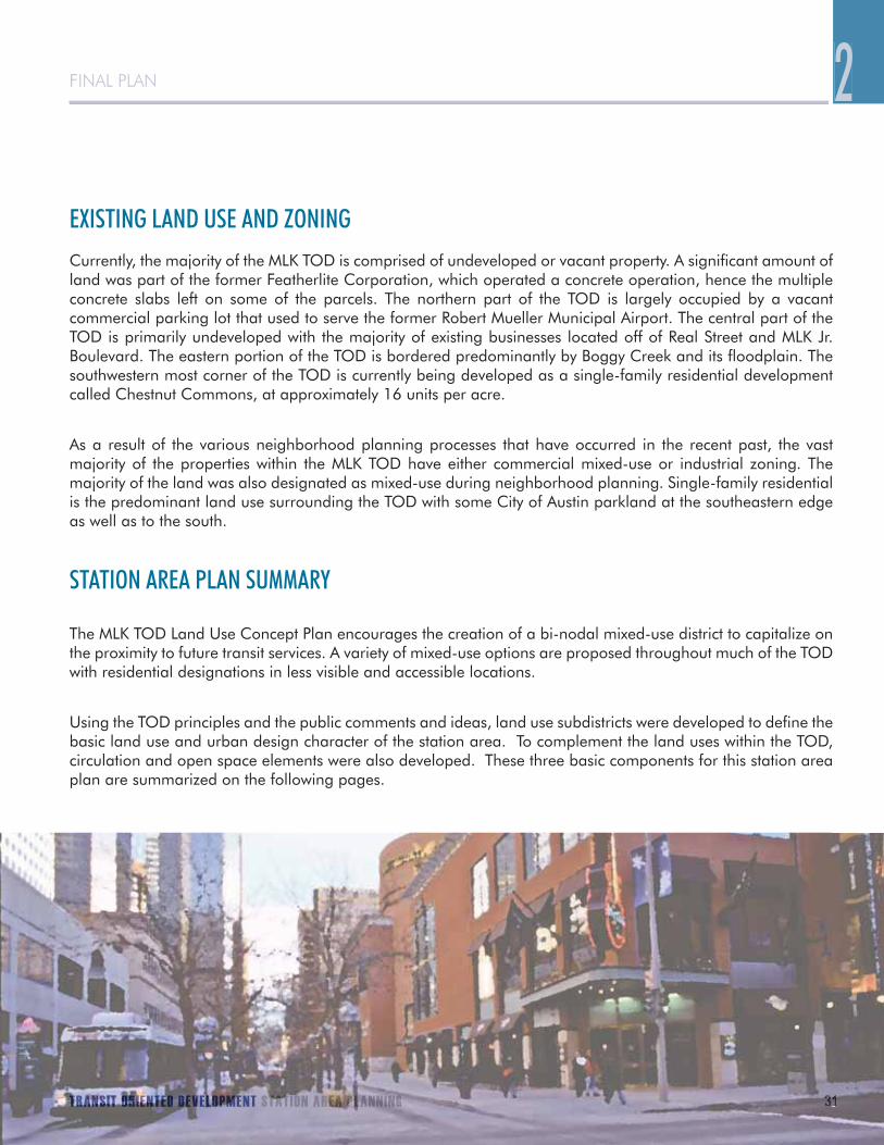
Images showing the existing area around the MLK TOD Station
FINAL PLAN
TRANSIT ORIENTED DEVELOPMENT STATION AREA PLANNING 31
FINAL PLAN
EXISTING LAND USE AND ZONINGCurrently, the majority of the MLK TOD is comprised of undeveloped or vacant property. A significant amount of land was part of the former Featherlite Corporation, which operated a concrete operation, hence the multiple concrete slabs left on some of the parcels. The northern part of the TOD is largely occupied by a vacant commercial parking lot that used to serve the former Robert Mueller Municipal Airport. The central part of the TOD is primarily undeveloped with the majority of existing businesses located off of Real Street and MLK Jr. Boulevard. The eastern portion of the TOD is bordered predominantly by Boggy Creek and its floodplain. The southwestern most corner of the TOD is currently being developed as a single-family residential development called Chestnut Commons, at approximately 16 units per acre.
As a result of the various neighborhood planning processes that have occurred in the recent past, the vast majority of the properties within the MLK TOD have either commercial mixed-use or industrial zoning. The majority of the land was also designated as mixed-use during neighborhood planning. Single-family residential is the predominant land use surrounding the TOD with some City of Austin parkland at the southeastern edge as well as to the south.
STATION AREA PLAN SUMMARY
The MLK TOD Land Use Concept Plan encourages the creation of a bi-nodal mixed-use district to capitalize on the proximity to future transit services. A variety of mixed-use options are proposed throughout much of the TOD with residential designations in less visible and accessible locations.
Using the TOD principles and the public comments and ideas, land use subdistricts were developed to define the basic land use and urban design character of the station area. To complement the land uses within the TOD, circulation and open space elements were also developed. These three basic components for this station area plan are summarized on the following pages.
2
TRTTRTRTRTTTTRTRTTTTTTTTTTTRTRTTTTTRTTTRTRTTTTTTTTTRTRTRTRTRTRTTTRTTRTTRTRRTRTTTRRANANANANANANANANANAANANANAANNANANAANANANANANNANANNANAANNANANAAANAANANAANANANANANAANNNANNANNANANANNNAANA SSSSISISISISISIIIISSSISSSIIISIISSSISIIIIISSSISISISSSISISSISISISSISIS TTTTTTTTTTTTTTTTTTTTTTTTTTTTTTTTTTTTTTTTT TTTTTT OROROOORORROROROROROROROROORRRORORRRORRRRRORORORRRRORORROORORORRORRORROROROROOOROROROROROROORRROOORRRRRRRRRRIEIEIEIEIEIEIEIEIEIEIEIEIIEIIIEIIIIEIIEEIIEIIEEIEIEEEIIEEEIEIEEEIIEIEIIIEIEIIIIIEIEEEEEIEEEEEEEEEEEIIEEEEEIEEEEIIIEEEEEEIEEIEIEEEIEENNNNTNTTTTTTTTTTTTTTTTTTTTTTNTNTTTTNTNTNTNTNTNNTTTNNNNNTNNNTNTNTNNNTNNTNNTNTNNNTTTTEEEDEDEDEDEDEEEEEEEEEEEEDEEEDEDEDEEEEEEDEEDEDEEEDDEEEDDDDDDDEDDE DDDDDDDDDDDDDDDDDDD DDDDDDEEEVEEVEVEVVVVVVVVVVVEEVEEVVEVEVEVVEVVVVVEVEEVVEVVEVVVVVVVVVVVVEVVVVVVVVVVVVVVVVVVVELELELELEEELLELLLLLLLLLELLLLLLLLLELLELLLELLLLLLLELELLEEELELLEEELLEEELELLLLLLLELEELLLLLOPOPOPOPOOPPOPOOPOPOPOPOOPOOOPOOOOOOOOOOOOOOOOOOOOPOPOOPPPOPPOOPOOOOOOO MMMMMMEMEMEMEMEMEMEMMEMMMMMMMMEMMMMMMMMMMMMMMMMMMMMMMMMMMMMMM NTNTNNTNTNT STSTSTSTTTTTTTTSTTTTTTSTTTTTTTTTTSTTSTSTATAATATATATATATATTTATATTATTTTTTAAAAAAAAAAAA IOIOIOIOIOOOOOIOIOIOOOONNNNN N AAARARARARRARRRRRRRRRRRRRARRRRRRRRREEEEAEAAAEEEAAAEAEEAEEEAEEAEEEAEAEEAEAEEAEEEEEEEEEEEEEEAEEEEEEEEEEEEAEEEEEEAEEEEEEEAEAEEEEAAEAA PPPPPPPPPPPPPPPPPPPPPPPPPPPPPPPPPPPPPPPPPPPPPPPPPPPPPPPPPPPPPPPPPPPPPPPPP PLLLLLLALALALLALLALLLLLLLALAAALALALLAALLLLAALLAALALALLLLLAAALL NNNNNNNNNNNNNNNNNNNNNNNNNNNNNNNNN ININININININIINNINININNIINIINI GGGGGGGGGGGGGGGGG 3131313133131111313313131313313131313131133313331331313131313
32 PB PLACEMAKING
Live/Work units Mid Rise Townhouses Mid-Rise Housing
1. LAND USE AND DESIGN CONCEPT PLAN
Land Use SubdistrictsThe Land Use and Design Concept plan consists of two types of zones – mixed-use and residential. Much of the land in the TOD district is designated mixed-use. The plan includes two commercial nodes: a primary mixed-use area along MLK Jr. Boulevard at Alexander Avenue and a secondary node along Manor Road to serve a potential future streetcar line. The plan envisions these mixed-use nodes and the Alexander Avenue corridor, which connects them, as being the most intensely developed with the highest density in the station area. The remaining portion of the station area is devoted to transitional uses of varying densities. The land use districts are summarized below:
Mixed-Use DesignationsThere are three types of mixed-use designations in the plan:• TOD Mixed-Use• Corridor Mixed-Use• Live/Work Flex
Residential DistrictsThe MLK station area includes residential zones in several locations. The rationale for residential development is to provide a better transition in specific locations with bordering single family residential areas and promote less development intensity in environmentally sensitive areas. In addition, the market will only support a relatively modest amount of commercial, and these areas do not have good street access or visibility. There are two types of residential designations in the plan:• Medium Density Residential• Low Density Residential
MLK JR. BLVD. TOD STATION AREA PLAN

FINAL PLAN
TRANSIT ORIENTED DEVELOPMENT STATION AREA PLANNING 33
FINAL PLANLAND USE AND DESIGN CONCEPT PLAN

34 PB PLACEMAKING
TOD Mixed-Use
TOD Mixed-Use is the most intensively developed land use zone and will typically be expressed as high density residential over active ground floor uses, such as retail or office. This land use designation is concentrated near transit stations and along major streets, generally located near the center of a TOD and along major ‘spines’ that lead to it. In this plan two commercial nodes are designated TOD Mixed-Use, and due to their high visibility and proximity to transit, they are the two most critical areas to the success of the station area. This land use designation is concentrated near the commuter rail stop south of MLK Jr. Boulevard and near the potential commuter rail/streetcar stop on Manor Road.
Corridor Mixed-Use
Corridor Mixed-Use allows a similar, but slightly more liberal, mix of uses as the TOD Mixed-Use district. Active ground floor uses or a mix of uses in one development are encouraged, but not required. Retail, office, and higher density residential development are all permitted. This zone is located on major streets farther away from the transit station.
Corridor Mixed-Use is located on Airport Blvd. at the intersection with both Manor Road and MLK Jr. Boulevard. This responds directly to the expressed public interest in pedestrian crossing safety improvements on Airport Boulevard. These intersections are also regarded as distinct “Gateway” locations for the TOD district, which should indicate that visitors and/or passers by are entering a special place.
Live/Work Flex
Live/work units are a type of mixed-use development, combining commercial, office, or light manufacturing space within the same structure as a residential living space for the business owner. They have similar benefits to mixed-use development and can eliminate the need to commute to work. In addition, they can provide affordable work and housing space, meet the needs of special groups, such as artists, and serve new incubator businesses. This district may serve as a transition zone between the higher density core uses and lower density neighborhoods. Depending upon the context, Live/Work Flex may be designed to either be primarily residential or commercial in character.
Live/work zones are located along the north side of Real Street and along a portion of Miriam Ave. In the context of this plan, this district acts as a transition zone between the higher density core and the surrounding low density residential neighborhoods, and as such, it should primarily be residential in character. Limited non-residential uses are allowed.
1. TOD Mixed Use Zones 2. Corridor Mixed Use Zones3. Live/Work Flex Zones
2
3
1
MLK JR. BLVD. TOD STATION AREA PLAN

FINAL PLAN
TRANSIT ORIENTED DEVELOPMENT STATION AREA PLANNING 35
FINAL PLAN
Example: Three or four stories of residential units (condos or apartments) above ground floor retail (cafes, coffee shops, boutiques).
Example: A small-format grocery store that is built up to the sidewalk with parking located behind the building.
Example: A three story rowhouse with the ground floor used as an artist studio and retail space.
TOD Mixed-Use
Corridor Mixed-Use
Live/Work Flex
2

36 PB PLACEMAKING
Medium Density ResidentialMedium Density Residential lies outside of the mixed-use areas (which are typically high residential atop retail), and the medium density designation provides a wide range for many housing types including attached row houses and apartment buildings. Commercial uses are not permitted in this zone.
A small Medium Density Residential zone is located on the south side of MLK Jr. Boulevard on the east side of Boggy Creek. It provides a transition between the higher density uses in the central portion of the station area and the low density neighborhoods nearby.
Low Density ResidentialLow Density Residential is considered ‘low’ in the context of a TOD station area, although it is ‘higher’ density compared to surrounding detached single family neighborhoods, which are typically around 7 units per acre in older Austin neighborhoods with detached single-family residences (assuming 6,000 square-foot lots). Commercial uses are not permitted in this zone.
A Low Density Residential zone is located south of E.17th Street and east of Miriam Avenue below the live/work zone where the Chestnut Commons residential development is being built. This area is removed from both activity nodes, and it is near existing single family neighborhoods. This low density residential zone provides an appropriate transition between the activity areas and the Chestnut neighborhood to the west.
Another Low Density Residential zone is located south of MLK Jr. Boulevard and east of the railroad tracks. This property was envisioned as open space in the Rosewood Neighborhood Plan and may be a concept supported by the property owner. Given the private ownership status of the land, an appropriate land use designation needs to be applied. This land is largely in 100-year floodplain and has access to a small residential street, E.16th Street, which makes Low Density Residential an appropriate category.
Planning for Families and SeniorsA desire was expressed by some charrette participants to provide senior and family housing within the MLK TOD. Future development can accommodate the needs of the elderly and households with children by thinking carefully about their space and recreational needs. Projects that provide a variety of unit types and sizes are more likely to attract a range of households from families to seniors wishing to live in a more urban environment. Open space should be provided to meet the needs of these different user groups. Projects that include day care services will potentially enable parents to walk to drop their children off or to use a day care close to work. The integration of residences, daily community services, and employment in a TOD, in addition to creating safe routes for pedestrians and cyclists, is essential to its success.
1. Medium Density Residential Zones2. Low Density Residential Zones
2
1
MLK JR. BLVD. TOD STATION AREA PLAN

FINAL PLAN
TRANSIT ORIENTED DEVELOPMENT STATION AREA PLANNING 37
FINAL PLAN
Example: A three story apartment building with surface parking.
Medium Density Residential
Low Density Residential
Example: Cottage-style detached homes with rear lot alley garages.
2

38 PB PLACEMAKING
MLK JR. BLVD. TOD STATION AREA PLAN
DENSITY AND BUILDING HEIGHTS An important characteristic of transit-oriented development is a residential density that is greater than the community average. The residential density of the existing single family neighborhoods around the MLK TOD district is approximately seven units per acre and somewhat higher densities in areas with multi-family housing. This Station Area Plan assumes a higher density than the surrounding average with the highest intensity proposed in the TOD Mixed Use Subdistrict.
The housing density of each of the land use zones includes a range with both minimum and maximum densities. The following table lists the density by land use zone.
HOUSING DENSITY BY LAND USE TYPELAND USE ZONE MINIMUM DENSITY MAXIMUM DENSITY
TOD Mixed-Use 2 stories 45 units per acre*Corridor Mixed-Use none 45 units per acre*Live/Work Flex 17 units per acre 45 units per acre*Medium Density Residential 17 units per acre 45 units per acreLow Density Residential 9 units per acre 16 units per acre
* Density limit may be removed in exchange for the provision of affordable housing
As a general rule, a 40-foot height limit permits a three-story building and a 60-foot building permits a five-story building. As a base height entitlement, the MLK Jr. TOD Station Area Plan assumes the existing height restrictions of 40 and 60 feet will continue throughout the district. The 40-foot limit generally applies to areas north of MLK Jr. Boulevard and the 60-foot limit generally to areas south of MLK Jr. Boulevard. There was a range of public opinion expressed with respect to appropriate allowable building heights. Generally speaking, three-to-five story buildings were supported throughout the TOD District. Input from the development community indicated that there was little interest in building heights greater than 60 feet as the cost of developing above that (e.g. steel-frame construction) is not financially feasible in this area today.
Minimum densities or building heights have been established in this Plan for certain land use subdistricts. This is an effort to respond to a key TOD principle - to create higher density within the Station Area than the surrounding community average to encourage a concentration of activity (residential and commercial) around transit to promote its use. As a result, minimum densities are included in the primary residential categories: Low Density Residential, Medium Density Residential, and Live/Work Flex. The TOD Mixed-Use Subdistrict contains a minimum height instead of a minimum residential density to enable a certain amount of flexibility in the type of activity that goes on in these locations, but at the same time, development must adhere to a certain level. A minimum height not only accommodates a traditional mixed-use development that includes both a residential and non-residential component, but also pure commercial and/or office development to support and stimulate employment opportunities and the provision of services within the TOD. Ultimately, the real estate market will determine what developers build within the Station Area as any project must have a market to support it and be financially feasible. The flexibility inherent in the TOD Mixed-Use Subdistrict is designed to respond to a variety of market conditions. The Corridor Mixed-Use Subdistrict contains neither a minimum density nor a minimum height as these areas are further removed from the core of the Station Area where the highest level of residential and commercial activity is intended.

FINAL PLAN
TRANSIT ORIENTED DEVELOPMENT STATION AREA PLANNING 39
BASE MAXIMUM BUILDING HEIGHTS
Note: Additional height may be allowed in the TOD Mixed-Use Subdistrict in exchange for the provision of affordable housing. Total building height of 60 feet may be allowed if current height limit is less.

40 PB PLACEMAKING
MLK JR. BLVD. TOD STATION AREA PLAN
This Station Area Plan recommends that in specific areas of the MLK TOD a density bonus, and in more select locations of the TOD a height bonus, be allowed in exchange for the provision of affordable housing. The intent is to promote denser, mixed income projects to locate in the land use subdistricts designated for higher density development and to encourage the highest levels of activity in areas with good access to transit. As a first step, the density bonus would remove density restrictions, without changing the allowable height, in exchange for a certain level of affordable housing. This type of bonus is allowed in the TOD Mixed-Use, Corridor Mixed-Use, and Live/Work Flex Subdistricts. In addition, a height bonus allowing total building height up to 60 feet is available within the TOD Mixed-Use Subdistrict for those properties that currently have a height limit less than 60 feet. The details of these bonuses and the required levels of affordable housing are established in the MLK TOD Regulating Plan.
1. Chestnut Commons. Austin, TX 2. Mixed-Use with affordable housing. Milwaukie, OR
3. Mixed-Use retail and residential. Fort Lauderdale, FL
1
2
3

FINAL PLAN
TRANSIT ORIENTED DEVELOPMENT STATION AREA PLANNING 41
FINAL PLAN 2AFFORDABLE HOUSINGAffordable housing is an important component of transit-oriented development. Inclusion of affordable housing in TOD areas can provide lower-income households with improved transportation access to employment and services. Reduced transportation costs can improve the ability of low-income families to afford housing payments. In addition, economic diversity among TOD residents will benefit transit ridership.
However, due to land prices and construction costs, new market-rate developments in the TOD areas are not likely to be affordable to low-income households. Citywide, the median home price of $180,000 is well above what is considered affordable for a low-income family. The average rent in Austin is $831, which is not affordable to households at or below 50% of Austin’s median family income1.
Housing GoalsTo promote the development of affordable units in TOD areas, the TOD Ordinance and TOD Housing Resolution include a goal that 25% of the new housing units in each TOD area should be affordable. The overall affordability goal is as follows:
Affordable owner-occupied units should be occupied by households with incomes at or below 80% of • Median Family Income (MFI) as defined by the U.S. Department of Housing and Urban Development, andAffordable rental units should be occupied by households at or below 60% MFI.• In addition, the Ordinance provides a specific breakdown of these targets.• 2
The TOD Ordinance establishes more ambitious goals for the two TOD areas located in the Community Preservation and Revitalization Zone (CP&R Zone) - the MLK and Plaza Saltillo TOD Districts. In these two TOD areas, the median income level of surrounding residents is typically lower than the citywide median. The affordability goals for these two districts are as follows:
Affordable owner-occupied units in the CP&R Zone should be occupied by households at or below 60% MFI; • andFor rental units in the CP&R Zone, the following goals apply:•
– 10% of the units should be occupied by households between 40-50% MFI;– 10% of the units should be occupied by households between 30-40% MFI; and– 5% of the units should be occupied by households below 30% MFI.
1 Sources: Austin Board of Realtors; ALN Apartment Data.
2 For homeownership units, a goal of providing 10% of the units to households with income from 70-80% MFI; 10% of the units to households with income of 60-70% MFI; and 5% of the units to households with income of not more than 60% MFI. For rental units, a goal of providing 10% of the units to households with income from 40-60% MFI, 10% of the units to households with income of 30-40% MFI; and 5% of the units to households with income of less than 30% MFI.

42 PB PLACEMAKING
Affordable Housing AnalysisThe TOD Ordinance includes a requirement that a Station Area Plan include a housing affordability analysis and feasibility review that describes potential strategies for achieving these goals. The Austin City Council selected the consulting firm Diana McIver and Associates (DMA) to conduct this analysis. DMA has provided several financial models for the achievement of the TOD goals, and has evaluated potential incentives and financing tools for creating housing affordability within the TOD areas; an executive summary of their report can be found in Chapter 3: Implementation.
DMA’s financial scenarios demonstrate that the achievement of the TOD affordability goals will be challenging and will require a substantial commitment of incentives and subsidies. While DMA has indicated that there is not one single solution to housing affordability in TOD areas, their analysis shows that a combination of tools can be used to achieve affordability in TOD districts.
MLK JR. BLVD. TOD STATION AREA PLAN
1. Community Preservation and Revitalization Zone (CP&R)
1

FINAL PLAN
TRANSIT ORIENTED DEVELOPMENT STATION AREA PLANNING 43
FINAL PLAN 2
URBAN DESIGN In addition to the land use districts, there are several important urban design treatments that should accompany land development in the station area. It is particularly important for development to be oriented to the street and pedestrians.
Roadway TypesUrban design elements are largely guided by three TOD street types – TOD Core Transit Corridor, TOD Pedestrian Priority Street, and TOD Local Street. This is modeled after the approach used in Subchapter E: Design Standards and Mixed Use, which categorizes all existing and future streets in the City, and then uses these designations as a basis for regulating streetscape, site, and building design. These three TOD street designations trigger specific streetscape and building design requirements within the Regulating Plan. The TOD Core Transit Corridors correspond to the existing and future Core Transit Corridors in Subchapter E. To address the unique issues related to the TOD station planning areas, two additional street designations apply. The three TOD street designations are described below and located in the Circulation Concept Plan:
TOD Core Transit Corridors. Citywide Core Transit Corridors are defined and listed in Subchapter E: Design Standards and Mixed Use of the Land Development Code. They correspond with many of the major city streets. A Core Transit Corridor within the boundary of the MLK TOD is labeled a TOD Core Transit Corridor, whose designation in this Plan was informed by the original Core Transit Corridors established in Subchapter E. In both this Station Area Plan and in Subchapter E, these Corridors indicate a roadway that has, or will have, sufficient population density and mix of uses to encourage and support transit use. TOD Core Transit Corridors are of primary importance as transit and pedestrian places, and therefore, it is essential to create vibrant, pedestrian-friendly places. In addition, design features must include buildings located adjacent to or near the street, parking to the rear or side of buildings, building facades and entrances that are oriented to the street, and amenities, such as shelter, plazas, and seating to create a pleasant environment. The TOD Core Transit Corridor Streets are Manor Road and MLK Jr. Boulevard.
1
1. Public gathering space2. Retail activity on street
2

44 PB PLACEMAKING
1
2
MLK JR. BLVD. TOD STATION AREA PLAN
TOD Pedestrian Priority Streets. This designation applies to specific existing or future streets within a TOD, which are especially significant as pedestrian routes. Pedestrian Priority Street designations are applied to critical pedestrian connections through the TOD and can provide direct access to transit. These streets complement the TOD Core Transit Corridors to form an interconnected pedestrian network. Because of their significance for pedestrian circulation, TOD Pedestrian Priority Streets are intended to have similar pedestrian facilities and amenities to the TOD Core Transit Corridors. Land uses are often less intense than those adjacent to TOD Core Transit Corridors, and requirements for locating buildings near the street are more flexible. However, proper building orientation to the street and parking lot screening continue to be important. Alexander Avenue and a portion of E. 17th Street are designated as TOD Pedestrian Priority streets because they provide direct connections to the mixed-use nodes and transit services at MLK Jr. Boulevard and Manor Road.
TOD Local Streets. These include all other existing or future streets within the TOD. While they are intended to provide comfortable, accessible, and pleasant accommodation for pedestrians, they do not represent the primary walking routes or pedestrian areas. Land uses are often less intense than those adjacent to TOD Core Transit Corridors and Pedestrian Priority Streets, and requirements for locating buildings near the street are more flexible. The remaining streets in the MLK TOD Station Area Plan are TOD Local Streets.
1. Urban residential street2. Quieter neighborhood street

FINAL PLAN
TRANSIT ORIENTED DEVELOPMENT STATION AREA PLANNING 45
FINAL PLAN
Active EdgesHaving a good pedestrian environment is a key element for important pedestrian and transit streets within the station area. Specific properties along these streets, which have a TOD Mixed-Use land use designation, are required to have active edges. This means that buildings must be next to the street and designed to accommodate retail, entertainment, and similarly active ground floor uses, which are directly accessible to the people walking by. Off-street surface parking may not abut active edge frontages, and driveways are only allowed when no other reasonable and sufficient access alternative is available. This activates the pedestrian zone, and it also improves safety by increasing the potential number of “eyes on the street” to deter crime and vandalism.
Two central locations surrounding the MLK/Alexander and Manor/Alexander intersections are the primary centers for the station area. As such, they are planned to have the highest density, greatest mix of uses, and a vibrant, urban character. While the design requirements summarized above will help shape such an environment, additional urban design standards are essential to establish them as urban centers.
Active edges apply to critical street frontages for properties within these two centers that are designated TOD Mixed-Use. Active edges are along portions of MLK Jr. Boulevard, the new extension of Alexander Avenue leading south to the station platform, and Manor Road. The active edge designation applies only to property design and development, and it does not affect adjoining public street and sidewalk design, which is determined by roadway type.
1. Mix of uses - office and retail 2. Active street3. Mix of uses - residential and retail
1
2
3
2

46 PB PLACEMAKING
GREEN BUILDING AND GREEN INFRASTRUCTURE
Green BuildingA primary goal of Transit-Oriented Development within the City of Austin is the promotion of development and re-development in a manner that will help absorb some of the region’s expected population growth in areas well-supported by transit. It is important that the development of the built environment involve goals favorable to achieving long-term sustainability. Achieving a sustainable future means meeting the needs of the present without compromising the needs of the future, and in doing so helping to make more live-able communities. Sustainability in Austin’s TOD areas involves taking active measures to protect against negative environmental impacts.
Recognizing the City of Austin has set specific goals in an effort to be a leader in green building, renewable energy, and sustainable technologies, this station area plan includes the following recommendations:
Recommendations
Improve air quality and public health by providing alternative 1. transportation choices. Provide clear alternatives to auto-centric development patterns by providing an environment that is pedestrian, bicycle, and transit-friendly.
Encourage all new buildings to meet the goals of the Austin Climate 2. Protection Plan in effect at the time they begin the permit process. Current goals are to make all new single-family homes zero net-energy capable by 2015 and increase energy efficiency in all other new construction by 75% by 2015. Zero net-energy capable means that a building provides enough energy efficiency that all of its energy needs could be accommodated by on-site energy sources such as roof-top solar panels. a. Reduce energy use of buildings through better design and choice
of materials and systems. Green buildings can achieve significant energy savings.- Buildings should have their longer sides oriented south as much as possible, and should minimize exposure to the west. As much as possible, minimize unshaded glazing on east and west exposures to reduce heat gain. Encourage glazing systems on northern and southern facades that reduce glare and provide opportunities for daylight harvesting (utilizing daylight to provide quality light indoors to minimize electric lighting). Overhangs, balconies, porches etc. should be utilized to provide shading of windows. - Buildings should be well insulated and use high efficiency heating and cooling systems. Systems should be sized and installed properly.
MLK JR. BLVD. TOD STATION AREA PLAN

FINAL PLAN
TRANSIT ORIENTED DEVELOPMENT STATION AREA PLANNING 47
FINAL PLAN 2b. Encourage distributed energy generation (solar/thermal, wind
power, etc.) within TODs and promote use of alternative energy sources through the Austin Energy Green Choices program.
3. Encourage roofing and paving design and materials that reduce the urban heat island effect (the tendency of urban areas to be several degrees warmer than the surrounding countryside). This includes using light colored roofing, siding and paving materials to reflect, rather than absorb the sun’s heat and by maximizing planted areas and shading paved areas and dark surfaces. Green roofs (planted vegetation on roofs) are a good option to help reduce the heat island effect and also provide air quality benefits.
4. Encourage protection of existing trees and plant new trees where possible. Trees should be considered part of the neighborhood’s infrastructure. Trees improve air quality by absorbing carbon dioxide and other harmful pollutants and to help reduce the urban heat island effect. a. Redevelopment should include a “street tree zone” to provide shade
between the street and sidewalk. Near powerlines, smaller trees which do not grow more than 25 feet should be planted. Trees can cool neighborhoods by three to six degrees if planted to shade areas that absorb heat such as streets, sidewalks and parking lots.
b. Trees should be planted in all parks and street medians.
5. Reduce solid waste production. Divert construction and demolition waste from the landfill to the fullest extent achievable and utilize existing infrastructure through adaptive reuse of buildings and building materials (developments in Austin have documented that more than 50% waste diversion is achievable). Design buildings to incorporate recycling collection areas and encourage tenants to recycle.
6. Promote the use of environmentally compatible building materials by selecting regional materials that are non-toxic, recycled and harvested in a sustainable manner.
7. Conserve water by installing low water use plumbing fixtures and appliances, using low water use native plants in landscaping, and utilizing rainwater harvesting, air conditioning condensate, or other recycled or non-potable water sources for irrigation.

48 PB PLACEMAKING
MLK JR. BLVD. TOD STATION AREA PLAN
Green InfrastructureGreen Infrastructure, when used in the context of stormwater management, uses smaller-scale decentralized treatment devices to mitigate the effects of urban development. Green Infrastructure often incorporates vegetation and landscaped areas into the treatment process, thereby allowing space to be used more effectively and aesthetically. Since they are individually smaller in scale, Green Infrastructure projects can be dispersed and integrated into the site and used to help meet landscaping requirements, allowing flexibility for water quality compliance for dense, urban projects. This contrasts with conventional “end-of-pipe” centralized controls which typically occupy a larger contiguous space and treat the entire developed area in one larger pond.
Recognizing that there are a limited number of TOD districts in Austin and that a central goal of TOD is to achieve dense, compact development, this plan supports the utilization of Green Infrastructure methods as a way to achieve both TOD and water quality goals. This plan encourages multiple uses of landscaped areas to maximize on-site storm water treatment, reduce needs for potable water irrigation of the landscape, and reduce reliance on traditional Best Management Practices (like storm water ponds) that decrease usable space. In order to reach these goals, development will comply with the regulatory strategy outlined in the Station Area Regulating Plan that combines newly adopted practices in the City of Austin Environmental Criteria Manual (ECM) with the Urban Watersheds Water Quality Fee-in-Lieu program and the Urban Watersheds Cost Recovery/Cost Participation Program.
Recently adopted criteria in ECM 1.6.7 provide direction on how to design vegetative filter strips, biofiltration ponds, rain gardens, porous pavement, rainwater harvesting and additional landscaping to meet Code-required water quality requirements per Section 25-8-213 of the Austin Land Development Code (LDC). These innovative controls rely on vegetative and landscape elements to treat storm water. The criteria specifically outline the standards for maintaining these native landscaped storm water controls in a sustainable manner (Refer to the Appendix for more information on specific Green Infrastructure methods).
Optimally, these controls will be integrated with landscaping areas already required of new development according to LDC Section 25-2-514 and Section 25-2 Divisions 2 and 3. This would reduce the need to construct a separate water quality facility; land that would have been used for separate water quality controls and landscaping is then available for other types of development. In addition, irrigation needs are minimized by having the ability to use storm water run-off to water plants and vegetation versus using potable City water. Specific Green Infrastructure requirements have been established in the Regulating Plan.

FINAL PLAN
TRANSIT ORIENTED DEVELOPMENT STATION AREA PLANNING 49
FINAL PLAN
INFRASTRUCTURE As part of the Station Area planning process, the conditions of the water, wastewater, and storm water systems in and around the MLK TOD were evaluated. Consultant Raymond Chan and Associates examined the water and wastewater systems and potential impacts to this system from future TOD development. The full report is provided in the Appendix. The water service for the MLK SAP is provided by a 24-inch water main in the north end of the Station Area, which supplies water to the remainder of the system. The overall capacity of the system is sufficient to serve additional development in the area, however, some improvement to distribution lines may be necessary to provide adequate water supply for both domestic use and fire protection.
The wastewater system also has sufficient overall capacity, which is provided by an interceptor system running parallel to, and east of, Boggy Creek. Some upgrading and improvement of secondary wastewater lines may be necessary to support specific redevelopment projects in the area.
The Watershed Protection and Development Review Department documented existing conditions of the storm water drainage system and identified potential future needs and methods for addressing flood, water quality, and erosion issues. This information is detailed in the Appendix.
2

50 PB PLACEMAKING
MLK JR. BLVD. TOD STATION AREA PLAN
Feasibility of MLK TOD Projects
Market prices, as identified by ERA a market research firm, are lower than in other station areas, and BAE’s estimates show that TOD is likely not financially feasible in the MLK station area at present. This is consistent with current market activity that is focused on various types of single-family development. At the same time, there are major land owners in the area whose cost of land may be considerably lower than what developers buying sites today would have to pay. This lower cost could make TOD projects viable on these sites. Investment in one or more catalyst projects could demonstrate market potential, and stimulate developer interest in other TOD, particularly as sales prices and rents rise in this area, and the Mueller redevelopment progresses.
FINANCIAL ANALYSIS
Timing of Projects & Financing Public Improvements
Bay Area Economics (BAE) was retained by the City to evaluate the financial feasibility of TOD and to provide a recommended financing strategy to help support this type of development in station areas. A summary of the BAE findings is presented in the following paragraphs, and the full reports are presented in the Appendix. In addition, several of the implementation techniques addressed in Chapter 3 reflect the BAE recommendations.
The timing of new development projects in the MLK SAP will be determined by the interaction of private sector market-based decisions with City decisions on public improvements and investments (along with zoning requirements) to set the stage for change. The factors shaping this interaction include:
Market Demand• – The level of market demand for various types of TOD, as well as the sale prices and lease rates for new development.Project Financial Feasibility• – Whether the cost of new TOD, including land, construction, parking, and financing allow developers to make a profit based on market sales prices and level of demand.Public Investment• – The timing and amount of public investments in new infrastructure, streetscape and open space improvements, as well as support for affordable housing and new TOD catalyst projects to attract and support widespread new private investment in TOD.
These factors are dynamic, meaning that they evolve over time, and the SAP needs to be flexible to respond to continuing change. Market conditions go through cycles, affecting the feasibility of uses and projects at any particular time. Success with new TOD in an unproven area can greatly increase other developers’ interest in building TOD. Public investment, while essential, is always a challenge because of limited resources, and its timing is not necessarily tied to market cycles.
BAE evaluated the financial feasibility of various TOD projects to identify those that are feasible today, versus those that will likely await improvement in market conditions. The estimates also identified the financing needs for catalyst projects that have the potential to shift market conditions and attract other new development.
Based on the public investment needs for infrastructure, streetscape and open space improvements, affordable housing, as well as funding assistance for potential catalyst projects, BAE reviewed existing public finance tools and formulated new approaches to create a TOD financing strategy for making the necessary public investments.

FINAL PLAN
TRANSIT ORIENTED DEVELOPMENT STATION AREA PLANNING 51
FINAL PLAN 2Enhancing the Feasibility of TOD Projects
TOD projects have higher construction costs than less dense projects, and a planning objective to create them in locations with moderate market conditions may require support to offset these higher costs. There are various public actions that can be taken to enhance the feasibility of TOD projects, including:
Create Parking Districts or other solutions to more efficiently share high-cost structured parking.• Assemble development sites and sell or lease them at a discount to developers.• Assist catalyst TOD projects, including those to create more affordable housing, through support for • infrastructure costs, parking, or modifications of planning requirements to enhance project revenues.Build denser TODs, which provide affordable housing, in order to stimulate developer interest in creating • other mixed-income and market-rate residential TOD projects.
Public Financing Strategy
Depending on the extent of new TOD, the value of various types of public investment in the MLK TOD Station Area along with Plaza Saltillo and Lamar Station Areas could range from $900 million to $1.6 billion or more. This level of new development would primarily be financed by private investment and would create substantial economic benefits, including new employment and property tax and other revenue for the City. However, public investment will be needed for infrastructure, streetscape and open space improvements, affordable housing, and catalyst projects to attract and support substantial levels of new private investment and realize the goals of the SAP.
The recommended financing strategy for public investment is a multi-layered one that uses new financing sources to capture the value of new development, new grant and fee funding sources, along with existing City programs and incentives. Key objectives for the public financing strategy include:
Phased implementation of the SAP to match public investment to market interest and targeted • opportunities;Minimal use of City General Fund or Capital Improvement Program funds to reduce competition with other • priority projects;Shift public improvement costs, to the greatest extent possible, to new development projects; and• Use all existing public finance tools authorized by law.•
The largest potential source of funds would be through use of Tax Increment Finance (TIF), which uses the increase in property taxes resulting from new development to cover the costs of public improvements. TIF does not increase taxes for existing property owners. For the SAP, it is recommended that only a portion of available tax increment be used, with the remainder available for new public services and schools to support residents and businesses occupying new TOD.
Other potential public finance sources include use of a combination of: Homestead Preservation Districts; Developer Impact Fees; Austin Housing Finance Corporation programs for affordable housing; Federal and State grants; and Public Improvement Districts.
There is a range of issues that must be addressed in a future Financing Implementation Plan. The Plan would be created as more detailed development plans are prepared and total public financing needs can be estimated and matched with potential sources. The Plan should provide for a wide range of creative public/private partnerships to stimulate TOD projects, utilizing existing City departments as well as new staff resources.

52 PB PLACEMAKING
2. CIRCULATION CONCEPT PLANSuccessful and functional community centers and transit service both rely on pedestrian environments that are safe, convenient with short walking distances, and have comfortable and stimulating surroundings. In addition to the design of development adjacent to the street (as noted above), this environment is also shaped by the design of the public realm, including public streets, sidewalks, and gathering places.
TOD streetscapes serve as walkable corridors that concurrently facilitate multi-modal transportation, including rail and bus travel, private auto traffic, walking, and bicycling. Where existing street design often regards roadways as simple conduits for the efficient movement of cars, station area streets are refocused on the need to provide a sense of place and pleasant environments for people. The Circulation Concept Plan is intended to complement the Land Use and Design Concept Plan by providing pleasant and convenient walking facilities, appropriate on-street parking, and amenities within the public street right-of-way and public places, such as street trees, landscaping, and plazas.
Multi-modal ConnectivityAn important objective of the station area plan is to create an integrated circulation system, which connects the “hole in the donut” with the surrounding neighborhoods by extending the street grid through the site where possible or by creating pedestrian connections when public street extensions are not feasible. The Circulation Concept Plan illustrates how these connections could be made and where to direct public and private resources to implement streetscape improvements and designate priority bicycle and pedestrian routes.
Walking rates are always higher when block sizes are smaller and connections between destinations are more numerous. The circulation concept indicates the types of new connections that should be made to enhance vehicle, transit, pedestrian, and bicycle circulation throughout the area, but there are undoubtedly several alternatives by which this goal could be achieved. Potential new streets, trails, and pedestrian connections shown on the Circulation Concept Plan do not indicate that they must be built in that exact location or alignment. While new streets must be integrated with the existing street network, blocks are generally intended to be less than 660 feet per side, and where possible smaller block sizes are encouraged.
For large sites, an interconnected street network must be created, but depending on individual site conditions and constraints, the street alignment may deviate from what is depicted, as long as the block standards in the Regulating Plan are met. Similarly, the exact location of trails and pedestrian connections will not be known until development begins to occur and/or public projects are initiated. Some of the potential improvements in the Circulation Concept Plan represent projects that would most likely need to be implemented by the City as they may not be part of any particular private development project. This plan does not imply that proposed streets will be publicly built and maintained. Certainly, public access must be protected to the transit station, and the City should strive for direct and convenient pedestrian connections, but this could be done with a private street network and public easements.
MLK JR. BLVD. TOD STATION AREA PLAN

FINAL PLAN
TRANSIT ORIENTED DEVELOPMENT STATION AREA PLANNING 53
FINAL PLAN
22CIRCULATION CONCEPT PLAN

54 PB PLACEMAKING
Pedestrian and Bicycle AccessThe MLK TOD is divided by the rail line and Boggy Creek, creating two significant obstacles for residents east of the station and south of MLK, Jr. Boulevard to reach the western portion of the MLK TOD, including the MetroRail station. In addition, a row of single family lots abuts the creek, which presents a significant obstacle to improve pedestrian and cyclist connections through the area. To address this issue, Circulation Concept Plan identifies a number of important improvements to create safe and convenient connections for walkers and cyclists. In addition, the adopted Austin Bicycle Plan recommends bicycle facilities on MLK Jr. Boulevard, and bike lanes have been provided on Manor Road. Consistent with the Austin Bicycle Plan and the special needs throughout the station area, the following improvements are identified:
A multi-use path link at the southwest corner of Pannell Place to provide direct access for neighborhood • residents to the rail station and MLK Jr. Boulevard. One option for providing this access would involve City purchase of one property in the southwest corner of the neighborhood, removal of the home, and creation of a pedestrian path and possibly a pocket park for residents.An east-west multi-use crossing is proposed south of MLK Jr. Boulevard. This connection would cross the • tracks and span the creek with a pedestrian and bicycle bridge connecting the station with E. 16th Street. This access was a very popular idea at the charrette. Note: In order for such an extension to occur, an at-grade crossing of the rail line would need to be approved by Capital Metro. This would necessitate a study to determine the feasibility of this project.East-west bike lanes are currently present on Manor Road and E. 12th Street, and the plan recommends that • these be maintained. In addition, the plan recommends a bike facility along MLK Jr. Boulevard consistent with the Austin Bike Plan. This road is currently very inhospitable to cyclists, but provides a direct connection to the downtown area. A bike facility is recommended along Alexander Avenue to provide a very important connection between • Manor Road, MLK Jr. Boulevard, and the MetroRail station.Better, safer pedestrian connections need to be made along both MLK Jr. Boulevard and Manor Road, • which are consistent with the TOD Core Transit Corridor designation. The substandard or absent pedestrian facilities on these two streets was a major concern among participants at the charrettes. If the TOD is to be accessible throughout, improvements need to be made, such as raised crosswalks and pedestrian priority signals, to make it safe to traverse the TOD from north to south. Logical locations to begin these improvements are near the intersections of MLK Jr. Boulevard and Manor Road with Alexander Avenue.Residents voiced support for a non-motorized connection somewhere between Manor Road and MLK, Jr. • Boulevard and across the tracks to the multi-use path along Boggy Creek. A conceptual connection is
MLK JR. BLVD. TOD STATION AREA PLAN

FINAL PLAN
TRANSIT ORIENTED DEVELOPMENT STATION AREA PLANNING 55
FINAL PLAN
shown on the Redeemer Church property on the same axis as Real Street. On some streets recommended for a bicycle facility in this Plan, the street right-of-way will not be adequate • to accommodate a separate bike lane. In such cases, bike route signage and street markings, such as sharrows are recommended to indicate and reinforce that cars and bikes share the road.Pedestrian and bicyclist improvements across Airport Boulevard at the intersections with MLK Jr. Boulevard • and Manor Road were also highly desired by some charrette participants, which is why these corners are proposed to be added to the MLK TOD district. The intersections are unsafe and difficult to navigate because of minimal, or lacking, accommodation for walkers and bicyclists.
Finally, one additional pedestrian element is to improve overall access from the surrounding neighborhood to the TOD district. Charrette attendees stressed that improvements should not be limited to the TOD district and that sidewalk improvements should be made on local streets in the surrounding neighborhoods so that safe access to the TOD and MetroRail station is provided. As a starting point, the transportation section of the relevant neighborhood plan should be consulted as sidewalk priorities were designated at the time the neighborhood plan was created.
Sidewalk Standards Based on Roadway TypeAs described previously, there are three roadway types within the station area – TOD Core Transit Corridors, TOD Pedestrian Priority Streets, and TOD Local Streets. This Station Area Plan applies many of the street design standards (sidewalk widths, clear zones, parking zones, etc.) from Subchapter E: Design Standards and Mixed Use and tailors them to the TOD Core Transit Corridors, TOD Pedestrian Priority Streets, and TOD Local Streets designated in this Plan. These requirements call for sidewalk widths of 5 to 15 feet, street trees, and a certain level of building frontage brought up to the sidewalk. Specific requirements for each roadway type are provided in the Regulating Plan.
Streetscape PrototypesThe project team focused on providing street cross section prototypes for three streets, MLK Jr. Boulevard, Manor Road, and Alexander Avenue as examples of redesigned streets with enhanced streetscape improvements that are consistent with their designation as either a TOD Core Transit Corridor or TOD Pedestrian Priority street. The curb-to-curb widths vary according to the existing and anticipated traffic volumes, but they all share wide sidewalks and bicycle lanes. These are further described in Chapter 3.
2

56 PB PLACEMAKING
3. OPEN SPACE AND TRAILS CONCEPT PLANWell designed, accessible, and integrated open space and urban landscape systems are critical to the success of the station area plans. The higher density and compact character inherent of TOD calls for an open space approach that recognizes the importance of open space to TOD inhabitants, employees, and visitors and surrounding residents alike. TOD mixed-use and commercial uses should include: plazas and private open space, storm water gardens and landscapes, landscape methods to reduce urban heat island effects, water efficient landscapes, and on-site renewable energy systems, all conveniently accessible to pedestrians and bicyclists. Likewise, residential districts should be in close proximity to open space with pocket parks to serve the various open space needs at a local level. Depending on the TOD context and environmental conditions, a more significant, broader reaching open space element such as a community park, garden or trail network could be very appropriate.
The open spaces designated on the Open Space Concept Plan do not indicate the exact location, type or amount of open space that must be provided as part of a private development. Until development begins to occur and/or public projects are initiated, the exact details on type, location, and amount of open space cannot be defined. Depending on individual site conditions and constraints, open space may deviate from what is depicted in the Concept Plan. The City of Austin Parkland Dedication Ordinance ensures that all private residential projects required to submit a site plan contribute to park needs either on-site or by paying a fee into a parks fund. Some of the potential open space elements in the Concept Plan represent projects that would most likely need to be implemented by the City as they may not be part of any particular private development project.
Existing and Planned FacilitiesBoggy Creek represents the primary open space area in the MLK TOD. The flood plain provides good potential for a greenbelt connecting with the existing trail that runs alongside the ball fields near the southern edge of the planning area. Chestnut Park is located on the western edge of the planning area on Chestnut Avenue, and the Boggy Creek Trail and Greenbelt extend just south of the TOD. A ‘Rails with Trails’ route is under discussion, but its alignment has not yet been determined.
Bikeway over bridgeTransit street
MLK JR. BLVD. TOD STATION AREA PLAN

FINAL PLAN
TRANSIT ORIENTED DEVELOPMENT STATION AREA PLANNING 57
FINAL PLAN
65
OPEN SPACE AND TRAILS CONCEPT PLAN

58 PB PLACEMAKING
Open Space and Trails Concept
Overall StrategyIt is important to include parks and open space to compliment higher density development. In addition, green corridors and pedestrian-friendly streets should provide pleasant, convenient, and safe connections between neighborhoods, parks and open spaces, and transit. The MLK TOD Open Space and Trails Concept Plan supports the provision of pocket and linear parks and greenbelts to provide recreational amenities to existing and future residents. Those that are depicted on the Open Space and Trails Concept Plan are conceptual and are shown to illustrate the potential placement of green elements to soften the edges of the built environment, and in some cases, provide a visual connection to transit. Actual open space may be built in a different location, configuration, or size than depicted on the open space concept map. The open space concept is primarily intended to portray the approximate amount and location of open space with the understanding that the final location and design will be determined as redevelopment occurs. Because the amount of parks and open space is linked to the density of new residential development, the amount of required parkland dedication will vary, and the location will depend upon site conditions and constraints.
Boggy Creek Open Space and TrailsThe plan vision statement identifies the integration of the natural and the built environments as a key guiding principle of the MLK TOD Station Area Plan. This will be accomplished though an ambitious plan for the restoration and improvement of Boggy Creek and the flood plain. Boggy Creek is a potentially valuable resource for the MLK TOD area, which has not previously been realized as such. Currently, a source of flooding and other concerns, the creek is proposed to be an essential part of a plan that binds together neighborhoods and creates a significant armature for the transit line and development along its axis. The proposed improvements should be bound together with any future plans for flood control or other infrastructure development by the City of Austin.
Trails are desired along Boggy Creek as a local recreational amenity and as a connection to a broader trail network to complement the existing trail on the western edge of the Mabson-Downs Ballfields and south of E. 12th Street. The trail system should incorporate connections to the surrounding neighborhoods and to future development. Pedestrian and bicycle connections to Boggy Creek are included in the Station Area Plan. Manor Road and E. 12th Street currently have bicycle lanes that should be preserved, and they will also serve as connections to the trail system. There are many possibilities for trails in this area; the Open Space and Trails Concept Plan illustrates possible routes that they might take. The final location and design will be determined as trail projects are initiated and/or redevelopment occurs.
In concert with City of Austin efforts to reduce flooding in the area, the TOD plan for Boggy Creek includes regrading and creating “soft armored” banks that would be designed as a native landscape with riparian plantings. Additionally, a significant opportunity exists to create public gardens at the proposed transit station area for use by the surrounding neighborhoods. Such gardens could include space for production, creek storm water reclamation, and a possible point of sale for produce grown in the gardens. Other opportunities may also exist for transit connections between these gardens and schools or other neighborhoods on the rail line. As there are not many active recreational uses in the immediate area, there was also a desire expressed by some neighboring residents to see more active uses within this flood plain area like a volleyball park or perhaps a Frisbee golf course. During the development process, any proposed recreational use would be reviewed by the Parks and Recreation Department for consideration in the floodplain area.
Recently, Capital Metro hired a consultant to conduct a feasibility study for ‘Rails with Trails’ along its 32-mile commuter rail line from Leander to downtown Austin. The consultant produced a document that outlined where Capital Metro has substantial right-of-way for such a trail within its rail right-of-way, identified environmental
Active Plaza with fountain Articulated public spaceGateway PlazaShared paths Quiet trail through park Segregated bike and pedestrian trail
MLK JR. BLVD. TOD STATION AREA PLAN

FINAL PLAN
TRANSIT ORIENTED DEVELOPMENT STATION AREA PLANNING 59
FINAL PLAN
and other constraints to a trail in certain locations, and proposed potential alignments (both within rail right-of-way and on-street connections) that could be the focus of future ‘Rails with Trails’ implementation efforts. The trail would provide connections to all rail stations and adjacent and intersecting trails. The total cost without the purchase of rights-of-way or property easements is estimated to be $50-$60 million. Capital Metro is and will be looking for funding partners to help pay for the overall project, which could take up to 15 years to complete.
The ‘Rails with Trails’ concept was enthusiastically supported by charrette participants. The feasibility study indicates that Capital Metro does not own substantial right-of-way for a trail through much of the MLK TOD and in addition, there are constraints due to the presence of steep slopes adjacent to the rail line. As such, the MLK TOD Open Space and Trails Concept Plan identifies an on-street trail alignment along Alexander Avenue as proposed in the Capital Metro study. However, if trail easements were granted by private property owners along the rail line, it is possible that a trail adjacent to the rail line could be realized. It is important to note that the Boggy Creek Trail idea and the ‘Rails with Trails’ concept could are not mutually exclusive of each other. The community expressed a desire for both a natural trail system along the creek for mainly recreational purposes and also a multi-use “Rails with Trails” pathway generally along the rail line that could serve both recreational and functional transportation needs.
Pocket ParksA pocket park, with a minimum size of 0.5 acre should be located between Manor Road and MLK Jr. Boulevard. Ideally, it should be located along Alexander Avenue and west of the MetroRail tracks. This park location would provide safe and convenient access to the neighborhood north of MLK Jr. Boulevard, and it should be linked with the proposed “Rails with Trails” facility. This park is very important for the overall livability of this portion of the TOD because the MetroRail tracks and MLK Jr. Boulevard are barriers to the other recreation opportunities in the area.
A second pocket park should be provided on the south side of MLK Jr. Boulevard and west of Alexander Avenue. Such a facility would provide active recreation space to complement the largely passive open space anticipated in the Boggy Creek flood plain.
The location of the pocket parks may change as the development programs for individual properties are more specifically defined. However, these two parks should have the following attributes:
A minimum size of 0.5 acre;• Configuration and design for active recreation, especially for children; • andGood visual and walking connections with other public spaces. •
21. Boggy Creek Concept2. Active recreation for children3. Passive space in neighborhood park
1
2
3


CHAPTER 3IMPLEMENTATION
3

62 PB PLACEMAKING
IMPLEMENTATION
IMPLEMENTING THE MLK JR. BOULEVARD TOD STATION AREA PLAN
MAKING THE PLAN REALThe adoption of the MLK TOD Station Area Plan (SAP) will not automatically implement the Vision articulated in Chapter 2. It is the first of many coordinated steps, which will need to be made over several years. The implementation of this plan along with other transit-oriented developments surrounding the proposed Capital MetroRail stations is expected to support ridership on Capital MetroRail and take full advantage of this public transit investment and the development potential of the station area. Successful implementation of the plan will require a strong partnership between Capital Metro, the City, other government agencies, the private sector, and the community.
UNDERSTANDING THE MARKET
AssessmentTo better understand market trends, Capital Metro retained Economics Research Associates (ERA) to conduct an assessment of economic trends, land values, and real estate markets in the Austin area. This assessment also considered the transit-oriented development potential of three transit station locations including MLK, North Lamar/Justin, and Plaza Saltillo. An initial evaluation was completed in 2006, and an updated analysis was completed in 2007 to respond more fully to station area planning activities. Conducting a market assessment was an important step in creating the station area plan because it helped frame the planning discussion by focusing on possible development scenarios, which were plausible for the station area. It helps the public and the City understand how to focus their collective planning energies to create the positive change envisioned in the plan.
The assessment indicated that the regional economy was strong and was expected to remain so. A diverse employment base, talented labor pool, and quality of life in the region received much of the credit for the city’s prosperity and popularity.
Development Potential in the MLK Station Area The MLK station is located in a neighborhood consisting predominantly of single-family homes, small retail stores, a few industrial buildings, and open space areas. As part of its analysis, ERA identified the MLK station area’s strengths and opportunities along with challenges and constraints for transit-oriented development, which include:
Strengths & OpportunitiesLocation – • The station will be only two stops away from Downtown Austin on the commuter rail line. It is located within one mile of the University of Texas, providing an opportunity to capture much of the real estate demand generated from the university’s students, faculty and staff.Support from Developer Community –• Landowners of both of the large sites adjacent to the future rail station have expressed interest in transit-oriented development, including linkages to transit facilities, a mix of land uses, pedestrian-friendly design, and higher densities.Community support – • Adjacent neighborhoods are generally supportive of mixed-use zoning for the areas near the transit station.

FINAL PLAN
TRANSIT ORIENTED DEVELOPMENT STATION AREA PLANNING 63
FINAL PLAN
Size of sites –• The combined acreage of two primary development sites (41 acres) is large enough to create a functional transit-oriented community.Recent development activity• – New housing projects and housing rehabilitation activity in the neighborhood indicate that there is a lot of interest from young professionals, artists and entrepreneurs.Amenities• – Improvements to the creek and creating open space opportunities could greatly improve neighborhood quality.Ability to attract Austin’s “creative class”• – According to Richard Florida, who coined this term to describe a category of innovative and creative professionals in the New Economy, Austin has the second highest number of “creative class” workers in the country. These “creative” workers are demanding high-quality, urban-style housing throughout Austin, and prefer neighborhoods with nearby cultural and performing arts venues. The proximity of popular venues like Arts on Real and the Dobie Theater give the Martin Luther King, Jr. station an advantage in attracting these types of residents.
Challenges & ConstraintsDue to the high number of retired seniors and college students in the area, the neighborhood’s median • household income is 50 percent of the metropolitan area median.There is currently a lack of amenities and nearby services.• Historically, the area has not had a positive image for development.• There is a lack of connectivity from neighborhoods to the northeast. Potential residents in those areas must • drive onto Airport Boulevard and MLK Jr.Boulevard in order to use the retail around the transit stationPotential for opposition from existing residents fearing gentrification or high-density development.Certain areas around Boggy Creek flood during periods of high rain. Development must be situated in such • a way to assure future homeowners and businesses that their property will not experience extensive damage during the rainy season.
Development ProgramBased upon the regional economy and the characteristics of the MLK station area, the ERA analysis yielded a summary of its development potential.
MLK STATION AREA DEVELOPMENT POTENTIAL SUMMARY 2007 TO 2025LAND USE LOW HIGH
Residential Condominiums, Flats & Live/Work Lofts 434 537Apartments 193 401Townhomes & Duplexes 287 500
Total Units 914 1,438Office Space (sq.ft.) 30,300 93,500Retail Space (sq.ft.) 52,630 93,500Hotel (units) 0 96
3

64 PB PLACEMAKING
IMPLEMENTING THE PLAN ELEMENTS Creating a TOD plan for the MLK station area is the starting point for realizing the Vision expressed by the public. Experience from successful planning programs consistently demonstrates the importance of strong partnerships between all levels of government, the transit agency, the private sector, and the community. Working together helps bring about quality development and strong neighborhoods. In addition, the ERA findings and other market information will be important to acknowledge as the implementation work moves forward.
I. Form a TOD Working GroupThe City of Austin should consider forming a “Working Group” including various city departments, Capital Metro, neighborhood representatives, and key members of the private sector. The working group’s primary focus should be to span jurisdictional and agency boundaries to facilitate collaboration and guide the implementation of transit-oriented development in the MLK TOD and other station areas along the Capital MetroRail line. Ideally, the members of the committee should have the authority to speak on behalf of their respective organizations and make decisions.
This group should meet regularly, with support from a technical committee of agency staff responsible for day-to-day management of the implementation strategy and individual tasks and projects. Other interests or subcommittees for individual station areas could also be included depending upon the desires of the participants. What is of the utmost importance is to have a focused and organized framework for implementing the plans for the station areas.
II. Prioritize and Implement Action ItemsThe first order of business for the working group should be to evaluate and identify specific action items for implementation, which are based upon the recommended projects and activities in this section. The recommended lists and descriptions represent the major activities and projects to undertake pertaining to:
• Planning and Administration• Transit-Oriented Development Catalyst Projects• Circulation and Streets• Open Space and Trails• Supporting Infrastructure
Recommended activities and projects are presented for each of the five facets of the implementation program noted above followed by a description of what should be done along with the lead party responsible for accomplishing the identified task. The recommendations are intended to provide a “checklist” of a series of tasks that will move the station area plan from concept to reality.
TOD catalyst project Beaverton,OR Mixed use boulevard street Open space with water feature
IMPLEMENTATION

FINAL PLAN
TRANSIT ORIENTED DEVELOPMENT STATION AREA PLANNING 65
FINAL PLAN
ACTION ITEMS
Planning and Administration
PA1 Adopt the MLK Jr. TOD Station Area Plan and MLK TOD Regulating Plan. Chapter 2 of this report constitutes the MLK Station Area Plan. The Vision and the key plan elements are all described and depicted on the plan maps for land use and design, circulation, and open space. These should be adopted along with the MLK TOD Station Area Regulating Plan. The Regulating Plan, which is an element of the overall Station Area Plan, will replace the current zoning in the station area and Subchapter E: Design Standards and Mixed-Use.
PA2-5 Amend affected Neighborhood Plans. Each neighborhood plan, which intersects with the MLK TOD, should be amended to include a TOD designation on the future land use map and make reference to the MLK TOD Station Area Plan as the most recently adopted plan and regulating strategy for the properties within the TOD.
PA6 Formation of a TOD Working Group. Formation of the Working Group described above will be a critical element for the plan’s success. Because implementation of the station area plan consistent with TOD design principles will require synchronized public agency and private sector actions, the development of strong working relationships, enhanced coordination, and community involvement will be essential. Many of the Plan’s activities and projects should be managed by this group to promote efficiency and timely progress on implementation.
PA7 Dedicated Staff. A city staff position should be created to work exclusively on implementation of the station area plans. Duties could include:
Informing property owners about the MLK TOD Station Area Plan, TOD zoning regulations, and opportunities • for redevelopment.Identifying property owners interested in redevelopment and facilitate information exchange between • property owners regarding such issues as property assembly.Pursuing funding opportunities for implementation of the Station Area Plan recommendations and • infrastructure improvements.Reviewing TOD projects that are seeking alternative equivalent compliance.• Reviewing and approving Project Circulation Plans.• Aiding Rails with Trails project implementation by proactively working with property owners to seek trail • easements in areas where the Capital Metro right-of-way is inadequate. Assisting property owners in providing affordable housing as part of their development and providing • funding information.Coordinate TOD Working Group•
PA8 Urban Design Division in the Development Review Process. Development review of TOD projects should include Urban Design Division staff to review and approve Project Circulation Plans and address any requests for alternative equivalent compliance.
PA9 Prioritization of TOD Projects. This Station Area Plan recommends prioritizing projects in and around the TOD on the General Obligation Bond CIP list, for grant funding, and/or for the potential establishment of special financing districts to respond to the higher level of development desired in the area. Sidewalk, bicycle and street/intersection improvements in and around the TOD are especially important to provide safe and efficient access to and through the area.
3

66 PB PLACEMAKING
PA10 TOD Financing Strategy and Tools. The plan for this station area is designed to leverage the CapMetro transit investment by encouraging supportive development surrounding the station. The benefits of TOD have been documented, however, creating successful TOD is not without significant challenges, which require public action and investment before the desired urban development may be realized. Bay Area Economics (BAE) provided a report, which describes TOD financial feasibility and financing strategies and tools that are the most promising for the Austin station areas. This evaluation is summarized in Chapter 2 and located in the Appendix. BAE advises that public investment will probably be necessary to stimulate the much larger investment expected by the private sector. Public attention regarding affordable housing, public infrastructure, and catalyst projects should be considered as outlined in the BAE memorandum. Several of the implementation actions in the following sections are included in response to the BAE recommendations. An important assignment for the Working Group will be to review the BAE information and recommendations to develop a financing strategy and set of supporting tools.
Financing elements recommended by BAE include:Adopt a phased implementation strategy for the TOD Plan that matches public investment to targeted • areas and market interest in new development;Minimize reliance upon City General Fund or Capital Improvement Program funds to reduce • competition with other priority projects;Make new development cover, to the extent feasible, a significant portion of the costs of public • capital improvements, including upgrades to water and wastewater systems; andUtilize all existing public finance tools as currently authorized by law.•
Specific public financing tools recommended in the BAE report to foster the implementation of TOD include:
Homestead Preservation District• Tax Increment Finance (TIF) Bonds• Developer Impact Fees• Austin Housing Finance Corporation• Federal/State Grants• Public Improvement Districts•
PA11 Monitor Implementation Effectiveness. The Working Group should monitor the effectiveness of the implementation elements of this station area plan and recommend changes to them as appropriate. This could include amendments to the plan itself, amending the Regulating Plan to make it more effective, and the financing strategy and tools. A review should occur at least annually.
IMPLEMENTATION
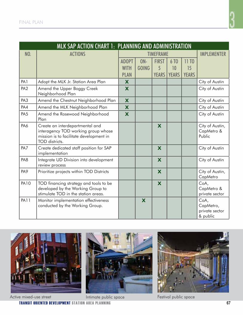
FINAL PLAN
TRANSIT ORIENTED DEVELOPMENT STATION AREA PLANNING 67
FINAL PLAN
MLK SAP ACTION CHART 1: PLANNING AND ADMINISTRATIONNO. ACTIONS TIMEFRAME IMPLEMENTER
ADOPTWITHPLAN
ON-GOING
FIRST 5
YEARS
6 TO 10
YEARS
11 TO 15
YEARSPA1 Adopt the MLK Jr. Station Area Plan X City of Austin
PA2 Amend the Upper Boggy Creek Neighborhood Plan
X City of Austin
PA3 Amend the Chestnut Neighborhood Plan X City of Austin
PA4 Amend the MLK Neighborhood Plan X City of Austin
PA5 Amend the Rosewood Neighborhood Plan
X City of Austin
PA6 Create an interdepartmental and interagency TOD working group whose mission is to facilitate development in TOD districts.
X City of Austin, CapMetro & Public
PA7 Create dedicated staff position for SAP implementation
X City of Austin
PA8 Integrate UD Division into development review process
X City of Austin
PA9 Prioritize projects within TOD Districts X City of Austin, CapMetro
PA10 TOD financing strategy and tools to be developed by the Working Group to stimulate TOD in the station areas.
X CoA, CapMetro & private sector
PA11 Monitor implementation effectiveness conducted by the Working Group.
X CoA, CapMetro, private sector & public
Active mixed-use street Intimate public space Festival public space
3

68 PB PLACEMAKING
Transit-Oriented Development Catalyst ProjectsTOD1 Catalyst Site Owners. The Working Group should establish a cooperative relationship with the owners of potential catalyst sites. The objective should be to identify how the parties can provide mutual assistance to initiate these critical first development projects. In particular, public assistance that would be beneficial to catalyst projects and the community generally should be identified and evaluated.
TOD2 Apply Finance Strategy and Tools. The Working Group should determine which specific financing strategy elements and tools (PA10 above) should be utilized to advance TOD catalyst projects with the goal of stimulating interest in overall TOD. This should be done with developers, property owners, and government agencies to develop the correct mix of incentives to promote TOD in the station areas.
TOD3 Create a TOD Catalyst Project. Developing a TOD pilot project will be an important way to create development interest in the station area. To the extent possible, such a project should include housing types not commonly found in Austin, but appropriate for the station area (such as higher density single family or mixed-use residential) and should include affordable housing. A catalyst project could also include the implementation of a key infrastructure or streetscape project, as described on subsequent pages.
MLK SAP ACTION CHART 2: TRANSIT ORIENTED DEVELOPMENTNO. ACTIONS TIMEFRAME IMPLEMENTER
ADOPTWITHPLAN
ON-GOING
FIRST 5
YEARS
6 TO 10
11 TO 15
YEARSTOD1 Meet with owners of catalyst sites. X Working
Group
TOD2 Apply finance strategy and tools for TOD implementation.
X CoA, CapMetro & private sector
TOD3 Create a TOD catalyst project. X Working Group & property owners
IMPLEMENTATION

FINAL PLAN
TRANSIT ORIENTED DEVELOPMENT STATION AREA PLANNING 69
FINAL PLAN
Circulation and StreetsCS1 MLK Jr. Boulevard Street Improvements.A street and streetscape project to improve safety, pedestrian and bicycle activity, and general neighborhood appearance will typically encourage private investment on adjoining properties. MLK Jr. Boulevard should be improved to create a positive change to the character of the street, encourage private investment, and enhance an important route that traverses the area. Because properties along the street will only redevelop over time, the only realistic way to create a meaningful change to the street’s appearance will be to sponsor an improvement for the entire street section within the station area.
MLK Jr. Boulevard is designated as a TOD Core Transit Corridor. Figure 3.1 illustrates a fully developed streetscape consistent with this designation, including the following elements:
Four travel lanes.• Center landscaped median/left turn lane at Alexander Avenue.• Bike lanes.• On-street parking, both sides of street, with designated bus loading areas to provide safe passenger • boarding.Minimum 15-foot wide sidewalk with a 7-foot clear zone.• Pedestrian crosswalk and signal location and design.• Street tree plantings at back-of-curb locations.• Plantings or moveable planters.• Street lighting.• Street furniture and other pedestrian amenities.•
Current right-of-way along this section of MLK Jr. Boulevard, which ranges from approximately 60 to 70 feet, is not sufficient to accommodate all of the suggested improvements below. Additional right-of-way or easements would need to be provided.
3
FIGURE 3.1 CROSS SECTION OF MLK JR BOULEVARD

70 PB PLACEMAKING
CS2 Parking and Traffic Management Strategy. The MLK station is designed for transit, pedestrian, bicycle, and kiss-and-ride access, but park-and-ride facilities will not be provided. Due to concerns that people will drive to the station and park in surrounding neighborhoods, a monitoring system to asses the parking situation should be implemented, possibly by the Working Group. If study determines that a problem exists, a management plan should be developed to address the situation. Such a plan should allow for local residents and visitors to park during the day, while discouraging commuters from parking on neighborhood streets. Likewise, concerns regarding cut-through traffic to adjacent neighborhoods should be monitored and improvements identified if a problem exists. Circulation system improvement projects noted in this section will complement these efforts by making walking and bicycling a more attractive option.
CS3 Alexander Avenue Street Improvements. Alexander Avenue should first be improved south of MLK Jr. Boulevard to become the primary route for all modes to and from the station. Second, this street should be improved between MLK Jr. Boulevard and Manor Road to provide improved neighborhood access to the MLK station while considering the proposed streetcar line and potential CapMetro station on Manor Road.
Alexander Avenue is designated as a TOD Pedestrian Priority Street. Figure 3.2 illustrates a fully developed streetscape consistent with this designation, including the following elements:• Two travel lanes.• Potential traffic calming techniques.• Bike lanes.• On-street parking, both sides of street.• Minimum 12-foot wide sidewalk with a 5-foot clear zone.• Pedestrian crosswalk location and design.• Street tree plantings at back-of-curb locations.• Plantings or moveable planters.• Street lighting.• Street furniture and other pedestrian amenities.
FIGURE 3.2 CROSS SECTION OF ALEXANDER STREET
IMPLEMENTATION

FINAL PLAN
TRANSIT ORIENTED DEVELOPMENT STATION AREA PLANNING 71
FINAL PLAN
CS4 Pannell Place Connection. Although the surrounding neighborhoods generally have interconnected streets systems, access to the MLK station from the Pannell Place neighborhood, east of Boggy Creek and north of MLK Jr. Boulevard, is constrained. A multi-use path connection to MLK Jr. Boulevard with access to Alexander Avenue and the station would provide safe and convenient pedestrian bicycle access to and from the neighborhoods to the east and north. The City should work with the neighborhood to identify potential route options, such as access easements or property purchase.
CS5 East-West Neighborhood Connection to Station Area. The neighborhood south of MLK Jr. Boulevard and east of Boggy Creek face similar access obstacles as the area to the north. A multi-use path connecting E. 16th Street and the station would provide safe and convenient pedestrian and bicycle access. In order for such a connection to occur, an at-grade pedestrian crossing of the rail line would need to be approved by Capital Metro. The Working Group should study this issue to determine what feasible alternatives exist.
CS6 Manor Road Street Improvements.A street and streetscape project to improve safety, pedestrian activity, and general neighborhood appearance will typically encourage private investment on adjoining properties. Manor Road should be improved to create a positive change to the character of the street, encourage private investment, and enhance an important route that traverses the MLK TOD and connects to key streets that lead to the core of the Station Area. In addition, as a potential future streetcar route, Manor Road presents significant opportunities to improve the environment from a functional and aesthetic perspective.3
Manor Road is designated as a TOD Core Transit Corridor.4 Figures 3.3 and 3.4 illustrate a fully developed streetscape consistent with this designation, including the following elements (current right-of-way along this section of Manor Road, which is approximately 60 feet, is not sufficient to accommodate all of the suggested improvements below, and additional right-of-way or easements will be necessary): • Two travel lanes.• Center landscaped median/left turn lane at Alexander Avenue.• Future streetcar in travel lanes.• Bike lanes outside of travel lane/streetcar rails.• On-street parking, both sides of street.• Minimum 15-foot wide sidewalk with a 7-foot clear zone.• Pedestrian crosswalk location and design.• Street tree plantings at back-of-curb locations.• Plantings or moveable planters.• Street lighting.• Street furniture and other pedestrian amenities
CS7 Manor Road Streetcar. Planning for the Manor Road streetcar should be completed in conjunction with the streetscape improvements contemplated in the MLK SAP. The design should accommodate pedestrian access along the street along with safe crossing opportunities. The alignment and platform location/design should accommodate bicycle travel in a right-side bicycle lane.
CS8 Capital MetroRail Station - Manor Road. This is recognized by Capital Metro as a potential additional station that could be built to facilitate more convenient passenger transfers between Capital MetroRail and the streetcar. The affect this could have on pedestrian access, crosswalks, traffic, etc. should be considered while action items CS6-7 are being developed.
3 If streetcar is implemented, on-street parking may be eliminated and the bike land merged with the auto lane at the station platform to allow traffic to bypass the stopped streetcar.4 While Manor Rd. west of Airport Blvd. is not longer an arterial in the CAMPO Plan, east of Airport is designated as a 4-lane major undivided roadway. If this concept is implemented, an amendment to the CAMPO Plan may be necessary.
3

72 PB PLACEMAKING
FIGURE 3.4 MANOR ROAD CROSS SECTION
FIGURE 3.3 INTERSECTION OF ALEXANDER AVE. & MANOR ST. VARIOUS CONFIGURATIONS OF CENTER PLATFORMS
Current right-of-way along this section of Manor Road, which is approximately 65 feet, is not sufficient to accommodate all of the suggested improvements below. Additional right-of-way or easements would need to be provided.
IMPLEMENTATION

FINAL PLAN
TRANSIT ORIENTED DEVELOPMENT STATION AREA PLANNING 73
FINAL PLAN
CS9 Continued Local Street System Improvements. The new TOD Local Street connections shown in the Circulation Concept Plan should be provided as development and redevelopment occurs. Several will be provided as the development of larger sites occurs (e.g., Featherlite, Redeemer Church, Airport Park). But others may necessitate public sector action, as in the case of improvements made to existing TOD Local Streets.
Figure 3.5 illustrates a fully developed streetscape, which is generally appropriate for the TOD Local Street Designation, including the following elements:• Adequate width for two-way travel.• On-street parking, both sides of street.• Minimum 5-foot wide sidewalk clear zone and 5-foot landscaped strip.• Optional curb-tight sidewalk with on-street parking.• Street tree plantings at back-of-curb locations or behind the sidewalk.
CS10 Airport Intersection Improvements. Because they represent entryways into the MLK TOD from the east, the Airport Boulevard intersections with Manor Road and MLK Jr. Boulevard should be improved to allow safe and convenient pedestrian travel through them. Sidewalk improvements, crosswalk enhancements, streetscape, traffic calming, and landscaping changes should be considered. Indicators at corners should signal to motorists, pedestrians and cyclists that they are passing through a “gateway”, and entering a more active urban environment.
CS11 TOD Projects as part of TIA Improvements. As part of the current evaluation of the Austin Traffic Impact Analysis (TIA) program, this plan recommends an amendment to Section 2.3.5 of the Transportation Criteria Manual, “Recommendation on Roadway Improvements and Traffic Control Modifications”, to allow for infrastructure projects (including bicycle, trail, pedestrian, and street/intersection improvements) in an adopted station area plan to qualify for required improvements through the TIA process.
INSERT TOD LOCAL STREET SECTION
3
FIGURE 3.5 TOD LOCAL STREET SECTION

74 PB PLACEMAKING
MLK SAP ACTION CHART 3: CIRCULATION AND STREETSNO. ACTIONS TIMEFRAME IMPLEMENTER
ADOPTWITHPLAN
ON-GOING
FIRST 5
YEARS
6 TO 10
YEARS
11 TO 15
YEARSCS1 Implement streetscape improvements on
MLK Jr. Boulevard X CoA & private
sectorCS2 Develop parking management strategy
to limit overflow parking on residential streets.
X Working Group
CS3 Implement streetscape improvements on Alexander Ave.
X X CoA, CapMetro & private sector
CS4 Create a pedestrian & bicycle connection from Pannell Place neighborhood to MLK Jr. Boulevard
X CoA
CS5 Create a pedestrian & bike connection from E. 16th Street to the station platform across Boggy Creek and railroad.
X CoA & CapMetro
CS6 Implement streetscape improvements to Manor Road
X CoA & private sector
CS7 Construct streetcar along Manor Road X CapMetro
CS8 Construct commuter rail station platform at Manor to provide transfer with streetcar.
X CapMetro
CS9 Continue to make local street improvements to better connect surrounding neighborhood to the TOD district.
X CoA & Private sector
CS10 Make improvements to Airport Blvd intersections with Manor and MLK
X CoA & TxDOT
CS11 Recommended amendment to the TCM to include projects in an adopted SAP
X CoA
Streetscape improvements Bike lanes Streetcar on main road
IMPLEMENTATION

FINAL PLAN
TRANSIT ORIENTED DEVELOPMENT STATION AREA PLANNING 75
FINAL PLAN
Open Space and TrailsOS1 Provision and Funding of Parks and Open Space. As part of this implementation program, the envisioned park and open space improvements are generally expected to be provided via existing parkland dedication requirements. Because open space is such an important element of compact, high density development areas, on-site open space provision generally in the form of pocket and/or linear parks, trails, and plazas are recommended. If it is either impossible or unrealistic that parkland be provided on-site, parkland dedication fees generated in a TOD are recommended to be spent within the TOD or in the immediate vicinity with the MLK TOD Station Area Plan used as a guide.
OS2 Boggy Creek Plan Refinement. Before the Boggy Creek open space vision can be realized, the current concept needs to be refined and further design analysis completed by the Parks and Recreation Department with involvement from the Watershed Protection Department.
OS3 Implementation of the Boggy Creek Plan. The Boggy Creek open space area should be improved according to the refined plan. This will be an important amenity that will become increasingly critical as the population in the station area grows.
OS4 ‘Rails with Trails’ Routes. In the MLK TOD, Capital Metro does not have sufficient rail right-of-way to accommodate a trail along the tracks. Implementation staff, and possibly the Working Group, should work with property owners to acquire easements for the future provision of a trail. In addition, this plan recommends that the feasibility of including Rails with Trails alignments in the Austin Metropolitan Area Transportation Plan be studied so that upon subdivision, land may required for the trail through the right-of-way dedication process. This work should also include the proposed pathway access linking the neighborhoods and the station.
OS5 Pocket Parks. The designated implementation staff person and the Parks and Recreation Department should work closely with station area property owners and developers to identify the location and design of the two pocket parks identified in this plan.
OS6 PARD Integration. Parks and Recreation Department (PARD) staff should be formally integrated into the development review process of all subdivision and site plan applications that fall within the boundaries of the MLK TOD so that open space opportunities may be analyzed and explored early on.
Neighborhood park Paseo or pedestrian street Park with pedestrian path
3
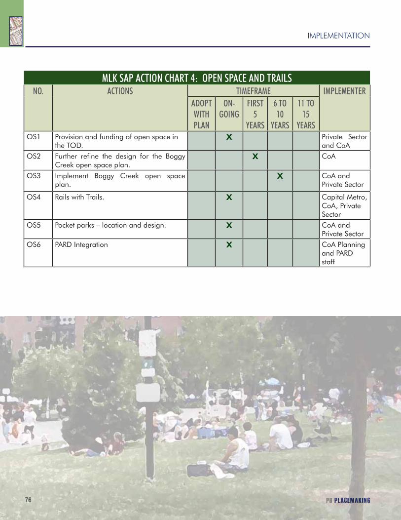
76 PB PLACEMAKING
MLK SAP ACTION CHART 4: OPEN SPACE AND TRAILSNO. ACTIONS TIMEFRAME IMPLEMENTER
ADOPTWITHPLAN
ON-GOING
FIRST 5
YEARS
6 TO 10
YEARS
11 TO 15
YEARSOS1 Provision and funding of open space in
the TOD.X Private Sector
and CoAOS2 Further refine the design for the Boggy
Creek open space plan.X CoA
OS3 Implement Boggy Creek open space plan.
X CoA and Private Sector
OS4 Rails with Trails. X Capital Metro, CoA, Private Sector
OS5 Pocket parks – location and design. X CoA and Private Sector
OS6 PARD Integration X CoA Planning and PARD staff
76767676776767 PBPBPBPPP PPLPLPPPLPLPLPLP ACACCCACACACACACACACACACCCCCCEEEEEEMEMMEEEEEEEEEMEEE AKKKIIININNNIIIINNI GG
IMPLEMENTATION

FINAL PLAN
TRANSIT ORIENTED DEVELOPMENT STATION AREA PLANNING 77
FINAL PLAN
INFRASTRUCTURE
3
I1 Comprehensive Utility Upgrades. Capital Improvement Projects (CIP) should be accomplished in a comprehensive manner that coordinates street reconstruction projects with other utility upgrades. A process should be established that examines all future public infrastructure needs when planning Capital Improvement Projects within and around the MLK TOD. An example would be replacement of undersized or old water or wastewater lines in conjunction with a street improvement project.
I2 Water System Improvements. To help stimulate development in the MLK station area, localized low pressure and/or low fire flow areas should be identified and prioritized for improvement to meet anticipated future demand.
I3 Wastewater System Improvements. To the extent possible, the Austin Clean Water Program (AWCP) should give high priority to wastewater improvements of strategic importance to enable development of key sites in the MLK station area.
MLK SAP ACTION CHART 5: INFRASTRUCTURENO. ACTIONS TIMEFRAME IMPLEMENTER
ADOPTWITHPLAN
ON-GOING
FIRST 5
YEARS
6 TO 10
11 TO 15
YEARSI1 Comprehensive utility upgrades X CoA
I2 Water system improvements. X CoA
I3 Wastewater system improvements. X CoA

3
78
IMPLEMENTATION
Diana McIver & Associates
AFFORDABLE HOUSINGAs part of the Station Area Planning process, consultant Diana McIver and Associates (DMA) prepared a report evaluating the feasibility of achieving the TOD affordable housing goals. The implementation items below are based on DMA’s final report (an executive summary of the report is on the following pages).
AH1 Encourage affordability via development bonuses.Development bonuses are an appropriate tool for encouraging the development of affordable units in TOD areas, while also encouraging transit-supporting density levels. Development bonuses with affordability requirements are recommended for waivers of both density and height requirements.
AH2 Provide gap financing with General Obligation Bonds and other sources.DMA has indicated that affordable housing developments located in TOD areas will require City subsidies in order to reach the TOD affordability goal, including those developments which utilize other public subsidies. The DMA Report has identified potential sources of gap financing that may be available to applicants on a case-by-case basis, which include City of Austin General Obligation (G.O.) bond funds. Projects within TODs submitting applications for G.O. bond funding should receive additional points as part of the scoring process.
AH3 Allow fees in-lieu of building on-site affordable housing in limited circumstances.
Allowing developers to pay a fee in-lieu of providing affordable housing on-site can be a useful tool in some instances, especially for non-residential projects that would like to take advantage of a development bonus. Any fee-in-lieu funds paid to fulfill an affordable housing requirement in a TOD development should be utilized for the financing or production of affordable units located within or near the TOD area.
AH4 Encourage and support Low Income Housing Tax Credit projects.DMA’s analysis indicates Low Income Housing Tax Credit developments would require the lowest level of City subsidy per unit and offer the most costs-effective use of public subsidies. A competitive tax credit proposal could substantially contribute to achievement of the affordability goals for a TOD area and would provide a large number of units near transit. This Plan recommends that the City of Austin provide gap financing for Tax Credit developments on a case-by-case basis.
AH5 Develop a catalyst project on City-owned property.City-owned property in the TODs may present an opportunity to realize the TOD vision on these sites and encourage similar development elsewhere in the TODs. This Plan recommends the City of Austin evaluate the potential for housing development on City-owned land within TOD Districts.
AH6 Provide a menu of incentives for projects that provide affordable housing.This Plan recommends that the City establish a package of incentives for TOD developments that provide affordable units on-site. The incentives could be scaled based on the level of affordability and the percentage of affordable units provided. Incentives could include development review fee waivers and an expedited review process beyond what is currently provided by the City’s S.M.A.R.T. Housing initiative.

TRANSIT ORIENTED DEVELOPMENT STATION AREA PLANS 79
3FINAL PLAN
MLK SAP Action Chart 6: AFFORDABLE HOUSINGNO. ACTIONS TIMEFRAME IMPLEMENTER
ADOPTWITH PLAN
ON-GOING
FIRST5
YEARS
6 TO10
YEARS
11 TO15
YEARSAH1 Encourage affordability via development bonuses. X COA
AH2 Provide gap financing with General Obligation Bonds and other sources.
X COA
AH3 Allow fees in-lieu of building on-site affordable housing in limited circumstances.
X COA
AH4 Encourage and support Low Income Housing Tax Credit projects.
X COA, Private and Public Sector
AH5 Develop a catalyst project on City-owned property. X COA
AH6 Provide a menu of incentives for projects that provide affordable housing.
X COA

3
80
IMPLEMENTATION
Diana McIver & Associates
TRANSIT-ORIENTED DEVELOPMENT (TOD) DISTRICTS STATION AREA PLANS
EXECUTIVE SUMMARY
INTRODUCTIONThe City of Austin’s Transit Oriented Development (TOD) Ordinance is intended to promote pedestrian-friendly, dense, mixed-use development surrounding the future commuter rail stations on the Capital MetroRail line. The TOD Ordinance, approved in May 2005, established six Transit Oriented Districts (TODs) and a Station Area Planning (SAP) process for the TODs, defined specific affordable housing goals for the TODS, and required an analysis of the feasibility of achieving the affordable housing goals.
The TOD Ordinance includes a goal that 25 percent of the new housing units in each Transit Oriented District should be affordable. For owner-occupied developments, the goal is for the affordable units to be sold to households with incomes at or below 80 percent of Median Family Income (MFI) . For rental developments, the goal is for the affordable units to be occupied by households at or below 60 percent of MFI. To be considered affordable, a homeownership or rental unit must serve a household at each of the corresponding income levels paying no more than 30 percent of its adjusted gross income toward housing costs, including utilities.
The TOD Ordinance also establishes goals targeting lower levels of affordability for Transit Oriented Districts located in the Community Preservation and Revitalization Zone (CP&R Zone). Table 1 below details the affordability goals of the TOD Ordinance.
TOD AFFORDABILITY GOALSTOD STATION OWNER-OCCUPIED RENTAL
General Affordability Goal 25% of new housing units affordableAffordable units at or below 80% MFI Affordable units at or below 60% MFI
CP&R Zone
(Plaza Saltillo and MLK)
Affordable units at or below 60% MFI Affordable units at or below 50% MFI5% units at or below 30% MFI10% units at or below 40% MFI10% units at or below 50% MFI
The affordability goals are ambitious. Due to significant development costs, land availability issues, legal limitations, development restrictions, and other challenges described below, there is a significant gap between the cost of developing rental and/or homeownership units and the income derived from either the rental or sale of those units to qualified low- and moderate-income residents.
This report identifies challenges to achieving the ambitious affordable housing goals specified in the TOD Ordinance, examines potential development scenarios, and provides recommendations for strategies to achieve the affordable housing goals. In order to achieve the goals, the City will need to implement multiple strategies which will require a significant amount of public subsidy and/or incentives. In addition, the City will need significant participation from external entities in order to create affordable housing in the TOD areas. Potential partners include affordable

TRANSIT ORIENTED DEVELOPMENT STATION AREA PLANS 81
3FINAL PLAN
housing developers and housing authorities, as well as the Texas Department of Housing and Community Affairs (TDHCA). Through a combination of incentives, funding sources, and other tools, the TOD affordability goals can be achieved.
TOD HOUSING POTENTIALAs part of the overall TOD planning effort, Economic Research Associates (ERA) provided market data and demand projections in the TOD Districts through the year 2025 (“ERA Station Area Market Analysis”). Assuming that the TOD Districts are built out to those full projections and that 25% of the residential units are designated affordable, DMA determined the following maximum potential yield for affordable housing in each of the three TOD Districts:
TOD DISTRICT ERA HOUSING POTENTIAL ESTIMATE THROUGH 2025(“HIGH” SCENARIO)
POTENTIAL AFFORDABLE HOUSING UNIT YIELD THROUGH 2025 (ASSUMES HOUSING GOALS ARE MET)
Plaza Saltillo 2,116 units 529 unitsMartin Luther King, Jr. Blvd. 1,521 units 380 unitsLamar Boulevard/Justin Lane 1,654 units 414 units
It should be noted that the above affordable unit yields are based solely on a calculation of 25% of the ERA Housing Potential Estimate. These figures are not intended to describe the financial feasibility of a particular number of affordable units.
IDENTIFICATION OF ISSUES
There are a variety of challenges to providing affordable housing within the Transit Oriented Districts. These issues include the following:
Legal Limitations – • The City has limited ability to compel the creation of affordable housing. State law limits the use of inclusionary zoning, which is a tool that requires inclusion of a certain percentage of affordable housing in new developments. This prohibition applies to homeownership units as well as to the use of rent control. Accordingly, an incentive-based approach is the primary strategy available to the City to compel developers to include affordable units in new developments.
Multiple Goals and Limited Resources – • There are multiple public goals for the Transit Oriented Districts, including increased development and higher density to support transit, affordable housing, open space, increased economic development opportunities, and high quality pedestrian improvements to create a walkable environment. All of these components are necessary for a successful TOD but can only be partially addressed by the private sector. Accordingly, there will be significant competition for limited public resources. Identification of available resources and clear definition of priorities will be crucial to the success of the TODs and the realization of the affordable housing goals.
3
82
IMPLEMENTATION
Diana McIver & Associates
Limited Public Land – • Offering public land for the development of affordable housing can be a powerful tool. However, there is a limited amount of publicly-owned land within the three TOD areas currently in the Station Area Planning process, and few of these publicly-owned properties are undeveloped. There are no publicly-owned sites within the MLK TOD.
Land and Construction Costs – • Both land costs and construction costs are high, making provision of affordable housing challenging. In particular, the cost associated with high-rise development (six stories and up) is significantly higher than mid-rise (five stories and below). In fact, the per-unit cost of mid-rise development is estimated to be approximately 60% of high-rise development. Because of this reality, height increases beyond a certain level have limited benefit for affordable housing.
TOD Ordinance Development Regulations and Restrictions – • The TOD Ordinance establishes height restrictions for the Saltillo and MLK TODs, thus limiting the tools available to achieve the goals of the ordinance. These restrictions make even modest increases in height difficult to achieve. It should also be noted that the community feedback received during the Station Area Planning process was not supportive of significant height increases.
Infrastructure Needs – • The first three TODs under consideration are located in central Austin, in older, established areas of the city. Much of the infrastructure, including water, wastewater, and storm water drainage, will require upgrades or replacement in order to support new development. Accordingly, the infrastructure needs will add development costs to affordable housing projects within the TODs.
IDENTIFICATION OF COSTS
In order to capture the true cost of affordability, DMA developed financial scenarios for both rental and homeownership developments in the three TOD areas. Utilizing current market data for a variety of factors, including mid-rise construction costs, land prices, and sales prices, DMA was able to identify the public subsidy required to make affordability feasible.
As a result of DMA’s financial analysis, it became apparent that every project (even those that were sponsored by nonprofit developers and included donated land and property tax exemption) would require some sort of public subsidy. Required per-unit subsidies for homeownership units ranged from $83,131 to $149,951 per unit, depending on the TOD. Required subsidies for rental units ranged from $75,870 per unit in the Lamar TOD to $127,623 per unit in the Saltillo and MLK TODs.
Even when a project is infused with tax credit equity (as in the 9% and 4% LIHTC with bonds models), there is additional subsidy required. For example, in order to make a rental project utilizing 4% tax credits and private-activity bonds financially feasible, the additional subsidy required would range from $41,350 to $56,800 per unit.
As discussed previously, high-rise development is significantly more expensive than mid-rise development. Public comments throughout the Station Area Planning process expressed desire to limit maximum height caps. Accordingly, DMA utilized cost data for mid-rise type development (two- to five-story) throughout its financial modeling.

TRANSIT ORIENTED DEVELOPMENT STATION AREA PLANS 83
3FINAL PLAN
Using cost data for the Saltillo TOD District, the following pie chart illustrates the cost of condominium development:
Plaza Saltillo Mid-Rise Condo DevelopmentCost Breakdown
$34,000 , 16%
$120,000 , 56%
$15,000 , 7%
$27,000 , 13%
$18,000 , 8%
Land
Hard Costs
Parking
Soft Costs
Developer
As demonstrated above, actual construction costs constitute the vast majority of development costs. In fact, hard costs, soft costs, and parking account for 86% of the total project costs. These costs would be the same whether the developer were for-profit or nonprofit. While nonprofit developers may have access to free or reduced-cost land, or may be able to limit their developer profit, they are still subject to the same market construction costs.
ANALYSIS OF DENSITY BONUS
A density bonus program allows a developer to increase the number of units that could be developed on a parcel of land in exchange for public benefit, such as affordable housing. The increased density would be the result of either relaxed development standards (e.g., Floor to Area Ratio, building coverage, and setback requirements, etc.) or height increase (e.g., above the current height restriction). A density bonus program is widely viewed as an important tool to achieve some portion of the TOD goals. However, there are a number of factors that must be taken into consideration in order to maximize the effectiveness of a density bonus program.
Construction costs per square foot rise with taller building heights, thereby limiting the benefit of incremental height increases. Mid-rise development utilizes lightweight steel or stick (e.g., wood) structural systems. High-rise developments require significant investment in elevators and core components, fireproofing, and multi-level structured parking, all of which contribute to increased development costs.
In addition, concerns regarding density and compatibility with surrounding neighborhoods were expressed in public meetings held during the Station Area Planning process. Although some participants in the Station Area Planning process voiced support for increased density (including height bonuses in exchange for affordable units), many participants were concerned with increased regarding density, especially as related to height. Several Saltillo participants were concerned about the neighborhood becoming too urban and densely developed. In addition, several participants in the Lamar Station Area Plan presentation were adamant about limiting density, with maximum TOD development height of two or three stories.
In order to reach the TOD Ordinance goal of 25% affordability in a new development, a density bonus would need to offer significant benefit to a developer. Only by doubling the density of a development (100% increase in FAR or height) and requiring that 50% of the bonus area be affordable, would a single development begin to meet the 25% affordability goal set in the TOD Ordinance.

3
84
IMPLEMENTATION
Diana McIver & Associates
In order to incentivize developers to take advantage of the density bonus, the program must be calibrated to provide a developer with a net financial benefit (e.g., a sufficiently higher profit). A developer will lose revenue on the affordable units, so the benefit gained from the additional units must outweigh the loss.
Keeping in mind public concerns regarding density and height limitations, DMA modeled a theoretical mid-rise development, with and without a density bonus. The following table profiles a 100-unit market rate condominium development on a 2.5-acre site (without any density bonus) and that same development with a 25% density bonus. The cost and sales assumptions are based on market data from the Saltillo TOD District.
In the case of the 25% density bonus, the developer is granted relaxed FAR or additional height in exchange for 25% affordability in the additional (“bonus”) area.
100-UNIT DEVELOPMENT 25% DENSITY BONUS125-UNIT DEVELOPMENT
Market Rate Units 100 119Affordable Units 0 6Total Land Cost $3,702,600 $3,702,600Total Project Cost $19,039,350 $22,901,000Additional Cost n/a $3,861,650Market Rate Sales $22,324,500 $26,494,200Additional Sales n/a $4,169,700 (market rate)Affordable Sales (60% MFI) n/a $684,890Total Sales Less Cost $3,285,150 $4,278,090
In this scenario, the community gains six units of affordable housing, or 5% of the total new units built. The private developer increases his return on investment, and there is no additional public subsidy. The only “cost” to the public is the additional FAR or height granted.
Considering the ambitious TOD affordability goals, the six-unit gain in affordability is modest. Even if every new development within the TOD District took advantage of a density bonus, there would need to more than 6,000 new units within the Plaza Saltillo TOD to provide 300 affordable units (which represent 25% of the estimated market demand, according to the ERA Station Area Market Analysis). Clearly, the density bonus needs to be combined with additional tools in order to make a substantial impact on affordability.
It is important to note that the 125-unit density bonus example only includes 25% affordability in the bonus area, rather than 25% of the total area. As currently written, the TOD Ordinance prohibits any increase in residential building heights in the CP&R Zone over the current maximum heights unless 25% of the total development is affordable. In order to develop the same 2.5-acre site and incentivize affordability in at least 25% of the total units, the density bonus would need to be significant.
In the scenario below, the developer is granted a 100% density bonus (from 40 units per acre to 80 units per acre). Accordingly, the site now accommodates 200 units, 50 of which will be designated affordable (25% of the total units). The basic assumptions, including land cost and the development costs, remain the same as in the previous model.

TRANSIT ORIENTED DEVELOPMENT STATION AREA PLANS 85
3FINAL PLAN
100-UNIT DEVELOPMENT 100% DENSITY BONUS200-UNIT DEVELOPMENT25% TOTAL AFFORDABILITY
Market Rate Units 100 150Affordable Units 0 50Total Land Cost $3,702,600 $3,702,600Total Project Cost $19,039,350 $34,376,100Additional Cost n/a $15,336,750Market Rate Sales $22,324,500 $33,517,500Additional Sales n/a $11,193,000Affordable Sales (60% MFI) n/a $5,483,235Total Sales Less Cost $3,285,150 $4,624,635
In this scenario, the developer is sufficiently incentivized to develop a project that designates 25% of its units as affordable. However, there are limitations to the density and height bonus model. Development costs increase disproportionately once the building transitions from a mid-rise to a high-rise structure. In addition, increased risk accompanies the increased number of units. The developer has to market and sell the additional units (both market-rate and affordable) in order to realize the substantial return on investment. Considering the disproportionate costs associated with significant increases in density, as well as concerns voiced by neighboring residents, a two-tier density bonus program is recommended below.
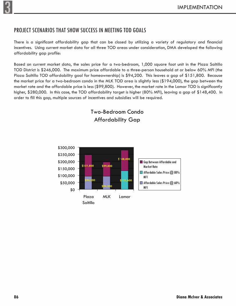
3
86
IMPLEMENTATION
Diana McIver & Associates
PROJECT SCENARIOS THAT SHOW SUCCESS IN MEETING TOD GOALS
There is a significant affordability gap that can be closed by utilizing a variety of regulatory and financial incentives. Using current market data for all three TOD areas under consideration, DMA developed the following affordability gap profile:
Based on current market data, the sales price for a two-bedroom, 1,000 square foot unit in the Plaza Saltillo TOD District is $246,000. The maximum price affordable to a three-person household at or below 60% MFI (the Plaza Saltillo TOD affordability goal for homeownership) is $94,200. This leaves a gap of $151,800. Because the market price for a two-bedroom condo in the MLK TOD area is slightly less ($194,000), the gap between the market rate and the affordable price is less ($99,800). However, the market rate in the Lamar TOD is significantly higher, $280,000. In this case, the TOD affordability target is higher (80% MFI), leaving a gap of $148,400. In order to fill this gap, multiple sources of incentives and subsidies will be required.
Two-Bedroom CondoAffordability Gap
$151,800
$94,200
$94,200 $131,600
$148,400
$99,800
$0
$50,000
$100,000
$150,000
$200,000
$250,000
$300,000
PlazaSaltillo
MLK Lamar
Gap Between Affordable andMarket Rate
Affordable Sales Price @ 80%MFI
Affordable Sales Price @ 60%MFI
tt

TRANSIT ORIENTED DEVELOPMENT STATION AREA PLANS 87
3FINAL PLAN
Homeownership ScenarioThe graph below illustrates the financial gap for the development of hypothetical owner-occupied, affordable condominium developments in the Saltillo, MLK, and Lamar TOD areas. This example shows the most likely sources of subsidy or assistance that could bridge the gap.
Bridging the Affordability Gap: $151,800 at Plaza Saltillo
Direct Public Subsidy$73,774
49%
Fee Reductions$1,000
1%
DownpaymentAssistance$40,000
26%
Land Value$37,026
24%
If the developer utilized the City’s S.M.A.R.T. Housing™ program, in addition to expedited plan review, the average per-unit fee reduction would be approximately $1,000 (in addition to financial benefits from expedited plan review). If the developer participated in a Community Land Trust model (or the City purchased the land and leased it to the developer at a nominal rate), that would represent additional savings, ranging from $18,513 to $37,026 per unit depending on the TOD area.
Even utilizing fee waivers and removing land costs, however, is not sufficient to reach even the upper range of the TOD affordability goals. In the examples above, the affordability gap is closed through a combination of fee reductions, elimination of land costs, waivers, and public subsidy, including City of Austin Down Payment Assistance and GO Bond funding.
It is important to note that any developer — nonprofit or for-profit — will face this affordability gap. While nonprofit developers are motivated by their mission to provide affordable housing and may have access to some funds that are not available to for-profit developers, they still have to pay to construct the units and oftentimes have to sell at fair market value.

3
88
IMPLEMENTATION
Diana McIver & Associates
Rental ScenarioAlthough the sources and uses in a rental model are slightly different, these developments also require significant subsidy. The following is an example of a rental development currently under construction one block from the Plaza Saltillo TOD. Guadalupe Neighborhood Development Corporation (GNDC) is the nonprofit sponsor of this 22-unit rental development.
Although the La Vista de Guadalupe project is not technically in the TOD district, the construction type and the density (44 units per acre) are similar to the type of building that would be appropriate in the TOD. The development is 100% affordable with very low rents. Approximately 30% of the units will have rents affordable to families at 30% MFI; 15% of the units will have rents affordable at 40% MFI; and 55% affordable at 50% MFI.
La Vista de Guadalupe
Development Sources per Unit
Land Donation, $29,545
Tax Credit Equity,
$142,127
City of Austin, $76,965
First Mortgage, $19,818
Developer's Contribution,
$15,668
0%
10%
20%
30%
40%
50%
60%
70%
80%
90%
100%
$284,000 per Unit
Developer's ContributionCity of Austin
First Mortgage
Tax Credit Equity
Land Donation
The largest source of funds for this development is the equity from Low Income Housing Tax Credits, but sev-eral other sources are critical to making the project work. The land for this development is valued at $650,000 (nearly $30,000/unit) but was donated to the project by the nonprofit sponsor. (GNDC purchased the land more than 20 years ago at a very low price.) Another important source of financing for this development is the de-veloper’s contribution of deferred fee. Although GNDC is earning a fee of $650,000, the developer must forgo $344,000 of the fee (identified as “Developer’s Contribution” in the bar chart) in order to make the project financially feasible. In addition, the City of Austin has committed almost $1.7 million, or $77,000 per unit, to this development.

TRANSIT ORIENTED DEVELOPMENT STATION AREA PLANS 89
3FINAL PLAN
The City can also participate directly in housing development through the Austin Housing Finance Corporation (AHFC). For example, in 2003 AHFC partnered with a private developer/builder to develop Villas on Sixth Street using Housing Tax Credits. Villas on Sixth Housing Associates, L.P. , the entity that owns the development, is a true partnership between public and private interests. AHFC created a new nonprofit corporation, Villas on Sixth Non Profit Corporation, to be the general partner of this limited partnership. The tax credits were sold to MMA Financial, and one of its entities is the limited partner. An entity of Campbell-Hogue’s, Campbell-Hogue Financial Services, LLC, owns a minority share of the project and acts as a guarantor, since the nonprofit cannot.
Owner
Villas on Sixth Housing Associates, L.P.
General Partner
Villas on Sixth Non Profit Corporation
Class B Limited Partner
Campbell-Hogue Financial Services, LLC
Austin Housing Finance Corporation
General Contractor
Campbell-Hogue & Assoc., Inc.
Land Owner
AHFC leases land to L.P.
Developer
CHA Development, L.P.
Limited Partner
MMA Financial
In addition to its role in the ownership, AHFC purchased the land for the development and leases is back to the partnership, which allows the property to be exempt from property taxes. Campbell-Hogue & Associates, Inc. was the general contractor who built the property, and its development arm, CHA Development, L.P., was the developer.
This creative partnership allowed the City to work with an experienced developer who knows and understand this type of development and the complicated financing mechanisms involved, while at the same time ensuring long-term affordability.

3
90
IMPLEMENTATION
Diana McIver & Associates
RECOMMENDATIONS
In order to achieve the affordability goals established in the TOD Ordinance, the City must utilize a multifaceted approach. In addition, the policies implemented to achieve housing affordability within the TOD areas should be reviewed and analyzed after a period of time to determine success in meeting affordability goals and to make recommendations for adjustments to the policies.
DMA recommends the following:
Recommendation #1: Implement Density and Height Bonus Program
DensityThe City Council has adopted a Vertical Mixed Use (VMU) density bonus with affordability requirements, as part of the Design Standards and Mixed Use ordinance. Although it is too early to determine the success of the VMU density bonus incentives, a similar strategy should be established for the TOD Districts, which are intended to have a mixed-use character similar to that envisioned for VMU developments.
To incentivize the development of affordable housing in the TOD Districts, the City should exempt properties from Floor-Area-Ratio (FAR), maximum densities, building coverage limits, and setback requirements, in exchange for 10% of the total residential square footage being designated affordable. As in the VMU Ordinance, the afford-ability period for owner-occupied units should be a minimum of 99 years and rental units should be 40 years. (It should be noted that this bonus does not include a height bonus. A height increase entails a different affordability requirement as discussed below.)
The calculation for the designated affordable units is based on habitable square footage, rather than number of units. For example, a 30,000 square foot project that receives an additional 15,000 square feet (due to FAR and other exemptions), will be required to set aside 10% of the total square footage (10% of 45,000 square feet or 4,500 square feet) for affordable units.
There are multiple reasons for calculating based on habitable square footage versus number of units. The square footage requirement gives the developer greater flexibility in determining the allocation of unit sizes and thus enables the developer to better respond to market needs. If the requirement is calculated based on number of units, the result will most likely be smaller one-bedroom units. However, if the developer is given the freedom to apportion unit mixes (and is simply required to make a certain total square footage affordable), there is greater likelihood that family units will be incorporated into the unit mix.
Since the density bonus will offer a similar benefit as that offer in the VMU Ordinance, the income limits on the affordable units should also be the same—a maximum of 80% MFI for homeownership units and 60% for rental units. In order to reach the affordability targets set in the TOD Ordinance; however, the City will need to employ additional incentives or subsidies.
In order to “buy down” the affordability of a unit (e.g., reduce the affordability level from 80% MFI to 70% MFI), it is estimated that the present value cost is $25,000 per 10% increment. Accordingly, each 10% incremental reduction in MFI will cost $25,000 per unit in subsidy to offset the lost income to a developer. The TOD afford-ability goals are more ambitious than the VMU goals. Therefore, the density bonus alone is insufficient to incentive a developer to incorporate affordable units into a residential project.

TRANSIT ORIENTED DEVELOPMENT STATION AREA PLANS 91
3FINAL PLAN
Because the density bonus alone will not achieve the affordability targets, the approach will need to be coupled with additional incentives and public subsidies. As in the case with VMU policy, the City must have the option to subsidize additional affordable units within the development. The effectiveness of this density bonus and its af-fordability requirements should be reviewed within one year of implementation.
DMA recommends that density bonuses be available to any type of development within the TOD Districts, including residential, non-residential, and mixed-use. In the case of projects that utilize the bonus but do not include residen-tial units, the developer would be required to pay a fee-in-lieu (rather than develop on-site affordable units) as described further below.
HeightDMA recommends that the City of Austin institute a height bonus to achieve up to a total building height of 60 feet in the TOD Mixed Use Subdistrict of the Lamar, Saltillo, and MLK TODs. Only those properties that currently have a height entitlement of less than 60 feet are eligible for the height bonus. In order to access the height bonus, a developer would need to commit to 25% affordability of the bonus area (square footage) to be reserved for households meeting the affordability goals established for each TOD (or for development that does not contain residential units, the relevant fee-in-lieu must be paid). As an example, a developer seeking additional height equal to 100,000 square feet would need to provide affordable units within the development totaling 25,000 square feet. Again, as discussed above, the calculation is based on habitable square footage, rather than number of units.
Because of community concerns related to compatibility and due to limited financial benefit accompanying density bonuses with affordability requirements in high-rise construction, DMA recommends that height bonuses should be limited to mid-rise heights. Throughout most of the three TOD Districts, current zoning restricts development to 40 or 60 feet. As discussed previously, a height bonus from five stories to six- or more stories may have limited value be-cause of the corresponding increase in costs between mid-rise and high-rise development. In addition, because of neighborhood concerns regarding compatibility with surrounding single-family neighborhoods, significant increases in height are not broadly supported. The City’s approach to height bonuses should focus any additional height entitlements in defined locations around the transit stops where the highest densities are appropriate.
In certain cases, a developer may request both the density bonus and the height bonus. In this situation, the project would need to include 10% affordability in the total project (pre- height increase), as well as an additional 25% affordability in the bonus height area.
Currently, the TOD Ordinance limits the City’s ability to increase heights in the part of the Saltillo TOD that is desig-nated as TOD Mixed Use but falls outside of the 11-acre Capital Metro property. In addition, the TOD Ordinance requires stringent affordability requirements for a height bonus in the CP&R Zone. Specifically, the TOD Ordinance requires that 25% of the total development meet affordability targets (rather than 25% of the bonus area, as DMA recommends). Accordingly, in order to implement DMA’s height bonus recommendations, the TOD Ordinance will need to be amended.
Fee-In-LieuDMA recommends a fee-in-lieu payment in the amount of $10 per square foot of additional benefit. This amount conforms to the fee-in-lieu recommendation of the Affordable Housing Incentive Task Force and the amount recom-mended to the City Council during the process of adopting a downtown density bonus ordinance. The fee-in-lieu amount should be reviewed and adjusted annually. Any funds captured through the fee-in-lieu program should be

3
92
IMPLEMENTATION
Diana McIver & Associates
utilized for affordable housing within the TOD Districts.
Typically, a fee-in-lieu option is offered to residential developers who opt to not provide on-site affordable units, or to developers of commercial properties. The fee-in-lieu for the TODs should be required of commercial devel-opments that utilize a height bonus and/or density bonus, as well as to residential or mixed-use developments on a more limited basis.
Because the intent of the TOD Ordinance is to develop affordable housing within the TOD Districts and those districts are relatively small, residential developers should be encouraged to develop on-site affordable units. A residential developer seeking fee-in-lieu should have a compelling economic basis for not providing on-site afford-able units. A compelling reason might include that the funds will be directed to a stand-alone 100% affordable development in the TOD District.
Recommendation #2: Encourage HTC Developments and Dedicate Appropriate Resources
Based strictly on financial realities, the most cost-effective use of public subsidies is the traditional Housing Tax Credit (HTC) development. According to DMA’s financial models, the public subsidy required for a 4% tax credit with private activity bonds project is estimated to be $56,800 per unit. In this scenario, 100% of the units would be affordable to households at or below 60% MFI, thereby meeting or exceeding the TOD affordability goals. A competitive tax credit proposal could exceed the identified TOD affordability goals and provide a large number of units in one location. Accordingly, the City should develop partnerships with qualified developers of affordable housing to explore tax credit development within the TODs.
The most likely source of the public subsidy is the $55 million Affordable Housing General Obligation Bonds. Ap-proved in November 2006, the bond funds will be allocated over a period of seven years. DMA recommends that the City consider dedicating a substantial portion of the funds to affordable housing projects developed within the first three TOD Districts.
However, with estimated rental subsidies ranging from approximately $50,000 to more than $100,000 per unit, and homeownership subsidies significantly higher, the City would have to dedicate the vast majority of the GO Bonds in order to meet all the goals specified in the TOD Ordinance and would have limited ability to provide funding for projects outside of TOD areas. Given the funding gap in each TOD District, it is unlikely that GO Bonds alone will achieve the affordability goals.
Recommendation #3: Identify and Utilize Publicly-Owned Land
The City should review and prioritize publicly-owned land to identify those most likely to accommodate residential uses. Eleven of the approximate 130 acres within the Plaza Saltillo TOD are owned by Capital Metro. In addition, the City of Austin owns two parcels immediately adjacent to the TOD District. One parcel is less than one-half acre and could be an opportunity for small-scale infill residential development. In addition, the other parcel — currently operating as a City mail room and uniform services facility — is under consideration for inclusion in the District and would be zoned as Live/Work/Flex. At 3.07 acres and current zoning of 45 units per acre, the site could poten-tially accommodate 138 units. The City should evaluate parcels such as these to determine their “highest and best use,” taking into consideration compatibility with the TOD development standards.
The City could solicit proposals for residential development on the sites it owns and require a baseline level of af-fordability that conforms to the TOD Ordinance. If the sites are not owned by the City but rather by an affiliated

TRANSIT ORIENTED DEVELOPMENT STATION AREA PLANS 93
3FINAL PLAN
public entity, the City should take the lead in negotiations to ensure that those sites are developed in accordance with demonstrated public need.
The ROMA Design Group’s Saltillo District Redevelopment Master Plan (yet to be adopted by the City Council or the Capital Metro Board) estimates that the 11-acre Capital Metro property could accommodate a proposed 590-675 housing units, 25% of which would be designated affordable (147 – 169 units). The affordability targets in the ROMA plan were established with the assumption that a portion of the land with frontage on IH-35 could be utilized for dense, high-rise, market-rate commercial construction. This component of the plan has not received broad community support.
However, a more modest increase to a 60 foot height limit on the 11-acre property would help to meet the ambi-tious affordability goals within the Plaza Saltillo TOD District, without compromising the neighborhood’s concerns regarding compatibility and density in the remainder of the TOD.
The City of Austin owns a 5.8-acre tract in the approximate 200-acre N. Lamar/Justin Lane TOD District. The 5.8-acre tract could accommodate 261 housing units if it were to be developed at medium density (e.g., 45 units per acre). The City could solicit proposals for residential development on that site and require a baseline level of affordability that conforms to the TOD Ordinance.
In the alternative, the City could solicit proposals from tax credit developers to undertake a 100% affordable de-velopment. A 2007 ERA Market Study estimated the potential market demand for affordable housing in the Lamar TOD to be between 325 and 414 units. A 261-unit affordable housing development would make a substantial impact on the market demand and help to meet the 25% TOD affordability goal.
Recommendation #4: Provide Menu of Incentives Within TODs
The City should adopt a policy that offers developers within the TOD Districts a package of incentives in exchange for affordable units on-site. The incentives could be scaled based on the level of affordability and the percentage of affordable units provided. Incentives could include additional fee waivers and expedited review beyond what the S.M.A.R.T. Housing™ program currently provides. The incentives should be available to developments through-out the entire TOD District, not just a designated area.
Fee Waivers. The City already waives certain development fees through its S.M.A.R.T. Housing™ program. In addition to existing S.M.A.R.T. Housing™ fee waivers, additional fee waivers for affordable housing in TOD areas could include the following:
Drainage• Electrical meters• Street lighting• Water meters• Sewer taps• Street closure fee• License agreements• Austin Energy fees• Any and all other City fees and/or extractions•
Expedited Review. Building on the recommendations of the City’s Affordable Housing Incentives Taskforce, the

3
94
IMPLEMENTATION
Diana McIver & Associates
City should offer a reliable and consistent expedited review and approval process. This fast-track review and ap-proval would expand upon the existing S.M.A.R.T. Housing™ process. Expedited development review and inspec-tion processes should encompass the following:
Legal review of easements, covenants, and other instruments• Austin Water Utility technical review of site plans and subdivisions• Service extension request review• License agreement review• Utility construction plan review• Right-of-Way management plan review• Utility inspection• Utility connections• Street light installation• Expedited zoning and platting review•
Maximize Public Tax Exemptions. Through creative public-private partnerships, the City of Austin can foster affordability via tax exemptions. The City of Austin (through Austin Housing Finance Corporation) can purchase a vacant and/or underutilized parcel of land and lease it back to a developer for affordable housing. With a long-term land lease, the developer creates, owns, and/or manages the affordable housing. However, because the land is owned by a public entity, it is 100% tax exempt.
The benefits of this type of partnership are two-fold. First, the tax exemption lowers the overall operating costs of the property. Depending on the appraised value of the property, the benefit is equivalent to $7,000-$10,000 per unit in up-front, direct subsidy. Second, locating the property on City-owned land can guarantee long-term or permanent affordability. The City has facilitated this type of arrangement with organizations, such as the nonprofit Foundation Communities and for-profit developer Campbell-Hogue (Villas on Sixth). This type of public-private partnership is probably best suited for multifamily rental developments where the majority of the units are rent-restricted.
While tax exemption is technically a form of subsidy, it may be seen as more palatable than direct subsidy it repre-sents foregone income, rather than cash outflow. The current appraised value of many of the properties in question is negligible compared with their potential as fully improved properties. Accordingly, the assessing entity is not necessarily losing existing income but forgoing future income.
Recommendation #5: Utilize Homestead Preservation District Tools
In early 2007, the City of Austin adopted a Homestead Preservation District, which gives the City some additional tools to help create and preserve affordable housing. This district includes the Plaza Saltillo and the majority of the MLK TOD areas but does not extend to the Lamar TOD.
DMA recommends that the City of Austin maximize the use of the tools available in the Homestead Preservation District. Within the TOD District, the City has the ability to create a TIF district, to create a land bank, and to create a Community Land Trust. The Homestead Preservation District is also the only area in the state that is exempt from the prohibition against mandatory inclusionary housing programs. However, in order to implement a mandatory program, the City must conduct a nexus study to justify any affordable housing requirements.
TRANSIT ORIENTED DEVELOPMENT STATION AREA PLANS 95
3FINAL PLAN
The revenues collected in a TIF district established under the Homestead Preservation Act must be used for the development, construction, and preservation of affordable housing. The City is currently exploring the creation of such a TIF and is looking for participation by Travis County, as the City’s share of tax revenue is a relatively small portion of taxes collected in the area. The City is also working to develop a citywide Community Land Trust that would allow for the long-term preservation of affordable units. The land trust could also be used as a land bank to acquire and assemble parcels of land for future affordable housing developments, which could be especially important for the MLK TOD, where there are no publicly-owned properties within the TOD boundaries.
NEXT STEPS
Planning for the TOD Districts has been a lengthy and complex process. It has involved numerous stakeholder groups, including the City, private developers, and affordable housing advocates. DMA’s recommendations are the result of careful consideration of all interested parties with an eye toward the creation of a vibrant, diverse, and affordable community.
In November 2006, the community came together and voted overwhelmingly to approve $55 million for afford-able housing development. In order to create affordability in the TOD Districts, it will be important for the commu-nity — including developers, advocates, neighborhood representatives, and citizens — to work together to ensure diversity and affordability within the Transit Oriented Development Districts.