massachusetts arci-iaeological society · archaeology of the cochato river valley area ... are...
TRANSCRIPT

BULLETIN OF THE
MASSACHUSETTS ARCI-IAEOLOGICAL
SOCIETY
VOL. XIX
JANUARY, 1958
NO.2
CONTENTS
PageTHE PALEO-INDIAN IN THE NORTHEAST
WILLIAM A. RITCHIE 21
ARCHAEOLOGY OF THE COCHATO RIVER VALLEY AREAWESLEY C. COTE 22
ARTI-FACTS A D FA CIESSoUTH SHORE CHAPTER 'J:l
THE MooRI G HOLE PROBLEM I LO G ISLAND SOU DBEBNABD W. POWElL 31
PUBLISHED BY THEMASSACHUSmS ARCHAEOLOGICAL SOCIETY, INC.LEAMAN F. HALLETI, Editor, 31 West Street, Mansfield, Mass.
MABEL A. ROBBINS, Secretary, Bronson Museum, 8 No. Main St., Attleboro, Mass.
THE CLE, ,"NT C. M vm li,RUY
cTAT~ COL ::GEBill CEWATE , MA55ACHUSHll
SOCIETY OFFICERSPresident Walter A. Vossberg1st Vice President Theodore L. Stoddard2nd Vice President Eugene C. Winter, Jr.Secretary Mrs. Mabel A. Robbins
~d~~~r~~ .. :::::::::::::::::::::::::::::.:::::::::::::::::::::::::::::::::::::.::::::::::::::::::::..L~~~~ ~: ~:h~~TRUSTEES
Society Officers and Past Presidents Ex-OfficioJ. A. Mansfield 1954-1957Waldo W. Horne 1954-1957Adrian P. Whiting 1955-1958
~~~i~~I~~e~,eJ~.e~ .. ::::::::::::::.::::::::::::::::::::::::::::::::::::::::::::::::::::::::.:::::::::::::::: ~~~~~~~gRobert D. Barnes 1956-1959
COMMITTEE CHAIRMENResearch Council Douglas F. Jordan
Council Chairmen-Site Survey, W. A. Vossberg; Historical Research,L. F. Hallett; at Large, G. Mellgren and M. Robbins; Consultants,J. O. Brew and D. S. Byers.
Committee on Education Maurice RobbinsMuseum Director, Maurice Robbins Museum Curator, William S. FowlerCommittee on Publications Leaman F. HallettChapter Expansion Willard C. WhitingProgram Committee Eugene C. Winter, Jr.Nominating Commi~ee Robert D. BarnesCommittee on Resolutions Rachel WhitingAuditing Committee Mrs. Doris LordLibrarian Edward Piotroski
CHAPTER CHAIRMENCohannet Chapter-Harold F. Nye W. K. Moorehead Chapter-Connecticut Valley Chapter- A. I. Studley
W. R. Young Northeastern Chapter-E. C. Winter, Jr.W. Elmer Ekblaw Chapter- Sippican Chapter-L. P. Leonard
K. B. Wetherbee South Shore Chapter-R. D. BarnesMassasoit Chapter-C. F. Sherman C. C. Willoughby Chapter-Skawkemo Chapter-Edward S. Roy J. Alfred Mansfield
Stonehill College Chapter-John A. Donovan
CLASSES OF MEMBERSHIPActive, $3.00; Family, $1.00; Junior, $.50; Institutional, $3.00; Contributing, $5.00;
Sustaining, $10.00; Patron, $25.00; Benefactor, $100; Life, $200
NOTICESRequests for membership application blanks and general inquiries concerning
the Society should be addressed to Mrs. Mabel Robbins, Secretary, BronsonMuseum, 8 North Main Street, Attleboro, Mass. Society dues should be forwarded to Arthur C. Staples, Treasurer, Segreganset, Mass.
The Society maintains a modern, well-equipped museum-THE BRONSONMUSEUM - in the Bronson Building, 8 North Main Street, Attleboro, Mass.Museum hours are from 9 to 5, Mondays, Tuesdays and Thursdays. Specialarrangements to accommodate group visitors may be made by contacting theMuseum Director, Maurice Robbins, at the Museum address.
All material submitted for publication in the Society Bulletin and the NewsLetter should be forwarded to Leaman F. Hallett, Editor, 31 West Street,Mansfield, Mass.

~ PALEO-INDIAN IN THE NORTHEAST'by
WILLIAM A. RITCHIE
Sometime prior to about 10,000 years ago,paleo-Indians equipped with the heavy fluted pointsof the Clovis industry were hunting the mammoth,horse, camel, bison and other late Pleistocene faunain the southern High Plains and adjacent areas ofthe United States. Especially graphic records of thisremote epoch have been revealed in bone depositswith associated Clovis points at Clovis, New Mexico,Lubbock, Texas, Naco and Hereford, Arizona.
The older or Clovis occupation zone at Clovisand Lubbock occurs in lacustrine or fluvial depositsindicative of moist and probably cool climatic conditions. At these same sites there is an overlyinggeologic deposit reflecting a succeeding long spanof extreme aridity. This was followed by a secondperiod of moist, cool climate responsible for theaccumulation of diatomaceous earth or humic soilsin which occur the generally smaller and more finelychipped fluted points of the Folsom category. Theseare associated with the bones of the principal quarryat this period, Bison taylori.
A radiocarbon date of 9,883 ± 350 years agoon carbonized bison bones from the Folsom level atthe Lubbock site, suggests that the early dry cycleintervening between the Clovis and Folsom horizons, long preceded the Altithermal phase of Antevs,which is estimated to have occurred betweenapproximately 7,000 and 4,000 years ago.
Inferences from radiocarbon dating would thusequate the Clovis industry with a late phase of theCary ice advance, of the Wisconsin maximum, inthe north; the succeeding warm dry interval withthe Two Creeks interstadial, radiocarbon dated atabout 11,000 years ago; and the Folsom industrywith the following pluvial or wet episode relatedto the Mankato-Valders advance of late Wisconsintime.
It has been postulated that the long droughtperiod indicated by the geologic deposits foundbetween the Clovis and Folsom horizons, may havecaused a movement of the Clovis hunters out ofthe southern High Plains and into the better wateredsoutheastern United States, following the big gameanimals through a thinly wooded prairie corridorwhich seems to have extended across the Mississippi, along the Ohio and Tennessee valleys, and asfar east as Virginia. Vestiges of a relict prairie florahave been described within this area, which hasalso produced the major portion of paleo-Indiancultural remains from the eastern United States.
Unfortunately, in the eastern United States,evidence has not yet been reported for the association of fluted points with either faunal remains orradiocarbon datable materials. Here, until recently,the data for an Early Hunter period consisted solelyof sporadically distributed, mostly surface finds, orfluted points, exhibiting a range of shape and sizewhich, according to Krieger, falls for the most partwithin the established limits of variability of theClovis Fluted form. A major deviant, the so-calledCumberland Fluted point, appears to be a locallyderived variant in the southeast. During the pastdecade" however, actual or probable paleo-Indiancomponents have been recognized in Kentucky,Alabama, Virginia, Pennsylvania, Vermont and Massachusetts. On these probable camp sites flutedpoints form part of a chipped stone complex whichexhibits regional qualitative and quantitative differences. This complex includes end and side scrapers,knives, and gravers with delicate spurs. Except forthe fluted points themselves, and certain knifeforms, the industry is based upon uniface flakeswith marginal retouch.
In the Northeast as a whole, traces of the paleoIndian are relatively and absolutely scarce. Thedata which I have been assembling would seem toindicate that early man had not found his way hereuntil well after the disappearance of glacial conditions in the area. Indeed, attempted correlations offluted point find-spots and late Wisconsin lake andmarine invasion features, strongly suggest the postLake Iroquois, Lake Vermont, and even ChamplainSea maximum, distribution of the artifacts. As aninstance, fully 41% of all fluted points from NewYork State, whose provenience is ascertainable,were found within the basins of late lakes Iroquoisand Vermont, and must therefore be subsequent tothese bodies of water, Admitting the current difficulties and uncertainties surrounding interpretationof the Pleistocene geologic record in this part of thecountry, and particularly the tentative nature of thechronology involved, it is my provisional conclusion that the paleo-Indian segment of the prehistoryof the Northeast falls somewhere between about7,000 and 5,500 years ago.
°Given at the annual meeting of The Society for AmericanArchaeology Madison, Wisconsin, May 2, 1957. Publishedby permission of the Director, New York State Museumand Science Service.
21
This journal and its contents may be used for research, teaching and private study purposes. Any substantial or systematic reproduction, re-distribution, re-selling,loan or sub-licensing, systematic supply or distribution in any form to anyone is expressly forbidden. ©2010 Massachusetts Archaeological Society.

THE PALEO-INDIAN IN THE NORTHEAST
It is, of course, possible that early huntersentered the area, and inhabited certain regions ofthe Northeast lying south of the enumerated lateglacial and post-glacial barriers, prior to the postulated maximum of 7,000 years ago, a figure basedon geological estimates for the Champlain Sea,which is believed to have come into existence onlya few centuries after the disappearance of lakesIroquois and Vermont. It is much less probablethat their fluted point-using descendants remainedas late as 5,500 years ago, for radiocarbon datingshows a definite occupation in New York Statearound this time, by early Archaic people having atotally different culture.
The distributional picture of the paleo-Indianin the Northeast, based upon all the data currentlyat my command, leads me to assume that duringa rather narrow time interval of some 1,500 years,between approximately 5,000 and 3,500 B.C., thisarea was sparsely occupied by very small, widelyscattered, and yirtually free wandering groups ofhunters. Their routes can be traced, generally on
the higher ground, by shadowy trails of flutedpoints, apparently running northward and eastwardup the Ohio, Allegheny, Susquehanna, Delaware,Hudson, Connecticut and other large and smallrivers, and along the coast into upper New England.The direction of movement is inferred from thedistribution of flint materials in relation to theirknown sources. Thus the characteristic southeasternPennsylvania jasper affords a good trail marker. Thisinteresting matter is discussed more fully in mymonograph, "Traces of Early Man in the Northeast," (New York State Museum and Science Service, Bulletin No. 358, Albany, 1957).
As the period between 5,000 and 3,500 B.C.falls within the therman maximum of the postWisconsin, climatic conditions in the Northeastduring paleo-Indian times were probably relativeiywarm and dry. Oak and pine were replacing hemlock, birch and beech in the forests which, according to some new radiocarbon dates from Michiganand Indiana, may still have harbored such big gameas the mastodon.
OBSERVATIONS AND CONCLUSIONS REGARDING THEARCHAEOLOGY OF THE COCHATO RIVER VALLEY AREA
by
WESLEY C. COTE
Photos by Douglas Prince
Located seven miles inland on the South Shoreof Massachusetts Bay, the Cochato River Valleymay be defined as that broad depression roughlyone mile wide and four miles long beginning at"Holbrook Grove Pond," Holbrook, and ending atPond Street in South Braintree. The area can beobserved from Route 37 located on the high landeast of, and running parallel to, the valley. Throughthis valley winds the Cochato River which has itsformation in Holbrook, the watershed betweenMassachusetts and Narragansett Bays. As this riverproceeds in a north-northeasterly direction throughHolbrook, Randolph and Braintree, it is joined bynumerous small brooks and streams which originatefrom swamps and springs. At South Braintree it isjoined by Blue Hill River and becomes the Monatiquot which empties into Fore River and thenceto the ocean.
Two distinct hunting, fishing and food gathering cultures are clearly defined as having inhabitedthis area at different periods. Both are non-agri-
22
cultural and neither appears to have possessed anypottery of any kind. These cultures may be classifiedas "Early" and "Late Archaic." The early peoplewere representatives of a very early northerly movement along the northeast coast of the United Stateswhich protruded inland by way of river valleys.Remains of this early movement have been recognized at other prehistoric sites in eastern Massachusetts, Rhode Island, and especially in NewJersey
Reaching the Cochato River Valley by way ofthe Monatiquot River, the "Early Archaic" familygroups occupied three sites (The Mill Street Siteand two smaller sites on the old Lind propertywhere Lindwood Cemetery is now located) in thepresent town of Randolph at the southern end ofwhat was originally a fair sized glacial lake, theoutlines of which can now be observed in the formof a large tract of marshland called "Broad Meadows." In all probability this entire area witnessedconsiderable topographical, geological, and climatic
This journal and its contents may be used for research, teaching and private study purposes. Any substantial or systematic reproduction, re-distribution, re-selling,loan or sub-licensing, systematic supply or distribution in any form to anyone is expressly forbidden. ©2010 Massachusetts Archaeological Society.

THE MASSACHUSETTS ARCHAEOLOGICAL SOCIETY
changes since this occupation some three to fivethousand years ago. The Cochato River, along withthe streams Rowing into it, was probably largerthan at present with clearer and more definableshorelines and containing less mud and swampdebris. This river formed the channel for the ancientlake at "Broad Meadows" and for small bodies ofwater such as the present "Sylvan Lake" and "Holbrook Grove Pond."
The recovered artifacts from the excavated"Early Archaic" sites appear to be quite uniform asfar as implement type and type of workmanshipare concerned. Most all were made of various formsof felsite with much smaller numbers of argilliteand (llJartzite. The principle implement in use wasthe spear with its corner-removed stone point ormaybe, as slight evidence shows, a type of earedpoint. This was probably propelled by a spear
thrower with an atlatl weight. At Cochato, cornerremoved projectile point type o. 9, with its rounded and almost pointed base, gradually merges intotype o. 5, which is characterized by a slight bifurcation of the base. A great proportion of pointsrecovered seem to fall into what one might class asa half-way point in this merger with lengths rangingfrom one and one-eighth to three and one-halfinches.
Due to the appearance of a few small triangularpoints, there is a possibility that the bow and arrowwas in use on a very small scale, but this is opento question.
The oval shaped stone knife or blade, insertedprobably in some sort of bone or wooden handle,was in use to a very great extent as was also largeturtle-back and steep edged types of scrapers,showing considerable activity in the dressing of
PLATE 1. First three rows-projectile points. Lower row-drills. Early Archaic Period.
23

ARCHAEOLOGY OF THE COCHATO RIVER VALLEY AREA
hides and skins, preparation of meats, and woodworking. In use to a much lesser extent werestemmed knife forms, maybe the semi-lunar knife,and small end scrapers. Roots, nuts, and bones wereprobably crushed on flat slabs of rock with thehammerstone and chopper. The art of drilling suchobjects as ceremonials and probably the perforatingof skins is suggested by the recovery of cross andexpanded base drill forms. Although it is highlyprobable that these people manufactured dugoutcanoes, this being their only artificial means oftransportation, the existence of gouges is extremelyrare, this form of tool appearing only in fragmentary cases in what we are sure to be the early level.The types of tools in use for heavy work includedlarge chipped and pecked forms of grooveless axesand what appeared to be large hand axes. Thepractice of fishing is shown by the recovery of agrooved sinker which was probably used to weighdown nets, no evidence of the use of "plummets"being recovered from this early level.
As was shown by the recovery of overwhelmingnumbers of chips, flakes, cores, rejects, hammerstones, and incompleted implements, much timeand labor was spent in the manufacture of weaponsand tools. This was especially true at Mill Street,largest of the three "Early Archaic" sites excavated.The workmanship displayed by these early peopleon their projectile points and drills surpasses thatof the "Late Archaic." There is considerable evidence showing reworking of broken projectilepoints, and unbelievable numbers of broke~ andunfinished blades or knives are present.
Raw material for implement manufacture mayhave been obtained from felsite ledges and bouldersin the Blue Hills some three miles away. The areanear Blue Hill Cemetery, Braintree, presents a picture of prehistoric stone working. Immense quantities of flakes, cores, and rough incompleted blades,along with felsite boulders showing artificial fracturing, are present. Als'o in evidence are small numbers of completed artifacts showing distinct relationships with both the "Early" and "Late Archaic"of Cochato.
At the Mill Street Site the arrangement of theten fireplaces or hearths appears to follow analmost orderly manner, usually measuring fortyfeet apart, more or less, with a tendency to followthe course of the south slope as does also the "Early"artifact bearing area. These hearths are roughlythree feet on the outside diameter and are con-
24
structed of a double layer of cobblestones most ofwhich were fire cracked and had fallen into thecenter. Most all contained charcoal. some of whichindicated the use of sticks two inches in thicknessfor fuel. Only two recognizable firepits were uncovered at Mill Street, these measuring less than twelveinches in diameter, and containing ashes and charcoal. This presents a contrast to the Lind Sites,which were covered with these small firepits orburned areas, some of which contained immensequantities of small chips. Three unidentified disturbed areas or pits, some three to four feet indiameter, were discovered at Mill Street, Theseran to a depth of approximately three feet belowthe "Early" artifact bearing level, and containedfire-reddened sand and charcoal. Although nothingwas found to substantiate such a claim, the possibility of these being graves should not be overlooked. Although there was uncovered what wasthought to be two paved areas at Mill Street, novisible post molds or any other signs of livingquarters were detected. These people probablylived in temporary skin shelters.
This early group of hunters probably left thisarea after a relatively short but intense occupation.The cause may have been a combination of twofactors: 1. The northerly movement of certain animals on which these people had become dependent,and 2. The changing topography and climate wasprobably producing a gradual swampy conditionwhich eventually replaced the once well-definedshorelines of lake and stream with mud and marshgrass.
Gravel and sand distribution, especially at MillStreet, a site located on a small knoll, most of whichhad never been artificially disturbed, tends to suggest considerable erosion or surface displacementafter or maybe during the "Early" occupationperiod, a condition which does not manifest itselfin the "Late Archaic" level. Normally the "EarlyArchaic" zone appeared in the fine yellow sandysubsoil from two to four inches below the junctionline of this material with the black humus; howeverwe find that this varies with the rise and fall of thegravel floor which, in most cases, underlies thesubsoil. At some points the gravel reaches the junction line and continues for a number of feet beforeit drops off and the yellow subsoil again appears.It is important to point out that whenever thesegravel crests reach this stage, occupational evidencein the form of chips and small artifacts, which arenormally abundant, disappears; and the area re-

THE MASSACHUSETTS ARCHAEOLOGICAL SOCIETY
PLATE 2. Top row-knives or blades. 2d row-stemmed knives. 3d row-turtle-back or steep-edged
scrapers. Lowest row-left to righ~hipped axe, semi-lunar knife, sinker. Early Archaic Period.
mains sterile, with the exception of an occasionallarge flake or larger artifact, until the gravel dropsoff and the subsoil again takes hold. At Mill Streeta gravelly condition exists at the north end or atthe highest point of the site, and from this pointthe gravel appears to infiltrate into the yellow subsoil in a southerly direction. Generally the centralportion of the site is stable except, for occasionalinterspersions of gravel, and as the south slope isneared the yellow subsoil increases in depth, asdoes also the "Early" artifact bearing level. Also, atthe southernmost point of the site white sand isencountered below the subsoil. This seems to suggest a southerly movement of an erosive agent,either wind or water. It is difficult to explain theabsence of "Early Archaic" occupational materialon the gravel. A possible explanation may be thatmost of the light material was removed and displaced along with the yellow sand by the erosiveelement. The only other alternative is that the earlypeople occupied only that surface made up of the
fine yellow sand or subsoil and completely avoidedthe coarse gravel, a practice definitely not followedby the "Late Archaic" people, whose remains arefound at the junction line, on both subsoil andgravel.
It is quite probable that an unknown period oftime passed before a series of unrelated visitationsby very small groups of. hunters of the "LateArchaic" period oGcurred in Cochato. These hunterscame, occupied selected locations for very shortperiods of time, and then departed. This series ofvisits probably covered a great expanse of timeand, as recovered evidence shows, were not entirelyuniform as far as resulting artifacts are concerned.Evidence appears at small sites in Randolph (GillFarm, Central Cemetery, Martin's Brook) and inHolbrook (Spring Brook, Wright Farm) and also onthe same sites previously occupied by the "EarlyArchaics." At Mill Street only a small portion ofthe site was occupied by these later hunters. However the previous occupants had taken advantage of
25

ARCHAEOLOGY OF THE COCHATO RIVER VALLEY AREA
PLATE 3. First two rows-projectile points. 3d row-drill, knives, scrapers. Lowest row-ptummet,
clubhead, grooved axe, pestle. Late Archaic Period.
practically the entire top of the knoll. There areindications of the existence of other small sites ofthis period in Cochato.
Probably related largely to an immigrationoriginating to the west, many of these late groupsmay have come up the Cochato River in the samemanner as did the "Early Archaic" groups. Artifactevidence shows a distinct relationship with the"Stone Bowl" period in Massachusetts, and the"Laurentian A pect" of New York State's pre-Iroquoian occupation. It is important to point out herethat there appears to have been a very slight relationship or overlapping between the earlier periodand these later visitors-however any similaritiesare overshadowed by the great differences.
Although there is considerable ununiformity ofrecovered artifacts at the several sites of this laterperiod, generally they show a predominence ofsmall triangular projectile points, along with anumber of small stemmed points, tending to suggest
26
the general use of the bow and arrow. The spearwas probably still used to a great extent as numbers of eared and side-notched points, along withcorner-removed types, seem to indicate. Althoughthe oval knife was used to some extent, the greatquantities encountered in the "Early Archaic" levelare absent. The stemmed knife was in use, also ovalscrapers or choppers, and end scrapers. The semilunar knife may have persisted-the chipped axehowever gave way in time to the grooved style.Pestles and a circular shaped maul probably replaced hammerstones as a means of grinding foods.The recovery of a plummet and a sinker attest tofishing activity during this period. Although theselater visitors seemed to have participated less inworkship activity, there is evidence showing workof this sort, especially in quartz, a material completely ignored by Cochato's "Early Archaics." Onecomplete hearth of the same type and size of theearlier ones and representative of this period was
THE MASSACHUSETTS ARCHAEOLOGICAL SOCIETY
found, in addition to numerous dispersed firestonesand charcoal. Evidence in the form of an occasionalpost mold suggests the possibility of this later groupusing a more secure form of shelter than theirpredecessors.
Finally. after a great and unknown period oftime, the "Late Archaic" visitations apparentlyceased, as had those of their predecessors, and prob-
ably for similar reasons. Thus far no evidence ofoccupations by Indians of the "Ceramic" or "Historic" periods have come to light except for anoccasional large triangular and a single brass point,indicative of small hunting groups passing through.It is probable that from these latter that we getsuch local Indian names as Cochato, Tunkawatan,and Monantiquot. The area probably remainedunsettled until the arrival of Europeans.
ARYl-FACTS AND FANCIESby
THE SOUTH SHORE CHAPTER
Illustrations by Anne Kirkendall
Part IIf you, as an amateur archaeologist, have been
successful in doing field work, you probably havefound that your collection of artifacts encompassesthree categories: the easily classifiable, the recurring problematical, and the indeterminate.
Examples of artifacts easy to classify mightinclude arrowpoints, axes, celts or gouges. Withinthe bounds of recognized problematicals might fallsuch items as plummets, hammerstones or gorgets.But artifacts that fit into our new category, whichwe propose to call the indeterminate, are those thatmay have been inappropriately catalogued or mayhave had no niche at all. We are using the termindeterminate in its true sense, meaning: indefinite,not distinct or precise, not fixed, not predetermined,and not leading to a definite end or result.
Artifacts in the first category, those that areeasy to classify, are a delight to the archaeologistwho recognizes them for what they are, examinesthem, marks them and places them neatly in hiscollection.
Artifacts in the second category, the recurringproblematicals, are also easily recognized. For instance, when a bannerstone is mentioned, the mindforms a mental picture of the winged bannerstone,thought to have been used either ceremonially oras an atlatl weight. The bannerstone is a goodexample of the problematical because it is a wellknown artifact whose origin is obscure. In addition,its uses, as we consider them, are but educatedguesses. Thus, problematicals are largely of frequent recurrence, but of undetermined origin, andof hypothetical use.
While certain uncommon artifacts have for themost part been classed as problematicals, we believethat after thought and reflection upon them, othersmay come to agree with us that they really fit intoour third category, as indeterminates. Time andacculturation have obscured the uses for which theywere created, and because they are so rare, thefinder is the only one who retains a mental picture.We have made it a project to speculate concerningthem, and we find that they offer a real challengeto the imagination.
Among the collections of our South Shore members, we have found a number of these puzzlingpieces. On the basis that our collections are probably representative of those of similar groups, wewould like to expose the puzzlers to your criticaleyes for purposes of comparison with like itemsthat you may have tucked away and forgotten. Wehope that our examples may not be one of a kind.If we·succeed in locating others like them, and canobtain knowledge on the distribution of these itemsin our area. we might well find them to be diagnostic. Through cooperation with neighboring societies,it might even be possible to establish these as linktraits, or they could prove useful as supplementarydata in tracing migration routes.
Accept our invitation into the realm of artifacts and fancies. Conjecture with us, as we didduring the preparation of this paper. We havefancied some practical uses and a few perhapswhimsical ones, too. Consider it an exercise inimagination. Indians certainly exhibited imagination in making the following indeterminates-
27
This journal and its contents may be used for research, teaching and private study purposes. Any substantial or systematic reproduction, re-distribution, re-selling,loan or sub-licensing, systematic supply or distribution in any form to anyone is expressly forbidden. ©2010 Massachusetts Archaeological Society.

ARTI-FACTS AND FANCIES
The first item in the indeterminate category isa gray sedimentary stone resembling an index fingerin shape, about five inches long and three quartersof an inch at the maximum diameter, but unlike afinger, it is grooved around the middle. (See Fig. 1).It was found on farm land at the mouth of BackRiver, in Hingham, Mass.
For it we have fancied several uses. One mighthave been as a handle for carrying a string of fish,although the fellow who fashioned it must havebeen a very good fisherman since only a heavystring would require a carrying handle. Anotheruse might have been as a lure for a large fish orseal. Imagine an Indian crouched by a hole in theice, holding not just the stone on the end of a line,but the stone inserted into a small fish. The stonethen serves as a weight, sinking the bait fish, andluring the quarry within striking distance. Thisstone might also serve as an aid in drawing andstretching rawhide sinews.
Our second item is a trapezoidal, wafer-liketablet with two slightly convex sides, measuringroughly two and three quarters by three and a halfinches. ( See Fig. 2) . The present basal edgeappears to have been formed by a groove on frontand back of the original tablet, presumably tocontrol the break, since it seems intentional as partof the manufacturing process. On the other hand, ifthe break were not intentional, it could once havebeen part of a large tablet which when broken wasreshaped to a new form to serve as a talisman orornament. Finely incised lines are scored on it,perpendicular to the broken edge.
The third indeterminate is an olive drab, finelygrained, elongated stone, nine sixteenths of an inchat its greatest width and three eighths of an inchthick. (See Fig. 3). Its most outstanding featuresare the two steps on one edge. It is what we consider a slipstone or other special purpose tool. Asa slipstone, its convex edge would ideally fit a smallconcave surface, for example, to preserve the shapeof a gouge while maintaining its keen edge. Thisspecimen was a surface find at the Lind site in theCochato River Valley at Randolph, Mass. At leastone duplication is known and it belongs to ArthurStaples of Cohannet Chapter. It is slightly largerthan ours, and was dug at the Wapanucket site.
Our fourth selection is roughly a heart-shapedslab of light gray sedimentary stone, approximatelysix by six inches, with a thickness varying fromthree-eighths to three quarters of an inch. (SeeFig. 4). One edge shows the result of percussion.
28
It is grooved about the middle, presumably forhafting, probably with a long handle enabling itsuser to swing it like a brush hook. This tool wouldbe effective in knocking weeds and maize stocksto the ground in preparation for replanting, or toclear the surface of the ground for a camp site.This artifact was recovered from a Blue Hill site byWilliam T. Williams of Quincy.
The fifth specimen is a triangular prism of redjasper, half an inch high and three-quarters of aninch long, (Fig. 5). It came from the GreenbushHerring Brook site, and we believe it might havebeen a gaming stone or talisman, or a slipstone forpolishing small things, or possibly for applyingdesigns to pottery.
The sixth piece is of polished banded slate, fourinches long and two and three-quarters inches atits greatest width. (Fig. 6). It tapers from oneeighth to one sixteenth of an inch in thickness. If ithas a practical use, such use is beyond our abilityto form a mental image, but because of its beautyit might have been a shaman's stone. It was foundin south central New Brunswick, Canada, by one ofour members.
The seventh implement, resembling an oldfashioned gum drop, is of a black igneous stone,(Fig. 7). We believe it to be a pigment muller forochre which was ground to a powder, mixed withanimal grease, refined and used for ceremonialpaint. This small stone was ,found at the GreenbushHerring Brook site. Incidentally, the owner of thispiece found an Indian paint pot at the samelocation.
Part IIOnce in a while an artifact widely regarded as
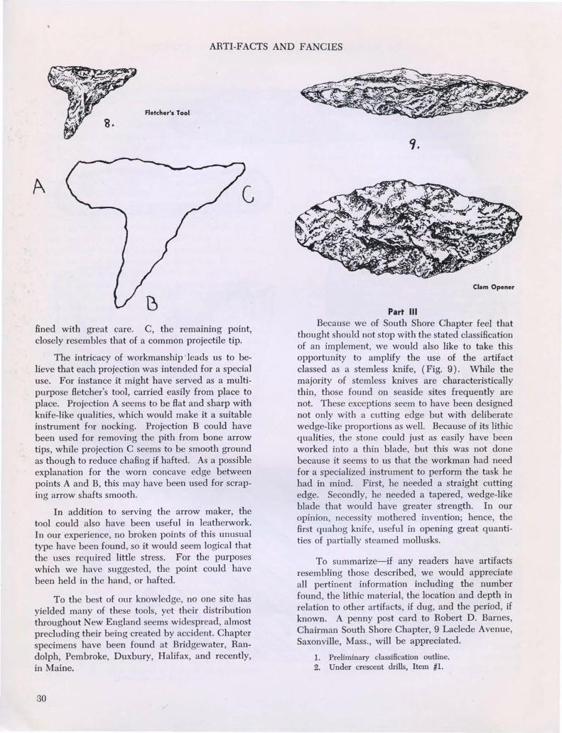
easily classifiable or as a recurring problematical,may, upon painstaking examination have importantsignificance in the overall study of archaeology.Hidden in various classifications is an artifact considered at times as a small triangularl , and at othertimes as a drill or perforator2. We consider itworthy of a sharp re-evaluation.
While the triangular projectile point is symmetrical, close examination will reveal that theexample in our illustration is not. Many of thesehave the same deviations from a symmetrical pattern. In our example (Fig. 8) projection A isbroader, shorter and Hatter than on an ordinaryprojectile point. Nevertheless it is finely workedand bears no appearance of having been broken.B, the most elongated projection, is extremelypointed, of delicate structure, and worked and re-

THE MASSACHUSETTS ARCHAEOLOGICAL SOCIETY
l.
3.
No.4 is '12 size, rest natural
29
ARTI-FACTS AND FANCIES
Fletcher's Tool
fined with great care. C, the remammg point,closely resembles that of a common projectile tip.
The intricacy of workmanship 'leads us to believe that each projection was intended for a specialuse. For instance it might have served as a multipurpose fletcher's tool, carried easily from place toplace. Projection A seems to be flat and sharp withknife-like qualities, which would make it a suitableinstrument fnr nocking. Projection B could havebeen used for removing the pith from bone arrowtips, while projection C seems to be smooth groundas though to reduce chafing if hafted. As a possibleexplanation for the worn concave edge betweenpoints A and B, this may have been used for scraping arrow shafts smooth.
In addition to serving the arrOw maker, thetool could also have been useful in leatherwork.In our experience, no broken points of this unusualtype have been found, so it would seem logical thatthe uses required little stress. For the purposeswhich we have suggested, the point could havebeen held in the hand, or hafted.
To the best of our knowledge, no one site hasyielded many of these tools, yet their distributionthroughout New England seems widespread, almostprecluding their being created by accident. Chapterspecimens have been found at Bridgewater, Randolph, Pembroke, Duxbury, Halifax, and recently,in Maine.
30
Clam Opener
Part IIIBecause we of South Shore Chapter feel that
thought should not stop with the stated classificationof an implement, we would also like to take thisopportunity to amplify the use of the artifactclassed as a stemless knife, (Fig. 9). While themajority of stemless knives are characteristicallythin, those found on seaside sites frequently arenot. These exceptions seem to have been designednot only with a cutting edge but with deliberatewedge-like proportions as well. Because of its lithicqualities, the stone could just as easily have beenworked into a thin blade, but this was not donebecause it seems to us that the workman had needfor a specialized instrument to perform the task hehad in mind. First, he needed a straight cuttingedge. Secondly, he needed a tapered, wedge-likeblade that would have greater strength. In ouropinion, necessity mothered invention; hence, thefirst quahog knife, useful in opening great quantities of partially steamed mollusks.
To summarize-if any readers have artifactsresembling those described, we would appreciateall pertinent information including the numberfound, the lithic material, the location and depth inrelation to other artifacts, if dug, and the period, ifknown. A penny post card to Robert D. Barnes,Chairman South Shore Chapter, 9 Laclede Avenue,Saxonville, Mass., will be appreciated.
1. Preliminary classification outline.2. Under crescent drills, Item #1.

THE MASSACHUSETTS ARCHAEOLOGICAL SOCIETY
THE MOORING HOLE PROBLEM .IN LONG ISLAND SOUNDby
BERNARD W. POWELL
Introduction
THE PURPORTED NORSE VOYAGES TOVINLAND in the eleventh century A.D. have received much attention in the popular literature inrecent years. When such articles are sifted of misleading statements-and the outright "hoax potential" of finds like the Beardsmore find in Ontariothere yet remains a residue to attract the impartialstudent of archaeology. At present, "authorities" onboth sides of the question as to whether LeifEricson did or did not land on the North Americanshore, hold diametrically opposed views. Suchextreme positions grade down to a "wait-and-see"middle ground held by many investigators who believe the problem cannot be settled definitely oneway or another at this time-perhaps ever.
While a great deal of literary source materialexists to the effect that one Leif-the-Lucky sailedwestward from the Greenland settlements to landon an unknown shore in the summer of 1003 A.D.no concrete artifact has ever been found in NorthAmerica that either 1) has been accepted as genuinely Norse and from the period in question by allauthorities concerned, or 2) has been found orrecorded in a manner that placed its validity abovequestion-not to mention the motives of thosefinding it. Many "finds" that have been put forth asevidences of Norse visitation in North Americahave been "discoveries" of untutored persons,curiosity seekers, or well-meaning but untrainedenthusiasts. We who are archeologically-oriented,find in this state of affairs a challenging prospect.If only a trained archeologist could come upon asite that gave evidence of occupancy by Europeansduring the time in question! This would be agreat step forward in an admittedly highly restrictedphase of North American prehistory.
Followers of archeology, however, need not bereminded of the difficulties in locating and recovering material from aboriginal sites-and the Indiansand paleo-Indians have lived in the Northeast inrelatively substantial numbers for several thousandyears. Yet all too frequently, the diligent and scientific search for their habitation sites results in absolutely nothing. Erosion, cultivation, and excavationby non-observant persons, and the slow decay and
oxidation of materials through the centuries, resultsin scattering of artifacts, obliteration of surface features, and the return of organic ~aterials to thedust whence they came. And when one recalls theexceedingly limited number of Norsemen who mayhave come out to Vinland over a decade or so( probably never in excess of 300 persons at anyonetime), and the correspondingly fewer evidences oftheir presence that must have been left behindthe magnitude of the archeological problem is seenanew. The straight odds against locating the limitednumber of campsites for these eleventh century seafarers somewhere along the North American coastare distressingly "astronomic."
This rather negative forward secures (I hope)an impartial position from which to introduce themain thesis of this article. If I seem unduly pessimistic about the presence of Norsemen along ourNew England shores a thousand years ago, it isonly because I have been so often dismayed withthe bland assumptions that the Norse did in factmake their landfall here. This is the very thing yetin the balance-to be scientifically proved-anduncritical acceptance is not to be tolerated.
Part IOne of the most promising sites for Leif's
"booths" or shelters, built as the sagas relate, forprotection during the stay in Vinland, seems to beCape Cod. A great many early theorists consideredthe latitude of the Cape as favorable for manythings observed in Vinland, i.e. altitude of the sunat midday meals, temper of the winter, botanicalphenomena and so forth. Recent work by ourfellow member, Frederick J. Pohl, goes even furtherand attempts to designate the exact .spot wherethe Norse first landed: Follins Pond on the BassRiver.
Shortly after surveying the shores of FollinsPond in 1951, I met Mr. Pohl for the first time anddiscussed with him many intriguing aspects of theentire problem. One that he mentioned at thattime-and which I have subsesquently followed upin rather more detail-concerns the possible occurrence of "mooring holes" along both shores of LongIsland Sound. That is the real substance of thispaper, and my reason for bringing it to the attention
31
This journal and its contents may be used for research, teaching and private study purposes. Any substantial or systematic reproduction, re-distribution, re-selling,loan or sub-licensing, systematic supply or distribution in any form to anyone is expressly forbidden. ©2010 Massachusetts Archaeological Society.

THE MOORI G HOLE PROBLEM IN LONG ISLAND SOUND
ies of water-or in rocks on shore and in ledges immediately offshore, if harbors or coves were toowide to permit running a line clear across them. Somoored, the vessels rode securely up and down asthe tides rose and fell: the method was a satisfactory, indigenous solution to a "problem of the environment", as I suppose cultural anthropologistsmight say. Such a method of mooring was the modusoperandi of the Vikings, and we assume that this"proper" way to moor must have been used by theirlater descendants in the Greenland colonies andthose ultimate voyagers to the shores of New Eng-
.. ' .
DRILLED HOLE
t •
o ~ ••.... :\'..
-" .., .... .. '.. .. .... " .......
,_... _: ... - -- ".
ROCK
BLASTING
CHISELED HOLE
,." .' .
~., .. ..
If) ,I , .~
,.- . ,
\".',, • '". " I, -, ... .., ....
, ," . ~ , . .. .... , -!) , -- - .., - ..' , .. .'.'. d: , A ~. - .
~ .. -... . ..' .. ,,t; . t
':, .
, .. '"---_....... ,
."0:"- ::. \," ... , . '.... -..... .' .. \..., , . . - .".... .." .....
primarily of you members of the MassachusettsArcheological Soicety is that many of you may besuited to do some field checking for us on thisproblem. I will explain what I have in mind alittle later.
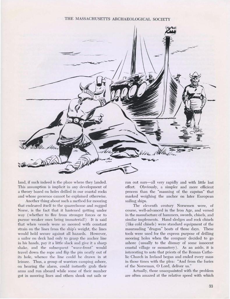
First, what exactly do we mean by a "mooringhole"? Along the shores of the fjiords in Norwayand in other waters of Scandinavia-are numerouslarge boulders and exposed rock ledges. In manyof these are holes drilled to varying diameters anddepths, and known to date from Viking times. Theywere made by Norse sailors for mooring their vessels. In use, boat lines were made fast to wroughtiron pins with eyed-ends which were inserted inthese holes.
Several things are noteworthy about theseNorse mooring holes. One is the fact that theyalmost invariably are drilled at a slight angle pastthe vertical to slope away from the direction inwhich the rope (and hence the strain) would havecome. They vary in depth-but as little as sixinches was more than adequate in many cases.Diameters may be from one inch to one and onehalf inches; a marine engineer1 has calculatedthat a wrought iron pin one inch in diameter hasan ultimate sheer value of 31,406 pounds. A vikingship sixty-five feet in length moored broadside to asixty-mile-an-hour wind would have caused a strainon each mooring line of from 1,950 to 7,500 poundswhich would have varied with the angle betweenthe hawsers (if more than one), and the directionof the wind. The same ship held bow to the windwould have presented less resisting surface orwindage, and would have created a strain of only1,080 pounds.
Another interesting aspect of the mooring holescomplex is the fact that the holes were apparentlyoften used in pairs for lines run out both fore andaft from the vessel. Many of the Norwegian fjiordsare narrow, and in those latitudes, tidal currents areswift and the daily tidal variation quite marked.Consequently, wooden vessels moored in suchpotentially dangerous waters, run considerable riskof damage. Formerly, vessels rarely, if ever, swungto a single anchor after the continental Europeanmethod. Made fast in such a manner, Norse boatswould have gyrated violently about their anchorlines and would have been swept either into oneanother or onto the numerous rocks and skerries.Therefore, they were moored both bow and stern toiron pins inserted in the drilled holes. These holesmight be in rocks on opposite shores of narrow bod-
32
THE MASSACHUSETTS ARCHAEOLOGICAL SOCIETY
-----:::-- -
_-:'~- ----~---
land, if such indeed is the place where they landed.This assumption is implicit in any development ofa theory based on holes drilled in our coastal rocksand whose presence cannot be explained otherwise.
Another thing about such a method for mooringthat endeared itself to the quarrelsome and ruggedNorse, is the fact that it hastened getting underway (whether to flee from stronger forces or topursue weaker ones being immaterial!) It is saidthat when vessels were so moored with constantstrain on the lines from the ship's weight, the lineswould hold secure against all hazards. However,a sailor on deck had only to grasp the anchor linein his hands, pay it a little slack and give it a sharpshake, and the subsequent "wave-front" wouldtravel down the rope and flip the pin neatly out ofits hole, whence the line could be drawn in atleisure. Thus, a group of warriors camping ashore,on hearing the alarm, could instantly grab theirarms and run aboard while some of their numbergot in mooring lines and others shook out sails or
..:::------
-
ran out oars-all very rapidly and with little losteffort. Obviously, a simpler and more efficientprocess than the "manning of the capstan" thatmarked weighing the anchor on later Europeansailing ships.
The eleventh century Norsemen were, ofcourse, well-advanced in the Iron Age, and versedin the manufacture of hammers, swords, chisels, andsimilar implements. Hand sledges and rock chisels(like cold chisels) were standard equipment of themaurauding "dragon" boats of those days. Thesetools were used for the express purpose of drillingmooring holes when the company decided to goashore (usually to the dismay of some innocentcoastal village or monastery). As an aside, it isinteresting to note that priests of the Roman Catholic Church in Ireland began and ended every massin those times with the plea: "And from the furiesof the Norseman, 0 Lord, deliver us."
Actually, those unacquainted with the problemare often amazed at the relative speed with which
33

THE MOORING HOLE PROBLEM IN LONG ISLAND SOUND
one can sink a hole into rock with an iron chisel.This is not a tedious operation at all. Supposedly,a good man can drill a satisfactory hole in less thanfifteen minutes, no time at all for a group preparingto moor somewhere for the night. Mr. Pohl hadsome limited experience with such hole drilling; Iquote directly from his book2: "He and his son andI, taking turns, leisurely cut a hole l)~ inches deep infive minutes. We found we could not make around hole with a straight-edge chisel. All ourattempts resulted in triangular holes with thecorners rounded." This is characteristic of suchchisel-drilled holes: they invariably present (inhorizontal cross-section) the shape of a sphericaltriangle with "bulged" sides. The holes tend totaper somewhat towards the bottom (in verticalcross-section) and this and the "bulging" is a consequence of the fact that the person drilling thehole must periodically shift the position of hischisel to maintain maximum cutting. (See illustration. )
Not every hole occurring in rocks along ourshores, however, is potentially suspect-in fact, inall probability, very few are. Of course everyoneis familiar with modern blasting practices and thedrilling of holes in rock for insertion of sticks ofdynamite. Such holes are drilled by "star-drills" orspecial rock drills which are metal cylinders thatcut away with abrasive grains (sometimes diamond) around their perimeters and thus remove asolid "slug" or core of rock. Recently-drilled holesfor blasting purposes are perfectly circular in horizontal cross-section, and when machine-drilled, maybe from one and one-half to two and one-halfinches or more in diameter. Such holes are invariably drilled in rows for the purpose of breakingTack along a definite line, and are not ordinarilyconfused with mooring holes at all. The presenceof several holes in a line removes any of themfrom consideration as a Norse mooring hole. Alongthe shores there is always the chance of findingholes left by U.S. Coast and Geodetic Surveyparties in the furtherance of their operations. Theseholes are usually adjuncts of some kind to benchmarkers or triangulation stations. A check on thispossibility may be had by comparing the locationof suspected holes with lists of triangulation stations for the area. Such lists can be obtained freeof charge from the U.S. Coast and Geodetic Survey.Anyone seriously interested in helping us is urgedto check against these lists when finding suspectedl-,nles. Usually U.S.C.&G.S. holes have either lead
34
plugs or bronze seals in them, but on occasion thesecould be missing.
A common practice of early survey crews wasto leave drill holes with "sunbursts" or outwardradiating chiseled lines surrounding them. Suchholes are automatically eliminated as Norse mooring holes. Mariners, fishermen, and others havefrom time to time erected markers along our shores,and such markers may now be long vanished. Ifthey were guyed or stayed against the wind (notunreasonable along the coast), holes might verywell have been drilled for bracing pins or legs. Inmy opinion, numerous holes around a central spotargue against a mooring hole origin. One authority3states that colonial fishermen made many holes inour coastal rocks. Isolated holes showing weathering, and at angles and in locales likely to have beenutilized by ancient mariners for mooring theirships, are the most likely candidates for true mooring hole status. It should be remembered that manyof the "mooring holes" found on the Cape are noweroded and in some places broken clean through(presumably with time and thermal shock) and arethus assumed to be quite old. Certainly weathering of the stone is important, but this is often asubjective judgment, and an aspect of the problemthat cries for more research in its own right. Remember too, that prevailing winds enter into thepicture in the Sound; in summer they are southwestand vessels would be moored out of such windsaccordingly.
And there are other agents responsible forholes in rocks along our shores. Again I quotefrom Mr. Pohl4: "Some holes have been made bygrinding or pounding that wore away the rock byuse, and these are generally large in diameter andwere made by Indians. Other holes have beenmade by rotating drills, consisting of reeds orcylinders of wood, the cutting being done by wetsand. This method has been used for thousands ofyears by jade cutters. Where these perfectly roundholes are very small, ~ inch or less in diameter,they were probably made by primitive men forreligious or other reasons unknown or unguessed atby us. Some of these small drilled holes are deep;others are shallow depressions."
As I have mentioned previously5, certainmarine gastropods ("snails", etc.) are equipped witha hard, horny, chewing apparatus technically calleda radula, and with this they can actually chew holesinto rock. Ordinarily, the radula is most developed

THE MASSACHUSETTS ARCHAEOLOGICAL SOCIETY
in predatory forms that chew through the shells ofother mollusks, but along exposed shores, thesemarine animals can chew holes right down into therock, and do so usually to secure a burrow in whichto live and not be washed away by the waves.These holes are sometimes symmetrical and whenold enough and weathered, might conceivably giverise to some speculation. Generally, however, theymay be noted as having rather widened, taperingvertical cross-sections, and colonies of such marineanimals will, over a period of years, likely chewmore than one isolated hole in the rocks of thewaters where they abound. These then, are onlypartial explanations for the occurrence of manyholes in rocks along our shores; further study willno doubt clarify this picture and perhaps add tothe list of possible causes for such holes. But anyhole that is 1) isolated in a large rock or ledge, 2) isobviously not "fresh" i.e. shows some degree ofweathering, 3) has characteristically "bulged" sidesand rounded corners, 4) agrees generally withdimensions and angles for mooring holes as mentioned previously, and 5) is logically located withregard to suitable anchorages for vessels, is at leastsuspect and we would like to know where anysuch occur in the circum-Sound region, on thesouth shore of Long Island, and in the vicinity ofLower New York Bay and Staten Island.
Part IIThat such mooring holes might be expected in
this region is a consequence of the so-called "Thorvald Small-Boat Theory." This concerns the exploration of waters somewhere west of Vinland byone Thorvald Ericson, brother to Leif-the-Lucky.Thorvald came out to Vinland with a picked crewin Leif's boat which he had borrowed for theoccasion. The year was 1005 A.D., and the sagas(Flateyfarbok version) relate that the followingspring Thorvald directed a portion of his followersto take the ship's longboat (small boat carriedaboard the larger ocean-going vessel) and explorethe region west of Vinland. This a group of menis supposed to have done, staying out the wholesummer in the process and returning to the Vinlandbase in the fall. In respect to this incident, I quoteFohl at length6 : "'In the spring Thorvald ordereda few men to take the afterboat and explore alongthe coast to the west during the summer. Thesemen found it a pleasing, well-wooded country,with the woods near the white sands. There weremany islands and shoals. They found no dwellingsof men or lairs of beasts, but in one of the islands to
the west they found a corncrib of wood. They returned to Leif's Shelters at harvest-time.'
Since Thorvald's afterboat party spent theentire summer exploring to the west from theVinland camp site and did not return for the ship,we may safely deduce that they found a boat assmall as the afterboat (about the size of a whaleboat) entirely adequate, and therefore that it wasnot open ocean which lay to the west of them, butextensive inland waters. These inland waters musthave been Nantucket Sound, Vineyard Sound, Buzzards Bay, Narragansett Bay and the inlets of LongIsland Sound. A party of only a few men, observingnatural caution against the possibility of attack byunfriendly natives, must have fastened their boatmany a night to mooring holes in rocks off thewooded shores, since one man could have chiseledan adequate mooring hole in about fifteen minutes.The islets off the shore line of these inland watersmight well be searched for such mooring holes."
In the fall of 1954, I discovered the beginningsof a chisel-drilled hole in a shoreline boulder of asmall island. This island is located in a cove onthe Connecticut shore in the western end of theSound. The hole could be such a mooring hole, ormore properly, the beginnings of a mooring hole,for it is only an inch or so deep and was apparentlynever finished. Diligent search of the rest of theisland failed to disclose any other holes or significant features, save other than a tiny, worn, pit-likedepression on top of a massive glacial erratic atthe southern end of the island. This find bears norelationship to the suspected hole.
Further survey revealed another likely hole onan island at the entrance to a harbor a mile or twowest of the first site. This second hole was foundin the summer of 1955. It too, was isolated, andwas quite a bit deeper (deep enough to have beenfunctional) and was situated in a manner convenient for mooring a vessel in the prescribed manner and out of the roll of a Southwesterly sea. Thefinding of these two holes was reported by severallocal newspapers, which, unfortunately, statedrather flatly that the holes had been "made byNorsemen." This is, perhaps, the unavoidable can.sequence of stories in the popular press, but theauthor wishes to state here that the holes are, ofcourse, only tendered as tentative mooring holefinds predicated on the basis of the "ThorvaldSmall-Boat-Theory." One swallow does not makea summer, and two holes don't clinch the hypothetical wanderings of theoretical Vikings!
35

THE MOORING HOLE PROBLEM IN LONG ISLAND SOUND
That one hole is not finished is not against itshaving been at least the start of a mooring hole.Perhaps a group intended to camp on or near thefirst island one night but later reconsidered. Theymight have very well started a hole, then movedon-perhaps to the next island. Such theorizing isadmittedly far-fetched, but if there is anything atall to the entire notion, we must try to examineevery possibility and follow up every lead so thatwe can ultimately find for or against the postulation.
It is, therefore, the author's hope that interestedamateur archeologists such as yourselves, could bedrawn to this phase of the overall problem andcooperate by informing me of any likely holes youmight locate along the shores of Long Island Soundor its headlands, or in its coves, bays, harbors andriver tributaries. Spread the word in your ownarea and personally evaluate such finds yourselves.If they seem worthy of further consideration, writeand let me know. Give their exact locations (nameof harbor, point, etc.) and where located i.e. eastside, west side, etc. Also send data on how farthey are from present mean tide levels, and anyother pertinent information about them, such asweathering, presence of "bulged" sides, whetheryou have checked them against Coast and GeodeticSurvey lists, and so forth. Photographs would bevery desirable and could include a general viewof the rock or ledge, and perhaps a close-up of thehole with a scale indicator in the picture. I don'tknow just what we can expect to develop from allthis. Perhaps we will bring to light so many drilledholes in our shoreline rocks that it would havetaken a veritable armada of Vikings drilling dayand night to explain all of them! Again, we mayget some meaningful pattern when plotting finds ona map of the region . .. Without the effort it isimpossible to say. At all events, an open invitationis extended to those who would like to assist in"Project Thorvald": an attempt to test a theorystemming from assumed presence of Norsemen ineleventh century North America.
Author's Note:
The subject of this paper was presented beforethe Massachusetts Archeological Society at theannual Fall meeting in October, 1957. Variousmembers at that time raised questions relative tooriginal studies of mooring holes in Scandinavia(presumably by Danish or Norwegian archeologists). The author has no first hand knowledge ofsuch studies, but presumes them to have been
36
undertaken. Likewise, questions bordering therealm of geology were advanced relative to rockweathering, shoreline emergence/submergence, etal. The author doubts seriously that reliable datafor the time span we are treating are available onsuch things-particularly as to the weathering ofcoastal rock. I know of no study on just this subject, and previous research along similar lines (seeproblem on decay and fossilization rates of organicmaterial in Cape Cod soils, in author's "An OsseusFind At Follins Pond", Massachusetts Archeological Society Bulletin, Vol. XVIII, No.2, January1957. ), did not yield worthwhile geological information.
However, the author wishes to draw attentionto the fact that this paper is not an attempt to bedefinitive on the subject, but merely introductoryto some limited investigations. For such an approach, a delving into Scandinavian sources (possibly not translated into English?) or attempts todefine chemical and physical alterations in coastalrocks in the past 1000 years, does not seem to benecessary. B.W.P.
Footnotes
1. POHL, p. 86.
2. POHL, p. 86.
3. BHONDSTED, p. 399.
4. POHL, p. 85.
5. Stamford Advocate, Sept. 29, 1955, The Village Gazette,
Sept. 9, 1955 and Greenwich Time, Sept. 19, 1955.
6. POHL, p. 124-25.
References
BnONDsTED, JOHANNES
1954. Norsemen in North America Before Columbus.
A previously published article appearing in the
Annual Report of the Smithsonian Institution for
1953, pp. 367-405, United States Government
Printing Office, Washington, D. C.
POHL, FREDEHICK J.
1952. The Lost Discovery. W. W. Norton & Co., Inc.,
New York.
Newspapers: Stamford Advocate, Stamford, Conn.; The
Village Gazette, Old Greenwich, Conn.; and
Greenwich Time, Greenwich, Conn.
EDITORIAL COMMENT .....
Several recently submitted papers have varied in typing and spacing, makingit necessary to go through a tedious re-typing process prior to printing. Manuscripts should be typed full page on standard 8~xll inch paper, double spaced,and on one side of the page only. Any footnotes should be held to a minimum, andtyped at the end of the article. Bibliographies should take this form-
Fuller, Harry1954. "Culture Traits of the Micmac Tribe."
Mass. Arch. Soc. Bulletin, Vol. 10, No.3, pp. 46-52.
This standard procedure will aid greatly in estimating Bulletin spacing for16, 20 or 24 page issues.
ONE VIEWPOINT
Once again we hear a classic and time worn objection to archaeologicalresearch. An Associated Press dispatch from Peterborough, Ontario, quotesIndian guide Dan Musgrove, aged 71, as saying: "They took away all our lands.Now they're digging up our ancestors to see whether they took anything withthem." This in reference to the excavation of a burial mound near Rice Lake.
BLUEPRINT DANGER
A word of caution may be in order regarding too stereotyped a classificationof any ancient culture level. Weapons and tools show the cumulative result ofhereditary skill practiced over a long period from a common aboriginal root.
In England the flint chipping technique of the Stone Age did not reach itsculmination until the earlier stages of the Bronze Age, when metal was still toorare to satisfy the demand for more advanced forms, and persisted even whennew materials had become more generally available. In lowland Britain a distinct flint industry has been recognized for the Late Bronze Age; and, on areduced basis, during the Early Iron Age.
Is the remaining recoverable evidence from the ground conclusively synonomous with the tribal culture of an area at a given period? Are we giving dueimportance to a constant infiltration of ideas and methods from without whichdilute and modify tribal characteristics? Is classification tending toward a closedsystem of cultural stages laborously worked out to scale, or is it more correctlya flowing and constantly changing medium which cannot properly be pinpointed to any static period?
This journal and its contents may be used for research, teaching and private study purposes. Any substantial or systematic reproduction, re-distribution, re-selling,loan or sub-licensing, systematic supply or distribution in any form to anyone is expressly forbidden. ©2010 Massachusetts Archaeological Society.