matti€kummu.€2009.€water€management€in€angkor...
TRANSCRIPT

Matti Kummu. 2009. Water management in Angkor: Human impacts on hydrology andsediment transportation. Journal of Environmental Management, volume 90, number 3,pages 14131421.
© 2008 Elsevier Science
Reprinted with permission from Elsevier.
lable at ScienceDirect
Journal of Environmental Management 90 (2009) 1413–1421
Contents lists avai
Journal of Environmental Management
journal homepage: www.elsevier .com/locate/ jenvman
Water management in Angkor: Human impacts on hydrology andsediment transportation
Matti Kummu*
Helsinki University of Technology, Water resources laboratory, Tietotie 1E, 02150 ESPOO, Finland
a r t i c l e i n f o
Article history:Received 7 November 2007Received in revised form 3 August 2008Accepted 25 August 2008Available online 15 October 2008
Keywords:Human impact on hydrologyWater managementSpatial analysisAngkorCambodia
* Corresponding author. Tel.: þ358 9 451 3833; faxE-mail address: [email protected]
0301-4797/$ – see front matter � 2008 Elsevier Ltd.doi:10.1016/j.jenvman.2008.08.007
a b s t r a c t
The city of Angkor, capital of the Khmer empire from the 9th to 15th century CE, is well known for itsimpressive temples, but recent research has uncovered an extensive channel network stretching acrossover 1000 km2. The channel network with large reservoirs (termed baray) formed the structure of thecity and was the basis for its water management. The annual long dry season associated with themonsoon climate has challenged water management for centuries, and the extensive water managementsystem must have played an important role in the mitigation of such marked seasonality. However, bychanging the natural water courses with off-take channels the original catchments were also reshaped.Moreover, severe problems of erosion and sedimentation in human built channels evolved and impactedon the whole water management system. This paper describes the present hydrology of the area anddiscusses the impacts of water management on hydrology during the Angkor era. The paper, moreover,attempts to summarise lessons that could be learnt from Angkorian water management that might applyto present challenges within the field.
� 2008 Elsevier Ltd. All rights reserved.
1. Introduction
Water is crucial for every civilisation and human settlement.Safe and reliable access to clean water throughout the year isfundamental for sustainable population growth and development.The monsoon climate has for a long time challenged human kind tostore water for the dry season (e.g. Barker and Molle, 2004) and/orto find reliable sources of water that are available year-round, suchas easily accessible groundwater. The city of Angkor, the capital ofthe Khmer empire from the 9th to 15th century CE, developed anextensive water management system over hundreds of years inorder to meet these challenges.
Angkor was, at its peak, the most extensive pre-industrial low-density urban complex in the world (Fletcher, 2001; Evans et al.,2007). It is located in the vicinity of Tonle Sap Lake in present-dayCambodia (Fig. 1) and by the 12th century, the Khmer empire ruledmost of the mainland of Southeast Asia. Angkor is famous for itsmonumental religious constructions, such as Angkor Wat andBayon. The temples are, however, just a part of the whole citystructure. The French archaeologist Bernard-Philippe Groslier(1967, 1974, 1979) was among the first to recognise that Angkor hadan extensive hydraulic system based on channels and reservoirs. He
: þ358 9 451 3856.
All rights reserved.
proposed an integrated programme of archaeological research thattook into account both the ‘vertical’ dimension (e.g. traditionalexcavation techniques) and the ‘horizontal’ dimension, exemplifiedby his (1979) time-sequence series of maps derived from aerialsurvey. He was, however, unable to complete the programme dueto unstable conditions in Cambodia from the early 1970s to thebeginning of 1990s.
Recent research has uncovered an even more extensivehydraulic network stretching across 1000 km2 (Pottier, 1999;Fletcher, 2001; Evans, 2002; Evans et al., 2007) by using moresophisticated remote sensing techniques than those available toGroslier. Although Angkor’s hydrology and hydraulic system areprobably not as well understood as its religious architecture, it hasbeen argued already by Groslier (1974), and again with furtherevidence by Evans et al. (2007), that they may have played animportant role in the operation of the city. The large watermanagement features, such as channels and baray (large waterreservoirs), seem to represent the boundary of the city during theAngkor era. Groslier’s hydraulic thesis, however, has attractedcriticism and contradictory theories have been proposed (e.g. vanLiere, 1980, 1982; Acker, 1998).
This article aims first to present the key characteristics of thepresent hydrology of the Angkor area to form a basis for under-standing the water management opportunities and challengesduring the Angkor era. Water management in Angkor was basedmainly on four sources of water: (1) natural rivers, (2) groundwater,
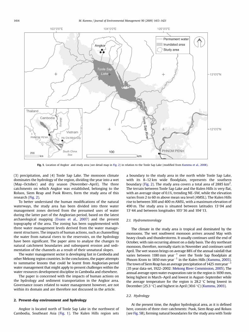
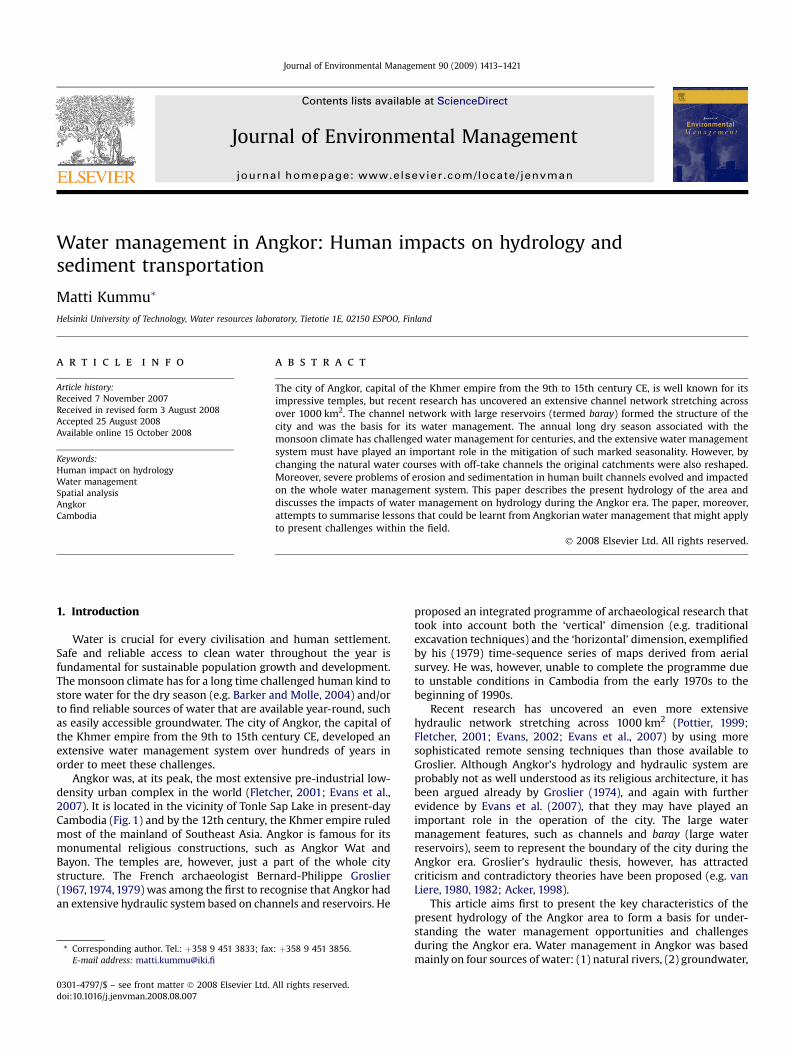
Fig. 1. Location of Angkor and study area (see detail map in Fig. 2) in relation to the Tonle Sap Lake (modified from Kummu et al., 2008).
M. Kummu / Journal of Environmental Management 90 (2009) 1413–14211414
(3) precipitation, and (4) Tonle Sap Lake. The monsoon climatedominates the hydrology of the region, dividing the year into a wet(May–October) and dry season (November–April). The threecatchments on which Angkor was established, belonging to theRoluos, Siem Reap and Puok Rivers, form the study area of thisresearch (Fig. 2).
To better understand the human modifications of the naturalwaterways, the study area has been divided into three watermanagement zones derived from the presumed uses of waterduring the latter part of the Angkorian period, based on the latestarchaeological mapping (Evans et al., 2007) and the presenttopography of the area. The zoning has been supplemented withthree water management levels derived from the water manage-ment structures. The impacts of human actions, such as channellingthe water from natural rivers to the reservoirs, on the hydrologyhave been significant. The paper aims to analyse the changes tonatural catchment boundaries and subsequent erosion and sedi-mentation of the channels as a result of their unnatural slopes.
The water management sector is developing fast in Cambodia andother Mekong region countries. In the conclusions, the paper attemptsto summarise lessons that could be learnt from Angkorian-periodwater management that might apply to present challenges within thewater resources development discipline in Cambodia and elsewhere.
The paper is concerned with the impacts of human actions onthe hydrology and sediment transportation in the Angkor area.Governance issues related to water management however, are notwithin its domain and are therefore not discussed in the article.
2. Present-day environment and hydrology
Angkor is located north of Tonle Sap Lake in the northwest ofCambodia, Southeast Asia (Fig. 1). The Kulen Hills region sets
a boundary to the study area in the north while Tonle Sap Lake,with its 8–12 km wide floodplain, represents the southernboundary (Fig. 2). The study area covers a total area of 2885 km2.The terrain between Tonle Sap Lake and the Kulen Hills is very flat,with an average slope of 0.1%, trending NE–SW, while the elevationvaries from 2 to 60 m above mean sea level (AMSL). The Kulen Hillsrise to between 300 and 400 m AMSL, with a maximum elevation of490 m. The study area is situated between latitudes 13�04 and13�44 and between longitudes 103�36 and 104�13.
2.1. Hydrometeorology
The climate in the study area is tropical and dominated by themonsoons. The wet southwest monsoon arrives around May withheavy clouds and thunderstorms. It usually continues until the end ofOctober, with rain occurring almost on a daily basis. The dry northeastmonsoon, therefore, normally starts in November and continues untilApril. The wet season brings on average 88% of the annual rainfall thatvaries between 1180 mm year�1 over the Tonle Sap floodplain atPhnom Krom to 1850 mm year�1 in the Kulen Hills (Kummu, 2003).The town of Siem Reap has an average precipitation of 1425 mmyear�1
(35 year data-set, 1922–2002: Mekong River Commission, 2005). Theannual average open water evaporation rate in the region is 1690 mm,being highest in March–April and lowest in August–September whilethe average temperature for the region is 28.2 �C being lowest inDecember (25.3 �C) and highest in April (30.6 �C) (Kummu, 2003).
2.2. Hydrology
At the present time, the Angkor hydrological area, as it is definedhere, consists of three river catchments: Puok, Siem Reap and Roluos(see Fig. 5B), forming natural boundaries for the study area with Tonle
104°10'0"E104°0'0"E103°50'0"E103°40'0"E
13°40'0"N
13°30'0"N
13°20'0"N
Tonle Sap Lake
Kulen Hills
70 m AMSL
10km
300 m AMSL
Puok R
iver
1
6
89
2
34
5
710
11
1: Great North Canal2: Angkor Thom3: Angkor Wat4: West Baray5: East Baray6: Jayatataka (North Baray) 7: Indratataka (Baray of Loley) 8: Southeast Canal9: Southwest Canal
11: Phnom Krom
Sie
m R
eap R
iver
Rolu
os R
iver
10: Angkor Wat Canal
Constructed canalsWaterFloodplainStudy area
Rivers
Fig. 2. Map of the study area and location of the major hydraulic features and main temples. Source of the GIS data: natural rivers, lake, contours, and flood plain from the MekongRiver Commission (2005); linear and storage features from Evans et al. (2007).
M. Kummu / Journal of Environmental Management 90 (2009) 1413–1421 1415
Sap Lake (Fig. 2). The natural rivers originate in the Kulen Hills and draindown to Tonle Sap Lake. The average annual runoff for the threecatchments is around 500 mm. The characteristics of the Roluos, SiemReap and Puok Rivers are reviewed in more detail in Kummu (2003).
Groundwater is another important source of water for theAngkor region. It is easily accessible, as the water table lies betweendepths of 0 and 5 m below ground level during the wet and dryseasons, respectively (JICA, 2000; JSA, 2002). This offers relativelyeasy and reliable access to clean water during the dry season, whichis crucial for sustainable community development. Seasonal vari-ation in the groundwater level clearly follows the precipitationpattern (see Kummu, 2003). The groundwater aquifer seems to berather homogenous, i.e. having the water table close to the groundsurface, over a large part of the terrain between the Tonle Sapfloodplain and Kulen Hills (JSA, 2002; Friedli, 2003).
Although the groundwater is rather easily accessible in the Angkorarea, the depth to the groundwater table varies greatly around the TonleSap area. It depends on the depth of the bedrock and the characteristicsof the soil. In Kralanh District, west of Siem Reap, the surface of theaquifer is located at depths greater than 40 m, while in Sotr Nikum, eastof Siem Reap, the groundwater table lies between 11 and 12 m deep(Garami and Kertai, 1993). Therefore, Angkor is clearly located on aneasily accessible aquifer compared to its surrounding areas.
2.3. Tonle Sap Lake
Tonle Sap Lake is the largest permanent freshwater body inSoutheast Asia. At the present time, the area of the lake varies
between the dry and wet seasons, from an area of 2300 km2 up tobetween 10,000 km2 and 15,000 km2, while the water level of thelake increases from around 1.44 to 6.8–10.3 m AMSL in HatienDatum (Kummu et al., 2008; Kummu and Sarkkula, 2008). That is,while the water level recedes to similar levels each year, the floodpeak varies greatly (Kummu and Sarkkula, 2008). Since the bottomof the lake has an elevation of around 0.7 m AMSL, the water is veryshallow (depths of less than 1 m) at the end of the dry season.
The Tonle Sap is believed to be among the most productivefreshwater ecosystems in the world (Rainboth, 1996; Bonheur,2001). Its high productivity is driven mainly by flooding from theMekong River, which transfers primary products of terrestrialorigin into the aquatic system (Lamberts, 2001, 2006; MRCS/WUP-FIN, 2003; Sarkkula et al., 2005; Kummu et al., 2006). The flood-plain of the lake, and particularly the gallery forest and scrublandsat its margin, offers favourable conditions for breeding and growthfor migratory fish from the Mekong River (Poulsen et al., 2002).
The lake supports the majority of the present-day commercialand household fisheries of Cambodia and provides a significant partof the animal protein intake for the whole country. More than onemillion people are directly dependent on the natural resources(mainly fish þ farming) of the lake at the present time (Keskinen,2006). It is very probable that the Tonle Sap was a major andessential food supply, particularly of fish, for communities duringthe Angkor era.
Besides fish and other natural resources, the lake was also animportant part of the transportation network for Angkor. Goodsand people were easily moved between regional centres and the
M. Kummu / Journal of Environmental Management 90 (2009) 1413–14211416
capital by boats, particularly during the wet season (Hendrickson,2007, p. 259). In relation to Tonle Sap Lake, the location of Angkor isclose to ideal. It is safe from the flood but at the same time veryclose to the lake even during the dry season. The floodplain isrelatively narrow in the Angkor region (on average some 12–14 kmin width) compared to the other parts of the lake where it can befour times as large (see Fig. 1). This made Angkor relatively acces-sible by boat even during the dry season.
3. Water management: levels and zones
The water management system is discussed here from twodifferent perspectives: levels and zones. The three water manage-ment levels, listed and briefly discussed in Section 3.1, are based onthe water management structures while the zones are derived fromthe ways the water was managed through the landscape at a largerscale. The levels highlight the diversion of water management atdifferent scales, and also within each of the zones.
3.1. Water management levels
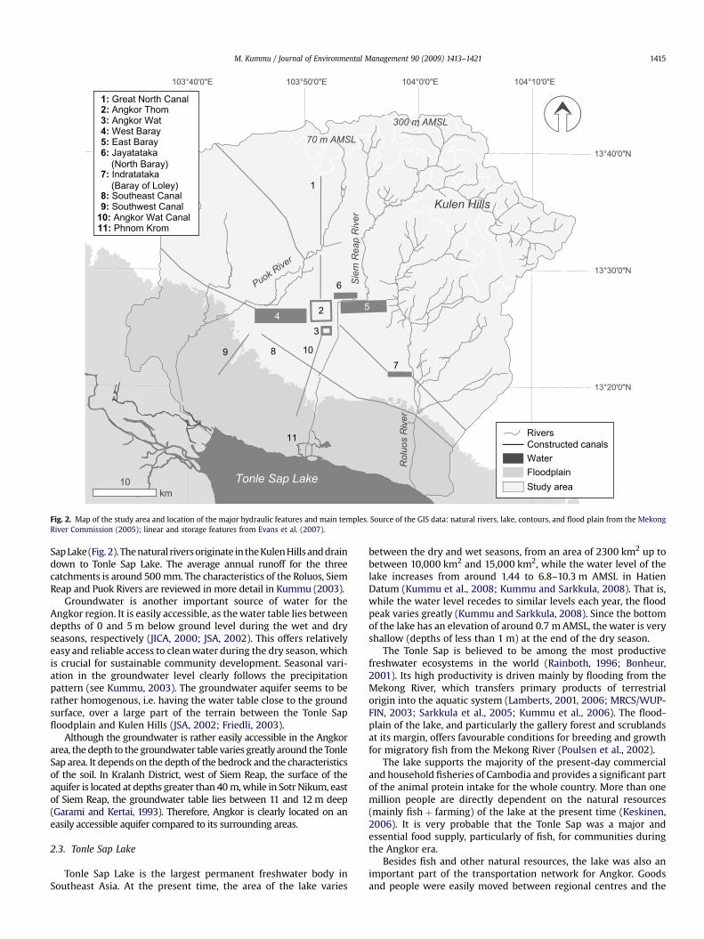
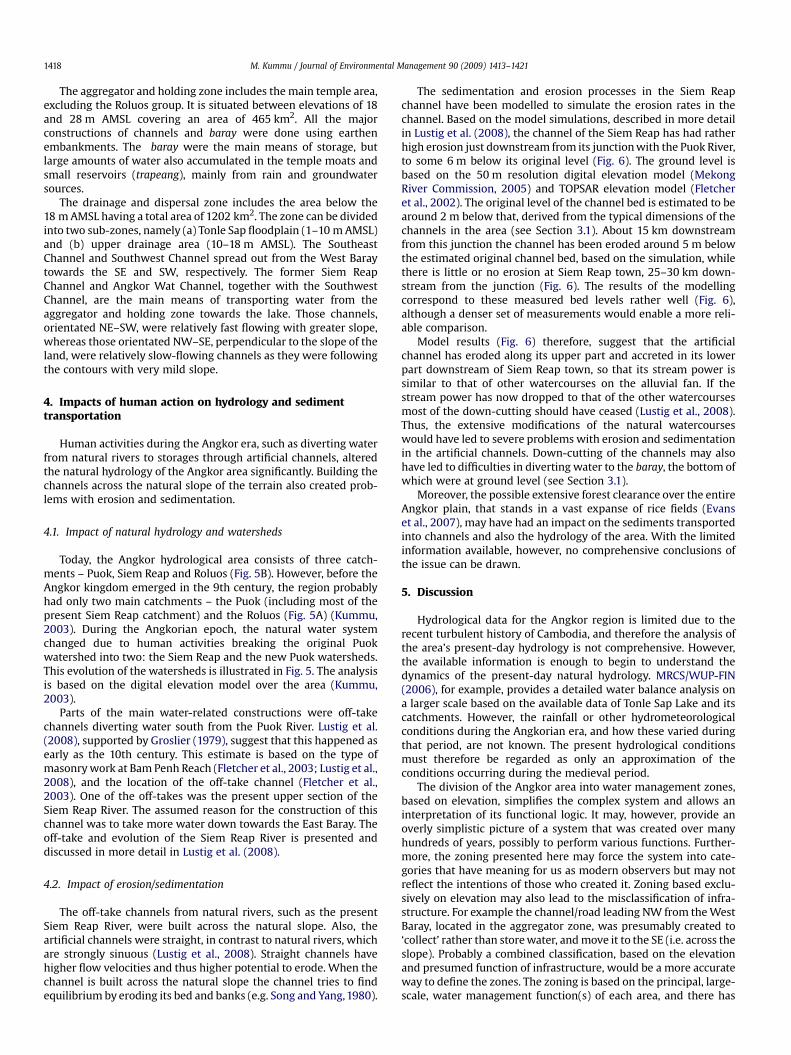
During the Angkorian era, each of the management levels hadits typical water management structures (Fig. 3). In this paper thethree principal management levels are defined as: (a) householdlevel; (b) village level; and (c) city level. This hierarchy is based onthe type and size of the structures. The possible governance issuesrelated to these structures and water management levels, however,are not within the domain of the paper.
Many of the houses were built on small mounds (Fig. 3a) thatraised the house above the flood. Due to the long dry season, thecollection and storage of water was very important. At the house-hold level, this was accomplished by building/excavating smallponds which were dug into the water table. For village use, bigger
Household level
House mound
A A
Section A-A
Trapeang/pound
Village level
B B
Section B-B
Baray
Linear feature -accross the slope
Linear feature -parallel to the slope
City level
C C
Section C-C
Slop
e Slope
Slop
e Slope
a
b
c
Fig. 3. Schematic illustration of the water management levels and typical associatedstructures. The different levels include: (a) household, (b) village, and (c) city levels(adapted from Pottier, 1999).
ponds (trapeang) were built (Fig. 3b). Typically, trapeang wereclosely connected with the temples. The vast majority of trapeanghad a length–width ratio of 2:1 and were generally aligned E–W(Pottier, 1999; Evans, 2002). Almost every temple had also its ownmoat which was also dug into the water table. The moats weresquare or rectangular and generally oriented E–W and N–S (Pottier,1999). Water was normally collected in the moats, house ponds andtrapeang from rain and groundwater sources.
At the city level, two principal water management features canbe identified: baray (large reservoirs) and linear features (channels,roads and embankments). It can be argued that these large-scalehydraulic features formed the city’s intercommunication network(Fig. 4). In the urban area (aggregator and holding zone; see Section3.2) the water was collected in baray, which were fed by channelsoriginating from the natural rivers (in the collector zone). Angkorhas four major baray: Indratataka (Baray of Lolei), Yasodharatataka(East Baray), West Baray, and Jayatataka (North Baray). Baray werefed directly by the channel network and rainfall. They were largelybuilt by creating earthen embankments around a large enclosedarea with limited excavation (Fig. 3c) (e.g. Fletcher, 2001). Channelscriss-crossed the whole landscape (see Fig. 4). They were generallyvery shallow (1–2 m below ground level) and rather wide (30–40 m). The shallow channels kept the water as high as possible inorder to supply the baray, the bottom of which were at groundlevel. Embankment(s) of the channels were approximately 1–2 mabove the natural land surface and were often used as a road at thesame time, and therefore serving multiple purposes.
3.2. Water management zones
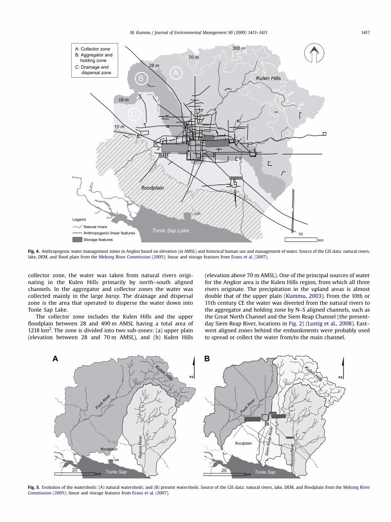
The catchments of the Tonle Sap floodplain were fundamentallyaltered during the Angkorian period by diverting the water fromnatural rivers through channels to large reservoirs, creating a newsystem for dividing the landscape according to the use and manage-ment of water (Kummu, 2003). Thus, it appears to be desirable to dividethe study area into water management zones according to elevation,spatial location of the major hydraulic features (Fig. 2), and thepresumed historical use of water during the Angkorian era, to assessthe range of causes and effects. The study area can be divided into threeprincipal zones (Fig. 4): (A) collector zone; (B) aggregator and holdingzone (temple zone); and (C) drainage and dispersal zone.
The extent of the water management system can be roughlybased on the linear water features illustrated in Fig. 4, coveringapproximately 1200 km2 of the study area (2885 km2). The zoning,however, has been done for the whole study area to include thenatural rivers and the whole floodplain in the analysis. The watersystem has been mapped for the two lower zones by Pottier (1999)using aerial photographs with extensive and systematic groundtruthing. The collector zone has been mapped using radar images(Evans, 2002) and aerial photographs using GIS (Evans et al., 2007),supported by extensive field work.
The zoning was first presented by Kummu (2003) and it iselaborated further here by using the latest archaeological mapping(Evans et al., 2007) together with the elevation of the terrain. Theborders of each zone are based here purely on elevation to keep thedefinition of the zones simple and transparent. However, one couldargue whether different hydraulic features and structures shouldbe combined with the elevation data to define the boundaries ofthe three zones and better reflect their water management func-tions. Moreover, the zoning is, at this stage, synchronic althougha diachronic description of the water management zoning would bemore valuable and reflect the development of the complex systemover several centuries more accurately. The issue is discussed inmore detail in Section 5.
Each zone has its typical water management characteristicsirrespective of the natural catchment boundaries. In the
Kulen Hills
10 m
18 m
28 m
70 m
AB
C
floodplain
Tonle Sap Lake
300 m
Legend
Natural rivers
Storage featuresAnthropogenic linear features
A: Collector zoneB: Aggregator and holding zone C: Drainage and dispersal zone
10km
Fig. 4. Anthropogenic water management zones in Angkor based on elevation (in AMSL) and historical human use and management of water. Source of the GIS data: natural rivers,lake, DEM, and flood plain from the Mekong River Commission (2005); linear and storage features from Evans et al. (2007).
M. Kummu / Journal of Environmental Management 90 (2009) 1413–1421 1417
collector zone, the water was taken from natural rivers origi-nating in the Kulen Hills primarily by north–south alignedchannels. In the aggregator and collector zones the water wascollected mainly in the large baray. The drainage and dispersalzone is the area that operated to disperse the water down intoTonle Sap Lake.
The collector zone includes the Kulen Hills and the upperfloodplain between 28 and 490 m AMSL having a total area of1218 km2. The zone is divided into two sub-zones: (a) upper plain(elevation between 28 and 70 m AMSL), and (b) Kulen Hills
A
Tonle Sap20
km
Kule
n H
ills
Puok R
iver
Rolu
os R
iver
floodplain
Fig. 5. Evolution of the watersheds: (A) natural watersheds; and (B) present watersheds. SoCommission (2005); linear and storage features from Evans et al. (2007).
(elevation above 70 m AMSL). One of the principal sources of waterfor the Angkor area is the Kulen Hills region, from which all threerivers originate. The precipitation in the upland areas is almostdouble that of the upper plain (Kummu, 2003). From the 10th or11th century CE the water was diverted from the natural rivers tothe aggregator and holding zone by N–S aligned channels, such asthe Great North Channel and the Siem Reap Channel (the present-day Siem Reap River, locations in Fig. 2) (Lustig et al., 2008). East–west aligned zones behind the embankments were probably usedto spread or collect the water from/to the main channel.
Tonle Sap20
km
B
Kule
n H
ills
Puok R
iver
Rolu
os R
iverfloodplain
Sie
m R
eap R
iver
urce of the GIS data: natural rivers, lake, DEM, and floodplain from the Mekong River
M. Kummu / Journal of Environmental Management 90 (2009) 1413–14211418
The aggregator and holding zone includes the main temple area,excluding the Roluos group. It is situated between elevations of 18and 28 m AMSL covering an area of 465 km2. All the majorconstructions of channels and baray were done using earthenembankments. The baray were the main means of storage, butlarge amounts of water also accumulated in the temple moats andsmall reservoirs (trapeang), mainly from rain and groundwatersources.
The drainage and dispersal zone includes the area below the18 m AMSL having a total area of 1202 km2. The zone can be dividedinto two sub-zones, namely (a) Tonle Sap floodplain (1–10 m AMSL)and (b) upper drainage area (10–18 m AMSL). The SoutheastChannel and Southwest Channel spread out from the West Baraytowards the SE and SW, respectively. The former Siem ReapChannel and Angkor Wat Channel, together with the SouthwestChannel, are the main means of transporting water from theaggregator and holding zone towards the lake. Those channels,orientated NE–SW, were relatively fast flowing with greater slope,whereas those orientated NW–SE, perpendicular to the slope of theland, were relatively slow-flowing channels as they were followingthe contours with very mild slope.
4. Impacts of human action on hydrology and sedimenttransportation
Human activities during the Angkor era, such as diverting waterfrom natural rivers to storages through artificial channels, alteredthe natural hydrology of the Angkor area significantly. Building thechannels across the natural slope of the terrain also created prob-lems with erosion and sedimentation.
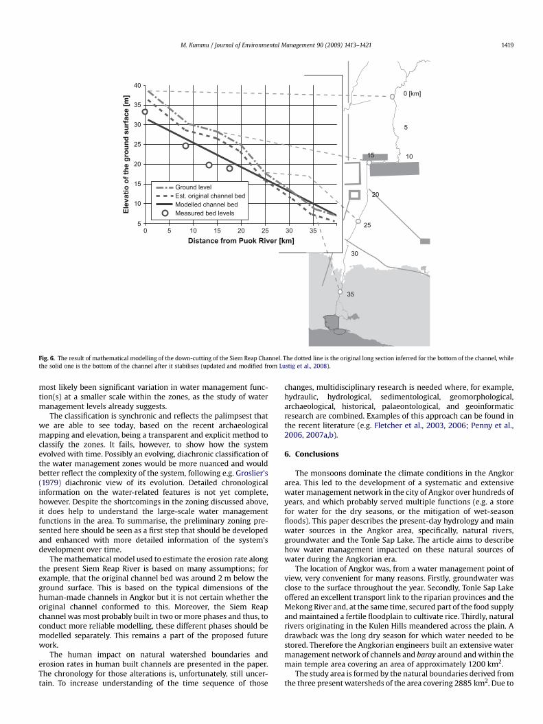
4.1. Impact of natural hydrology and watersheds
Today, the Angkor hydrological area consists of three catch-ments – Puok, Siem Reap and Roluos (Fig. 5B). However, before theAngkor kingdom emerged in the 9th century, the region probablyhad only two main catchments – the Puok (including most of thepresent Siem Reap catchment) and the Roluos (Fig. 5A) (Kummu,2003). During the Angkorian epoch, the natural water systemchanged due to human activities breaking the original Puokwatershed into two: the Siem Reap and the new Puok watersheds.This evolution of the watersheds is illustrated in Fig. 5. The analysisis based on the digital elevation model over the area (Kummu,2003).
Parts of the main water-related constructions were off-takechannels diverting water south from the Puok River. Lustig et al.(2008), supported by Groslier (1979), suggest that this happened asearly as the 10th century. This estimate is based on the type ofmasonry work at Bam Penh Reach (Fletcher et al., 2003; Lustig et al.,2008), and the location of the off-take channel (Fletcher et al.,2003). One of the off-takes was the present upper section of theSiem Reap River. The assumed reason for the construction of thischannel was to take more water down towards the East Baray. Theoff-take and evolution of the Siem Reap River is presented anddiscussed in more detail in Lustig et al. (2008).
4.2. Impact of erosion/sedimentation
The off-take channels from natural rivers, such as the presentSiem Reap River, were built across the natural slope. Also, theartificial channels were straight, in contrast to natural rivers, whichare strongly sinuous (Lustig et al., 2008). Straight channels havehigher flow velocities and thus higher potential to erode. When thechannel is built across the natural slope the channel tries to findequilibrium by eroding its bed and banks (e.g. Song and Yang, 1980).
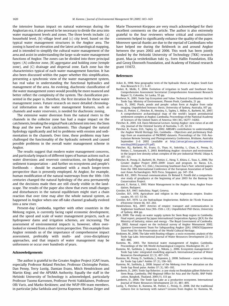
The sedimentation and erosion processes in the Siem Reapchannel have been modelled to simulate the erosion rates in thechannel. Based on the model simulations, described in more detailin Lustig et al. (2008), the channel of the Siem Reap has had ratherhigh erosion just downstream from its junction with the Puok River,to some 6 m below its original level (Fig. 6). The ground level isbased on the 50 m resolution digital elevation model (MekongRiver Commission, 2005) and TOPSAR elevation model (Fletcheret al., 2002). The original level of the channel bed is estimated to bearound 2 m below that, derived from the typical dimensions of thechannels in the area (see Section 3.1). About 15 km downstreamfrom this junction the channel has been eroded around 5 m belowthe estimated original channel bed, based on the simulation, whilethere is little or no erosion at Siem Reap town, 25–30 km down-stream from the junction (Fig. 6). The results of the modellingcorrespond to these measured bed levels rather well (Fig. 6),although a denser set of measurements would enable a more reli-able comparison.
Model results (Fig. 6) therefore, suggest that the artificialchannel has eroded along its upper part and accreted in its lowerpart downstream of Siem Reap town, so that its stream power issimilar to that of other watercourses on the alluvial fan. If thestream power has now dropped to that of the other watercoursesmost of the down-cutting should have ceased (Lustig et al., 2008).Thus, the extensive modifications of the natural watercourseswould have led to severe problems with erosion and sedimentationin the artificial channels. Down-cutting of the channels may alsohave led to difficulties in diverting water to the baray, the bottom ofwhich were at ground level (see Section 3.1).
Moreover, the possible extensive forest clearance over the entireAngkor plain, that stands in a vast expanse of rice fields (Evanset al., 2007), may have had an impact on the sediments transportedinto channels and also the hydrology of the area. With the limitedinformation available, however, no comprehensive conclusions ofthe issue can be drawn.
5. Discussion
Hydrological data for the Angkor region is limited due to therecent turbulent history of Cambodia, and therefore the analysis ofthe area’s present-day hydrology is not comprehensive. However,the available information is enough to begin to understand thedynamics of the present-day natural hydrology. MRCS/WUP-FIN(2006), for example, provides a detailed water balance analysis ona larger scale based on the available data of Tonle Sap Lake and itscatchments. However, the rainfall or other hydrometeorologicalconditions during the Angkorian era, and how these varied duringthat period, are not known. The present hydrological conditionsmust therefore be regarded as only an approximation of theconditions occurring during the medieval period.
The division of the Angkor area into water management zones,based on elevation, simplifies the complex system and allows aninterpretation of its functional logic. It may, however, provide anoverly simplistic picture of a system that was created over manyhundreds of years, possibly to perform various functions. Further-more, the zoning presented here may force the system into cate-gories that have meaning for us as modern observers but may notreflect the intentions of those who created it. Zoning based exclu-sively on elevation may also lead to the misclassification of infra-structure. For example the channel/road leading NW from the WestBaray, located in the aggregator zone, was presumably created to‘collect’ rather than store water, and move it to the SE (i.e. across theslope). Probably a combined classification, based on the elevationand presumed function of infrastructure, would be a more accurateway to define the zones. The zoning is based on the principal, large-scale, water management function(s) of each area, and there has
0 [km]
5
1015
20
25
30
35
5
10
15
20
25
30
35
40
0 5 10 15 20 25 30 35Distance from Puok River [km]
Elevatio
o
f th
e g
ro
un
d su
rface [m
]
Modelled channel bedMeasured bed levels
Est. original channel bed
Ground level
Fig. 6. The result of mathematical modelling of the down-cutting of the Siem Reap Channel. The dotted line is the original long section inferred for the bottom of the channel, whilethe solid one is the bottom of the channel after it stabilises (updated and modified from Lustig et al., 2008).
M. Kummu / Journal of Environmental Management 90 (2009) 1413–1421 1419
most likely been significant variation in water management func-tion(s) at a smaller scale within the zones, as the study of watermanagement levels already suggests.
The classification is synchronic and reflects the palimpsest thatwe are able to see today, based on the recent archaeologicalmapping and elevation, being a transparent and explicit method toclassify the zones. It fails, however, to show how the systemevolved with time. Possibly an evolving, diachronic classification ofthe water management zones would be more nuanced and wouldbetter reflect the complexity of the system, following e.g. Groslier’s(1979) diachronic view of its evolution. Detailed chronologicalinformation on the water-related features is not yet complete,however. Despite the shortcomings in the zoning discussed above,it does help to understand the large-scale water managementfunctions in the area. To summarise, the preliminary zoning pre-sented here should be seen as a first step that should be developedand enhanced with more detailed information of the system’sdevelopment over time.
The mathematical model used to estimate the erosion rate alongthe present Siem Reap River is based on many assumptions; forexample, that the original channel bed was around 2 m below theground surface. This is based on the typical dimensions of thehuman-made channels in Angkor but it is not certain whether theoriginal channel conformed to this. Moreover, the Siem Reapchannel was most probably built in two or more phases and thus, toconduct more reliable modelling, these different phases should bemodelled separately. This remains a part of the proposed futurework.
The human impact on natural watershed boundaries anderosion rates in human built channels are presented in the paper.The chronology for those alterations is, unfortunately, still uncer-tain. To increase understanding of the time sequence of those
changes, multidisciplinary research is needed where, for example,hydraulic, hydrological, sedimentological, geomorphological,archaeological, historical, palaeontological, and geoinformaticresearch are combined. Examples of this approach can be found inthe recent literature (e.g. Fletcher et al., 2003, 2006; Penny et al.,2006, 2007a,b).
6. Conclusions
The monsoons dominate the climate conditions in the Angkorarea. This led to the development of a systematic and extensivewater management network in the city of Angkor over hundreds ofyears, and which probably served multiple functions (e.g. a storefor water for the dry seasons, or the mitigation of wet-seasonfloods). This paper describes the present-day hydrology and mainwater sources in the Angkor area, specifically, natural rivers,groundwater and the Tonle Sap Lake. The article aims to describehow water management impacted on these natural sources ofwater during the Angkorian era.
The location of Angkor was, from a water management point ofview, very convenient for many reasons. Firstly, groundwater wasclose to the surface throughout the year. Secondly, Tonle Sap Lakeoffered an excellent transport link to the riparian provinces and theMekong River and, at the same time, secured part of the food supplyand maintained a fertile floodplain to cultivate rice. Thirdly, naturalrivers originating in the Kulen Hills meandered across the plain. Adrawback was the long dry season for which water needed to bestored. Therefore the Angkorian engineers built an extensive watermanagement network of channels and baray around and within themain temple area covering an area of approximately 1200 km2.
The study area is formed by the natural boundaries derived fromthe three present watersheds of the area covering 2885 km2. Due to
M. Kummu / Journal of Environmental Management 90 (2009) 1413–14211420
the intensive human impact on natural waterways during theAngkorian era, it also proved to be necessary to divide the area intowater management levels and zones. The three levels include: (a)household level, (b) village level and (c) city level, based on thetypical water management structures in the Angkor area. Thezoning is based on elevation and the latest archaeological mapping,and is intended to simplify the cultural water management of thearea and assist in understanding the large-scale water managementfunctions of Angkor. The zones can be divided into three principaltypes: (A) collector zone, (B) aggregator and holding zone (templezone), and (C) drainage and dispersal zone. Each zone has thecharacteristics typical of each water management function. It hasalso been discussed within the paper whether this simplification,presenting a synchronic view of the water management system,has real value in understanding the functional hydraulics andmanagement of the area. An evolving, diachronic classification ofthe water management zones would possibly be more nuanced andbetter reflect the complexity of the system. The classification pre-sented in the paper is, therefore, the first iteration for these watermanagement zones. Future research on more detailed chronolog-ical information on the water management features, such aschannels and water reservoirs, is needed for diachronic zoning.
The extensive water diversion from the natural rivers to thechannels in the collector zone has had a major impact on thecatchments, breaking the original Puok catchment into two: the SiemReap and the new Puok catchments. This changed the naturalhydrology significantly and led to problems with erosion and sedi-mentation in the channels. Over time, these problems may havechallenged the functionality of the hydraulic network and causedpossible problems in the overall water management scheme inAngkor.
The results suggest that modern water management concerns,and particularly impacts of different types of human actions such aswater diversions and reservoir constructions, on hydrology andsediment transportation – and further on ecosystems and people’slivelihoods – should be examined with a much longer-termperspective than is presently employed. At Angkor, for example,human modification of the natural waterways from the 10th–11thcenturies changed the natural hydrology of the area permanentlyand the decisions made then are still clearly visible in the land-scape. The results of the paper also show that even small changesand disturbances in the natural equilibrium might start a chainreaction that over time may alter the whole natural system, ashappened in Angkor when one off-take channel gradually evolvedinto a new river.
Present-day Cambodia, together with other countries in theMekong region, is currently facing rapid economic development,and the speed and scale of water management projects, such ashydropower dams and irrigation schemes, are increasing. Theassessment of environmental impacts is, however, often over-looked or viewed from a short-term perspective. This example fromAngkor reminds us of the importance of comprehensive impactassessment, preferably with multi- and cross-disciplinaryapproaches, and that impacts of water management may beunforeseen or occur over hundreds of years.
Acknowledgements
The author is grateful to the Greater Angkor Project (GAP) team,especially Professor Roland Fletcher, Professor Christophe Pottier,Dan Penny, Terry Lustig, Damian Evans, Mitch Hendrickson andMartin King; and the APSARA Authority. Equally the staff in theHelsinki University of Technology is acknowledged, particularlyProfessor Tuomo Karvonen, Professor Pertti Vakkilainen, ProfessorOlli Varis, and Marko Keskinen; and the WUP-FIN team members,in particular Juha Sarkkula and Jorma Koponen. Bastian Zeiger and
Marie Thouvenot-Korppoo are very much acknowledged for theirexcellent comments on the article. The author is also extremelygrateful to the four reviewers whose critical and constructivecomments helped to significantly enhance the quality of the paper.Moreover special thanks are due to the myriad of Cambodians whohave helped me during the fieldwork in and around Angkorbetween the years 2002 and 2006. This work has been jointlyfunded by the Helsinki University of Technology (TKK) researchgrant, Maa-ja vesitekniikan tuki ry., Sven Hallin Foundation, Ellaand Georg Ehnrooth Foundation, and Academy of Finland researchgrant 111672.
References
Acker, R., 1998. New geographic tests of the hydraulic thesis at Angkor. South EastAsia Research 6 (1), 5–47.
Barker, R., Molle, F., 2004. Evolution of irrigation in South and Southeast Asia.Comprehensive Assessment Secretariat (Comprehensive Assessment ResearchReport 5), Colombo, Sri Lanka, 55 pp.
Bonheur, N., 2001. Tonle Sap Ecosystem and Value. Technical Coordination Unit forTonle Sap. Ministry of Environment, Phnom Penh, Cambodia, 21 pp.
Evans, D., 2002. Pixels, ponds and people: urban form at Angkor from radarimaging. Unpublished honours thesis, University of Sydney, Australia, 107 pp.
Evans, D., Pottier, C., Fletcher, R., Hensley, S., Tapley, I., Milne, A., Barbetti, M., 2007.A comprehensive archaeological map of the world’s largest preindustrialsettlement complex at Angkor, Cambodia. Proceedings of the National Academyof Sciences of the United States of America 104 (36), 14277–14282.
Fletcher, R., 2001. A.R. Davis Memorial Lecture. Seeing Angkor: new views of an oldcity. Journal of the Oriental Society of Australia, 1–25. 32-33.
Fletcher, R., Evans, D.H., Tapley, I.J., 2002. AIRSAR’s contribution to understandingthe Angkor World Heritage Site, Cambodia – Objectives and preliminary find-ings from an examination of PACRIM2 datasets. Proceedings of the 11th Aus-tralasian Remote Sensing and Photogrammetry Conference, Brisbane, AustraliaSeptember 2–6 2002 (available at http://airsar.jpl.nasa.gov/documents/worshop2002/papers/P1.pdf).
Fletcher, R.J., Barbetti, M., Evans, D., Than, H., Sokrithy, I., Chan, K., Penny, D.,Pottier, C., Somaneath, T., 2003. Redefining Angkor: structure and environmentin the largest low density urban complex of the pre-industrial World. Udaya 4,107–121.
Fletcher, R., Penny, D., Barbetti, M., Pottier, C., Heng, T., Khieu, C., Tous, S., 2006. TheGreater Angkor Project 2005–2009: issues and program. In: Bacus, E.A.,Glover, I.C., Pigott, V.C. (Eds.), Uncovering Southeast Asia’s Past: selected papersfrom the 10th International Conference of the European Association of South-east Asian Archaeologists. NUS Press, Singapore, pp. 347–354.
Friedli, R.E., 2003. Personal communication. Dr Roland E. Friedli did a comprehen-sive study of geophysics at the beginning of year 2003 for the Banteay SreiConservation Project.
Garami, F., Kertai, I., 1993. Water Management in the Angkor Area. Angkor Foun-dation, Budapest.
Groslier, B.P., 1967. Indochina. Nagel, Geneva.Groslier, B.P., 1974. Agriculture and religion in the Angkorean empire. Etudes-
rurales, 95–117. 53-56.Groslier, B.P., 1979. La cite hydraulique Angkorienne. Bulletin de l’Ecole Francaise
d’Extreme Orient 66, 161–202.Hendrickson, M.J., 2007. Arteries of empire: transport and communication in
Angkorian Southeast Asia (9th–15th c. CE). Unpublished PhD thesis, Universityof Sydney, 404 pp.
JICA, 2000. The study on water supply system for Siem Reap region in Cambodia.Final report, prepared by Japan International Cooperation Agency (JICA) for theMinistry of Industry, mines and energy - The Royal Government of Cambodia.
JSA, 2002. Annual report on the technical survey of Angkor Monument 2002.Japanese Government Team For Safeguarding Angkor (JSA). UNESCO/JapaneseTrust Fund for the Preservation of the World Cultural Heritage.
Keskinen, M., 2006. The lake with floating villages: a socio-economic analysis of theTonle Sap Lake. International Journal of Water Resources Development 22 (3),463–480.
Kummu, M., 2003. The historical water management of Angkor, Cambodia.Proceedings of the 5th World Archaeological Congress, Washington DC, 27.
Kummu, M., Sarkkula, J., Koponen, J., Nikula, J., 2006. Ecosystem management ofTonle Sap Lake: integrated modelling approach. International Journal of WaterResources Development 22 (3), 497–519.
Kummu, M., Penny, D., Sarkkula, J., Koponen, J., 2008. Sediment – curse or blessingfor Tonle Sap Lake? Ambio 37 (3), 158–163.
Kummu, M., Sarkkula, J., 2008. Impact of the Mekong river flow alteration on theTonle Sap flood pulse. Ambio 37 (3), 185–192.
Lamberts, D., 2001. Tonle Sap fisheries: a case study on floodplain gillnet fisheries inSiem Reap, Cambodia. FAO Regional Office for Asia and the Pacific. RAP Publi-cation, Bangkok, Thailand, 2001/11, 133 pp.
Lamberts, D., 2006. The Tonle Sap Lake as a productive ecosystem. InternationalJournal of Water Resources Development 22 (3), 481–495.
Lustig, T., Fletcher, R., Kummu, M., Pottier, C., Penny, D., 2008. Did the traditionalcultures live in harmony with nature? Lessons from Angkor. In: Kummu, M.,

M. Kummu / Journal of Environmental Management 90 (2009) 1413–1421 1421
Keskinen, M., Varis, O. (Eds.), Modern Myths of the Mekong – A Critical Review ofWater and Development Concepts, Principles and Policies. Water and Develop-ment Publications, Helsinki University of Technology, Finland, pp. 81–94.
Mekong River Commission, 2005. Databases of Mekong River Commission. MekongRiver Commission (MRC), Vientiane, Lao PDR (metadata available at http://www.mrcmekong.org/spatial/data_catalog.htm.
MRCS/WUP-FIN, 2003. Final Report. WUP-FIN Phase I – Modelling Tonle Sap forenvironmental impact assessment and management support. Mekong RiverCommission and Finnish Environment Institute Consultancy Consortium,Phnom Penh, Cambodia, 107 pp.
MRCS/WUP-FIN, 2006. Technical Paper No.5 – Tonle Sap Lake water balancecalculations, WUP-FIN Phase II – Hydrological, environmental and socio-economic modelling tools for the Lower Mekong Basin impact assessment.Mekong River Commission and Finnish Environment Institute ConsultancyConsortium, Vientiane, Lao PDR, 32 pp.
Penny, D., Pottier, C., Fletcher, R.J., Barbetti, M.F., Fink, D., Hua, Q., 2006. Vegetationand land-use at Angkor, Cambodia: a dated pollen sequence from the Bakongtemple moat. Antiquity 80 (309), 599–614.
Penny, D., Hua, Q., Pottier, C., Fletcher, R., Barbetti, M., 2007a. The use of AMS 14Cdating to explore issues of occupation and demise at the medieval city ofAngkor, Cambodia. Nuclear Instruments & Methods in Physics Research SectionB 259, 338–394.
Penny, D., Pottier, C., Kummu, M., Fletcher, R., Zoppi, U., Barbetti, M., Tous, 2007b.Hydrological history of the West Baray, Angkor, revealed through palynologicalanalysis of sediments from the West Mebon. Bulletin de l’Ecole Françaised’Extreme-Orient 92, 497–521.
Pottier, C., 1999. Carte archeologique de la region d’Angkor. Zone sud. PhD thesis,Universite Paris III – Sorbonne Nouvelle (UFR Orient et Monde Arabe).
Poulsen, A.F., Poeu, O., Viravong, S., Suntornratana, U., Thung, N.T., 2002. Fishmigrations of the Lower Mekong River Basin: implications for development,planning and environmental management. MRC Technical Paper, Mekong RiverCommission, Phnom Penh, 62 pp.
Rainboth, W.J., 1996. FAO Species Identification Field Guide for Fishery Purposes.Fishes of the Cambodian Mekong. Food and Agriculture Organization of theUnited Nations (FAO), Rome, Italy, 265 pp.
Sarkkula, J., Baran, E., Chheng, P., Keskinen, M., Koponen, J., Kummu, M., 2005. TonleSap pulsing system and fisheries productivity. Verhandlungen des Inter-nationalen Vereins fur Limnologie 29 (2), 1099–1102.
Song, C.C.S., Yang, C.T., 1980. Minimum stream power: theory. Journal of theHydraulics Division. American Society of Civil Engineers 106 (HY9), 1477–1478.
van Liere, W.J., 1980. Traditional water management in the Lower Mekong Basin.World Archaeology 11 (3), 265–280.
van Liere, W.J., 1982. Was Angkor a hydraulic society? Ruam Botkwan Prawarisat(Recueil d’articles d’histoire), 4. Silpakorn University, Bangkok, pp. 36-48.