mccarran international airport · pdf filemccarran international airport las vegas, nevada...
TRANSCRIPT
McCarran International Airport Las Vegas, Nevada Airport Traffic Control Tower Siting Study Final Siting Report
May 2005 Prepared by: Darren Brinker, ANI-540
Completed: 5/11/2005

McCarran International Airport – Airport Traffic Control Tower Siting Study Final Siting Report
EXECUTIVE SUMMARY This report documents the study to determine the optimum location and height for a new airport traffic control tower (ATCT) facility at McCarran International Airport (LAS) in Las Vegas, Nevada. The study, conducted by the Kansas City NAS Implementation Center (ANI-540), with extensive participation by the Clark County Department of Aviation (DOA), as well as the local and regional Federal Aviation Administration (FAA) offices, has established a recommendation for the location and height of a new ATCT. This report presents background information concerning the need for a new control tower at LAS, a discussion of the siting and evaluation criteria for the new tower, an overview of all potential sites considered, a detailed evaluation of the primary siting options, and the final conclusions and recommendations. It is intended that the information contained in this report will document the actions of the Siting Team, the siting study process, and the final conclusions and recommendations. The need for a new ATCT at LAS results from the size, age, location and height of the existing tower. The existing tower was constructed and commissioned in the early 1980’s. It is centrally located between the east-west runways and the north-south runways, and has a control cab floor height of approximately 180 feet above ground level (AGL). Over the last 20 years, the number of Air Traffic positions in the control cab has increased from six to 14 to accommodate the increase in air traffic over the same period. Passenger traffic at McCarran Airport has increased from 16.3 million in 1988 to over 40 million in 2004. Due to the air traffic growth and the general development of McCarran Airport, the existing tower is constrained in its ability to accommodate the number of air traffic controllers and the equipment needed to serve air traffic control at the airport. Further, the existing tower does not currently provide controllers with optimum airfield viewing capability due to airport. In general, the existing airport traffic control tower has reached its life expectancy. A budget item and justification for a new ATCT at Las Vegas were submitted as part of the FY02 FAA budget process. The justification cited the size and height inadequacies of the existing control cab as the main reasons for a new control tower; however, an assumption was included that a new ATCT could be constructed on the existing ATCT/TRACON site, which would allow for the utilization of the existing administrative space for the new ATCT. The associated budget estimate was $12.8M for construction and approximately $400K for electronics installation. The siting study for a new ATCT site began in June of 2003 with the identification of six potential sites for initial evaluation. Of the six sites, three were located on the existing ATCT/TRACON plot (Site A, Site B, and Site C) in an attempt to comply with the FY02 budget justification; however, the remaining three were scattered at various locations around the airport (Terminal B, Sunset Road, and Russell Road) because the Siting Team wanted to be confident that all potential siting options were considered regardless of their proximity to the existing ATCT/TRACON site.
Completed: 5/11/2005 ES-1

McCarran International Airport – Airport Traffic Control Tower Siting Study Final Siting Report
Early in the siting process, Terminal Approach Control Procedures (TERPS) calculations were performed to determine the maximum allowable building height at each of the six potential siting locations. At the same time, the Airways Facilities Technical Integration Laboratory (AFTIL) in Atlantic City, New Jersey generated a three-dimensional model/simulation of McCarran Airport. The TERPS results, along with the AFTIL model/simulation were used to evaluate viewing conditions from various cab heights at all of the potential sites. The model/simulation was also used to assess the shadowing impacts of the new ATCT during the construction phase while viewing from the existing control cab. The shadowing impacts of the old ATCT while viewing from the various new control cab locations were also evaluated. The use of the AFTIL model also made it possible to evaluate the effects of existing and proposed airport development. The Siting Team, which consisted of representatives of Air Traffic, Airway Facilities, NATCA, PASS, ANI, and the DOA, visited the AFTIL in November of 2003. By utilizing the AFTIL model/simulation, two sites (Site A and Site B on the existing ATCT/TRACON site) were eliminated almost immediately because of the shadowing effects created by the new ATCT structure when viewing from the existing control cab during construction. The remaining four sites were evaluated from various control cab heights to determine the optimal viewing elevations. Shortly after returning from the AFTIL trip, the DOA eliminated one of the remaining sites (Russell Road Site) because of planned road construction and development in the site area. To compensate for the lost site, the DOA identified a replacement site near the future Terminal 3 building. The “Terminal 3 Site” proposed by the DOA actually consisted of two sites, one on the east side of Kelly Lane and one on the west side of Kelly Lane, and both were located relatively close to the Russell Road Site. Since the proposed site on the east side of Kelly Lane was a much larger site, the Siting Team focused its efforts on the eastern property because it offered increased setback distances for security requirements, and additional space for possible future expansion of the Base Building. Each of the remaining primary siting options (Site C on the existing ATCT/TRACON site, Sunset Road, Terminal B, and the new Terminal 3) were analyzed and evaluated in detail, following the procedures identified in FAA Order 6480.4, Airport Traffic Control Tower Siting Criteria, as well as new criteria established by the Air Traffic Organization (ATO). The analyses involved studies of viewing capability from each of the sites, and included an evaluation of each siting option considering the criteria contained in FAA Order 6480.4. The results of these studies and analyses have been documented in this Final Siting Report. After continuing the siting process through the early part of 2004, two developments changed the siting results. First of all, the DOA eliminated the Sunset Road Site from consideration. It was a privately owned parcel of land, and the DOA was initially willing to acquire it and lease it to FAA for the new ATCT. During the time the site was first identified until early 2004, real estate prices in the Las Vegas Valley increased considerably, and the DOA could no longer justify acquiring the property for FAA. Secondly, the DOA informed FAA that the Terminal 3 building design had been revised,
Completed: 5/11/2005 ES-2
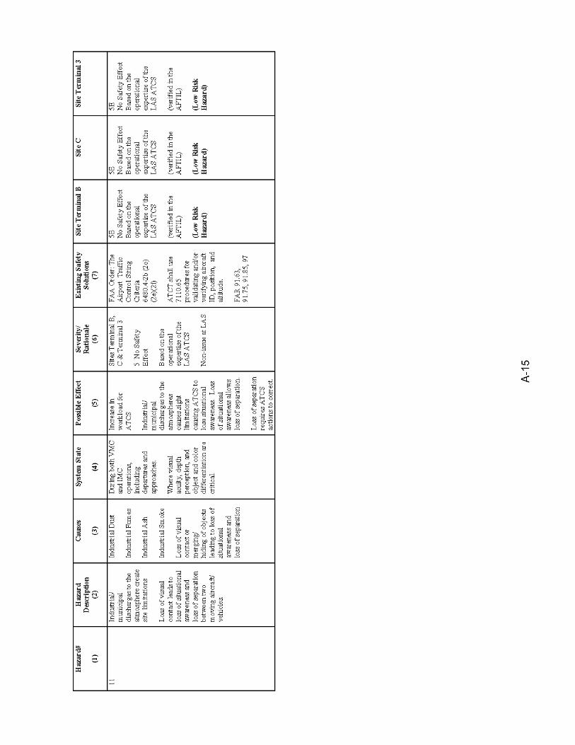
McCarran International Airport – Airport Traffic Control Tower Siting Study Final Siting Report
and that the structure would actually have to be moved further to the west, which placed it on the eastern half of the preferred Terminal 3 Site (east side of Kelly Lane). Because of the design changes, the usable size of the Terminal 3 Site located on the east side of Kelly Lane was decreased dramatically. At the same time, however, the DOA stated that the Terminal 3 Site on the west side of Kelly Lane could be enlarged from the original 1.5 acres to around 3.5 acres. As a result, the Siting Team shifted its focus to the Terminal 3 Site on the west side of Kelly Lane. A small contingent of the FAA Siting Team consisting of Air Traffic and ANI returned to the AFTIL model/simulation in late July of 2004 to assess the impacts of moving the ATCT to the west side of Kelly Lane. As expected, the line-of-sight viewing of the airport and movement areas improved as the ATCT was moved further west. In fact, the final determination was to construct the new ATCT as far west on the site as possible to provide improved visibility to Taxiway D behind Terminal 2 and decrease the shadowing impact of the existing ATCT when viewing from the new cab. In addition to the viewing improvements, the larger site on the west side of Kelly Lane potentially offered increased security setback distances from the public streets, and would abut the AOA on the east and south, which inherently would offer increased security for the facility. Based on the analyses of this study, the results of the FAA airspace and TERPS evaluations, information and feedback obtained from the AFTIL model/simulation, and a comparison of advantages and disadvantages of all of the primary siting options, the Terminal 3 Site on the west side of Kelly Lane was selected as the preferred siting option for the new ATCT. The Terminal B site was eliminated for a variety of reasons including, its proximity to a TSA baggage screening facility, restricted AOA access during construction and after commissioning, no on-site parking for FAA personnel, underground fuel lines in the vicinity, the likelihood of aircraft noise and exhaust fumes impacting FAA operations, and the general dissatisfaction with the site by several DOA offices. Site C was eliminated because of the ramifications associated with a severe lack of setback distance from public streets, the major impact to existing FAA employee parking, increased risk to existing operations during the construction phase, potential risk to the passenger tram that bisects the existing FAA site, and the lack of any future expansion capability. In September of 2004, ANI briefed the FAA Western Pacific (AWP) Region Office of the conclusions and recommendations outlined in the Siting Report. ANI identified the Terminal 3 site on the west side of Kelly Lane, located in the southwest quadrant of the intersection of Kelly Lane and Russell Road, as the final selection. ANI informed the AWP Regional Office that the new ATCT could be constructed with a cab floor height of 289 feet AGL, providing a viewing height of 294 feet AGL, corresponding to an elevation of 2,354 feet above mean sea level (AMSL). The top of the tower structure would be approximately 324 feet AGL, corresponding to an elevation of 2,384 feet AMSL. At $50K per vertical foot of control tower (to the cab floor), the ATCT cost was estimated at $14.5M. The associated 7,500 square-foot administrative Base Building, using $250 per square foot, was estimated to cost approximately $1.875M. Because full exterior security setbacks could not be attained at the Terminal 3 Site, a 10% contingency was added to the
Completed: 5/11/2005 ES-3
McCarran International Airport – Airport Traffic Control Tower Siting Study Final Siting Report
construction cost estimate to account for some blast hardening of both structures. With the contingency, the initial cost estimate for the ATCT and Base Building was about $18M. Shortly after the initial Siting Report was finalized, the DOA notified FAA that a large water main was located on the southern portion of the Terminal 3 Site. The location of the water line, if left in-place, would impact the anticipated location of the ATCT and Base Building on the Terminal 3 Site, and would result in reduced security setback distances and increased blast-hardening costs. After some preliminary investigation, the DOA determined that the water line could be relocated off of the site at a cost of approximately $750K; however, it has not been determined whether FAA or DOA will pay for the relocation. Subsequently, in October of 2004 the local FAA Air Traffic personnel noticed a new building construction project on the north end of the Terminal 2 structure. The facility was being constructed by the DOA for the Transportation Security Administration (TSA), and will be used as a baggage screening facility for Terminal 2. Unfortunately, due to the height and location of the new TSA baggage screening facility, line-of-sight visibility to Taxiway D behind Terminal 2 was severely impacted from the proposed new ATCT location with a cab floor elevation of 289 feet AGL. The Siting Team returned to the AFTIL in November of 2004 to complete the Safety Management System (SMS) exercise for the ATCT siting process, and to assess the impacts of the new TSA baggage screening facility. To establish an acceptable line-of-sight to Taxiway D behind the new TSA building, the ATCT cab floor had to be raised approximately 48 feet to 337 feet AGL. With a cab floor at 337 feet AGL, the overall structure height increased to approximately 372 feet AGL. The cost impact for the additional 48 feet was estimated at $3.0M. As a result, ANI re-evaluated the primary siting options (Site C and Terminal B), and coordinated with the DOA to identify any possible new sites elsewhere on the airport. The Site C location, in the parking lot of the existing ATCT facility, was still deemed to be an unacceptable alternative because of the severe lack of security setback distances, impacts to the operational facility during construction, impacts to employee parking, and the conflict between seismic and blast requirements. Due to another planned DOA construction project to connect the Terminal 1 B Gates and C Gates with a sky bridge, the Terminal B Site was no longer available. The DOA actually identified one new possible site; however, it was quickly eliminated because the site is currently being used as a storm drainage detention pond and would require immense amounts of fill to accommodate construction. Also, site access would be challenging, the existing drainage pipes would have to be relocated, and ductbank access would likely be difficult and expensive. Consequently, the only viable conclusion is to construct the new ATCT on the Terminal 3 Site on the west side of Kelly Lane. The new ATCT will be constructed with a cab floor height of 337 feet above ground level (AGL), providing a viewing height of 342 feet AGL, corresponding to an elevation of 2,402 feet above mean sea level (AMSL). The top of the tower structure would be approximately 372 feet AGL, corresponding to an elevation of 2,432 feet AMSL.
Completed: 5/11/2005 ES-4

McCarran International Airport – Airport Traffic Control Tower Siting Study Final Siting Report
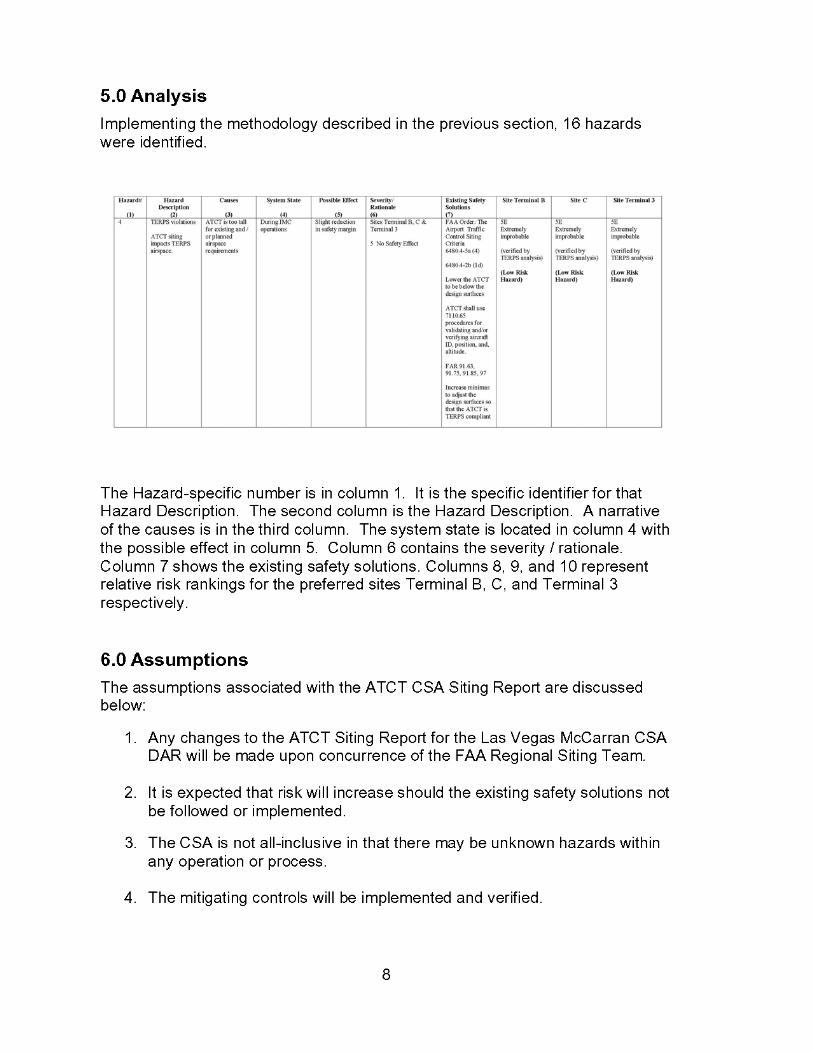
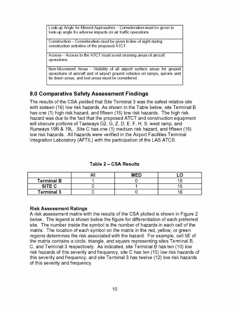
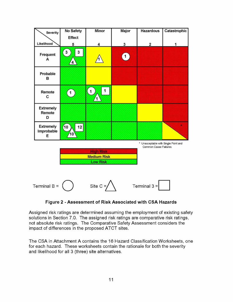
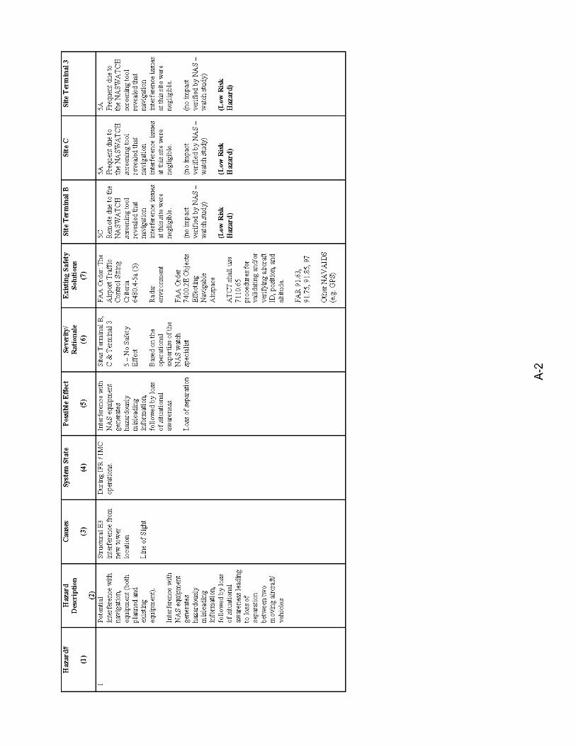
Construction of the new ATCT at the proposed Terminal 3 Site, and at the proposed height of 372 feet AGL, will not affect any approach, or missed approach surfaces and will not affect the circling minimum of 3,020 feet AMSL for McCarran Airport. Additionally, the tower and base building facility is not expected to impact any electronic equipment, navigational aids, or radar facilities. A Comparative Safety Assessment (CSA) has been completed for the LAS ATCT siting effort. The Safety Risk Management Document, which summarizes the results of the CSA, is included in Appendix 6. The purpose of the CSA was to apply the Safety Risk Management (SRM) process, as defined in the FAA Safety Management System (SMS) Manual, to the ATCT siting process for McCarran Airport to ensure it is compliant with the goals and objectives of the FAA SMS Manual. The results of the CSA coincide with the findings of the Final Siting Report in that the Terminal 3 Site is the most favorable siting option. The Terminal 3 Site presents the most favorable safety profile of all three primary siting options, and has the lowest relative safety risk ranking. This study was conducted by the FAA in association with the Clark County Department of Aviation. The Las Vegas Airway Facilities and Air Traffic personnel, Western Pacific (AWP) Regional Office personnel, Sierra Nevada SMO personnel, and engineering staff from the Kansas City Implementation Branch participated in the study.
Completed: 5/11/2005 ES-5


McCarran International Airport – Airport Traffic Control Tower Siting Study Final Siting Report
TABLE OF CONTENTS INTRODUCTION 1. BACKGROUND INFORMATION
1.1 General Information on McCarran International Airport 1.2 Need for New Airport Traffic Control Tower 1.3 Overall Project Scope 1.4 Historical Ceiling Height Information 1.5 Siting Study Scope
2. CRITERIA FOR SITE IDENTIFICATION AND EVALUATION
2.1 Siting Criteria from FAA Order 6480.4, Airport Traffic Control Tower Siting Criteria 2.2 Other Siting Considerations 2.3 Summary of Siting Criteria and Considerations
3. INITIAL SITE IDENTIFICATION AND ANALYSIS 3.1 Initial Site Identification 3.2 Analysis of Initial Sites 3.3 Summary Comparison of Initial Sites 3.4 Identification of Primary Siting Options 3.5 Elimination of Unfavorable Sites 3.6 Airfield Viewing/Shadow Analysis of Primary Siting Options
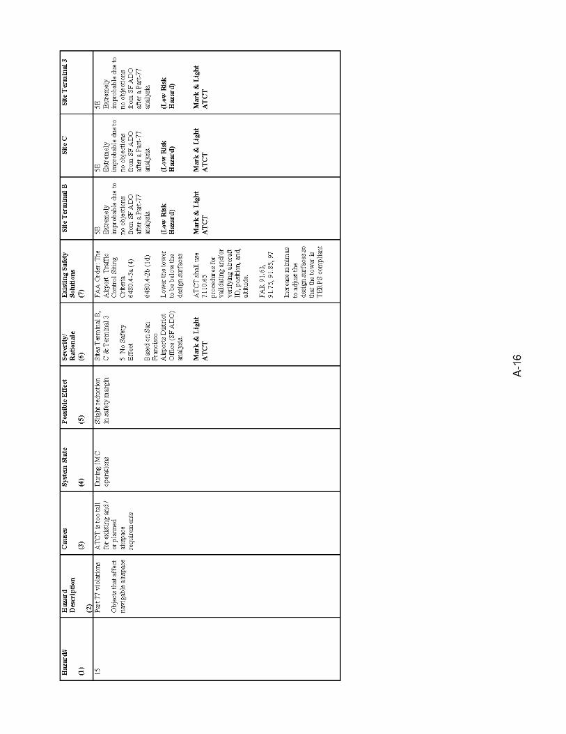
4. EVALUATION OF PRIMARY SITING OPTIONS 4.1 Site C 4.2 Terminal 3 Site 4.3 Terminal B Site
5. COMPARISON OF PRIMARY SITING OPTIONS 5.1 Summary of Advantages and Disadvantages of Primary Siting Options 5.2 Summary Comparison of Primary Siting Options 5.3 Summary Cost Comparison of Primary Siting Options 5.4 Summary Comparison of Life Cycle Costs
6. CONCLUSIONS AND RECOMMENDATIONS
6.1 Initial Conclusions 6.2 Final Conclusions and Recommendations
Completed: 5/11/2005 i
McCarran International Airport – Airport Traffic Control Tower Siting Study Final Siting Report
TABLE OF CONTENTS (continued) APPENDICIES Appendix 1 List of Contacts Appendix 2 Shadow Diagrams for Existing ATCT and Primary Siting Options Appendix 3 Jacobs Engineering Construction Feasibility Study for Site C Appendix 4 Coordination Letters Appendix 5 Airspace Study Determination Letters Appendix 6 Safety Management System (SMS) Report LIST OF FIGURES Figure 1 Vicinity Map and Airport Layout Figure 2 Initial Site Locations Figure 3 Existing ATCT Site Showing Locations of Sites A, B, and C Figure 4 Revised Terminal 3 Site (West Side of Kelly Lane) LIST OF TABLES Table 1 Minimum Viewing Elevations and Heights for Minimum 35-Minute Angle Table 2 Maximum Allowable Tower Heights Table 3 Summary Comparison of Preliminary Siting Options Table 4 Summary Comparison of Primary Siting Options Table 5 Summary Cost Comparison of Primary Siting Options
Completed: 5/11/2005 ii


McCarran International Airport – Airport Traffic Control Tower Siting Study Final Siting Report
INTRODUCTION The Federal Aviation Administration (FAA) is undertaking a study to determine the most suitable location and height for a new Airport Traffic Control Tower (ATCT) for McCarran International Airport (LAS) in Las Vegas, Nevada. The Kansas City National Airspace System (NAS) Implementation Center’s Terminal Platform (ANI-540) is performing the siting study and will be responsible for the overall engineering and construction activities for the new LAS ATCT via a Resource Sharing Agreement (RSA) with the terminal platform from the Los Angeles NAS Implementation Center (ANI-940). This report documents the analyses and evaluations conducted during the siting study. It provides background information on McCarran Airport and the need for a new control tower, a discussion of the siting and evaluation criteria, an overview of all sites considered, and an evaluation of the primary siting options. It also presents conclusions of the siting study, and a recommendation for the location and height for the new ATCT. Criteria used in the analyses and evaluations are based primarily on FAA Order 6480.4, Airport Traffic Control Tower Siting Criteria, and FAA Order 6480.7d, Airport Traffic Control Tower and Terminal Radar Approach Control Facility Design Guidelines. These orders were supplemented by FAA Federal Aviation Regulations (F.A.R’s), Advisory Circulars (AC’s), and other documents from which airspace and navigational aide (NAVAID) clearance and obstruction criteria where established. In addition, a variety of other considerations not cited specifically in FAA documents were deemed to be relevant to the analyses of the potential siting options, and were included in the evaluations. The general methodology followed in this siting study was to first identify various areas around the airport where a new ATCT could potentially be located, and then to identify specific potential site locations in these areas with respect to airfield horizontal clearance and separation standards and airspace clearance restrictions. Once the potential sites were identified, airfield viewing conditions based on line-of-sight criteria were investigated. This work led to the identification of the most feasible sites. These most feasible sites were then evaluated considering the variety of siting criteria and factors. The basic steps taken in the evaluation of each tower site were:
♦ Determination of minimum tower height to provide a minimum 35-minute viewing angle to existing and future runway surfaces.
♦ Determination of maximum possible tower height considering existing and future airspace clearance requirements.
♦ Determination of minimum tower height required to provide clear viewing to nearest taxiway safety area edge
♦ Determination of required tower height at each site, based on highest of 35-minute viewing angle height requirements and taxiway safety area viewing height
Completed: 5/11/2005 1
McCarran International Airport – Airport Traffic Control Tower Siting Study Final Siting Report
♦ Analysis of sight obstructions caused by buildings.
♦ Evaluation of the most feasible siting options in relation to the established siting criteria and other relevant factors.
Documentation of the analyses, evaluations, and conclusions of the siting study is contained in this report. The documentation is organized as follows: Section 1 Background Information. Background information on McCarran Airport, the
justification for a new ATCT, and the scope of the siting study. Section 2 Criteria for ATCT Site Identification and Evaluation. Overview of the criteria
and factors considered in the identification and evaluation of potential sites for a new ATCT facility.
Section 3 Initial Site Identification and Analysis. Discussion of initial sites identified for
the new ATCT, evaluation of these initial sites, and determination of the most feasible siting options based on the initial identification and evaluation.
Section 4 Evaluation of Primary Siting Options. Analyses of most feasible siting
options identified in the initial site investigations. Section 5 Comparison of Alternatives. Summary of the advantages and
disadvantages of each of the primary siting options, and comparison of the options in a qualitative fashion by means of a matrix.
Section 6 Conclusions and Recommendations. Summary of the initial conclusions of
the study, overview of FAA analysis and evaluations, and presentation of final conclusions and recommendations.
Completed: 5/11/2005 2

McCarran International Airport – Airport Traffic Control Tower Siting Study Final Siting Report
1. BACKGROUND INFORMATION 1.1 General Information on McCarran International Airport
Las Vegas McCarran International Airport (LAS) is located in Clark County approximately 5 miles south of the City of Las Vegas and east of and adjacent to the “Las Vegas Strip.” The McCarran airport site covers an area of approximately 3,000 acres. McCarran Field on South Las Vegas Boulevard was constructed and opened for service in December 1948. In March 1963, the terminal building and operations were relocated to its present day location on Paradise Road. McCarran is currently ranked the 7th busiest airport in the nation and is the 2nd busiest airport in terms of originating/destination passenger traffic. In 2003, McCarran accommodated
approximately 36.2 million passengers and 501,000 aircraft operations. The passenger total included 35.1 million domestic and 1.1 million international travelers. In 2004, McCarran is averaging an increase of approximately 6 percent in activity. The airport is owned by Clark County, Nevada and operated under the policy direction of the Board of County Commissioners, the authority of the County Manager and the management of the Director and Deputy Director of Aviation. See Figure 1 for a vicinity map and airport layout. The airport terminal facilities configuration consists of two terminals and four passenger concourses. Concourses A, B, C and D are accessible through Terminal 1. Concourse C and D passengers are shuttled to and from Terminal 1 by automated transit systems. Eight gates at Terminal 2 primarily service charter and international flights. The airfield configuration is currently comprised of four active runways with a supporting network of taxiways and taxi lanes connecting runways to aircraft parking and staging areas. The east-west parallel runways (RW 7 and 25) are situated south of Terminal 1 and the north-south set of parallel runways (RW 1 and 19) is located west of Terminal 2. Since the airport is bound on all four sides by major thoroughfares, housing subdivisions, and commercial developments, there are no plans for additional runways or runway extensions. Fixed based operators and general aviation facilities are located on the west side of the airport. Air Cargo buildings and other aviation-related facilities are located on the east side. Currently, the airport has several major projects in progress. The projects listed below, as well as others, are a part of McCarran’s $1.8 billion dollar Capital Improvements Program:
1) Expansion of Satellite “D” terminal and apron, 2) Terminal One and Two ramp rehabilitation, 3) a Consolidated “Rent-A-Car” facility, 4) a Bus Maintenance facility, 5) Taxiways Z, B, W, 6) Throat area ramp and Storm Drain improvements,
Completed: 5/11/2005 3
McCarran International Airport – Airport Traffic Control Tower Siting Study Final Siting Report
7) Taxiway C extension, 8) Concourse A and B window wall replacement and HVAC upgrade, 9) In-line Baggage Screening nodes at Terminals One and Two, 10) Relocation of Russell Road and a nearby Fire Station.
1.2 Need for New Airport Traffic Control Tower The existing ATCT was constructed in the early 1980’s and was commissioned in 1983. Activity at McCarran Airport has steadily increased over the past two decades and the existing ATCT is simply not tall enough, nor the cab large enough, to accommodate the expected increase in activity in the future. The line-of-site from the existing ATCT to several areas on the airport has been adversely impacted over the years by new construction. Visibility to the backside of Concourses A, B, and D is blocked, and aircraft moving in these areas cannot be seen from the ATCT cab. Visibility to portions of Taxiway Delta is impaired by Terminal 2 (Charter/International Concourse) as well. Future construction by the airport sponsor will further impair the line-of-sight problems at the airport. In addition to the line-of-sight concerns, the existing control cab is too small to support the existing positions and allow for future expansion. When the ATCT was commissioned over 20 years ago, there were only 6 air traffic controller positions in the cab. Due to increased air traffic at McCarran Airport, there are currently 14 positions in the 525 square-foot cab, and the available space has been utilized beyond its capacity.
1.3 Overall Project Scope Based on the rationale identified in Section 1.2 above, a project scope and justification were submitted as part of the FAA budget process for the relocation of the LAS ATCT. The solution in that budget submission recommends the construction of a new ATCT shaft and utilization of the existing Base Building/TRACON facility. However, rather than take a short-sided view and only entertain potential sites on the existing ATCT plot, the Project Team, consisting of Airway Facilities, Air Traffic, ANI, and Clark County representatives, decided to focus on the most feasible sites irregardless of their proximity to the existing Base Building/TRACON facility. This approach, although more time consuming, will allow everyone involved with the project to be certain that some potentially excellent sites were not overlooked. Critical factors such as construction costs, utility costs, and/or environmental issues can then be examined to make a final determination of whether or not a site should be eliminated from consideration. This final siting report summarizes all of the information that was gathered during the siting process, and provides a final site selection recommendation.
Completed: 5/11/2005 4
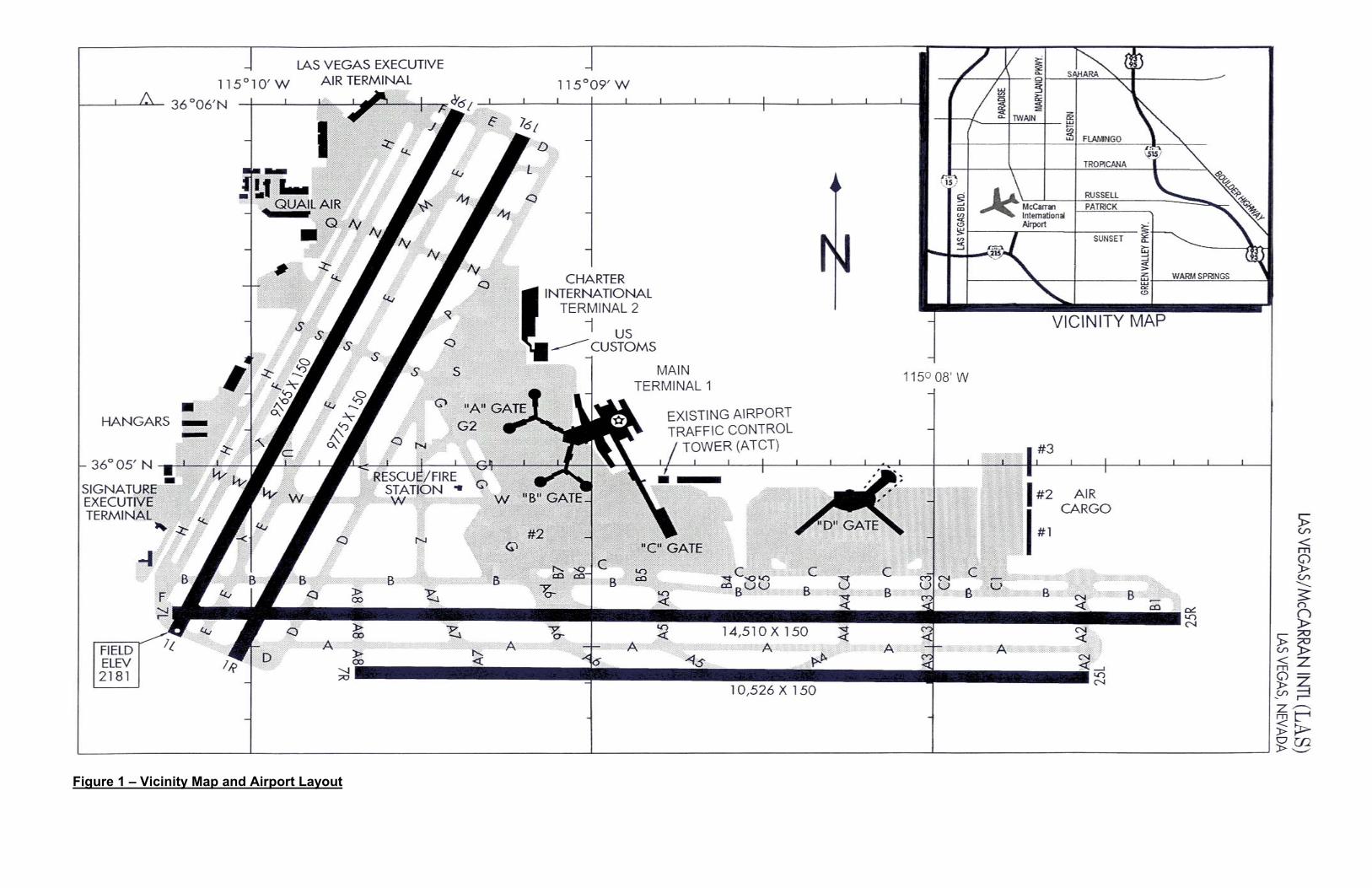
Figure 1 – Vicinity Map and Airport Layout

McCarran International Airport – Airport Traffic Control Tower Siting Study Final Siting Report
1.4 Historical Ceiling Height Information A consideration relevant to the evaluation of potential tower heights is the frequency at which a tower cab is likely to be above the weather ceiling, or to have visibility impaired by the presence of fog. Based on information obtained from the Western Regional Climate Center, Desert Research Institute, low clouds and fog are not a concern in Las Vegas, Nevada. Due to its desert location, heavy fog occurs less than 1 day per year, and generally lasts for only an hour or so. A low ceiling of 200 feet or lower is likewise very rare to the point that there is no average percent of frequency.
1.5 Siting Study Scope The siting study for a potential new LAS ATCT is focused on determining the optimum siting solution for that new tower. The siting solution consists of the facility location, the cab height, and the ability of the air traffic controllers to maximize their line-of-site to all areas of the airport. The study encompasses several tasks, including establishing siting criteria, identifying possible sites, analyzing and evaluating the sites, and developing recommendations for the new ATCT. The study considers existing and future configurations of the airport in the analysis of tower siting scenarios. It also considers other critical factors such as cost of construction, availability of utilities, and environmental issues. This study was conducted with significant input from the Clark County Aviation Department, as well as local and regional FAA staff. The product of the study is this final siting report. As noted previously in the Introduction, this report documents siting criteria, the potential sites, evaluation of potential sites, airfield viewing conditions from the potential sites, and ultimately the recommendations for the new ATCT location. The study and analysis were conducted in accordance with Federal Aviation Administration Order 6480.4, Airport Traffic Control Tower Siting Criteria, and in coordination with the Clark County Aviation Department and the FAA.
Completed: 5/11/2005 5

McCarran International Airport – Airport Traffic Control Tower Siting Study Final Siting Report
2. CRITERIA FOR SITE IDENTIFICATION AND EVALUATION Described below are the criteria and considerations that have been addressed in the siting study. The criteria and considerations are taken in part from FAA Order 6480.4, Airport Traffic Control Tower Siting Criteria. As stated in Order 6480.4, the Order “sets forth the procedures to be followed, the criteria to be used, the considerations to be made, and the methods of site evaluation and site selection.” The Order establishes a variety of siting requirements, some of which are “Mandatory” and some of which are “Non-Mandatory”. The siting requirements contained in Order 6480.4 are provided below. The mandatory and non-mandatory requirements are listed separately. In addition to the requirements defined by Order 6480.4, there are several other siting considerations and factors that are related specifically to McCarran Airport, either separate from or extensions of requirements contained in the Order. These are also described below. In establishing the criteria and considerations to be addressed in this study, the factors and issues specific to McCarran Airport have been combined with the criteria set forth in Order 6480.4. The combination defines the siting criteria and considerations that have guided this study. This combination of criteria and considerations is summarized below, following the listing of criteria contained in the Order and the discussion of other factors and considerations.
2.1 Siting Criteria from Order 6480.4, Airport Traffic Control Tower Siting Criteria 2.1.1 Mandatory Siting Requirements
a. “Maximum visibility of airborne traffic patterns must be available. Primary
consideration must be given to the local control position of operation; however, all operating positions must have this capability. A clear unobstructed view of the approach to the end of the primary instrument runway and all other active runways and landing areas should be available.” Comment: This requirement must be applied to existing runways as well as possible future runways. For the McCarran ATCT, existing Runways 01R-19L, 01L-19R, 07R-25L, and 07L-25R would be considered. Due to development around the perimeter of the airport, no future runways are planned at McCarran Airport.
b. “Complete visibility must be available to all airport surface areas utilized for movement of aircraft which are under the control of the airport traffic control tower. Primary consideration must be given to the air traffic ground control position of operation; however, all operating control positions should have this capability. A clear, unobstructed and direct view of taxiways and runways should be available.” Comment: The areas under control of the tower include the full lengths of the taxiways south and west of Terminal 1, west of Terminal 2, and the taxiways parallel to the runways.
c. “The site plot must provide sufficient area to accommodate the initial building and any planned future extensions, personnel, and facility vehicle parking, fuel storage
Completed: 5/11/2005 6
McCarran International Airport – Airport Traffic Control Tower Siting Study Final Siting Report
tanks, exterior transformers, etc., as dictated by location requirements”. Comment: One of the potential sites for a new tower at McCarran Airport will be a location in the ramp area near the B Gates of Terminal 1. For a new tower located in this area on the AOA, it would not be possible to provide personnel parking at the facility with a site at such a location.
d. “Federal Aviation Regulations, Part 77, Objects Affecting Navigable Airspace, including all amendments, must be complied with unless deviations are absolutely necessary to meet mandatory siting requirements given above.” Comment: Part 77 surfaces to be considered include approach and transitional surfaces for the existing and proposed runways. This requirement should be extended to include ILS approach and missed approach surfaces (TERPS) as well as Part 77 surfaces.
e. “The tower must not be sited where it will derogate the performance of existing or planned electronic facilities (ILS, TVOR, RTR, etc.).” Comment: The functions of communication facilities, radar facilities (particularly ASDE and ASR), and existing and proposed ILS localizers will be considered.
2.1.2 Non-Mandatory Siting Requirements
a. “Depth perception of all surface areas to be controlled should be available. This is the ability to differentiate the number and type of grouped aircraft and/or ground vehicles, and to observe their movement and position relative to the airport surface areas. Perception is enhanced where the controller’s line of sight is perpendicular or oblique, not parallel to, the line established by aircraft and/or ground vehicle movement, and where the line of sight intersects the airport surface at a vertical angle greater than 35 minutes”. Comment: Although the 35-minute vertical viewing angle is presented in the Order as a non-mandatory criterion, siting studies typically take the 35-minute angle as a minimum standard in calculating tower cab heights and in evaluating whether a tower will provide adequate perspective for controllers. In general, Air Traffic personnel often emphasize the value of perpendicular or oblique viewing of critical airport surfaces.
b. “The tower cab should be oriented to face north, or alternatively east, south, or west in that order of preference for control towers in the northern hemisphere. In areas where snow accumulates on the ground surface, a southern orientation should be avoided. Avoid orientations that will place a view of the runway approach in line with a rising or setting sun.” Comment: The existing tower at McCarran has considerable exposure to the southeast, south, west and northwest to Runways 25R and 25L, 19R and 19L.
Completed: 5/11/2005 7

McCarran International Airport – Airport Traffic Control Tower Siting Study Final Siting Report
Except for sun reflections off of the Mandalay Bay Hotel/Casino, discussions with LAS Air Traffic personnel indicated that the orientation of the existing tower cab is not a significant concern, despite the exposure to the south and west.
c. “Visibility should not be impaired by direct or indirect external light sources. Such sources may be ramp lights, parking area lights, and reflective surfaces.” Comment: In general, view from a tower into a terminal area with ramp and building lights mixed with aircraft and vehicle lights presents one of the most difficult situations for air traffic controllers. At McCarran Airport the presence of the brightly lit hotels and casinos along Las Vegas Boulevard just to the west of the airport further complicates this issue. It is safe to assume that any tower location that provides good line of site to taxiways and runways at McCarran would be affected by the hotel/casino lighting.
d. “Visibility should be available for all ground operations of aircraft and to airport ground vehicles on ramps, apron and tie-down areas, and test areas.” Comment: Generally, it is desired that a tower provide visibility of as much operational area as possible. In practice, it is often not possible to provide full visibility of ramp and apron areas, due to terminal and concourse buildings as well as aircraft fuselages and tails.
e. “Consideration must be given to local weather phenomena to preclude restrictions to visibility due to fog or ground haze.” Comment: Fog and low cloud ceilings are not of particular concern at McCarran Airport. The desert climate precludes the area from fog and low ceilings to the extent that historical data is typically not recorded.
f. “Exterior noise should be at a minimum and sites should be evaluated through a comparison of expected noise levels at each location.” Comment: Any location for the tower on the airfield could have a significant effect on noise exposure, although the existing ATCT is located within 1,000 feet of the nearest C Gates and 1,500 feet of the nearest B Gates. With the exception of the Terminal B site, all of the other potential siting locations would offer approximately the same, or increased, distance to the nearest gates.
g. “Access to the site should avoid crossing areas of aircraft operations.” Comment: The viability of this will depend on the location of the optimum tower site. A site located in the B Gate area would be accessed across the AOA. To minimize traffic across the AOA in this situation, and to preserve the maximum possible apron area for aircraft parking and servicing, parking for personnel could not be provided at the facility.
Completed: 5/11/2005 8
McCarran International Airport – Airport Traffic Control Tower Siting Study Final Siting Report
h. “Consideration should be given to planned airport expansion as shown on the airport master plan. Particular attention should be given to future construction of buildings, hangars, new or extended runways and taxiways, etc. to preclude the necessity for relocation of the control tower at a future date.” Comment: The future construction of additional D Gates, Terminal 3, and a new Ramp Control Tower will all be considered. Due to the development around the airport, there are no plans to extend the existing runways or construct new runways at McCarran Airport.
i. “The tower should be sited in an area which is relatively free of jet exhaust fumes and impairments to visibility such as industrial smoke, dust and fumes.” Comment: Jet exhaust would be a potential concern for any tower site located on or very near an aircraft parking apron. Experience with towers located on aprons, such as at Lambert International Airport in St. Louis, Missouri, has shown that jet exhaust can be drawn into the ventilation system if the system is not carefully planned and designed. Separate from aircraft and vehicle exhaust fumes, industrial smoke, dust and other fumes are not expected to be significant issues at McCarran Airport.
2.2 Other Siting Considerations
In addition to the criteria set forth by Order 6480.4, several other considerations need to be addressed in the tower siting study. These other considerations include the following: a. Airspace Clearances: The Order refers to Part 77 airspace constraints. Other
airspace limitations, particularly the ILS approach and missed approach surfaces, must also be considered. A tower must not be at a location or height that would conflict with approach or missed approach surfaces. Conversely, if the best option for siting a tower would have an effect on approach or missed approach surfaces, minimums would need to be raised, adjusting the surfaces upward. This is not desirable in general, and is not considered a likely outcome of the LAS ATCT tower siting study.
b. Accessibility of Utility Services: A tower must be located where utility services such as water, sewer, power, telephone, and natural gas can be provided. A tower location must also allow for connections to airfield lighting circuits, NAVAID’s, and other electrical and electronic facilities and equipment necessary to the function of the tower.
c. Site Development Costs: The costs of developing the site for a new tower need to be considered as a part of the siting study process. Site development costs can vary substantially from one potential site to another. Costs can be influenced significantly by topography and geologic conditions. Costs can also be influenced
Completed: 5/11/2005 9

McCarran International Airport – Airport Traffic Control Tower Siting Study Final Siting Report
by the presence of improvements that would need to be removed, and of course by soil contamination that would need to be mitigated.
d. Site Security: Security of the tower and support facilities needs to be considered in the identification of potential tower sites. Security of the facilities is generally a function of providing a buffer between the facilities and public roadways, public parking areas, and other locations to which the public has access. Security measures for an ATCT, as for any FAA facilities, will need to be approved by the FAA. The siting study should conduct a preliminary review of conditions that could affect the security of any potential tower site under consideration.
e. Environmental Considerations: Environmental considerations associated with any potential tower site must be evaluated. Ultimately, an Environmental Assessment will need to be conducted for the preferred site(s). For the purposes of the siting study, a cursory review of environmental conditions associated with potential tower siting options will be useful.
2.3 Summary of Siting Criteria and Considerations Based on the siting criteria established by Order 6480.4, and on additional factors as summarized above, the primary siting criteria and considerations proposed for this study are as follows: 1. Sight from Tower:
a. The tower must provide clear, unobstructed view of all movement areas.
Movement areas consist of taxiways on south and west sides of Terminal 1, the west side of Terminal 2, and all airfield areas beyond these taxiways. Aircraft parking aprons will not be considered movement areas, and visibility of apron areas from a tower will not be a major factor.
b. Analyses of site obstructions will primarily consider buildings. For the analyses, it is assumed that shadows cast by parked aircraft would be acceptable on taxiways but would not be acceptable on runways.
c. The tower cab must be at an elevation sufficient to ensure that the vertical angle of every line of sight to airport surfaces will be at least 35 minutes at the airport surface. Existing and possible future airport surfaces must be considered in the analysis of cab elevations. Possible future airport surfaces will include taxiways, aprons, and future runways.
d. To the extent possible, sighting from the tower must not be hampered by existing or possible future ramp lighting, building lighting, or other external light sources. Locations of existing and possible future light sources must be considered in the evaluation of potential sites.
Completed: 5/11/2005 10
McCarran International Airport – Airport Traffic Control Tower Siting Study Final Siting Report
2. Compatibility with Airspace Constraints The tower must be outside or below Part 77 transitional surfaces and approach surfaces, and outside or below all TERPS surfaces. TERPS surfaces include those based on current instrument approaches to McCarran Airport as well as potential future instrument approaches. Although it is not expected to be an impact at Las Vegas, a new tower may affect the existing circling height minima.
3. Compatibility with Navigational Aids and Radar The tower must not interfere with the proper functioning of navigational aids and radar equipment on the airport. Existing and possible future facilities must be considered.
4. Site Access Accessibility to the site must be considered. For landside sites, it must be possible to provide sufficient access and egress for personnel to and from the public road system, and sufficient access for official vehicles to the airfield. For airside sites (on the AOA), where parking of employee vehicles would not be allowed, the means of access for personnel must be considered.
5. Site Security The tower site must afford sufficient security, as established by FAA security requirements.
6. Site Area The tower must be located where the site will be of a size sufficient to accommodate the long-term site needs of the facility. Potential building expansions and other onsite equipment and support items must be considered. Vehicle parking and circulation must be considered for those sites where parking could be provided.
7. Site Support Site support, consisting of utilities and essential services, must be available at any potential site. Utilities and services will include sanitary sewer, domestic and fire protection water, electrical power and telephone, and natural gas if natural gas is to be used as a fuel source. Additionally, connections to existing and future airfield lighting circuits and navigational equipment must be reasonably achievable. The distances to the locations at which such connections can be made will be important considerations in the evaluation of potential tower sites.
8. Compatibility with Future Airport Development
Completed: 5/11/2005 11

McCarran International Airport – Airport Traffic Control Tower Siting Study Final Siting Report
The site must be compatible with the future development of the airport. As noted, the objective of this study is to ensure that a future tower facility will be compatible with the development of the airport, and conversely that the development of the airport will be compatible with the tower. Analysis of potential tower sites must consider the existing airport facilities as well as possible future facilities including airfield improvements, terminal expansions, and cargo building and apron development.
9. Site Environmental Considerations Environmental conditions of the site must be compatible with an ATCT. Any existing conditions not compatible would need to be mitigated for a site to be viable.
10. Site Development Costs The costs of developing an ATCT site will vary between potential sites. Earthwork, structural requirements dictated by ground conditions, distances to utility and airfield circuit connections, and site accessibility during construction are some of the factors that influence cost. The height of tower required at a site is also a factor. Ultimately, for similar functionality, a site with the lowest development costs would, of course, be preferable. Comparisons of major site development factors enable a comparative assessment of site development costs for various siting options.
Completed: 5/11/2005 12
McCarran International Airport – Airport Traffic Control Tower Siting Study Final Siting Report
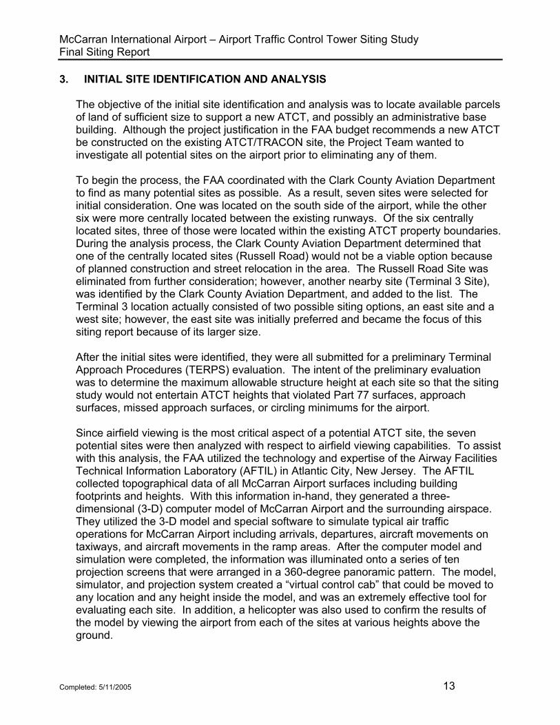
3. INITIAL SITE IDENTIFICATION AND ANALYSIS The objective of the initial site identification and analysis was to locate available parcels of land of sufficient size to support a new ATCT, and possibly an administrative base building. Although the project justification in the FAA budget recommends a new ATCT be constructed on the existing ATCT/TRACON site, the Project Team wanted to investigate all potential sites on the airport prior to eliminating any of them. To begin the process, the FAA coordinated with the Clark County Aviation Department to find as many potential sites as possible. As a result, seven sites were selected for initial consideration. One was located on the south side of the airport, while the other six were more centrally located between the existing runways. Of the six centrally located sites, three of those were located within the existing ATCT property boundaries. During the analysis process, the Clark County Aviation Department determined that one of the centrally located sites (Russell Road) would not be a viable option because of planned construction and street relocation in the area. The Russell Road Site was eliminated from further consideration; however, another nearby site (Terminal 3 Site), was identified by the Clark County Aviation Department, and added to the list. The Terminal 3 location actually consisted of two possible siting options, an east site and a west site; however, the east site was initially preferred and became the focus of this siting report because of its larger size. After the initial sites were identified, they were all submitted for a preliminary Terminal Approach Procedures (TERPS) evaluation. The intent of the preliminary evaluation was to determine the maximum allowable structure height at each site so that the siting study would not entertain ATCT heights that violated Part 77 surfaces, approach surfaces, missed approach surfaces, or circling minimums for the airport. Since airfield viewing is the most critical aspect of a potential ATCT site, the seven potential sites were then analyzed with respect to airfield viewing capabilities. To assist with this analysis, the FAA utilized the technology and expertise of the Airway Facilities Technical Information Laboratory (AFTIL) in Atlantic City, New Jersey. The AFTIL collected topographical data of all McCarran Airport surfaces including building footprints and heights. With this information in-hand, they generated a three-dimensional (3-D) computer model of McCarran Airport and the surrounding airspace. They utilized the 3-D model and special software to simulate typical air traffic operations for McCarran Airport including arrivals, departures, aircraft movements on taxiways, and aircraft movements in the ramp areas. After the computer model and simulation were completed, the information was illuminated onto a series of ten projection screens that were arranged in a 360-degree panoramic pattern. The model, simulator, and projection system created a “virtual control cab” that could be moved to any location and any height inside the model, and was an extremely effective tool for evaluating each site. In addition, a helicopter was also used to confirm the results of the model by viewing the airport from each of the sites at various heights above the ground.
Completed: 5/11/2005 13

McCarran International Airport – Airport Traffic Control Tower Siting Study Final Siting Report
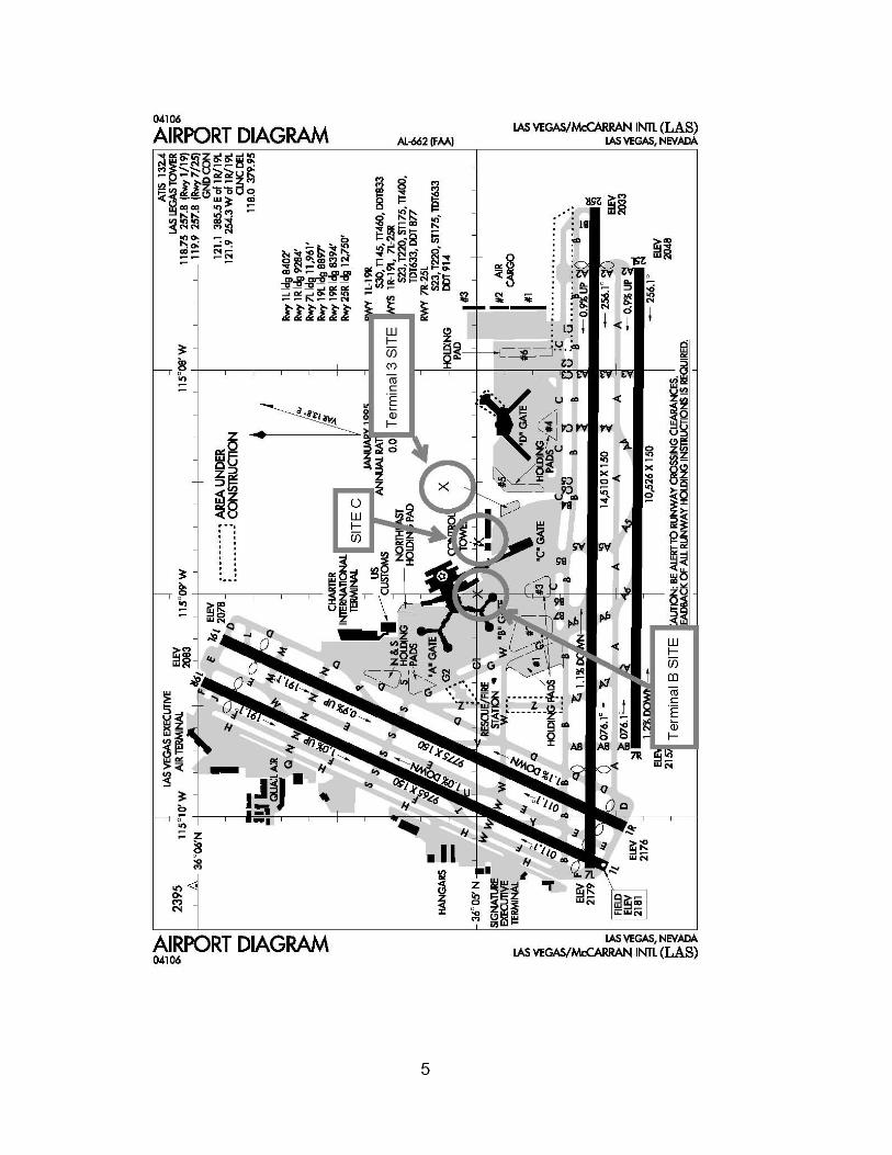
3.1 Initial Site Identification The initial siting study identified seven potential sites on and around the airport for initial analysis. They are generally described as follows, and are shown in Figure 2. Existing ATCT Property: The existing ATCT and Base Building are situated on a parcel of property that is approximately 345 feet by 290 feet. The property is leased from the Clark County Aviation Department and includes a chain link fence around the entire complex. The fence has an automatic security gate at the northeast corner of the lot that utilizes a card reader and intercom system to control access. There are approximately 116 parking spaces within the fenced boundary, and an elevated electric tram bisects the site. The tram is approximately 20 feet above the parking lot and shuttles passengers between Terminal 1 and the D Concourse.
Site A – This site is located in the northwest corner of the existing parking lot and is depicted in Figure 3. While this site is centrally located with respect to the east-west and north-south runways, and would potentially offer optimum viewing capability to all runways and taxiways, the construction activity would be complicated by the close proximity of the elevated tram and restricted site access. Construction deliveries and staging would be a major concern due to the limited access and available space. Semi-tractor trailer maneuverability, especially turn-around space, would have to be accommodated which could include site modifications and/or street relocations. Almost 70% of the on-site FAA employee parking spaces could be lost to accommodate the construction activity and the building footprint. Site B – This site is located in the center of the existing parking lot near the Base Building loading dock access drive, and is depicted in Figure 3. This site, similar to Site A, would potentially offer optimum viewing capability to all runways and taxiways. The construction activity would be complicated by the very close proximity of the elevated tram and restricted site access. Construction deliveries and staging would be a major concern due to the limited access and available space. Semi-tractor trailer maneuverability, especially turn-around space, would have to be accommodated which could include site modifications and/or street relocations. Almost 70% of the on-site FAA employee parking spaces could be lost to accommodate the construction activity and the building footprint. Site C – This site is located in the northeast corner of the existing parking lot near the chain link fencing entrance gate and is depicted in Figure 3. This site, similar to Sites A and B, would potentially offer optimum viewing capability to all runways and taxiways. The construction activity would be complicated by the close proximity of the elevated tram, restricted site access, and the nearby baggage tunnel just to the west of the ATCT site. Construction deliveries and staging would be a major concern due to the limited access and available space. Semi-tractor trailer maneuverability, especially turn-around space, would have to be accommodated which could include site modifications and/or street relocations.
Completed: 5/11/2005 14
Figure 2 – Initial Site Locations


Figure 3 – Existing ATCT Site Showing Locations of Sites A, B, and C


McCarran International Airport – Airport Traffic Control Tower Siting Study Final Siting Report
Almost 70% of the on-site FAA employee parking spaces could be lost to accommodate the construction activity and the building footprint. Also, the entrance gate through the chain link perimeter fence would have to be re-located.
Sunset Road: This site is located on the south side of Sunset Road, which runs along the southern boundary of the airport. The proposed site is a vacant lot approximately 1,200 feet west-southwest of the existing Remote Transmitter Receiver (RTR) facility, and is located in a light industrial/commercial business park. This site would minimize the viewing distances to the east-west runways as well as the southern approach end of the north-south runways. The viewing distance to the northern end of the north-south runways, however, would be maximized. Line-of-sight to all taxiways and most ramp areas would potentially be optimized from this site. It is of sufficient size to support the ATCT shaft as well as a small administrative Base Building, and employee parking. Construction activities on this site would have very little impact on the existing ATCT and TRACON, as well as the airport itself. Terminal B: This site is located on the Air Operations Area (AOA) in the ramp just west and north of Gate B-9 of Terminal 1. The Transportation Security Administration (TSA) is planning to construct a baggage screening facility in this area, and Gates B-3, B-4 and B8 have already been closed to accommodate the structure. This site is centrally located with respect to the east-west and north-south runways, and would minimize viewing distances to all runway ends. Line-of-sight to all taxiways would potentially be optimized from this location, but the line-of-sight to ramp areas would potentially be hindered near the base of the ATCT shaft. The site is of sufficient size to accommodate the ATCT shaft and a small administrative Base Building; however, due to its location on the AOA, employee parking would not be allowed near the facility. Construction activities on this site would have very little impact on the existing ATCT and TRACON. Russell Road: This site is located near the intersection of Paradise Road (the main ingress/egress road for McCarran Airport) and the new Russell Road location (Russell Road will be relocated to accommodate Terminal 3 construction). This site is centrally located with respect to the east-west and north-south runways, and would minimize viewing distances to all runway ends. Line-of-sight to all taxiways would potentially be optimized from this location. The site is of sufficient size to accommodate the ATCT shaft as well as a small administrative Base Building and employee parking. Construction activities on this site would have very little impact on the existing ATCT and TRACON, as well as the airport itself. Terminal 3: This site is located near the intersection of Kelly Lane and the current Russell Road location (on the east side of Kelly Lane). After Russell Road is re-located to the north, the area will be leveled for the future construction of Terminal 3. This site is centrally located with respect to the east-west and north-south runways, and would minimize viewing distances to all runway ends. Line-of-sight to all taxiways would potentially be optimized from this location. The site is of sufficient size to accommodate the ATCT shaft as well as a small administrative Base Building and
Completed: 5/11/2005 15
McCarran International Airport – Airport Traffic Control Tower Siting Study Final Siting Report
employee parking. Construction activities on this site would have very little impact on the existing ATCT and TRACON, as well as the airport itself. Incidentally, there is a site available on the west side of Kelly Lane in the same location that would have the same basic advantages/disadvantages as the site on the east side of Kelly Lane described above. As mentioned earlier, the east site was initially preferred due to the larger plot of available land, which would be desirable for security setback distances and future expansion capabilities.
3.2 Analysis of Initial Sites
3.2.1 Minimum Viewing Heights for 35-Minute Angle
As discussed in the siting criteria summary, the FAA has established that an ATCT should be tall enough to ensure that the lines-of-sight to all airport surfaces have vertical angles of at least 35 minutes. This angle is the minimum needed to provide adequate perspective and depth perception for controllers. Accordingly, the viewing height that would be required to obtain the minimum 35-minute site line angle was calculated for each site. The calculations considered each end of each of the four runways at McCarran Airport. The viewing heights necessary to provide the minimum 35-minute vertical sight line angle to all airport surfaces were considered the “minimum” viewing height; however, this “minimum” is not related to the viewing height required to provide a clear view of all aircraft movement areas (e.g. the viewing height needed to avoid movement area shadowing). Table 1 depicts the minimum viewing heights calculated for each sight line to each runway end for each proposed tower site.
Completed: 5/11/2005 16

McCarran International Airport – Airport Traffic Control Tower Siting Study Final Siting Report
01R 19L 01L 19R 07L 25R 07R 25LTHRESHOLD ELEV (MSL) 2174 2076 2178 2081 2177 2031 2155 2046RUNWAY LENGTH (FT)
RUNWAY SLOPE (FT/FT) -0.0100 0.0100 -0.0099 0.0099 -0.0101 0.0101 -0.0103 0.0103ANGULAR SLOPE (min.) -34.38 34.38 -34.03 34.03 -34.72 34.72 -35.41 35.41
ADistance to Threshold (FT) 6,745 5,910 7,340 6,580 7,150 8,160 5,365 7,280
Base El. Minimum Viewing Elevation Required (MSL) 2175 2195 2180 2213 2178 2197 2154 2195
2089 Approx. Minimum Viewing Height (AGL) 86 106 91 124 89 108 65 106
BDistance to Threshold (FT) 6,810 5,950 7,410 6,640 7,206 8,085 5,420 7,215
Base El. Minimum Viewing Elevation Required (MSL) 2175 2196 2180 2214 2178 2195 2154 2194
2089 Approx. Minimum Viewing Height (AGL) 86 107 91 125 89 106 65 105
CDistance to Threshold (FT) 7,000 5,905 7,590 6,605 7,405 7,965 5,630 7,100
Base El. Minimum Viewing Elevation Required (MSL) 2175 2195 2180 2214 2178 2193 2154 2191
2089 Approx. Minimum Viewing Height (AGL) 86 106 91 125 89 104 65 102
Distance to Threshold (FT) 3,450 10,460 4,215 10,750 4,340 11,705 2,460 10,200
Minimum Viewing Elevation Required (MSL) 2175 2287 2179 2297 2177 2268 2155 2255
Approx. Minimum Viewing Height (AGL) 15 127 19 137 17 108 -5 95
Distance to Threshold (FT) 5,935 5,580 6,460 6,140 6,250 9,170 4,730 8,215
Minimum Viewing Elevation Required (MSL) 2175 2189 2180 2204 2178 2217 2154 2214
Approx. Minimum Viewing Height (AGL) 75 89 80 104 78 117 54 114
Distance to Threshold (FT) 8,510 4,400 8,975 5,265 8,730 8,340 7,360 7,865
Minimum Viewing Elevation Required (MSL) 2176 2165 2181 2187 2178 2200 2154 2207
Approx. Minimum Viewing Height (AGL) 116 105 121 127 118 140 94 147
Distance to Threshold (FT) 9,065 6,230 9,640 7,040 9,440 7,210 7,720 6,700
Minimum Viewing Elevation Required (MSL) 2176 2202 2181 2222 2178 2177 2154 2183
Approx. Minimum Viewing Height (AGL) 116 142 121 162 118 117 94 123
RUNWAY 07R-25L
9,770 9,770 14,505 10,525
RUNWAY 01R-19L RUNWAY 01L-19R RUNWAY 07L-25R
Base El.
2060
RUNWAY DATA
TERMINAL 3
2100
2060
EX
ISTI
NG
ATC
T P
RO
PE
RTY
POTENTIAL ATCT SITE w/GROUND
ELEVATION (MSL)
SUNSET ROAD
Base El.
2160
TERMINAL B
Base El.
Base El.
RUSSELL ROAD
Table 1 – Minimum Viewing Elevations and Heights for Minimum 35-Minute Angle
3.2.2 Maximum Allowable ATCT Heights
Completed: 5/11/2005 17
McCarran International Airport – Airport Traffic Control Tower Siting Study Final Siting Report
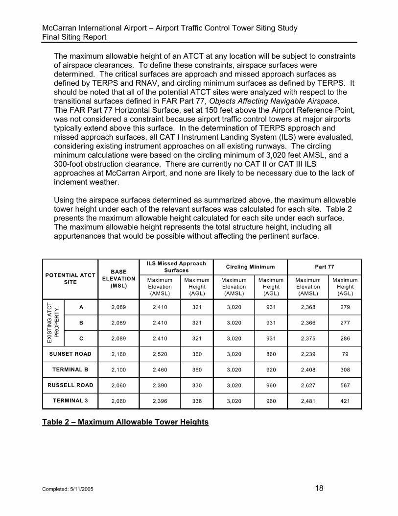
The maximum allowable height of an ATCT at any location will be subject to constraints of airspace clearances. To define these constraints, airspace surfaces were determined. The critical surfaces are approach and missed approach surfaces as defined by TERPS and RNAV, and circling minimum surfaces as defined by TERPS. It should be noted that all of the potential ATCT sites were analyzed with respect to the transitional surfaces defined in FAR Part 77, Objects Affecting Navigable Airspace. The FAR Part 77 Horizontal Surface, set at 150 feet above the Airport Reference Point, was not considered a constraint because airport traffic control towers at major airports typically extend above this surface. In the determination of TERPS approach and missed approach surfaces, all CAT I Instrument Landing System (ILS) were evaluated, considering existing instrument approaches on all existing runways. The circling minimum calculations were based on the circling minimum of 3,020 feet AMSL, and a 300-foot obstruction clearance. There are currently no CAT II or CAT III ILS approaches at McCarran Airport, and none are likely to be necessary due to the lack of inclement weather. Using the airspace surfaces determined as summarized above, the maximum allowable tower height under each of the relevant surfaces was calculated for each site. Table 2 presents the maximum allowable height calculated for each site under each surface. The maximum allowable height represents the total structure height, including all appurtenances that would be possible without affecting the pertinent surface.
A 2,089 2,410 321 3,020 931 2,368 279
B 2,089 2,410 321 3,020 931 2,366 277
C 2,089 2,410 321 3,020 931 2,375 286
2,160 2,520 360 3,020 860 2,239 79
2,100 2,460 360 3,020 920 2,408 308
2,060 2,390 330 3,020 960 2,627 567
2,060 2,396 336 3,020 960 2,481 421
Maximum Height (AGL)
Maximum Elevation (AMSL)
Maximum Height (AGL)
Part 77
Maximum Elevation (AMSL)
Maximum Height (AGL)
TERMINAL 3
Circling Minimum
EX
ISTI
NG
ATC
T P
RO
PE
RTY
SUNSET ROAD
TERMINAL B
RUSSELL ROAD
ILS Missed Approach Surfaces
POTENTIAL ATCT SITE
BASE ELEVATION
(MSL)Maximum Elevation (AMSL)
Table 2 – Maximum Allowable Tower Heights
Completed: 5/11/2005 18

McCarran International Airport – Airport Traffic Control Tower Siting Study Final Siting Report
3.3 Summary Comparison of Initial Sites A summary comparison of all seven initial sites is provided in the matrix of Table 3. The comparison matrix summarizes a variety of factors and considerations pertinent to the ATCT siting analysis, including cab height and shadowing conditions, distance to runway thresholds, site access, and primary viewing orientation.
3.4 Identification of Primary Siting Options Based on a review of the initial analysis of sites, discussions with FAA and Clark County Department of Aviation personnel, and results from the model/simulation at the AFTIL in Atlantic City, New Jersey, three sites were identified for further analyses and evaluation. The three sites include Site C (existing ATCT property – near the security gate), the Terminal 3 Site (east side of Kelly Lane), and the Terminal B Site. The selection of these three sites stemmed largely from the better airfield viewing conditions that would be offered from these locations as well as the minimized shadowing impact by the new ATCT structure during construction while still viewing from the existing ATCT cab. As cited previously, the Terminal 3 Site actually consists of two potential sites – one on the east side of Kelly Lane and one on the west side of Kelly Lane. The two sites are located less than 200 feet apart. This siting report focuses on the east site (2.5 acres) because it is considerably larger than the proposed west site (1.5 acres). With the exception of the size, each of the two Terminal 3 sites would offer the same operational advantages/disadvantages; therefore, the sites could be considered virtually interchangeable.
3.5 Elimination of Unfavorable Sites The four sites that were eliminated from further consideration were removed for different reasons. The Russell Road site was removed at the request of the Clark County Aviation Department. Due to the relocation of Russell Road and future construction in the area, they determined that no viable parcel of land would be available for development by FAA for an ATCT. Sites A and B on the existing ATCT property were eliminated after viewing the AFTIL model/simulation. The model/simulation clearly showed that a new ATCT constructed in either location would severely shadow the final approach and touchdown areas of Runways 19R and 19L while viewing from the existing ATCT cab. Although the shadowing would have only been an issue once the new construction progressed above the existing cab level until commissioning of the new ATCT, the impact to the air traffic controllers was deemed to be too severe even for an interim period. Lastly, the Sunset Road Site, which was the only off-airport site, was eliminated due to a marked increase in real estate prices over the past few months. Because of the higher prices, the Clark County Aviation Department could not justify a land deal with the property owner, and the FAA could not pursue purchasing the property outright.
Completed: 5/11/2005 19

McCarran International Airport – Airport Traffic Control Tower Siting Study Final Siting Report
3.6 Airfield Viewing/Shadow Analysis of Primary Siting Options Shadow analyses, consisting of analyses of the airfield areas that would be unobservable from a control tower at a given site for a given viewing height, are a critical element of the evaluation of potential tower sites. Based on the accuracy and effectiveness of the AFTIL model/simulation, it was determined that shadow analyses would only be performed on the primary siting options. The results of the shadow studies are included in Appendix 2. Shadow diagrams are included for the following conditions:
Existing ATCT - eye height at 185 feet AGL (2,274 feet AMSL) Site C - eye height at 200 feet AGL (2,289 feet AMSL) Site C - eye height at 265 feet AGL (2,354 feet AMSL) Terminal B Site - eye height at 200 feet AGL (2,300 feet AMSL) Terminal B Site - eye height at 254 feet AGL (2,354 feet AMSL) Terminal 3 Site - eye height at 250 feet AGL (2,310 feet AMSL) Terminal 3 Site - eye height at 294 feet AGL (2,354 feet AMSL)
The shadow analyses must be based on feasible tower heights. The three factors related to the optimum tower height – the minimum height needed for the minimum 35-minute vertical sight line angle, the maximum allowable height based on airspace constraints, and the height needed for ideal viewing conditions – were evaluated based on the calculations described in the foregoing. A comparison of the three factors for each site shows that the heights needed for the 35-minute viewing angle would be, as expected, substantially lower than the heights needed for ideal viewing conditions. The comparison also shows that the heights needed for ideal viewing conditions are below the maximum allowable heights. This was found to be the case at all three potential sites, although an ATCT constructed at the Terminal 3 Site for ideal viewing conditions appears to be very close to the maximum allowable tower height allowed by TERPS evaluations. For the purposes of creating a baseline to evaluate the airfield shadowing conditions from the three primary sites, shadows were first generated for the existing ATCT, which has a viewing elevation of 185 feet AGL (2,274 feet AMSL). The problem areas are evident from this location, especially when viewing Taxiways D and N behind the Terminal 2 building. From Site C at an elevation of 200 feet AGL (2,289 feet AMSL), the existing ATCT creates a shadow across the threshold of Runway 7R and does not improve the line-of-sight viewing to Taxiway D or N behind Terminal 2. From an elevation of 265 feet AGL (2,354 feet AMSL) at Site C, the viewing to the trouble areas, as well as the entire airport, is dramatically improved. At this elevation, viewing over top of the existing ATCT and Terminal 2 is achieved. From the Terminal B Site at an elevation of 200 feet AGL (2,300 feet AMSL), the existing ATCT creates a shadow across the threshold of Runway 25R; however, all other airport surfaces are visible.
Completed: 5/11/2005 20

McCarran International Airport – Airport Traffic Control Tower Siting Study Final Siting Report
From an elevation of 254 feet AGL (2,354 feet AMSL) at the Terminal B Site, the threshold of Runway 25R is visible because viewing is over top of the existing ATCT. From the Terminal 3 Site at an elevation of 250 feet AGL (2,310 feet AMSL), the existing ATCT creates a shadow across the touchdown area of Runway 7L, and does not allow complete line-of-sight viewing to Taxiways D and N behind Terminal 2. From an elevation of 294 feet AGL (2,354 feet AMSL) at the Terminal 3 Site, the line-of-sight problems have been eliminated by allowing viewing over top of the existing ATCT and Terminal 2.
Completed: 5/11/2005 21

McCarran International Airport – Airport Traffic Control Tower Siting Study Final Siting Report
LocationMinimum Height 35 min. viewing angle (Note 1)
Maximum Allowable Height (Note 2)
Shadowing Conditions
Greatest Distance to
Runway Threshold
Site Accommodations
A
Centrally located on airport. Northwest corner of existing ATCT/TRACON
parking lot.
2213 AMSL (124 feet AGL) Runway 19R
2410 AMSL (291 feet viewing
height)
Significant shadowing at 200 feet AGL. Very minimal or no
shadowing at 265 feet AGL.
8,160 feet to Runway 25R
New ATCT with link to existing Base
Bldg/TRACON. On-site parking for employees
after construction is complete.
B
Centrally located on airport. Middle of
existing ATCT/TRACON parking lot near loading dock.
2214 AMSL (125 feet AGL) Runway 19R
2410 AMSL (291 feet viewing
height)
Significant shadowing at 200 feet AGL. Very minimal to no
shadowing at 265 feet AGL.
8,085 feet to Runway 25R
New ATCT with link to existing Base
Bldg/TRACON. On-site parking for employees.
C
Centrally located on airport. Northeast corner of existing ATCT/TRACON
parking lot.
2214 AMSL (125 feet AGL) Runway 19R
2410 AMSL (291 feet viewing
height)
Significant shadowing at 200 feet AGL. Very minimal to no
shadowing at 265 feet AGL.
7,965 feet to Runway 25R
New ATCT with link to existing Base
Bldg/TRACON. On-site parking for employees.
South side of airport. Approximately 2,500 feet south-southeast
of threshold of Runway 7R
2297 AMSL (137 feet AGL) Runway 19R
2520 AMSL (330 feet viewing
height)
Shadowing not a concern. Depth
percemption to 19R and 19L a problem at lower viewing heights
11,705 feet to Runway 25R
New ATCT with new administrative Base
Building. On-site parking for employees.
Centrally located on airport. Near B Gates of Main Terminal. On
the AOA.
2217 AMSL (117 feet AGL) Runway 25R
2460 AMSL (330 feet viewing
height)
Significant shadowing at 200 feet AGL. Very minimal to no
shadowing at 254 feet AGL.
9,170 feet to Runway 25R
New ATCT with new administrative Base Building. No on-site
parking for employees.
Centrally located on airport. Near intersection of
Paradise Road and relocated Russell
Road.
2207 AMSL (147 feet AGL) Runway 25L
2390 AMSL (300 feet viewing
height)
Significant shadowing at 250 feet AGL. Very minimal to no
shadowing at 294 feet AGL.
8,975 feet to Runway 01L
New ATCT with new administrative Base
Building. On-site parking for employees.
Centrally located on airport. Near
intersection of Kelly Lane and existing
Russell Road. Near Future Terminal 3.
2222 AMSL (162 feet AGL) Runway 19R
2396 AMSL (306 feet viewing
height)
Significant shadowing at 250 feet AGL. Very minimal to no
shadowing at 294 feet AGL.
9,640 feet to Runway 01L
New ATCT with new administrative Base
Building. On-site parking for employees.
RUSSELL ROAD
TERMINAL 3
EXIS
TIN
G A
TCT
PRO
PER
TY
Potential ATCT Sites
SUNSET ROAD
TERMINAL B
Table 3 – Summary Comparison of Preliminary Siting Options
Completed: 5/11/2005 22

McCarran International Airport – Airport Traffic Control Tower Siting Study Final Siting Report
Personnel Access Viewing Orientation Comments
A
Potential off-site parking during construction and
on-site parking after construction.
All directions; however, very minimal to the
northeast
Good viewing from 265 feet AGL. Difficult construction site. Impacts viewing from
existing cab.
B
Potential off-site parking during construction and
on-site parking after construction.
All directions; however, very minimal to the
northeast
Good viewing from 265 feet AGL. Difficult construction site. Impacts viewing from
existing cab.
C
Potential off-site parking during construction and
on-site parking after construction.
All directions; however, very minimal to the
northeast
Good viewing from 265 feet AGL. Difficult construction
site.
On-site parking and direct access to ATCT
West, north, and east primary. Minimal to
south.
Largest site. Good ramp visibility. Maximizes distance
to Runway 19R/L
No on-site parking and access via Main
Terminal
All directions; however, very minimal to the
northeast
Very good visibility of airport surfaces at 254 feet AGL.
AOA location creates problems.
On-site parking and direct access to ATCT
All directions; however, very minimal to the
northeast
Centrally located. Good visibiity of airport at 294 feet
AGL. Large site.
On-site parking and direct access to ATCT
All directions; however, very minimal to the
northeast
Centrally located. Good visibiity of airport at 294 feet
AGL. Large site.
RUSSELL ROAD
TERMINAL 3
Potential ATCT Sites
EXIS
TIN
G A
TCT
PRO
PER
TY
SUNSET ROAD
TERMINAL B
missed approach surfaces) withouth adjustments and includes the entire structure; "Viewing Height" means total structure height minus 30 feet
Note 1 - Minimum height shown is minimum viewing height, based on a 35-minute verical viewing angle.
Note 2 - Maximum allowable height is determined from airspace constraints (approach and
Table 3 – Summary Comparison of Preliminary Siting Options (Continued)
Completed: 5/11/2005 23

McCarran International Airport – Airport Traffic Control Tower Siting Study Final Siting Report
4. EVALUATION OF PRIMARY SITING OPTIONS The following sections provide evaluations of the three primary siting options that remained after the initial siting analysis. The three primary siting options are Site C, Terminal 3, and Terminal B. The evaluations include a brief description of each site, and an assessment of each site with regard to the siting requirements established in FAA Order 6480.4, Airport Traffic Control Tower Siting Criteria, and other considerations described in earlier sections of this report.
4.1 Site C
4.1.1 Site Description Site C is located in the northeast corner of the existing ATCT/TRACON property. A new ATCT would be constructed in the parking lot near the existing entrance gate of the security fence that surrounds the leased property, and would require the entrance gate to be relocated. An ATCT constructed at this location would potentially offer excellent line-of-sight to all runways and taxiways, as well as most ramp areas. Because it is centrally located, this site would also minimize the sight distances to the ends of all of the runways. Site C would allow the utilization of the existing Base Building/TRACON for administrative and operational needs, and some type of link would likely connect the two structures. The characteristics of Site C include the following:
The site is located approximately 2,500 feet north of the centerline of Runway 7L-25R and 4,225 feet east of the centerline of Runway 1R-19L.
•
• Distances from Site C to the runway thresholds are:
01R – 7,000 feet 19L – 5,905 feet 01L – 7,590 feet 19R – 6,605 feet 07L – 7,405 feet 25R – 7,965 feet 07R – 5,630 feet 25L – 7,100 feet
As part of the initial analysis, an Airspace Study (Standard FAA Form 7460-1, Notice of Proposed Construction or Alteration) was conducted for Site C. The following information was submitted:
Latitude: 36o 04’ 59.61” Longitude: 115o 08’ 47.68” Site Elevation: 2,089 feet AMSL Total Structure Height: 300 feet AGL Overall Height: 2,389 feet AMSL
Completed: 5/11/2005 24
McCarran International Airport – Airport Traffic Control Tower Siting Study Final Siting Report
The conclusions of the airspace study by the San Francisco Airports Division Office show that there are no objections to an ATCT structure of the submitted height at the proposed location. Construction of an ATCT at Site C would be very challenging and create the most impacts to the existing ATCT/TRACON as well as FAA employees. The proximity of the elevated tram that carried passengers from Terminal 1 to the D Concourse, as well as the baggage tunnel to the east, and Wright Brothers Lane to the north all combine to create a very confined work site. A construction expert from Jacobs Engineering investigated the existing site, along with its restrictive parameters, to determine the feasibility of constructing a new ATCT there. A copy of the constructability report is included in Appendix 3. The conclusions from the report are summarized as follows:
• There will be a premium of approximately 50% due to 1) positioning of the crane as well as lack of an adequate staging area for construction materials; 2) meeting security requirements; 3) protecting the elevated passenger tram and baggage tunnel; 4) accommodating construction traffic; and 5) sustaining FAA operations during construction.
• Of the 116 existing parking spaces, approximately 80 spaces would likely be eliminated during the construction phase of the project to provide the contractor with limited on-site parking, material staging, and construction trailer space. Parking for displaced FAA employees would likely be in the airport parking garage, which is located near Terminal 1. The walk from the garage to the front door of the Base Building would take approximately ten minutes.
Also, the report from Jacobs Engineering states that the seismic requirements for Las Vegas would require steel framed construction, which is more elastic during a seismic event. The blast requirements would tend to require very thick concrete walls, which produce a very rigid structure. This type of rigid structure is not compatible with the seismic design and the report states “It appears that the project cannot be designed to meet both sets of criteria with the limitations imposed by this site”.
4.1.2 Site C Tower Height Requirement The minimum tower viewing height needed to provide a 35-minute viewing angle to all airfield surfaces was calculated to be approximately 125 feet above ground level. The corresponding elevation would be 2,214 feet AMSL. The total ATCT height would be approximately 155 feet above ground level, assuming a 30-foot height of tower cab roof structure, antennas, air terminals, or other appurtenances above the viewing height (35 feet above the cab floor height). The top of the tallest tower appurtenances to accommodate the minimum tower viewing height would be at 2,244 feet AMSL. Since the Project Team did not want to waste time and effort entertaining tower heights that were unreasonably tall, a preliminary TERPS analysis was completed to establish the maximum allowable tower height at Site C. Based on that analysis, the maximum
Completed: 5/11/2005 25

McCarran International Airport – Airport Traffic Control Tower Siting Study Final Siting Report
allowable tower height (to the tallest appurtenances) was calculated to be 321 feet above ground level (2,410 feet AMSL). Based on the AFTIL model/simulation, the tower viewing height needed to provide full visibility to all runways and taxiways was determined to be 265 feet above ground level. The corresponding elevation would be 2,354 feet AMSL. The total ATCT height would be approximately 295 feet above ground level, assuming a 30-foot height of tower cab roof structure, antennas, air terminals, or other appurtenances above the viewing height (35 feet above the cab floor height). The top of the tallest tower appurtenances would be 2,384 feet AMSL, which is 56 feet below the maximum allowable tower elevation of 2,410 feet AMSL at this location.
4.1.3 Site C Siting Criteria Evaluation – Mandatory Requirements a. Maximum Visibility of Airborne Traffic Patterns: An ATCT constructed at Site C
would provide full visibility of all airborne traffic patterns, including aircraft approaches to, and departures from, all existing runways. Due to the existing airport layout and the surrounding development there are no plans to extend existing runways or add new runways at McCarran Airport.
b. Complete Visibility of Airport Movement Area: Complete visibility of all airport movement areas cannot be achieved at a viewing height of 200 feet AGL (2,289 feet AMSL). The existing ATCT would potentially block visibility to the threshold/touchdown area of Runway 7R and the line-of-sight to Taxiway Delta would be impaired by Terminal 2, especially for smaller aircraft. Complete visibility of all airport movement areas can be achieved at a viewing height of 265 feet AGL (2,354 feet AMSL). The areas that were a concern at 200 AGL are not a concern at this elevation, which allows viewing over the top of the existing ATCT and Terminal 2. Visibility to all gates and ramps is not possible at this elevation; however, these areas are controlled by Clark County Aviation Department and there are no plans to turn this function over to FAA.
c. Sufficient Site Area to Accommodate Existing and Future Facilities: As stated earlier, constructing a new ATCT on Site C will be challenging. The elevated tram that shuttles passengers from Terminal 1 to Concourse D bisects the existing ATCT site and will restrict/impact the construction activities for the new ATCT. Precautions will be necessary to ensure the tram is not damaged or impacted by construction activities. Wright Brothers Lane to the north of the site and an underground baggage tunnel to the east will further complicate the construction activities. Also, FAA employee parking will be impacted for two to three years during the construction and installation phases of the project. Off-site parking for about 86 vehicles would have to be identified and secured before starting construction. After commissioning of the new ATCT, further impacts to FAA parking will last up to two years until the old ATCT structure is demolished.
Completed: 5/11/2005 26
McCarran International Airport – Airport Traffic Control Tower Siting Study Final Siting Report
d. Compliance with FAR Part 77: A tower constructed at Site C would not interfere with Part 77 runway approach, primary, or transitional surfaces; however; a tower of a functional height would extend above the Part 77 horizontal surface which would be 2,331 feet AMSL (150 feet above the Airport Reference Point). To stay below this point a tower at Site C would not offer acceptable airfield viewing capabilities.
e. Derogation of Existing or Planned Electronic Facilities: A cursory review of existing FAA facilities on and around the airport does not raise any concerns with respect to constructing a new ATCT at Site C. The systems that were considered included the RTR, VORTAC, ASDE, ASR and RCL. Further examination is required to determine if a new ATCT constructed at Site C would interfere/block the existing RCL path, and if the RCL path could be re-established with antennas mounted on the new ATCT. Once a final site is selected, an in-depth analysis will have to be conducted by FAA to ensure that no electronic facilities/equipment would be adversely impacted by the new ATCT.
4.1.4 Site C Siting Criteria Evaluation – Non-mandatory Requirements
a. Depth Perception to Controlled Surfaces: A tower constructed at Site C with a
viewing height of 265 feet AGL (elevation 2,354 feet AMSL) would provide a minimum vertical angle of 35-minute to all controlled surfaces.
b. Orientation of Tower Cab: Site C is centrally located between the east-west and north-south runways so airfield viewing will range from the north-northeast counterclockwise around to the east-southeast. Airborne traffic patterns will require 360-degree viewing from the tower cab; however, viewing will be minimal to the northeast while all other directions will be prominent.
c. Visibility Impairment by External Light Sources: The hotel/casino lights on the Las Vegas Strip could impact Viewing to the west and northwest. Because of the magnitude of lighting associated with the hotels and casinos, this impact will be common at virtually every site. During certain times of the year, reflections from the sun off of the Mandalay Bay hotel/casino will be a concern, especially during the early morning hours when the sun is low in the eastern sky. This impact will likely be common at virtually every site sometime throughout each year.
d. Visibility of All Ground Operation Areas: Visibility of all ground movement areas would be provided from an ATCT at Site C with the exception of some ramp areas from an elevation of 265 feet AGL (2,354 feet AMSL). As mentioned earlier, viewing of the ramp areas is not an issue because these areas are controlled by Clark County Aviation Department and there are no plans to turn this function over to FAA.
e. Visibility Restrictions Due to Local Weather Phenomena: No weather phenomena
Completed: 5/11/2005 27

McCarran International Airport – Airport Traffic Control Tower Siting Study Final Siting Report
exist that would particularly affect viewing conditions from a tower at Site C in comparison to the other potential sites. Research of historical weather data show that fog and/or low ceiling conditions, which could impact taller towers, are basically non-existent at McCarran Airport because of its desert location.
f. Exterior Noise Conditions: Due to its proximity to the existing ATCT, a tower at Site C would experience very similar aircraft noise. Site C is located approximately 1,500 feet from the B Gates and less than 1,000 feet from the C Gates. Due to the distance from ramp/taxiway areas to the ATCT, the noise impact to the ATCT should be minimal. The noise generated by construction vehicles could impact the existing operations in the TRACON and ATCT cab. Some vibration could be expected in the existing facilities as well.
g. Site Access: Access to Site C would be via public streets into and on the airport, and very similar to how the existing ATCT/Base Building site is accessed. The current on-site parking would be impacted by construction activities, and additional off-site parking for FAA employees would be required. Access for construction vehicles, especially semi-tractor trailers, can be accommodated; however, the Clark County Aviation Department would have to approve any proposed changes to existing roads and/or traffic patterns. Semi-tractor trailer access will be difficult; however, it could be established with some site modifications, revisions to existing traffic patterns, or combination of both.
h. Consideration of Planned Airport Expansion: Long-term future development of the airport, including Concourse D, Terminal 3, and the TSA security building has been considered in this siting study.
i. Smoke, Dust and Exhaust Fume Conditions: The likelihood of aircraft or ground vehicle exhaust fumes contaminating the new ATCT ventilation system, or air quality in the facility is very low. Site C is not on the AOA of the airport, therefore, no special precautions should be required for the HVAC system(s). Separate from aircraft and vehicle exhaust fumes, industrial smoke, dust and other fumes are not expected to be significant issues at McCarran Airport. There is a possibility that construction activities for the new ATCT may affect the existing ATCT and TRACON, while the demolition activities for the old ATCT may affect the TRACON and new ATCT.
4.1.5 Site C Siting Criteria Evaluation – Other Considerations a. Airspace Clearances: An ATCT constructed at Site C could have an overall
maximum structure height of 321 feet (2,410 feet AMSL) without impacting missed approach surfaces or circling minimums.
Completed: 5/11/2005 28

McCarran International Airport – Airport Traffic Control Tower Siting Study Final Siting Report
b. Accessibility of Utility Services: Access to all necessary utilities is readily available
at Site C. The existing ATCT/Base Building is approximately 100 feet from Site C and utilities could be extended to the new ATCT in an efficient and economical manner. These utilities include water, sanitary sewer, storm drainage, electricity, natural gas, and telephone.
c. Fiber Optic Cable Loop: There is currently a FAA fiber optic cable loop project underway at McCarran Airport that will interconnect all of the FAA facilities on the airport. The cable loop project is currently in the final engineering stages and actual construction is scheduled for completion in March of 2005. The cable loop can easily be extended to the new ATCT location, because it is already designed to encompass the existing ATCT/TRACON facility.
d. Site Security: The new ATCT would be protected by a perimeter fence (chain link), and a controlled access entrance gate; however, Site C is less than 50 feet from the public street (Wright Brothers Lane) that runs in front of the existing ATCT/Base Building. The recommended exterior setback (distance to perimeter of FAA site) of 300 feet cannot be met, and the interior setback distance (closest edge of FAA parking lot) of 100 feet will likely not be attained either. The ATCT structure will likely require “hardening measures” due to the increased blast pressures resulting from the reduced setback distances. The extent of those measures will have to be determined by a qualified blast consultant. During the construction phase of the project, additional guard force staffing in excess of the current FAA Order 1600.6B requirement would likely be necessary to mitigate the risk of construction vehicles and personnel operating so close to the existing ATCT and TRACON. Exterior security features such as cameras and card readers may have to be relocated or repositioned to ensure adequate protection for the operational facility. Another risk-mitigating feature that should also be considered is reducing access on Wright Brothers Lane. This could be accomplished by installing a new barrier and card reader as far away as possible (to the east) on Wright Brothers Lane, and rerouting the Southwest Airlines cargo facility (just west of existing ATCT site) traffic off of Wright Brothers Lane and onto the main airport road for departing flights.
e. Site Development Costs: The expected site development costs for Site C would likely be higher due to the confined nature of the site. The existing parking canopies would have to be removed before construction and re-installed at the conclusion of construction. The elevated tram would require structural protection due to the overhead construction activities in close proximity to the tram. An area in the median north of Wright Brothers Lane would have to be structurally prepared (cleared, leveled, compacted, etc) for setting up a tower crane. Also, Wright Brothers Lane will likely require some minor modifications to allow semi-tractor trailer ingress/egress, and traffic flow. Lastly, careful structural consideration and
Completed: 5/11/2005 29

McCarran International Airport – Airport Traffic Control Tower Siting Study Final Siting Report
design would be required to ensure the ATCT foundation would not put undue pressure/stress on the baggage tunnel to the east of the site. Extension of utilities at Site C would likely be cheaper than any of the other potential sites due to the close proximity of the existing lines.
f. Environmental Data: A preliminary Phase I Environmental Due Diligence Audit (EDDA) showed that the existing ATCT and Base Building/TRACON were constructed in the early 1980’s. Since the FAA has been in control of the property for over 20 years, and we do not typically engage in activities that require the handling of hazardous materials, the potential for contamination of the air, soil, or ground water around Site C is low. Construction of the new ATCT is not expected to produce any contamination. Based on the preliminary Phase One EDDA, a Phase Two EDDA would not be required for Site C.
g. Risk Management: Constructing an ATCT at Site C will pose a higher risk to the existing ATCT and TRACON facilities, as well as the airport roads and elevated tram that carries passengers to and from Concourse D. Although the risk is perceived to be low, a construction accident (such as a lost load from the crane, or collapse of the crane) has the potential to interrupt service to the control tower, TRACON, airport ingress/egress roads, and/or the passenger tram. The severity of the interruption would be solely dependent upon the severity of the accident. In this situation, the financial impacts to FAA or airport operations would be difficult to calculate; however, due to the number of air carriers at McCarran and the number of passengers traveling to and from Las Vegas each day, the costs could be very high. There is also an increased risk of interrupting the tower and TRACON operations by disturbing/disconnecting an existing utility line that feeds those facilities. Due to the number of service lines on the site this risk is perceived to be medium in nature and the direct impact to the FAA facilities would be dependent upon the type of utility that was affected and the degree of damage imposed.
h. Airport Tenant Manual: As mentioned previously, Site C is located on airport property; therefore, the Airport Tenant Manual that is published, maintained, and enforced by the Clark County Aviation Department would apply to an ATCT constructed at this site. Complying with the manual could potentially have a fiscal and/or schedule impact to the project.
i. Seismic vs. Blast Design Requirements: The seismic requirements and soil conditions for Las Vegas would likely warrant steel-framed construction for elasticity and flexibility of the ATCT structure; however, the blast requirements would likely stipulate thick, heavy concrete walls that can resist blast over-pressures. This would create a very rigid structure, which would be in direct conflict with the seismic requirements. Unless the security requirements are relaxed, it does not appear that both sets of criteria (seismic and security) can be met at Site C.
Completed: 5/11/2005 30
McCarran International Airport – Airport Traffic Control Tower Siting Study Final Siting Report
4.2 Terminal 3 Site
4.2.1 Site Description The primary Terminal 3 Site is located in the southeast quadrant of the intersection of Kelly Lane and Russell Road. It is triangular shaped and approximately 2.5 acres in size. A new ATCT constructed at this Terminal 3 Site would be centrally located between the runways, and would potentially offer excellent line-of-sight to all runways and taxiways, as well as most ramp areas. Because it is centrally located on the airport, this site would generally minimize the sight distances to the ends of all of the runways, but more so to Runways 25R and 25L. A second potential Terminal 3 Site is located just 200 feet to the southwest of the primary Terminal 3 Site on the west side of Kelly Lane. The property originally offered by the Clark County Aviation Department as a possible second site at Terminal 3 was considerably smaller than the primary (east) site; therefore, the eastern site was considered more desirable and was the focus of this Siting Report. All of the information and findings contained in this report concerning the Terminal 3 Site pertain directly to the primary siting option (east side of Kelly Lane). Since the two potential sites are in such close proximity to each other, the information and findings contained in this report for the east site would be virtually identical and directly applicable to the site on the west side of Kelly Lane. The characteristics of the primary Terminal 3 Site include the following:
The site is located approximately 4,000 feet north of the centerline of Runway 7L-25R and about 5,700 feet east of the centerline of Runway 1R-19L.
•
• Distances from the Terminal 3 Site to the runway thresholds are:
01R – 9,065 feet 19L – 6,230 feet 01L – 9,640 feet 19R – 7,040 feet 07L – 9,440 feet 25R – 7,210 feet 07R – 7,720 feet 25L – 6,700 feet
As part of the initial analysis, an Airspace Study (Standard FAA Form 7460-1, Notice of Proposed Construction or Alteration) was conducted for the Terminal 3 Site. The following information was submitted:
Latitude: 36o 05’ 08.47” Longitude: 115o 08’ 26.19” Site Elevation: 2,060 feet AMSL Total Structure Height: 325 feet AGL Overall Height: 2,385 feet AMSL
Completed: 5/11/2005 31
McCarran International Airport – Airport Traffic Control Tower Siting Study Final Siting Report
The conclusions of the airspace study by the San Francisco Airports Division Office show that there are no objections to an ATCT structure of the submitted height at the proposed location. Since the Terminal 3 Site is dislocated from the existing Base Building/TRACON, it would require the construction of a base building adjacent to the new ATCT for administrative and ancillary functions. Based on preliminary input from Air Traffic and Airway Facilities, and the Air Traffic Organizations (ATO), the estimated space allocations below could be expected for LAS ATCT:
Administrative Space 6,000 SF Ancillary Support Space (Electrical, Mechanical) 1,500 SF Total Base Building Size 7,500 SF
This is an estimated figure for cost comparison purposes only. If the Terminal 3 Site is selected, an in-depth space calculation, in accordance with the ATO/ATB-300 Facility Space Standard, will be required to determine final allowable size for the Base Building.
4.2.2 Terminal 3 Site Tower Height Requirement The minimum tower viewing height needed to provide a 35-minute viewing angle to all airfield surfaces was calculated to be approximately 162 feet above ground level. The corresponding elevation would be 2,222 feet AMSL. The total ATCT height would be approximately 192 feet above ground level, assuming a 30-foot height of tower cab roof structure, antennas, air terminals, or other appurtenances above the viewing height (35 feet above the cab floor height). The top of the tallest tower appurtenances to accommodate the minimum tower viewing height would be at 2,252 feet AMSL. Since the Project Team did not want to waste time and effort entertaining tower heights that were unreasonably tall, a preliminary TERPS analysis was completed for the Terminal 3 Site to establish the maximum allowable tower height. Based on that analysis, the maximum allowable tower height (to the tallest appurtenances) was calculated to be 336 feet above ground level (2,396 feet AMSL). Based on the AFTIL model/simulation, the tower viewing height needed to provide visibility to all runways and taxiways was determined to be 294 feet above ground level. The corresponding elevation would be 2,354 feet AMSL. The total ATCT height would be approximately 324 feet above ground level, assuming a 30-foot height of tower cab roof structure, antennas, air terminals, or other appurtenances above the viewing height (35 feet above the cab floor height). The top of the tallest tower appurtenances would be 2,384 feet AMSL, which is 12 feet below the maximum allowable tower elevation of 2,396 feet AMSL at this location.
4.2.3 Terminal 3 Siting Criteria Evaluation – Mandatory Requirements
Completed: 5/11/2005 32
McCarran International Airport – Airport Traffic Control Tower Siting Study Final Siting Report
a. Maximum Visibility of Airborne Traffic Patterns: An ATCT constructed at the
Terminal 3 Site would provide full visibility of all airborne traffic patterns, including aircraft approaches to, and departures from, all existing runways. Due to the existing airport layout and the surrounding development there are no plans to extend existing runways or add new runways at McCarran Airport.
b. Complete Visibility of Airport Movement Area: Complete visibility of all airport movement areas cannot be achieved at a viewing height of 294 feet AGL. From this viewing height, Terminal 2 impairs visibility to Taxiway D to the point that only aircraft tails can be seen. Also, visibility to all gates and ramps is not possible at this elevation; however, these areas are controlled by Clark County Aviation Department and there are no plans to turn this function over to FAA.
c. Sufficient Site Area to Accommodate Existing and Future Facilities: The Terminal 3 Site is approximately 2.5 acres and should be large enough to accommodate the ATCT, a small administrative Base Building, employee parking, and ancillary support equipment like an engine generator, a fuel storage tank, and chillers.
d. Compliance with FAR Part 77: A tower constructed at the Terminal 3 Site would not interfere with Part 77 runway approach, primary, or transitional surfaces; however; a tower of a functional height would extend above the Part 77 horizontal surface which would be 2,331 AMSL (150 feet above the Airport Reference Point). To stay below this point a tower at the Terminal 3 Site would not offer acceptable airfield viewing capabilities.
e. Derogation of Existing or Planned Electronic Facilities: A cursory review of existing FAA facilities on and around the airport does not raise any concerns with respect to constructing a new ATCT at the Terminal 3 Site. The systems that were considered included the RTR, VORTAC, ASDE, ASR and RCL. Once a final site is selected, an in-depth analysis will have to be conducted by FAA to ensure that no electronic facilities/equipment will be adversely impacted by the new ATCT.
4.2.4 Terminal 3 Siting Criteria Evaluation – Non-mandatory Requirements a. Depth Perception to Controlled Surfaces: A tower constructed at the Terminal 3 Site
with a viewing height of 294 feet AGL (elevation 2,354 feet AMSL) would provide a minimum vertical angle of 35-minute to all controlled surfaces.
b. Orientation of Tower Cab: The Terminal 3 Site is centrally located between the east-west and north-south runways, but further to the north and east than the existing ATCT. Airfield viewing will range from the north-northwest counterclockwise around to the east-northeast. Airborne traffic patterns will require 360-degree viewing from the tower cab; however, viewing will be minimal to the northeast while all other directions will be prominent.
Completed: 5/11/2005 33

McCarran International Airport – Airport Traffic Control Tower Siting Study Final Siting Report
c. Visibility Impairment by External Light Sources: The hotel/casino lights on the Las Vegas Strip could impact Viewing to the west and northwest. Because of the magnitude of lighting associated with the hotels and casinos, this impact will be common at virtually every site. During certain times of the year, reflections from the sun off of the Mandalay Bay hotel/casino will be a concern, especially during the early morning hours when the sun is low in the eastern sky. This impact will likely be common at virtually every site sometime throughout each year.
d. Visibility of All Ground Operation Areas: Visibility of all ground movement areas would not be provided from an ATCT constructed at the Terminal 3 Site. Taxiway D behind Terminal 2 is not visible from a viewing elevation of 294 feet AGL. Also, visibility of some ramp areas will not be achieved; however, viewing of the ramp areas is not an issue because the Clark County Aviation Department maintains control of all ramp areas. There are no plans to give ramp control to the FAA.
e. Visibility Restrictions Due to Local Weather Phenomena: No weather phenomena exist that would particularly affect viewing conditions from a tower at the Terminal 3 Site in comparison to the other potential sites. Research of historical weather data show that fog and/or low ceiling conditions, which could impact taller towers, are basically non-existent at McCarran Airport because of its desert location.
f. Exterior Noise Conditions: An ATCT constructed at the Terminal 3 Site should experience very similar aircraft noise as the current ATCT experiences. The Terminal 3 Site would be located approximately 1,500 feet from the nearest existing Concourse D gates. Eventually, when the remainder of the D Concourse gates are constructed, an ATCT at the Terminal 3 Site would be approximately 1,000 feet away. Due to the distance from ramp/taxiway areas to the ATCT, the noise impact to the ATCT should be minimal.
g. Site Access: Access to the Terminal 3 Site would be via public streets into and on the airport, and on-site employee parking could be provided.
h. Consideration of Planned Airport Expansion: Long-term future development of the airport, including Concourse D expansion, Terminal 3 construction, and the TSA baggage screening building has been considered in this siting study. Ideally, the new ATCT would be commissioned prior to start of construction for Terminal 3 to maximize available space for construction staging and contractor parking.
i. Smoke, Dust and Exhaust Fume Conditions: The likelihood of aircraft or ground vehicle exhaust fumes contaminating the new ATCT ventilation system, or air quality in the facility is very low. The Terminal 3 Site is not on the AOA of the airport, therefore, no special precautions should be required for the HVAC system(s).
Completed: 5/11/2005 34
McCarran International Airport – Airport Traffic Control Tower Siting Study Final Siting Report
Separate from aircraft and vehicle exhaust fumes, industrial smoke, dust and other fumes are not expected to be significant issues at McCarran Airport.
4.2.5 Terminal 3 Siting Criteria Evaluation – Other Considerations a. Airspace Clearances: An ATCT constructed at the Terminal 3 Site could have an
overall structure height of 336 feet (2,396 feet AMSL) without impacting missed approach surfaces or circling minimums.
b. Accessibility of Utility Services: All necessary utilities are available in the area of the Terminal 3 Site and would have to be extended to the ATCT site. These utilities include water, sanitary sewer, storm drainage, electricity, natural gas, and telephone. The FAA fiber optic cable loop ductbank would also have to be extended to the site.
c. Fiber Optic Cable Loop: There is currently a FAA fiber optic cable loop project underway at McCarran Airport that will interconnect all of the FAA facilities on the airport. The cable loop project is currently in the final engineering stages, and construction is scheduled for completion in March of 2005. Current plans show the ductbank will not cross to the east side of Paradise Road anywhere near the Terminal 3 Site. At its closest point, the ductbank will pass within approximately 1,700 feet of the site. The cable loop could be extended to the Terminal 3 Site via open trenching, horizontal directional boring, or a combination of both.
d. Site Security: The proposed Terminal 3 site is about 2.5 acres in size. Security measures would likely require the new ATCT to be protected by a perimeter fence (chain link) and a controlled access entrance gate. The recommended exterior setback (distance to perimeter of FAA site) of 300 feet cannot be met, and the interior setback distance (closest edge of FAA parking lot) of 100 feet will likely not be attained either. The exterior setback distance would require a site of approximately 13 acres, while a site of approximately 4 acres would be needed to meet the interior setback distance. Therefore, the ATCT structure will likely require “hardening measures” due to the increased blast pressures resulting from the reduced setback distances. The extent of those measures will have to be determined by a qualified blast consultant. A potential security issue associated with the Terminal 3 Site is a compressed natural gas refueling station that is located on the west side of Kelly Lane. The compressed natural gas is contained in an underground storage tank. During preliminary discussions, the Clark County Aviation Department has indicated that they would be willing to remove this refueling station if FAA expressed a concern over its existence/location.
e. Site Development Costs: The site development costs for the Terminal 3 Site are expected to be “normal”. No adverse site conditions are known to exist that would adversely impact the cost, with the exception that the fiber optic cable loop would
Completed: 5/11/2005 35
McCarran International Airport – Airport Traffic Control Tower Siting Study Final Siting Report
likely be more expensive to install due to the distance from the site to the closest access point of the cable loop. Utilities are available in the immediate area and the site is flat and open, allowing for on-site construction staging and parking.
f. Environmental Data: Preliminary Phase I EDDA information shows that the Terminal 3 Site was formerly a housing subdivision and the houses have subsequently been removed. It appears that the site may be have been used to dispose of excess fill dirt. A Phase II EDDA would likely be required to properly delineate the condition of the site. Based on historical information, the Phase II EDDA would cost approximately $10,000 and may take from three to six months to complete.
g. Risk Management: Constructing an ATCT at the Terminal 3 Site would not pose a significant risk to the existing ATCT, TRACON, or other FAA facilities. There would still be a potential risk of interrupting a utility service in the vicinity of the Terminal 3 Site; however, the risk would be localized and relatively low.
h. Airport Tenant Manual: As mentioned previously, the Terminal 3 Site is located on airport property; therefore, the Airport Tenant Manual that is published, maintained, and enforced by the Clark County Aviation Department would apply to an ATCT constructed at this site. Complying with the manual could potentially have a fiscal and/or schedule impact to the project.
Completed: 5/11/2005 36

McCarran International Airport – Airport Traffic Control Tower Siting Study Final Siting Report
4.3 Terminal B Site 4.3.1 Site Description
The Terminal B site is located on the AOA in the area between Terminal 1 and the B Gates. Gates B3, B4, and B8 were recently closed to accommodate the construction the new TSA baggage screening facility in the area. A new ATCT constructed at the Terminal B Site would be centrally located between the runways, and would potentially offer excellent line-of-sight to all runways and taxiways, as well as most ramp areas. Because it is centrally located on the airport, this site would generally minimize the sight distances to the ends of all of the runways. The characteristics of the Terminal B Site include the following:
The site is located approximately 2,560 feet north of the centerline of Runway 7L-25R and about 3,040 feet east of the centerline of Runway 1R-19L.
•
• Distances from Terminal B Site to the runway thresholds are:
01R – 5,935 feet 19L – 5,580 feet 01L – 6,460 feet 19R – 6,140 feet 07L – 6,250 feet 25R – 9,170 feet 07R – 4,730 feet 25L – 8,215 feet
As part of the initial analysis, an Airspace Study (Standard FAA Form 7460-1, Notice of Proposed Construction or Alteration) was conducted for the Terminal B Site. The following information was submitted:
Latitude: 36o 05’ 00.43” Longitude: 115o 09’ 03.75” Site Elevation: 2,100 feet AMSL Total Structure Height: 360 feet AGL Overall Height: 2,460 feet AMSL
The conclusions of the airspace study by the San Francisco Airports Division Office show that there are no objections to an ATCT structure of the submitted height at the proposed location; however, several Clark County Aviation Department offices were concerned about the location of the control tower with respect to the TSA baggage screening facility planned in the vicinity. Since the Terminal B Site is dislocated from the existing Base Building/TRACON, it would require the construction of a base building adjacent to the new ATCT for administrative and ancillary functions. Based on preliminary input from Air Traffic and Airway Facilities, and ATO, the estimated space allocations below could be expected for LAS ATCT:
Completed: 5/11/2005 37
McCarran International Airport – Airport Traffic Control Tower Siting Study Final Siting Report
Administrative Space 6,000 SF Ancillary Support Space (Electrical, Mechanical) 1,500 SF Total Base Building Size 7,500 SF
This is an estimated figure for cost comparison purposes only. If the Terminal B Site is selected, an in-depth space calculation, in accordance with the ATO/ATB-300 Facility Space Standard, will be required to determine final allowable size for the Base Building.
4.3.2 Terminal B Tower Height Requirement The minimum tower viewing height needed to provide a 35-minute viewing angle to all airfield surfaces was calculated to be approximately 117 feet above ground level. The corresponding elevation would be 2,217 feet AMSL. The total ATCT height would be approximately 147 feet above ground level, assuming a 30-foot height of tower cab roof structure, antennas, air terminals, or other appurtenances above the viewing height (35 feet above the cab floor height). The top of the tallest tower appurtenances to accommodate the minimum tower viewing height would be at 2,247 feet AMSL. Since the Project Team did not want to waste time and effort entertaining tower heights that were unreasonably tall, a preliminary TERPS analysis was completed for the Terminal B Site to establish the maximum allowable tower height. Based on that analysis, the maximum allowable tower height (to the tallest appurtenances) was calculated to be 360 feet above ground level (2,460 feet AMSL). Based on the AFTIL model/simulation, the tower viewing height needed to provide full visibility to all runways and taxiways was determined to be 254 feet above ground level. The corresponding elevation would be 2,354 feet AMSL. The total ATCT height would be approximately 284 feet above ground level, assuming a 30-foot height of tower cab roof structure, antennas, air terminals, and other appurtenances above the viewing height (35 feet above the cab floor height). The top of the tallest tower appurtenances would be 2,384 feet AMSL, which is 76 feet below the maximum allowable tower elevation of 2,460 feet AMSL at this location.
4.3.3 Terminal B Siting Criteria Evaluation – Mandatory Requirements a. Maximum Visibility of Airborne Traffic Patterns: An ATCT constructed at the
Terminal B Site would provide full visibility of all airborne traffic patterns, including aircraft approaches to, and departures from, all existing runways. Due to the existing airport layout and the surrounding development there are no plans to extend existing runways or add new runways at McCarran Airport.
b. Complete Visibility of Airport Movement Area: Complete visibility of all airport movement areas cannot be achieved at a viewing height of 200 feet AGL (2,300 feet AMSL). The existing ATCT would potentially block visibility to the threshold/touchdown area of Runway 25R. All other movement areas are visible at
Completed: 5/11/2005 38

McCarran International Airport – Airport Traffic Control Tower Siting Study Final Siting Report
200 feet AGL. Complete visibility of all airport movement areas can be achieved at a viewing height of 254 feet AGL (2,354 feet AMSL). At this elevation, the threshold of Runway 25R is visible by viewing over the top of the existing ATCT structure. Visibility to all gates and ramps is not possible at this elevation; however, these areas are controlled by Clark County Aviation Department and there are no plans to turn this function over to FAA.
c. Sufficient Site Area to Accommodate Existing and Future Facilities: The Terminal B Site should be large enough to accommodate the ATCT, a small administrative Base Building, and ancillary support equipment like an engine generator, a fuel storage tank, and chillers for the HVAC system. Coordination with the Clark County Aviation Department would be required to determine the impacts to, and from, the TSA baggage inspection facility that is planned in the B Gate area.
d. Compliance with FAR Part 77: A tower constructed at the Terminal B Site would not interfere with Part 77 runway approach, primary, or transitional surfaces; however; a tower of a functional height would extend above the Part 77 horizontal surface which would be 2,331 AMSL (150 feet above the Airport Reference Point). To stay below this point a tower at the Terminal B Site would not offer acceptable airfield viewing capabilities.
e. Derogation of Existing or Planned Electronic Facilities: A cursory review of existing FAA facilities on and around the airport does not raise any concerns with respect to constructing a new ATCT at the Terminal B Site. The systems that were considered included the RTR, VORTAC, ASDE, ASR and RCL. Once a final site is selected, an in-depth analysis will have to be conducted by FAA to ensure that no electronic facilities/equipment will be adversely impacted by the new ATCT.
4.3.4 Terminal B Siting Criteria Evaluation – Non-mandatory Requirements a. Depth Perception to Controlled Surfaces: A tower constructed at the Terminal B Site
with a viewing height of 254 feet AGL (elevation 2,354 feet AMSL) would provide a minimum vertical angle of 35-minute to all controlled surfaces.
b. Orientation of Tower Cab: The Terminal B Site is centrally located between the east-west and north-south runways, and approximately 2,500 feet northeast of the existing ATCT. Airfield viewing will range from the north-northeast counterclockwise around to the east-southeast. Airborne traffic patterns will require 360-degree viewing from the tower cab; however, viewing will be minimal to the northeast while all other directions will be prominent.
c. Visibility Impairment by External Light Sources: Viewing to the west and northwest could be impacted by the hotel/casino lights on the Las Vegas Strip. Because of the magnitude of lighting associated with the hotels and casinos, this impact will be
Completed: 5/11/2005 39

McCarran International Airport – Airport Traffic Control Tower Siting Study Final Siting Report
common at virtually every site. During certain times of the year, reflections from the sun off of the Mandalay Bay hotel/casino will be a concern, especially during the early morning hours when the sun is low in the eastern sky. Again, this impact will be common at virtually every site sometime throughout each year.
d. Visibility of All Ground Operation Areas: Visibility of all ground movement areas would be provided from an ATCT that is constructed at least 254 feet AGL (2,354 feet AMSL) at the Terminal B Site. At an elevation of 200 feet AGL, the existing ATCT would potentially block visibility to the threshold of Runway 25R, and would remain an impact as long as the old ATCT was left standing. Visibility of some ramp areas cannot be achieved at this elevation, especially in the B Gate area as aircraft approach the base of the ATCT (look-down); however, as mentioned earlier, viewing of the ramp areas is not an issue because these areas are controlled by Clark County Aviation Department and there are no plans to turn this function over to FAA.
e. Visibility Restrictions Due to Local Weather Phenomena: No weather phenomena exist that would particularly affect viewing conditions from a tower at the Terminal B Site in comparison to the other potential sites. Research of historical weather data show that fog and/or low ceiling conditions, which could impact taller towers, are basically non-existent at McCarran Airport because of its desert location.
f. Exterior Noise Conditions: Since the Terminal B Site is located on the AOA near the B Gates, it is expected that the noise level would be higher than at the existing ATCT. Special analysis would likely be necessary during engineering to determine the noise impacts of the facility, especially the Base Building. The study would need to include recommendations for mitigating the impacts.
g. Site Access: Access to the Terminal B Site would be more difficult than any of the other three sites. Since the Terminal B Site is directly on the AOA, FAA employee access, contractor access, and vehicle parking are all areas that will be impacted due to the security restrictions associated with placing a facility on the airfield. FAA employees working at the facility would have to park in the airport parking structure and walk to the ATCT through Terminal 1. Any contractors performing work at the ATCT after commissioning would have to be badged to be in the FAA facility as well as on the AOA. The drivers of Government Owned Vehicles (GOV), and mail/delivery trucks that require frequent access to the facility would have to be trained to drive on the AOA and/or escorted to and from the site.
h. Consideration of Planned Airport Expansion: Long-term future development of the airport, including Concourse D expansion, Terminal 3 construction, and the TSA baggage screening facility has been considered in this siting study.
i. Smoke, Dust and Exhaust Fume Conditions: Since the Terminal B site is located directly on the AOA, the likelihood of aircraft or ground vehicle exhaust fumes
Completed: 5/11/2005 40
McCarran International Airport – Airport Traffic Control Tower Siting Study Final Siting Report
contaminating the new ATCT ventilation system, or air quality in the facility is moderate to high. Although three of the B Gates have been closed in the vicinity of the Terminal B Site, the exhaust fume impacts from ground vehicles and/or aircraft would be dependant upon vehicle movement patterns. HVAC system fresh air intakes could be strategically located to minimize the risk; however, special air filtration systems would likely be required to remove impurities. Separate from aircraft and vehicle exhaust fumes, industrial smoke, dust and other fumes are not expected to be significant issues at McCarran Airport.
4.3.5 Terminal B Siting Criteria Evaluation – Other Considerations
a. Airspace Clearances: An ATCT constructed at the Terminal B Site could have an
overall structure height of 360 feet AGL (2,460 feet AMSL) without impacting missed approach surfaces or circling minimums.
b. Accessibility of Utility Services: All necessary utilities are available in the area of the Terminal B Site and would have to be extended to the ATCT site. These utilities include water, sanitary sewer, storm drainage, electricity, natural gas, and telephone. The FAA fiber optic cable loop ductbank would also have to be extended to the site. All of the utility services would have to be installed under existing airport ramp pavement open trenching, horizontal directional boring, or a combination of both. The presence of underground jet fuel lines around the B Gates could potentially impact the installation of the utilities.
c. Fiber Optic Cable Loop: There is currently a FAA fiber optic cable loop project underway at McCarran Airport that will interconnect all of the FAA facilities on the airport. The cable loop project is currently in the final engineering stages and actual construction is scheduled for completion in March of 2005. Current plans show the ductbank will pass within approximately 800 feet of the Terminal B site. The fiber optic ductbank would have to be installed under existing airport ramp pavement. This would likely be accomplished by horizontal directional boring. The presence of underground jet fuel lines around the B Gates could potentially impact the installation of the fiber optic cable loop.
d. Site Security: The proposed Terminal B Site is on the AOA of McCarran Airport and would offer some degree of site security merely by its location. Although vehicle and perimeter setbacks would be difficult to attain due to aircraft and ground vehicle movement in the immediate area, the restricted access to the AOA should prevent unauthorized vehicles from getting too close to the ATCT in the first place. The construction of a new TSA baggage inspection facility is planned in the B Gate area in close proximity to the proposed Terminal B Site. Due to the inherent function of this facility, there is an increased risk to the ATCT structure. Depending upon the magnitude of an event, if one was to occur at the baggage inspection facility, there would potentially be a direct impact to the ATCT and possibly its
Completed: 5/11/2005 41
McCarran International Airport – Airport Traffic Control Tower Siting Study Final Siting Report
occupants. The ATCT personnel could also be directly impacted at the Terminal B Site if a security breach occurred in Terminal 1. If a security breach occurred, no passengers would be allowed in or out of the Terminal. Airport security personnel would then determine whether or not the Terminal needed to be 'dumped', which would require all passengers to exit past security and be re-screened. If a 'dump' were necessary, it could take quite awhile to move the potential several thousand passengers out of the terminal, and get them all back in. If the breach occurred at an ATCT shift change, the relieving shift may be delayed in the terminal. Underground jet fuel lines in and around the Terminal B area could pose a direct security threat to an ATCT constructed at the Terminal B Site; however, the size and location of each line would have to be considered. Any fuel lines that fell within the footprint of either the ATCT or Base Building would have to be relocated, and others that were determined to be too close could be moved as well.
e. Site Development Costs: The expected site development costs for the Terminal B Site would likely be higher than the Terminal 3 Site. The restricted AOA access for construction vehicles and employees, along with the concrete ramp pavement, create additional burdens on the contractor that do not occur on any of the other three sites. Also, there are underground fuel lines around the gates that will have to be protected/removed/relocated during construction activities.
f. Environmental Data: Preliminary Phase I EDDA information shows that the Terminal B Site has underground jet fuel lines in the immediate area. A Phase II EDDA would likely be necessary to determine if any fuel has leaked into the soil and, if so, the extent of contamination. Based on historical information, the Phase II EDDA would cost approximately $10,000 and may take from three to six months to complete.
g. Risk Management: Constructing an ATCT at the Terminal B Site would not pose a significant risk to the existing ATCT and TRACON facilities. There would still be a potential risk of interrupting a utility service and/or underground fuel line in the vicinity of the Terminal B Site; however, the risk would be localized and relatively low. Also, a catastrophic construction accident could impact the B Gates, Terminal 1, and/or the TSA baggage inspection facility; however, the risk of such an accident would be low.
h. Airport Tenant Manual: As mentioned previously, the Terminal B Site is located on airport property; therefore, the Airport Tenant Manual that is published, maintained, and enforced by the Clark County Aviation Department would apply to an ATCT constructed at this site. Complying with the manual could potentially have a fiscal and/or schedule impact to the project.
i. Clark County Aviation Department Review: The location of all three potential siting
Completed: 5/11/2005 42
McCarran International Airport – Airport Traffic Control Tower Siting Study Final Siting Report
options was routed through the various offices of the Clark County Aviation Department for review and comments. While Site C and the Terminal 3 Site did not receive any comments, the comments received for the Terminal B Site were predominantly negative. The concerns over an ATCT located at the Terminal B Site included the following: 1) the site will conflict with in-line baggage; 2) the location could restrict future airport growth; 3) the site would have security implications; and 4) a tower constructed near the B gates would block the view of west ramp control.
Completed: 5/11/2005 43

McCarran International Airport – Airport Traffic Control Tower Siting Study Final Siting Report
5. COMPARISON OF PRIMARY SITING OPTIONS
5.1 Summary of Advantages and Disadvantages of Primary Siting Options A summary of the relative advantages and disadvantages of each of the primary siting options is provided below. Site C
Advantages: No Base Building would be required. The existing Base Building would be utilized for administrative and operational (TRACON) functions.
•
•
•
•
• • •
Could have an overall tower height of 330 feet AGL without impacting missed approach surfaces or circling minimums. A viewing height of 265 feet AGL provides adequate viewing of all airfield movement areas. Extension of utilities to the new ATCT would be relatively easy, and cheaper than any other site. Even the fiber optic cable loop could be easily extended to the new ATCT because it will already be tied into the existing facility. A Phase II EDDA would not be required. Minimizes average distance to all runway thresholds. On-site employee parking would be available after the construction activities conclude.
Disadvantages:
• The site is extremely confined and would likely increase construction costs by as much as 30% due to lack of construction staging space.
• FAA employee parking would be severely impacted. Approximately 80 of the existing 116 parking spaces would be displaced during the construction phase of the project. Displacing the FAA parking would be necessary to provide the contractor with minimal construction staging area and maneuverability.
• Risk to FAA or airport property/facilities due to construction activity is low; however, an accident could impact the existing ATCT/TRACON, the elevated passenger tram, and/or main airport egress roads.
• The ATCT would be located within 50 feet of Wright Brothers Lane, which would require extensive blast hardening of the ATCT shaft. Also, the interior security setback of 100 feet for parking would not be possible. Cost impacts due to structural hardening are expected to be as much as 20%.
• The seismic requirements and soil conditions for Las Vegas would warrant steel-framed construction for elasticity and flexibility of the ATCT structure; however, the blast requirements warrant thick, heavy concrete walls that can resist blast over-pressures. This would create a very rigid structure, which would be in direct conflict with the seismic requirements. Base on the opinion of engineering professionals, it does not appear that both sets of criteria (seismic and security) can be met at Site C.
Completed: 5/11/2005 44
McCarran International Airport – Airport Traffic Control Tower Siting Study Final Siting Report
• The elevated passenger tram and underground baggage tunnel to the east of the site would have to be structurally protected due to the overhead crane work/operations, which directly impacts construction costs.
• Special provisions/concessions from the Clark County Aviation Department would likely be necessary for adequate semi-tractor trailer ingress/egress and tower crane location. With the AOA to the south, the baggage tunnel and GSE building to the east, and Wright Brothers Lane to the north, future expansion of the ATCT or Base Building would not likely be possible.
•
• A “link” would likely have to be constructed between the ATCT shaft and the existing Base Building for personnel movement and cable routing. The link would have to be approximately 90 feet long.
• Site C is located on airport property; therefore, the Airport Tenant Manual would be enforced by the Clark County Aviation Department.
Terminal 3 Site
Advantages: Minimizes average distance to most runway thresholds. •
•
•
• •
• •
• •
•
Could have an overall tower height of 336 feet AGL without impacting missed approach surfaces or circling minimums. A viewing height of 294 feet AGL provides adequate viewing of all airfield movement areas. No derogation of existing FAA electronics facilities. No direct impact to existing ATCT/TRACON during construction. The new ATCT and/or crane would not block any portions of any runway or taxiway when viewing from the existing ATCT. On-site employee parking would be available. Site is large enough for contractor parking and staging during construction. Also, site access does not require utilization of the main ingress and egress roads for McCarran Airport. Site is large enough to accommodate future expansion of Base Building. Full interior security setback (100 feet) could not be attained; however, vehicles would be further away from the facility than either of the other two potential sites. Risk to FAA or airport property/facilities due to construction activity is very low.
Disadvantages: • This site has the lowest ground elevation of all the potential sites (2,060
AMSL), which would require a taller structure to achieve the minimum viewing height.
• This site requires the tallest ATCT structure to achieve the minimum viewing elevation.
• Site would require a Base Building for administrative and ancillary support functions.
Completed: 5/11/2005 45
McCarran International Airport – Airport Traffic Control Tower Siting Study Final Siting Report
• Phase II EDDA would likely be required to assess soil conditions based on historical use of property. Historical records indicate that the Terminal 3 Site was once a residential area and the homes were demolished. Fill material (soil) was hauled in to bring the surrounding area up to finished grade. The source of the soil is unknown and should be investigated for potential contaminants.
• Extension of the fiber optic cable loop would likely be the most difficult when compared to the other sites due to the distance to the nearest manhole and the potential obstacles along the path (streets, underground water reservoir, compressed natural gas filling station).
• Site is located on airport property; therefore, the Airport Tenant Manual would be enforced by the Clark County Aviation Department.
Terminal B Site
Advantages: Achieves a 35-minute viewing angle at the lowest tower height; a taller tower would provide greater depth perception of the airfield than any of the other sites.
•
•
•
•
•
• • •
•
Site B has the highest existing ground elevation of the centrally located sites (2,100 AMSL), which could reduce the overall structure height. Could have an overall tower height of 360 feet AGL without impacting missed approach surfaces or circling minimums. A viewing height of 250 feet AGL provides adequate viewing of all airfield movement areas. No direct impact to existing ATCT/TRACON during construction. The new ATCT and/or crane would, however, block portions of Taxiway D and the north-south runways when viewing from the existing ATCT. Minimizes average distance to all runway thresholds. No derogation of existing FAA electronics facilities. Site is located on the AOA and would likely provide a greater degree of security due to restricted access. Excellent viewing of all runways and taxiways, especially at Terminal 2.
Disadvantages: • Site would require a Base Building for administrative and ancillary support
functions. • Construction would be hampered by airport restrictions for operating on the
AOA. • No employee parking would be available at the base of the ATCT. FAA
personnel would park in the airport parking structure and access the ATCT via Terminal 1.
• Security breaches in Terminal 1 have the potential to impact ATCT shift changes.
• After commissioning of the ATCT, access by delivery vehicles (vending, mail, UPS, etc) and contractors would be more difficult than any of the other sites.
Completed: 5/11/2005 46
McCarran International Airport – Airport Traffic Control Tower Siting Study Final Siting Report
• Potential to draw aircraft and/or ground vehicle exhaust fumes into HVAC system. Air filtration would likely be required on all intake systems.
• Potential aircraft noise concerns due to proximity to taxiing aircraft. • ATCT and Base Building would be located near the new TSA baggage
screening facility, which has inherent security concerns of its own. • Neither interior nor exterior security setback distances could be attained;
however, AOA inherently provides some level of security. • Phase II EDDA would be required to assess possible underground fuel
contamination. • Extension of utility services would likely be the most expensive when
compared to the other sites due to ramp pavement, underground fuel lines around the B Gates, and restricted AOA access.
• Site is located on airport property; therefore, the Airport Tenant Manual would be enforced by the Clark County Aviation Department.
• Site received predominantly negative comments from the various Clark County Aviation Department offices that reviewed all of the potential sites.
5.2 Summary Comparison of Primary Siting Options
Table 4 presents a summary comparison of the three primary siting options. Comparisons are indicated for a variety of factors related to the viewing capability of a tower at each site, as well as other relevant considerations such as site access, exposure of the tower facility to noise and aircraft exhaust fumes, and the ability of each site to accommodate the ATCT facility. Background information and explanations of specific factors included in the table are as follows: • Minimum height for 35-minute angle: The minimum height for a tower was
calculated based on the viewing height needed to provide the minimum 35-minute vertical viewing angle to all airport surfaces. Calculations were made for all existing surfaces.
• Maximum allowable total height: The maximum allowable total structure height was determined considering existing and proposed instrument approach and missed approach surfaces. It was assumed that a future tower should generally not affect approach minimums, and thus should be below approach and missed approach surfaces.
• Greatest distance to runway thresholds: The distances from each tower site to all runway thresholds were determined. The greatest distance to runway thresholds is indicated in the table for each tower site.
• Line of sight – airborne and airfield surfaces: The table indicates the line of sight obstructions that would exist from the proposed tower viewing height at each of the sites. “Airborne” refers to the approaches to all runways; “airfield surfaces” refers to the operational surfaces of the airport.
Completed: 5/11/2005 47

McCarran International Airport – Airport Traffic Control Tower Siting Study Final Siting Report
• Site access and parking: The table indicates for each site whether tower personnel
would be able to drive directly to the tower site, and whether the site could accommodate on-site parking of personnel.
• Site area available: The area available for an ATCT facility at each site was qualitatively evaluated in terms of constraints on the site. The constraints on the sites vary between the sites, with the existing site (Site C) having the greatest constraints.
• Possibility of future expansion: A preliminary, qualitative assessment of whether or a particular site would provide adequate space to accommodate expansion of the Base Building at a future date.
• Ability to provide secure site: Security provisions meeting FAA requirements will be
provided for the new ATCT facility at any site. Whether security is provided by the physical separation standards of FAA Order 1600.69 or by other means will be dependent upon the site. It is generally assumed that a site located within the AOA would offer greater security than a site that is not on the AOA. A site on an aircraft parking apron could not likely provide physical separations, due to the impact on aircraft parking that would result from the separation distances. It has been assumed that this would be acceptable to the FAA.
• Environmental considerations: A preliminary, qualitative assessment of environmental considerations for each site was made on the basis of available, preliminary information. A detailed environmental assessment of the selected tower site will be conducted in a separate effort.
• Impact on adjacent land uses: The table indicates a general, qualitative assessment of the impacts of a tower facility on adjacent land uses at each of the sites.
• Effect on FAA electronics facilities: A general assessment was made of the potential impacts of a tower at each site on transmitter/receiver facilities, navigational aids, radar facilities, and radio communication links. The assessment was made on the basis of the location of each potential tower site in relation to the locations of electronics facilities. Any large structure on the airport would be expected to have some effect on electronic navigation and surveillance facilities. For the purposes of this comparison of the sites, it was assumed that electronic facilities or operational procedures could compensate for, or be adjusted, to accommodate any minor effects. A detailed evaluation of the final site(s) will need to be conducted by the FAA.
• Availability of utilities: The availability of utility services at the location of each site was evaluated qualitatively on the basis of existing development in the vicinity of each site and the general proximity of the airfield and airfield lighting,
Completed: 5/11/2005 48

McCarran International Airport – Airport Traffic Control Tower Siting Study Final Siting Report
communications, and surveillance systems.
• Access to fiber optic cable loop: The ability to extend the fiber optic cable loop to each of the sites was assessed on the basis of proximity to the proposed route and
• Risk Management: Potential of construction contractor’s activities and/or a construction accident to disrupt service/operations of FAA/airport facilities.
Completed: 5/11/2005 49
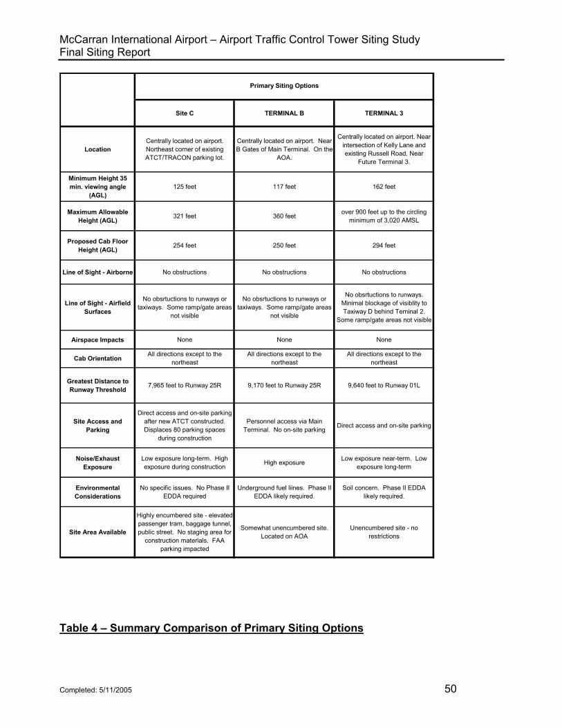
McCarran International Airport – Airport Traffic Control Tower Siting Study Final Siting Report
Site C TERMINAL B TERMINAL 3
LocationCentrally located on airport. Northeast corner of existing ATCT/TRACON parking lot.
Centrally located on airport. Near B Gates of Main Terminal. On the
AOA.
Centrally located on airport. Near intersection of Kelly Lane and existing Russell Road. Near
Future Terminal 3.
Minimum Height 35 min. viewing angle
(AGL)125 feet 117 feet 162 feet
Maximum Allowable Height (AGL) 321 feet 360 feet over 900 feet up to the circling
minimum of 3,020 AMSL
Proposed Cab Floor Height (AGL) 254 feet 250 feet 294 feet
Line of Sight - Airborne No obstructions No obstructions No obstructions
Line of Sight - Airfield Surfaces
No obsrtuctions to runways or taxiways. Some ramp/gate areas
not visible
No obsrtuctions to runways or taxiways. Some ramp/gate areas
not visible
No obsrtuctions to runways. Minimal blockage of visiblity to Taxiway D behind Teminal 2.
Some ramp/gate areas not visible
Airspace Impacts None None None
Cab Orientation All directions except to the northeast
All directions except to the northeast
All directions except to the northeast
Greatest Distance to Runway Threshold 7,965 feet to Runway 25R 9,170 feet to Runway 25R 9,640 feet to Runway 01L
Site Access and Parking
Direct access and on-site parking after new ATCT constructed. Displaces 80 parking spaces
during construction
Personnel access via Main Terminal. No on-site parking Direct access and on-site parking
Noise/Exhaust Exposure
Low exposure long-term. High exposure during construction High exposure Low exposure near-term. Low
exposure long-term
Environmental Considerations
No specific issues. No Phase II EDDA required
Underground fuel liines. Phase II EDDA likely required.
Soil concern. Phase II EDDA likely required.
Site Area Available
Highly encumbered site - elevated passenger tram, baggage tunnel, public street. No staging area for
construction materials. FAA parking impacted
Somewhat unencumbered site. Located on AOA
Unencumbered site - no restrictions
Primary Siting Options
Table 4 – Summary Comparison of Primary Siting Options
Completed: 5/11/2005 50

McCarran International Airport – Airport Traffic Control Tower Siting Study Final Siting Report
Site C TERMINAL B TERMINAL 3
Security Considerations
No interior setback. No exterior setback. ATCT structure
hardened for Wright Bros Lane and passenger tram
No interior setbacks. No exterior setbacks. ATCT in secured AOA
area
Some interior setback. No exterior setback. ATCT structure and
Base Building require hardening.
Possibility of Future Expansion None Expansion possible - dependant
upon TSA facility Expansion possible
Impact on Adjacent Land Use
None None None
Effect on FAA Electronics Facilities None None None
Availability of Utilities Available Available Available
Access to Fiber Optic Cable Loop
Easy access - cable loop will already encompass existing
ATCT/TRACON
Access available - cable loop will pass within 800 feet of site - ramp
pavement and fuel lines may cause difficulties
Access available - cable loop will pass within 1,700 feet of site -
water reservoir and compressed natural gas station may cause
difficulties
Risk Management
Potential to disrupt operations of existing ATCT/TRACON by
disturbing existing utilty line(s). Also, proximity of passenger tram
is a major concern; baggage tunnel to the east is a minor
concern
Very low risk to existing ATCT/TRACON. Risk to utilities
is low and localized, although Terminal 1 or TSA building could
be impacted. Risk to underground fuel lines is moderate.
Very low risk to existing ATCT/TRACON. Risk to utilities
is low and localized.
Primary Siting Options
Table 4 – Summary Comparison of Primary Siting Options (Continued)
Completed: 5/11/2005 51
McCarran International Airport – Airport Traffic Control Tower Siting Study Final Siting Report 5.3 Summary Cost Comparison of Primary Siting Options
Table 5 presents a summary cost comparison of the three primary siting options. Although the intent of the siting effort was to locate a suitable ATCT site, some very preliminary design and construction estimating was determined to be necessary to fully compare the validity of each potential site. The FAA budget justification states that a new ATCT shall be constructed on the existing site, thereby utilizing the existing Base Building for administration, operational, and ancillary support; however, the space available on the existing site for a new ATCT is very limited and will result in construction cost premiums. Constructing an ATCT on the AOA (Terminal B) site is expected to add a cost premium due to the badging requirements for the construction contractor, driving/escorting vehicles on the AOA, and potentially limited construction staging. If either the Terminal B or Terminal 3 site is selected as the final site, there are associated project costs that would not be required at Site C. Most notably, both of these sites would require the construction of a Base Building for administrative and ancillary support functions. To make a fully informed decision about the most suitable site for a new ATCT at McCarran Airport, the Project Team felt that relative construction costs should be considered as one of the determining factors.
• Cost of ATCT: The table indicates the expected ATCT height based on cab floor elevation, an estimated cost per vertical foot, and total estimated cost of the ATCT. The expected ATCT height was based on the ability to achieve complete visibility of airport movement areas. The estimated cost per vertical foot was averaged for several recent, larger ATCT projects around the country.
• Base Building: Necessity of constructing a Base Building adjacent to new ATCT to accommodate administrative and ancillary support functions.
• Cost of an adjacent Base Building: Where required, the table indicates the estimated total square footage, approximate cost per square foot, and total estimated cost of constructing a Base Building adjacent to the ATCT.
• Cost premiums: The cost premium associated with a particular site was determined by general industry standards, construction experience, and input from Jacobs Engineering (national FAA contractor). The cost premiums include site constraints/restrictions for an encumbered site, security requirements, and blast considerations.
The basic intent of Table 5 is to compare the relative costs of constructing a facility on any one of the three primary sites, not determine the actual construction costs at this early stage of the project. Although the budget justification states that a new ATCT shaft should be constructed on the existing ATCT/TRACON site, the premiums associated with that site drive the overall construction costs much higher. An ATCT constructed at the Terminal 3 site would require a taller shaft to achieve an acceptable
Completed: 5/11/2005 52

McCarran International Airport – Airport Traffic Control Tower Siting Study Final Siting Report
viewing height. Construction activities at the Terminal B Site would be complicated by its location on the AOA. When comparing the three options, including all of the additional costs and premiums, the construction costs for the Terminal B and Terminal 3 Sites are relatively the same. Even though these two sites would require the construction of a Base Building, their estimated costs are lower than the Terminal C Site.
Site C TERMINAL B TERMINAL 3
Proposed cab floor elevation (ft AGL) 260 250 289
Base Cost of ATCT ($50,000/vert. ft) $13,000,000 $12,500,000 $14,450,000
Base Building Required No Yes Yes
Estimated size of Base Building (SF) N/A 7,500 7,500
Base Cost of Base Building ($250/square ft) $0 $1,875,000 $1,875,000
Subtotal of Estimated Building Costs $13,000,000 $14,375,000 $16,325,000
30% 15% N/A
$3,900,000 $2,156,000 $0
No interior setback. No exterior setback. Elevated
tram. - 20 %
No interior setback. No exterior setback. On AOA. -
10%
Some interior setback. No exterior setback. - 10%
$2,600,000 $1,438,000 $1,632,500
Total Estimated Cost $19,500,000 $17,969,000 $17,958,000
Primary Siting Options
Premium for encumbered site
Premiums for security (harden structure due to
lack of setbacks)
Table 5 – Summary Cost Comparison of Primary Siting Options
Completed: 5/11/2005 53
McCarran International Airport – Airport Traffic Control Tower Siting Study Final Siting Report
5.4 Summary Comparison of Life Cycle Costs An important factor that must be considered during the site selection process is the long-term operations and maintenance, or life cycle, costs for each of the siting options. For the LAS ATCT project, three options must be considered to reasonably determine the impacts to the life cycle costs. The first option would be to construct a new ATCT at Site C and utilize the existing Base Building. The second option would be to construct a new ATCT and small Base Building on either the Terminal B or Terminal 3 Site and utilize the existing Base Building for the TRACON functions. The third option would be to construct a new ATCT and Base Building on the Terminal B or Terminal 3 site large enough to accommodate the TRACON functions so the entire facility could be relocated. For this report, the life cycle costs of the ATCT have been ignored because the shaft and cab would be approximately the same size at any of the potential siting options; therefore, the cost would be the same for any of the three sites.
5.4.1 ATCT Constructed at Site C A new ATCT constructed at Site C would utilize the existing Base Building and the overall life cycle costs for the facility would be expected to remain relatively the same. The existing Base Building measures approximately 20,000 square feet. At $12 per square foot per year (standard life cycle cost used by ATO - broken down as $3 per SF per year for building maintenance, repair and replacement, $6 per SF per year for utilities, and $3 per SF per year for janitorial costs), the expected yearly life cycle costs for the existing Base Building would be $168,000.
5.4.2 ATCT with 7,500 SF Base Building at the Terminal B or Terminal 3 Site The Terminal B and Terminal 3 Sites would each require the construction of a new Base Building for administrative and ancillary functions. This new space would be in addition to the existing Base Building that would have to remain operational for the TRACON functions. A 7,500 square foot Base Building would have estimated life cycle costs of approximately $90,000 per year (7,500 SF x $12/SF). This $90,000 of life cycle costs would be in addition to the $168,00 that would be required to maintain the existing Base Building. The total for both facilities would be about $258,000 per year.
5.4.3 ATCT with 20,000 SF Base Building at the Terminal B or Terminal 3 Site The last option that should be considered would be one in which both the ATCT and TRACON functions were moved to either the Terminal B or the Terminal 3 Site. If both functions were relocated, and the new Base Building was kept at 20,000 square feet, the life cycle costs would be expected to remain the same as the existing facility, which would be approximately $168,000 per year.
Completed: 5/11/2005 54
McCarran International Airport – Airport Traffic Control Tower Siting Study Final Siting Report
6. CONCLUSIONS AND RECOMMENDATIONS
6.1 Conclusions
6.1.1 Terminal B Site A review of the three primary siting options (Site C, Terminal B, and Terminal 3), by FAA and the Clark County Aviation Department, and consideration of the advantages and disadvantages of each potential siting option, led to the determination that the Terminal B Site should be eliminated from further consideration. Although an ATCT constructed at this site would offer excellent line-of-sight viewing to all airfield movement areas and airborne traffic patterns, the disadvantages associated with this site far outweigh the advantages. In the end, the proximity to the new TSA baggage screening facility, restricted AOA access, lack of personnel parking at the ATCT, the proximity of underground fuel lines, dissatisfaction with the site by the Clark County Aviation Department offices, and the probable exposure of the facility to aircraft noise and exhaust fumes were all prominent factors for eliminating the site.
6.1.2 Site C Due to the restrictions associated with Site C, Jacobs Engineering, Inc., as part of a national A/E contract, performed a construction feasibility study for the site. The combination of Wright Brothers Lane along the north, the baggage tunnel just to the east, and the elevated passenger tram along the west and south of the site creates and encumbered site that does not allow adequate space for crane operations, materials staging, and contractor parking. When all of these factors are combined, the cost of construction is driven as much as 30% higher than an open sight with adequate space to spread out construction activities. The Jacobs report, which is included in Appendix 3, also states that there is a major design conflict between the seismic (earthquake) and FAA blast requirements associate with Site C. Due to the close proximity of Wright Brothers Lane, which is a public street and would be less than 50 feet from the ATCT, the recommended exterior setback of 300 feet cannot be met. As a result, the ATCT shaft would have to be hardened against a potential blast event at Wright Brothers Lane. Experience shows that structural hardening would require the walls of the ATCT shaft to be thickened from around 12 inches to at least 30 inches. The structural modifications would create a very rigid, heavy building, and is in direct conflict with seismic design requirements. The expected ground accelerations and soil types for Las Vegas dictate that a steel-framed structure would be required because it would provide a lighter, more elastic (flexible) building, which are desirable features when contending with seismic loads. To mitigate the potential conflict of design requirements, the Project Team investigated a few alternatives. The first was to determine whether or not the blast criteria could be relaxed. As expected, Security informed the Project Team that the only alternative to meeting the setback distances was to mitigate the threat by hardening the structure;
Completed: 5/11/2005 55

McCarran International Airport – Airport Traffic Control Tower Siting Study Final Siting Report
therefore, we investigated the option of increasing the setback distance. The only feasible method of attaining this goal would have been to close Wright Brothers Lane to through-traffic, move the FAA perimeter fence to the north side of the street, and install an FAA gate/card reader on Wright Brothers Lane as far to the east as possible. The Clark County Aviation Department reviewed the proposal; however, they could not approve it because of the airport tenants and activities to the west of the FAA site. Other disadvantages associated with constructing an ATCT at Site C are the negative impact to FAA parking, higher risk to FAA and airport facilities/operations, increased construction costs to protect existing entities, and the lack of future expansion capability. Because of the magnitude of the disadvantages of utilizing Site C, especially the inability to design an ATCT structure capable of complying with both the seismic design requirements and the FAA blast criteria, it was determined that this site should be dropped from consideration as well.
6.2 Recommendations 6.2.1 Terminal 3 Site - Initial Conclusions
Based on the analysis and evaluation of this siting study, including the TERPS results, the AFTIL model/simulator, airspace studies, and a thorough review of the advantages and disadvantages of constructing a facility at the site, it was determined that relocating the LAS ATCT to the Terminal 3 Site would be the best alternative. The Terminal 3 Site would offer excellent line-of-sight viewing of all airborne traffic patterns and runways, as well as very good line-of-sight viewing of all ground movement areas. Although this site would require a taller ATCT shaft and a small Base Building for administrative and ancillary support functions, the relative construction costs would be less than constructing an ATCT shaft only at Site C. Constructing a new ATCT and Base Building at the Terminal 3 Site would increase the overall operations and maintenance (O & M) costs of the LAS ATCT and TRACON facilities by approximately $90,000 per year, assuming a 7,500 square foot Base Building was constructed to support the new ATCT. The $90,000 impact would be in addition to the estimated $240,000 in O & M costs currently needed to operate the existing 20,000 square foot Base Building. Accordingly, the initial conclusion of this siting study was that the new ATCT should be located at the Terminal 3 Site near the intersection of Russell Road and Kelly Lane. It was recommended that the ATCT be constructed with a cab floor elevation of 289 feet AGL (2,349 feet AMSL), which corresponds to a viewing height of 294 feet AGL (2,354 feet AMSL) and an overall height of 324 feet AGL (2,384 feet AMSL).
6.2.2 Mid-summer 2004 Developments, Impacts and Conclusions
In July of 2004 after the Siting Report was submitted for a 95% review by the Project Team, the FAA was informed of some late-developing changes to the Terminal 3
Completed: 5/11/2005 56

McCarran International Airport – Airport Traffic Control Tower Siting Study Final Siting Report
building plans by the Clark County Department of Aviation. They explained that the Terminal 3 building footprint was enlarged and that it had to be shifted further to the west. As a result of these changes, the size of the (primary) FAA site on the east side of Kelly Lane would have to be severely reduced, thus directly impacting the exterior setback distances, and limiting the future expansion capabilities of the site. At the same time, the Clark County Department of Aviation informed the FAA that the Terminal 3 Site located on the west side of Kelly Lane could be increased from the initial 1.5 acres to about 3.5 acres, see Figure 4. Whereas the original 1.5 acres was not adequate, the revised plot size on the west side of Kelly Lane would accommodate increased setback distances as well as future expansion. In addition, the Aviation Department advised FAA that Kelly Lane would be removed as part of the Terminal 3 building construction so the west Terminal 3 Site would abut the AOA on the east and south sides of the property. Because the AOA is inherently a secure area, the new ATCT and Base Building could be constructed on the southern portion of the site, thus moving it further away from public streets, and thereby further improving setback distances. After the FAA was informed of the Terminal 3 building changes, it was decided by the Project Team that a trip back to the AFTIL would be necessary to confirm viewing heights and determine the best location for the ATCT within the revised property boundaries of the west Kelly Lane site. Air Traffic (AWP-510, LAS AT, and LAS NATCA) and ANI-540 traveled to Atlantic City during the week of July 26, 2004 to assess the impacts of moving the Terminal 3 Site. It was determined that by moving the ATCT site to the west side of Kelly Lane, the line of sight was improved to Taxiway D behind Terminal 2 and the visibility impact of the existing ATCT from the new cab was reduced. The AFTIL model/simulator clearly showed that the further west that the new ATCT was moved, the better overall visibility improved. Based on the information obtained from the Clark County Department of Aviation in July of 2004, and the results of the AFTIL model/simulator visit, the recommendation was revised, thus moving the Terminal 3 Site from the east side of Kelly Lane to the west side of Kelly Lane. At the time, it was also recommended that the cab height remain at 289 feet AGL (2,349 feet AMSL), which corresponded to a viewing height of 294 feet AGL (2,354 feet AMSL) to maximize visibility to all areas of the airport. A letter from the Western Pacific Air Traffic Division (AWP-510), providing the rationale and justification for this 294-foot AGL eye height, is included in Appendix 4.
Completed: 5/11/2005 57
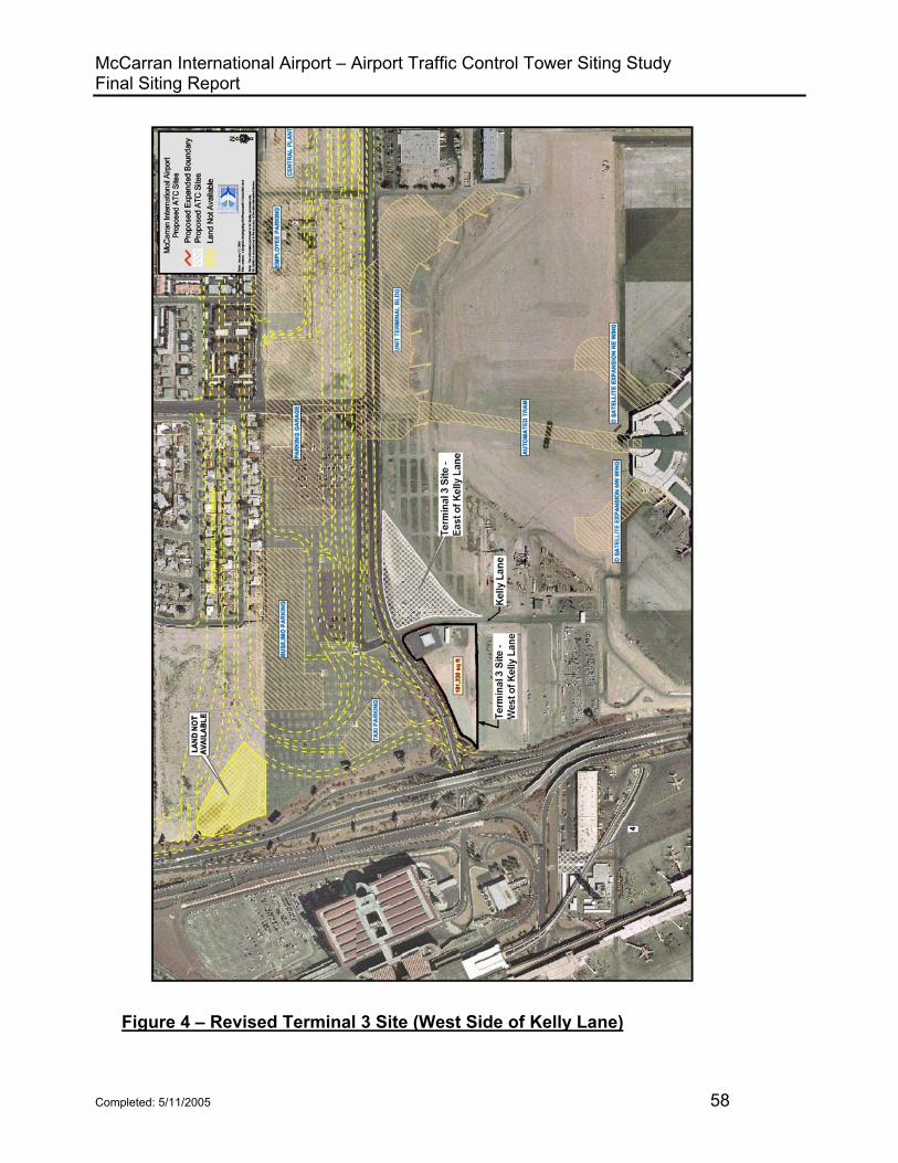
McCarran International Airport – Airport Traffic Control Tower Siting Study Final Siting Report
Figure 4 – Revised Terminal 3 Site (West Side of Kelly Lane)
Completed: 5/11/2005 58

McCarran International Airport – Airport Traffic Control Tower Siting Study Final Siting Report
6.2.3 Late-fall 2004 Developments, Impacts, and Conclusions
There were three additional developments in fall of 2004 that further impacted the siting process for this control tower. The first was the realization that a 54-inch water line is located on the southern edge of the Terminal 3 Site on the west side of Kelly Lane. The second was the construction of a new baggage screening facility near the existing Terminal 2 building. Both of these developments have the potential to cause both fiscal and schedule impacts to the project. Lastly, the Clark County DOA plans to construct a “sky bridge” that connects the B Gates and C Gates of Terminal 1. Shortly after the Terminal 3 Site west of Kelly Lane was selected as the primary location for the new ATCT, a meeting was scheduled with the Clark County DOA to brief them on the decision. During the meeting, one of the DOA attendees from the Planning Department informed the group that a 54-inch water line ran through the southern portion of the site. Rather than locating the new ATCT in the southeastern portion of the site as initially planned, the tower would have to be moved further north around 75 to 100 feet. This adjustment in the location on the site would not impact the line-of-sight from the new tower cab to the airport movement areas; however, it would reduce the amount of security setback distance from the existing public street that borders the northern edge of the site. To reduce or possibly eliminate the impact, the FAA is coordinating with the Clark County DOA to relocate the water line The Safety Management System (SMS) exercise for the LAS ATCT was scheduled for November 18, 2004 at the AFTIL in Atlantic City, NJ. About a week before the exercise, the local air traffic office noticed some construction activity for a new structure just north of the existing Terminal 2 building and inquired about the building dimensions and usage. The Clark County DOA informed FAA that the new building was a TSA baggage screening facility for Terminal 2. Unfortunately, the height of the structure and close proximity to Taxiway D created a line-of-sight issue from the existing ATCT, and there was concern there would be a similar problem from the proposed Terminal 3 Site. The DOA provided the building statistics and they were forwarded to the AFTIL. The AFTIL modeled the building so the Project Team could evaluate the impacts from each of the potential ATCT sites during the SMS exercise. The tower cab at the Terminal 3 Site west of Kelly Lane had to be raised 48 feet inside the model/simulation to be able to establish the minimum acceptable line-of-sight to Taxiway D behind the new baggage screening building. The new height is not expected to impact any TERPS surfaces; however, the construction costs are expected to increase about $3.0M from $17.958M, as identified in Table 5, to $21.958M. Although the cost impact is rather severe, the Terminal 3 Site west of Kelly Lane has emerged as the only viable site on the airport for the construction of a new ATCT. As mentioned earlier, an ATCT constructed at Site C would be too close to Wright Brothers Lane and would require substantial blast hardening, which would directly conflict with the seismic requirements at the site. In late November 2004, the FAA learned that the Clark County DOA intends to construct a sky bridge from the B Gates
Completed: 5/11/2005 59
McCarran International Airport – Airport Traffic Control Tower Siting Study Final Siting Report
to the C Gates of Terminal 1 to accommodate Southwest Airlines’ growing demand for gate space. The sky bridge will allow the Southwest Airlines passengers with connecting flights to travel directly between the B Concourse and C Concourse without exiting the secured area and having to be screened by security to re-enter. The location of the new sky bridge will virtually eliminate the possibility of constructing a new ATCT at the proposed Terminal B Site.
It is recommended that the ATCT height be increased to maximize the line-of-sight visibility to Taxiway D behind the new TSA baggage screening facility. The new cab height will be 337 feet AGL (2,397 AMSL) and the overall structure height will be 372 feet AGL (2,432 AMSL). It is further recommended that the Clark County Aviation Department, prior to the start of construction for the new ATCT, decommission, remove, and remediate the compressed natural gas refueling station that is located on the site. It is further recommended that a Safety Management System (SMS) report be completed for the LAS ATCT siting process. After completion, the SMS Report will be included in Appendix 6 of this Final Siting Report. It is also recommended that the new ATCT be placed as far west on the west site as possible taking into consideration security setback distances, future expansion capabilities, and overall site development and utilization. Depending on the results of the water line relocation study that the DOA is performing, the ATCT will be located as far south on the property as possible to maximize security setbacks to the extent possible. A new Airspace Study (Standard FAA Form 7460-1, Notice of Proposed Construction or Alteration) was submitting in December 2004 for the site on the west side of Kelly Lane with a new ATCT height of 375’ AGL. The associated determination letter, along with the determination letter for the initial sites, is included in Appendix 5. It is recommended that the ATCT include red obstruction lighting. Based on preliminary TERPS evaluation, no TERPS surfaces will be impacted by constructing an ATCT at a height of 375 feet AGL at the Terminal 3 Site west of Kelly Lane. (Note: The controlling surfaces for TERPS are generated by the CAT I ILS on Runway 25R)
6.2.4 Safety Management System (SMS)
A Comparative Safety Assessment (CSA) has been completed for the LAS ATCT siting. The results of the CSA, which are captured in the Safety Risk Management (SRM) Document, are included in the final report in Appendix 6. The FAA Safety Management System (SMS) Manual defines the process for conducting the CSA in order to ensure the ATCT siting process complies with the goals and objectives of the FAA SMS Manual. Representatives from the Siting Team, including Air Traffic, NATCA, and ANI, participated in the SMS exercise at the AFTIL in Atlantic City, and
Completed: 5/11/2005 60
McCarran International Airport – Airport Traffic Control Tower Siting Study Final Siting Report
the model/simulation was utilized to assess the various hazards at the different sites. A Preliminary Hazard List (PHL) was used to identify the safety hazards associated with each of the three primary siting options. Hazard analysis worksheets were utilized to document the severity of the consequences and the likelihood of occurrence for the different hazards. After each site was evaluated, the hazards were compared using a Risk Matrix for relative hazard ranking. For the purposes of applying SMS to the ATCT siting process, the CSA only considered hazards that may impact aviation safety. As summarized in the SRM Document in Appendix 6, the Terminal 3 Site has the lowest relative safety risk ranking; therefore, it has the most favorable safety profile of all three of the primary sites. The Terminal 3 Site has no high-risk hazards, no medium-risk hazards, and 16 low-risk hazards. The Terminal B site had one high-risk hazard, no medium-risk hazards, and 15 low-risk hazards, while Site C had no high-risk hazards, one medium-risk hazard, and 15 low-risk hazards. For the purposes of SMS, the low-risk hazards need to be documented, but do not have to be mitigated and tracked to closure like the medium and high hazards.
Completed: 5/11/2005 61

THIS PAGE INTENTIONALLY LEFT BLANK

Appendix 1 – List of Contacts

Mike Loghides Airport Program Administrator Department of Aviation P.O. Box 11005 McCarran International Airport Las Vegas, NV 89111-1005 Tel: 702-261-5750 Sally Savage-Lebhart Manager, Terminal Business Service P.O. Box 92007 Los Angeles, CA 90009-2007 Tel: 310-725-3535 John O’Leary (NISC) Air Traffic Requirements Branch, AWP-510 P.O. Box 92007 Los Angeles, CA 90009-2007 Tel: 310-725-6621 Sallyanne Rice ATCT Air Traffic Manager (Acting) 699 Wright Brothers Lane Las Vegas, NV 89119 Tel: 702-262-5932 Jon Holman Air Traffic Operations Manager 699 Wright Brothers Lane Las Vegas, NV 89119 Tel: 702-262-5983 David Spencer Facility Manager Southern Nevada System Support Center 699 Wright Brothers Lane Las Vegas, NV 89119 Tel: 702-262-5977
Kent Freeman Terminal Platform Supervisor, ANI-940 Los Angeles Implementation Center P.O. Box 92007 Los Angeles, CA 90009-2007 Tel: 310-725-7642 Ed Felipe Program Manager, ANI-940 Los Angeles Implementation Center P.O. Box 92007 Los Angeles, CA 90009-2007 Tel: 310-725-3498 Jim Adelman Terminal Platform Supervisor, ANI-540 Kansas City Implementation Center 901 Locust St. – Room 230 Kansas City, MO 64106 Tel: 816-329-3541 Tom Frakes Program Manager, ANI-540 Kansas City Implementation Center 901 Locust St. – Room 230 Kansas City, MO 64106 Tel: 816-329-3537 Darren Brinker Lead Project Engineer, ANI-540 Kansas City Implementation Center 901 Locust St. – Room 230 Kansas City, MO 64106 Tel: 816-329-3541

Appendix 2 – Shadow Diagrams for Existing ATCT and Primary Siting Options
Existing ATCT – 185 feet AGL Viewing Height Site C – 200 feet AGL Viewing Height Site C – 265 feet AGL Viewing Height Terminal B – 200 feet AGL Viewing Height Terminal B – 254 feet AGL Viewing Height Terminal 3 – 250 feet AGL Viewing Height Terminal 3 – 294 feet AGL Viewing Height


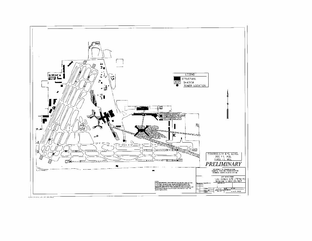


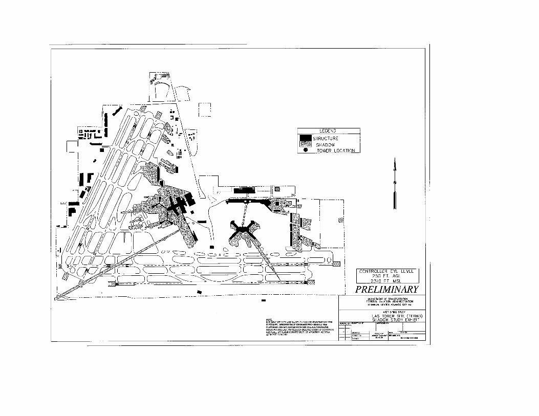


Appendix 3 – Jacobs Engineering Construction Feasibility Study for Site C


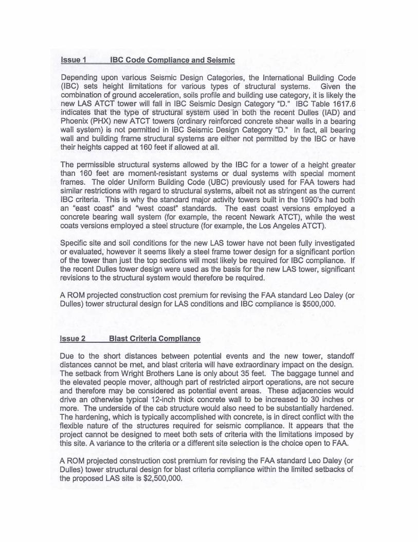


Appendix 4 – Coordination Letters
December 15, 2003 – Clark County Department of Aviation (2 pages)
Letter from the Department of Aviation that identifies the available ATCT sites on the airport. It identifies the two Kelly Lane sites (#2 and #3) as well as the Terminal B (#1) site as viable options. It also eliminates the Russell Road site (area to the northwest of the bus/limo parking) from consideration. Since the Sunset Road site is off-airport property, it is not identified here as a viable option; however, it was under consideration at the time this letter was written. The attached sketch depicts the approximate property boundaries of the various potential sites. Of the two Terminal 3 sites shown, the site on the east side of Kelly Lane (#3) was the preferred location because of its larger size.
February 2004 – Clark County Department of Aviation (2 pages)
As a routine procedure, the various offices within the Clark County Department of Aviation conduct a review of all proposed projects that will affect the airport. This document was received in February of 2004 and addresses the various potential sites that were under consideration at that time. The Terminal B site is the only site specifically discussed, and all of the comments are negative.
July 23, 2004 – Clark County Department of Aviation (2 pages)
This letter from the Clark County Department of Aviation discusses recent changes to the Terminal 3 building design that will reduce the size of the Kelly Lane site east of Kelly Lane (Site 3). It also confirms that the Department of Aviation is willing to increase the size of the Terminal 3 site west of Kelly Lane (Site 2) to 165,800 square feet (3.8 acres) from its original 1.5 acres. Lastly, the letter discusses the Sunset Road site and the fact that the rising cost of real estate in the Las Vegas area has made the site unattainable for the Aviation Department. The attached sketch depicts the proposed changes to the site on the west side of Kelly Lane
October 4, 2004 – Area Director, Western Terminal Operations
This letter from the Western Terminal Operations office provides the explanation and justification for a minimum eye height of 294 feet AGL for the new ATCT.


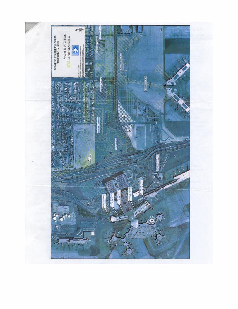


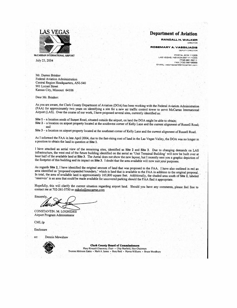


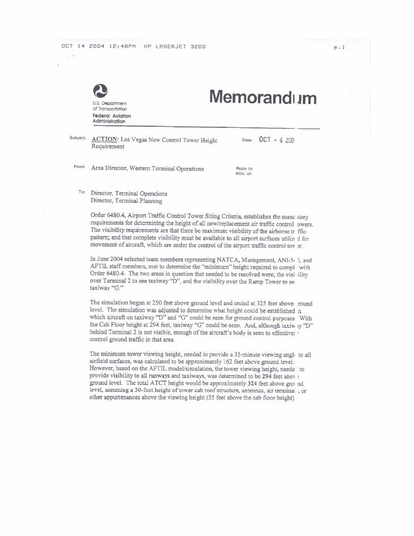


Appendix 5 – Airspace Study Determination Letters
March 19, 2004 – FAA via Clark County Department of Aviation (2 pages) This letter was generated by the San Francisco Airports District Office and forwarded to the Director of Aviation at McCarran Airport. The letter discusses the results of the initial airspace studies that were requested for each potential site. The letter does not identify any objections with any of the sites; however, it reiterates the concerns of the Airport personnel concerning the Terminal B site.
March 24, 2005 – FAA via Clark County Department of Aviation (2 pages) This letter was generated by the San Francisco Airports District Office and forwarded to the Director of Aviation at McCarran Airport. The letter discusses the results of the follow-up airspace study that was requested for the Terminal 3 Site west of Kelly Lane with an estimated overall structure height of 357 feet AGL. The letter does not identify any objections with any of the sites; however, it recommends lowering construction equipment at night and providing red obstruction lighting on the building.


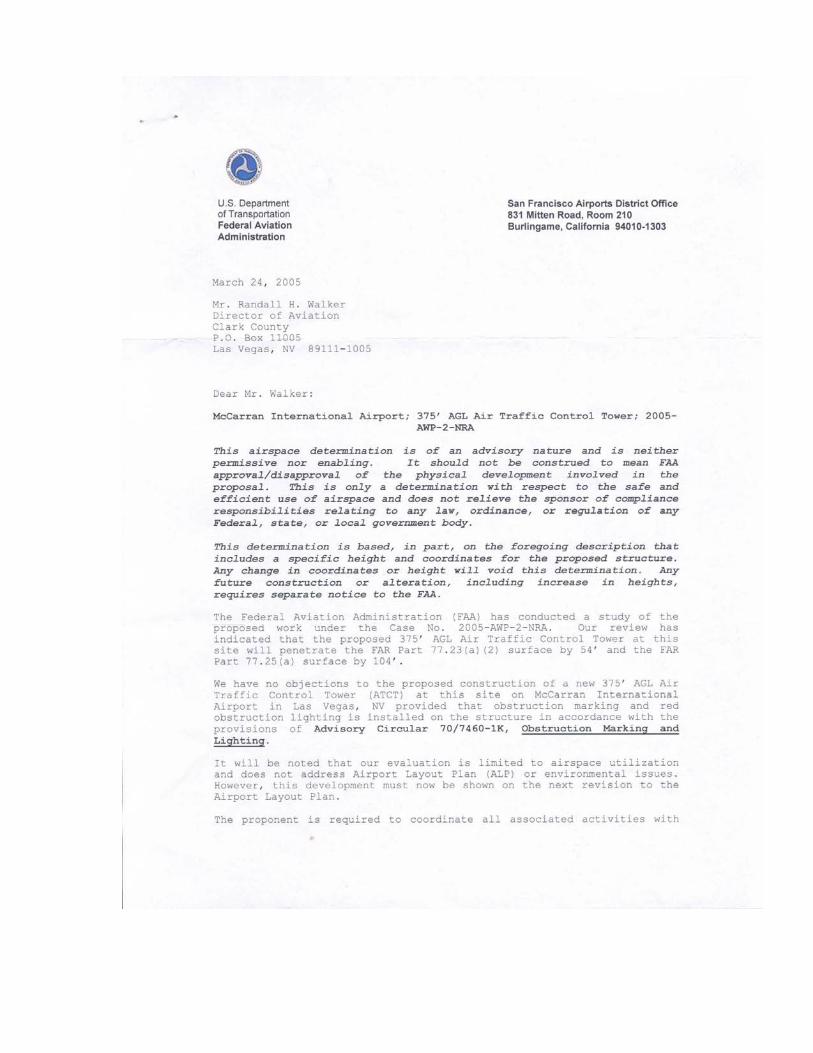


Appendix 6 – Safety Management System (SMS) Report