merthyr tydfil - cadw.gov.walescadw.gov.wales/.../150428merthyrurbancharacter-en.pdf · cyfarthfa...
TRANSCRIPT

Merthyr Tydfil: Understanding Urban Character
CadwWelsh GovernmentPlas CarewUnit 5/7 Cefn CoedParc NantgarwCardiff CF15 7QQ
Telephone: 01443 33 6000Email: [email protected]
First published by Cadw in 2015Print ISBN 978 1 85760 323 1Digital ISBN 978 1 85760 325 5© Crown Copyright 2015 WG21573
This publication is licensed under the terms of the Open Government Licence v3.0 except where otherwise stated. To view this licence, visit http://www.nationalarchives.gov.uk/doc/open-government-licence/version/3 or write to the Information Policy Team, The National Archives, Kew, London TW9 4DU, or e-mail: [email protected]
Where third party material has been identified, permission from the respective copyright holder must be sought, including Alan George’s Old Merthyr Tydfil, Cadw, Cyfarthfa Castle Museum and Art Gallery, Llyfrgell Genedlaethol Cyrmu / National Library of Wales, Ordnance Survey, Ordnance Survey and Landmark Information Group Ltd, Royal Commission on the Ancient and Historical Monuments of Wales and The Francis Frith Collection.
Cadw is the Welsh Government’s historic environment service, working for an accessible and well-protected historic environment.
www.cadw.wales.gov.uk/learn-ing

Cadw is the Welsh Government’s historic environment service, working for an accessible and well-protected historic environment.
CadwWelsh GovernmentPlas CarewUnit 5/7 Cefn CoedParc NantgarwCardiff CF15 7QQ

1
Merthyr Tydfil: Understanding Urban Character

2
AcknowledgementsThe Royal Commission on the Ancient and Historical Monuments of Wales (RCAHMW) provided the photography for this study. Cadw also wishes to acknowledge the help of Jana Horák and John Davies, Department of Geology, Amgueddfa Cymru — National Museum Wales in preparing a report on building stone in Merthyr Tydfil, and Carolyn Jacob, formerly the Reference and Information Librarian for Merthyr Tydfil Public Library Services.

3
Contents
Introduction 5Aims of the Study 5
Historical Background 6Before Industrialization Took Hold 6The Foundations of Industrial
Development 12Industrial Expansion: The Creation of
an Industrial Landscape 14The Decline of Iron; the Rise of Coal 19Transport 20That Metropolis of Iron Masters:
Merthyr Tydfil Becomes a Town 24Civic Life, Politics and Society 35Loss and Renewal:
The Twentieth Century 38
Historical Topography 41The Landscape of Industry 41Settlement Patterns 42
The Character of Building 46Building Materials 46 Pennant Sandstone 46 Farewell Rock 47 Basal Grit 47 Carboniferous Limestone 47 Old Red Sandstone 48
The Chronology of Building 48Building Styles 49 Domestic Building 49 Commercial Building 52Historical Associations 53
Character Areas 541. Town Centre: High Street and
Pontmorlais 542. Thomastown and Penyard 593. Twynyrodyn, including Ysgubor Newydd
and Penyrheol 634. South of the Town Centre:
Plymouth Street Area 655. Cyfarthfa: Park and Ironworks 656. Williamstown, Cae Pant Tywll and
Morgantown 687. Penydarren 708. Georgetown and Ynysfach 77 9. West Merthyr, including Heolgerrig
and Gellideg 78
Statement of Significance 79
Selected Sources 80
Endnotes 82
1. All Character Areas with Historic Environment Designations
2. All Character Areas
3. Town Centre: High Street and Pontmorlais (1)
4. Thomastown and Penyard (2)
5. Twynyrodyn, including Ysgubor Newydd and Penyrheol (3)
6. South of the Town Centre: Plymouth Street Area (4)
7. Cyfarthfa: Park and Ironworks (5)
8. Williamstown, Cae Pant Tywll and Morgantown (6)
9. Penydarren (7)
10. Georgetown and Ynysfach (8)
11. West Merthyr, including Heolgerrig and Gellideg (9)
List of Maps pages 84–94

MERTHYR TYDFIL: UNDERSTANDING URBAN CHARACTER
44

MERTHYR TYDFIL: UNDERSTANDING URBAN CHARACTER
5
Aims of the Study
Historic character lies at the heart of local distinctiveness and sense of place. No two places share a history, so every place has a unique historic character, which is a powerful asset in regeneration; sustaining it can bring social, economic and environmental benefits.
Urban characterization is a tool that can help us use historic character to create sustainable and distinctive places for the future. It aims to describe and explain the historic character of towns, to give a focus to local distinctiveness and help realize the full value of the historic environment. It seeks to inform and support positive planning, regeneration and conservation programmes, help improve the quality of planning
advice, and contribute to local interpretation and education strategies.
Urban characterization defines the unique historic character of individual towns and identifies the variety of character within them. It looks at the history of a town and identifies how this is expressed in patterns of space and connection and in traditions of building, which are the fundamental ingredients of historic character and local distinctiveness.
The immediate purpose of this study is to inform a range of regeneration initiatives in Merthyr Tydfil, including a proposed Townscape Heritage Initiative in the town centre. The study also examines the historic character of much of the surrounding area in an integrated approach intended to provide a baseline for strategic planning as well as local management.
5
Introduction
Cyfarthfa Ironworks, Merthyr Tydfil (Alan George’s Old Merthyr Tydfil).
MERTHYR TYDFIL: UNDERSTANDING URBAN CHARACTER
6
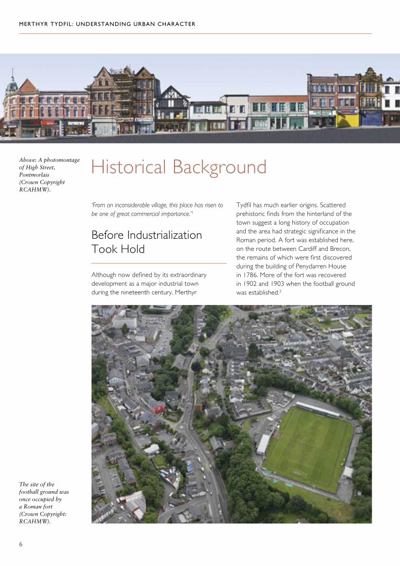
Tydfil has much earlier origins. Scattered prehistoric finds from the hinterland of the town suggest a long history of occupation and the area had strategic significance in the Roman period. A fort was established here, on the route between Cardiff and Brecon, the remains of which were first discovered during the building of Penydarren House in 1786. More of the fort was recovered in 1902 and 1903 when the football ground was established.2
Historical Background
‘From an inconsiderable village, this place has risen to be one of great commercial importance.’1
Before Industrialization Took Hold
Although now defined by its extraordinary development as a major industrial town during the nineteenth century, Merthyr
Above: A photomontage of High Street, Pontmorlais (Crown Copyright RCAHMW).
The site of the football ground was once occupied by a Roman fort (Crown Copyright: RCAHMW).

MERTHYR TYDFIL: UNDERSTANDING URBAN CHARACTER
7
Above: Although the church we see today is a nineteenth-century building, it occupies the site of an earlier structure and is a link to medieval Merthyr Tydfil (Crown Copyright: RCAHMW).
Left: The haphazard street pattern around the church, shown in this extract from the 1875 first edition Ordnance Survey map, was probably also a legacy of early settlement.
The church of St Tydfil is a known medieval site associated, by dedication, to Tydfil, daughter or granddaughter of Brychan Brycheiniog, descended from kings of south Wales. There is a tradition that she was martyred here, though the place name element ‘Merthyr’ simply denotes a consecrated site. There is no secure evidence for a very early church, but Charles Wilkins suggests that Merthyr Tydfil had been established as a parish by about 1270.3
Depictions of the building that preceded the present structure suggest that the first stone church may have been fourteenth century. The church came to serve as the nucleus of a small settlement: the haphazard arrangement of roads and plots of land to the south and east of the church, recorded on maps before redevelopment in the mid-twentieth century, was probably a legacy of early settlement growth here.4
MERTHYR TYDFIL: UNDERSTANDING URBAN CHARACTER
8
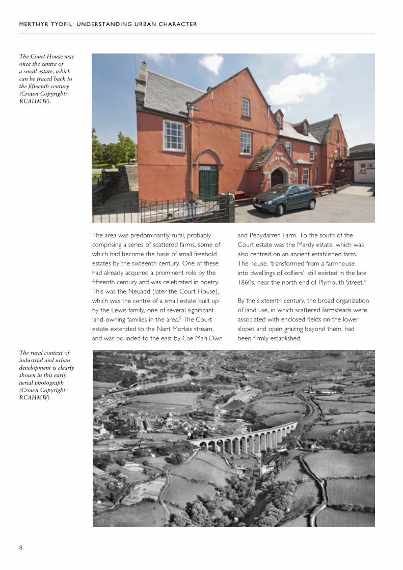
The area was predominantly rural, probably comprising a series of scattered farms, some of which had become the basis of small freehold estates by the sixteenth century. One of these had already acquired a prominent role by the fifteenth century and was celebrated in poetry. This was the Neuadd (later the Court House), which was the centre of a small estate built up by the Lewis family, one of several significant land-owning families in the area.5 The Court estate extended to the Nant Morlais stream, and was bounded to the east by Cae Mari Dwn
and Penydarren Farm. To the south of the Court estate was the Mardy estate, which was also centred on an ancient established farm. The house, ‘transformed from a farmhouse into dwellings of colliers’, still existed in the late 1860s, near the north end of Plymouth Street.6
By the sixteenth century, the broad organization of land use, in which scattered farmsteads were associated with enclosed fields on the lower slopes and open grazing beyond them, had been firmly established.
The Court House was once the centre of a small estate, which can be traced back to the fifteenth century (Crown Copyright: RCAHMW).
The rural context of industrial and urban development is clearly shown in this early aerial photograph (Crown Copyright: RCAHMW).
MERTHYR TYDFIL: UNDERSTANDING URBAN CHARACTER
9
Eventually, agriculture played a subordinate role to industry, and landholdings were primarily exploited for the value of their mineral resources. The mineral leases that supported the development of the iron industry granted rights to below-ground resources, and the ironmasters also leased or bought the farms themselves as a means of controlling and exploiting the land surface. Wilkins noted that ‘about twenty farms were swallowed up by the Cyfarthfa works’.9 Some farms were retained for agriculture but were adapted into more efficient holdings better equipped to deal with the needs of a growing population. Gurnos Farm and Pandy Farm are good examples of farms remodelled for the Cyfarthfa estate in the early nineteenth century.
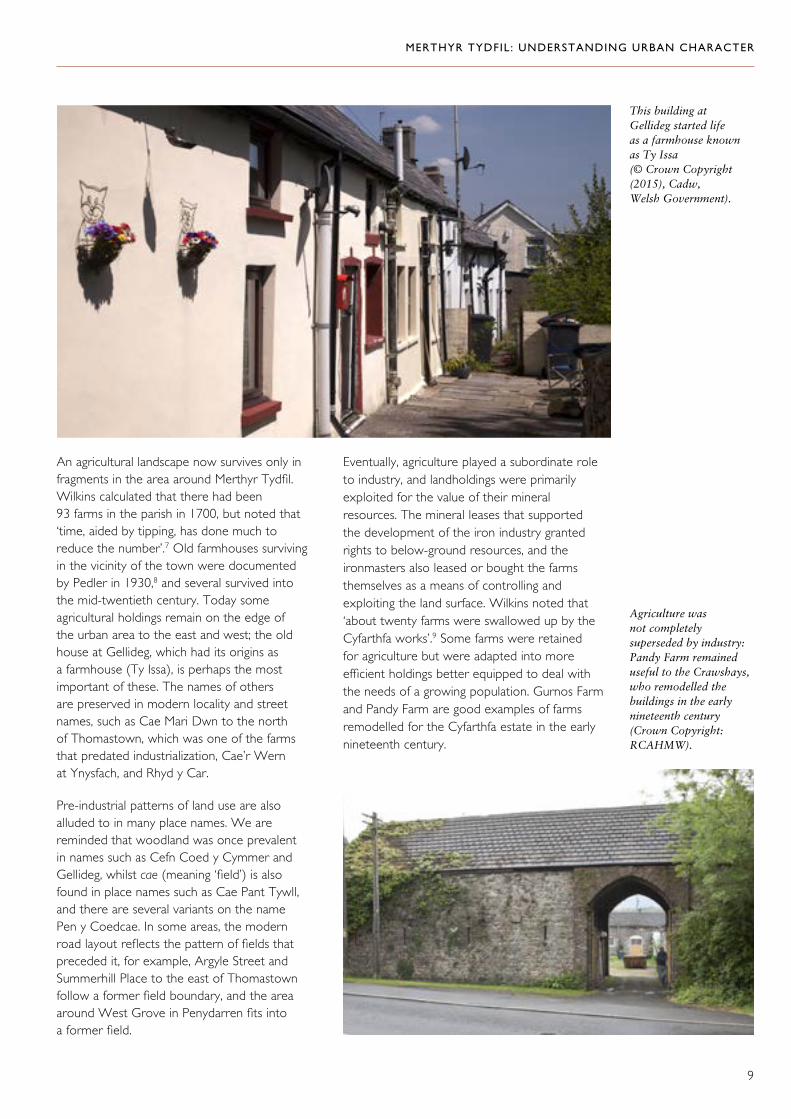
This building at Gellideg started life as a farmhouse known as Ty Issa (© Crown Copyright (2015), Cadw, Welsh Government).
An agricultural landscape now survives only in fragments in the area around Merthyr Tydfil. Wilkins calculated that there had been 93 farms in the parish in 1700, but noted that ‘time, aided by tipping, has done much to reduce the number’.7 Old farmhouses surviving in the vicinity of the town were documented by Pedler in 1930,8 and several survived into the mid-twentieth century. Today some agricultural holdings remain on the edge of the urban area to the east and west; the old house at Gellideg, which had its origins as a farmhouse (Ty Issa), is perhaps the most important of these. The names of others are preserved in modern locality and street names, such as Cae Mari Dwn to the north of Thomastown, which was one of the farms that predated industrialization, Cae’r Wern at Ynysfach, and Rhyd y Car.
Pre-industrial patterns of land use are also alluded to in many place names. We are reminded that woodland was once prevalent in names such as Cefn Coed y Cymmer and Gellideg, whilst cae (meaning ‘field’) is also found in place names such as Cae Pant Tywll, and there are several variants on the name Pen y Coedcae. In some areas, the modern road layout reflects the pattern of fields that preceded it, for example, Argyle Street and Summerhill Place to the east of Thomastown follow a former field boundary, and the area around West Grove in Penydarren fits into a former field.
Agriculture was not completely superseded by industry: Pandy Farm remained useful to the Crawshays, who remodelled the buildings in the early nineteenth century (Crown Copyright: RCAHMW).

MERTHYR TYDFIL: UNDERSTANDING URBAN CHARACTER
10
Gurnos Farm from the air (Crown Copyright: RCAHMW).
Gurnos Farm, as depicted by Penry Williams, 1802–85 (Photograph reproduced with the kind permission of Cyfarthfa Castle Museum and Art Gallery, Merthyr Tydfil).
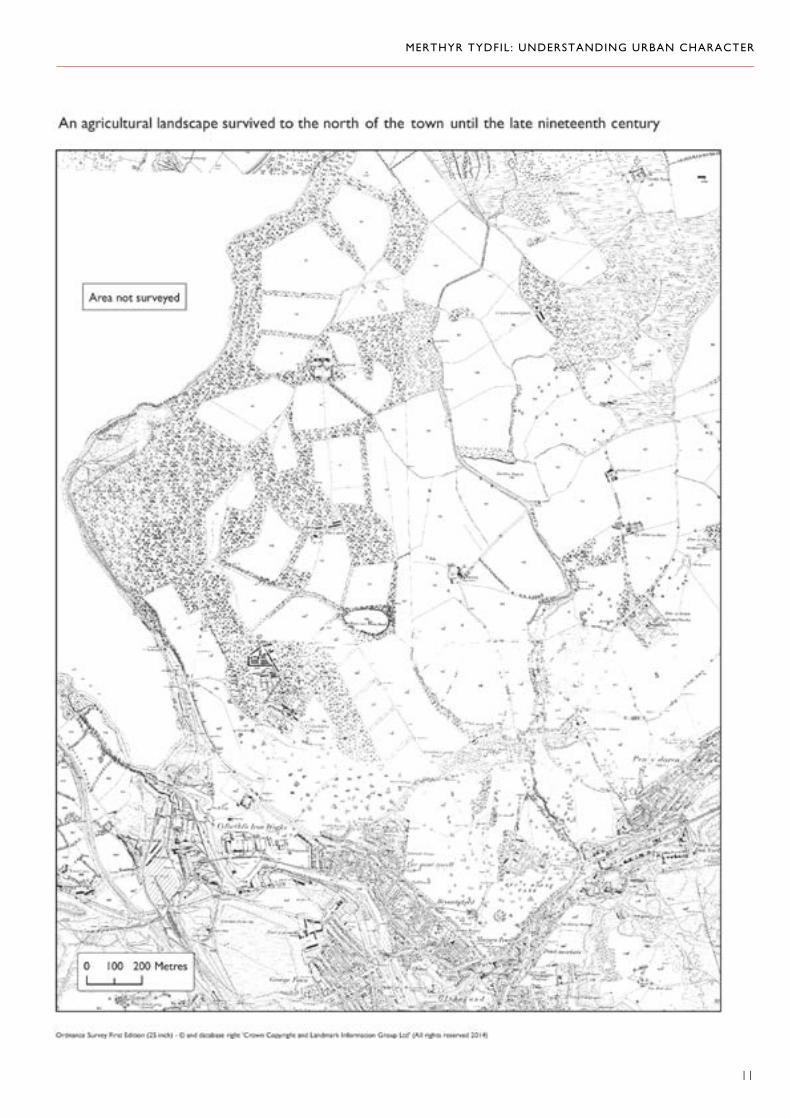
An agricultural landscape survived best (until urban development began to encroach in the late nineteenth century) to the north, around Cyfarthfa Castle and Penydarren House, where a
landscape of fields and plantations with scattered houses and farms was retained by the two ironworks’ estates, and is recorded on the first edition Ordnance Survey map of 1875.
MERTHYR TYDFIL: UNDERSTANDING URBAN CHARACTER
11

MERTHYR TYDFIL: UNDERSTANDING URBAN CHARACTER
12
The Foundations of Industrial Development
The mineral resources of the area had been exploited since at least the sixteenth century, and early iron-working sites have been recorded at Pontygwaith, Troedyrhiw, Dyffryn and Blaencanaid.10 However, this early industrial activity was small in scale and could be accommodated within an essentially rural pattern of land use until much greater investment and exploitation began in the second half of the eighteenth century.
One of the prerequisites for significant industrial development was a geology in which the raw materials necessary for iron production — coal, ironstone and limestone — were available and accessible. The particular succession of rocks in the South Wales Coalfield contained all the raw materials necessary for iron production: Carboniferous Limestone (the flux in casting), Millstone Grit (the source of silica sands for brick making) and coal and ironstone. These resources were closest to the surface, therefore more readily accessible, in the north of the region. Accessibility was made even easier in the Merthyr Tydfil area because the action of the river Taff and its tributaries exposed the strata, and also provided a ready source of water power.
Limestone quarries at Morlais (top) and Vaynor (bottom) (Crown Copyright: RCAHMW).

MERTHYR TYDFIL: UNDERSTANDING URBAN CHARACTER
13
Cyfarthfa Ironworks, as depicted by William Pamplin between 1791 and 1800 (Photograph reproduced with the kind permission of Cyfarthfa Castle Museum and Art Gallery, Merthyr Tydfil).
Exploitation of these plentiful raw materials required rights over land and capital to invest. The entrepreneurs who established the four major ironworks in the Merthyr Tydfil area all came from England, bringing English capital with them, and each of the works was centred on a considerable landholding. This land take was vital: everything from water supply through to the tipping of waste and the transport of raw materials and finished products was land hungry.
Dowlais was the first major ironworks to be established here. Thomas Lewis acquired mineral rights in 1757, but it was the Guest family who took over its management in 1759 and who were primarily responsible for the rapid development of the works. Dowlais was at the forefront of iron-making technology for some time; it was one of the first to introduce steam power and went on to pioneer the use of the Bessemer process for steel production in 1865. The original lease from the estate of the earls of Pembroke (part of the Bute estate) granted mineral rights over an extensive tract of land on the western slopes of Merthyr Common to the north and east of the works. This lease, a mere £26 a year, supported the growth of an ironworks that was the biggest in the world in 1846, when it employed 7,000 people.
Its profit in the following year was £172,746. The Ivor works was established as an offshoot of Dowlais in the boom years of the 1830s.
Cyfarthfa was to be the other major ironworks in the area, established in 1765 by Anthony Bacon, but eventually acquired by Richard Crawshay in 1794. By 1798, some £100,000 had already been invested in Cyfarthfa.11 Cyfarthfa too subsequently set up a secondary works at Ynysfach in 1801, and was the largest works in Britain in 1803. It pioneered Cort’s puddling process from 1784 and used steam power from the 1780s. The original lease comprised 4,000 acres (1,618.7 hectares) of land — a tract about 8 miles long and 5 miles wide (13km by 8km) — at a rent of £100 per year from the Dinefwr estate. The 99-year lease was negotiated in 1765 for the sole supply of the ironworks, and the first furnace was completed in 1767. In addition to the mineral lease, the farms that worked the land surface also had to be controlled, and Bacon and his successors bought out the small farmers wherever they could. Most of this land lay to the west of the river Taff and provided the iron ore and coal for the furnaces, as well as some building stone; the limestone came from Gurnos to the north. When Richard Crawshay died in 1810, he was one of the first millionaires in Britain.

MERTHYR TYDFIL: UNDERSTANDING URBAN CHARACTER
14
Penydarren Ironworks, as depicted by John George Wood in 1811 (By permission of Llyfrgell Genedlaethol/National Library of Wales).
The Plymouth Ironworks was established in 1763 by Isaac Wilkinson and John Guest on land leased from the earl of Plymouth. Anthony Bacon took it over in 1765 and sold it to Richard Hill in 1783, in whose family it remained until 1862. It had holdings on both sides of the Taff: on Mynydd-cilfach-yr-encil to the east (from Cwm Blacks and Clyn-mil to Troedyrhiw) and at Gethin and Graig on the west.
Finally, the Penydarren works was established by Francis Homfray in 1784. It was dependent on a lease of the 80-acre (32.3-hectare) Penydarren Farm, which was said to be full of coal and iron ore. Eventually, as these riches were worked, ‘all the hedges and fences of the farm have been destroyed by these operations, and the entire surface has been cut up and rendered useless for agricultural purposes.’12 This was the area around Incline Top, Penyard and Cae Mari Dwn. The land to the north of the ironworks, by contrast, remained in agricultural use until it was developed for housing at the end of the nineteenth century.
Industrial Expansion: The Creation of an Industrial Landscape
These four ironworks were the basis for the creation of an industrial and urban landscape, and the phenomenal rise of an industrial urban society over the next century or so. Their combined output was huge and required activity on a large scale, from the winning of raw materials to the distribution of finished goods. The region produced half of UK exports of iron by 1827 and yields continued to rise over several decades. Cyfarthfa, for example, was producing 65 tons per furnace in 1819, 80 tons by 1845, and 120 tons in 1857. The works themselves were enormous — by 1835, the site at Dowlais occupied 40 acres (16.2 hectares) — and their appetite for raw materials, as well as the vast quantities of waste they produced, had a massive impact on the surrounding landscape.13
As the ironworks expanded, so too did their consumption of raw materials. For example, as Cyfarthfa continued to grow from one

MERTHYR TYDFIL: UNDERSTANDING URBAN CHARACTER
15
The heroic scale of Dowlais Ironworks is shown in this early aerial photograph (Crown Copyright: RCAHMW).
Iron making generated vast quantities of waste, which became a dominant feature of the landscape (Crown Copyright: RCAHMW).
Below: The ironworks at Cyfarthfa, about 1900 (Alan George’s Old Merthyr Tydfil).
blast furnace in 1767, to two by 1786, six by 1807 (including two at the subsidiary Ynysfach works), and nine by 1824, so the demands made on the extractive landscape increased. In addition, the successful application of the puddling process for the production of wrought iron in 1784 had a dramatic effect on output. At this time, for every ton of pig iron made in the ironworks, three tons of coal (made into coke) were needed. Production of this quantity of iron also needed one ton of limestone and three and a half tons of ironstone. Then, for the 12 tons of pig iron that were refined every week, another 12 tons of coal were needed.14 At its peak in 1864, the Cyfarthfa works was producing 50,000 tons of iron a year.15

MERTHYR TYDFIL: UNDERSTANDING URBAN CHARACTER
16
Trystan Edwards quotes a source of about 1830 which states that the quantity of iron manufactured at all four works in that year was 66,500 tons. Production consumed 500,000 tons of coal, 280,000 tons of ironstone and more than 100,000 tons of limestone.16 All these raw materials came from within a few miles of the works themselves.
Maintaining a supply of materials to feed an increasingly resource-hungry industry over some 150 years required increasing levels of technological ingenuity and massive capital investment. In coal mining, for example, early techniques, such as surface working (patching and scouring), quickly gave way to working via levels, which in turn was superseded by shaft mining. Pits were first established on Cyfarthfa’s land in the 1820s and 1830s, and were in widespread use by the 1850s. There is still evidence for all these processes in the landscape around Merthyr Tydfil, in particular to the west, where much of the mineral take of the Cyfarthfa works has survived.
Water was also critical to the successful operation of an ironworks. It was used in mining operations firstly to scour away the soil to reveal the rock beneath and later in raising coal and ironstone by water balance. Water was also consumed at the ironworks. All the works used water power to begin with and although Dowlais and Cyfarthfa both introduced steam power in the 1780s, Cyfarthfa was still using direct water power as well as steam in 1874.The Plymouth Ironworks was solely dependent on water power until the 1840s. It took water from the Taff in a feeder canal (the line of which survived until later redevelopment) running from a weir below the bridge, then east of Caedraw and south-west of Plymouth Street. Dependence on water limited the size of the works; instead, it expanded by development onto
three sites, with separate operations at Pentrebach Forge and Dyffryn Furnaces. Problems over the control of water catchment contributed to the restricted capacity of Plymouth and Penydarren works compared with Cyfarthfa and Dowlais.
Maintaining a supply of water and channelling it to where it was needed also required investment and ingenuity, as the elaborate Dowlais Free Drainage System demonstrated. This only survives partially now, but there is more coherent survival of the water management schemes associated with Cyfarthfa. This includes the leat, which brought water from upstream on the Taff Fechan via the park lake, and Pont y Cafnau, which carried water and a tramroad to the works across the Taff. The bridge was built about 1793 to replace a timber predecessor. To the west of the river Taff, a network of leats and reservoirs served the workings and also supplied the Cyfarthfa and Glamorganshire canals.
The use of raw materials on a scale sufficient to maintain high and rising levels of output inevitably generated large quantities of waste, so land was also needed to serve the incidental, but not inconsiderable, task of tipping. Many tips have been reclaimed, and some have been built over, but, in some areas at least, they are still a significant element in the landscape.
Pont y Cafnau was built to carry water brought by the leat from the Taff Fechan to the ironworks of Cyfarthfa. A tramroad from the quarries at Gurnos ran above the water trough (Crown Copyright: RCAHMW).
Right: Detail of Cyfarthfa Ironworks showing the great waterwheel, by William Pamplin between 1791 and 1800 (Photograph reproduced with the kind permission of Cyfarthfa Castle Museum and Art Gallery, Merthyr Tydfil).

MERTHYR TYDFIL: UNDERSTANDING URBAN CHARACTER
17

MERTHYR TYDFIL: UNDERSTANDING URBAN CHARACTER
18
A ruined industrial landscape (Crown Copyright: RCAHMW).
Abercanaid Pit in 1896 (Alan George’s Old Merthyr Tydfil).

MERTHYR TYDFIL: UNDERSTANDING URBAN CHARACTER
19
The Decline of Iron; the Rise of Coal
The ironworks dominated the landscape and the economy and society of Merthyr Tydfil for a long time, but, in the second half of the nineteenth century, many of the local raw materials were either running out or becoming harder to reach. Cyfarthfa and Dowlais both continued to invest in new technologies — Dowlais was the first to introduce steel making in 1865, followed by Cyfarthfa in 1884 — but they could not sustain the commanding position they had once enjoyed.17 Local ores were unsuitable for steel production, and the crucial raw material therefore had to be imported. The inland and upland location was no longer an advantage without self-sufficiency in raw materials, and Merthyr Tydfil’s ironworks faced serious competition from elsewhere.
As early as the late 1840s, other areas with favourable access to the coast were emerging: the Swansea, Neath and Gwendraeth valleys, and the area above Neath and Port Talbot.18 Some companies simply could not afford to maintain the levels of investment needed to survive in this climate: the Penydarren works closed and was sold to Dowlais in 1859; it had been abandoned and was in ruins by
the 1870s. The site became a tram depot and some housing (Trevithick Street) was also built on it. Plymouth closed in the 1880s. After crippling industrial disputes and temporary closure in the 1870s, Cyfarthfa re-opened as a steelworks in 1884; the company merged with Dowlais in 1902, but the Cyfarthfa works effectively closed in 1910 and, after a brief wartime flourish, was finally abandoned in 1921.
The decline of iron working is only part of the story, however, because the mineral estates associated with the ironworks were also a valuable source of coal. In the later nineteenth century, it was the exploitation of coal that came to the fore and this dominated the local industrial economy into the twentieth century. The Plymouth mineral estate included several large collieries at Dyffryn and Graig; modern collieries on the Cyfarthfa estate included Castle, Abercanaid and Gethin, and on the Dowlais estate, Fochriw and Bedlinog.19
It was probably the coal-based economy that supported the considerable expansion and renewal work that took place in and around the town at the turn of the nineteenth and twentieth centuries. Much of the character of the town centre and some of the suburbs reflects this period in the industrial history of the area, which is often overlooked.
Fine town-centrebuildings from theera of coal(Crown Copyright:RCAHMW).

MERTHYR TYDFIL: UNDERSTANDING URBAN CHARACTER
20
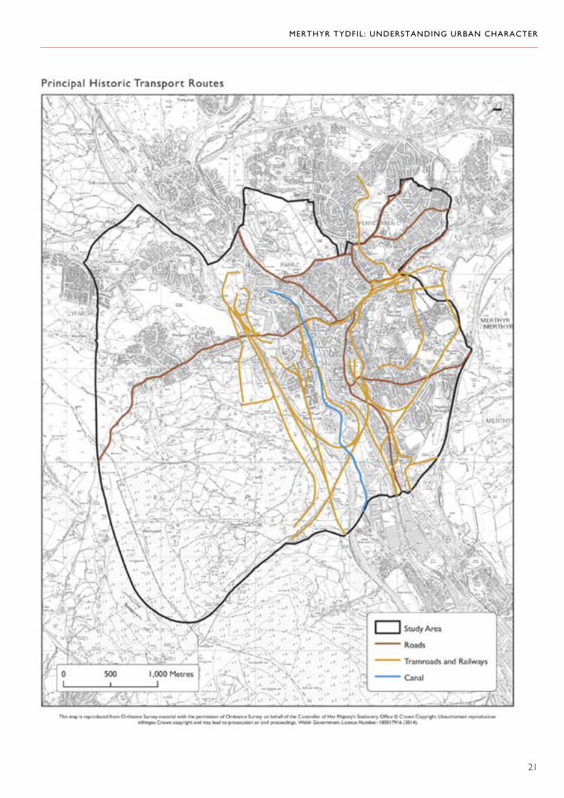
Transport
‘The transmission of the productions of this district is facilitated by the Glamorgan Canal… the Taff Valley Railway to Cardiff and the South Wales to Cardiff, Newport, Swansea and Milford Haven are other efficient modes of conveyance, both for passengers and for the productions of this valuable mineral district.’ 20
Although the early industrialists inherited and used a network of traditional transport routes across the area, all aspects of transport were quickly adapted to the needs of industry, whether by the improvement of inherited routes, or the creation of new ones.
Early roads included the east–west route from Merthyr Tydfil to Abernant by Heolgerrig, and a route through Gellideg, which was later turnpiked as the route between Merthyr Tydfil and Neath. Running north–south, one main route followed the high ground to the east of Merthyr Tydfil between Pontsticill and Llancaiach. From Pencoedivor, a road meandered down into Merthyr Tydfil, corresponding to the line of Galon Uchaf Road, Gwaelodygarth Road and High Street. Twynyrodyn Road was another traditional route connecting this ridgeway to the historical core of settlement around the church. There was also a low-level route on the east side of the Taff between Cefn Coed y Cymmer and Pontygwaith. This route probably continued north to Brecon and south towards Cardiff — Brecon Road and Plymouth Street mark its line, both of which were eventually turnpiked. These old roads formed the framework for settlement and have their own
The Grawen toll house is a legacy of nineteenth-century road improvements. (Crown Copyright: RCAHMW).
distinctive patterns of development. In addition to these through-routes, there was a series of local lanes serving farms and scattered settlement. Some of these have survived in the modern street pattern, for example, Pantyffyn Road (Mountain Hare), Gwaelodygarth Road, Galon Uchaf Road and Gwaunfarren Road, Penydarren.
Considerable improvements to the road network were instigated partly through the patronage of the iron masters. Anthony Bacon built a route from Merthyr Tydfil to Cardiff in 1767. This route followed the valley of the Taff on the east side and probably marked an improvement on the earlier route south from Cefn Coed y Cymmer. It became the Plymouth toll road after the 1771 Turnpike Act.
Other improvements were also put in place. In 1795, the Glamorganshire Navigation Canal Company allowed Jackson’s Bridge, which had been built to carry a tramroad from the ironworks at Dowlais to the canal, to be used to carry a new road across the river. This was probably a new alignment for the Abernant to Merthyr Tydfil road via Heolgerrig, which now continued towards Dowlais. This route intersected the road from Merthyr Tydfil to Brecon, which was turnpiked in 1831 — the Grawen toll house of 1842 is a reminder of this history. The original river crossing was also improved when an iron bridge (a little to the south of the site of the modern bridge close to the foot of Castle Street) was constructed in 1799–1800 to replace a stone-built predecessor destroyed in flooding. Designed by Watkin George, it was paid for by William Crawshay.21 The bridge was dismantled in 1963 with the intention that one day it would be repaired.
Meanwhile, new forms of transport were also introduced to meet the needs of industry. Some of these were entirely local, intended to move materials (including water) from their source to where they were needed. A complicated network of tramroads and tracks threaded the landscape wherever there were significant workings. These local transport routes were an essential part of industrial operations. Their importance, coupled with the distances over which raw materials were sometimes moved, meant that some of these transport routes were ambitious engineering projects that have had a lasting impact on the landscape. The Cyfarthfa
MERTHYR TYDFIL: UNDERSTANDING URBAN CHARACTER
21

MERTHYR TYDFIL: UNDERSTANDING URBAN CHARACTER
22
Right: The raised walkway opposite The Theatre Royal takes the line of a tramroad that ran from Dowlais and Penydarren ironworks to the Glamorganshire Canal (Crown Copyright: RCAHMW).
Below: The memorial commemorating the first time that a steam locomotive ran on rails in 1804 was made from materials recovered from the old Penydarren tramroad (Crown Copyright: RCAHMW).
Canal is an early example: it linked the ironworks with workings to the south and may have given direct access to levels for loading tub boats. It was in operation from the 1770s. Part of its route can still be traced to the west of the A470.
Expanding output from the ironworks made demands for the movement of goods out of the area, which traditional forms of transport could not reasonably meet. This created an incentive for investment in new forms of transport. A scheme for a canal that would link Merthyr Tydfil with Cardiff was devised in 1790: the Glamorganshire Canal was promoted and substantially funded by the four main Merthyr Tydfil iron interests but, in practice, the canal was dominated by Cyfarthfa. The Canal Act permitted tramroad links over a certain distance, and one of the most important of these was the Gurnos tramroad, built by the Cyfarthfa Company to carry limestone from the quarries at Gurnos to the works and to the Glamorganshire Canal. The tramroad was initiated in 1792 and was carried over the Taff, along with the Cyfarthfa leat, on the Pont y Cafnau, a pioneering cast-iron bridge designed by Watkin George.22
The other iron-working companies needed their own routes to connect to the canal, the longest of which were those that linked to the limestone quarries to the north of Merthyr Tydfil. Penydarren and Dowlais requested a link to the canal as soon as the scheme was proposed in 1790. The resulting tramroad ran from Dowlais,

MERTHYR TYDFIL: UNDERSTANDING URBAN CHARACTER
23
roughly following the course of the Morlais brook, to cross the Taff on Jackson’s Bridge. The line is substantially perpetuated in surviving road lines, and the raised pavement opposite The Theatre Royal was specifically constructed for this tramroad.23
The connection to the canal was soon superseded by construction of the Penydarren tramroad, which completed a connection from Morlais quarry to the north, the Penydarren works and the canal at Abercynon. The northern section of this route had probably been established by 1801, and the southern length was completed in 1802. It was instigated as a result of an agreement between the Dowlais, Penydarren and Plymouth ironworks, who were struggling against Cyfarthfa’s hold over the Glamorganshire Canal. Notably, it was on this tramroad that Richard Trevithick’s steam locomotive became the first to run on rails in 1804.
Much of the route survives: the northern section can be traced from the quarry, skirting the east of the Gurnos estate, then passing via Tramroad Lane, Penydarren, to the ironworks site; the southern section is marked by Tramroadside North and South, continuing as a track to the east of Pentrebach Road.
From the 1840s, railways provided transport over longer distances both within the Cyfarthfa landscape and outside it. Thus, the Gethin Railway of around 1850 linked Gethin Colliery
to the south with the Cyfarthfa Ironworks, and Cwm Pit Railway connected Cwm Pit with the ironworks. These railways operated in conjunction with shorter railways and tramroads within the main working areas. Railways also became the principal link to markets and ports and, in time, the Glamorganshire Canal was superseded by railways. The section from Cyfarthfa to Merthyr Tydfil closed in 1865, and it was finally abandoned in 1952 when most of it was filled in, though short lengths survive, for example, adjacent to Chapel Row, Georgetown.
The Taff Vale Railway provided a rail link from Cardiff to Merthyr Tydfil and was intended to relieve congestion on the canal caused in particular by the rise in coal traffic. It reached Merthyr Tydfil via the east bank of the Taff in 1842, and its terminus was between the river and Plymouth Street to the south of the church. The Vale of Neath Railway followed in 1853, opening access to Neath and Swansea via the Aberdare Tunnel. High Street station (the existing station) was the original terminus of this line.24 There was also an important local railway: the Dowlais Railway opened in 1851 following an Act obtained by the Dowlais Company in 1849 to establish a railway between Dowlais and Merthyr Tydfil. It connected to the Taff Vale Railway at Twynyrodyn, and was also linked to the Vale of Neath Railway after 1853. The line of its incline (‘Inky’) from Incline Top remains an important though neglected landscape feature.25
A short length of the Glamorganshire Canal at Chapel Row (Crown Copyright: RCAHMW).

MERTHYR TYDFIL: UNDERSTANDING URBAN CHARACTER
24
The real boom in railway building came in the 1860s, when Merthyr Tydfil was connected to Brecon to the north (the Brecon and Merthyr Railway, completed 1868), and Abergavenny to the east (London and North Western Railway, completed 1879). These railways shared a route from Dowlais, which reached Merthyr Tydfil via the Cefn Coed viaduct. Other routes followed in the 1870s and 1880s, including a new route on the west side of the Taff from Quaker’s Yard to Merthyr Tydfil via Aberfan and Abercanaid (Great Western Railway and Rhymney Railway). The railway network was largely developed for freight, with passenger services an important though secondary function. With the decline of heavy industry, the railways lost their primary industrial purpose and most routes were closed in the 1950s and 1960s, leaving only one rail route — the Merthyr Tydfil to Cardiff service on the original Taff Vale line. It was road transport that supplanted the railways, with the construction of the Heads of the Valleys road in the 1960s, and the A470 from Cardiff (initiated in the 1960s, though taking several decades to complete).26
That Metropolis of Iron Masters: Merthyr Tydfil Becomes a Town27
‘Merthyr is like an American City — the creation of yesterday.’ 28
The vast iron-working enterprises made great demands on the landscape for their successful operation, but they also required a huge labour force. By 1848, Cyfarthfa had 11 furnaces each of which required 400 men including colliers, miners and labourers29; in the 1860s, Dowlais had 20 furnaces and employed about 5,000 men; Plymouth had 10 furnaces and employed 4,000 men. At its peak, Dowlais employed 9,000 men. The population of the town grew at a great pace to sustain the expanding outputs of the main works. It rose from 7,000 in 1801 to 24,000 in 1831, and to 70,000 in 1861. Merthyr Tydfil was the largest town in Wales by this time and remained
The viaduct at Cefn Coed, with the Heads of the Valleys road and A470 in the background. (Crown Copyright: RCAHMW).

MERTHYR TYDFIL: UNDERSTANDING URBAN CHARACTER
25
so until 1871–81, when it was overtaken by Cardiff.30
This huge and growing labour force had to be housed and the need for housing made yet another demand on the landscape. The industries themselves often had the first call on available space, and housing development had to fit in where it could. Much of the earliest growth was informal and opportunistic, expanding out from the early core of settlement around the church, and in dispersed patterns of settlement on the margins of land, which was productive for either agriculture or industry. Examples of early settlement are now rare but Upper Colliers Row is an important survivor. The major ironworks tended to act as the nucleus for settlement too, where the ironmasters provided some housing for key workers. From the early nineteenth century, there were also more formal processes of settlement formation as planned urban developments got under way.
Benjamin Malkin provides a good account of many of these strands of urban development in 1806: ‘The first houses that were built were only very small, simple cottages… most of them built in scattered confusion without any order or plan. As the works increased, more cottages were wanted and erected in the spaces between those that had previously been built, till they became so connected with each other, as to form a certain description of irregular streets. Some streets, it is to be observed, have within these few years been built, and more are building, on a better plan, in straighter lines, and wider,
having decent houses… In some of the early and rudely connected streets, we frequently see the small, miserable houses taken down, and larger and very seemly ones built in their stead… Shopkeepers, innkeepers, forge-men, some of them at least, and in no inconsiderable numbers, are making comfortable fortunes… Great improvements have been made in the past two years. Many new streets have been built, which are sufficiently straight and wide, and more have been laid out. The new houses are in general good, and some of the older streets have been rebuilt on an improved plan. Nearly the whole of the glebe has been laid out in regular streets for building’.31
Merthyr Tydfil in 1811, as shown by J. G. Wood (By permission of Llyfrgell Genedlaethol/National Library of Wales).
The sinuous line of High Street — the backbone of the town centre (Crown Copyright: RCAHMW).

MERTHYR TYDFIL: UNDERSTANDING URBAN CHARACTER
26
Although very little early housing survives, many features of the distinctive pattern of settlement that developed from the end of the eighteenth century are still discernible. Much of the early settlement was essentially linear and followed roads, the canal, or tramroads: ‘Almost the only assemblage of houses in Merthyr deserving of the name of a street — tramroads generally run along the lines of dwellings — is the High Street’.32 Settlement did follow other roads, such as Brecon
Road, Twynyrodyn, and the road to Dowlais — there is early housing on all these routes — and the route of the Penydarren tramroad was particularly important as an axis of settlement. Early departures from this linear pattern have survived at the Quar, around a network of irregular streets, and in Morgantown; both are tightly defined areas of housing, suggesting that they were fitted into existing pockets of land — perhaps small fields.
These houses at Tramroadside North once overlooked the Penydarren tramroad (Crown Copyright: RCAHMW).
Linear settlement at Twynyrodyn (Crown Copyright: RCAHMW).

MERTHYR TYDFIL: UNDERSTANDING URBAN CHARACTER
27
Below: The Quar is a distinctive area of tightly packed streets (Crown Copyright: RCAHMW).
Early lines of housing at Thomastown (Crown Copyright: RCAHMW).

MERTHYR TYDFIL: UNDERSTANDING URBAN CHARACTER
28
The early planned area-based developments described by Malkin in the area of Glebeland to the north of the church have not survived and others, such as Georgetown, have been redeveloped, but Thomastown is an important example of planned development from the middle of the nineteenth century. This more
Thomastown was laid out spaciously in the mid-nineteenth century (Crown Copyright: RCAHMW).
extensive pattern of development, in which whole new streets were laid down, became common practice thereafter. Penydarren represents another good example from the end of the century, when the former park was laid out in a series of planned housing schemes.
Penydarren from the east (Crown Copyright: RCAHMW).
MERTHYR TYDFIL: UNDERSTANDING URBAN CHARACTER
29
Cyfarthfa House was built alongside the ironworks and was the home of the Crawshays before Cyfarthfa Castle was built in 1825. William Pamplin was the artist of this rare view produced between 1791 and 1800 (Photograph reproduced with the kind permission of Cyfarthfa Castle Museum and Art Gallery, Merthyr Tydfil).
Some of the housing associated with Penydarren Ironworks: Church Street, Penydarren (Crown Copyright: RCAHMW).
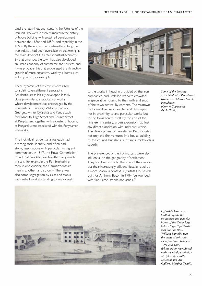
Until the late nineteenth century, the fortunes of the iron industry were closely mirrored in the history of house building, with sustained development between the 1830s and 1850s, and especially in the 1850s. By the end of the nineteenth century, the iron industry had been overtaken by coalmining as the main driver of the area’s industrial economy. By that time too, the town had also developed an urban economy of commerce and services, and it was probably this that encouraged the distinctive growth of more expansive, wealthy suburbs such as Penydarren, for example.
These dynamics of settlement were allied to a distinctive settlement geography. Residential areas initially developed in fairly close proximity to individual ironworks where development was encouraged by the ironmasters — notably Williamstown and Georgetown for Cyfarthfa, and Pentrebach for Plymouth. High Street and Church Street at Penydarren, together with a cluster of housing at Penyard, were associated with the Penydarren Ironworks.
The individual residential areas each had a strong social identity, and often had strong associations with particular immigrant communities. In 1847, the Royal Commission found that ‘workers live together very much in clans, for example the Pembrokeshire men in one quarter, the Carmarthenshire men in another, and so on.’33 There was also some segregation by class and status, with skilled workers tending to live closest
to the works in housing provided by the iron companies, and unskilled workers crowded in speculative housing to the north and south of the town centre. By contrast, Thomastown had a middle-class character and developed not in proximity to any particular works, but to the town centre itself. By the end of the nineteenth century, urban expansion had lost any direct association with individual works. The development of Penydarren Park included not only the first ventures into house building by the council, but also a substantial middle-class suburb.
The preferences of the ironmasters were also influential on the geography of settlement. They too lived close to the sites of their works, but their increasingly affluent lifestyle required a more spacious context. Cyfarthfa House was built for Anthony Bacon in 1784, ‘surrounded with fire, flame, smoke and ashes’.34

MERTHYR TYDFIL: UNDERSTANDING URBAN CHARACTER
30
A romantic depiction of Cyfarthfa Castle by Penry Williams (Photograph reproduced with the kind permission of Cyfarthfa Castle Museum and Art Gallery, Merthyr Tydfil).
It was outclassed by Cyfarthfa Castle, built for the Crawshays in 1825, with a parkland setting still closely connected to the industry that funded it. The lake, for example, was linked to the water supply to the ironworks, which lay within the view from the castle. ‘The south-west embraces, on the foreground, the terrace, park and River Taff, beyond which the great ironworks become conspicuous; these at night offer a truly magnificent scene, resembling the fabled Pandemonium, upon which the eye may gaze with great pleasure… At a distance from the castle, a walk along the river leads to the limestone quarry, where the high projecting rocks, combining with the river and wooded banks, form truly grand and picturesque objects… the style adopted at Cyfarthfa Castle is designed for the situation, standing alone in the midst of rising ground in a bold country’.35 Gwaelod y Garth House, built around 1810, was also briefly the residence of the Crawshays.
Penydarren House, built in 1786, was also set in a substantial park: it was ‘large and elegant, with fine and well-planted gardens, green-houses, hot-houses, and all the accommodations befitting the residence of a wealthy family’.36 The house was close to the ironworks but, unlike Cyfarthfa, did not directly overlook it. Converted to a school, it survived until the 1960s, but was eventually
demolished and the site built over by the housing development at Penydarren Park.
If, in the early years of expansion, Merthyr Tydfil mainly grew up as a series of industrial communities, it was not long before it began to take on the trappings of a town. The early core of settlement around the church and Court House was a nucleus for further development in the industrial period — nineteenth-century maps show a distinctive clustered settlement pattern to the south and east of the church. This haphazard plan suggests development crowding onto plots of land that had already been defined. The sinuous line of High Street running north was also already in existence and, like other early routes, formed the framework for linear development, which here quickly acquired a commercial character. To the north and west of the church, more formal development was also under way in the early years of the nineteenth century. As described by Malkin, this was an early example of town planning and established a regular grid pattern, most of which was lost in twentieth-century redevelopment.
The conscious creation of a town centre took a major step forward in 1838 when the market hall was built, overlooking a ‘spacious square, which, in summer time, is frequently filled with

MERTHYR TYDFIL: UNDERSTANDING URBAN CHARACTER
31
High Street in about 1850 (By permission of Llyfrgell Genedlaethol/National Library of Wales).
exhibitions of all kinds’.37 The square assumed an importance in urban cultural and political life as a major meeting place, and the market itself was an important focal point: ‘the market-house, which is very capacious, may be termed “a bazaar of shops”. The scene from six to ten o’clock every Saturday evening is one of the most extraordinary I have ever witnessed. In this interval what one might suppose the entire labouring population of Merthyr Tydfil passes through its crowded halls… It is not only the
field of supply, but evidently the promenade of the working classes’.38 Other urban institutions followed and their buildings provided other anchor points to demarcate the town centre, for example, the union workhouse of 1853. The fact that there were eventually two railway stations to the east and south of the town centre (The Vale of Neath Railway and the Taff Vale Railway respectively) further consolidated the role of the town centre from the mid-nineteenth century onwards.
Mid-nineteenth-century buildings on Victoria Street, which once overlooked the market hall (Crown Copyright: RCAHMW).

MERTHYR TYDFIL: UNDERSTANDING URBAN CHARACTER
32
Right and below: Flamboyant, turn-of-the-century commercial buildings in the town centre (Crown Copyright: RCAHMW).
But above all, it was commerce that gave a particular character to the town centre. The line of High Street was firmly established as the main axis connecting different residential districts by the mid-nineteenth century, by which time there appears to have been a permanent middle class of tradesmen and shopkeepers. Shops, too, apparently increased as a result of the increasing population. By the end of the century, ‘the commercial quarters of the Merthyr Tydfil district still bear some evidence of belonging to a great centre of population which has been created in a hurry, later years have done much to improve the outward seeming of its leading shops and emporiums’.39 It had acquired a distinctive architectural character, marked by individualism and exuberance. This showed firstly the many hands involved in developing the town centre, where individual buildings or short terraces predominated, and secondly the ambition vested in it. Some of its most distinctive buildings date from the turn of the nineteenth century, at a time when the iron industry was in decline.

MERTHYR TYDFIL: UNDERSTANDING URBAN CHARACTER
33
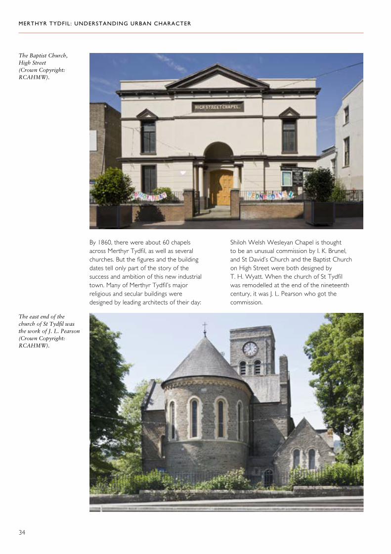
Both the town centre and the satellite residential areas boasted an expanding number of churches and chapels — the town centre also acquired the first purpose-built synagogue in Wales in 1872–75. The building dates help chart not only the physical expansion of settlement, but also key periods in its improvement. The church of St Tydfil, for example, was rebuilt in 1820–21 but substantially remodelled between 1891 and 1901. On High Street, the Baptist Church was built in 1841, Soar was built at Pontmorlais in 1841 (replacing an earlier building of 1823), and St David’s Church was built in 1846–47. In Thomastown, the Welsh Wesleyan Chapel (later the Miners Welfare Hall) was built in 1853. At Twynyrodyn, Seion Welsh Baptist Church was established in 1788, and rebuilt in 1841, and Penuel was built in 1860. On Plymouth Street, Ebenezer Welsh Baptist Chapel was built in 1829–31, whilst at Penydarren, St John’s in Church Street was built in 1858, and the church of St Mary on The Walk in 1893–94.
Below: Ebenezer Welsh Baptist Chapel, Plymouth Street, as depicted by Falcon Hildred in 1981 (Crown Copyright: RCAHMW).
This building in Thomastown was the first synagogue to be built in Wales (Crown Copyright: RCAHMW).
MERTHYR TYDFIL: UNDERSTANDING URBAN CHARACTER
34
By 1860, there were about 60 chapels across Merthyr Tydfil, as well as several churches. But the figures and the building dates tell only part of the story of the success and ambition of this new industrial town. Many of Merthyr Tydfil’s major religious and secular buildings were designed by leading architects of their day:
Shiloh Welsh Wesleyan Chapel is thought to be an unusual commission by I. K. Brunel, and St David’s Church and the Baptist Church on High Street were both designed by T. H. Wyatt. When the church of St Tydfil was remodelled at the end of the nineteenth century, it was J. L. Pearson who got the commission.
The east end of the church of St Tydfil was the work of J. L. Pearson (Crown Copyright: RCAHMW).
The Baptist Church, High Street (Crown Copyright: RCAHMW).
MERTHYR TYDFIL: UNDERSTANDING URBAN CHARACTER
35
Civic Life, Politics and Society
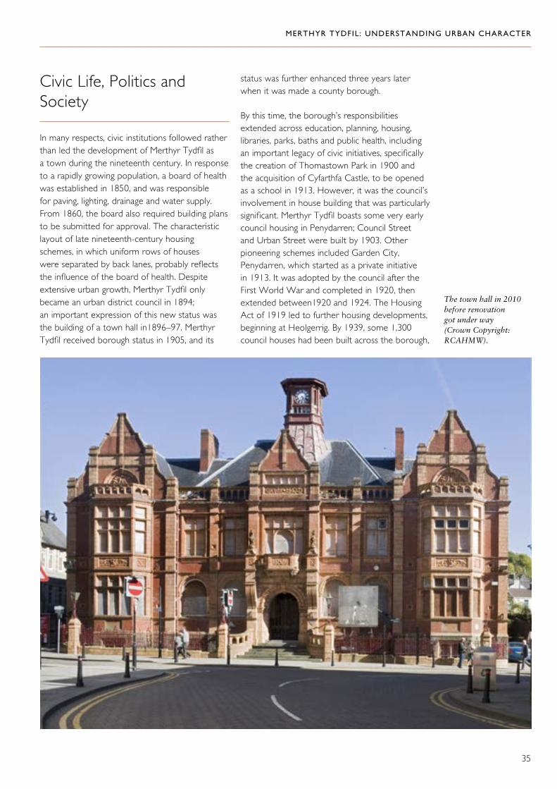
In many respects, civic institutions followed rather than led the development of Merthyr Tydfil as a town during the nineteenth century. In response to a rapidly growing population, a board of health was established in 1850, and was responsible for paving, lighting, drainage and water supply. From 1860, the board also required building plans to be submitted for approval. The characteristic layout of late nineteenth-century housing schemes, in which uniform rows of houses were separated by back lanes, probably reflects the influence of the board of health. Despite extensive urban growth, Merthyr Tydfil only became an urban district council in 1894; an important expression of this new status was the building of a town hall in1896–97. Merthyr Tydfil received borough status in 1905, and its
status was further enhanced three years later when it was made a county borough.
By this time, the borough’s responsibilities extended across education, planning, housing, libraries, parks, baths and public health, including an important legacy of civic initiatives, specifically the creation of Thomastown Park in 1900 and the acquisition of Cyfarthfa Castle, to be opened as a school in 1913. However, it was the council’s involvement in house building that was particularly significant. Merthyr Tydfil boasts some very early council housing in Penydarren; Council Street and Urban Street were built by 1903. Other pioneering schemes included Garden City, Penydarren, which started as a private initiative in 1913. It was adopted by the council after the First World War and completed in 1920, then extended between1920 and 1924. The Housing Act of 1919 led to further housing developments, beginning at Heolgerrig. By 1939, some 1,300 council houses had been built across the borough,
The town hall in 2010 before renovation got under way (Crown Copyright: RCAHMW).

MERTHYR TYDFIL: UNDERSTANDING URBAN CHARACTER
36
mostly in relatively small-scale schemes. Building work was mostly concentrated in the 1920s as council finances suffered during the depression of the 1930s. After the war, renewed investment
and a commitment to redevelopment saw larger-scale building programmes such as the Gurnos estate, and comprehensive redevelopment schemes such as at Caedraw and Georgetown.
Below: Council Street, Penydarren, is an important example of early council housing (Crown Copyright: RCAHMW).
An early view of Thomastown Park (Crown Copyright: RCAHMW).

MERTHYR TYDFIL: UNDERSTANDING URBAN CHARACTER
37
The Gurnos estate from the air (Crown Copyright: RCAHMW).
Gellideg estate, about 1955 (Copyright: The Francis Frith Collection).
Mapped onto the geography of settlement and its key institutions was an urban culture; political radicalism was an important aspect of this. Riots in 1800 and 1816 were significantly overshadowed by the Merthyr Rising in 1831. Partly in reaction to a decision by William Crawshay to lower the wages of his employees, an angry crowd destroyed the Court House and laid siege to the magistrates in The Castle Hotel, at the corner of Castle Street and High Street, Pontmorlais (later the site of the Castle Cinema). In the subsequent confrontation, at
least 20 members of the crowd were shot and killed, and the red flag was raised for the first time.40 The former Court of Requests building in Georgetown is also traditionally associated with the Merthyr Rising, and is said to have been broken into by Dic Penderyn. At the end of that decade, from 1839, Merthyr Tydfil emerged as a main centre for Chartism. Within its highly organized movement, Georgetown was a leading ward, and The Three Horse Shoes public house assumed particular prominence as a popular meeting place.41 The Chartists also used outdoor

MERTHYR TYDFIL: UNDERSTANDING URBAN CHARACTER
38
meeting places, such as the mountainside at Heolgerrig, and periodically occupied the town streets with processions.
However, like the first attempts at an organized unionism, the Chartist movement was short-lived. Merthyr Tydfil’s radical credentials were once again asserted in 1900, when the first socialist Member of Parliament, Keir Hardie, was elected here. Hardie’s candidature was sponsored by the Labour Representation Committee (precursor of the Labour Party) and his victory was announced from the balcony of the town hall.
Loss and Renewal: The Twentieth Century
‘The higgledy-piggledy building which was a feature of the growth of Merthyr in the nineteenth century has left many other problems for the planners, of which one, the narrowness of High Street was alleviated by the A4060 Dowlais Top to Pentrebach road. Nor has their task been made easier by the indiscriminate dumping of waste from furnace and colliery which was allowed to go on unchecked until recent years. The black spots are disappearing one by one, and in their building programme the Council
are providing homes for the people a little farther away from the congested areas.’ 42
In the early years of the twentieth century, the town was still expanding and some ambitious new buildings were under construction, both for commercial and civic purposes: for example, Milbourne Chambers, the YMCA building, the Masonic Temple, the former post office on John Street of 1903–05, and Lloyds Bank, 1922–23. The council was also at the forefront of house building — Council Street and Urban Street in Penydarren, built by 1903, were the first in a programme of municipal housing which had provided 1,351 houses across the borough by the Second World War.43
But, by the 1920s, the grim realities of economic collapse had asserted themselves and the population fell from 80,000 to 63,000 between 1921 and 1937.44 By 1932, unemployment was at 62.3 per cent, and the council paid out more in unemployment benefit in that year than the cost of all its services in 1919. By 1938, the value of all the property in the borough was only half the cost of unemployment benefit.45 Against this background, there simply were not the local resources to invest in renewal. In 1939, a parliamentary report
The militia trying to restore order during the 1816 riots, as shown by Penry Williams (Photograph reproduced with the kind permission of Cyfarthfa Castle Museum and Art Gallery, Merthyr Tydfil).

MERTHYR TYDFIL: UNDERSTANDING URBAN CHARACTER
39
even recommended that Merthyr Tydfil be completely abandoned, the remainder of its people removed to the coast or to the Usk Valley, and a reservoir made on the site of the town. After the Second World War, however, an interventionist government helped create a climate of renewal. Encouraged by the Distribution of Industries Act, new businesses
Some fine early twentieth-century buildings: Milbourne Chambers (top left), the former post office (top right) and the YMCA (left) (Crown Copyright: RCAHMW).
were established, such as Hoover (1948) and Thorn Electrical Industries (1951). Other important public projects included the College of Further Education of 1950–52. Resources for slum clearance and redevelopment were also made available, and there was considerable investment in new housing. Under slum clearance programmes in the 1960s and 1970s, some 280
MERTHYR TYDFIL: UNDERSTANDING URBAN CHARACTER
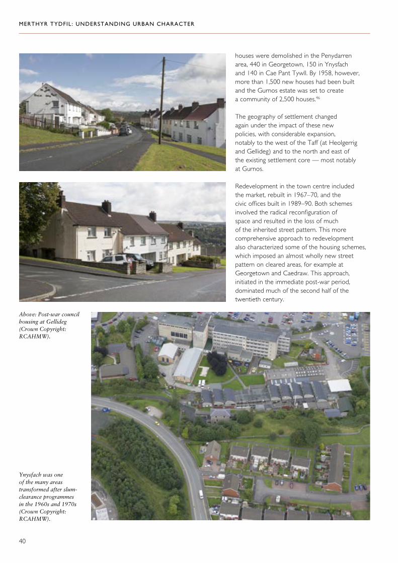
40
houses were demolished in the Penydarren area, 440 in Georgetown, 150 in Ynysfach and 140 in Cae Pant Tywll. By 1958, however, more than 1,500 new houses had been built and the Gurnos estate was set to create a community of 2,500 houses.46
The geography of settlement changed again under the impact of these new policies, with considerable expansion, notably to the west of the Taff (at Heolgerrig and Gellideg) and to the north and east of the existing settlement core — most notably at Gurnos.
Redevelopment in the town centre included the market, rebuilt in 1967–70, and the civic offices built in 1989–90. Both schemes involved the radical reconfiguration of space and resulted in the loss of much of the inherited street pattern. This more comprehensive approach to redevelopment also characterized some of the housing schemes, which imposed an almost wholly new street pattern on cleared areas, for example at Georgetown and Caedraw. This approach, initiated in the immediate post-war period, dominated much of the second half of the twentieth century.
Ynysfach was one of the many areas transformed after slum-clearance programmes in the 1960s and 1970s (Crown Copyright: RCAHMW).
Above: Post-war council housing at Gellideg (Crown Copyright: RCAHMW).

MERTHYR TYDFIL: UNDERSTANDING URBAN CHARACTER
41
‘Merthyr Tydfil… lies between rough bleak mountains besides heaps of cinders which rise to an immense height.’ 47
Merthyr Tydfil enjoys a striking, natural situation in the steep-sided valley of the river Taff, close to the source of the many raw materials that sustained its industrial economy and society. Out of the natural topography, an industrial landscape was created and the natural landforms modified by extraction and tipping. The town grew in the areas between land valued for its natural resources, and its growth was constrained by them. Housing had to be accommodated around the needs of industry: the works, their mines and quarries; tips and transport systems had first call on the land, and residential areas were crowded where they could fit.
The Landscape of Industry
The industrial development of Merthyr Tydfil was dominated by four major iron-working concerns, each of which had its own discrete landholding. On these holdings, many distinct activities took place: mining for coal, ironstone, and limestone, the processing of raw materials (such as calcining or coking) and the dumping of waste. The production of cast and wrought iron in the ironworks at Cyfarthfa and Ynysfach, Penydarren, Plymouth, Pentrebach and Dyffryn, Dowlais and Ivor was the focal point of all this activity. In addition, all the raw materials needed to be brought to the ironworks and the finished products needed to be transported away. The landscape was therefore threaded with an intricate mesh of transport routes to and from
Historical Topography Merthyr Tydfil in 1850 (By permission of Llyfrgell Genedlaethol/National Library of Wales).

MERTHYR TYDFIL: UNDERSTANDING URBAN CHARACTER
42
the ironworks. Extraction, processing, waste disposal, and transport were the primary shapers of the landscape in Merthyr Tydfil.
In many areas, the evidence of extraction, dumping and processing has been obliterated by redevelopment, and the core areas of ironworks have been either virtually lost (Penydarren) or marginalized (Cyfarthfa, Ynysfach, Plymouth). Many historical transport routes have also been built over or left to decay. However, in many areas, some sense of the interconnection of activities can still be gained. This is particularly true of the landscape associated with Cyfarthfa west of the Taff, which is still rich in the evidence of industry and where traces of its transport systems survive. However, the modern road system, retail and residential developments have disrupted historical connectivity to the core sites of the ironworks at Cyfarthfa and Ynysfach, with their impressive surviving structures. Similarly, from the north and east, an interconnected landscape can still be traced, following the leat from the Taff Fechan and the tramroad from the quarries at Gurnos to the ironworks site via Pont y Cafnau, taking in the limekilns
below Cefn Bridge. Cyfarthfa Castle and Park are an integral part of this connected industrial landscape, designed to overlook the ironworks, and intended to have visual and actual links to the wider industrial resources of the estate, including the use of the lake as part of the water supply to the works. In the vicinity of the castle and park, not only does early industrial housing survive, but also one of the estate farms.
In no other area are the historical connections between components of the industrial landscape so clear. Elsewhere, transport routes and the settlement pattern itself provide the strongest links to the original rationale of development.
Settlement Patterns
The original settlement was limited to the east bank of the Taff and appears to have been clustered in the vicinity of the church. Here a tight, but rather haphazard, development pattern in the nineteenth century may have reflected an earlier irregular layout. Expansion to the west was
Cyfarthfa Castle in its parkland setting — the lake was not merely ornamental but was also part of the water supply for the ironworks (Crown Copyright: RCAHMW).

MERTHYR TYDFIL: UNDERSTANDING URBAN CHARACTER
43
Early housing close to the works at Cyfarthfa and Ynysfach — Williamstown (left) and Chapel Row (below) (Crown Copyright: RCAHMW).
The location of the ironworks exerted a direct influence on the location of settlement. Williamstown and Georgetown were developed in close proximity to the Cyfarthfa and Ynysfach works. At Penydarren, too, there were some haphazard developments that formed the historical nucleus of the settlement at Penyard, but there was also a sizeable linear settlement opposite the works. There has been some redevelopment, but the remnants of this settlement survive at Church Street.
limited by the demands of Cyfarthfa Ironworks and Ynysfach, which relied on this landscape for raw materials and for tipping. Similarly, to the south and east, the primary demand on the landscape was to supply the Dowlais, Plymouth and Penydarren ironworks. As the location of extraction shifted around the area over time, some previously worked areas were eventually built over — by 1848, Clarke observed ‘many of the tips have been built on’ — he also commended the view of the town commanded by the tips at the confluence of the Morlais and the Taff.48

MERTHYR TYDFIL: UNDERSTANDING URBAN CHARACTER
44
The framework presented by transport routes of different kinds was as important as the location of the ironworks for the shaping of settlement. Some of the earliest surviving housing lies along roads, tramroads or the canal, and the town centre itself is unusual for its strong linear development. Planned development with a laid-out street pattern on larger plots of land began in the early nineteenth
century, consolidating the separate identity of different settlements, notably Thomastown and Georgetown to begin with followed by Penydarren. In the twentieth century new developments also followed planning conventions, whilst redevelopment has tended to efface both earlier haphazard patterns and the more regular planned settlements (Caedraw and Georgetown, for example).
Penydarren is a good example of a planned settlement.
Linear settlement at Church Street (right), Penydarren; Brecon Road (below right) and along Tramroadside North (below left) (Crown Copyright: RCAHMW).

MERTHYR TYDFIL: UNDERSTANDING URBAN CHARACTER
45
The social geography of settlement was also of defining importance. As the town centre developed with commercial buildings and civic institutions, the long thread of High Street was dominated by shops and offices, with manufacturing and other activities taking place in yards behind the buildings. Much of this ‘back-land’ development has gone, but Old Mill Lane and the rear of buildings on the south side of Pontmorlais West and Pontmorlais Circus are good surviving examples. The small lanes and alleys that run between the main frontages, particularly along High Street, Pontmorlais, are an important legacy of this development pattern. High Street linked individual residential districts, each of which acquired a character of its own. Some of these were poor residential areas — China to the north (‘the district called China consists totally of thieves’ in the 1840s49) and Caedraw to the south.
By contrast, Thomastown was developed as a higher-status suburb with a unified architectural character. Although Penydarren exhibits considerable variety, the middle-class houses of Merthyr Tydfil are mainly concentrated here.50 Like Cyfarthfa Park, Penydarren Park had previously been barred from development for entirely social reasons because it was the private family estate of a major ironmaster. The sale of Penydarren Park for development in the late nineteenth century created the opportunity for new suburban expansion on an ambitious scale after about 1880.
High Street (Crown Copyright: RCAHMW).
Thomastown was developed as a high-status suburb in the mid-nineteenth century (Crown Copyright: RCAHMW).
Penydarren Park was developed with high-quality suburban housing in the late nineteenth century: these houses on Gwaelodygarth Road are good examples (Crown Copyright: RCAHMW).

MERTHYR TYDFIL: UNDERSTANDING URBAN CHARACTER
46
The Character of Building
‘One vast assemblage of churches, chapels, houses and hamlets, all blended into one vast extensive scene.’ 51
Building Materials
The information about building stone in Merthyr Tydfil is based on a report prepared for this study by Jana Horák and John Davies, Department of Geology, Amgueddfa Cymru — National Museum Wales.
Snecked Pennant Sandstone in housing on Stuart Street (top) and Tudor Terrace (middle). Coursed Pennant Sandstone with brick on Gwaelodygarth Road (bottom) (Crown Copyright: RCAHMW).
‘The houses are built of a peculiar grey sandstone, raised in abundance by the patchers who quarry for the nodules of iron ore... this stone costs little more than the cost of carting.’ 52
The geology that provided the raw materials for Merthyr Tydfil’s industrial development also contributed local building materials. The Coal Measures were the source of two building stones — Pennant Sandstone and the Farewell Rock — whilst three other building stones, outcropping at a greater distance from the town, were occasionally also used for building: Basal Grit or Twrch Sandstone, Carboniferous Limestone and Devonian Old Red Sandstone. Some building stone was also imported from more distant sources, notably Bath Stone, used mainly as dressings in civic buildings, churches and some higher-status housing.
Pennant Sandstone
Pennant Sandstone weathers from a grey-blue colour to rusty brown as the iron content oxidizes. It is by far the commonest building stone in the area and was in widespread use as rubble in walling intended to be limewashed or rendered. Where it is exposed, it is typically used as dressed blocks, either as regular courses or random coursing with jumpers. The courses vary from quite thin, for example about 4 inches (10cm), to more substantial blocks. The dimensions are determined by the original thickness of bedding in the sandstone. The sandstone is often combined with other materials as dressings. Bath Stone is most common in civic and some higher-status housing, but red brick and Ruabon terracotta were also used. Examples include St Tydfil’s Church and St David’s Church (High Street), St Mary’s Church (The Walk) (Pennant and Bath Stone) and Old Town Hall (Pennant with red Cattybrook brick and terracotta). Red and yellow brick are particularly common dressing materials, particularly in terraced housing, for example, in Gwaelodygarth Road, Penydarren, and Dynevor Street, where the yellow brick may have been intended to emulate Bath Stone. It was also used in some higher-status housing, such as along The Walk. Pennant Sandstone was sometimes used for dressings as well as the main walling material.

MERTHYR TYDFIL: UNDERSTANDING URBAN CHARACTER
47
Farewell Rock
The Farewell Rock is a quartz-rich sandstone distinguishable from Pennant Sandstone by its lighter cream colour and distinctive orange weathering. It has a much more limited outcrop and its use in this area is limited to a single building — the Newlife Church, Swansea Road, Gellideg. This isolated use of Farewell Rock may have been influenced by the connections of Robert T. Crawshay Esq., who donated both the land and the stone for its construction in 1860.
Basal Grit
Although Pennant Sandstone is the building stone that dominates Merthyr Tydfil, some other locally occurring stones were used from time to time. Basal Grit is a quartz-rich sandstone that was primarily extracted as a source of silica and as a refractory material. It was used for terraced housing in Graig Terrace and Victoria Street, Dowlais; also for St John’s Church (recently demolished) and the adjacent vicarage, and other buildings in Church Street, Penydarren. There is an isolated example on Fothergill Street, Penyard. In all instances, the dressings are of brick. The distribution of Basal Grit as a building stone is not linked to the bedrock geology and is therefore attributed to the choice, for whatever reason or connection, of the builders/developers.
Carboniferous Limestone
Carboniferous Limestone is poorly represented in the survey area. The most prominent example of its use is at Cyfartha Castle. Here, large blocks of grey micritic limestone have been used for the supporting wall to the terrace on the west side of the building and also for the infill building in the courtyard on the north side of the castle. Many of the limestones of the north crop of the South Wales Coalfield are irregularly jointed and are also hard and brittle. Consequently, they do not lend themselves easily to dressing.
Pennant Sandstone was the main building material used at Cyfarthfa Castle (above), but Carboniferous Limestone was also used here. The castle is shown gleaming white in this picture of about 1840 (By permission of Llyfrgell Genedlaethol/National Library of Wales; Crown Copyright: RCAHMW).

MERTHYR TYDFIL: UNDERSTANDING URBAN CHARACTER
48
Old Red Sandstone
Old Red Sandstone was used as a building stone on a very limited basis. Recorded examples are all outside the study area: in Dowlais, along Pant Road, Victoria Street and Pant Terrace, where homogenous dull red sandstones have been used for walling, windows and dressings, and door openings. In many of these properties the window dressings are now replaced with concrete. This suggests that sandstone was not sufficiently durable to weathering when face-bedded.
Although local building materials dominated construction until the end of the nineteenth century, the precise way in which they were used changed with fashion. Earlier buildings were probably either limewashed or rendered. Scribed render was probably the principal finish applied to rubble walls in Thomastown in the mid-nineteenth century, for example. From the end of the nineteenth century, the fashion for exposed stone started to take hold, which required more care in coursing and dressing, and gave greater emphasis to the use of other materials for dressing.
From the mid-nineteenth century, building materials could be transported to the area relatively easily by rail, and this is reflected in the use of Bath Stone for dressings. For example, Christ Church, Aberdare Road, Heolgerrig, was completed in 1857 and St John’s Church, Penydarren in 1858, shortly after the opening of the railway from Cardiff. The railways also allowed brick to be used more extensively and it slowly replaced stone as a building material. For example, part of St Tydfil’s Hospital (1896–1900), originally built as the workhouse infirmary, was built from yellow brick, and by the early twentieth century, the use of brick was widespread in new building. There are some striking examples of its use in the
town centre around the turn of the nineteenth century. By 1932, there were no building-stone quarries operating in the Merthyr Tydfil area: the Carnegie Library (1935–36) was constructed from ashlar-like blocks of concrete.
The Chronology of Building
Very little of the early industrial housing has survived in Merthyr Tydfil. Although there are significant survivals from the 1830s, most of the historical housing stock dates from later periods. House building followed economic cycles and there was a boom in the 1840s. In 1846, The Cardiff and Merthyr Guardian noted that ‘the rage for building in Merthyr… continues with unabated vigour… sly little bits of ground concealed from public view by a sombre wall and accessible from the public streets only by narrow alleys are introduced to notice and forthwith become the sites of cottages’.53 Little of this period survived twentieth-century clearance programmes, but, from the 1850s, there is a more consistent survival rate from several distinct phases of building activity. The most notable large-scale developments are at Thomastown, built between 1852 and 1856, and at Penydarren after about 1880, but there are examples throughout the area of small-scale building projects from most decades from the 1850s through to the first two decades of the twentieth century. In the late nineteenth century and early years of the twentieth century, there was also considerable commercial and civic building, which has made a major contribution to the character of the town centre.
The chronology of building in the twentieth century also closely followed the economic fortunes of the town, with very little activity between the 1920s and 1950s, and a long redevelopment programme thereafter.
Render became a popular finish in the mid-nineteenth century: its scribed treatment is clearly visible in the first house in this photograph of Alma Street, Thomastown (Crown Copyright: RCAHMW).
Far right: Striking use of brick on Gwaelodygarth Road (Crown Copyright: RCAHMW).

MERTHYR TYDFIL: UNDERSTANDING URBAN CHARACTER
49
Building Styles
Throughout the area there are many fine individual buildings, including proud churches and chapels. Their style and quality of materials and finish are testimony to the aspirations and resources of their builders, and chart the rising fortunes of the town throughout the nineteenth century. These landmark buildings punctuate the townscape, which is otherwise dominated by domestic and commercial building.
Domestic Building
Although there may once have been a tradition of informal building, surviving developments tend to suggest an organized process. The earliest surviving housing is from the early nineteenth century and is in short terraced rows, most of which are conceived as a single development. Within these rows, individual houses are mainly double-fronted and one room deep except where additional accommodation was provided under a catslide roof. This is a plan-type that was probably derived from rural traditions of building. The rural origins of this house type are displayed most clearly at Upper Colliers Row, where there were stone stairs alongside the chimneys, and the roofs were originally covered in stone slabs.
In 1850, the double-fronted houses were considered to be the best, occupied by skilled artisans, and described by the Morning Chronicle in 1850 as ‘of two storeys, have four small sash windows, two above and one each side of the door’.54 In the decades that followed, this house type gave way to one that was better adapted to the circumstances of urban building, in which space was at a premium. Double-depth houses, with a definite back as well as a front, supplanted the long double-fronted single-aspect house. By this time, more imaginative interpretations of the terraced house were in evidence: in Thomastown, long terraces were composed as single units, with central or end-of-row emphasis.
There were some important examples of early experimental house types, including back-to-backs and up-and-over houses, but although some of these have been recorded, none has survived.
Early double-fronted cottages at David Street (top) and Lower Thomas Street (left) (Crown Copyright: RCAHMW).
Below: Planned development: Stuart Street (Crown Copyright: RCAHMW).

MERTHYR TYDFIL: UNDERSTANDING URBAN CHARACTER
50
Larger terraced houses with small front gardens on Park Terrace (right) and Norman Terrace (below) (Crown Copyright: RCAHMW).
Formal treatment to the corner building on Upper Thomas Street (Crown Copyright: RCAHMW).
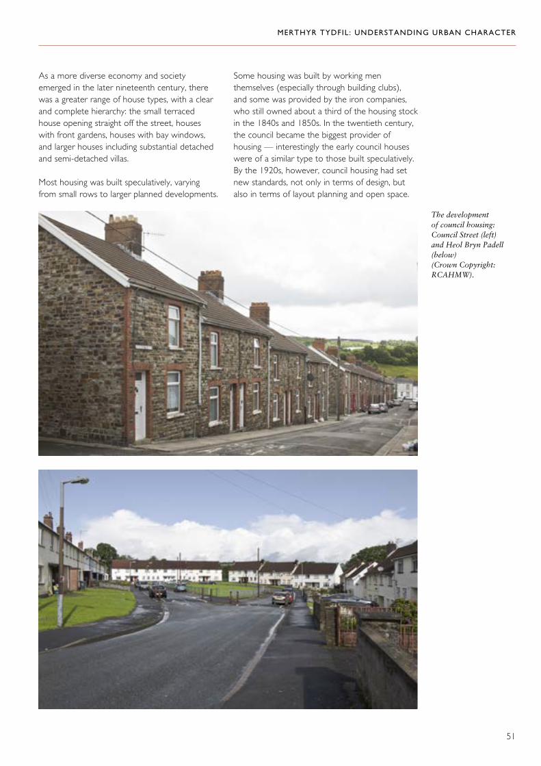
MERTHYR TYDFIL: UNDERSTANDING URBAN CHARACTER
51
As a more diverse economy and society emerged in the later nineteenth century, there was a greater range of house types, with a clear and complete hierarchy: the small terraced house opening straight off the street, houses with front gardens, houses with bay windows, and larger houses including substantial detached and semi-detached villas.
Most housing was built speculatively, varying from small rows to larger planned developments.
Some housing was built by working men themselves (especially through building clubs), and some was provided by the iron companies, who still owned about a third of the housing stock in the 1840s and 1850s. In the twentieth century, the council became the biggest provider of housing — interestingly the early council houses were of a similar type to those built speculatively. By the 1920s, however, council housing had set new standards, not only in terms of design, but also in terms of layout planning and open space.
The development of council housing: Council Street (left) and Heol Bryn Padell (below) (Crown Copyright: RCAHMW).

MERTHYR TYDFIL: UNDERSTANDING URBAN CHARACTER
52
Some of the variety of commercial buildings in the town centre (Crown Copyright: RCAHMW).
Commercial Building
Specific commercial architecture is concentrated along the length of High Street from the church of St Tydfil to Pontmorlais, including the short streets leading off it: Glebeland Street, Victoria Street and John Street. Notable themes include larger buildings, many of three storeys, and several that have a substantial footprint; signature buildings, such as the eye-catching banks and stylish individual shops; big block developments such as a terraced row or the impressive block of Milbourne Chambers. There is also considerable variety in materials and styles, and the exuberant use of decorative detail. Until the later nineteenth century, commercial architecture was mainly a restrained classical style using render with simple detailing, exemplified in the remnants of the formal development associated with the market square along Victoria Street, as well as some properties on High Street. In the later nineteenth century, greater stylistic freedom was matched by a greater variety of materials and finish, including imported stone, brick and terracotta, and even timber-framing. Exotic influences from Italy and Flanders, such as the gable-fronted terrace on High Street, Pontmorlais, and elsewhere were perhaps used as a conscious echo of other great European towns.

MERTHYR TYDFIL: UNDERSTANDING URBAN CHARACTER
53
Historical Associations
There are important historical associations attached to particular buildings, including the town hall, Vulcan House (the site of a Chartist printing press in the 1840s), The Three Horse Shoes Inn (a Chartist meeting place), and the former Court of Requests in Georgetown (said to have been broken into by Dic Penderyn). The former labour exchange (originally the YMCA building) is also said to have been the destination for a march of 10,000 protesters from Dowlais in 1938.
There are also important historical associations with the streets and spaces of the town.
There was a tradition of the working classes taking an informal promenade on Saturday and Monday nights, from eight until ten o’clock, but there were also more formal marches and processions. A favoured route for these was along High Street, Pontmorlais, because it was the main link between the industry of Penydarren and Dowlais, and the centre of the town. In 1910, Col. David Rees Lewis VD had the largest ever military funeral in Wales; the procession was over a mile long from Penydarren and through Pontmorlais. This was also the route taken by various circuses; there is an old film taken around the 1940s, which shows elephants marching along the street.55 On a more serious note, in 1938, the road down the Morlais Valley was the route taken by the march to the labour exchange.
Examples of the variety of commercial buildings in the town centre (Crown Copyright: RCAHMW).

MERTHYR TYDFIL: UNDERSTANDING URBAN CHARACTER
54
Character Areas
1. Town Centre: High Street and Pontmorlais
‘Buildings of reckless and rollicking eccentricity.’ 56
Historical Background
There was probably a small core of settlement from the medieval period focussed around the church. By the sixteenth century, if not earlier, this included at least one substantial house.
By the late eighteenth century, industrialization was stimulating the rapid expansion of settlement in this area, initially rather haphazardly around an inherited plot pattern of irregular units of land, and strung out along the length of High Street. This had given way to a more ordered development process in the early nineteenth century, with the development in phases of Glebeland (to the west of High Street, between Swan Street and Castle Street) as a coherent area with wider streets — Wellington Street (originally Clive Street), Victoria Street (originally Thomas Street) and Graham Street.
Extract from the 1875 first edition Ordnance Survey map showing Merthyr Tydfil town centre.

MERTHYR TYDFIL: UNDERSTANDING URBAN CHARACTER
55
Remnants of the ‘charming sedateness’ of mid-nineteenth- century Victoria Street (Crown Copyright: RCAHMW).
This was underway by 1804 and was effectively completed by the establishment of the market in 1838, the centrepiece of a fine urban square. Victoria Street formed a part of this: ‘having on one side a long row of stucco-fronted shops exemplifying a charming sedateness which still reflects the regency influence’. 57
Perhaps because of different patterns of ownership, development to the north of Castle Street (between 1836 and 1875) and to the south-east of the church was much more crowded.
Development along High Street probably began as residential but it soon acquired a commercial role as the thread linking different residential areas. This change in function brought with it extensive rebuilding in several distinct phases. Few, if any, buildings from the early nineteenth century survive along its line, but there are some from the middle of the century, and many more from the late
nineteenth and early twentieth centuries. There was also a shift towards pure retail. In the process many back yards were built over and minor industrial uses lost. A legacy of earlier use remains, for example, at Mill Lane and in the alleys that once gave direct access to working rear yards.
By the end of the nineteenth century, High Street had consolidated its role as an important civic, religious and cultural focus in the town. It had a concentration of chapels and churches, as well as the town hall, which was built in 1896 after Merthyr Tydfil became an urban district council.
Historical transport has had a strong influence on settlement here. The line of High Street is an early route and, immediately to its east, the line of the Penydarren tramroad (1804) marks a real boundary between the town centre and Thomastown beyond. From the 1840s, the railway lines and station created an even stronger boundary to the east.
Only some of this street pattern and development pattern has survived redevelopment in the twentieth century: much of Glebeland was refashioned, Caedraw and the area to the north of Castle Street were comprehensively redeveloped (the latter between 1959 and 1965), and the area to the south-east of the church was reshaped in successive road schemes.
The line of the Penydarren tramroad ran immediately behind High Street, Pontmorlais (Crown Copyright: RCAHMW).

MERTHYR TYDFIL: UNDERSTANDING URBAN CHARACTER
56
The Character of Building
Redevelopment in the twentieth century removed a substantial part of the historical street pattern, but High Street, Swan Street, Glebeland Street and Castle Street are important survivors that still anchor the area to its past; Caedraw Road also represents the historical line of Picton Street.
Despite redevelopment, the area retains a rich architectural legacy from Merthyr Tydfil’s development in the nineteenth and twentieth
centuries. Little has survived visibly from an earlier period (although The Crown Inn is dated 1785), but there is a clear legacy from the mid-nineteenth century, including several blocks on High Street, The Wyndham Arms on Glebeland Street, and the partial survival of Victoria Street. The strongest contribution to the architectural character of the town comes from substantial investment in the late nineteenth and early twentieth centuries. There are excellent examples of buildings from around 1900 along the length of High Street, on Glebeland Street and John Street.
Redevelopment has isolated the church from its original context in the heart of the town (Crown Copyright: RCAHMW).
Above: A photomontage of High Street, Pontmorlais (Crown Copyright RCAHMW).

MERTHYR TYDFIL: UNDERSTANDING URBAN CHARACTER
57
Left: The Wyndham Arms is a good example of a mid-nineteenth-century urban building (Crown Copyright: RCAHMW).
The status of this bank building is demonstrated by the use of expensive imported materials (Crown Copyright: RCAHMW).
Above: The Crown Inn is one of the earliest surviving buildings on High Street (Crown Copyright: RCAHMW).
The variety of periods of building is matched by the considerable variety in materials. Until the late nineteenth century, render predominated with a simple vocabulary of detail drawing on classical traditions. It was supplanted in architectural fashion by exposed stone, brick and terracotta, often used in combination and in a variety of styles. Imported stone was also favoured for some high-status commercial buildings such as Barclays Bank of 1901–02, which uses black granite and white Portland Stone.
The town centre is characterized by a lively pattern of development, mostly in short rows

MERTHYR TYDFIL: UNDERSTANDING URBAN CHARACTER
58
or substantial single buildings. Commercial building became more assertive as the century wore on: High Street boasts some particularly flamboyant bank buildings as well as shops. Milbourne Chambers is a good example of bold commercial building on a large scale, but even the former
Temperance Hall on John Street (1852, but rebuilt 1888) has a strongly detailed frontage. Despite a vigorous individualism in style, there is also a controlled townscape quality to development here, with consistent building lines and heights, and the architectural treatment of corners.
Right: Highly individual buildings give vibrancy to High Street (Crown Copyright: RCAHMW).
Far right: The former Temperance Hall on John Street, built in 1852 and entirely rebuilt in 1888 (Crown Copyright: RCAHMW).
A corner has been given architectural treatment in this mid-nineteenth-century commercial building, which is also a good example of the fashion for render in that period (Crown Copyright: RCAHMW).
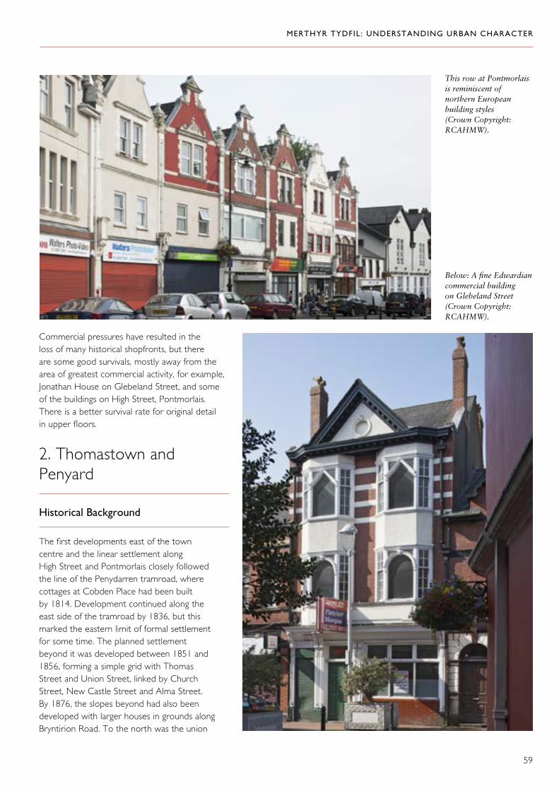
MERTHYR TYDFIL: UNDERSTANDING URBAN CHARACTER
59
This row at Pontmorlais is reminiscent of northern European building styles (Crown Copyright: RCAHMW).
Below: A fine Edwardian commercial building on Glebeland Street (Crown Copyright: RCAHMW).
Commercial pressures have resulted in the loss of many historical shopfronts, but there are some good survivals, mostly away from the area of greatest commercial activity, for example, Jonathan House on Glebeland Street, and some of the buildings on High Street, Pontmorlais. There is a better survival rate for original detail in upper floors.
2. Thomastown and Penyard
Historical Background
The first developments east of the town centre and the linear settlement along High Street and Pontmorlais closely followed the line of the Penydarren tramroad, where cottages at Cobden Place had been built by 1814. Development continued along the east side of the tramroad by 1836, but this marked the eastern limit of formal settlement for some time. The planned settlement beyond it was developed between 1851 and 1856, forming a simple grid with Thomas Street and Union Street, linked by Church Street, New Castle Street and Alma Street. By 1876, the slopes beyond had also been developed with larger houses in grounds along Bryntirion Road. To the north was the union

MERTHYR TYDFIL: UNDERSTANDING URBAN CHARACTER
60
workhouse, begun in 1853 and extended in 1870, and the infirmary 1896–1900.
The area to the east of Bryntirion Road was not developed until the twentieth century, and development was shaped by pre-existing agricultural and industrial land use, existing roads and tramroads. This area had once been the agricultural holdings of Cae Mari Dwn and the Court House, and an extractive landscape associated with the Penydarren Ironworks (from the early nineteenth century until 1859 when the works closed). This landscape included quarries and tips along Queens Road, and ironstone and coal workings further east, linked by tramroad with the ironworks
at Penydarren. Development here was largely social housing, combined with leisure and educational facilities. Between 1910 and 1915, The Parade, Argyle Street and Summerhill Place were developed (the latter following a former field boundary), together with Woodland Terrace and Kingsley Terrace, St Tydfil’s Avenue and Queens Road. Thomastown Park was created in 1900 on the site of a former quarry.
Penyard developed between 1898 and1915 from its origins as isolated industrial cottage rows associated with the Penydarren Ironworks, the site of which lay immediately to the north. None of the early housing survives and the ironworks site has been largely redeveloped also.
New Castle Street (top) and Union Terrace in Union Street (below), part of the planned settlement of Thomastown (Crown Copyright: RCAHMW).

MERTHYR TYDFIL: UNDERSTANDING URBAN CHARACTER
61
The Character of Building
Some of the earliest housing is represented by the low terraced rows along Tramroadside, where small single- and double-fronted cottages are curved to follow the line of the Penydarren tramroad. Most of these are now rendered, but were probably originally limewashed. They are built almost back-to-back with houses on Lower Thomas Street, which are also double fronted and also probably date from the early nineteenth century.
Early cottages on Lower Thomas Street have a vernacular character that contrasts with the more sophisticated appearance of the mid-nineteenth-century terraces (Crown Copyright: RCAHMW).
The main development at Thomastown is a formal layout of terraced houses in long rows with a unified composition, sometimes given emphatic symmetry by the use of pedimented central and end gables, or given a strongly rhythmical treatment by the use of continuous string courses, emphasized by balanced end-gabled blocks. The combined chapel and housing on New Castle Street is a particularly good example of unified design.

MERTHYR TYDFIL: UNDERSTANDING URBAN CHARACTER
62
The classical detail and rendered finish of the housing here are typical of the mid-nineteenth century. Overall unity of composition nevertheless allowed for varied detail and there is more than one design of door-case. There has been extensive renewal of detail and finish, but some examples of lined-out render survive. The larger villas in the east — The Rectory, Sunny Bank Villa, Bryn-heulog, and Springfield — are all generally in a classical style, with render and hipped roofs. There is an important series of significant religious and public buildings in the area, including the synagogue (1872–75), Shiloh Welsh Wesleyan Chapel, the Unitarian Chapel on Lower Thomas Street and the former union workhouse and infirmary.
Smooth rendered finish and simple classical detail on houses on Lower and Upper Thomas Street (Crown Copyright: RCAHMW).
The Unitarian Chapel on Lower Thomas Street is one of several fine religious buildings in the area (Crown Copyright: RCAHMW).
Bold classical detail on New Castle Street (Crown Copyright: RCAHMW).
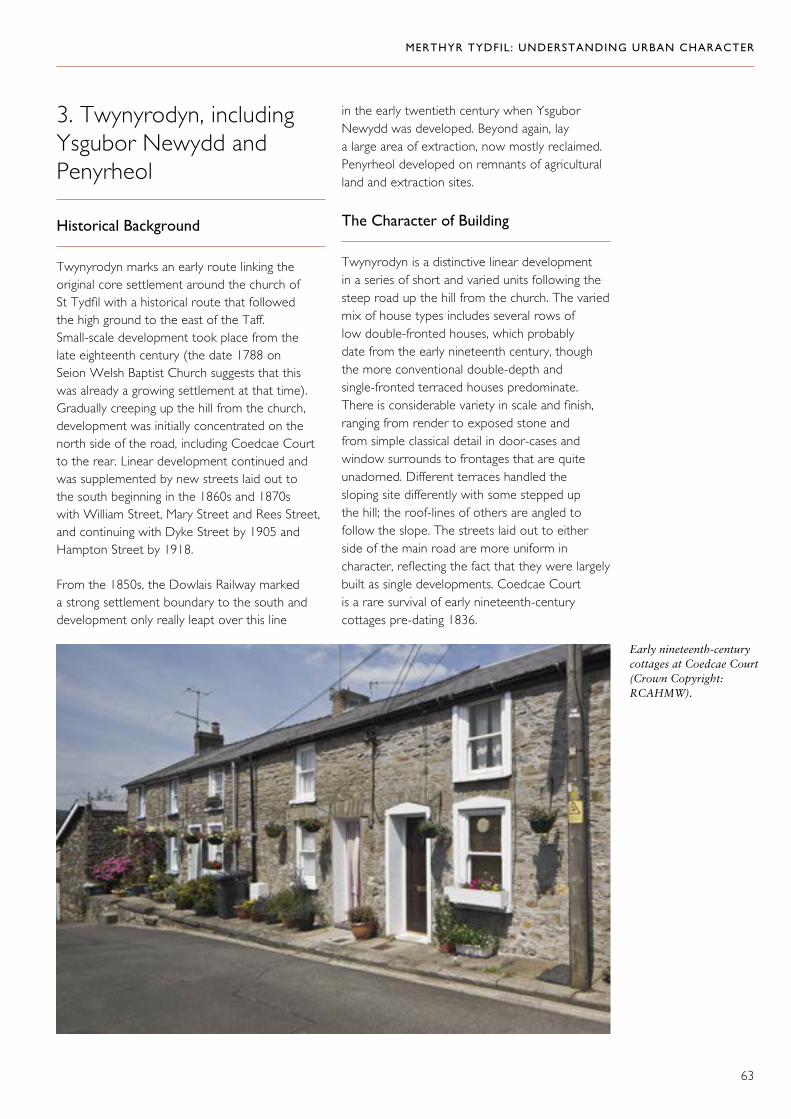
MERTHYR TYDFIL: UNDERSTANDING URBAN CHARACTER
63
3. Twynyrodyn, including Ysgubor Newydd and Penyrheol
Historical Background
Twynyrodyn marks an early route linking the original core settlement around the church of St Tydfil with a historical route that followed the high ground to the east of the Taff. Small-scale development took place from the late eighteenth century (the date 1788 on Seion Welsh Baptist Church suggests that this was already a growing settlement at that time).Gradually creeping up the hill from the church, development was initially concentrated on the north side of the road, including Coedcae Court to the rear. Linear development continued and was supplemented by new streets laid out to the south beginning in the 1860s and 1870s with William Street, Mary Street and Rees Street, and continuing with Dyke Street by 1905 and Hampton Street by 1918.
From the 1850s, the Dowlais Railway marked a strong settlement boundary to the south and development only really leapt over this line
in the early twentieth century when Ysgubor Newydd was developed. Beyond again, lay a large area of extraction, now mostly reclaimed. Penyrheol developed on remnants of agricultural land and extraction sites.
The Character of Building
Twynyrodyn is a distinctive linear development in a series of short and varied units following the steep road up the hill from the church. The varied mix of house types includes several rows of low double-fronted houses, which probably date from the early nineteenth century, though the more conventional double-depth and single-fronted terraced houses predominate. There is considerable variety in scale and finish, ranging from render to exposed stone and from simple classical detail in door-cases and window surrounds to frontages that are quite unadorned. Different terraces handled the sloping site differently with some stepped up the hill; the roof-lines of others are angled to follow the slope. The streets laid out to either side of the main road are more uniform in character, reflecting the fact that they were largely built as single developments. Coedcae Court is a rare survival of early nineteenth-century cottages pre-dating 1836.
Early nineteenth-century cottages at Coedcae Court (Crown Copyright: RCAHMW).

MERTHYR TYDFIL: UNDERSTANDING URBAN CHARACTER
64
The varied building pattern of Twynyrodyn Road (Crown Copyright: RCAHMW).

MERTHYR TYDFIL: UNDERSTANDING URBAN CHARACTER
65
4. South of the Town Centre: Plymouth Street Area
Historical Background
The Plymouth Ironworks was located to the south of this area. In the early nineteenth century, housing was built ribbon-fashion along Plymouth Street as one of the arteries connecting the town centre with the ironworks and the settlement of Pentrebach beyond it. This was the Plymouth toll road of around 1771. In 1841, the Taff Vale Railway was built along the eastern bank of the river to its terminus at the northern end of Plymouth Street. The Penydarren tramroad was another important artery and the route survives as Tramroadside South. The Plymouth feeder, carrying water from the Taff to the ironworks, ran to the west of the housing along Plymouth Street. The area between it and the Taff Vale Railway was used for tipping until the late nineteenth century, when it was redeveloped. Warlow Street, Ernest Street and Clare Street were built on the site of long plots behind haphazard terraces along the main road, the feeder, and old tips. Later, some of the linear development along Plymouth Street was also cleared. Twentieth-century housing development at Milbourne Close occupies the site of Plymouth House.
The Character of Building
The development of early industrial transport links has dictated the layout of the area. Bounded by the river Taff and the railway on the west, the Plymouth toll road (Plymouth Street) and the Penydarren tramroad (now Tramroadside South) have survived as north–south aligned routes. Although these were once arteries for development, the main area where traditional housing has survived is in a block of streets between the main road and the railway, built in the late nineteenth century as long terraced rows of single-fronted houses.
The planned housing development of Ernest Street and Clare Street has a uniformity of scale and layout, with parallel rows separated by a back lane. Despite a high level of alteration, including changes to wall finish and roofing, some original detail
survives here and there, including hood-moulds and raised rendered surrounds to windows and doorways.
There are similar terraces along Plymouth Street (Eastfield Terrace), where the houses have small front gardens and some have bay windows, and on Railway Terrace. Some of this housing retains its original exposed stone finish, with distinctive rusticated stone architraves to doors and windows.
5. Cyfarthfa: Park and Ironworks
Historical Background
Although not the first of the ironworks to be established, Cyfarthfa quickly achieved a pre-eminent role in the economy and landscape of Merthyr Tydfil. Founded by Anthony Bacon in 1765, it was eventually taken over by Richard Crawshay in 1794 and he presided over a rapid increase in production that included the establishment of the works at Ynysfach. The ironworks at Cyfarthfa continued to expand into the 1830s and there was major investment in the 1880s when new furnaces were built for the production of steel. The works closed in 1910 and the site was finally abandoned in 1921. The ironworks themselves comprised a vast and complex industrial site on both sides of the river, including processing and finishing works as well as the furnaces themselves. It was supplied with raw materials, including water, principally from the extractive landscape to the west, but also from Gurnos to the north. Transport routes bringing in these materials converged on the ironworks, and other routes took goods out. Foremost amongst these was the Glamorganshire Canal, whose terminus was adjacent to the works.
If Cyfarthfa Ironworks was the working heart of a vast landholding, the castle and park were its domestic counterpart. In the early days of the ironworks, the Crawshays had lived at Cyfarthfa House, which had been built by Anthony Bacon close to the works themselves, but from around 1810 they had a house somewhat further away at Gwaelod y Garth. William Crawshay II was responsible for a huge expansion of the ironworks, matched on the domestic front by the construction of the castle and establishment

MERTHYR TYDFIL: UNDERSTANDING URBAN CHARACTER
66
of the park. The mansion was built in 1825, designed by Robert Lugar as a mock castle in a romantic spirit that was deemed apt for its setting, intentionally overlooking the ironworks. The original park associated with the house was very extensive with 600 acres (245.4 hectares) and its ornamental core was retained as a public park when the house was acquired by the local corporation in 1909. The park provided an appropriate landscape setting for the mansion and a rural foil to the industrial landscape beyond it, but it also provided resources for the ironworks — the lake doubled as a holding pond for the water supply to the works, carried on a leat that crossed the river on Pont y Cafnau.
The Character of Building
The remains of the Cyfarthfa furnaces are extraordinarily impressive monuments to a once great industry, but all the associated structures below and above the furnaces on both sides of the river have been swept away. An industrial estate occupies the working area on the east bank of the Taff, but the land immediately surrounding the furnaces remains vacant and derelict. Extensive archaeological evidence of the former working area below the furnaces has been recovered and there is considerable potential for more.
Aerial view of the castle, showing the castle, park and lake, which was originally part of the water supply for the ironworks (Crown Copyright: RCAHMW).
The site of Cyfarthfa Ironworks from the air in 2007 (Crown Copyright: RCAHMW).

MERTHYR TYDFIL: UNDERSTANDING URBAN CHARACTER
67
Cyfarthfa Castle is a large mansion in a picturesque castellated style. The complex includes the original stable block and other outbuildings, rising above a terraced forecourt. The park itself retains many of the elements of its nineteenth-century layout and composition, including the lake and a series of reservoirs to the north-east of the house. To the west,
part of the original boundary wall also survives as does Pandy Farm almost opposite the main entrance. This was one of the principal farms on the estate, remodelled to create a picturesque composition when the castle was built. The farm, together with the ironworks, was an important component of the view from the castle as well as its economy.
Cyfarthfa Castle depicted around 1835 by Henry Gastineau (By permission of Llyfrgell Genedlaethol/National Library of Wales).
The picturesque appearance of Pandy Farm signals its role as part of the Cyfarthfa estate (Crown Copyright: RCAHMW).

MERTHYR TYDFIL: UNDERSTANDING URBAN CHARACTER
68
6. Williamstown, Cae Pant Tywll and Morgantown
Historical Background
Williamstown developed as the settlement most closely associated with the Cyfarthfa Ironworks. Development started in the late eighteenth century and was virtually complete by 1836. It began as a linear development along Brecon Road, which was in place by 1814. Examples of this early development survive at Quarry Row and Castle Square. Bethesda Street was another artery for linear development, originally the line of a tramroad from the Penydarren Ironworks to the canal, which crossed the river at Jackson’s Bridge. By 1836, the original linear settlement pattern had begun to extend onto small blocks of land to either side, including in the vicinity of a small quarry at the Quar (bounded by Tydfil’s Well Street and Gwaelodygarth Road). A few years later, Morgantown had also been laid out. The land east of Tydfil’s Well Street formed part of Penydarren Park and was only released for building in the late nineteenth century when a new grid pattern of streets was set out (see Penydarren pp. 70–76).
Most of the historical development pattern to the north of Brecon Road survives, as it does in Morgantown to the south, but most of Williamstown was redeveloped in the later twentieth century, with the exception of one long terrace (22–30 Cyfarthfa Road, built between1836 and 1851). A network of new roads and redevelopment between Bethesda Street and Nant Morlais has altered the original connectivity that linked this area directly with the west bank of the Taff, via Jackson’s Bridge.
The Character of Building
Early cottages at the Quar and Morgantown are mostly double-fronted and single-fronted small cottages, some retaining exposed stone fronts. Terraces at the Quar are informal and crowded, and many of the houses are very small, but Morgantown represents a more formally planned layout and introduces features that suggest formality of design, including hipped roofs on many corners and other corner detail. The houses here display good quality coursed and squared stonework.
Brecon Road displays the variety of development that is typical of early linear growth. Its long terraces are assembled as several discrete developments in a variety of date, scale, material and finish.
This terrace at Williamstown is an important example of early industrial housing directly associated with the Cyfarthfa Ironworks (Crown Copyright: RCAHMW).

MERTHYR TYDFIL: UNDERSTANDING URBAN CHARACTER
69
Early industrial housing at Castle Square (Crown Copyright: RCAHMW).
Distinctive early development at Grawen Terrace and Mount Street (Crown Copyright: RCAHMW).
Closely packed rows of cottages at Cae Pant Tywll (Crown Copyright: RCAHMW).
Formally planned development in Morgantown (Crown Copyright: RCAHMW).

MERTHYR TYDFIL: UNDERSTANDING URBAN CHARACTER
70
7. Penydarren
Historical Background
The Penydarren Ironworks was established by Francis Homfray in 1784. It was the centrepiece of an estate located on both sides of the Nant Morlais. The land to the south was exploited for raw materials to supply the ironworks, but the land to the north was largely retained as the parkland setting for
Penydarren House, built as the residence of the Homfray family in 1786. The house was used as a school in the late nineteenth century and was demolished in 1966.
The ironworks was the first to close, in 1859. The site was in ruins by the 1870s and was later partly built over with a tram depot (now an industrial estate) and housing (including Trevithick Street). The mineral workings to the south continued to be exploited into the twentieth century and the park to the north was gradually developed as a major new suburb.
Planned housing developments are a characteristic of Penydarren; Edgar Street is a typical example (Crown Copyright: RCAHMW).
Trevithick Street was built on the site of the Penydarren Ironworks in the late nineteenth century (Crown Copyright: RCAHMW).

MERTHYR TYDFIL: UNDERSTANDING URBAN CHARACTER
71
Penydarren Park was bounded to the south-west and south-east by Brecon Road and Pontmorlais Road, and to the north by Gwaelodygarth Road and Gwaelodygarth Lane (where there was some linear housing development). When Penydarren House fell out of residential use, most of the land was developed for housing from the late nineteenth century.
Stuart Street, Cromwell Street and Tudor Terrace had all been developed by 1905 and the grid of streets to the north was complete by 1919. The development of The Walk and the terraces to the west, The Grove, and the area around Meyrick Villas and West Grove, immediately south of Gwaelodygarth Road, established this part of Penydarren as an important middle-class suburb by 1919. Elements of earlier land use are traceable in the street pattern, where Gwaelodygarth Road is a survivor, and where the abrupt change in alignments on Llewellyn Street and Meyrick Villas marks the line of a former field boundary.
Meanwhile, further north, the original settlement of Penydarren, which grew up on the other side of Nant Morlais opposite the ironworks, comprised a linear development along High Street and Church Street, where some small cottage rows still survive. The land behind here was part of an agricultural landscape retained as part of the Cyfarthfa Castle and Penydarren House holdings, and it was not until the very end of the nineteenth century that it was released for development. In addition to planned, speculative house building, this was where the borough council built its first council houses. Larger-scale social housing projects were developed to the north of the area, particularly in the 1920s.
The Character of Building
The earliest surviving housing is along Church Street, Penydarren, where the long rows are a mix of scale of houses, though no original finish or detail survives. In the sloping streets behind, the terraced houses are more uniformly planned in regular roads with back lanes. The houses themselves have been extensively altered with modern renders and pebbledash, but there are occasional survivals of decorative render finishes to door and window surrounds, and a few surviving chimneys. By contrast, Council Street and Urban Street retain remarkable unity of finish
Above: The overall uniformity of Stuart Street gives it a strong character (Crown Copyright: RCAHMW).
Left: Striking examples of the larger houses built in Penydarren in the early years of the twentieth century: Meyrick Villas (top) and West Grove (below) (Crown Copyright: RCAHMW).
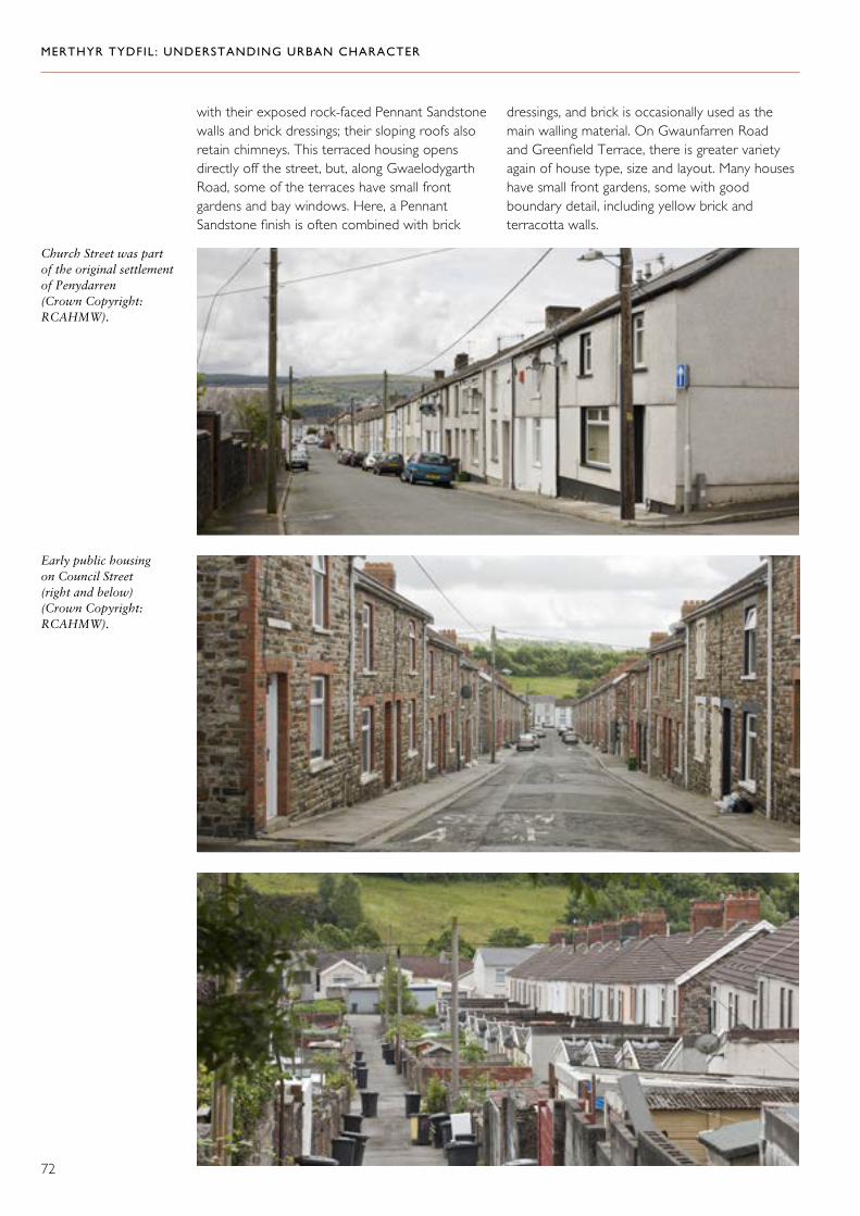
MERTHYR TYDFIL: UNDERSTANDING URBAN CHARACTER
72
with their exposed rock-faced Pennant Sandstone walls and brick dressings; their sloping roofs also retain chimneys. This terraced housing opens directly off the street, but, along Gwaelodygarth Road, some of the terraces have small front gardens and bay windows. Here, a Pennant Sandstone finish is often combined with brick
dressings, and brick is occasionally used as the main walling material. On Gwaunfarren Road and Greenfield Terrace, there is greater variety again of house type, size and layout. Many houses have small front gardens, some with good boundary detail, including yellow brick and terracotta walls.
Church Street was part of the original settlement of Penydarren (Crown Copyright: RCAHMW).
Early public housing on Council Street (right and below) (Crown Copyright: RCAHMW).

MERTHYR TYDFIL: UNDERSTANDING URBAN CHARACTER
73
Terraced housing on Gwaunfarren Road (Crown Copyright: RCAHMW).
Above left and right: Large villas on Gwaelodygarth Road.

MERTHYR TYDFIL: UNDERSTANDING URBAN CHARACTER
74
The northern part of this area favoured large suburban housing like these examples at Pentwyn Villas (middle and bottom) (Crown Copyright: RCAHMW).
Large terraced housing on Park Terrace (Crown Copyright: RCAHMW).

MERTHYR TYDFIL: UNDERSTANDING URBAN CHARACTER
75
The larger houses on Hadyn Terrace and Gwaunfarren Road, and in the area around The Walk and The Grove, display considerable variety of style, material and detail. They include
some bold designs, such as pairs with shared entrance features and gables, and examples of quirky render finishes. Water-worn limestone was favoured as a coping material for garden walls.
Left: A quirky detail in terracotta at Pembroke Place (Crown Copyright: RCAHMW).
Far left: Water-worn limestone copings on Haydn Terrace (Crown Copyright: RCAHMW).
The northern part of this area favoured large suburban housing like these examples at Pembroke Place (Crown Copyright: RCAHMW).

MERTHYR TYDFIL: UNDERSTANDING URBAN CHARACTER
76
Right: Brickwork on Lancaster Street: the continuous lean-to roof over the ground floor, garden walling with gate piers and water-worn limestone copings give this row a strong character (Crown Copyright: RCAHMW).
Above and above right: Distinctive detailing on houses on Tudor Terrace (Crown Copyright: RCAHMW).
Between Stuart Street – Cromwell Street – Tudor Terrace, The Walk and Gwaelodygarth Road, there is a remarkable variety of house types, beginning with relatively modest terraced houses on the lower streets, and culminating with substantial pairs and terraces of villas with gardens in the area around West Grove (built as a distinct development on a separate plot of land). Pennant Sandstone is the dominant walling material, but smooth render was used for some housing on Tudor Terrace, combined with bold architrave detail, and there are brick terraces on Lancaster Street. The status of these housing developments is indicated by the quality of detail and finish, where it survives.
Right: Larger terraced housing on Norman Terrace with exposed snecked stonework and matching garden walls (Crown Copyright: RCAHMW).
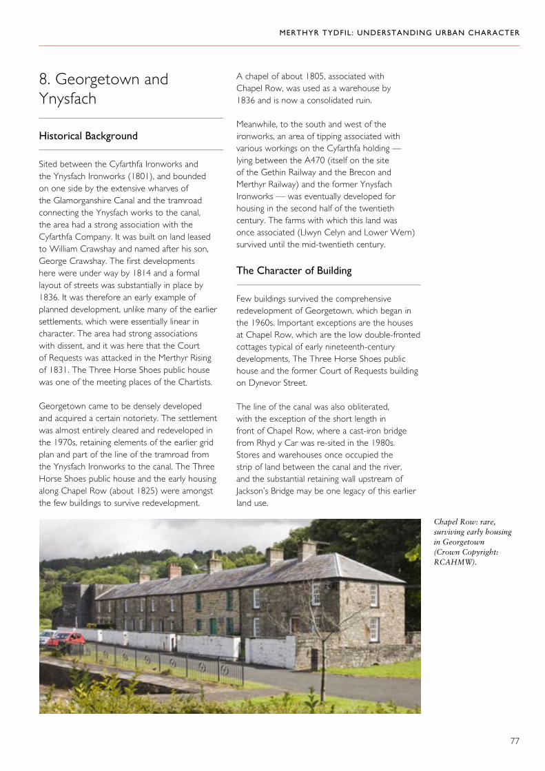
MERTHYR TYDFIL: UNDERSTANDING URBAN CHARACTER
77
8. Georgetown and Ynysfach
Historical Background
Sited between the Cyfarthfa Ironworks and the Ynysfach Ironworks (1801), and bounded on one side by the extensive wharves of the Glamorganshire Canal and the tramroad connecting the Ynysfach works to the canal, the area had a strong association with the Cyfarthfa Company. It was built on land leased to William Crawshay and named after his son, George Crawshay. The first developments here were under way by 1814 and a formal layout of streets was substantially in place by 1836. It was therefore an early example of planned development, unlike many of the earlier settlements, which were essentially linear in character. The area had strong associations with dissent, and it was here that the Court of Requests was attacked in the Merthyr Rising of 1831. The Three Horse Shoes public house was one of the meeting places of the Chartists.
Georgetown came to be densely developed and acquired a certain notoriety. The settlement was almost entirely cleared and redeveloped in the 1970s, retaining elements of the earlier grid plan and part of the line of the tramroad from the Ynysfach Ironworks to the canal. The Three Horse Shoes public house and the early housing along Chapel Row (about 1825) were amongst the few buildings to survive redevelopment.
A chapel of about 1805, associated with Chapel Row, was used as a warehouse by 1836 and is now a consolidated ruin.
Meanwhile, to the south and west of the ironworks, an area of tipping associated with various workings on the Cyfarthfa holding — lying between the A470 (itself on the site of the Gethin Railway and the Brecon and Merthyr Railway) and the former Ynysfach Ironworks — was eventually developed for housing in the second half of the twentieth century. The farms with which this land was once associated (Llwyn Celyn and Lower Wern) survived until the mid-twentieth century.
The Character of Building
Few buildings survived the comprehensive redevelopment of Georgetown, which began in the 1960s. Important exceptions are the houses at Chapel Row, which are the low double-fronted cottages typical of early nineteenth-century developments, The Three Horse Shoes public house and the former Court of Requests building on Dynevor Street.
The line of the canal was also obliterated, with the exception of the short length in front of Chapel Row, where a cast-iron bridge from Rhyd y Car was re-sited in the 1980s. Stores and warehouses once occupied the strip of land between the canal and the river, and the substantial retaining wall upstream of Jackson’s Bridge may be one legacy of this earlier land use.
Chapel Row: rare, surviving early housing in Georgetown (Crown Copyright: RCAHMW).
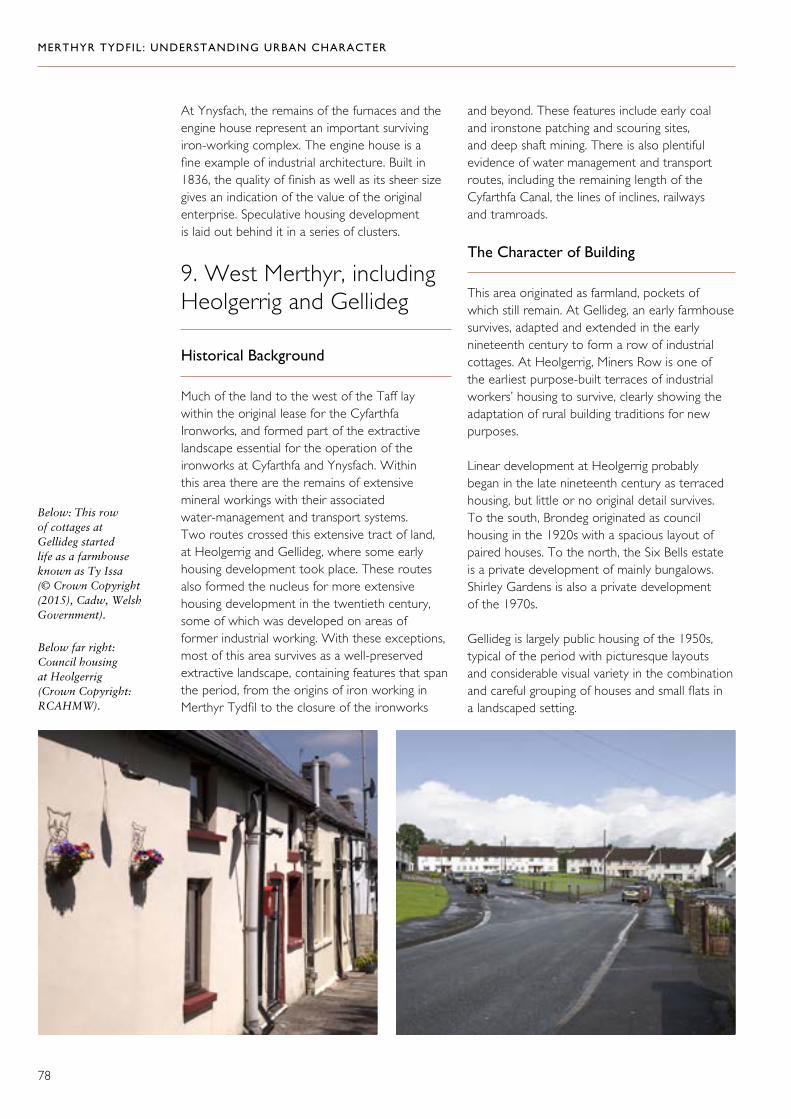
MERTHYR TYDFIL: UNDERSTANDING URBAN CHARACTER
78
At Ynysfach, the remains of the furnaces and the engine house represent an important surviving iron-working complex. The engine house is a fine example of industrial architecture. Built in 1836, the quality of finish as well as its sheer size gives an indication of the value of the original enterprise. Speculative housing development is laid out behind it in a series of clusters.
9. West Merthyr, including Heolgerrig and Gellideg
Historical Background
Much of the land to the west of the Taff lay within the original lease for the Cyfarthfa Ironworks, and formed part of the extractive landscape essential for the operation of the ironworks at Cyfarthfa and Ynysfach. Within this area there are the remains of extensive mineral workings with their associated water-management and transport systems. Two routes crossed this extensive tract of land, at Heolgerrig and Gellideg, where some early housing development took place. These routes also formed the nucleus for more extensive housing development in the twentieth century, some of which was developed on areas of former industrial working. With these exceptions, most of this area survives as a well-preserved extractive landscape, containing features that span the period, from the origins of iron working in Merthyr Tydfil to the closure of the ironworks
Below: This row of cottages at Gellideg started life as a farmhouse known as Ty Issa (© Crown Copyright (2015), Cadw, Welsh Government).
Below far right: Council housing at Heolgerrig (Crown Copyright: RCAHMW).
and beyond. These features include early coal and ironstone patching and scouring sites, and deep shaft mining. There is also plentiful evidence of water management and transport routes, including the remaining length of the Cyfarthfa Canal, the lines of inclines, railways and tramroads.
The Character of Building
This area originated as farmland, pockets of which still remain. At Gellideg, an early farmhouse survives, adapted and extended in the early nineteenth century to form a row of industrial cottages. At Heolgerrig, Miners Row is one of the earliest purpose-built terraces of industrial workers’ housing to survive, clearly showing the adaptation of rural building traditions for new purposes.
Linear development at Heolgerrig probably began in the late nineteenth century as terraced housing, but little or no original detail survives. To the south, Brondeg originated as council housing in the 1920s with a spacious layout of paired houses. To the north, the Six Bells estate is a private development of mainly bungalows. Shirley Gardens is also a private development of the 1970s.
Gellideg is largely public housing of the 1950s, typical of the period with picturesque layouts and considerable visual variety in the combination and careful grouping of houses and small flats in a landscaped setting.

MERTHYR TYDFIL: UNDERSTANDING URBAN CHARACTER
79
Merthyr Tydfil was not only the largest town in Wales, but also the iron and steel capital of the world in the mid-nineteenth century.58 It was here that the industrial revolution, centred on large-scale iron production, attained its most complete expression in the creation of an industrial landscape and way of life. Here, there was not only an integrated industrial landscape, but also a complex urban economy and society. In the wake of the economic collapse, which followed the decline of the iron industry and the enterprises associated with it in the twentieth century, redevelopment took its toll on the legacy of this proud history. The town of Merthyr Tydfil, however, retains a strong heritage of industry and especially of the urban culture that it generated.
The major industrial sites once physically dominated the landscape and the few surviving remains, though neglected, are still impressive. Much of the extractive landscape associated with the Cyfarthfa Ironworks survives to the west of the Taff, and there are fragments of similar landscapes elsewhere. Cyfarthfa Castle is a major monument to the astounding wealth generated by iron. Despite losses, the townscape itself is remarkably rich. It encompasses distinctive traditions of house building, from the early industrial cottage rows to early twentieth-century suburban villas and housing developments. Together, these chart more than a hundred years of ambitious urban expansion and the establishment of a diverse urban industrial society. In spite of some redevelopment, the town centre retains civic and commercial architecture of remarkable quality.
Historically, these components of the urban industrial landscape were tightly integrated. There was a mesh of transport and supply lines to and from the ironworks and other industrial sites, some of which also provided a framework for settlement. There were residential districts built originally in relation to individual enterprises, each with its own distinctive character and role within the life of the town, and sharing a focus on the town centre as it developed into the main civic, cultural and commercial hub.
Now, the industrial sites have been marginalized; historical transport routes severed, over-built or neglected; areas of historical settlement redeveloped and some key buildings abandoned. But regeneration activity has already begun to focus on the repair and reinstatement of historical routes and supply lines, on townscape and some of the principal buildings. Recognition of the integrated and interdependent character of this pre-eminent urban industrial landscape, encompassing industrial sites, routes, and residential and commercial districts, is fundamental to realizing the potential of Merthyr Tydfil to be heralded once again as one of the most remarkable industrial towns in Wales.
Statement of Significance

MERTHYR TYDFIL: UNDERSTANDING URBAN CHARACTER
80
Anon., Merthyr Tydfil Illustrated: A Descriptive Account of Merthyr (Brighton, 1893).
T. E. Clarke, A Guide to Merthyr Tydfil (London, 1848).
Charles Frederick Cliffe, The Book of South Wales, the Bristol Channel, Monmouthshire and the Wye (London, 1847).
Richard Crawshay, The Letterbook of Richard Crawshay 1788–1797 (Cardiff, 1990).
John Davies, A History of Wales (Harmondsworth, 1993).
John Davies and Jana Horák, ‘Building Stone Use in the Brecon Beacons National Park, Amgueddfa Cymru — National Museum Wales Report’ (Unpublished; Cardiff, 2009).
Leo Davies, ‘The Dowlais Railway or “Incline”’, Merthyr Historian, Vol. 8 (Merthyr Tydfil, 1996).
W. L. Davies, Bridges of Merthyr Tydfil (Cardiff, 1992).
A. Trystan Edwards, Merthyr, Rhondda and ‘The Valleys’ (London, 1958).
Diane Green, ‘Housing in Merthyr Tydfil’, Merthyr Historian, Vol. 2 (Merthyr Tydfil,1978).
Richard Hayman, Working Iron in Merthyr Tydfil (Merthyr Tydfil, 1989).
J. B. Hilling, ‘The Buildings of Merthyr Tydfil’, Glamorgan Historian, Vol. 8 (Barry, 1972).
Laurence Ince, The South Wales Iron Industry 1750–1885 (West Midlands, 1993).
Arthur H. John (ed.), Glamorgan County History, Vol. V, Industrial Glamorgan from 1700–1970 (Cardiff, 1980).
Benjamin Malkin, The Scenery, Antiquities and Biography of South Wales (London, 1804; reprint Wakefield, 1970).
Merthyr Teachers Centre Group, Merthyr Tydfil: A Valley Community (Cowbridge, 1981).
Alun Morgan, ‘Earning a Living: Industrial Development 1918–1939’ Merthyr Historian, Vol. 2 (Merthyr Tydfil, 1978).
John Newman, The Buildings of Wales: Glamorgan (London, 1995).
Paul O’Leary, Claiming the Streets: Processions and Urban Culture in South Wales, c.1830–80 (Cardiff, 2012).
Paul O’Leary, ‘Mass commodity culture and identity: the Morning Chronicle and Irish migrants in a Welsh nineteenth-century town’ Urban History, 35 2 (2008), 237–54.
John Owen, ‘Merthyr Tydfil Industrial Development, 1870–1914’, Merthyr Historian, Vol. 2 (Merthyr Tydfil, 1978).
Gordon Rattenbury, ‘Merthyr Tydfil Tramroads and Their Locomotives’, Merthyr Historian, Vol. 7 (Merthyr Tydfil, 1994).
Isaac Slater, Slater’s Royal National and Commercial Directory and Topography of the Counties of Gloucester, Hereford, Monmouth and Shropshire, and North and South Wales (London, 1868).
Eira Smith, ‘Turnpikes and Toll Gates’, in Huw Williams (ed.), Merthyr Tydfil: Drawn from Life (Merthyr Tydfil, 1981).
Keith Strange, Merthyr Tydfil Iron Metropolis: Life in a Welsh Industrial Town (Stroud, 2005).
Charles Wilkins, The History of Merthyr Tydfil (Merthyr Tydfil, 1867).
Selected Sources

MERTHYR TYDFIL: UNDERSTANDING URBAN CHARACTER
81
1. Isaac Slater, Slater’s Royal National and Commercial Directory and Topography of the Counties of Gloucester, Hereford, Monmouth, Shropshire, and North and South Wales (London, 1868).
2. J. B. Hilling, ‘The Buildings of Merthyr Tydfil’, Glamorgan Historian, Vol. 8 (Barry, 1972); Merthyr Teachers Centre Group, Merthyr Tydfil: A Valley Community (Cowbridge, 1981).
3. Charles Wilkins, The History of Merthyr Tydfil (Merthyr Tydfil, 1867).
4. Merthyr Teachers Centre Group, Merthyr Tydfil: A Valley Community (Cowbridge, 1981).
5. Ibid.
6. Charles Wilkins, The History of Merthyr Tydfil (Merthyr Tydfil, 1867).
7. Ibid.
8. F. J. Pedler, History of the Hamlet of Gellideg (Merthyr Tydfil, 1930).
9. Charles Wilkins, The History of Merthyr Tydfil (Merthyr Tydfil, 1867).
10. Merthyr Teachers Centre Group, Merthyr Tydfil: A Valley Community (Cowbridge, 1981).
11. John Davies, A History of Wales (Harmondsworth, 1993).
12. Charles Wilkins, The History of Merthyr Tydfil (Merthyr Tydfil, 1867).
13. Keith Strange, Merthyr Tydfil Iron Metropolis: Life in a Welsh Industrial Town (Stroud, 2005).
14. Richard Crawshay, The Letterbook of Richard Crawshay 1788–1797 (Cardiff, 1990).
15. Laurence Ince, The South Wales Iron Industry 1750–1885 (West Midlands, 1993); Arthur H. John (ed.), Glamorgan County History, Vol. V: Industrial Glamorgan, from 1700–1970 (Cardiff, 1980).
16. A. Trystan Edwards, Merthyr, Rhondda and ‘The Valleys’ (London, 1958).
17. Arthur H. John (ed.), Glamorgan County History, Vol. V: Industrial Glamorgan, from 1700–1970 (Cardiff, 1980).
18. Charles Frederick Cliffe, The Book of South Wales, The Bristol Channel, Monmouthshire and the Wye (London, 1847).
19. John Owen, ‘Merthyr Tydfil Industrial Development, 1870–1914’, Merthyr Historian, Vol. 2 (Merthyr Tydfil, 1978).
20. Isaac Slater, Slater’s Royal National and Commercial Directory and Topography of the Counties of Gloucester, Hereford, Monmouth, Shropshire, and North and South Wales (London, 1868).
21. W. L. Davies, Bridges of Merthyr Tydfil (Cardiff, 1992); Eira Smith, ‘Turnpikes and Toll Gates’, in Huw Williams (ed.), Merthyr Tydfil: Drawn from Life (Merthyr Tydfil, 1981).
22. Gordon Rattenbury, ‘Merthyr Tydfil Tramroads and Their Locomotives’, Merthyr Historian, Vol. 7 (Merthyr Tydfil, 1994).
23. Ibid.
24. Arthur H. John, (ed.), Glamorgan County History, Vol. V: Industrial Glamorgan, from 1700–1970 (Cardiff, 1980); Merthyr Teachers Centre Group, Merthyr Tydfil: A Valley Community (Cowbridge, 1981).
25. Leo Davies, ‘The Dowlais Railway and Incline’, Merthyr Historian, Vol. 8 (Merthyr Tydfil, 1996).
26. Merthyr Teachers Centre Group, Merthyr Tydfil: A Valley Community (Cowbridge, 1981).
Endnotes

MERTHYR TYDFIL: UNDERSTANDING URBAN CHARACTER
82
27. Benjamin Malkin, The Scenery, Antiquities and Biography of South Wales (London 1804; reprint Wakefield, 1970).
28. Charles Frederick Cliffe, The Book of South Wales, The Bristol Channel, Monmouthshire and the Wye (London, 1847).
29. T. E. Clarke, A Guide to Merthyr Tydfil (London, 1848).
30. Arthur H. John (ed.), Glamorgan County History, Vol. V: Industrial Glamorgan, from 1700–1970 (Cardiff, 1980).
31. Benjamin Malkin, The Scenery, Antiquities and Biography of South Wales (London 1804; reprint Wakefield, 1970).
32. Charles Frederick Cliffe, The Book of South Wales, The Bristol Channel, Monmouthshire and the Wye (London, 1847).
33. Keith Strange, Merthyr Tydfil Iron Metropolis: Life in a Welsh Industrial Town (Stroud, 2005).
34. Benjamin Malkin, The Scenery, Antiquities and Biography of South Wales (London 1804; reprint Wakefield, 1970).
35. Lugar, the architect of Cyfarthfa Castle, quoted in J. B. Hilling, ‘The Buildings of Merthyr Tydfil’, Glamorgan Historian, Vol. 8 (Barry, 1972).
36. Benjamin Malkin, The Scenery, Antiquities and Biography of South Wales (London 1804; reprint Wakefield, 1970).
37. T. E. Clarke, A Guide to Merthyr Tydfil (London, 1848).
38. Paul O’Leary, ‘Mass commodity culture and identity: the Morning Chronicle and Irish migrants in a Welsh nineteenth-century town’ Urban History, 35 2 (2008), 237–54.
39. Anon., Merthyr Tydfil Illustrated: A Descriptive Account of Merthyr (Brighton, 1893).
40. John Davies, A History of Wales (Harmondsworth, 1993); information from Carolyn Jacob, Merthyr Tydfil Public Library Services.
41. Keith Strange, Merthyr Tydfil Iron Metropolis: Life in a Welsh Industrial Town (Stroud, 2005).
42. A. Trystan Edwards, Merthyr, Rhondda and ‘The Valleys’ (London, 1958).
43. Ibid.
44. Keith Strange, Merthyr Tydfil Iron Metropolis: Life in a Welsh Industrial Town (Stroud, 2005).
45. Ibid.; Alun Morgan, ‘Earning a Living: Industrial Development 1918-1939’ Merthyr Historian, Vol. 2 (Merthyr Tydfil, 1978).
46. A. Trystan Edwards, Merthyr, Rhondda and ‘The Valleys’ (London, 1958); Merthyr Teachers Centre Group, Merthyr Tydfil: A Valley Community (Cowbridge, 1981).
47. T. E. Clarke, A Guide to Merthyr Tydfil (London, 1848).
48. Ibid.
49. Information from Carolyn Jacob, Merthyr Tydfil Public Library Services.
50. Arthur H. John (ed.), Glamorgan County History, Vol. V: Industrial Glamorgan, from 1700–1970 (Cardiff, 1980); Keith Strange, Merthyr Tydfil Iron Metropolis: Life in a Welsh Industrial Town (Stroud, 2005).
51. T. E. Clarke, A Guide to Merthyr Tydfil (London, 1848).
52. The Morning Chronicle, 180, quoted in Keith Strange, Merthyr Tydfil Iron Metropolis: Life in a Welsh Industrial Town (Stroud, 2005).
53. Quoted in Keith Strange, Merthyr Tydfil Iron Metropolis: Life in a Welsh Industrial Town (Stroud, 2005).

MERTHYR TYDFIL: UNDERSTANDING URBAN CHARACTER
83
54. Keith Strange, Merthyr Tydfil Iron Metropolis: Life in a Welsh Industrial Town (Stroud, 2005).
55. Ibid.
56. Wirt Sikes, Rambles and Studies in Old South Wales (London, 1881).
57. A. Trystan Edwards, Merthyr, Rhondda and ‘The Valleys’ (London, 1958).
58. Peter Sager, Wales (London, 2002).

MERTHYR TYDFIL: UNDERSTANDING URBAN CHARACTER
84
1 All Character Areas with Historic Environment Designations

MERTHYR TYDFIL: UNDERSTANDING URBAN CHARACTER
2 All Character Areas
85
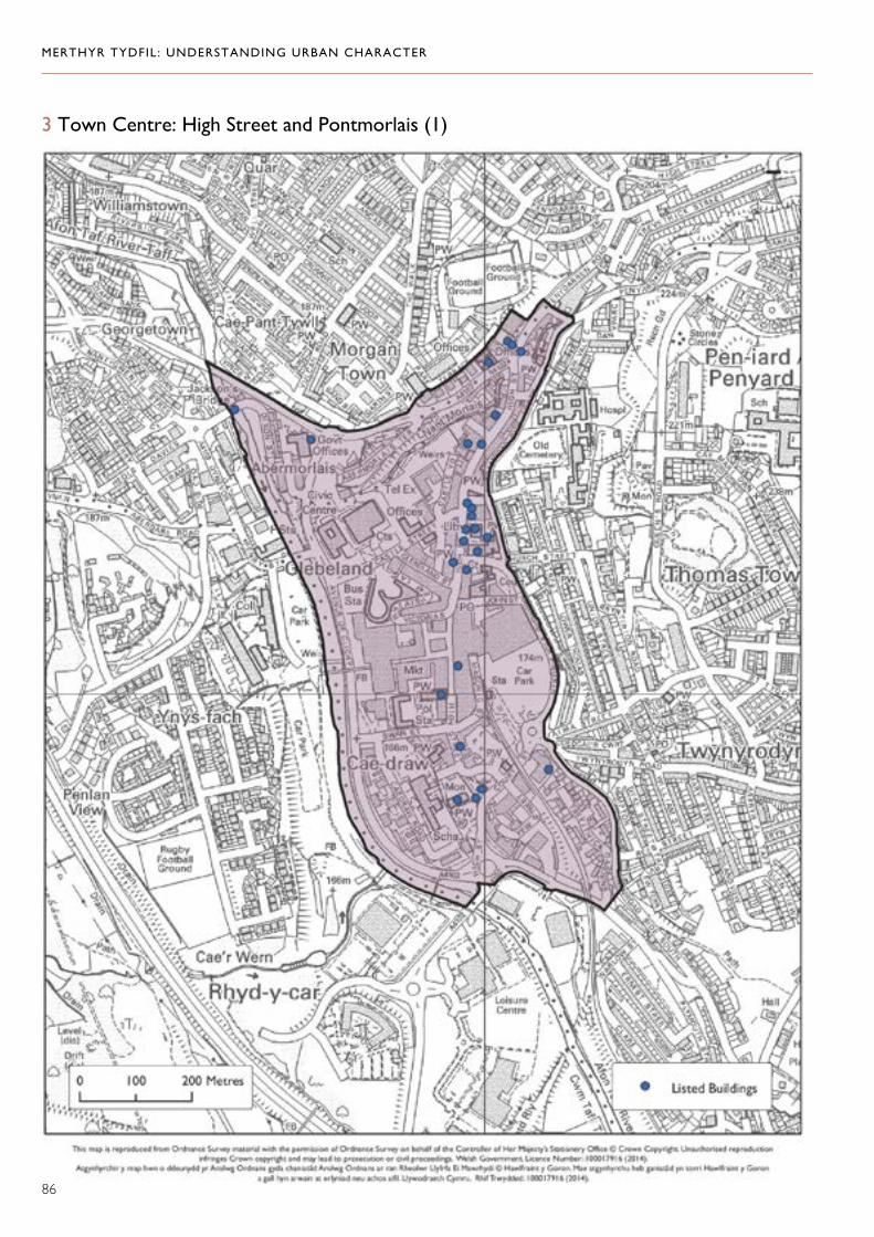
MERTHYR TYDFIL: UNDERSTANDING URBAN CHARACTER
86
3 Town Centre: High Street and Pontmorlais (1)

MERTHYR TYDFIL: UNDERSTANDING URBAN CHARACTER
87
4 Thomastown and Penyard (2)
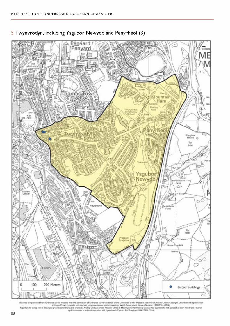
MERTHYR TYDFIL: UNDERSTANDING URBAN CHARACTER
5 Twynyrodyn, including Ysgubor Newydd and Penyrheol (3)
88
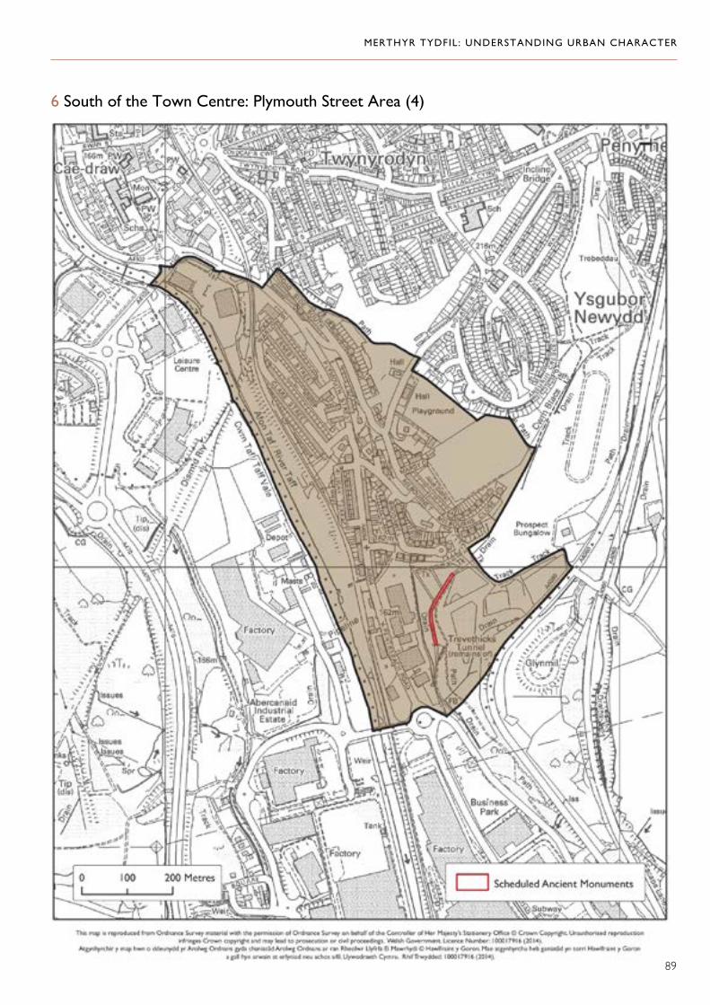
MERTHYR TYDFIL: UNDERSTANDING URBAN CHARACTER
6 South of the Town Centre: Plymouth Street Area (4)
89

MERTHYR TYDFIL: UNDERSTANDING URBAN CHARACTER
7 Cyfarthfa: Park and Ironworks (5)
90

MERTHYR TYDFIL: UNDERSTANDING URBAN CHARACTER
8 Williamstown, Cae Pant Tywll and Morgantown (6)
91

MERTHYR TYDFIL: UNDERSTANDING URBAN CHARACTER
9 Penydarren (7)
92

MERTHYR TYDFIL: UNDERSTANDING URBAN CHARACTER
10 Georgetown and Ynysfach (8)
93

MERTHYR TYDFIL: UNDERSTANDING URBAN CHARACTER
11 West Merthyr, including Heolgerrig and Gellideg (9)
94