message from the seashore’s superintendent - … from the seashore’s superintendent dear...
TRANSCRIPT

Newsletter No. 2 | Summer 2011 | 1
Message from the Seashore’s SuperintendentDear Partners,
Created by Congress in 1965, Assateague Island National Seashore was established to preserve the outstanding Mid-Atlantic coastal resources of Assateague Island and its adjacent waters and the natural processes upon which they depend, and to provide high quality resource-compatible recreational opportunities. To support these purposes, the National Park Service is preparing a new General Management Plan (GMP) for the seashore. The GMP will establish a vision for the seashore and provide broad guidance for its manage-ment over the next 15 to 20 years.
In the summer and fall of 2009, we met with you and asked for your thoughts and ideas for the plan. The comments we received helped us understand what was important to you and the scope of issues to be addressed in the plan. Mindful of the input we received, the planning team has crafted several preliminary manage-ment alternatives, or options for how we will go about protecting the seashore’s
resources while continuing to provide recreational opportunities. In this second GMP newsletter we present summaries of those preliminary alternatives, and review the planning process and management issues that led to their development.
In crafting the alternatives we chose to consider climate change and sea level rise as key factors influencing the future of the seashore. While there is uncertainty about the future pace of climate change and sea level rise, there is near consensus among the scientific community that change is underway. Barrier islands such as Assateague will be especially vulnerable to the effects of climate change and sea level rise, and we must be able to respond effectively. Although major impacts are not expected in the near term, now is the time to set the stage so that future managers have the options available when condi-tions and circumstances do change.
This summer we will hold several open house workshops in communities near the seashore so that you can review and comment on the proposed alternatives. We encourage you to take time from your busy schedule to participate in this important process and provide us with feedback. As the Superintendent of Assateague, I look forward to hearing your thoughts and working together in planning the future of the seashore.
Sincerely,
Trish Kicklighter, Superintendent Assateague Island National Seashore
Assateague Island National SeashoreGeneral Management Plan / Environmental Impact Statement
National Park ServiceU.S. Department of the Interior
Newsletter #2, Summer 2011

Newsletter No. 2 | Summer 2011 | 2
StAtuS of our PlANNING ProcESS A General Management Plan (GMP) iden-tifies the overall direction for the future management of units of the National Park System. GMPs take a long-range, broad, conceptual view, answering the question, “What kind of place do we want this park to be?” They provide a framework for managers to use in making decisions about how best to protect park natural and cultural resources, what levels and types of uses are appropriate, what facilities should be developed, and how people should ac-cess the park. All concepts, strategies, and actions in a GMP must be consistent with the reasons for the park’s establishment by Congress – its purpose and significance.
Our planning work began with developing a foundation statement, which is the first step in the GMP effort. The foundation statement reflects the seashore’s purpose, significance, fundamental resources and values, as well as interpretive themes. It helps keep the park’s management focused on what is most important about this place and the reasons why it was established as a national seashore. Next, the planning
team moved into an analysis of current resource conditions at the park. We identified, mapped, and analyzed current conditions, existing and potential future threats, stakeholder interests, ideas and suggestions from the public, related laws and policies, and identified any data gaps related to the seashore’s fundamental resources and values.
Recognizing that there are many ways to preserve and protect Assateague Island National Seashore, to provide rich visitor experiences, and to tell its many stories, the planning team has developed several draft alternative management concepts. These are preliminary concepts and we look forward to your input and comments.
NExt StEPS
Based on what we hear from you, we may refine the alternative concepts and add additional elements or details. Next, the alternatives will be analyzed for impacts to the social, cultural, and natural environ-ments in the Draft General Management Plan/Environmental Impact Statement. At that time, a “best” or “preferred” alterna-tive will be identified.
Please join us for a drop-in style open house workshop to review the preliminary alternative management concepts for the Assateague Island National Seashore GMP.
August 16, 2011 - 4:30-7:30PM Wor-Wic Community College Workforce Development Center, Room 103-A 32000 campus Drive | Salisbury, Maryland
August 17, 2011 - 4:30-7:30PM The Marine Science Consortium, Education Center Auditorium 34001 Mill Dam road | Wallops Island, Virginia (The Education Center fronts on Mill Dam Road, and is a large building with a glass entry tower)
August 18, 2011 - 6:00-9:00PM Ocean Pines Branch Library, Large Meeting Room 11107 cathell road | ocean Pines, Maryland
Newsletter No. 2 | Summer 2011 | 3
SIGNIfIcANcE
Significance statements explain why the park’s resources and features are important enough to merit national park designation.
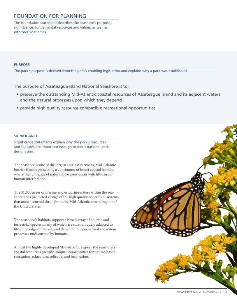
The seashore is one of the largest and last surviving Mid-Atlantic barrier islands possessing a continuum of intact coastal habitats where the full range of natural processes occur with little or no human interference.
The 31,000 acres of marine and estuarine waters within the sea-shore are a protected vestige of the high quality aquatic ecosystems that once occurred throughout the Mid-Atlantic coastal region of the United States.
The seashore’s habitats support a broad array of aquatic and terrestrial species, many of which are rare, uniquely adapted to life at the edge of the sea, and dependent upon natural ecosystem processes undisturbed by humans.
Amidst the highly developed Mid-Atlantic region, the seashore’s coastal resources provide unique opportunities for nature-based recreation, education, solitude, and inspiration.
fouNDAtIoN for PlANNINGthe foundation statement describes the seashore’s purpose, significance, fundamental resources and values, as well as interpretive themes.
PurPoSE
the park’s purpose is derived from the park’s enabling legislation and explains why a park was established.
the purpose of Assateague Island National Seashore is to:
preserve the outstanding Mid-Atlantic coastal resources of Assateague Island and its adjacent waters •and the natural processes upon which they depend
provide high quality resource-compatible recreational opportunities•
Newsletter No. 2 | Summer 2011 | 4
fuNDAMENtAl rESourcES
fundamental resources and values are the features, systems, processes, experi-ences, stories, scenes, sounds, or other resources and values determined to warrant primary consideration during planning and management because they are critical to achieving the park’s purpose and maintaining its significance. these resources and values should col-lectively capture the essence of the park.
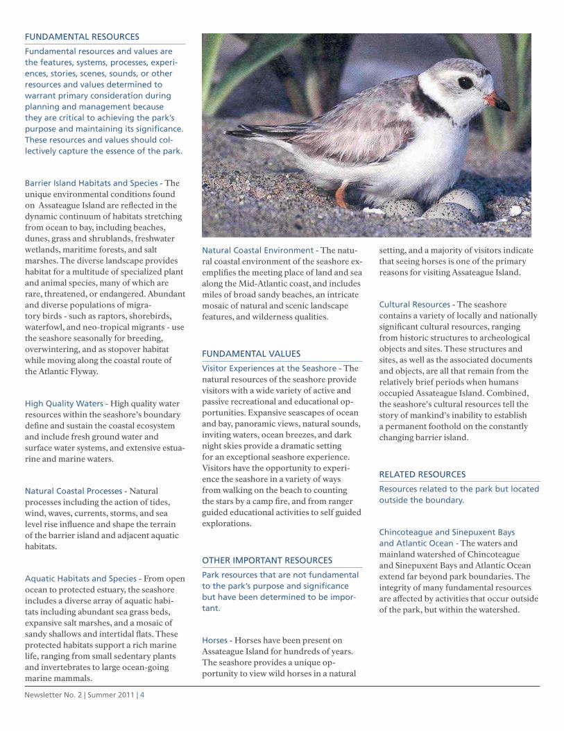
Barrier Island Habitats and Species - The unique environmental conditions found on Assateague Island are reflected in the dynamic continuum of habitats stretching from ocean to bay, including beaches, dunes, grass and shrublands, freshwater wetlands, maritime forests, and salt marshes. The diverse landscape provides habitat for a multitude of specialized plant and animal species, many of which are rare, threatened, or endangered. Abundant and diverse populations of migra-tory birds - such as raptors, shorebirds, waterfowl, and neo-tropical migrants - use the seashore seasonally for breeding, overwintering, and as stopover habitat while moving along the coastal route of the Atlantic Flyway.
High Quality Waters - High quality water resources within the seashore’s boundary define and sustain the coastal ecosystem and include fresh ground water and surface water systems, and extensive estua-rine and marine waters.
Natural coastal Processes - Natural processes including the action of tides, wind, waves, currents, storms, and sea level rise influence and shape the terrain of the barrier island and adjacent aquatic habitats.
Aquatic Habitats and Species - From open ocean to protected estuary, the seashore includes a diverse array of aquatic habi-tats including abundant sea grass beds, expansive salt marshes, and a mosaic of sandy shallows and intertidal flats. These protected habitats support a rich marine life, ranging from small sedentary plants and invertebrates to large ocean-going marine mammals.
Natural coastal Environment - The natu-ral coastal environment of the seashore ex-emplifies the meeting place of land and sea along the Mid-Atlantic coast, and includes miles of broad sandy beaches, an intricate mosaic of natural and scenic landscape features, and wilderness qualities.
fuNDAMENtAl VAluES
Visitor Experiences at the Seashore - The natural resources of the seashore provide visitors with a wide variety of active and passive recreational and educational op-portunities. Expansive seascapes of ocean and bay, panoramic views, natural sounds, inviting waters, ocean breezes, and dark night skies provide a dramatic setting for an exceptional seashore experience. Visitors have the opportunity to experi-ence the seashore in a variety of ways from walking on the beach to counting the stars by a camp fire, and from ranger guided educational activities to self guided explorations.
otHEr IMPortANt rESourcES
Park resources that are not fundamental to the park’s purpose and significance but have been determined to be impor-tant.
Horses - Horses have been present on Assateague Island for hundreds of years. The seashore provides a unique op-portunity to view wild horses in a natural
setting, and a majority of visitors indicate that seeing horses is one of the primary reasons for visiting Assateague Island.
cultural resources - The seashore contains a variety of locally and nationally significant cultural resources, ranging from historic structures to archeological objects and sites. These structures and sites, as well as the associated documents and objects, are all that remain from the relatively brief periods when humans occupied Assateague Island. Combined, the seashore’s cultural resources tell the story of mankind’s inability to establish a permanent foothold on the constantly changing barrier island.
rElAtED rESourcES
resources related to the park but located outside the boundary.
chincoteague and Sinepuxent Bays and Atlantic ocean - The waters and mainland watershed of Chincoteague and Sinepuxent Bays and Atlantic Ocean extend far beyond park boundaries. The integrity of many fundamental resources are affected by activities that occur outside of the park, but within the watershed.

Newsletter No. 2 | Summer 2011 | 5
INtErPrEtIVE tHEMES
Primary interpretive themes describe broad concepts to be interpreted to provide people and visitors with opportu-nities to understand and appreciate park resources.
Island on the Move - Change is the only constant on Assateague Island as wind and water move and transform the land and its plant and animal communities. Adapting to change on a barrier island is the key to survival in this place where dynamic forces control the process of life.
Aquatic legacies - Assateague’s shoreline is a constantly shifting boundary between land and water where we connect to the rest of the world through a shared ocean resource which provides oxygen, food, habitat, livelihood, recreation and glimpses of our past. There is just one intermingled and irreplaceable ocean that sustains these aspects of life on earth.
People and Place - People have long relied on Assateague Island for survival, liveli-hood, community, and enjoyment. Those who have spent time on and around the island have changed it and been changed by it.
recreation and Stewardship - Assateague Island provides a diverse range of recre-ational opportunities which are compatible with the National Park Service (NPS) dual mission of conservation and public access. Immersion in an unspoiled natural setting cultivates profound experiences and special memories, the foundation of a stewardship ethic.
ChAngE iS ThE OnLy COnSTAnT On ASSATEAguE iSLAnD AS WinD AnD WATER MOvE AnD TRAnSfORM ThE LAnD AnD iTS PLAnT AnD AniMAL COMMuniTiES.
Newsletter No. 2 | Summer 2011 | 6
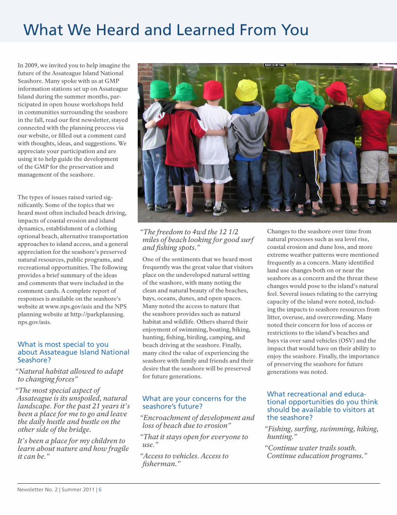
In 2009, we invited you to help imagine the future of the Assateague Island National Seashore. Many spoke with us at GMP information stations set up on Assateague Island during the summer months, par-ticipated in open house workshops held in communities surrounding the seashore in the fall, read our first newsletter, stayed connected with the planning process via our website, or filled out a comment card with thoughts, ideas, and suggestions. We appreciate your participation and are using it to help guide the development of the GMP for the preservation and management of the seashore.
The types of issues raised varied sig-nificantly. Some of the topics that we heard most often included beach driving, impacts of coastal erosion and island dynamics, establishment of a clothing optional beach, alternative transportation approaches to island access, and a general appreciation for the seashore’s preserved natural resources, public programs, and recreational opportunities. The following provides a brief summary of the ideas and comments that were included in the comment cards. A complete report of responses is available on the seashore’s website at www.nps.gov/asis and the NPS planning website at http://parkplanning.nps.gov/asis.
What is most special to you about Assateague Island National Seashore?
“Natural habitat allowed to adapt to changing forces”
“The most special aspect of Assateague is its unspoiled, natural landscape. For the past 21 years it’s been a place for me to go and leave the daily hustle and bustle on the other side of the bridge.
It’s been a place for my children to learn about nature and how fragile it can be.”
“The freedom to 4wd the 12 1/2 miles of beach looking for good surf and fishing spots.”
One of the sentiments that we heard most frequently was the great value that visitors place on the undeveloped natural setting of the seashore, with many noting the clean and natural beauty of the beaches, bays, oceans, dunes, and open spaces. Many noted the access to nature that the seashore provides such as natural habitat and wildlife. Others shared their enjoyment of swimming, boating, biking, hunting, fishing, birding, camping, and beach driving at the seashore. Finally, many cited the value of experiencing the seashore with family and friends and their desire that the seashore will be preserved for future generations.
What are your concerns for the seashore’s future?
“Encroachment of development and loss of beach due to erosion”
“That it stays open for everyone to use.”
“Access to vehicles. Access to fisherman.”
Changes to the seashore over time from natural processes such as sea level rise, coastal erosion and dune loss, and more extreme weather patterns were mentioned frequently as a concern. Many identified land use changes both on or near the seashore as a concern and the threat these changes would pose to the island’s natural feel. Several issues relating to the carrying capacity of the island were noted, includ-ing the impacts to seashore resources from litter, overuse, and overcrowding. Many noted their concern for loss of access or restrictions to the island’s beaches and bays via over sand vehicles (OSV) and the impact that would have on their ability to enjoy the seashore. Finally, the importance of preserving the seashore for future generations was noted.
What recreational and educa-tional opportunities do you think should be available to visitors at the seashore?
“Fishing, surfing, swimming, hiking, hunting.”
“Continue water trails south. Continue education programs.”
What We Heard and learned from You

Newsletter No. 2 | Summer 2011 | 7
“Continue excellent in-house programs - expand programs to local schools.”
A large number of the comments we received expressed satisfaction with the educational programs and recreational opportunities that exist today. There were suggestions for expanded offerings of existing programs, as well as ideas for new programs such as crabbing, fishing, and beach driving lessons, ranger led walks, kayak and boat tours, history courses, bonfire nights, nature focused programs and additional programs for children both at the seashore and in the classroom. New water and land trails (suitable for both hikers and bikers) were suggested, as were additional preserved lands.
How can we better protect the natural environment and ecologi-cal values of the seashore?
“Continue to educate the public; continue to limit structures on the barrier…”
“Encourage more carpooling into the park by offering lower fees for more occupants…. Obtain more funds to purchase adjacent property.”
“No increased development. Preservation is a must.”
In response to this question we received suggestions covering many topics, in addition to the comment that current protection measures seem to be adequate. Many proposed specific solutions and strategies such as continuing education of the public, additional signage, more trash/recycling bins, enhanced enforcement of current rules, and control of erosion and of invasive species. The idea of limiting the numbers of people and vehicles that can access the seashore was suggested, as was the use of biking and shuttle buses to move people to and throughout the seashore. Others suggested additional partnerships with agencies, groups, and individuals with similar missions. Specific land use planning approaches were suggested such as limiting
new buildings and roads on the island, acquisition of neighboring lands, and the protection of waters that surround the seashore.
How can we make it easier to get onto and around the seashore?
“A shuttle from the mainland for day users”
“It seems fine. I would not favor widening roads or other means of attracting more traffic.”
“There should be an entrance lane reserved for people who already have a pass.”
There were a number of comments that suggested extending existing or building more hike and bike trails. Others suggested a shuttle service from the mainland to beach areas and the mid-point of the island in order to reduce vehicular traffic at the seashore. There were many suggestions focused on beach driving at the seashore, both against and for additional access (through such approaches as opening of the old back trail or allowing vehicles to cross the dunes). There were a number of suggestions relating to a redesign of the sea-shore entrance in order to expedite travel through that area. Finally, there were many who suggested that access to the seashore not be changed because it is fine the way it is while others thought that it could lead to overcrowding.
Newsletter No. 2 | Summer 2011 | 8
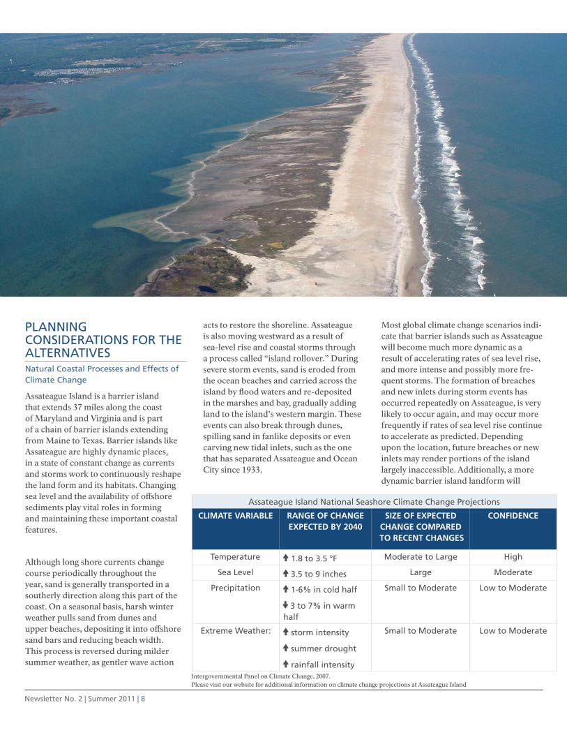
PlANNING coNSIDErAtIoNS for tHE AltErNAtIVESNatural coastal Processes and Effects of climate change
Assateague Island is a barrier island that extends 37 miles along the coast of Maryland and Virginia and is part of a chain of barrier islands extending from Maine to Texas. Barrier islands like Assateague are highly dynamic places, in a state of constant change as currents and storms work to continuously reshape the land form and its habitats. Changing sea level and the availability of offshore sediments play vital roles in forming and maintaining these important coastal features.
Although long shore currents change course periodically throughout the year, sand is generally transported in a southerly direction along this part of the coast. On a seasonal basis, harsh winter weather pulls sand from dunes and upper beaches, depositing it into offshore sand bars and reducing beach width. This process is reversed during milder summer weather, as gentler wave action
acts to restore the shoreline. Assateague is also moving westward as a result of sea-level rise and coastal storms through a process called “island rollover.” During severe storm events, sand is eroded from the ocean beaches and carried across the island by flood waters and re-deposited in the marshes and bay, gradually adding land to the island’s western margin. These events can also break through dunes, spilling sand in fanlike deposits or even carving new tidal inlets, such as the one that has separated Assateague and Ocean City since 1933.
Most global climate change scenarios indi-cate that barrier islands such as Assateague will become much more dynamic as a result of accelerating rates of sea level rise, and more intense and possibly more fre-quent storms. The formation of breaches and new inlets during storm events has occurred repeatedly on Assateague, is very likely to occur again, and may occur more frequently if rates of sea level rise continue to accelerate as predicted. Depending upon the location, future breaches or new inlets may render portions of the island largely inaccessible. Additionally, a more dynamic barrier island landform will
Assateague Island National Seashore climate change Projections
CLiMATE vARiABLE RAngE Of ChAngE ExPECTED By 2040
SizE Of ExPECTED ChAngE COMPARED
TO RECEnT ChAngES
COnfiDEnCE
temperature 5 1.8 to 3.5 °f Moderate to large High
Sea level 5 3.5 to 9 inches large Moderate
Precipitation 5 1-6% in cold half
% 3 to 7% in warm half
Small to Moderate low to Moderate
Extreme Weather: 5 storm intensity
5 summer drought
5 rainfall intensity
Small to Moderate low to Moderate
Intergovernmental Panel on Climate Change, 2007. Please visit our website for additional information on climate change projections at Assateague Island

Newsletter No. 2 | Summer 2011 | 9
challenge the ability of the NPS to provide recreational access and opportunities in traditional ways. Fixed infrastructure such as roads, parking lots and visitor use facili-ties will become increasingly more difficult and costly, if not impossible, to maintain.
While the pace and magnitude of climate change/sea level rise remains uncertain, it is clear that any plan for the future of the seashore must consider the management challenges associated with an increas-ingly dynamic island land form. Recent Department of the Interior and NPS policy calls for the incorporation of climate change consideration and response in all levels of planning. The NPS will continue to provide and protect visitor use and recreational opportunities on Assateague Island and seek new approaches to provid-ing sustainable access and infrastructure. Potential options, such as constructing roads and parking lots out of native materi-als, mobile facilities, relocation of infra-structure onto the adjacent mainland, and shuttle and ferry services to the island will need to be considered by future seashore managers, and are explored in the manage-ment alternatives.
Wilderness
The 1974 “Assateague Island Wilderness Study” and subsequent revisions deter-mined that 5,200 acres were suitable for federal wilderness designation pursuant to the Wilderness Act. 440 acres were recommended to Congress for immediate designation and the remaining 4,760 acres
were identified as “potential wilderness” to become eligible when non-conforming backcountry development and uses were eliminated. The NPS will continue to pro-tect and enhance the wilderness character of the proposed area, and would consider expansions to the area under two of the action alternatives.
Park Boundary
Federal law directs the NPS to evaluate the need to adjust a park’s boundary during a GMP. The NPS is in the process of determining whether an adjustment to the boundary is needed to accommodate the actions explored in the alternatives and help fulfill the purposes of the seashore.
cooperative Stewardship of chincoteague and Sinepuxent Bays and the Atlantic ocean
The estuarine and oceanic waters within the national seashore boundary are part of much larger water bodies and, therefore, reflect the prevailing conditions of the overall system. As such, the health of seashore waters and dependant aquatic systems are directly influenced by the conditions and land use activities occurring in the adjacent coastal bays watershed. Traditional agricultural practices and other land uses spurred by rapid population growth on the mainland are adversely impacting water quality in the coastal bays formed by Assateague Island and threaten the aquatic resources of the seashore. The NPS, Maryland Department of Natural Resources, U.S. Fish and Wildlife Service,
Maryland Coastal Bays Program, Worcester County, communities, and other entities will continue to work collaboratively to improve land use planning and regulations related to the management of the seashore and related areas.
Additional topics
There are numerous other issues, consid-erations, and decision points that apply to the seashore as a whole and that will be treated as being common to all alternatives in the GMP. Examples include questions like the appropriateness of establishing a clothing optional (nude) beach area as some have requested, or whether sika deer should be managed as a big game species for recreational opportunity or as a non-native invasive species to be controlled. Other issues where there is likely to be uniformity in response across all alternatives include management of the Assateague horse population, the degraded condition of regional air quality, and offshore energy development. These and other similar topics are beyond the scope of the alterna-tive summaries presented here and will be addressed more fully in the Draft GMP/EIS.
Newsletter No. 2 | Summer 2011 | 10
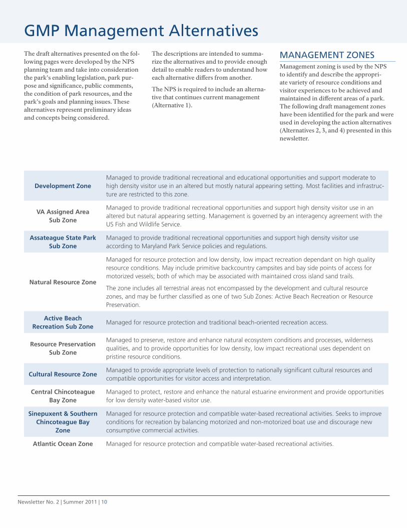
GMP Management AlternativesThe draft alternatives presented on the fol-lowing pages were developed by the NPS planning team and take into consideration the park’s enabling legislation, park pur-pose and significance, public comments, the condition of park resources, and the park’s goals and planning issues. These alternatives represent preliminary ideas and concepts being considered.
The descriptions are intended to summa-rize the alternatives and to provide enough detail to enable readers to understand how each alternative differs from another.
The NPS is required to include an alterna-tive that continues current management (Alternative 1).
MANAGEMENt ZoNES Management zoning is used by the NPS to identify and describe the appropri-ate variety of resource conditions and visitor experiences to be achieved and maintained in different areas of a park. The following draft management zones have been identified for the park and were used in developing the action alternatives (Alternatives 2, 3, and 4) presented in this newsletter.
Development zoneManaged to provide traditional recreational and educational opportunities and support moderate to high density visitor use in an altered but mostly natural appearing setting. Most facilities and infrastruc-ture are restricted to this zone.
vA Assigned Area Sub zone
Managed to provide traditional recreational opportunities and support high density visitor use in an altered but natural appearing setting. Management is governed by an interagency agreement with the US Fish and Wildlife Service.
Assateague State Park Sub zone
Managed to provide traditional recreational opportunities and support high density visitor use according to Maryland Park Service policies and regulations.
natural Resource zone
Managed for resource protection and low density, low impact recreation dependant on high quality resource conditions. May include primitive backcountry campsites and bay side points of access for motorized vessels; both of which may be associated with maintained cross island sand trails.
The zone includes all terrestrial areas not encompassed by the development and cultural resource zones, and may be further classified as one of two Sub Zones: Active Beach Recreation or Resource Preservation.
Active Beach Recreation Sub zone
Managed for resource protection and traditional beach-oriented recreation access.
Resource Preservation Sub zone
Managed to preserve, restore and enhance natural ecosystem conditions and processes, wilderness qualities, and to provide opportunities for low density, low impact recreational uses dependent on pristine resource conditions.
Cultural Resource zoneManaged to provide appropriate levels of protection to nationally significant cultural resources and compatible opportunities for visitor access and interpretation.
Central Chincoteague Bay zone
Managed to protect, restore and enhance the natural estuarine environment and provide opportunities for low density water-based visitor use.
Sinepuxent & Southern Chincoteague Bay
zone
Managed for resource protection and compatible water-based recreational activities. Seeks to improve conditions for recreation by balancing motorized and non-motorized boat use and discourage new consumptive commercial activities.
Atlantic Ocean zone Managed for resource protection and compatible water-based recreational activities.

Newsletter No. 2 | Summer 2011 | 11
Alternative 1coNtINuAtIoN of currENt MANAGEMENtThe NPS would continue to manage sea-shore resources and visitor use as it does today, with no major change in direction. The seashore’s enabling legislation, the existing General Management Plan (NPS 1982), and other implementation plans would continue to guide management decision-making. Decisions would be based on existing conditions and available information, but would continue to lack a comprehensive planning framework that addresses the full range of contemporary and potential future issues. Natural coastal processes would continue with minimal interference. Dune maintenance in the Maryland developed visitor area and other limited actions would protect facilities from storm damage, and visitor use facilities and infrastructure at risk of loss would be moved back from the shoreline. Improvements to visitor facilities and seashore operational facilities would include only projects that are already approved and fully funded, or compatible with the current direction of seashore management.
Visitor use and Experience - Existing in-terpretive, educational, and management programs providing a range of services to visitors would continue. The two visitor centers would continue to provide orienta-tion, information, interpretive programs, and exhibits and serve as both destination and points of departure for day visitors, bus tours, school groups, and campers. Traditional ranger-led activities and curriculum-based educational programs would continue to be available. Programs would continue to emphasize the primary interpretive themes, with climate change issues presented on a limited basis.
Visitors would continue to enjoy a variety of traditional beach-oriented recreational activities concentrated within the Maryland developed visitor area. The NPS would continue to support beach-oriented recreational activities in the Virginia developed visitor area through its agreement with the U.S. Fish and Wildlife
Service. The availability of recreation opportunities may change as natural coastal processes and the effects of climate change/sea level rise continue to re-shape the island and damage facilities; limited actions would be taken to reclaim lost land area, to replace facilities, or to further protect recreational resources.
Opportunities for driving on the beach in Maryland would continue within the seashore’s existing designated OSV zone with minimal or no management changes. The seashore’s public hunting program would continue to be managed for its recreational values and as a resource management tool to control non-native species.
Seashore facilities and operations in Maryland - Existing visitor facilities and infrastructure would continue to have varying degrees of sustainability. Decisions regarding the repair and/or replacement of damaged facilities and infrastructure would generally be based on available funding. To the extent possible they would be repaired or replaced at or near their current locations. Existing facility management, law enforcement, visitor service, administrative, and resource protection operations would continue largely unchanged.
Natural resource Management - Existing natural resource management programs would continue, many in partnership with federal, state, and local agencies, aca-demic institutions, and non-governmental organizations. Programs would focus on protecting sensitive species, monitoring resource conditions, mitigating external threats, controlling non-native species, and restoring habitats impacted by man-made structures or activities. The feral horse population would continue to be actively managed with contraceptives to achieve and maintain a stable population of 80 to 100 horses. Continued coopera-tive research directed toward manage-ment issues would provide improved understanding of seashore resources and ecological processes.
Certain types of unauthorized commercial fishing would continue to occur within the seashore. Leasing of submerged lands by the state of Virginia within the seashore boundary for commercial aquaculture would continue, and likely expand in extent. The NPS would continue to dis-courage the state of Maryland from leasing submerged lands within the seashore boundary. There would be no action related to privately owned structures associated with submerged land leases in Chincoteague Bay within the seashore boundary.
Wilderness - the NPS would continue to protect and enhance the wilderness character of the proposed area through actions to eliminate incompatible features and activities. There would be no change in the size or location of the proposed wilderness.
cultural resource Management - Existing programs providing basic protection to the seashore’s cultural resources would continue consistent with applicable fed-eral and state laws and regulations, NPS policies, and adopted NPS plans for the seashore. The former Assateague Beach Coast Guard Station would continue to be maintained subject to the availability of funding.
Partnerships - Existing partnerships and cooperative relationships that support ongoing management would continue. Key partners would be Assateague State Park and Chincoteague National Wildlife Refuge.
land Acquisition – The NPS is currently seeking an easement from the state of Maryland for the use of state-owned lands adjacent to the NPS headquarters complex for the upland disposal of treated wastewater from its existing wastewater treatment plant. No land acquisition is currently planned.
Newsletter No. 2 | Summer 2011 | 12
Alternative 2
coNcENtrAtED trADItIoNAl BEAcH rEcrEAtIoNMost visitors to the seashore would enjoy traditional beach recreation concentrated within a high density developed visitor area accessible by private vehicle. Artificial dune fortification, habitat manipulations, and possibly beach nourishment would be used to protect the Maryland developed visitor area from the effects of natural coastal processes and climate change/sea level rise as long as a suitable land base exists and funding is available. Over time, the Maryland developed visitor area would likely be consolidated in response to the increasing challenge of protecting facilities from sea level rise and greater storm intensity. Increased crowding could lead to visitor use limits and increased fees could be needed to offset the higher cost of provid-ing visitor facilities. Storm overwash and breaches in the Maryland developed visi-tor area would be repaired, while natural evolution of the island’s backcountry areas would continue without interference and would be subject to the full effects of natural coastal processes and climate change/sea level rise.
Visitor use and Experience - The sea-shore’s two visitor centers would continue to provide orientation, information, inter-pretive programs, and exhibits and would serve as both destination and departure points for day visitors, bus tours, school groups, and campers. Interpretive and environmental education programming would be based on the primary interpre-tive themes but would increasingly focus on recreation, orientation, information, and safety.
The NPS would continue to support beach oriented recreational activities in the Virginia developed visitor area through its agreement with the U.S. Fish and Wildlife Service.
Traditional recreational uses and activities in the Maryland developed visitor area would be maintained on the island as long
as suitable land base exists and funding is available. Expanded commercial services, additional lifeguards, and campground facilities with more amenities would enhance the visitor experience in the de-veloped visitor area. Current recreational uses in the backcountry and in adjacent waters would continue but with minimal additional investment in facilities to sup-port those uses. High density visitor use at the north tip of the island would not be allowed. Public hunting would continue as currently managed.
As long as access exists, opportunities for driving on the beach in Maryland would continue but within a smaller designated OSV zone limited to the area outside of the proposed wilderness (south of developed visitor area to approximately KM 23.4). If vehicular access to the OSV zone is lost due to natural coastal processes or the effects of climate change and sea level rise, no action would be taken to restore it and access could be further reduced or eliminated.
The risk to continued visitor use and enjoyment of the seashore under this alternative would be high. Should fortifi-cation of the Maryland developed visitor area ultimately prove impracticable and/or should funding not be available to repair damaged or lost facilities, the seashore could become inaccessible to visitors for months to years following major storm events.
Seashore facilities and operations in Maryland - Over time visitor facilities and infrastructure such as developed campgrounds, beach parking, restrooms, and changing areas would be concentrated within a smaller developed area and forti-fied to withstand the impacts of natural coastal processes and climate change/sea level rise. New facilities may be developed to enhance recreational opportunities, such as a campground store or restaurant. Beach parking, RV camping, and other improvements would continue to be acces-sible via private vehicle. A mainland-based commercial shuttle would provide access once island parking capacity is reached.
Most administrative and maintenance functions would be based in rehabilitated facilities in their current location at the Maryland headquarters complex. The NPS would seek to acquire property in the general vicinity of the headquarters complex for use for alternative transporta-tion parking. A combined ranger station/campground office and small maintenance yard would remain on the island.
Natural resource Management - Programs and actions to protect and man-age the seashore’s most significant natural resources would continue. The primary emphasis of resource management actions would remain directed towards protecting sensitive species, monitoring resource conditions, mitigating external threats, and controlling invasive plant and animal species. Over time, some resource man-agement programs and activities would likely diminish as funding and staffing are re-directed towards the protection of recreational opportunities and visitor use management.
The NPS would initiate a regulatory process to authorize certain types of cur-rently unauthorized commercial fishing within the park boundary in recognition of its historic occurrence. Leasing of submerged lands by the state of Virginia within the park boundary for commercial aquaculture would continue, and likely expand in extent. The NPS would neither encourage nor discourage the state of Maryland from leasing submerged lands within the park boundary for com-mercial aquaculture. The authority for privately owned structures associated with submerged land leases in Chincoteague Bay within the park boundary would be assessed and action taken to regulate waterwater treatment and disposal.
Wilderness - the NPS would continue to protect and enhance the wilderness character of the proposed area through actions to eliminate incompatible features and activities. There would be no change in the size or location of the proposed wilderness.

MARYLAND
VIRGINIA
Assateague Channel Bridge
Minor expansion of seashore headquarters anticipated to support alternative transportation systems
611
175
Swan
s Cov
e Trai
l
Over-
Sand
Vehic
le Ro
ute
Beach Road
Woodland Trail
Wildlife Loop
Back
coun
try R
oad
Servi
ce R
oad
Service Road
Service
Road
Over-
Sand
Vehic
le Ro
ute
“Bull Pen”
Service Road
B-22
B-21
A-23
B-25
A-20
B-10
A-18
B-14
A-17
B-12
B-11
Bayb
erry D
rive
Over
-San
d Ve
hicle
Rou
te
Assateague State Park
Oceanside Campground
Tingles Campsite
Bayside Campground
Little Levels Campsite
Pine Tree Campsite
Pope Bay CampsiteState Line Campsite
Chincoteague National Wildlife Refuge
Toms Cove Recreational Beach
Assateague Beach Coast Guard Station
SeashoreHeadquarters
cultural resource Management - Management actions including artificial dune fortification and habitat manipula-tion would be used to protect the former Assateague Beach Coast Guard Station. Other cultural resources would be protected from the impacts of human activities; however, they would not be protected from the effects of coastal processes and climate change/sea level rise, although some effort would be made to document known resources at risk of loss. Former residences and hunting camps in Maryland would be removed from the backcountry to restore the natural environment.
Partnerships - Existing partnerships and cooperative relationships that support seashore management would continue. As actions to fortify and protect the pri-mary developed visitor area in Maryland become more complex, the NPS would expand its existing partnership with the U.S. Army Corps of Engineers related to erosion control. Partnerships with tourism and recreation interests would likely expand, particularly those with new commercial service providers active in the Maryland developed visitor area.
land Acquisition – In addition to the ease-ment acquisition described in Alternative 1, the NPS would seek to acquire a parcel of land in the general vicinity of the Maryland headquarters complex to support the development of an alternative transportation shuttle system.
Development Zone and Sub ZonesDevelopment ZoneAssateague State Park Sub ZoneVirginia Assigned Area Sub Zone
Natural Resource Zone and Sub ZonesNatural Resource ZoneActive Beach Recreation Sub Zone (including OSV Area)Resource Preservation Sub Zone
Cultural Resource ZoneCultural Resource Zone
Bay ZonesSinepuxent Bay and Southern Chincoteague Bay ZoneCentral Chincoteague Bay Zone
Ocean ZoneAtlantic Ocean Zone
Chincoteague National Wildlife RefugeChincoteague National Wildlife Refuge
A L T E R N A T I V E 2 M A N A G E M E N T Z O N E S
Development Zone and Sub ZonesDevelopment ZoneSustainable Development ZoneAssateague State Park Sub ZoneVirginia Assigned Area Sub Zone
Natural Resource Zone and Sub ZonesNatural Resource ZoneActive Beach Recreation Sub Zone (including OSV Area)Resource Preservation Sub Zone
Cultural Resource ZoneCultural Resource Zone
Bay ZonesSinepuxent Bay and Southern Chincoteague Bay ZoneCentral Chincoteague Bay ZoneMarine Research Reserve Sub Zone
Ocean ZoneAtlantic Ocean Zone
Chincoteague National Wildlife RefugeChincoteague National Wildlife Refuge
A L T E R N A T I V E 3M A N A G E M E N T Z O N E S
(see note on map)
Development Zone and Sub ZonesDevelopment ZoneAssateague State Park Sub ZoneVirginia Assigned Area Sub Zone
Natural Resource Zone and Sub ZonesNatural Resource ZoneActive Beach Recreation Sub Zone (including OSV Area)Resource Preservation Sub Zone
Cultural Resource ZoneCultural Resource Zone
Bay ZonesSinepuxent Bay and Southern Chincoteague Bay ZoneCentral Chincoteague Bay Zone
Ocean ZoneAtlantic Ocean Zone
Chincoteague National Wildlife RefugeChincoteague National Wildlife Refuge
A L T E R N A T I V E 2 M A N A G E M E N T Z O N E S
Development Zone and Sub ZonesDevelopment ZoneSustainable Development ZoneAssateague State Park Sub ZoneVirginia Assigned Area Sub Zone
Natural Resource Zone and Sub ZonesNatural Resource ZoneActive Beach Recreation Sub Zone (including OSV Area)Resource Preservation Sub Zone
Cultural Resource ZoneCultural Resource Zone
Bay ZonesSinepuxent Bay and Southern Chincoteague Bay ZoneCentral Chincoteague Bay Zone
Ocean ZoneAtlantic Ocean Zone
Chincoteague National Wildlife RefugeChincoteague National Wildlife Refuge
A L T E R N A T I V E 4M A N A G E M E N T Z O N E S
°0 1.0 1.5 2.0 2.5 3.0 4.0 5.00.5Miles N
OSV use would occur within the Active Beach Recreation Sub Zone, as illustrated on this map.
In Alternative 2, the area open to OSV use would be smaller than it is today. Portions of the beach within the proposed and recommended wildernessareas (except for the Fox Hills bayside access sand road) would no longer be open to OSV use.
In the future, coastal storms or other natural processes could create breaches/inlets that would cut-off access to all or part of the Active Beach Recreation Sub Zone. If and when this happens, the inaccessible areas would be permanently closed to OSV use.
Oversand Vehicle (OSV) Use•
•
•
Newsletter No. 2 | Summer 2011 | 14
Alternative 3
SuStAINABlE rEcrEAtIoN AND clIMAtE cHANGE ADAPtAtIoN Climate change adaptation would play an increasingly important role in seashore management. Over time, the effects of nat-ural coastal processes and climate change/sea level rise are expected to become the dominant force shaping the character of the Maryland developed visitor area. To minimize or avoid the damaging effects of natural coastal processes and climate change/sea level rise, visitor use infrastruc-ture would evolve to more sustainable designs and likely shift to new, more stable locations. Some manipulations of the natural environment would be necessary to sustain recreation opportunities but would be minor. Future breaches or other island changes throughout the Maryland portion of the seashore would be allowed to evolve naturally. Planning and develop-ment of alternative transportation systems including shuttles, ferries, and new bayside access along Chincoteague Bay would prepare the seashore for possible loss of traditional land access. Overall, visitors would enjoy expanded opportuni-ties for sustainable recreation throughout the seashore.
Visitor use and Experience - The sea-shore’s two visitor centers would continue to provide orientation and information but would increasingly become centers of learning emphasizing resource steward-ship, sustainability, climate change threats and adaptation, and seashore resource management issues. Traditional ranger led programs and environmental education would be guided by the primary interpre-tive themes as well as the special emphasis issues, and would continue to stress activities and experiences that promote resource stewardship and opportunities for in-depth learning. As new points of departure are developed (ferry terminal, shuttle staging areas, Chincoteague Bay) these areas would provide new opportuni-ties for visitor contact, orientation, safety messaging, and seashore information.
The NPS would continue to support beach oriented recreational activities in the Virginia developed visitor area through its agreement with the U.S. Fish and Wildlife Service.
Most recreational uses and activities in the Maryland portion of the seashore would be maintained on the island although, over time, the facilities and infrastructure supporting those uses would evolve towards greater sustainability. Some recre-ational activities, such as RV camping, may eventually be relocated to the mainland. New bayside access points would provide expanded opportunities for sustainable recreation in the backcountry. Public hunting would continue as currently managed although if land-based access to the backcountry is altered due to coastal processes or the effects of climate change/sea level rise, hunting access to some por-tions of the seashore may become more difficult.
Opportunities for driving on the beach in Maryland would continue within the seashore’s existing OSV zone until condi-tions change. OSV use would be managed for maximum flexibility to respond to changing conditions, protect sensitive resources, and minimize conflicts with other seashore uses. If vehicular access to the OSV zone is lost due to natural coastal processes or the effects of climate change and sea level rise, consideration would be given to modifying the route or relocating it to another more suitable location.
The risk to continued visitor use at the seashore would be low under this alternative. Adaptive management and contingency planning – including develop-ment of alternative means of accessing the island – would reduce the potential for the seashore to become inaccessible to visitors following major storm events.
Seashore facilities and operations in Maryland - Over time visitor use facilities
and infrastructure would evolve in design and may shift to new, more sustainable lo-cations on the island. For example, some or all of the Oceanside RV campground may be moved to the more stable bayside causeway area. Initially beach parking, RV camping, and other improvements would continue to be accessible by private vehicle.
When no longer sustainable on the island, some facilities and infrastructure would move to the mainland. A mainland-based commercial shuttle would provide access once parking capacity is reached. More visitors would access the island by water, using a network of new public access sites on the mainland and along the length of the seashore’s bay side. Should the bridge to the Maryland portion of the island be damaged or fail or if there was a breach that prevented use of private vehicles, access to the island would shift to a fully water-based system composed of a new passenger ferry and the network of new public access sites.
Most administrative and maintenance functions would be relocated to another mainland location to allow development of a shuttle/ferry parking facility at the current headquarters site. A combined ranger station/campground office would remain on the island, although it would be replaced with a moveable facility once the existing permanent structure is no longer sustainable.
Natural resource Management - Natural resource protection programs would expand and the scope of some existing programs would change to address the increasingly complex resource manage-ment issues created by global climate change/sea level rise. Programs would focus on enhancing the resiliency of resources vulnerable to climate change effects, monitoring key climate drivers and resource conditions, and improving the sustainability of visitor use and seashore operations. Cooperative research would

MARYLAND
VIRGINIA
Up to one to three new bayside access points,future sites to be determined
Possible location for a potential new boat-in campsite in VA
Marine Research Reserve to be located within a portion of the Central Chincoteague Bay Zone – size, location, and duration of the sub zone to be determined at a later date in consultation with the states
Major expansion of seashore headquarters area anticipated to support seashore operations - specific location to be determine and the relocation of some island infrastructured
Assateague Channel Bridge
North Tip Boat-in Beach
611
175
Swan
s Cov
e Trai
l
Over-
Sand
Vehic
le Ro
ute
Beach Road
Woodland Trail
Wildlife Loop
Back
coun
try R
oad
Servi
ce R
oad
Service Road
Service
Road
Over-
Sand
Vehic
le Ro
ute
“Bull Pen”
Service Road
B-22
B-21
A-23
B-25
A-20
B-10
A-18
B-14
A-17
B-12
B-11
Bayb
erry D
rive
Over
-San
d Ve
hicle
Rou
te
Assateague State Park
Oceanside Campground
Tingles Campsite
Bayside Campground
Little Levels Campsite
Pine Tree Campsite
Pope Bay CampsiteState Line Campsite
Chincoteague National Wildlife Refuge
Toms Cove Recreational Beach
Assateague Beach Coast Guard Station
SeashoreHeadquarters
Development Zone and Sub ZonesDevelopment ZoneAssateague State Park Sub ZoneVirginia Assigned Area Sub Zone
Natural Resource Zone and Sub ZonesNatural Resource ZoneActive Beach Recreation Sub Zone (including OSV Area)Resource Preservation Sub Zone
Cultural Resource ZoneCultural Resource Zone
Bay ZonesSinepuxent Bay and Southern Chincoteague Bay ZoneCentral Chincoteague Bay Zone
Ocean ZoneAtlantic Ocean Zone
Chincoteague National Wildlife RefugeChincoteague National Wildlife Refuge
A L T E R N A T I V E 3M A N A G E M E N T Z O N E S
Development Zone and Sub ZonesDevelopment ZoneSustainable Development ZoneAssateague State Park Sub ZoneVirginia Assigned Area Sub Zone
Natural Resource Zone and Sub ZonesNatural Resource ZoneActive Beach Recreation Sub Zone (including OSV Area)Resource Preservation Sub Zone
Cultural Resource ZoneCultural Resource Zone
Bay ZonesSinepuxent Bay and Southern Chincoteague Bay ZoneCentral Chincoteague Bay ZoneMarine Research Reserve Sub Zone
Ocean ZoneAtlantic Ocean Zone
Chincoteague National Wildlife RefugeChincoteague National Wildlife Refuge
A L T E R N A T I V E 3M A N A G E M E N T Z O N E S
(see note on map)
Development Zone and Sub ZonesDevelopment ZoneAssateague State Park Sub ZoneVirginia Assigned Area Sub Zone
Natural Resource Zone and Sub ZonesNatural Resource ZoneActive Beach Recreation Sub Zone (including OSV Area)Resource Preservation Sub Zone
Cultural Resource ZoneCultural Resource Zone
Bay ZonesSinepuxent Bay and Southern Chincoteague Bay ZoneCentral Chincoteague Bay Zone
Ocean ZoneAtlantic Ocean Zone
Chincoteague National Wildlife RefugeChincoteague National Wildlife Refuge
A L T E R N A T I V E 2 M A N A G E M E N T Z O N E S
Development Zone and Sub ZonesDevelopment ZoneSustainable Development ZoneAssateague State Park Sub ZoneVirginia Assigned Area Sub Zone
Natural Resource Zone and Sub ZonesNatural Resource ZoneActive Beach Recreation Sub Zone (including OSV Area)Resource Preservation Sub Zone
Cultural Resource ZoneCultural Resource Zone
Bay ZonesSinepuxent Bay and Southern Chincoteague Bay ZoneCentral Chincoteague Bay Zone
Ocean ZoneAtlantic Ocean Zone
Chincoteague National Wildlife RefugeChincoteague National Wildlife Refuge
A L T E R N A T I V E 4M A N A G E M E N T Z O N E S
°0 1.0 1.5 2.0 2.5 3.0 4.0 5.00.5Miles N
OSV use would occur within the Active Beach Recreation Sub Zone, as illustrated on this map.
In Alternative 3, the area open to OSV use would remain until conditions change.
In the future, coastal storms or other natural processes could create breaches/inlets that would cut-off access to all or part of the Active Beach Recreation Sub Zone. If and when this happens, the inaccessible areas would be closed to OSV use. At that time, the NPS would consider replacing all or a portion of the area lost to OSV use by opening other portions of the island to oversand vehicles.
Oversand Vehicle (OSV) Use•
•
•

Newsletter No. 2 | Summer 2011 | 16
expand, accelerating growth in the understanding of seashore resources and ecological processes. Creation of a marine research reserve in central Chincoteague Bay would stimulate cooperative research into the effects of global climate change on estuarine systems and the effects of human activities – both water-based and land-based – on water quality and aquatic resources.
Within its legal authorities, the NPS would seek a permanent ban on the leasing of submerged lands for commercial aquacul-ture in Maryland, and encourage the state of Virginia to designate certain submerged lands with high resource sensitivity and/or recreational value within the seashore boundary as public oyster grounds.Unauthorized commercial horseshoe crab harvest would be prohibited. The NPS would initiate a review and assess-ment of other currently unauthorized commercial fishing activities to determine the appropriate regulatory mechanism. Unauthorized privately owned structures associated with submerged land leases in Chincoteague Bay within the park boundary would be removed. Authorized structures would be managed to ensure compliance with applicable wastewater disposal regulations.
Wilderness - The proposed wilderness area would be expanded to include most of the island south of approximately KM 21.5 to the MD/VA state line except that OSV use would continue to be allowed on the ocean beach below the winter storm
berm and on the two existing cross-island bay access sand roads. Management of the expanded area would emphasize the protection and enhancement of wilder-ness characteristics through actions to eliminate incompatible features such as structures, drainage ditches, and former roads.
cultural resource Management - National Register-eligible resources (e.g., Assateague Beach Coast Guard Station and potentially one or more of the former hunting camps in Maryland) would be protected and maintained in situ as long as possible using accepted practices, including adaptive re-use. If threatened by coastal processes or the effects of climate change and sea level rise, mitigation options would include minor manipulation of the natural environment and potentially moving structures to more stable locations either on or off the island. Other cultural resources would be identified and – if determined to be at risk – documented prior to loss; other mitigation needs would be evaluated on a case-by-case basis. Most of the former residences and hunting camps in Maryland would be removed from the island to restore natural conditions.
Partnerships - Existing partnerships and cooperative relationships that support ongoing management would continue. Partnerships would likely expand with Assateague State Park and Chincoteague National Wildlife Refuge as cooperative solutions are developed to address the
effects of coastal processes and climate change/sea level rise. Partnership activity with the scientific and educational com-munities would expand with efforts to enhance resource resiliency and climate change adaptation. Establishment of a marine research reserve would require and stimulate new partnerships with aca-demia, and with federal and state fisheries management and marine enforcement agencies. If recreational amenities move from the island to the Maryland main-land, new partnerships with Worcester County and adjacent landowners would be required. Relationships with commer-cial service providers would also expand with new alternative transportation systems and efforts to improve accessibil-ity to the backcountry.
land Acquisition – In addition to the easement acquisition described in Alternative 1, the NPS would seek to acquire land in the general vicinity of the Maryland headquarters complex sufficient to support the relocation of administrative and maintenance facilities in order to use the existing land base for the development of alternative transpor-tation systems. These new lands may also be used to support the relocation of some island facilities and infrastructure should the need arise. Additionally, the NPS would seek to acquire various types of legal interest in lands within the Chincoteague Bay watershed for conservation purposes and to support the development of points of departure for island access.

Newsletter No. 2 | Summer 2011 | 17
Alternative 4
NAturAl ISlAND EVolutIoN AND A PrIMItIVE ISlAND ExPErIENcE Natural evolution of the island would occur without interference and subject to the full effects of natural coastal processes and climate change/sea level rise. Future breaches or other island changes through-out the Maryland portion of the seashore would be allowed to evolve naturally. Existing visitor use facilities and infra-structure would remain in the Maryland developed visitor area until such time as they are lost and/or damaged by coastal processes or become obsolete. In re-sponse to the threat from climate change/sea level rise, minimal future investments would be made on the Maryland portion of the island, limited to the development and maintenance of sustainable, low impact day use facilities and primitive camping infrastructure. Over time visitor use would shift to primarily day use activities in a more primitive island setting. More emphasis would be placed on the role of the seashore as a protected natural environment and living laboratory for scientific research and study.
Visitor use and Experience - The sea-shore’s two visitor centers would continue to provide orientation, information, interpretive programs, and exhibits. Traditional ranger-led activities and curriculum-based environmental educa-tion programs would also continue, but the location of activities in the Maryland portion of the seashore would gradu-ally shift away from the island as access becomes less automobile based. While the primary interpretive themes would continue to provide a basic foundation for programming, increasing emphasis would be placed on issues related to climate change and the role of the seashore as a protected natural environment and living laboratory.
The NPS would continue to support beach oriented recreational activities in the Virginia developed visitor area through its agreement with the U.S. Fish and Wildlife Service.
Over time visitor use in the Maryland portion of the seashore would transition to become almost exclusively day-use, with the experience becomingly increas-ingly primitive. Some existing recreational opportunities, such as developed area RV camping, would eventually be phased out. Public hunting would continue as currently managed although if land-based access to the backcountry is altered due to coastal processes or the effects of climate change/sea level rise, hunting access to some portions of the seashore may become more difficult.
Opportunities for driving on the Maryland beach would continue within the seashore’s existing OSV zone. As with Alternative 2, if vehicular access to the OSV zone is lost due to natural coastal processes or the effects of climate change and sea level rise, no action would be taken to restore it and access could be reduced or eliminated.
The risk to continued visitor use at the seashore would be low to moderate under this alternative. Contingency planning – including development of alternative means of accessing the island – would reduce the potential for the seashore to become inaccessible to visitors following major storm events.
Seashore facilities and operations in Maryland - Over time visitor use facilities and infrastructure would remain until they are lost or damaged by coastal processes or the effects of climate change and sea level rise. Ultimately visitor use facilities would support only day use recreation. If existing roadways and parking facilities are lost or damaged, they would not be
repaired, replaced, or relocated. Instead a mainland-based commercial shuttle would provide access. Should the bridges to the island be damaged or fail, access to the island would shift to a fully water-based system composed of a new passenger ferry and water-based access offered by commercial service providers operating from existing public access sites on the mainland.
Most administrative and maintenance functions would be relocated to another mainland location to allow development of a shuttle/ferry parking facility at the current site. A combined ranger station/campground office would remain on the island, although it would be replaced with a smaller moveable facility once the existing permanent structure is no longer sustainable.
Natural resource Management -Natural resource protection programs would expand as the seashore emphasizes resource preservation and its role as a natural laboratory for scientific research and study. New programs would focus on mitigating human impacts and climate change adaptation, including actions to enhance the resiliency of vulnerable resources, monitoring key climate drivers and resource conditions, and enhancing the sustainability of seashore operations. Cooperative research would expand to include a broader agenda of basic science and research into barrier island ecology and the effects of climate change/sea level rise on coastal ecosystems.
Within its legal authorities, the NPS would seek a permanent ban on the leasing of submerged lands for commercial aqua-culture in Maryland and encourage the state of Virginia to designate all currently un-leased submerged lands within the park boundary as public oyster grounds. All unauthorized commercial fishing, including horseshoe crab harvest, would be prohibited. Unauthorized privately
Newsletter No. 2 | Summer 2011 | 18
owned structures associated with sub-merged land leases in Chincoteague Bay within the park boundary would be removed. Authorized structures would be managed to ensure compliance with ap-plicable wastewater disposal regulations.
Wilderness - The proposed wilderness area would be expanded significantly to include most of the island south of the de-veloped visitor use area, except that public OSV use would continue to be allowed on the ocean beach below the winter storm berm and on the two existing cross-island bay access sand roads. Management of the expanded area would emphasize the protection and enhancement of wilder-ness characteristics through actions to eliminate incompatible features such as structures, drainage ditches, and former roads.
cultural resource Management - Known cultural resources including the Assateague Beach Coast Guard Station would be maintained until such time as they are damaged or lost due to coastal processes or the effects of climate change and sea level rise. No action would be taken to prevent impacts, or to repair or restore damaged resources. Some effort would be made to document resources prior to loss.
Restoration of the backcountry natural environment would require removal of former residences and hunting camps in Maryland.
Partnerships - Existing partnerships and cooperative relationships that support ongoing management would continue. Partnership activity with the academic and educational communities would expand with efforts to stimulate scientific
research and utilize the seashore as a natural laboratory. The prohibition of commercial fishing would require expanded partnerships with federal and state marine enforcement agencies. As traditional means of access are lost and alternative transportation systems are introduced, partnerships with commer-cial service providers would expand.
land Acquisition – In addition to the easement acquisition described in Alternative 1, the NPS would seek to acquire land in the general vicinity of the Maryland headquarters complex sufficient to support the relocation of ad-ministrative and maintenance facilities in order to use the existing land base for the development of alternative transportation systems. Additionally, the NPS would seek to acquire various types of legal interest in lands within the Chincoteague Bay watershed for conservation purposes.
MARYLAND
VIRGINIA
Assateague Channel Bridge
Minor expansion of seashore headquarters area anticipated to support seashore operations - specific location to be determined
North Tip Boat-in Beach
611
175
Swan
s Cov
e Trai
l
Over-
Sand
Vehic
le Ro
ute
Beach Road
Woodland Trail
Wildlife Loop
Back
coun
try R
oad
Servi
ce R
oad
Service Road
Service
Road
Over-
Sand
Vehic
le Ro
ute
“Bull Pen”
Service Road
B-22
B-21
A-23
B-25
A-20
B-10
A-18
B-14
A-17
B-12
B-11
Bayb
erry D
rive
Over
-San
d Ve
hicle
Rou
te
Assateague State Park
Oceanside Campground
Tingles Campsite
Bayside Campground
Little Levels Campsite
Pine Tree Campsite
Pope Bay CampsiteState Line Campsite
Chincoteague National Wildlife Refuge
Toms Cove Recreational Beach
Assateague Beach Coast Guard Station
SeashoreHeadquarters
Development Zone and Sub ZonesDevelopment ZoneAssateague State Park Sub ZoneVirginia Assigned Area Sub Zone
Natural Resource Zone and Sub ZonesNatural Resource ZoneActive Beach Recreation Sub Zone (including OSV Area)Resource Preservation Sub Zone
Cultural Resource ZoneCultural Resource Zone
Bay ZonesSinepuxent Bay and Southern Chincoteague Bay ZoneCentral Chincoteague Bay Zone
Ocean ZoneAtlantic Ocean Zone
Chincoteague National Wildlife RefugeChincoteague National Wildlife Refuge
A L T E R N A T I V E 4M A N A G E M E N T Z O N E S
Development Zone and Sub ZonesDevelopment ZoneSustainable Development ZoneAssateague State Park Sub ZoneVirginia Assigned Area Sub Zone
Natural Resource Zone and Sub ZonesNatural Resource ZoneActive Beach Recreation Sub Zone (including OSV Area)Resource Preservation Sub Zone
Cultural Resource ZoneCultural Resource Zone
Bay ZonesSinepuxent Bay and Southern Chincoteague Bay ZoneCentral Chincoteague Bay ZoneMarine Research Reserve Sub Zone
Ocean ZoneAtlantic Ocean Zone
Chincoteague National Wildlife RefugeChincoteague National Wildlife Refuge
A L T E R N A T I V E 3M A N A G E M E N T Z O N E S
(see note on map)
Development Zone and Sub ZonesDevelopment ZoneAssateague State Park Sub ZoneVirginia Assigned Area Sub Zone
Natural Resource Zone and Sub ZonesNatural Resource ZoneActive Beach Recreation Sub Zone (including OSV Area)Resource Preservation Sub Zone
Cultural Resource ZoneCultural Resource Zone
Bay ZonesSinepuxent Bay and Southern Chincoteague Bay ZoneCentral Chincoteague Bay Zone
Ocean ZoneAtlantic Ocean Zone
Chincoteague National Wildlife RefugeChincoteague National Wildlife Refuge
A L T E R N A T I V E 2 M A N A G E M E N T Z O N E S
Development Zone and Sub ZonesDevelopment ZoneSustainable Development ZoneAssateague State Park Sub ZoneVirginia Assigned Area Sub Zone
Natural Resource Zone and Sub ZonesNatural Resource ZoneActive Beach Recreation Sub Zone (including OSV Area)Resource Preservation Sub Zone
Cultural Resource ZoneCultural Resource Zone
Bay ZonesSinepuxent Bay and Southern Chincoteague Bay ZoneCentral Chincoteague Bay Zone
Ocean ZoneAtlantic Ocean Zone
Chincoteague National Wildlife RefugeChincoteague National Wildlife Refuge
A L T E R N A T I V E 4M A N A G E M E N T Z O N E S
°0 1.0 1.5 2.0 2.5 3.0 4.0 5.00.5Miles N
OSV use would occur within the Active Beach Recreation Sub Zone, as illustrated on this map.
In Alternative 4, the area open to OSV use would remain until conditions change.
In the future, coastal storms or other natural processes could create breaches/inlets that would cut-off access to all or part of the Active Beach Recreation Sub Zone. If and when this happens, the inaccessible areas would be permanently closed to OSV use.
Oversand Vehicle (OSV) Use•
•
•
National Park ServiceU.S. Department of the Interior
Assateague Island National Seashore 7206 National Seashore Lane Berlin, MD 21811
This newsletter is a publication of the National Park Service,
Assateague Island National Seashore. For additional informa-
tion, please contact Superintendent, Assateague Island National
Seashore, 7206 National Seashore Lane, Berlin, MD 21811 or
call (410) 629-6061.
Visit us on the web at www.nps.gov/asis
gEnERAL TiME fRAME
PLAnning PhASE hOW yOu CAn BE invOLvED
Summer 2009 Scoping
review Newsletter 1
Participate in public open houses
Send us your ideas and comments
Summer 2011
Develop and Present
Preliminary Alternatives
review Newsletter 2
Participate in public open houses
Send us your ideas and comments
fall 2011Prepare and Distribute
a Draft GMP
review Draft GMP
Participate in public open houses
Send us your ideas and comments
Summer 2012revise Draft Plan and Prepare a final GMP
review final GMP
fall 2012 ImplementationWork with the seashore to imple-ment the GMP, as funding allows
ASSAtEAGuE ISlAND NAtIoNAl SEASHorE GMP ScHEDulE
StAYING INVolVED WItH tHE GMPYour input is critical throughout the process. Your comments and suggestions will assist the NPS in the process of refining the alternatives for presentation in a formal draft general management plan and environmen-tal impact statement. We are interested in learning about the ideas you support and those with which you have concerns, and why.
We look forward to hearing from you about the information presented in this newsletter. Suggestions and comments can be provided in any one of the following ways:
•�Drop�by�at�one�of�our�open�house�work-shops. Talk with planning team members and fill out a comment form.
•��Go�on-line�to�the�park’s�website�at�www.nps.gov/asis or the NPS planning website at http://parkplanning.nps.gov/asis and fill out a comment form.
•��Call�the�national�seashore�at�410-629-6061�and request a comment form that can be mailed or faxed back.