microfacies analysis and depositional environment of...
TRANSCRIPT
DonnishJournals 2041-3863
Corresponding Author: [email protected]
Donnish Journal of Geology And Mining Research Vol 1(1) pp. 001-026 March, 2015 http://www.donnishjournals.org/djgmr Copyright © 2015 Donnish Journals
Original Research Article
Microfacies Analysis and Depositional Environment of the Sargelu Formation (Middle Jurassic) from Kurdistan Region, Northern Iraq
Rzger A. Abdula, Sardar M. Balaky, Mohammad Sadi Nourmohamadi and Muhamad Piroui
Department of Petroleum Geosciences, Soran University, Soran, Kurdistan Region, Iraq
Accepted 26th February, 2015.
The depositional sedimentary environment and petrology of the Sargelu Formation (of Late Toarcian–Late Bathonian
age) is presented based on hand specimen descriptions, petrographic thin sections, and scanning electron microscope
(SEM). This study examined certain outcrops from various areas in Iraqi Kurdistan in order to build on the earlier work
and add new explanations. The formation is mainly composed of limestone with shale. The limestone is medium to thick
bedded, calcareous or marly and bituminous with interbeds of dolomitic limestone and chert appears on the upper part
of the formation. Three main microfacies types have been recognized within Sargelu Formation. They are lime mudstone,
wackestone, and packstone. The occurrence and distribution of microfacies indicate that the position in overall is marine
basin represent deeper ramp. On the basis of these three microfacies and a lithofacies, the Sargelu Formation is
interpreted to represent deposition on the ramp. The organic-rich sediments of Sargelu Formation indicate an euxinic
(anoxic) depositional environment.
Keywords: Carbonate, Jurassic, Microfacies, Posidonia, Ramp, Sargelu, Kurdistan
INTRODUCTION
Sargelu Formation on the Surdash anticline, Sulaimani district of the High Folded Zone in Iraqi Kurdistan, was first recognized and described by Wetzel (1948). James and Wynd (1965) correlated Adaiyah, Mus, Sargelu, Najmah, and Gotnia formations of Iraq, previously defined and described in the Lexique Stratigraphique International for Iraq by Bellen et al. (1959) with the sequence at Emam Hasan and at Masjed-e Suleyman in Iran. Altinli (1966) and Dubertret (1966) compared Sargelu Formation to the Cudi group of southeastern Turkey and to the black shale of the uppermost part of the Dolaa Group in Syria, respectively. Qaddouri (1972) studied Sargelu Formation in the Benavi area in Iraqi Kurdistan. Al-Omari and Sadiq (1977), in a general geological overview of Iraqi
Kurdistan, included Sargelu Formation within the Middle Jurassic.
Buday (1980) agreed with the original description given by Wetzel (1948) and inferred the depositional environment of the formation as an euxinic marine environment. This explanation was also recognized by Al-Sayyab et al. (1982). Al-Mashhadani (1986) discussed regional paleogeography of sedimentary basins during the Mesozoic and Cenozoic eras and the relationship with the geological system of Arabia. Another investigation of biostratigraphy and lithostratigraphy of the Upper Triassic-Jurassic formations in Iraq was presented by Qaddouri (1986). Moshrif (1987) investigated the sedimentary history and paleogeography of Lower and Middle Jurassic rocks in central Saudi Arabia; he stated that during
A b d u l a e t a l D o n n . J . G e o l . M i n . R e s . | 002
www.donnishjournals.org
the expansion of the Tethys Sea in Bajocian-Bathonian time, Dhruma Formation (equivalent in age to Sargelu Formation) was deposited. Al-Barzanji (1989) studied Muhaiwir Formation in the Iraqi Western Desert, pointing out that this formation was deposited within the same sedimentary cycle in which Sargelu Formation belongs. The most detailed study regarding the age and depositional environment of Muhaiwir Formation was performed by Al-Hadithi (1989), who focused on the ostracods to estimate the age.
Al-Dujaily (1994) studied the Middle-Upper Jurassic stratigraphic section in Iraqi Kurdistan, and determined the age of Sargelu Formation to be Aalenian-Bajocian. Ahmed (1997) described the sedimentary facies and depositional environments of Jurassic rocks in northwestern Iraq. The lower contact of Sargelu Formation with Early Jurassic formations was described by Surdashy (1999) in his sequence stratigraphic analysis of the Early-Jurassic formations in central and northern Iraq.
Salae (2001), in a stratigraphic and sedimentologic study of the Upper Jurassic succession in Iraqi Kurdistan, described the upper contact of Sargelu Formation with Naokelekan Formation. Al-Ahmed (2001) used palynofacies to indicate depositional environment and source potential for hydrocarbon of Sargelu Formation in Iraqi Krdistan. Al-Kubaisy (2001) analyzed the depositional basin and evaluated petroleum of Middle-Upper Jurassic succession in Iraqi Kurdistan. Alsharhan and Nairn (2003) studied sedimentary basins and petroleum geology of the Middle East, and included Sargelu Formation within the Middle Jurassic. Balaky (2004) studied the stratigraphy and sedimentology of Sargelu Formation in three localities in Iraqi Kurdistan. He divided Sargelu Formation into four main lithofacies and investigated a variety of diagenetic processes. Jassim and Buday (2006b) stated that the age equivalent of Sargelu Formation is the lower part of Surmeh Formation of southwestern Iran and Dhruma Formation of Saudi Arabia. Aqrawi et al. (2010) in their general review of petroleum geology of Iraq included Sargelu Formation within the upper Aalenian-Bathonian supersequence.
Al-Badry (2012) studied two Jurassic sections within Duhok Governorate in Iraqi Kurdistan in terms of lithostratigraphy, microfacies, diagenesis, mineralogy, trace elements, stable isotopes, and petroleum potential. Microscopic and chemical analyses of 85 rock samples from exploratory wells and outcrops in Iraqi Kurdistan were performed by Al-Ameri et al. (2013). They indicated that limestone, black shale and marl within the Middle Jurassic Sargelu Formation contain abundant oil-prone organic matter. Ray et al. (2013) tried to build a sedimentological model constructed on the studies done on cores penetrating the Najmah and Sargelu formations of the Umm Gudair field in Kuwait. Their model displays a moderate-energy carbonate ramp with a comparatively flat morphology. Abdula (2014) evaluated organic matter in Sargelu Formation from eight localities in Iraqi Kurdistan and stated that land-derived organic matter contribution increases toward the northeast of Iraqi Kurdistan.
Fatah (2014) investigated Sargelu Formation from an organic geochemical point of view in Miran Oil Field, 30 Km Northwest of Sulaimani city. The source and depositional environment related biomarkers and non-biomarkers revealed that the major organisms that contributed to the organic matters of Sargelu Formation are planktonic, bacterial, and algal organisms with low amounts of terrestrially derived organic matter. Letly, Elyas (2014) studied Sargelu Formation in three areas in Iraqi Kurdistan. He concluded that Sargelu Formation's black shale deposited in an oxic-dysoxic to
suboxic-anoxic marine environment which was oxic-dysoxic to suboxic-anoxic depending on elemental indicators like Ni/Co, V/Cr, V/(V+Ni) and Th/U.
This study has several objectives. The main objective is to determine the possible depositional system and depositional environment based on the study of carbonate rocks and microfacies analysis. The study also tries to define the lower and upper boundaries of Sargelu Formation and determine the thickness of Sargelu Formation for each location and correlate the lithofacies within Sargelu Formation. Finally, the study tries to reconstruct the paleogeography of the area according to fauna indicators and thickness variation. LOCATION
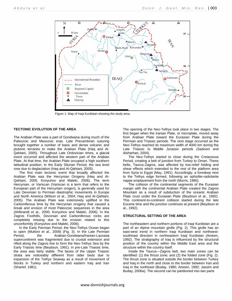
This study focuses on the Iraqi Kurdistan (Fig. 1) and includes four surface outcrops of Sargelu Formation. All the outcrop sections are located in the High Folded Zone of the mountain front (Fig. 2). The outcrop locations are: (1) Sargelu village near Surdash town (longitude: 45º 09ʹ 25ʺ and latitude: 35º 52ʹ 44ʺ); (2) Hanjeera village two km north west of Rania town (longitude: 44º 51ʹ 52ʺ and latitude: 36 17ʹ 08ʺ); (3) Barsarin village near Rawanduz in Balak valley (longitude: 44º 39ʹ 18ʺ and latitude: 36º 37ʹ 13ʺ); and (4) Gara Mountain in Gali-Zewki south of Amadia (longitude: 43º 25ʹ 30ʺ and latitude: 37º 00ʹ 28ʺ). METHODS AND MATERIALS
The data base for the study consists of surface outcrops. Field work on Sargelu outcrops and collecting samples were completed by the end of summer of 2009. A preliminary assessment of the stratigraphy was made by observing and describing outcrops in different parts of the area. The geometry of the sedimentary rock units and general relationships in each sequence were described. The selected outcrop sections have excellent sequences that reflect the main components of the depositional system.
The outcrop sections were measured from the base to the top of Sargelu outcrops using a Jacob’s staff and Brunton compass. The thickness, mineral composition, grain size, color, and sedimentary structures were recorded. Mineral composition was determined by hand specimen descriptions, petrographic thin sections, and scanning electron microscope (SEM).
The metric scale was used to measure sections. The true thickness was calculated for each outcrop separately. The thicknesses for some sections are approximate because of the steepness (inaccessibility) of the cliffs. The map scale for the measured sections is 1 cm equals 2 m while the horizontal scale for the measured correlation panel is 1 cm equals 3 km. Topographic maps were used to locate the outcrops, and photomosaic maps were taken to illustrate facies changes both vertically in each of the outcrops and laterally across the various outcrops.
The samples were prepared and thin sections made at the Salahaddin University, Department of Geology. Thin sections were studied at the Soran University, Department of Geosciences. The bulk analysis was performed at the Colorado School of Mines, Department of Geology and Geological Engineering on an ISI-100B scanning electron microscope.
A b d u l a e t a l D o n n . J . G e o l . M i n . R e s . | 003
www.donnishjournals.org
Figure 1: Map of Iraqi Kurdistan showing the study area.
TECTONIC EVOLUTION OF THE AREA
The Arabian Plate was a part of Gondwana during much of the Paleozoic and Mesozoic eras. Late Precambrian suturing brought together a number of basic and dense volcanic and plutonic terranes to make the Arabian Plate (Haq and Al-Qahtani, 2005). Throughout Late Ordovician times, a glacial event occurred and affected the western part of the Arabian Plate. At that time, the Arabian Plate occupied a high southern latitudinal position. In the Early Silurian Period, the sea level rose due to deglaciation (Haq and Al-Qahtani, 2005).
The first main tectonic event that broadly affected the Arabian Plate was the Hercynian Orogeny (Haq and Al-Qahtani, 2005; Konyuhov and Maleki, 2006). The term Hercynian, or Variscan (Variscan is a term that refers to the European part of the Hercynian orogen), is generally used for Late Devonian to Permian diastrophic movements in Europe and North America (Wilson et al., 2004; Haq and Al-Qahtani, 2005). The Arabian Plate was extensively uplifted in the Carboniferous time by the Hercynian orogeny that caused a break and erosion of most Paleozoic sequences in the area (Ahlbrandt et al., 2000; Konyuhov and Maleki, 2006). In the Zagros Foothills, Devonian and Carboniferous rocks are completely missing due to the erosion related to this unconformity (Konyuhov and Maleki, 2006).
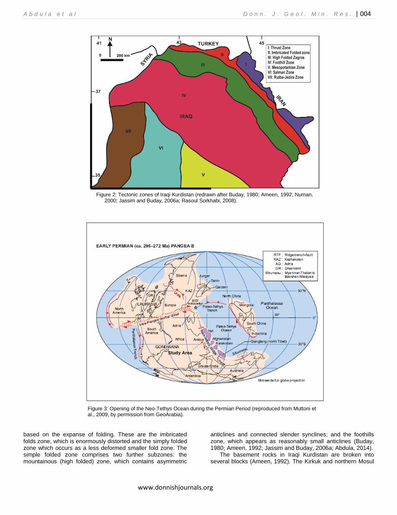
In the Early Permian Period, the Neo-Tethys Ocean began to open (Muttoni et al., 2009) (Fig. 3). In the Late Permian Period, the Arabian-Gondwana/Iranian-Laurasia supercontinent was fragmented due to crustal extension and rifted along the Zagros line to form the Neo-Tethys Sea by the Early Triassic time (Beydoun, 1991). In pre-Late Triassic time, the area was fairly stable. The facies of the Upper Triassic strata are noticeably different from older beds due to expansion of the Tethys Seaway as a result of movement of blocks in Turkey and northern and eastern Iraq and Iran (Sharief, 1981).
The opening of the Neo-Tethys took place in two stages. The first began when the Iranian Plate, or microplate, moved away from Arabian Plate toward the Eurasian Plate during the Permian and Triassic periods. The next stage occurred as the Neo-Tethys reached its maximum width of 4000 km during the Late Triassic to Middle Jurassic periods (Sadooni and Alsharhan, 2004).
The Neo-Tethys started to close during the Cretaceous Period, creating a belt of junction from Turkey to Oman. These belts, Taurus-Zagros, was affected by low-relief folding and shear effects which extended to the rest of the platform area from Syria to Egypt (May, 1991). Accordingly, a foredeep next to the Tethys edge formed, following an ophiolite-radiolarite nappe emplacement from the north (Murris, 1980).
The collision of the continental segments of the Eurasian margin with the continental Arabian Plate created the Zagros Mountain as a result of subduction of the oceanic Arabian Plate crust under the Eurasian Plate (Beydoun et al., 1992). This continent-to-continent collision started during the late Eocene time and the junction continues at present (Beydoun et al., 1992).
STRUCTURAL SETTING OF THE AREA
The northeastern and northern portions of Iraqi Kurdistan are a part of an Alpine mountain girdle (Fig. 2). This girdle has an east-west trend in northern Iraqi Kurdistan and northwest-southeast direction in northeastern Iraqi Kurdistan (Ameen, 1992). The stratigraphy of Iraq is influenced by the structural position of the country within the Middle East area and the structure within the country itself.
Inside the Taurus—Zagros belt, two main zones can be identified: (1) the thrust zone; and (2) the folded zone (Fig. 2). The thrust zone is situated outside the border between Turkey and Iraq in the north and close to the border between Iran and Iraq in the northeast (Buday, 1980; Ameen, 1992; Jassim and Buday, 2006a). The second can be partitioned into two parts
A b d u l a e t a l D o n n . J . G e o l . M i n . R e s . | 004
www.donnishjournals.org
Figure 2: Tectonic zones of Iraqi Kurdistan (redrawn after Buday, 1980; Ameen, 1992; Numan, 2000; Jassim and Buday, 2006a; Rasoul Sorkhabi, 2008).
Figure 3: Opening of the Neo-Tethys Ocean during the Permian Period (reproduced from Muttoni et al., 2009, by permission from GeoArabia).
based on the expanse of folding. These are the imbricated folds zone, which is enormously distorted and the simply folded zone which occurs as a less deformed smaller fold zone. The simple folded zone comprises two further subzones: the mountainous (high folded) zone, which contains asymmetric
anticlines and connected slender synclines; and the foothills zone, which appears as reasonably small anticlines (Buday, 1980; Ameen, 1992; Jassim and Buday, 2006a; Abdula, 2014).
The basement rocks in Iraqi Kurdistan are broken into several blocks (Ameen, 1992). The Kirkuk and northern Mosul
Study Area
A b d u l a e t a l D o n n . J . G e o l . M i n . R e s . | 005
www.donnishjournals.org
blocks are the main ones. The tectonic stability of the area stems from the activity of these fragmented pieces (Ameen, 1992).
STARTIGRAPHY
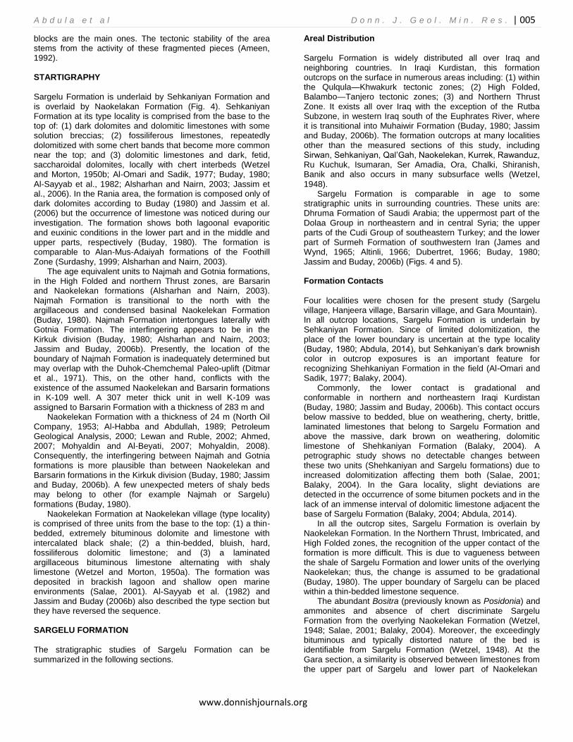
Sargelu Formation is underlaid by Sehkaniyan Formation and is overlaid by Naokelakan Formation (Fig. 4). Sehkaniyan Formation at its type locality is comprised from the base to the top of: (1) dark dolomites and dolomitic limestones with some solution breccias; (2) fossiliferous limestones, repeatedly dolomitized with some chert bands that become more common near the top; and (3) dolomitic limestones and dark, fetid, saccharoidal dolomites, locally with chert interbeds (Wetzel and Morton, 1950b; Al-Omari and Sadik, 1977; Buday, 1980; Al-Sayyab et al., 1982; Alsharhan and Nairn, 2003; Jassim et al., 2006). In the Rania area, the formation is composed only of dark dolomites according to Buday (1980) and Jassim et al. (2006) but the occurrence of limestone was noticed during our investigation. The formation shows both lagoonal evaporitic and euxinic conditions in the lower part and in the middle and upper parts, respectively (Buday, 1980). The formation is comparable to Alan-Mus-Adaiyah formations of the Foothill Zone (Surdashy, 1999; Alsharhan and Nairn, 2003).
The age equivalent units to Najmah and Gotnia formations, in the High Folded and northern Thrust zones, are Barsarin and Naokelekan formations (Alsharhan and Nairn, 2003). Najmah Formation is transitional to the north with the argillaceous and condensed basinal Naokelekan Formation (Buday, 1980). Najmah Formation intertongues laterally with Gotnia Formation. The interfingering appears to be in the Kirkuk division (Buday, 1980; Alsharhan and Nairn, 2003; Jassim and Buday, 2006b). Presently, the location of the boundary of Najmah Formation is inadequately determined but may overlap with the Duhok-Chemchemal Paleo-uplift (Ditmar et al., 1971). This, on the other hand, conflicts with the existence of the assumed Naokelekan and Barsarin formations in K-109 well. A 307 meter thick unit in well K-109 was assigned to Barsarin Formation with a thickness of 283 m and
Naokelekan Formation with a thickness of 24 m (North Oil Company, 1953; Al-Habba and Abdullah, 1989; Petroleum Geological Analysis, 2000; Lewan and Ruble, 2002; Ahmed, 2007; Mohyaldin and Al-Beyati, 2007; Mohyaldin, 2008). Consequently, the interfingering between Najmah and Gotnia formations is more plausible than between Naokelekan and Barsarin formations in the Kirkuk division (Buday, 1980; Jassim and Buday, 2006b). A few unexpected meters of shaly beds may belong to other (for example Najmah or Sargelu) formations (Buday, 1980).
Naokelekan Formation at Naokelekan village (type locality) is comprised of three units from the base to the top: (1) a thin-bedded, extremely bituminous dolomite and limestone with intercalated black shale; (2) a thin-bedded, bluish, hard, fossiliferous dolomitic limestone; and (3) a laminated argillaceous bituminous limestone alternating with shaly limestone (Wetzel and Morton, 1950a). The formation was deposited in brackish lagoon and shallow open marine environments (Salae, 2001). Al-Sayyab et al. (1982) and Jassim and Buday (2006b) also described the type section but they have reversed the sequence.
SARGELU FORMATION
The stratigraphic studies of Sargelu Formation can be summarized in the following sections.
Areal Distribution
Sargelu Formation is widely distributed all over Iraq and neighboring countries. In Iraqi Kurdistan, this formation outcrops on the surface in numerous areas including: (1) within the Qulqula—Khwakurk tectonic zones; (2) High Folded, Balambo—Tanjero tectonic zones; (3) and Northern Thrust Zone. It exists all over Iraq with the exception of the Rutba Subzone, in western Iraq south of the Euphrates River, where it is transitional into Muhaiwir Formation (Buday, 1980; Jassim and Buday, 2006b). The formation outcrops at many localities other than the measured sections of this study, including Sirwan, Sehkaniyan, Qal’Gah, Naokelekan, Kurrek, Rawanduz, Ru Kuchuk, Isumaran, Ser Amadia, Ora, Chalki, Shiranish, Banik and also occurs in many subsurface wells (Wetzel, 1948).
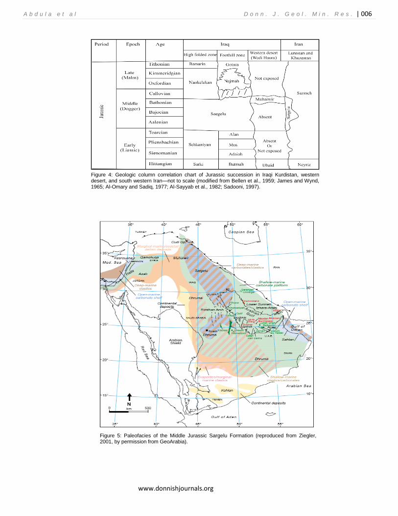
Sargelu Formation is comparable in age to some stratigraphic units in surrounding countries. These units are: Dhruma Formation of Saudi Arabia; the uppermost part of the Dolaa Group in northeastern and in central Syria; the upper parts of the Cudi Group of southeastern Turkey; and the lower part of Surmeh Formation of southwestern Iran (James and Wynd, 1965; Altinli, 1966; Dubertret, 1966; Buday, 1980; Jassim and Buday, 2006b) (Figs. 4 and 5).
Formation Contacts
Four localities were chosen for the present study (Sargelu village, Hanjeera village, Barsarin village, and Gara Mountain). In all outcrop locations, Sargelu Formation is underlain by Sehkaniyan Formation. Since of limited dolomitization, the place of the lower boundary is uncertain at the type locality (Buday, 1980; Abdula, 2014), but Sehkaniyan’s dark brownish color in outcrop exposures is an important feature for recognizing Shehkaniyan Formation in the field (Al-Omari and Sadik, 1977; Balaky, 2004).
Commonly, the lower contact is gradational and conformable in northern and northeastern Iraqi Kurdistan (Buday, 1980; Jassim and Buday, 2006b). This contact occurs below massive to bedded, blue on weathering, cherty, brittle, laminated limestones that belong to Sargelu Formation and above the massive, dark brown on weathering, dolomitic limestone of Shehkaniyan Formation (Balaky, 2004). A petrographic study shows no detectable changes between these two units (Shehkaniyan and Sargelu formations) due to increased dolomitization affecting them both (Salae, 2001; Balaky, 2004). In the Gara locality, slight deviations are detected in the occurrence of some bitumen pockets and in the lack of an immense interval of dolomitic limestone adjacent the base of Sargelu Formation (Balaky, 2004; Abdula, 2014).
In all the outcrop sites, Sargelu Formation is overlain by Naokelekan Formation. In the Northern Thrust, Imbricated, and High Folded zones, the recognition of the upper contact of the formation is more difficult. This is due to vagueness between the shale of Sargelu Formation and lower units of the overlying Naokelekan; thus, the change is assumed to be gradational (Buday, 1980). The upper boundary of Sargelu can be placed within a thin-bedded limestone sequence.
The abundant Bositra (previously known as Posidonia) and ammonites and absence of chert discriminate Sargelu Formation from the overlying Naokelekan Formation (Wetzel, 1948; Salae, 2001; Balaky, 2004). Moreover, the exceedingly bituminous and typically distorted nature of the bed is identifiable from Sargelu Formation (Wetzel, 1948). At the Gara section, a similarity is observed between limestones from the upper part of Sargelu and lower part of Naokelekan
A b d u l a e t a l D o n n . J . G e o l . M i n . R e s . | 006
www.donnishjournals.org
Figure 4: Geologic column correlation chart of Jurassic succession in Iraqi Kurdistan, western desert, and south western Iran—not to scale (modified from Bellen et al., 1959; James and Wynd, 1965; Al-Omary and Sadiq, 1977; Al-Sayyab et al., 1982; Sadooni, 1997).
Figure 5: Paleofacies of the Middle Jurassic Sargelu Formation (reproduced from Ziegler, 2001, by permission from GeoArabia).
A b d u l a e t a l D o n n . J . G e o l . M i n . R e s . | 007
www.donnishjournals.org
formations (Balaky, 2004). The upper Sargelu Formation, at the Hanjeera village locality, is analogous to that of the Barsarin village locality and is characterized by the abundance of solution collapse breccia (Salae, 2001).
The Callovian break is a well-known break at the upper boundary of the formation all over western and southwestern Iraq where sufficient uplift occurred (Buday, 1980; Marouf, 1999; Balaky, 2004). In subsurface sections, north and west of Mosul, considerable amounts of the Middle Jurassic succession, including Sargelu Formation and the entire sequence of the Upper Jurassic and Berriasian rock succession, are absent (Wetzel, 1948; Ameen, 1992). In this area, Sargelu Formation is overlain by Aptian (or Albian?) Sarmord Formation and appears to be eroded. The total number of eroded beds is different throughout the area (Wetzel, 1948). The Callovian break is reported at western Khuzestan and Lurestan in Iran (Setudehnia, 1978). Similarly, this disconformity was confirmed at Emam Hasan and at Masjed-e Suleyman in Iran (James and Wynd, 1965).
Age
The age of the underlying Upper Sehkaniyan Formations is not determined on faunal evidence. Age is determined based on the stratigraphic position and relationship to other (Mus and Middle Sehkaniyan) formations. Determination of the Toarcian age for the upper part of Sehkaniyan Formation is based on their position between the Pliensbachian Middle Sehkaniyan Formation and Sargelu Formation (Surdashy, 1999).
The age of the overlying Naokelekan Formation has been determined based on its fossil content which has been found to be Early Callovian-Kimmeridgian (Buday, 1980; Jassim and Buday, 2006b).
The lower boundary is gradational, conformable, and unidentifiable, which is represented by gradual facies that change from brownish dolomitic limestone to bluish dolomitic limestone. The upper part of Sargelu Formation represents shallow facies. There is no evidence for nonconformity in the lower and upper boundaries. The marine transgression led to a facies change at the beginning of Late Toarcian megasequence, thus, the Late Toarcian-Late Bathonian age of Sargelu Formation was determined by Wetzel (1948), Al-Omari and Sadiq (1977), Buday (1980), Al-Sayyab et al. (1982), Qaddouri (1986), Alsharhan and Nairn (2003), and Jassim and Buday (2006b). This age, avoids all other assumptions, such as those offered by Qaddouri (1972), Al-Dujaily (1994), Surdashy (1999), Al-Ahmed (2001), Balaky (2004), Peters et al. (2005b), and Zumberge (2010, pers. comm.) including Bajocian, Aalenian-Bajocian, Aalenian-Bathonian, Aalenian-Bathonian, Late Bathonian-Early Callovian, Bajocian-Callovian, Bajocian-Bathonian, respectively.
The age-equivalent formation of the upper Sargelu Formation in Iraq is Muhaiwir Formation, which Wetzel (1951) dated as Bathonian, as did Al-Sayyab et al. (1982), Alsharhan and Nairn (2003), and Jassim and Buday (2006b). Al-Hadithi (1989) dated it as Bathonian-Callovian.
Thickness
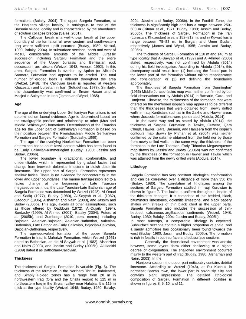
The thickness of Sargelu Formation is variable (Fig. 6). The thickness of the formation in the Northern Thrust, Imbricated, and Simply Folded zones has a range from 20 m in northwestern Iraq (Ora and the Chalki region) to 125 m in northeastern Iraq in the Sirwan valley near Halabja. It is 115 m thick at the type locality (Wetzel, 1948; Buday, 1980; Balaky,
2004; Jassim and Buday, 2006b). In the Foothill Zone, the thickness is significantly high and has a range between 250–500 m (Ditmar et al., 1971; Buday, 1980; Jassim and Buday, 2006b). The thickness of Sargelu Formation in the Iran (Lurestan, Khuzestan) area is 152–213 m, and in Kuwait has a range between 75–83 m, in Burgan and Umm Gudair, respectively (James and Wynd, 1965; Jassim and Buday, 2006b).
The thickness of Sargelu Formation of 110 m and 148 m at type locality that Al-Sayyab et al. (1982) and Al-Ahmed (2006) stated, respectively, was not confirmed by Abdula (2014) during his field investigation. According to Abdula (2014), this discrepancy could result from (1) including the folded part in the lower part of the formation without taking reappearance into consideration or (2) not defining the boundaries appropriately.
The thickness of Sargelu Formation from Dunnington’ (1955) Middle Jurasic-facies map was neither confirmed by our field observations nor by Abdula (2014) in Barsarin, Gara, and Hanjeera. Likewise, the thicknesses of the formation that were offered on the mentioned isopach map appea rs to be different than the thicknesses that were obtained from newly drilled wells in Iraqi Kurdistan, such as in the Zakho and Hawler areas where Jurassic formations were penetrated (Abdula, 2014).
In the same way and as stated by Abdula (2014), the thickness of Sargelu Formation in Tawke, Guwear, Qara Chugh, Hawler, Gara, Barsarin, and Hanjeera from the isopach contours map drawn by Pitman et al. (2004) was neither confirmed by the data he obtained from the field nor by those from newly drilled wells. In the same way, the thickness of the formation in the Late Toarcian–Early Tithonian Megasequence map drawn by Jassim and Buday (2006b) was not confirmed by the thickness of the formation in Hawler and Tawke which was attained from the newly drilled wells (Abdula, 2014). Lithology
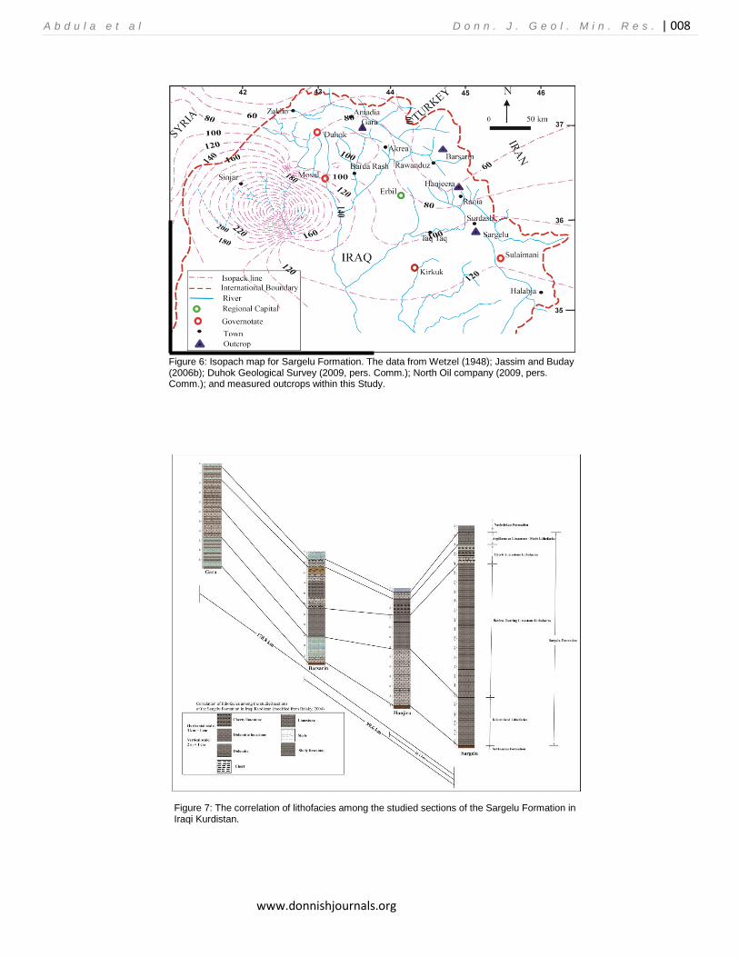
Sargelu Formation has very constant lithological conformation and can be correlated over a distance of more than 350 km (Buday, 1980). The correlation of lithofacies among the sections of Sargelu Formation studied in Iraqi Kurdistan is shown in figure 7. The facies is uniform throughout, inspite of the thickness changes. It is comprised of thin-bedded, black, bituminous limestones, dolomitic limestone, and black papery shales with streaks of thin black chert in the upper parts. Sargelu Formation also includes the succession of thin-bedded, calcareous-argillaceous sediments (Wetzel, 1948; Buday, 1980; Balaky, 2004; Jassim and Buday, 2006b). In most outcrops, a comparable lithology is expected. Subsurface sections contain a higher proportion of shale, and a sandy admixture has occasionally been found towards the west (Buday, 1980; Jassim and Buday, 2006b). The formation is rich in fossils in both surface and subsurface sections.
Generally, the depositional environment was anoxic; however, some layers show either shallowing or a higher degree of oxygenation. The shallower environment occurred mainly to the western part of Iraq (Buday, 1980; Alsharhan and Nairn, 2003). In the
Hanjeera section, the upper part noticeably contains detrital limestone. According to Wetzel (1948), at Ru Kuchuk in northeast Barzan town, the lower part is obviously silty and contains plant impressions. The detailed lithological composition of Sargelu Formation in different localities is shown in figures 8, 9, 10, and 11.
A b d u l a e t a l D o n n . J . G e o l . M i n . R e s . | 008
www.donnishjournals.org
Figure 6: Isopach map for Sargelu Formation. The data from Wetzel (1948); Jassim and Buday (2006b); Duhok Geological Survey (2009, pers. Comm.); North Oil company (2009, pers. Comm.); and measured outcrops within this Study.
Figure 7: The correlation of lithofacies among the studied sections of the Sargelu Formation in Iraqi Kurdistan.
A b d u l a e t a l D o n n . J . G e o l . M i n . R e s . | 009
www.donnishjournals.org
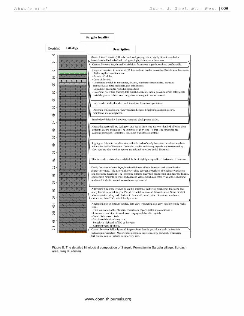
Figure 8: The detailed lithological composition of Sargelu Formation in Sargelu village, Surdash area, Iraqi Kurdistan.

A b d u l a e t a l D o n n . J . G e o l . M i n . R e s . | 010
www.donnishjournals.org
Figure 9: The detailed lithological composition of Sargelu Formation in Hanjeera village, Rania area, Iraqi Kurdistan.
A b d u l a e t a l D o n n . J . G e o l . M i n . R e s . | 011
www.donnishjournals.org
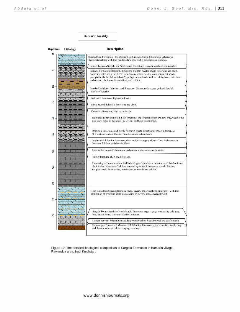
Figure 10: The detailed lithological composition of Sargelu Formation in Barsarin village, Rawanduz area, Iraqi Kurdistan.
A b d u l a e t a l D o n n . J . G e o l . M i n . R e s . | 012
www.donnishjournals.org
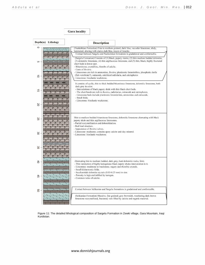
Figure 11: The detailed lithological composition of Sargelu Formation in Zewki village, Gara Mountain, Iraqi Kurdistan.
A b d u l a e t a l D o n n . J . G e o l . M i n . R e s . | 013
www.donnishjournals.org
Microfacies Analysis
Three main microfacies types can be recognized within Sargelu Formation, they are lime mudstone, wackestone, and Packstone. Lime mudstone
Based on Dunham (1962), this facies consists of micrite with rare fossil content, generally less than 10%. This microfacies can be seen in different parts of Sargelu Formation in the sections studied. This microfacies occurs at near the lower part of Surdash section. At Hanjeera section, this microfacies is located at near the lower and upper parts of Sargelu Formation. At Gara section this microfacies is common within the middle and near the upper parts (cherty limestone).
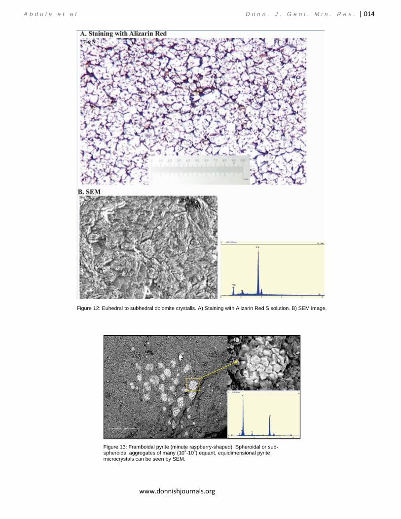
Some diagenetic processes can be recognized through this microfacies type (lime mudstone) within Sargelu Formation. They are: severe neomorphism of micrite to microsparite; compaction that created stylolite; and dolomitization. The matrix of this facies underwent the late dolomitization represented by euhedral or subhedral dolomite crystal (Fig. 12). In some parts, fractures can also be seen. Additionally, some authigenic minerals such as pyrite and iron oxide (ferruginous) can be observed within this microfacies. Pyrite is formed in anoxic marine sediments by the reaction of dissolved sulfide, produced by microbial sulfate reaction, with detrital iron-bearing minerals (Berner 1970). The initial products are often iron sulfide minerals which are probably transformed to pyrite by reaction with dissolved sulfide (Rickard and Luther, 1997).
Although there are a variety of transformation pathways, the extent of pyrite formation is thought to be limited either by the microbial production of sulfide or by the availability of reactive iron minerals (Canfield and Raiswell, 1991). Framboidal pyrite (Fig. 13) are spherical or subspherical clusters of submicron to micron-sized pyrite crystals densely packed together (Wilkin and Barnes, 1997) and are the most common pyrite texture in many sedimentary environments (Love and Amstutz, 1966; Stene, 1979; Wiese and Fyfe, 1986; Butler and Rickard, 2000; Paktunc and Davé, 2002). Based on (Garcia-Guinea et al., 1997) framboidal pyrite is very common in reducing sediments such as modern dark muds, or in ancient dark shales and limestones, as can be seen here within these lithologies at Sargelu Formation. At some parts, fractures can also be seen. Wackestone
Based on Dunham (1962), grains of wackestone range between 10- 50% in micritic matrix. This microfacies can be found near upper parts at Surdash section and all parts of Hanjeera section at Sargelu Formation. Some skeletal grains such as Bositra or thin shelly pelagic pelecypod (Bositra), gastropod, algal filaments and pelagic microorganism (radiolarian, calcispheres), and ostracod occur at this microfacies. Based on Flugel (2010) Devonian and Carboniferous calcispheres are abundant in restricted and semi-restricted lagoonal environments and in back-reef settings, but most of the Jurassic and Cretaceous calcispheres occur in pelagic limestones as can be seen at Sargelu Formation (Fig. 14).
Bositra bearing wackestone can be found at the lower part and in some upper parts (within cherty limestone). At Suradash section Bositra–bearing limestone can be found in the upper part within cherty limestones. The main feature of this facies is
Bositra valves. The gastropods, ostracods, and pelecypods bioclasts may be transported by storm. At the upper part of this formation at the Hanjeera section wackestone with calcisphere, radiolarian and less ostracod have been found. This microfacies is identified in the cherty limestone lithofacies as mentioned before at the upper part of formation. Calcisphere may be of radiolarian origin (Scholle, 1978) because of many calcareous molds of radiolarian accompanying these constituents. The matrix is rich in organic and clay minerals as shown by scanning electron microscopy (SEM). Diagenetic processes include silisification, compaction and authigenic pyrite. At Gara section, the dolomitized wackestone is identified as scattered parts within Bositra. Packstone
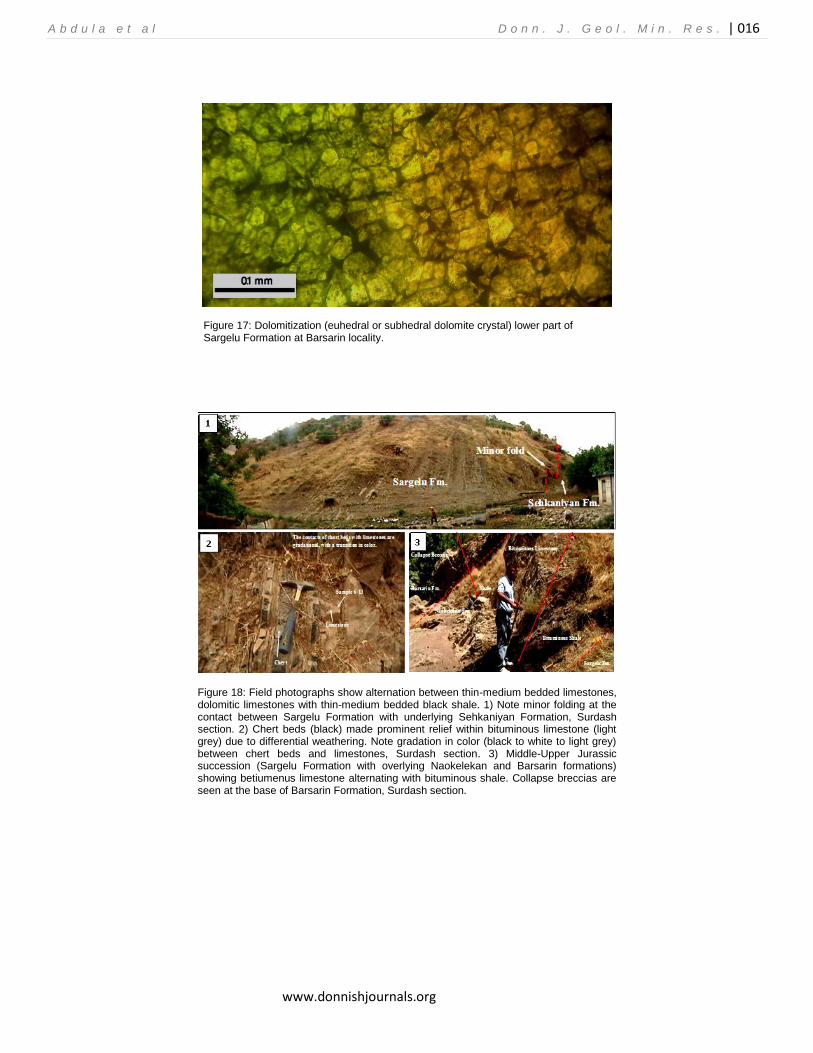
Based on Dunham (1962), skeletal grains in this facies are more than 50%. This microfacies can be founded at all sections. At this facies very high amount of thin shells of Bositra (pelagic pelecypod or Bositra) occurs (Fig. 15). This microfacies can be found at the upper part of Surdash section at cherty limestone lithofacies. At the Hanjeera section, peloidal packstone were present (Fig. 16). Sparitization has taken place and we named this microfacies as peloidal packstone (not peloidal grainstone). Bioclastic packstone includes mollusk, ostracod, and calcisphere bioclasts. At Barsarin section, silisification can be observed at mollusk. Common diagenetic processes at this microfacies are dolomitization, compaction, neomorphism (micrite to sparite), silicification, and iron oxide or ferruginous. Finally, the lower part of Sargelu Formation at Barsarin locality is completely dolomitized (Fig. 17).
SEDIMENTOLOGIC AND STRATIGRAPHIC DESCRIPTION OF SARGELU FORMATION
The Sargelu Formation from four different sections was studied (Surdash, Hanjeera, Barsarin and Gara), the field work carried out in order to observe and record all geologic relationships (i.e. stratigraphy, sedimentology, paleontology etc.), and samples were collected along all sections. Then thin sections were made and studied under a polarizing microscope. A brief description of each section is sited below: Surdash section
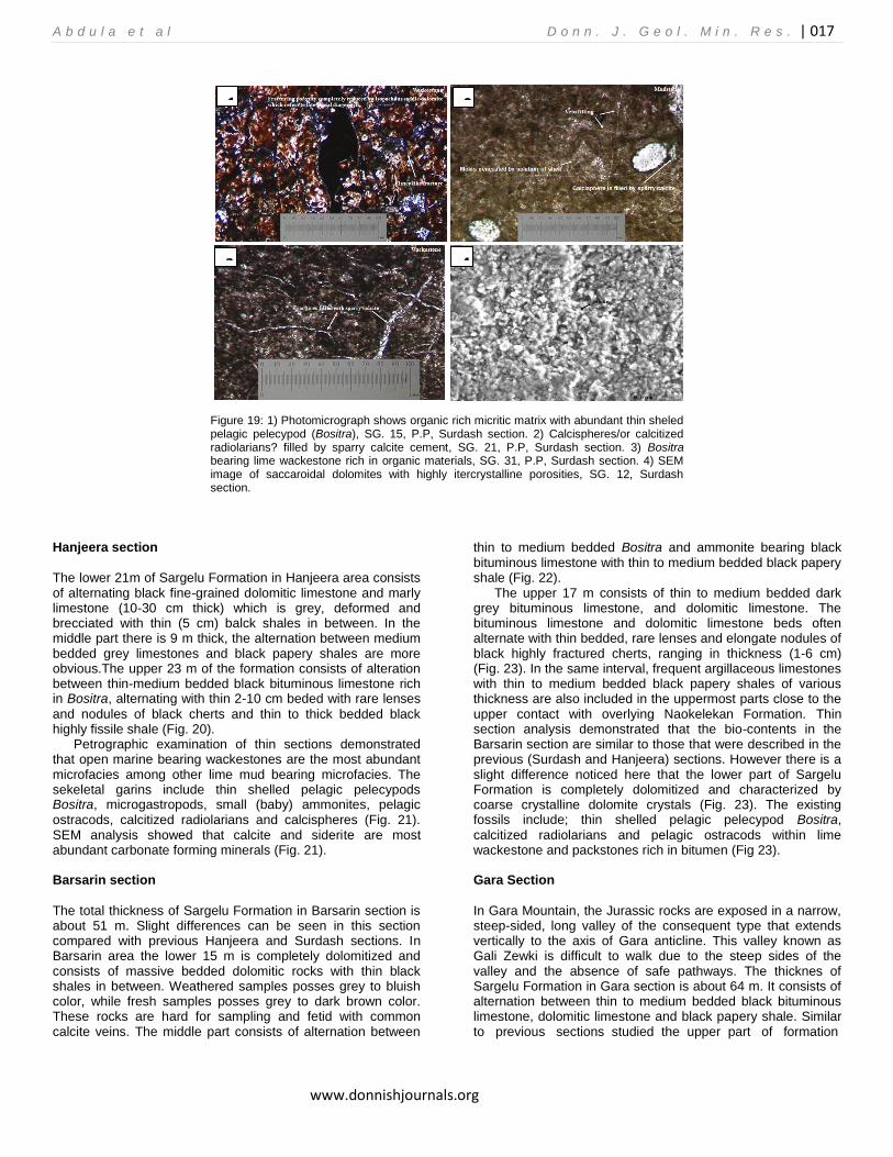
The lithological composition of the formation consists of thin- medium (10-40 cm) bedded, black, bituminous limestones, dolomitic limestones, and black papery shales with streaks of thin black cherts with rare lenses and nodules in the upper parts. Field observations demonstrated that the contact between cherts and limestone beds are graditional (Fig. 18). Thin section and SEM analysis showed that the limestones consist of organic rich micritic ground mass with abundant open marine faunas like thin sheled pelagic pelecypod Bositra, ammonites, planktonic forams, calcitized radiolarians, calcispheres and pelagic ostracods (Fig. 19). The common microfacies are Bositra bearing lime wackestone-packstone. Non skeletal grains include peloids only. Dolomitization (complete dolomitization and floating rhombs), silicification and fracturings are the most abundant diagenetic processes affecting the limestones of Sargelu Formation (Fig. 19).
A b d u l a e t a l D o n n . J . G e o l . M i n . R e s . | 014
www.donnishjournals.org
Figure 12: Euhedral to subhedral dolomite crystalls. A) Staining with Alizarin Red S solution. B) SEM image.
Figure 13: Framboidal pyrite (minute raspberry-shaped). Spheroidal or sub-spheroidal aggregates of many (10
2-10
5) equant, equidimensional pyrite
microcrystals can be seen by SEM.

A b d u l a e t a l D o n n . J . G e o l . M i n . R e s . | 015
www.donnishjournals.org
Figure 14: Wackestone bearing Bositra and Calsispheres (B: Bositra and C: Calcisphere).
Figure 15: Bositra Packstone (Bositra or thin shelly pelagic pelecypod).
Figure 16: Peloidal packstone (P: peloid with micrite that changed to microspar and sparite).
A b d u l a e t a l D o n n . J . G e o l . M i n . R e s . | 016
www.donnishjournals.org
Figure 17: Dolomitization (euhedral or subhedral dolomite crystal) lower part of Sargelu Formation at Barsarin locality.
Figure 18: Field photographs show alternation between thin-medium bedded limestones, dolomitic limestones with thin-medium bedded black shale. 1) Note minor folding at the contact between Sargelu Formation with underlying Sehkaniyan Formation, Surdash section. 2) Chert beds (black) made prominent relief within bituminous limestone (light grey) due to differential weathering. Note gradation in color (black to white to light grey) between chert beds and limestones, Surdash section. 3) Middle-Upper Jurassic succession (Sargelu Formation with overlying Naokelekan and Barsarin formations) showing betiumenus limestone alternating with bituminous shale. Collapse breccias are seen at the base of Barsarin Formation, Surdash section.
A b d u l a e t a l D o n n . J . G e o l . M i n . R e s . | 017
www.donnishjournals.org
Figure 19: 1) Photomicrograph shows organic rich micritic matrix with abundant thin sheled pelagic pelecypod (Bositra), SG. 15, P.P, Surdash section. 2) Calcispheres/or calcitized radiolarians? filled by sparry calcite cement, SG. 21, P.P, Surdash section. 3) Bositra bearing lime wackestone rich in organic materials, SG. 31, P.P, Surdash section. 4) SEM image of saccaroidal dolomites with highly itercrystalline porosities, SG. 12, Surdash section.
Hanjeera section
The lower 21m of Sargelu Formation in Hanjeera area consists of alternating black fine-grained dolomitic limestone and marly limestone (10-30 cm thick) which is grey, deformed and brecciated with thin (5 cm) balck shales in between. In the middle part there is 9 m thick, the alternation between medium bedded grey limestones and black papery shales are more obvious.The upper 23 m of the formation consists of alteration between thin-medium bedded black bituminous limestone rich in Bositra, alternating with thin 2-10 cm beded with rare lenses
and nodules of black cherts and thin to thick bedded black highly fissile shale (Fig. 20).
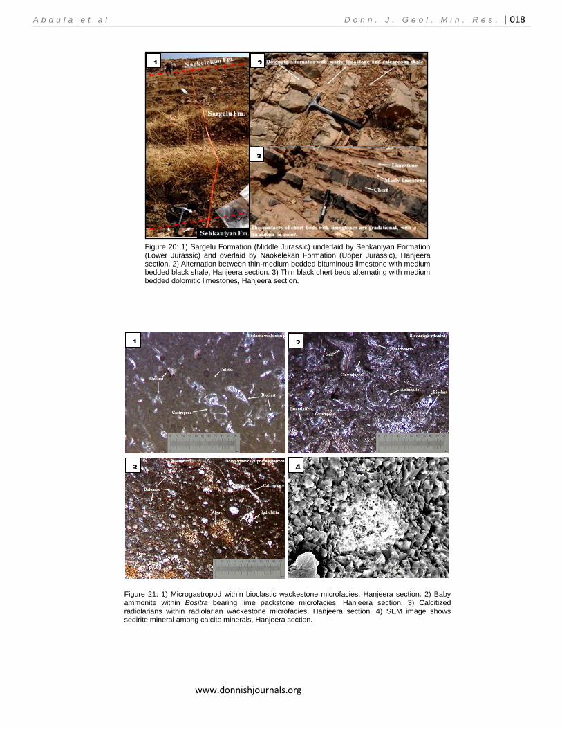
Petrographic examination of thin sections demonstrated that open marine bearing wackestones are the most abundant microfacies among other lime mud bearing microfacies. The sekeletal garins include thin shelled pelagic pelecypods Bositra, microgastropods, small (baby) ammonites, pelagic ostracods, calcitized radiolarians and calcispheres (Fig. 21). SEM analysis showed that calcite and siderite are most abundant carbonate forming minerals (Fig. 21). Barsarin section
The total thickness of Sargelu Formation in Barsarin section is about 51 m. Slight differences can be seen in this section compared with previous Hanjeera and Surdash sections. In Barsarin area the lower 15 m is completely dolomitized and consists of massive bedded dolomitic rocks with thin black shales in between. Weathered samples posses grey to bluish color, while fresh samples posses grey to dark brown color. These rocks are hard for sampling and fetid with common calcite veins. The middle part consists of alternation between
thin to medium bedded Bositra and ammonite bearing black bituminous limestone with thin to medium bedded black papery shale (Fig. 22).
The upper 17 m consists of thin to medium bedded dark grey bituminous limestone, and dolomitic limestone. The bituminous limestone and dolomitic limestone beds often alternate with thin bedded, rare lenses and elongate nodules of black highly fractured cherts, ranging in thickness (1-6 cm) (Fig. 23). In the same interval, frequent argillaceous limestones with thin to medium bedded black papery shales of various thickness are also included in the uppermost parts close to the upper contact with overlying Naokelekan Formation. Thin section analysis demonstrated that the bio-contents in the Barsarin section are similar to those that were described in the previous (Surdash and Hanjeera) sections. However there is a slight difference noticed here that the lower part of Sargelu Formation is completely dolomitized and characterized by coarse crystalline dolomite crystals (Fig. 23). The existing fossils include; thin shelled pelagic pelecypod Bositra,
calcitized radiolarians and pelagic ostracods within lime wackestone and packstones rich in bitumen (Fig 23).
Gara Section
In Gara Mountain, the Jurassic rocks are exposed in a narrow, steep-sided, long valley of the consequent type that extends vertically to the axis of Gara anticline. This valley known as Gali Zewki is difficult to walk due to the steep sides of the valley and the absence of safe pathways. The thicknes of Sargelu Formation in Gara section is about 64 m. It consists of alternation between thin to medium bedded black bituminous limestone, dolomitic limestone and black papery shale. Similar to previous sections studied the upper part of formation
1 2
3 4
A b d u l a e t a l D o n n . J . G e o l . M i n . R e s . | 018
www.donnishjournals.org
Figure 20: 1) Sargelu Formation (Middle Jurassic) underlaid by Sehkaniyan Formation (Lower Jurassic) and overlaid by Naokelekan Formation (Upper Jurassic), Hanjeera section. 2) Alternation between thin-medium bedded bituminous limestone with medium bedded black shale, Hanjeera section. 3) Thin black chert beds alternating with medium bedded dolomitic limestones, Hanjeera section.
Figure 21: 1) Microgastropod within bioclastic wackestone microfacies, Hanjeera section. 2) Baby ammonite within Bositra bearing lime packstone microfacies, Hanjeera section. 3) Calcitized radiolarians within radiolarian wackestone microfacies, Hanjeera section. 4) SEM image shows sedirite mineral among calcite minerals, Hanjeera section.
1 2
3
1 2
3 4
A b d u l a e t a l D o n n . J . G e o l . M i n . R e s . | 019
www.donnishjournals.org
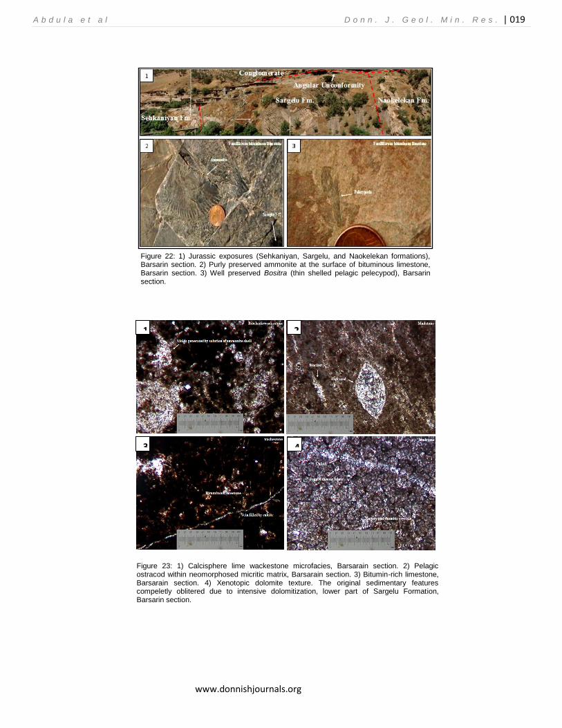
Figure 22: 1) Jurassic exposures (Sehkaniyan, Sargelu, and Naokelekan formations), Barsarin section. 2) Purly preserved ammonite at the surface of bituminous limestone, Barsarin section. 3) Well preserved Bositra (thin shelled pelagic pelecypod), Barsarin section.
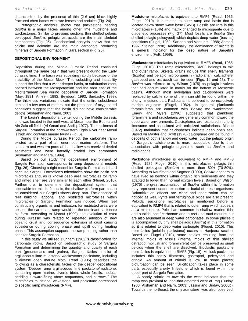
Figure 23: 1) Calcisphere lime wackestone microfacies, Barsarain section. 2) Pelagic ostracod within neomorphosed micritic matrix, Barsarain section. 3) Bitumin-rich limestone, Barsarain section. 4) Xenotopic dolomite texture. The original sedimentary features compeletly oblitered due to intensive dolomitization, lower part of Sargelu Formation, Barsarin section.
1 2
3 4
A b d u l a e t a l D o n n . J . G e o l . M i n . R e s . | 020
www.donnishjournals.org
characterized by the presence of thin (2-6 cm) black highly fractured chert bands with rare lenses and nodules (Fig. 24).
Petrographic analysis shows that packestone bearing Bositra is a major facies among other lime mudstone and wackestones. Similar to previous sections thin shelled pelagic pelecypod Bositra, pelagic ostracods are the main skeletal components (Fig. 25). Geochemical analysis shows that the calcite and dolomite are the main carbonate producing minerals of Sargelu Formation in Gara section (Fig. 25). DEPOSITIONAL ENVIRONMENT
Deposition during the Middle Jurassic Period continued throughout the same basin that was present during the Early Jurassic time. The basin was subsiding rapidly because of the instability of the Mosul Block. This subsiding and instability support the idea that a wider deeper basin, or subduction zone, opened between the Mesopotamian and the area east of the Mediterranean Sea during deposition of Sargelu Formation (May, 1991; Ameen, 1992; Beydoun, 1993; Surdashy, 1999). The thickness variations indicate that the entire subsidence attained a few tens of meters, but the presence of oxygenated conditions suggest that the basin did not have considerable depths (Alsharhan and Nairn, 2003).
The basin’s depositional center during the Middle Jurassic time was located in the northwest at Mosul near the Butma and Ain Zala oil fields (Al-Omari and Sadiq, 1977). The thickness of Sargelu Formation at the northwestern Tigris River near Mosul is high and contains marine fauna (Fig. 6).
During the Middle Jurassic Period, the carbonate ramp existed as a part of an enormous marine platform. The southern and western parts of the shallow sea received detrital sediments and were laterally graded into carbonates (Alsharhan and Magara, 1994).
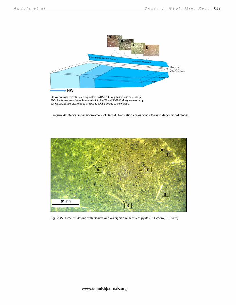
Based on our study the depositional environment of Sargelu Formation corresponds to ramp depositional models (Fig. 26). Choosing a right model for Sargelu Formation is hard because Sargelu Formation's microfacies show the basin part microfacies and, as is known deep area microfacies for ramp and rimed shelf are very similar to each other (Flugel, 2010). Furthermore, to determine the depositional system that applicable for middle Jurassic, the shallow platform part has to be considered but Sargelu shows deep part. The absence of reef building, lagoonal, and restricted microfacies within microfacies of Sargelu Formation was noticed. When reef constructing organisms and indicators for restricted area were absent, the carbonate ramp would be the dominant carbonate platform. According to Marouf (1999), the evolution of crust during Jurassic was related to repeated addition of new oceanic crust and consequence extension of crust causing subsidence during cooling phase and uplift during heating phase. This assumption supports the ramp setting rather than shelf for Sargelu Formation.
In this study we utilized Dunham (1962)'s classification for carbonate rocks. Based on petrographic study of Sargelu Formation and determining the quantity and quality of each part (groundmass and grains), Sargelu facies consist of argillaceous-lime mudstone/ wackestone/ packstone, including a diverse open marine biota. Read (1985) describes the following as a characteristic facies of the deeper depositional system ―Deeper ramp argillaceous lime packstone/mudstone, containing open marine, diverse biota, whole fossils, nodular bedding, upward-fining storm sequences, and burrows.‖ The microfacies mudstone, wakestone, and packstone correspond to specific ramp microfaceis (RMF).
Mudstone microfacies is equivalent to RMF5 (Read, 1985;
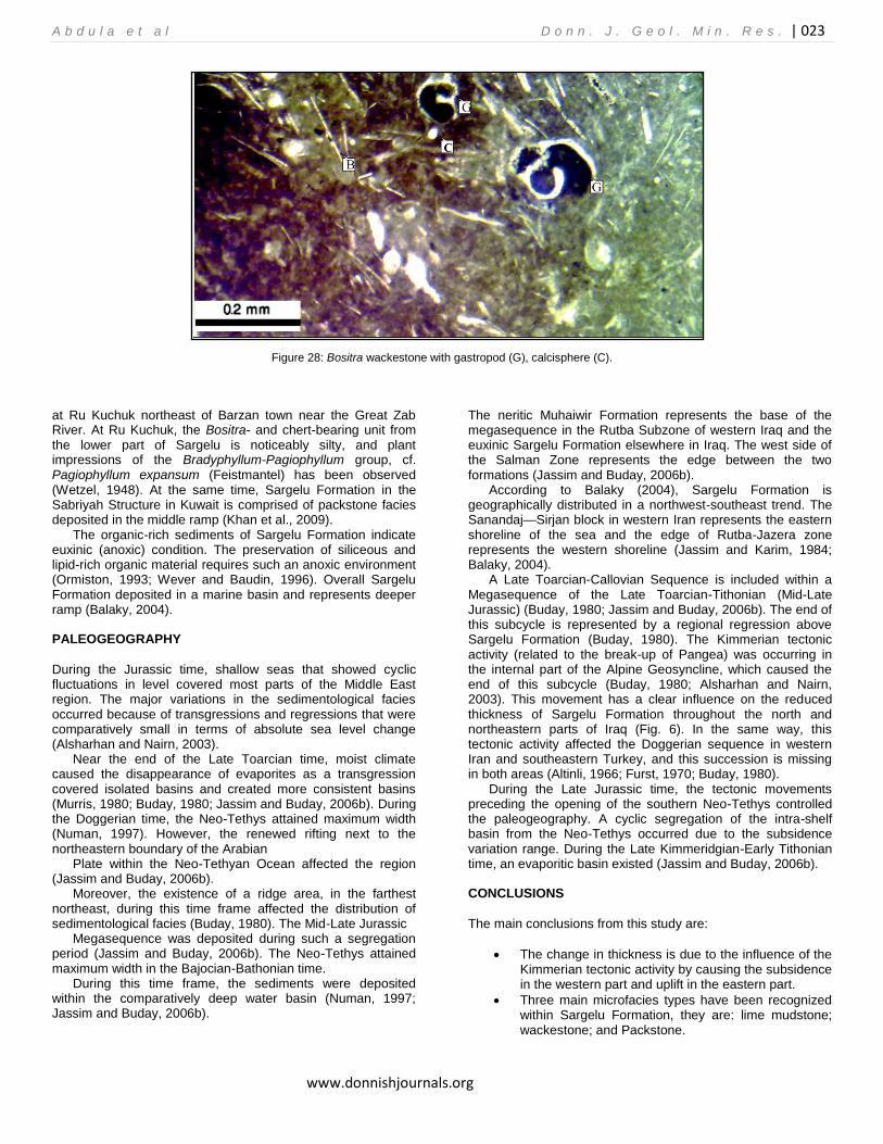
Flugel, 2010). It is related to outer ramp and basin that is located below storm wave base (SWB). Fossils are rare in this microfacies (<10%) and matrix changed to microsparite due to diagenetic processes (Fig. 27). Most fossils are Bositra (thin shelled pelagic pelecypod) which depicts deep water (basinal) conditions (Flugel, 1982; Sartorio and Venturim, 1988; Ahmed, 1997; Steiner, 1998). Additionally, the dominance of micrite is a general indicator for the deep nature of Sargelu’s environment (Folk, 1959). Wackestone microfacies is equivalent to RMF3 (Read, 1985;
Flugel, 2010). This ramp microfacies, RMF3 belongs to mid and outer ramp. Skeletal grains include thin shelly filaments (Bositra) and pelagic microorganism (radiolarian, calcisphere,
gastropod and ostracod) can be seen (Figs. 14 and 28). The Bositra was referred to by Wilson (1975) as pelagic bivalves that had accumulated in matrix on the bottom of Mesozoic basins. Although most radiolarian and calcispheres were replaced by calcite some of them can still be found within the cherty limestone part. Radiolarian is believed to be exclusively marine organism (Flugel, 1982). In general planktonic foraminiferas are common with Bositra-lime wackestone.
Emery and Myers (1996) suggested that planktonic foraminifera and radiolarians are generally common toward the deep water environments. Calcispheres are restricted in cherty limestone and associated with calcitized radiolarians. Bishop (1972) maintains that calcispheres indicate deep open sea. Based on Master and Scott (1978) calcisphere can be found in deposits of both shallow and deep water, but the pelagic origin of Sargelu’s calcispheres is more acceptable due to their association with pelagic organisms such as Bositra and radiolarians. Packstone microfacies is equivalent to RMF4 and RMF3
(Read, 1985; Flugel, 2010). In this microfacies, pelagic thin shelled pelecypod (Bositra) is more than 60% (70-80%). According to Kauffman and Sagmen (1990), Bositra appears to have lived as benthos within organic rich sediments and they adapted to lower than normal oxygen levels. Based on Wilson (1975) the great accumulation of Bositra within this formation may represent sudden extinction or burial of these organisms. Dolomitization effects are clear and sparitization can be noticed as well. Pyrite and ferruginous oxide are also present. Peloidal packstone microfacies as mentioned before is equivalent to RMF4 that is related to outer ramp which appears as a microspare. Peloid are common in shallow marine tidal and subtidal shelf carbonate and in reef and mud mounds but are also abundant in deep water carbonates. In some places it is accompanied by tiny shell pelagic (Bositra) in this formation so it is related to deep water carbonate (Flugel, 2010). This microfacies (peloidal packstone) occurs at Hanjeera section. Based on Flugel (2010), some peloids resulting from the internal molds of fossils (internal molds of thin shelled ostracod, mollusk and foraminifera) can be preserved as small peloids when the shell are dissolved. Bioclastic packstone microfacies is equivalent to RMF3 (Fig. 15). Mollusk packstone includes thin shelly filaments, gastropod, pelecypod and crinoid. An amount of crinoid is low. In some places; bioturbation can be seen. Silicification takes place in some parts especially cherty limestone which is found within the upper part of Sargelu Formation.
A sandy admixture towards the west indicates that the ramp was proximal to land that emerged west of Iraq (Buday, 1980; Alsharhan and Nairn, 2003; Jassim and Buday, 2006b). Towards the northeast, the silty admixture was also observed

A b d u l a e t a l D o n n . J . G e o l . M i n . R e s . | 021
www.donnishjournals.org
Figure 24: 1) Northern limb of Gara anticline shows the exposure of Jurassic formations. 2) Minor folding a result of tectonic effect on the formation particularly in the argillaceous parts, upper Sargelu Formation, Gara section. 3) Chert beds altarnating with thin limestones and thin shales, upper part of Sargelu Formation, Gara section.
Figure 25: 1) Bositra bearing lime packstone. Note irregular distribution of Bositra valves, Sargelu Formation, Gara section. 2) Neomorphosed lime mudstone is containing pelagic ostracod, Sargelu Formation, Gara section. 3, 4) Dolomitization within the lower part of Sargelu Formation, Gara section.
A b d u l a e t a l D o n n . J . G e o l . M i n . R e s . | 022
www.donnishjournals.org
Figure 26: Depositional environment of Sargelu Formation corresponds to ramp depositional model.
Figure 27: Lime-mudstone with Bositra and authigenic minerals of pyrite (B: Bositra, P: Pyrite).
A b d u l a e t a l D o n n . J . G e o l . M i n . R e s . | 023
www.donnishjournals.org
Figure 28: Bositra wackestone with gastropod (G), calcisphere (C).
at Ru Kuchuk northeast of Barzan town near the Great Zab River. At Ru Kuchuk, the Bositra- and chert-bearing unit from the lower part of Sargelu is noticeably silty, and plant impressions of the Bradyphyllum-Pagiophyllum group, cf. Pagiophyllum expansum (Feistmantel) has been observed (Wetzel, 1948). At the same time, Sargelu Formation in the Sabriyah Structure in Kuwait is comprised of packstone facies deposited in the middle ramp (Khan et al., 2009).
The organic-rich sediments of Sargelu Formation indicate euxinic (anoxic) condition. The preservation of siliceous and lipid-rich organic material requires such an anoxic environment (Ormiston, 1993; Wever and Baudin, 1996). Overall Sargelu Formation deposited in a marine basin and represents deeper ramp (Balaky, 2004).
PALEOGEOGRAPHY
During the Jurassic time, shallow seas that showed cyclic fluctuations in level covered most parts of the Middle East region. The major variations in the sedimentological facies occurred because of transgressions and regressions that were comparatively small in terms of absolute sea level change (Alsharhan and Nairn, 2003).
Near the end of the Late Toarcian time, moist climate caused the disappearance of evaporites as a transgression covered isolated basins and created more consistent basins (Murris, 1980; Buday, 1980; Jassim and Buday, 2006b). During the Doggerian time, the Neo-Tethys attained maximum width (Numan, 1997). However, the renewed rifting next to the northeastern boundary of the Arabian
Plate within the Neo-Tethyan Ocean affected the region (Jassim and Buday, 2006b).
Moreover, the existence of a ridge area, in the farthest northeast, during this time frame affected the distribution of sedimentological facies (Buday, 1980). The Mid-Late Jurassic
Megasequence was deposited during such a segregation period (Jassim and Buday, 2006b). The Neo-Tethys attained maximum width in the Bajocian-Bathonian time.
During this time frame, the sediments were deposited within the comparatively deep water basin (Numan, 1997; Jassim and Buday, 2006b).
The neritic Muhaiwir Formation represents the base of the megasequence in the Rutba Subzone of western Iraq and the euxinic Sargelu Formation elsewhere in Iraq. The west side of the Salman Zone represents the edge between the two formations (Jassim and Buday, 2006b).
According to Balaky (2004), Sargelu Formation is geographically distributed in a northwest-southeast trend. The Sanandaj—Sirjan block in western Iran represents the eastern shoreline of the sea and the edge of Rutba-Jazera zone represents the western shoreline (Jassim and Karim, 1984; Balaky, 2004).
A Late Toarcian-Callovian Sequence is included within a Megasequence of the Late Toarcian-Tithonian (Mid-Late Jurassic) (Buday, 1980; Jassim and Buday, 2006b). The end of this subcycle is represented by a regional regression above Sargelu Formation (Buday, 1980). The Kimmerian tectonic activity (related to the break-up of Pangea) was occurring in the internal part of the Alpine Geosyncline, which caused the end of this subcycle (Buday, 1980; Alsharhan and Nairn, 2003). This movement has a clear influence on the reduced thickness of Sargelu Formation throughout the north and northeastern parts of Iraq (Fig. 6). In the same way, this tectonic activity affected the Doggerian sequence in western Iran and southeastern Turkey, and this succession is missing in both areas (Altinli, 1966; Furst, 1970; Buday, 1980).
During the Late Jurassic time, the tectonic movements preceding the opening of the southern Neo-Tethys controlled the paleogeography. A cyclic segregation of the intra-shelf basin from the Neo-Tethys occurred due to the subsidence variation range. During the Late Kimmeridgian-Early Tithonian time, an evaporitic basin existed (Jassim and Buday, 2006b). CONCLUSIONS
The main conclusions from this study are:
The change in thickness is due to the influence of the Kimmerian tectonic activity by causing the subsidence in the western part and uplift in the eastern part.
Three main microfacies types have been recognized within Sargelu Formation, they are: lime mudstone; wackestone; and Packstone.
A b d u l a e t a l D o n n . J . G e o l . M i n . R e s . | 024
www.donnishjournals.org
The occurrence and distribution of microfacies indicate that the position overall is marine basin.
The absence of reef building, lagoonal, and restricted microfacies within microfacies were noticed. The reef constructing organism and indicators for restricted area are absent; therefore the carbonate ramp might be the dominant carbonate platform.
Petrographic study reveals that the Sargelu Formation is interpreted to represent deposition on a wide spectrum of depositional environment ranging from middle to outer ramp environment.
The organic-rich sediments designate euxinic (anoxic) depositional condition.
ACKNOWLEDGMENTS
Our deepest thanks to the Department of Geology at University of Salahaddin and the Department of Geology and Geological Engineering at Colorado School of Mines for their generous support including equipment and facilities that contributed to this work. REFERENCES ABDULA, R.A., 2014, Hydrocarbon potential of Sargelu Formation and
oi-source correlation, Iraqi Kurdistan: Arabian Journal of Geosciences, DOI 10.1007/s12517-014-1651-0
AHLBRANDT, T.S, R.M. POLLASTRO, T.R. KLETT, C.J. SCHENK,
S.J. LINDQUIST, and J.E. FOX, 2000, Region 2 assessment summary—Middle East and North Africa: U.S. Geological Survey Digital Data Series 60, chapter R2, 39p.
http://energy.cr.usgs.gov/WEcont/regions/reg2/R2chap.pdf, accessed March 3, 2010.
AHMED, M.A., 1997, Sedimentary facies and depositional environments of Jurassic rocks, NW Iraq: Ph.D. dissertation (unpublished), Science College, University of Mosul, Mosul, Iraq, 170 p. (in Arabic).
AHMED, S.M., 2007, Source rock evaluation of Naokelekan and Barsarin formations (Upper Jurassic) Kurdistan Region/N. Iraq: Master’s thesis (unpublished), Science College, University of Sulaimani, Sulaimani, Iraq, 174 p.
AL-AHMED, A.A.N., 2001, Palynofacies indications of depositional environment and source potential for hydrocarbon-Middle Jurassic (Sargelu Formation) northern Iraq: Master’s thesis (unpublished), Science College, University of Baghdad, Baghdad, Iraq, 103 p. (in Arabic).
AL-AHMED, A.A.N., 2006, Organic geochemistry, palynofacies and hydrocarbon potential of Sargelu Formation (Middle Jurassic) northern Iraq: Ph.D. dissertation (unpublished), Science College, University of Baghdad, Baghdad, Iraq, 120 p.
ALl-AMERI, T. K., A. A. NAJAF, A. S. AL-KHAFAJI, J. ZUMBERGE, and J. PITMAN, 2013, Hydrocarbon potential of the Sargelu Formation, North Iraq: Arabian Journal of Geosciences, v. 6, issue 2, ISSN 1866–7538 (online)
ALl-BADRY, A. M. S., 2012, Stratigraphy and geochemistry of Jurassic formations in selected sections – northern Iraq: PhD dissertation (unpublished), Science College, University of Baghdad, Baghdad, Iraq, 162 p.
AL-BARZANJI, S.T.M., 1989, Facies analysis for Muhaiwir Formation-W. Iraq: Master’s thesis (unpublished), Science College, University of Baghdad, Baghdad, Iraq, 86 p. (in Arabic).
AL-DUJAILY, L.S., 1994, Stratigraphy section of Middle-Upper Jurassic system and Lower Cretaceous, northern Iraq: Master’s thesis (unpublished), Science College, University of Baghdad, Baghdad, Iraq, 98 p. (in Arabic).
AL-HABBA, Y.Q., and M.B. ABDULLAH, 1989, A geochemical study of hydrocarbon source rocks in northwestern Iraq: Oil and Arab Cooperation Journal, v. 15, p. 11-51 (in Arabic).
AL-HADITHI, J.N.A., 1989, Ostracods of Muhaiwir Formation (Middle Jurassic) in Iraqi Western Desert: Master’s thesis (unpublished),
Science College, University of Baghdad, Baghdad, Iraq, 103 p. (in Arabic).
AL-KUBAISY, B.F.L., 2001, Analysis of depositional basin and petroleum evaluation of Middle-Upper Jurassic succession, northern Iraq: Ph.D. dissertation (unpublished), Science College, University of Baghdad, Baghdad, Iraq, 189 p. (in Arabic).
AL-OMARI, F.S., and A. SADIQ, 1977, Geology of northern Iraq: Mosul, Iraq, Mosul University Press, 198 p. (in Arabic).
AL-MASHHADANI, A.M., 1986, Paleogeographic evolution of Mesopotamian sedimentary basin during Mesozoic and Cenozoic and relationship with the geological system of Arabia: Iraqi Geological Society Journal, v. 19, no. 3, p. 29-43.
AL-SAYYAB, A., N. AL-ANSARI, D. AL-RAWI, J. Al-JASSIM, F. Al-OMARI, and Z. AL-SHAIKH, 1982, Geology of Iraq: Mosul, Iraq, Mosul University Press, 280 p. (in Arabic).
ALSHARHAN, A.S., and A.E.M. NAIRN, 2003, Sedimentary basins and petroleum geology of the Middle East: Amsterdam, Netherlands, Elsevier Science B. V., 843 p.
ALSHARHAN, A.S., and K. MAGARA, 1994, The Jurassic of the Arabian Gulf Basin-facies, depositional setting and hydrocarbon habitat, in Embry, A.F., B. Beauchamp, and D.J. Glass, eds., Pangea-global environments and resources: Canadian Society of Petroleum Geologists, Memoir 17, p. 397-412.
ALTINLI, I.E., 1966, Geology of eastern and southeastern Anatolia, Turkey: Bulletin of Mineral Research Exploration Institute of Turkey, Foreign Edition, Ankara, no. 60, p. 35-76.
AMEEN, M.S., 1992, Effect of basement tectonics on hydrocarbon generation, migration, and accumulation in northern Iraq: AAPG Bulletin, v. 76, no. 3, p. 356-370.
AQRAWI, A.A.ZM., J.C. GOFF, A.D. HORBURY, and F.N. SADOONI, 2010, The petroleum geology of Iraq: Scientific Press Ltd, Beaconsfield, Bucks, UK, 592p.
BALAKY, S.M.H., 2004, Stratigraphy and sedimentology of Sargelu Formation (Middle
Jurassic) in selected sections in Erbil and Duhuk Governorates–Iraqi Kurdistan: Master’s thesis (unpublished), Science College, University of Salahaddin, Erbil, Iraq, 109 p.
BELLEN, R.C. VAN, H.V. DUNNINGTON, R. WETZEL, and D.M. MORTON, eds., 1959, Lexique stratigraphic international: Paris, v. III, Asie, Fascicule 10a Iraq, 333 p.
BERNER, R.A., 1970, Sedimentary pyrite formation: American Journal of Science v. 268, p. 1–23.
BEYDOUN, Z.R., 1986, The petroleum resources of the Middle East-a review: Journal of Petroleum Geology, v. 9, issue 1, p. 5-28.
BEYDOUN, Z.R., M.W.H. CLARKE, and R. STONELEY, 1992, Petroleum in the Zagros Basin-a Late Tertiary foreland basin overprinted onto the outer edge of a vast hydrocarbon-rich Paleozoic-Mesozoic passive-margin shelf, in MacQueen, R.W., and D.A. Leckie, eds. Foreland basins and fold belts: AAPG Memoir 55, p. 309-339.
BEYDOUN, Z.R., 1991, Arabian plate hydrocarbon geology and potential—a plate tectonic approach: AAPG studies in geology, no. 33, 77 p.
BEYDOUN, Z.R., 1993, Evolution of the northeastern Arabian plate margin and shelf-hydrocarbon habitat and conceptual future potential: Revue De L'institut Français Du Pétrole (IFP), v. 48, no. 4, p. 311-345.
BISHOP, B.A., 1 972, Petrography and origin of Cretaceous limestones, Sierra de Picachos and vicinity, Nuevoleon, Mexico: Jour. Sed. Pet., v. 42, no. 2, p. 270-286.
BUDAY, T., 1980, The regional geology of Iraq, v. 1, stratigraphy and paleogeography: Mosul, Iraq, Dar Al-Kutub Publishing House, University of Mosul, 445 p.
BULTER, I.B. and D. RICKARD, 2000, Framboidal pyrite formation via the oxidation of iron (II) monosulfide by hydrogen sulfide: Geochimica et Cosmochimica Acta, v. 64, p. 2665–2672.
CANFIELD, D.E. and R. RAISWELL, 1991, Pyrite formation and fossil preservation, in: Allison, P.A. and D.E.G. Briggs eds., Taphon-Žomy releasing the data locked in the fossil record: Topics in Geobiology, v. 9, p. 337–387.
DITMAR, V. and IRAQI-SOVIET TEAM, 1971, Geological conditions and hydrocarbon prospects of the Republic of Iraq (northern and central parts) (manuscript report): Iraq National Oil Company, Baghdad, Iraq.
A b d u l a e t a l D o n n . J . G e o l . M i n . R e s . | 025
www.donnishjournals.org
DUBERTRET, B., 1966, Liban, Syrie et bordure des pays voisins: Notes and Memoires Meyen Orient, v. VIII, Paris.
DUHOK GEOLOGICAL SURVEY (2009, pers. Comm.) DUNHAM, R.H., 1962, Classification of carbonate rocks according to
depositional texture, in: Ham, W.E., ed., Classification of carbonate rocks: AAPG, Memoir 1, p.108-121.
DUNNINGTON, H.V., 1955, Generation, migration, accumulation and dissipation of oil in northern Iraq, in Weeks, L.G., ed., Habitat of oil: AAPG Symposium, p. 1194-1251.
ELYAS, Y.K., 2014, Inorganic geochemistry of black shale in Sargelu Formation from selected sections in Iraqi Kurdistan Region: Ph.D. dissertation(unpublished), Science College, University of Salahaddin, Erbil, Iraq, 220 p.
EERY, D. and K.J. MYERS, 1996, Sequence Stratigraphy: Blackwell Science, Oxford, U.K., 297p.
FATAH, S.S., 2014, Source rock characterization and biomarker distribution of Sargelu Formation (Middle Jurassic), Miran Oil Field, Sulaimani area, Kurdistan Region, NE-Iraq: Master’s thesis (unpublished), Science College, University of Sulaimani, Sulaimani, Iraq, 103 p.
FLUGEL, E., 1 982, Microfacies analysis of limestones: Springer - Verlag, Berlin, 633 p.
FLUGELl, E., 2010. Microfacies analysis of limestone, analysisa, interpretation and application: Springer - Verlag, Berlin, 976 p.
FOLK, R.L., 1959, Practical petrographic classification of limestone: AAPG Bull., v. 43, no. 1, p. 1-38.
FURST, M., 1970, Stratigraphie und Werdegang der oestlichen Zagrosketten (Iran): Erlanger Geology Abhandlungen, v. 80, 50 p.
GARCIA-GUINEA, J., J. MARTINEZ-FRIAS, R. GONZALES-MARTIN,
and L. ZAMORA, 1997, Framboidal pyrites in antique books: Nature, v. 388, 631p.
HAQ, B.U. and A. Al-QAHTANI, 2005, Phanerozoic cycles of sea-level change on the Arabian platform: GeoArabia, Gulf PetroLink, Bahrain, v. 10, no. 2, p. 127-160.
JAMES, G.A., and J.G. WYND, 1965, Stratigraphic nomenclature of Iranian oil consortium agreement area: AAPG Bulletin, v. 49, no. 12, p. 2182-2245.
JASSIM, S.Z., and T. BUDAY, 2006a, Units of the Unstable Shelf and the Zagros Suture, chapter 6, in Jassim, S.Z., and J.C. Goff, eds., Geology of Iraq, first edition: Brno, Czech Republic, Prague and Moravian Museum, p. 71-83.
JASSIM, S.Z., and T. BUDAY, 2006b, Late Toarcian-Early Tithonian (Mid-Late Jurassic) Megasequence AP7, chapter 10, in Jassim, S.Z., and J.C. Goff, eds., Geology of
Iraq, first edition: Brno, Czech Republic, Prague and Moravian Museum, p.117-123.
JASSIM, S.Z., and T. BUDAY, I. CICHA, and V. PROUZA, 2006, Late Permian-Liassic Megasequence AP6, chapter 9, in Jassim, S.Z., and J.C. Goff, eds., Geology of Iraq, first edition: Brno, Czech Republic, Prague and Moravian Museum, p. 104-116.
JASSIM, S.Z., and S.A. KARIM, 1984, Final report on regional geology survey of Iraq: Paleogeography, State Organization for Mineral, Baghdad, Iraq, v.4, 69 p.
KAUFFMAN, E.G. and B.B SAGEMAN, 1990, Biological sensing of benthic environments in dark shales and related oxygen – restricted facies, in: Ginsburg, R.N. and B. Beaudoin, eds., Cretaceous resources, events and rhythms background and plans for research: Kluwer Academic publishers, London, 352 p.
KHAN, B., H. ABU-HABBIEL, H. Al-AMMAR, M. QIDAWI, A. Al ENEZI, and A. Al-AJMI, 2009, Integrated fracture characterization of Najmah-Sargelu, tight carbonate reservoirs, Sabriyah Structure, Kuwait-its implications from hydrocarbon exploration: AAPG Search and Discovery Article, no. 90090, Annual Convention and Exhibition (June 7-10), Denver, Colorado.
KONYUHOV, A.I., and B. MALEKI, 2006, The Persian Gulf Basin: geological history, sedimentary formations, and petroleum potential: Lithology and Mineral Resources, Pleiades Publishing, Inc., v. 41, no. 4, p. 344-361.
LEWAN, M.D., and T.E. RUBLE, 2002, Comparison of petroleum generation kinetics by isothermal hydrous and nonisothermal open-system pyrolysis: Organic Geochemistry, v. 33, p. 1457-1475.
LOVE, L.G. and G.C. AMSTUTZ, 1966, Review of microscopic pyrite from the Devonian Chattanooga Shale and Rammelsberg Banderz: Fortschritte der Mineralogie, v. 43, p. 273–309.
MAROUF, N.Z., 1999, Dynamic evolution of the sedimentary basins in northern Iraq and hydrocarbon formation, migration and entrapment: Ph.D. dissertation (unpublished), Science College, University of Baghdad, Baghdad, Iraq, 236 p.
MASTERS, B.A. and R.W. SCOTT 1 978, Microstructure affinities and systematics of Cretaceous calcispheres: Micropaleontology, v. 24, no. 2, p. 210-221.
MAY, P.R., 1991, The eastern Mediterranean Mesozoic Basin-evolution and oil habitat: AAPG Bulletin, v. 75, p. 1215-1232.
MOHYALDIN, I.M.J., 2008, Source rock appraisal and oil/source correlation for the Chia Gara Formation, Kurdistan-north Iraq: Ph.D. dissertation (unpublished), Science College, University of Sulaimani, Sulaimani, Iraq, 140 p.
MOHYALDIN, I.M.J., and F.M. AL-BEYATI, 2007, Sedimentology and hydrocarbon generation potential of Middle Tithonian-Berriassian Chia Gara Formation, Well
K-109, Kirkuk Oil Field, NE Iraq: Journal of Kirkuk University-Scientific Studies, v. 2, no. 1, p. 27-43.
MOSHRIF, M.A., 1987, Sedimentary history and paleogeography of Lower and Middle Jurassic rocks, central Saudi Arabia: Journal of Petroleum Geology, v. 10, issue 3, p. 335-350.
MURRIS, R.J., 1980, Middle East-stratigraphic evolution and oil habitat: AAPG Bulletin,
v. 64, no. 5, p. 597-618. MUTTONI, G., M. GAETANI, D.V. KENT, D. SCIUNNACH, L.
ANGIOLINI, F. BERRA, E. GARZANTI, M. MATTEI, and A. ZANCHI, 2009, Opening of the Neo-Tethys Ocean and the Pangea B to Pangea A transformation during the Permian: GeoArabia, GulfPetroLink, Bahrain, v. 14, no. 4, p. 17-48.
NORTH OIL COMPANY, 1953, Final report of Well K-109 (unpublished report): Kirkuk, Iraq.
NORTH OIL COMPANY (2009, pers. Comm.) NUMAN, N.M.S., 1997, A plate tectonic scenario for the Phanerozoic
succession in Iraq: Iraqi Geological Society Journal, v. 30, no. 2, p. 85-110.
NUMAN, N.M.S., 2000, Major Cretaceous tectonic events in Iraq: Rafidain Journal Society, v. 11, no. 3, p. 32-54.
ORMISTON, A.R, 1993, The association of radiolarians with hydrocarbon source rocks, in J.R. Blueford, and Murchey, eds., Radiolaria of giant and subgiant fields in Asia: New York, Micropaleontology Press, Nazarov memorial volume, p. 9-16.
PAKTUNC, A.D. and N.K. DAVE, 2002, Formation of secondary pyrite and carbonate minerals in the Lower Williams Lake tailings basin, Elliot Lake, Ontario: Canada. American Mineralogist, v. 87, p. 593–602.
PETERS, K.E., C.C. Walters, and J.M. Moldowan, 2005b, The biomarker guide, second edition, volume II, biomarkers and isotopes in petroleum systems and earth history: United Kingdom, Cambridge University Press, 679 p
PETROLEUM GEOLOGICAL ANALYSIS LTD., 2000, Source rock potential and maturity of the Sargelu and Naokelekan formations in Iraq: Petroleum Geological Analysis LTD., Quantock and saker geological Services, University of Reading, 69 High Street West Glossop, Derbyshire SK138AZ, England <www.pgal.co.uk>, accessed April 14, 2010.
PITMAN, J.K., D. STEINSHOUER, and M.D. LEWAN, 2004, Petroleum generation and migration in the Mesopotamian Basin and Zagros Fold Belt of Iraq, results from a basin-modeling study: GeoArabia, Gulf PetroLink, Bahrain, v. 9, no. 4, p. 41-72.
QADDOURI, A.K.N., 1972, Jurassic formations in northern Iraq (Benavi area) (unpublished report): State Organization for Mineral, Baghdad, Iraq.
QADDOURI, A.K.N., 1986, Triassic-Jurassic sediments in Iraq: Iraqi Geological Society journal, v. 19, no. 3, p. 43-76.
RASOULl SORKHABI, Iraq: resource base, University of Utah’s Energy & Geoscience Institute
<http://images.google.com/imgres?imgurl=http://www.geoexpro.com/sfiles/85/61/2/picture/figure3.jpg&imgrefurl=http://www.geoexpro.com/hydrocarbo/theresourcebase/&usg=__eQoEass3BxbT72d16erfa444e4A=&h=665&w=464&sz=70&hl=en&start=1&um=1&itbs=1&tbnid=j-
A b d u l a e t a l D o n n . J . G e o l . M i n . R e s . | 026
www.donnishjournals.org
kJQE0b0noYyM:&tbnh=138&tbnw=96&prev=/images%3Fq%3DIraq%2BTectonic%2BZones%26um%3D1%26hl%3Den%26sa%3DN%26tbs%3Disch:1>, accessed March 22, 2010.
RAY, D.S., A. AL-SHAMMEDI, W. AL-KHAMEES, M. FUCHS, and V. GROEN, 2013, Depositional and diagenetic sedimentological model of Najmah-Saargelu Formation, Umm Gudair, Kuwait: International Petroleum Technology, Beijing, China, DOI http://dx.doi.org/10.2523/17117-MS, Document ID IPTC-17117-MS.
READ, J.F., 1985, Carbonate platform facies models: AAPG Bulletin, v. 69, no. 1, p. 1-21.
RICKARD, D.T. and G.W. LUTHER, 1997, Kinetics of pyrite formation by the H2S oxidation of iron (II) monosulfide in aqueous solutions between 25 and 125 °C-the mechanism: Geochimica et Cosmochimica Acta, v. 61, p. 135-147.
SADOONI, F.N., and A.S. ALSHARHAN, 2004, Stratigraphy, lithofacies distribution, and petroleum potential of the Triassic strata of the northern Arabian plate: AAPG Bulletin, v. 88, no. 4, p. 515-538.
SADOONI, F.N., 1997, Stratigraphy and petroleum prospects of Upper Jurassic carbonates in Iraq: Petroleum Geoscience, v. 3, no. 3, p. 233-243.
SALAE, A.T.S., 2001, Stratigraphy and sedimentology of the Upper Jurassic succession northern Iraq: Master’s thesis (unpublished), Science College, University of Baghdad, Baghdad, Iraq, 95 p.
SARTORIO, D. and S. VENTURINI, 1988, Southern Tethys biofacies: Photos of Agip archives, Milano, 235 p.
SCHOLLE, P.A., 1 978, Carbonate rock constituents, textures cements, and porosities, a color illustrated guide: AAPG, Tulsa, OK, U.S., Memoir 27, 241p.
SETUDEHNIA, A., 1978, The Mesozoic sequence in south-west Iran and adjacent areas: Journal of Petroleum Geology, v. 1, issue 1, p. 3-42.
SHARIEF, F.A., 1981, Permian and Triassic geological history and tectonics of the Middle East: Journal of Petroleum Geology, v. 6, issue 1, p. 95-102.
STEINER, Ch., A. HOBSON, PH. FAVRE, G.M. STAMPFL., and J. HERMANDEZ, 1998, Mesozoic sequence of Fuerteventura (Canary Island), witness of early Jurassic sea – floor spreading in the Central Atlantic: GSA Bulletin, v. 110, no. 10, p. 1304-1317.
STENE, L.P., 1979, Polyframboidal pyrite in the tills of southwestern Alberta: Canadian Journal of Earth-Science, v. 16, p. 2053–2057.
SURDASHY, A.M., 1999, Sequence stratigraphic analysis of the Early-Jurassic central and northern Iraq: Ph.D. dissertation (unpublished), Science College, University of Baghdad, Baghdad, Iraq, 145 p.
WETZEL, R., 1948, Sargelu Formation, in Bellen, R.C. van, H.V. Dunnington, R. Wetzel, and D.M. Morton, eds., Lexique stratigraphic international: Paris, v. III, Asie, Fascicule 10a Iraq, p. 250-253.
WETZEL, R., and D.M. MORTON, 1950a, Naokelekan Formation, in Bellen, R.C. van, H.V. Dunnington, R. Wetzel, and D.M. Morton, eds., Lexique stratigraphic international: Paris, v. III, Asie, Fascicule 10a Iraq, p. 211-215.
WETZEL, R., and D.M. MORTON, 1950b, Sehkaniyan Formation, in Bellen, R.C. van, H.V. Dunnington, R. Wetzel, and D.M. Morton, eds., Lexique stratigraphic international: Paris, v. III, Asie, Fascicule 10a Iraq, p. 261-264.
WETZEL, R., 1951, Muhaiwir Formation, in Bellen, R.C. van, H.V. Dunnington, R. Wetzel, and D.M. Morton, eds., Lexique stratigraphic international: Paris, v. III, Asie, Fascicule 10a Iraq, p. 192-194.
WEVER, P.DE. and F. BAUDIN, 1996, Paleogeography of radiolarite and organic-rich deposits in Mesozoic Tethys: Geologische Rundschau, v. 85, no. 2, p. 310-326.
WIESE, R.G. and W.S. FYFE, 1986, Occurrences of iron sulfides in Ohio coals: International Journal of Coal Geology, v. 6, p. 251–276.
WILKIN, R.T. and H.L. BARNES, 1997, Formation processes of framboidal pyrite: Geochimica et Cosmochimica Acta, v. 61, p. 323–339.
WILSON, M., E.R. NEUMAN, G.R. DAVIES, M.J. TIMMERMANS, M. HEEREMANS, and B.T. LARSEN, eds., 2005, Permo-Carboniferous magmatism and rifting in Europe: Mineralogical Magazine, Geology society of London, Special Publication, no. 223, 498 p.
WILSON, J.L., 1 975, Carbonate facies in geologic history: Springer - Verlag, Berlin.471 p.
ZIEGLER, M.A., 2001, Late Permian to Holocene paleofacies evolution of the Arabian plate and its hydrocarbon occurrences: GeoArabia, Gulf PetroLink, Bahrain, v. 6, no. 3 p. 445-504.
ZUMBERGE (2010, pers. comm.).