midleton cycle scheme - corkcoco.ie
TRANSCRIPT

Midleton Cycle Scheme
Preliminary Design Report
Cork County Council
Project number: 60580596

Ballinacurra to Midleton Cycle Route,Preliminary Design Report
AECOM2
Quality informationPrepared by Checked by Verified by Approved by
Conor LuttrellSenior Engineer
Michael CondonPrincipal Engineer
Michael CondonPrincipal Engineer
Eoin O'MahonyRegional Director
Revision HistoryRevision Revision date Details Authorized Name Position
Distribution List# Hard Copies PDF Required Association / Company Name

Ballinacurra to Midleton Cycle Route,Preliminary Design Report
AECOM3
Prepared for:
Cork County Council
Prepared by:AECOM Ireland Limited1st floor, Montrose HouseCarrigaline RoadDouglas, Cork T12 P088Ireland
T: +353 21 436 5006F: +353 21 436 5156aecom.com
© 2020 AECOM Ireland Limited. All Rights Reserved.
This document has been prepared by AECOM Ireland Limited (“AECOM”) for sole use of our client (the“Client”) in accordance with generally accepted consultancy principles, the budget for fees and theterms of reference agreed between AECOM and the Client. Any information provided by third partiesand referred to herein has not been checked or verified by AECOM, unless otherwise expressly statedin the document. No third party may rely upon this document without the prior and express writtenagreement of AECOM.
Ballinacurra to Midleton Cycle Route,Preliminary Design Report
AECOM4
Table of Contents
1. Introduction .................................................................................................................. 5
2. Identification of Need ................................................................................................... 8
3. Existing Site Conditions ............................................................................................. 15
4. Design Approach........................................................................................................ 27
5. Route Options ............................................................................................................ 30
6. Identification of Preferred Route ................................................................................. 36
7. Conclusions ............................................................................................................... 49
Appendix A .......................................................................................................................... 53
Appendix B ......................................................................................................................... 54
Ballinacurra to Midleton Cycle Route,Preliminary Design Report
AECOM5
1. Introduction
1.1 Introduction to the SchemeCork County Council commissioned AECOM to prepare a preliminary design of Midleton Cycle Route
The proposed route will connect Ballinacurra, Midleton and Water Rock including the residential areas
in Ballinacurra and future residential development in Water Rock with the Town Centre. The scheme
connects Gaelscoil Mhainistir Na Corran with the Town Centre via an off-road greenway. There are
other schools located along the route which can also be integrated into the scheme. The scheme alsoconnects with Midleton Train Station and the Midleton to Youghal Greenway.
Now more than ever, as a result of the climate crisis and COVID 19 pandemic we need more people to
choose walking and cycling for their everyday travel requirements. This scheme contains proposals to
support walking and cycling. This is one of the primary ways we can encourage healthier lifestyles,
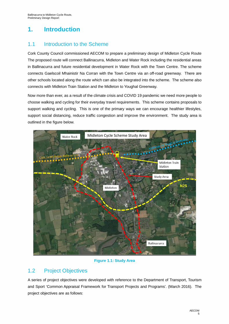
support social distancing, reduce traffic congestion and improve the environment. The study area is
outlined in the figure below.
Figure 1.1: Study Area
1.2 Project ObjectivesA series of project objectives were developed with reference to the Department of Transport, Tourism
and Sport ‘Common Appraisal Framework for Transport Projects and Programs’. (March 2016). The
project objectives are as follows:

Ballinacurra to Midleton Cycle Route,Preliminary Design Report
AECOM6
· To improve road safety at the junctions;
· To ensure value for money in the implementation of the proposals;
· To improve accessibility/ permeability within the study area for pedestrians, cyclists and publictransport users
· Functioning route for vehicular movement including public transport;
· Integration of scheme with other proposals and plans for the area;
· To reduce the negative impact of transport on the public realm.
Section 6 of this report accesses each of the design options against the project objectives highlightedabove.
1.3 Integration of other Relevant Schemes in the AreaThere are several other schemes in the area which have been considered as part of the preliminary
design process. These are outlined below.
1.3.1 Midleton to Youghal Greenway
Cork County Council are currently constructing a 23km greenway between Midleton and Youghal along
the disused railway line. This project will connect with the Ballinacurra to Midleton cycle route at
Midleton Train Station.
1.3.2 Charleston Residential Development
Planning permission has recently been granted for an 87-unit residential development on a greenfield
site between the R630 and the L3621 within the study area of the cycleway scheme. Integration and
connectivity between the schemes will be examined as part of this report.
1.3.3 Maple Woods Residential Development
Planning permission is currently being sought for residential units off the R630 to the south of the study
area for the cycleway scheme. Integration and connectivity between this development and the cyclewayscheme will be examined as part of this report.
1.4 Relevant Guidance and StandardsThe project has been designed with reference to the following guidance and standards:
· National Cycle Manual;
· Cork Metropolitan Area Transport Strategy 2040 (C-MATS)
· Cork Metropolitan Area Cycle Network Plan;
· Design Manual for Urban Roads and Streets;
· Design Manual for Roads and Bridges.
1.5 Purpose of this Preliminary Design ReportThe purpose of the report is to document the process undertaken to develop the proposed scheme.
Options have been developed that will look to address issues identified in the desktop analysis, site

Ballinacurra to Midleton Cycle Route,Preliminary Design Report
AECOM7
visits and policy objectives. One of these options will be selected for preliminary design and subsequent
detailed design/construction. For the purpose of the report the scheme will be split into two sections,
section one will be from Ballinacurra (Maple Woods entrance) to Midleton (Main Street) and fromMidleton (Main Street) to Water Rock and Train Station.
1.6 Other Relevant ReportsA separate Appropriate Assessment (AA) Screening report has been produced to inform CCC in relation
to Screening for AA required under the legislation included within Appendix B.
1.7 Structure of this Preliminary Design ReportThe Report is structured as follows:
Chapter 2 Identification of Need
This chapter outlines the need for the Cycle Route and how this project fits in the national, county and
local planning policy.
Chapter 3 Existing Conditions
Chapter 3 outlines the existing conditions within the scheme study area. This includes observations on
the current road and junction use and identification of existing constraints in the study area.
Chapter 4 Design Approach
This chapter outlines the general design approach used during the preliminary design of the scheme.
Chapter 5 Route Options
Chapter 5 outlines the options considered during the preliminary design of the projects as part of this
scheme.
Chapter 6 Identification of Preferred Route
This chapter identifies the preferred route of the scheme.
Chapter 7 Conclusions
This chapter concludes the report.

Ballinacurra to Midleton Cycle Route,Preliminary Design Report
AECOM8
2. Identification of Need
2.1 National Planning Policy
2.1.1 National Planning Framework & National Development Plan
The National Planning Framework (NPF) is the Government’s high-level strategic plan for shaping
future growth and development and was published in March 2018. The NPF sets out ten National
Strategic Outcomes (NSOs) which the framework aims to deliver.
A strategic investment priority under the National Development Plan 2018-2027 is public investment in
environmentally sustainable public transport systems in major urban areas, as a primary enabler for
National Strategic Outcomes under the NPF relating to compact growth.
National Strategic Outcome 1 – Compact Growth
The guiding principle is the integration of land use and transportation in order to create a sustainable
city. This can provide opportunities to reduce car dependency and allow for greater investment in
alternative means of travel including public transport, walking and cycling.
The proposal will link settlement areas with employment, shops and community and education facilities
and will allow for active sustainable travel to occur. The proposal will therefore help the integration of
land use and transportation and is seen as essential in creating sustainable living.
National Strategic Outcome 4 – Sustainable Mobility
The proposed scheme will assist in developing a comprehensive network of safe cycling routes toaddress the travel needs of its population. The cycle network will cater for all ages and abilities and will
allow for a range of cycling activities to occur, including commuting, leisure and tourism. The proposal
will improve the liveability and quality of life for the local population and will build on existing
infrastructure already in place and under construction.
2.1.2 National Cycling Policy Framework 2009-2020
In recognising cycling as one of the most important forms of sustainable transport the Department of
Transport published a National Cycling Policy Framework in April 2009. The policy frameworkemanates from the Government’s new transport policy for Ireland – 2009-2020 Smarter Travel –A
Sustainable Transport Future.
The framework sets out many policies and objectives in relation to cycling, with the aim of increasingcycling’s mode share from 2% to 10% by 2020.
· The key objectives of the policy framework are as follows:
· Move 160,000 people a day to work by bike; an increase of 125,000 people;
· Invest in better, safer cycle routes around the country for commuters,
· Leisure cyclists and visitors. (Improve existing cycle routes and introduce
Ballinacurra to Midleton Cycle Route,Preliminary Design Report
AECOM9
· New routes to best international standards);
· Increase cycling’s share of the total travel market, from 2% to 10%;
· Introduce a new approach to the design of urban roads to better
· Recognise the needs of cyclists and pedestrians; and
· Retrofit major road junctions and roadways in key cities and towns to make them cycle friendly.
The National Cycling Policy Framework 2009 – 2020 aims to create a strong culture of cycling in Ireland
with an aim that 10% of all trips will be by bike by 2020.
2.1.3 Smarter Travel – A Sustainable Transport Future, A new Transport Policy forIreland (2009-2020)
The Department for Transport, Tourism & Sport’s, Smarter Travel policy sets out a vision for how a
sustainable travel and transport system can be achieved. The strategy provides a framework to
incrementally change travel and transport system in Ireland to a more sustainable pattern.
2.2 County Planning Policy
2.2.1 County Development Plan
The County Development Plan sets out detailed Objectives under TM 2-2 (Cycling) which seek to
encourage and promote cycling as an important mode of travel. The objectives reflect national policy
as articulated in “Smarter Travel”:
Objective TM 2-2: Cycling
a) Encourage and facilitate a safe walking and cycling route network and a culture of walking and
particularly cycling in the county, as a viable alternative travel choice. Local Area Plans will set out Active
Travel Strategies (cycling and walking) for individual towns and their hinterlands.
b) Improve the streetscape environment for pedestrians, cyclists and those with special mobility needs
while seeking to provide facilities which enhance safety and convenience. The Design Manual for
Urban Roads & Streets (DMURS) is a useful guidance tool.
c) Ensure that development in urban areas, towns and villages is well located, permeable and prioritises
walking, cycling and access to public transport and other important amenities. The Design Manual for
Urban Roads & Streets (DMURS) is a useful guidance tool.
d) Promote the development of an integrated and coherent local and countywide cycle network to form
part of the wider National Cycle Network. Routes will be promoted which generally seek to avoid or
minimise impacts on the environment and on EU designated sites.
2.2.2 Cork Cycle Network Plan
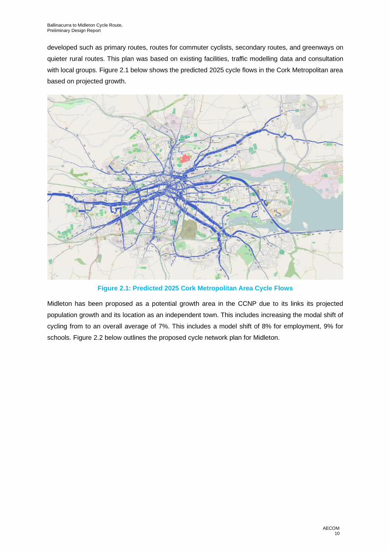
The Cork Cycle Network Plan (CCNP) was developed in 2017 as a means of building on the National
Cycle Plan by providing a detailed cycling infrastructure plan for Cork. This includes individual route
plans for the city centre and suburban areas such as Midleton. A hierarchy of cycle routes has been
Ballinacurra to Midleton Cycle Route,Preliminary Design Report
AECOM10
developed such as primary routes, routes for commuter cyclists, secondary routes, and greenways on
quieter rural routes. This plan was based on existing facilities, traffic modelling data and consultation
with local groups. Figure 2.1 below shows the predicted 2025 cycle flows in the Cork Metropolitan areabased on projected growth.
Figure 2.1: Predicted 2025 Cork Metropolitan Area Cycle Flows
Midleton has been proposed as a potential growth area in the CCNP due to its links its projected
population growth and its location as an independent town. This includes increasing the modal shift of
cycling from to an overall average of 7%. This includes a model shift of 8% for employment, 9% for
schools. Figure 2.2 below outlines the proposed cycle network plan for Midleton.

Ballinacurra to Midleton Cycle Route,Preliminary Design Report
AECOM11
Figure 2.2: Cork Cycle Network Plan, Midleton and Ballinacurra

Midleton Cycle Route,Preliminary Design Report
AECOM12
The R630 has been classified as a secondary route (M-U18) in the CCNP linking Ballynacurra in the
south with Midleton Town Centre in the north. The current plan has suggested adding mandatory cycle
lanes on each side of the carriageway.
Bailick Road is classified as two separate sections (M-U10 and M-U12) to account for sections north
and south of the N25. M-U12 is classified as the southern section and is proposed as a primary route
with a ‘mixed street’ environment and traffic calming measures to reduce traffic speeds. M-U10 covers
the northern section of Bailick Road and suggests similar measures to the M-U12. This also includes asuggestion to realign the junction of Bailick Road/Broderick Street on approach to the town centre. Both
sections recognise that this road has narrow cross sections and poor sight lines in some locations.
Rosary Place (M-U11) is also proposed as a primary route and for a ‘mixed street’ to service the schools
along the route.
Riverside Way, which forms the southern section of the study area is classified as a primary route (M-
U13) in the CCNP. The northern section, which runs adjacent to the Owenacurra River, is classified as
greenway (M-GW3).
Other routes are also identified; such as, a route to following the R626 Millbrook Crescent (M-U16),
identified as a primary route and routes that run to the east of Midleton Rail Station, through residential
areas (M-U5 /MU-3), also classified as primary routes.
M-U6 Castle Rock to Ballyannan is identified as a secondary route connecting Castle Rock residential
area with Ballyannan Woods and the Bailick Road.
2.3 Local Planning Policy
2.3.1 East Cork Municipal District LAP (2017)
The East Cork Municipal District LAP was published in 2017 and sets out the land use planning and
zoning for settlements in the region up to 2022. One of the key objectives for this plan is Traffic and
Transport which seeks to:
‘make Cork a more competitive county and foster sustainable economic and population growth through
the delivery of an efficient transport system and encourage balanced investment in less polluting and
more energy efficient modes of public and private transport, including walking and cycling. ‘
For Midleton, this includes a planned growth to 21,576 from a 2011 base of 12,001. To accommodate
this, development of the N25 and future relief road are planned to accommodate the expected
population and traffic growth in the area. This is to be complemented by identifying potential cycle
routes in the town centre. Furthermore, plans to improve bus services in north-south direction is alsoplanned.
Ballinacurra is identified as a potential growth suburb to the south of Midleton. This includes a potential
primary school and playground to complement existing services there.

Midleton Cycle Route,Preliminary Design Report
AECOM13
2.4 ConnectivityThe proposed route between Ballinacurra, Midleton and Water Rock connects a number of residential
developments with Midleton town centre as well as primary and secondary schools in the area. Figure
2.3 below highlights the residential, town centre and schools located within the study area.
An additional east / west connection is also proposed in order to link the route to both Midleton Rail
Station and the Youghal to Midleton Greenway.
.
Figure 2.3: Scheme Connectivity
2.4.1 Connectivity to Residential Zone
A number of residential zones are located within or near the study area for the proposed cycle track.
The scheme connects the village of Ballinacurra (population circa 3,000) with Midleton (population

Midleton Cycle Route,Preliminary Design Report
AECOM14
12,496 (2016 census)), the Water Rock Residential Masterplan Site and includes residential areas in
the south of the town.
There is also available land within the study area which is zoned for residential development. A planning
application was recently granted for the development of 89 residential units at Castleredmond, Dark
Road, Ballinacurra.
2.4.2 Connectivity to Schools
There are a number of secondary and primary schools located in the study area for the scheme. By
connecting the proposed scheme with local schools, this will promote cycling to and from school. This
has the potential to reduce traffic travelling to and from the schools in the area during the peak school
traffic periods.
Midleton Cycle Route,Preliminary Design Report
AECOM15
3. Existing Site Conditions
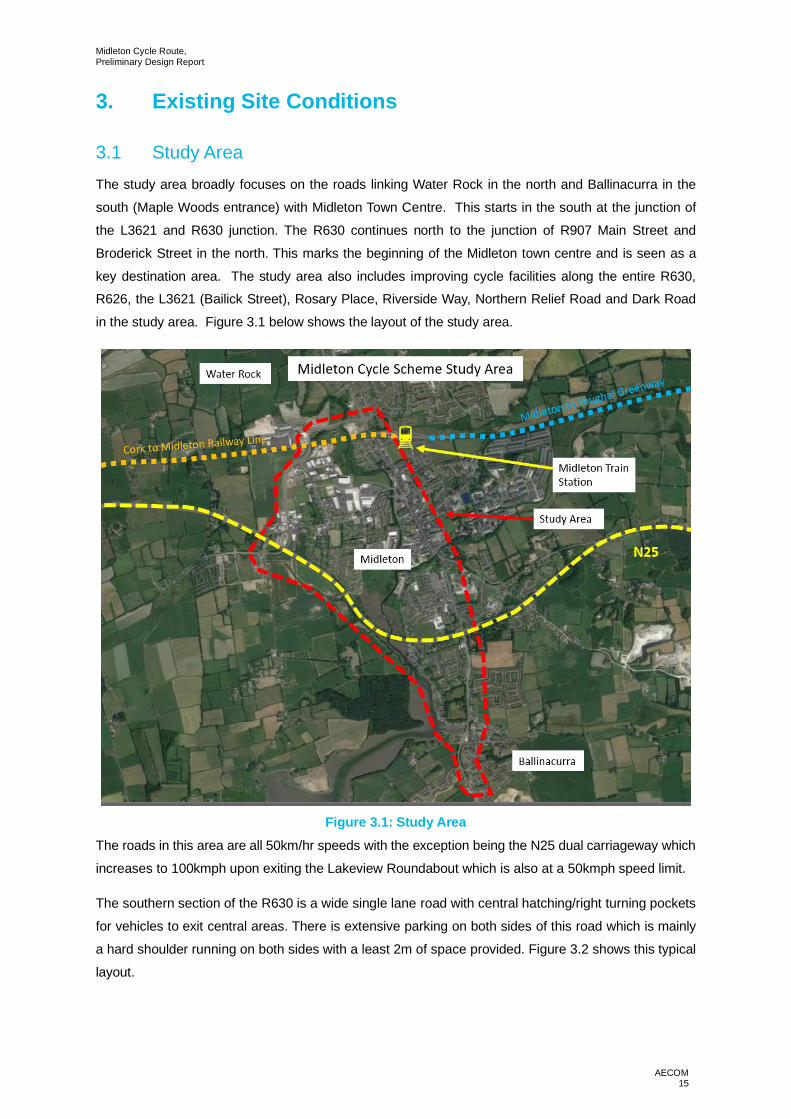
3.1 Study AreaThe study area broadly focuses on the roads linking Water Rock in the north and Ballinacurra in the
south (Maple Woods entrance) with Midleton Town Centre. This starts in the south at the junction of
the L3621 and R630 junction. The R630 continues north to the junction of R907 Main Street and
Broderick Street in the north. This marks the beginning of the Midleton town centre and is seen as a
key destination area. The study area also includes improving cycle facilities along the entire R630,R626, the L3621 (Bailick Street), Rosary Place, Riverside Way, Northern Relief Road and Dark Road
in the study area. Figure 3.1 below shows the layout of the study area.
Figure 3.1: Study AreaThe roads in this area are all 50km/hr speeds with the exception being the N25 dual carriageway which
increases to 100kmph upon exiting the Lakeview Roundabout which is also at a 50kmph speed limit.
The southern section of the R630 is a wide single lane road with central hatching/right turning pockets
for vehicles to exit central areas. There is extensive parking on both sides of this road which is mainly
a hard shoulder running on both sides with a least 2m of space provided. Figure 3.2 shows this typical
layout.

Midleton Cycle Route,Preliminary Design Report
AECOM16
Figure 3.2: Typical Layout of the R630 (south)The Lakeview Roundabout is a four-arm give way roundabout and is intersected by the N25 and the
R630. It also features a pedestrian bridge linking the northern and southern of the R630 for pedestrians.
To the north of Lakeview Roundabout, this road narrows considerably to one lane in each direction with
no central hatching and parking to the eastern side of the R630 carriageway. There is no parking on
western side as footways are already quite narrow. Figure 3.3 shows this typical layout.
Figure 3.3: Typical Layout of R630 (North)The R630 terminates at its junction with the R907 Youghal Road. This is a give-way T-junction with the
R907 continuing directly into Midleton Town Centre. This road consists of single lanes with an increase

Midleton Cycle Route,Preliminary Design Report
AECOM17
in traffic volumes. The road narrows on its way into Main Street where it passes over a bridge which
further reduces space for cyclists. There are numerous parking spaces in the town centre and some
underutilised space between car parking and the carriageway.
The L3621 Bailick Road runs to the west of the R630 outside most of the built-up area of Midleton.
However, there are some residential properties along this route and small businesses. This route also
provides an alternative access route to schools on Rosary Place. Bailick Road consists of a single lane
carriageway in each direction with some provision for pedestrians along this section. However, there isreduced forward visibility in some sections that creates a feeling of discomfort for pedestrians who
attempt to walk along both sides of the road or who wish to cross. Vehicle speeds along this section
were observed to be quite high and volumes not as high as on R630. Figure 3.4 shows the typical layout
of Bailick Road.
Figure 3.4: Layout and alignment of L3671 Bailick Road.
3.2 Key Network Constraints
3.2.1 Watercourses
There are two watercourses in the area. The first is a water inlet at the southern extents of the scheme
by Bailick Road. This previously served as a small harbour for loading freight but is now generallydisused. This watercourse leads south to Cork Harbour and is also joined by the River Owenacurra
from the north which runs to the east of Midleton Town. Figure 3.5 shows this disused harbour to the
south of Bailick Road. A tributary to the River Owenacurra intersects the L3671 Bailick Road, the
existing bridge over this tributary is not wide enough to accommodate upgraded cycling facilities and
vehicular traffic.
Midleton Cycle Route,Preliminary Design Report
AECOM18
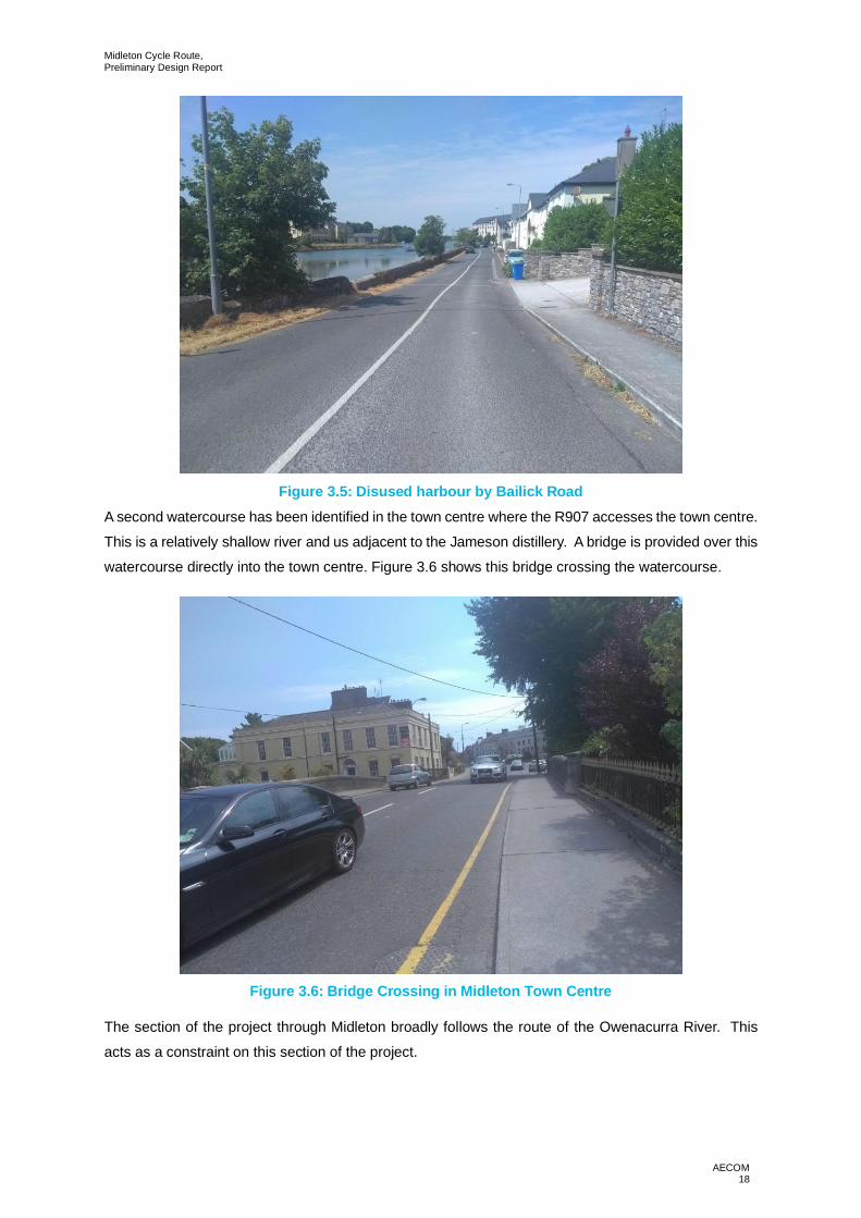
Figure 3.5: Disused harbour by Bailick RoadA second watercourse has been identified in the town centre where the R907 accesses the town centre.
This is a relatively shallow river and us adjacent to the Jameson distillery. A bridge is provided over this
watercourse directly into the town centre. Figure 3.6 shows this bridge crossing the watercourse.
Figure 3.6: Bridge Crossing in Midleton Town Centre
The section of the project through Midleton broadly follows the route of the Owenacurra River. This
acts as a constraint on this section of the project.

Midleton Cycle Route,Preliminary Design Report
AECOM19
3.2.2 Flooding
An analysis of the Office of Public Works (OPW) flood hazard maps website has been undertaken toidentify the history of flooding in vicinity of the proposed scheme. The website indicates that there is
some history of flooding in the study area. There have been three flood incidents in the town centre in
the past three years. A flood protection scheme for Midleton is currently in the planning process. The
design team have been in contact with the flood protection design team to ensure that the two projects
integrate with one another.
3.2.3 Topographical Constraints
Gradient acts as a constraint on the design. Where Bailick Road intersects the R630 there is anincrease in gradient at the junction. This may impact the route choice for cyclists, Bailick Road is a
longer route into the centre of Midleton but is flatter and an easier cycle. The R630 changes in gradient
on both the north and south side of the Lakeview roundabout. Therefore, any cyclist looking to exit the
roundabout on the north and south would have to climb a hill slightly. Rosary Place has an increase in
gradient from Bailick Road towards the R630; this may also influence route choice of potential cyclists.
In terms of horizontal alignment, sections of Bailick Road vary in width, limiting the forward visibility and
safe space for both cyclists and passing traffic to occupy at various locations.
Figure 3.7: Increase in Gradient from Bailick Road to R630
3.2.4 Land Use
The proposed study area is mainly comprised of residential housing with occasional businesses located
along the routes. Three schools are located within on Rosary Place with a further two located to the
east of the R630. School journeys will be key to developing increased cycle trips in the area, the new
facilities will provide safe and reliable cycle facilities to encourage the uptake of cycling.

Midleton Cycle Route,Preliminary Design Report
AECOM20
The town centre is located on the northern extents of the study and has typical mix of shops, cafes and
local businesses. The Jameson distillery and local tourist office is located to the east of the town and
would be a potential link for cyclists, particularly tourists. The train station is located on the northernend of the town, away from the study area but could be a potential future trip attractor for cyclists. A
bike repair shop is located within Midleton Town but is not clearly signposted and is away from the town
centre.
There is also a park and greenspace located to the west of the Bailick Road that provides a local amenityoverlooking the river Owenacurra. Running tracks and sports pitches are located to the north of the N25
although this is currently private usage for schools with no access from the N25.
3.2.5 Existing Structures
There are five prominent structures along the route. The first is a bridge structure that runs across the
L3621, carrying the N25 dual carriageway. Bailick Road narrows slightly as it approaches the structure
with one footway provided underneath the structure for pedestrians. There is no lighting on one half of
the structure which may be a safety issue during darker months. Figure 3.8 shows the structure asviewing from Bailick Road.
Figure 3.8: N25 Underbridge
The second structure is a pedestrian bridge that runs across the Lakeview roundabout in a north-south
direction parallel to the R630. It has an approximate width of 1.8m for pedestrians and would be too
narrow to accommodate both cyclists and pedestrians. Dropped kerbs are also provided at ground level
adjacent to the structure with some pedestrians being observed using this crossing rather than the
bridge. Figure 3.9 shows this bridge crossing the N25.

Midleton Cycle Route,Preliminary Design Report
AECOM21
A third structure that may influence future designs will be the bridge crossing the Owenacurra into
Midleton town. While not as restricting as the first two structures, there will be a constraint on lane
widening to accommodate any increase in cycle lanes and footways. Figure 3.10 shows the layout ofthis bridge. A narrow bridge exists on the Bailick Road; it crosses a tributary of the Owenacurra River.
The existing bridge would not be able to accommodate increased additional width for pedestrians or
cyclists. Bridge would require widening or an alternative crossing would be required. Figure 3.11
highlights the bridge.
A protected bridge (see section below for description) crosses the Owenacurra River adjacent to
Riverside Way. The existing bridge is wide with footways on both sides therefore it won’t act as a major
constraint on the design.
Figure 3.9: Lakeview Roundabout Pedestrian Bridge

Midleton Cycle Route,Preliminary Design Report
AECOM22
Figure 3.10: Bridge Crossing into Midleton Town Centre
Figure 3.11: Bridge Crossing Over Tributary of the Owenacurra River
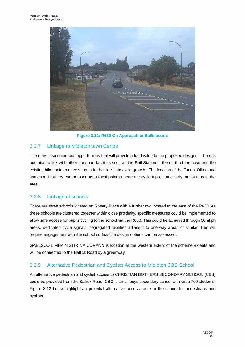
3.2.6 R630 Carriageway Width
The existing carriageway width of the R630 provides opportunity to incorporate cycle infrastructure
within the existing cross section without impacting he vehicular capacity of the road or impacting
negatively on parking in the area. Cycle infrastructure on the road would act as a traffic calming measure
as it would reduce the available road width therefore reducing vehicle speeds.
Midleton Cycle Route,Preliminary Design Report
AECOM23
Figure 3.12: R630 On Approach to Ballinacurra
3.2.7 Linkage to Midleton town Centre
There are also numerous opportunities that will provide added value to the proposed designs. There is
potential to link with other transport facilities such as the Rail Station in the north of the town and the
existing bike maintenance shop to further facilitate cycle growth. The location of the Tourist Office and
Jameson Distillery can be used as a focal point to generate cycle trips, particularly tourist trips in the
area.
3.2.8 Linkage of schools
There are three schools located on Rosary Place with a further two located to the east of the R630. As
these schools are clustered together within close proximity, specific measures could be implemented to
allow safe access for pupils cycling to the school via the R630. This could be achieved through 30mkph
areas, dedicated cycle signals, segregated facilities adjacent to one-way areas or similar. This will
require engagement with the school so feasible design options can be assessed.
GAELSCOIL MHAINISTIR NA CORANN is location at the western extent of the scheme extents and
will be connected to the Ballick Road by a greenway.
3.2.9 Alternative Pedestrian and Cyclists Access to Midleton CBS School
An alternative pedestrian and cyclist access to CHRISTIAN BOTHERS SECONDARY SCHOOL (CBS)
could be provided from the Bailick Road. CBC is an all-boys secondary school with circa 700 students.
Figure 3.12 below highlights a potential alternative access route to the school for pedestrians and
cyclists.

Midleton Cycle Route,Preliminary Design Report
AECOM24
Figure 3.13: Alternative Pedestrian and Cyclists access to CBS Midleton
The alternative access would aim to relieve some of the congestion at the main access to the school,
which occurs during the AM and PM peaks. The proximity of the access may be an issue however, as
the proposed access runs adjacent to the N25. Further consultation with the National Transport
Authority (NTA) and CBS Midleton is required to determine the feasibility of the new link to the school.
3.2.10 Railway Infrastructure
The Cork to Midleton railway line runs through the project to the north of the scheme extents. Measures
to support permeability will be required to connect Midleton Town Centre with the Water Rock
Masterplan Site.
3.2.11 Protected Structures
There are numerous protected structures along the proposed route, they include the following:
· Oikoseen House on the L3671 Bailick Road is a listed structure. The National Monument services
describes the item as: “Detached L-plan four-bay two-storey former house, built c. 1800, having
double-pitch full-height return to east end of rear (north) elevation, and with oriel window and
canted bay window, both with artificial slate hipped roofs, to east elevation. Now in use as offices.
Pitched slate and artificial slate roofs with rendered chimneystacks. Rendered walls. Camber-
headed openings with six-over-six pane timber sliding sash windows and timber panelled door with
plain overlight to front elevation, and with six-over-six, four-over-four and two-over-four pane timber
sliding sash windows to east and west elevations. Square-headed openings with timber sliding
sash windows, having six-over-six, four-over-four, two-over-two, and one-over-one panes to east,
west and rear elevations, and replacement uPVC window to west elevation. Fixed timber framed
windows to oriel window. Round-headed door opening with half-glazed timber panelled door and

Midleton Cycle Route,Preliminary Design Report
AECOM25
spoked fanlight to east elevation. Render plinth wall and square-profile piers to front boundary,
having replacement metal gates and railings”. The registration number is: 20907626.
· The Charleston Apartments form part on a listed building on the L3671 on Bailick Road. TheNational Monument services describes the item as: “Detached complex U-plan nineteen-bay five-
storey former malt house, dated 1798, 1902 and 1924, having two-bay three-storey gabled return
to front (south) elevation, twelve-bay five-storey east side elevation having four gables forming M-
profile roof, nine-bay four-storey west side elevation having three gables forming M-profile roof,
square-headed courtyard opening to centre, four-bay four-storey north elevation to block to north-
west, and five-bay four-storey north elevation to east block, having attic accommodation with
lanterns. Oriel windows to south, east and north elevations, balconies to south, west, and north
elevations. Now in use as apartment block. Pitched and hipped artificial slate roofs. Dressed
limestone walls with dressed quoins to east elevation and to north elevation of east block.
Rendered walls to south, west, and courtyard elevations. Segmental-headed openings with red
brick block-and-start surrounds and voussoirs to east elevation and north elevation of east block.
Square-headed openings to south and west elevations, all openings with replacement windows
and doors. Sandstone dated keystone to east elevation and to footpath to south. Multiple-bay two-
storey house to north of site having artificial slate roof, rendered and rubble stone walls, square-
headed openings and round-headed carriage arch with red brick voussoirs, all with replacement
fittings. Multiple-bay two-storey building to east of site having barrel roof, rubble stone walls with
red brick quoins, and square-headed openings with red brick surrounds and voussoirs”. The
registration number is: 20907627.
· North of the junction between L3671 Bailick Road and Dark Road there is a warehouse. The
National Monument services describes the item as: “Detached triple-pile four-bay four-storey store,
built c. 1800, having three parallel blocks running east-west, and single-storey flat-roofed extension
to west elevation. Now disused. Pitched corrugated-iron and corrugated metal roofs with sheet
metal vents. Rendered rubble stone walls, slate-hung to north elevation. Square-headed window
openings. Square-headed door openings, having timber battened door to first floor central gable
to west, and sheet metal sliding door to south gable to west. Several recent circular-plan silos to
site. Rubble stone boundary walls, buttressed to east, and with square-profile concrete block piers
with sheet metal gates to west of site”. The registration number is: 20907624.
· North of the junction between L3671 Bailick Road and Dark Road there is a house. The NationalMonument services describes the item as: “Detached six-bay single-storey house, built c. 1810.
Pitched tiled and artificial slate roof with rendered chimneystacks. Rendered walls. Square-headed
openings with render surrounds having two-over-two pane timber sliding sash windows and timber
panelled door.”. The registration number is: 20907623.
· At the entrance to Cherrywood Estate on the there is a freestanding vent pipe. The NationalMonument services describes the item as: “Freestanding circular-profile vent pipe, erected c. 1870,
having cast-iron fluted and banded base, fibre shaft, and cast-iron decorative cowling”. The
registration number is: 20907622.

Midleton Cycle Route,Preliminary Design Report
AECOM26
· Cork Bridge, Oatenacke. The National Monument services describes the item as: “Five-arch
limestone road bridge over the Owenacurra River, built c. 1810, having U-cutwaters to north
elevation. Snecked walls to north elevation having plat band and rounded copings to parapet walls.
Cut limestone voussoirs to round-headed openings. Square-profile piers to parapet walls having
recessed panels. Recently widened to south elevation, with concrete addition. Limestone steps
with parapet walls to south elevation”. The registration number is: 20830013.
3.2.12 Protected Structures to be Included in Next Revision of RMP
· On the site of the Moornings Apartment Block. Historic Environment describes the item as: “On E
bank of tidal stretch of Owenacurra river; marked 'site of' on 1842 OS 6-inch map; no visible surface
trace. Fitzgerald castle, reputedly built in the 15th century (Healy 1988, 120-1)”.
· On the site of O’Farrell’s Funeral Home adjacent to Kennedy Park. Historic Environment describes
the item as: “In Midleton, on E bank of Owenacurra River. Remains of late 19th century gasworks
complex. Marked on 1902 and 1934 OS 6-inch maps. According to local information, closed in
1950s, converted to Midleton Foundry and Engineering Works which was in operation until
recently. Main block of buildings consists of a wide gable-ended structure (long axis N-S) with
chimney on N gable; limestone quoins. Photograph taken in 1953 (O'Sullivan 1987, 17) shows
condenser, washer and scrubber along S external elevation. Little remains except a few iron
troughs and hoists. Attached to E is similar but slightly higher and long to N, wide gable ended
structure sharing limestone quoins of structure to W; brick quoins elsewhere. Both buildings have
brick detail to opes. Attached to N gable and extending W is one-storey structure. Photograph also
hsows lean-to structure along S of building running E-W housing the purification machinery (no
longer survives). Overgrown remains of two circular gas holders (diam 9.7m) defined by earthen
bank which retains wall along inner edge (int. H 1.5m; Wth 2m). Stone wall along S side of complex
with entrance gates at E end. Remains of office (long axis E-W) adjacent to S. One-storey work
shop (long axis N-S) to W with remains of gas holders on either side”.
Midleton Cycle Route,Preliminary Design Report
AECOM27
4. Design Approach
4.1 Design Guidance/StandardsDesign Guidance and Standards used have been outlined in Section 1.4.
4.2 Cross SectionsThe new road cross sections were developed referencing the design standards specified. A number of
measures to improve cyclist facilities at junctions were identified and incorporated consistentlythroughout the project.
4.3 Carriageway WidthDMURS has a dedicated chapter providing guidance on road widths depending on the road type. Thishighlight that designers should minimise the width of the carriageway by incorporating only as many
lanes as needed to cater for projected vehicle flows and by reducing the size of individual lanes to meet
predominant user needs. Each project was assessed on an individual basis. The width of the vehicular
lanes varies between 3m and 3.5m depending on the location.
4.4 Footway/Footpath ProvisionDMURS recommends a minimum footway/footpath width of 1.8m. Minimum widths are based on the
space needed for two wheelchairs to pass each other. The minimum footway/footpath width is generally
2m for all of the proposed projects. Where a pinch point exists on the network the width may reduce to
1.8m but only if no other solution was viable.
4.5 Cycling ProvisionThe National Cycle Manual was used to determine the type of cycle facility required for the new road.
This recommends that designers should ‘Determine the design speeds and volumes of traffic according
to the regional and/or local sustainable traffic plan and provide the appropriate cycling facility for that
regime’. Generally; the cycle lane width will be a minimum of 1.75m.
4.6 Corner RadiiDMURS recommend reducing corner radii to improve pedestrian safety at junctions. It lowers the speed
at which vehicles can turn corners and increases inter-visibility for all road users. Where design speedsare low and movements by larger vehicles are infrequent, a maximum corner radius of 1-3m can be
applied.
4.7 Pedestrian CrossingsDMURS outlines pedestrian crossings are one of the most important aspects of street design as it is at
this location that most interactions between pedestrians, cyclists and motor vehicles occur. Well
designed and frequently provided crossings are critical to the balancing of movement priorities. The
Midleton Cycle Route,Preliminary Design Report
AECOM28
location and frequency of crossings should align with key desire lines and be provided at regular
intervals.
4.8 DrainageThe existing drainage consists of an ‘over the edge’ system where it percolates trough the existing
ground or a ‘kerb and gully’ system where it connects to a drainage network and outfalls to the receiving
environment. The proposed drainage system will replicate the existing drainage system for the project.
In order to facilitate the efficient collection of surface water new gullies will be provided in accordancewith DN-DNG-03067. To achieve a compliant design ensuring comfort for the end user, gullies will be
provided at the correct spacing to ensure the maximum flow width is achieved, upstream of all
pedestrian crossings to ensure the end user isn’t stepping onto a stream of water and double gullies at
low points in the carriageway to ensure water does not collect a key locations. The drainage will be
designed in accordance with the following design standards and specification:
· DN-DNG-03067 – Spacing of Road Gullies,
· CC-SPW-00500 – Specification for Road Works Series 500 - Drainage and Service Ducts.
4.9 PavementPavement will be designed in compliance with TII Standards. The process will start with the
consideration of the cumulative traffic loading which the pavement is required to carry, followed by the
design of the foundation, the base or main structural component and the surface course.
4.10 LightingThe lighting design will be produced in accordance with Cork County Council Public Lighting Manual
and Product Specification 2018. The document highlights the statutory design specification and Cork
County Councils requirements for consistent products across the County. ‘Lighting Reality’ software willbe used to produce the lighting design.
4.11 Traffic Signs and Road MarkingsTraffic signs and road markings will be reviewed and confirmed as part of the detail design packageand they will be designed in compliance with the Traffic Signs Manual (2010). Junction layouts have
been outlined in the preliminary design drawings.
4.12 BridgesBridges will be designed in line with the requirements contained within the TII publication Design Manual
of Roads and the Eurocode Standards, as transposed in the Irish National Standards and Annexes, the
National Cycle Manual and the Design Manual for Urban Roads and Streets (DMURS).

Midleton Cycle Route,Preliminary Design Report
AECOM29
4.13 Railway Line UnderpassThe underpass required for the railway line will be designed in line with the requirements contained
within the TII publication Design Manual of Roads and the Eurocode Standards, as transposed in the
Irish National Standards and Annexes, the National Cycle Manual and the Design Manual for Urban
Roads and Streets (DMURS). Initial consultation with Irish Rail regarding interaction of the project and
their infrastructure was positive, a report was issued highlighting the benefits of the project to
pedestrians, cyclists, commuters and the wider community.

Midleton Cycle Route,Preliminary Design Report
AECOM30
5. Route OptionsFor the purpose of the route options assessment the project split into separate sections to analyse the
optimum route for each. Section 1 extends from Ballinacurra (Maple Woods entrance) to Midleton,Section 2 extends from Midleton to the Water Rock Development and Midleton Train Station.
5.1 Section 1 - Ballinacurra (Maple Woods entrance) to Midleton
5.1.1 Option 1-R630 Direct Route
· Segregated cycle track on eastern side of the R630 between Ballinacurra and Lakeview
Roundabout.
· Traffic calming of the R630 (St Marys Road) between Lakeview Roundabout and the centre of
Midleton along St Marys Road (R630). Insufficient width to incorporate dedicated cycling facilities.
· Upgrade of the existing pedestrian bridge to accommodate pedestrians and cyclists.
· Shared use path along Dark Road, linking Bailick Road and R630.
· Traffic calming of Rosary place to provide safer links to CHRISTIAN BROTHERS SCHOOL AND
ST MARYS HIGH SCHOOL.
· Wayfinding and cycle parking.
Figure 5.1: Section 1 - Option 1

Midleton Cycle Route,Preliminary Design Report
AECOM31
5.1.2 Option 2 – L3621 Bailick Road
· Segregated 1.8m one-way cycle tracks on either side of the R630 between Ballinacurra andLakeview Roundabout.
· Traffic calming and reduction of carriageway width of the R630 between Ballinacurra and Lakeview
Roundabout.
· One-way vehicular system on the Bailick Road between Bailick Road/R630 junction and the DarkRoad / Bailick Road junction.
· Combination of Segregated shared use path and a segregated cycleway along Bailick Road, one
way between Bailick Road/R630 junction and the entrance to the Charleston Warf Apartments.
· Shared vehicular and cyclists’ roads between Bailick Road/Dark Road junction and N25underbridge with one raised tables as traffic calming measures.
· 3m shared use path along Dark Road, linking Bailick Road and R630.
· Land acquisition to enable widening and improved horizontal alignment of the Bailick Road.
· Improved Lighting at N25 underbridge.
· 3m segregated shared path along Bailick Road from N25 underpass to town centre.
· Wayfinding and cycle parking.
· A new bridge is required on the L3621 Bailick Road over the tributary to the River Owenacurra.The proposal is to construct an independent bridge adjacent to the existing.
Figure 5.2: Section 1 - Option 2

Midleton Cycle Route,Preliminary Design Report
AECOM32
5.1.3 Option 3 – R630 and L3621 Bailick Road
· 2m segregated cycle track on both sides of the road along the R630 between Ballinacurra and
Lakeview Roundabout.
· Upgrade of the existing pedestrian bridge to accommodate pedestrians and cyclists.
· 3m shared use path parallel to the N25 to connect the north side of Lakeview Roundabout to BailickRoad.
· 3m segregated shared path along Bailick Road from N25 underpass to town centre.
· 3m shared use path along Dark Road, linking Bailick Road and R630.
· Traffic calming of Rosary place to provide safer links to Christian Brothers School and St Marys
High School.
· Wayfinding and cycle parking.
Figure 5.3: Section 1 - Option 3
Midleton Cycle Route,Preliminary Design Report
AECOM33
5.2 Section 2 - Midleton to Water Rock and Train Station
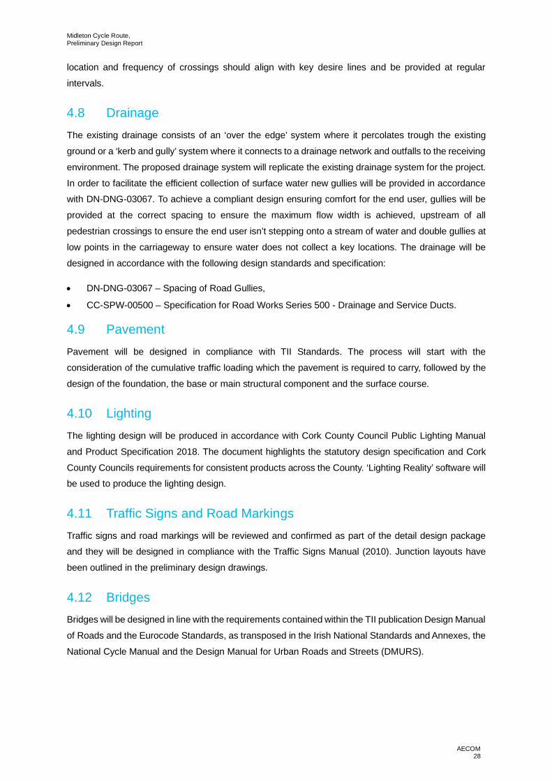
5.2.1 Option 1 – Riverside Way
· Shared Use path along Riverside Way adjacent to Owenacurra River.
· Toucan crossing at the Riverside Way / Church Street junction with widened footpaths where
possible.
· Cycle Parking facilities to be provided on Riverside Way.
· Crossing location to be provided on New Cork Road.
· Footpath widened to shared use path around roundabout.
· Off-road greenway to be provided on western side of the Owencurra River between Midleton retailPark and the Northern Relief Road.
· Underpass to be constructed at the crossing of the Cork to Midleton Railway line.
· Toucan Crossing to be provided on Northern Relief Road to connect route with Water Rock
Masterplan site.
· Cycle lanes on Northern Relief Road to be widened to allow for two directional cycling.
· Footpath widened on R626 to shared use path to connect to Midleton Rail Station and Midleton to
Youghal Greenway.
Figure 5.4: Section 2 - Option 1

Midleton Cycle Route,Preliminary Design Report
AECOM34
5.2.2 Option 2 – Riverside Way
· Shared Use path along Riverside Way adjacent to Owenacurra River.
· Toucan crossing at the Riverside Way / Church Street junction with widened footpaths where
possible.
· Cycle Parking facilities to be provided on Riverside Way.
· Crossing location to be provided on New Cork Road.
· Footpath widened to shared use path around roundabout.
· Off-road greenway to be provided on western side of the Owencurra River.
· Bridge to be provided to cross Owenacurra River to connect with Millbrook Lawn.
· Toucan Crossing to be provided on Northern Relief Road to connect route with Water Rock
Masterplan site.
· Footpath widened on R626 to Shared Use Path.
· Toucan Crossing to be provided on Northern Relief Road to connect route with Water Rock
Masterplan site.
· Cycle lanes on Northern Relief Road to be widened to allow for two directional cycling.
Figure 5.5: Section 2 - Option 2
Midleton Cycle Route,Preliminary Design Report
AECOM35
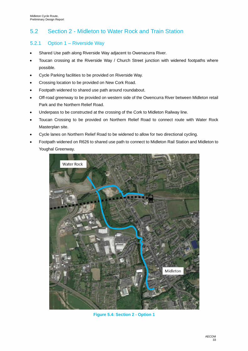
5.2.3 Option 3 – Riverside Way
· Shared Use path along Riverside Way adjacent to Owenacurra River.
· Toucan crossing at the Riverside Way / Church Street junction with widened footpaths where
possible.
· Cycle Parking facilities to be provided on Riverside Way.
· Crossing location to be provided on New Cork Road.
· Upgrade to existing ‘through-about’ and crossings at the roundabout.
· On-street ‘quiet’ routes along Lourdesville Estate / Michael Collins Square / McSweeney Terrace.
Traffic calming measures to be provided to reduce vehicular speeds.
· Additional section of greenway, with a minimum width of 3m, spurring from the proposed Midleton
to Youghal Greenway.
· Footpath widened on R626 to Shared Use Path.
· Toucan Crossing to be provided on Northern Relief Road to connect route with Water RockMasterplan site.
· Cycle lanes on Northern Relief Road to be widened to allow for two directional cycling.
Figure 5.6: Section 2 - Option 3

Midleton Cycle Route,Preliminary Design Report
AECOM36
6. Identification of Preferred Route
6.1 IntroductionIt was important that each of the options was assessed in a consistent and comprehensive manner to
establish which of the options delivered on the project objects. Options were identified for the project;
an assessment was carried out to assess the options against each other in relation to the project
objectives assessment criteria.
6.2 Project Objectives Assessment CriteriaA series of project objectives have been developed with reference to the Department of Transport,
Tourism and Sport ‘Common Appraisal Framework for Transport Projects and Programmes’ (March
2016). The project objectives are as follows:
· To improve road safety at the junctions,
· To ensure value for money in the implementation of the proposals,
· To improve accessibility/ permeability within the study area for pedestrians, cyclists and publictransport users,
· Functioning route for vehicular movement including public transport,
· Integration of scheme with other proposals and plans for the area,
· To reduce the negative impact of transport on the public realm.
Where an option assessment was required, each of the options was rated against the project objective
assessment criteria using the below option rating table. The options were then compared against one
another to determine the most favourable option.
Appraisal Criteria Scoring
Highly Positive
Moderately Positive
Slightly Positive
Neutral
Slightly Negative
Moderately Negative
Highly NegativeTable 6.1 Option Rating Table

Midleton Cycle Route,Preliminary Design Report
AECOM37
6.3 Section 1 - Option Assessment
6.3.1 Option 1
Criteria Project Objective Assessment of OptionCriteriaScore
SafetyTo improve roadsafety at thejunctions
The proposed option, with a combination of segregatedcycle tracks and traffic calming measures improves thesafety of cyclists within the study area
Economy
To ensure value formoney in theimplementation ofthe proposals
The proposed option will require a pedestrian andcyclist bridge to connect either side of the N25. Theexisting bridge is 1.75m wide which is too narrow forpedestrians and cyclists.
Accessibility& SocialInclusion
To improveaccessibility/permeability withinthe study area forpedestrians, cyclistsand public transportusers
The proposed route would improve the accessibility/permeability for cyclists in the area. As it is the mostdirect route of the three options it is given the mostfavourable score on this objective.
Functioning route forvehicular movementincluding publictransport
The proposed route will have a minimal impact on thecapacity of the existing road. Turning lanes on the R630will be removed as they are currently underutilised andare an inefficient use space. Roadside parking will beaffected by this proposed route north of the LakeviewRoundabout.
Integration
Integration ofscheme with otherproposals and plansfor the area
The scheme integrates with the proposed BallincurraR630 road improvement works project.
Environment
To reduce thenegative impact oftransport on thepublic realm
The proposed scheme will encourage more sustainabletransport in the area, reducing the number of journeysundertaken by private vehicles. This in turn decreasesthe amount of harmful emissions being released intothe atmosphere.
Midleton Cycle Route,Preliminary Design Report
AECOM38
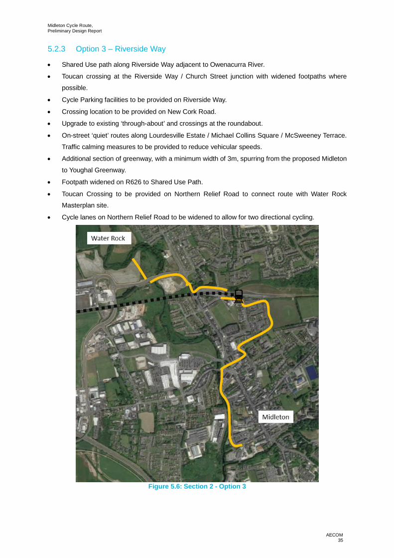
6.3.2 Option 2
Criteria Project Objective Assessment of OptionCriteriaScore
SafetyTo improve roadsafety at thejunctions
A combination of segregated cycle routes, road re-alignment and shared pedestrian and cyclist pathsimprove the safety of cyclists in the area. Introducing aone-way system on the Bailick will improve the safetyof the Bailick Road / R630 junction.
Economy
To ensure value formoney in theimplementation ofthe proposals
The proposed option will require the construction ofsegregated cycle infrastructure and cycle andpedestrian shared use infrastructure. This option willalso require land acquisition to widen the Bailick RoadCross Section where appropriate and to improve thehorizontal alignment of the Bailick road. A 10mpedestrian bridge or extension of the existing bridge isrequired on Bailick Road.
Accessibility& SocialInclusion
To improveaccessibility/permeability withinthe study area forpedestrians, cyclistsand public transportusers
The proposed route would improve the accessibility/permeability for cyclists in the area connectingresidential areas in Ballinacurra and Midleton to localschools and Midleton town centre.
Functioning route forvehicular movementincluding publictransport
The proposed route will affect the existing vehicularmovement along the south of the Bailick Road and theDark Road where a one-way system is proposed.
Integration
Integration ofscheme with otherproposals and plansfor the area
The scheme integrates with the proposed BallincurraR630 road improvement works project.
Environment
To reduce thenegative impact oftransport on thepublic realm
The proposed scheme will encourage more sustainabletransport in the area, reducing the number of journeysundertaken by private vehicles. This in turn decreasesthe amount of harmful emissions being released intothe atmosphere.

Midleton Cycle Route,Preliminary Design Report
AECOM39
6.3.3 Option 3
Criteria Project Objective Assessment of OptionCriteriaScore
SafetyTo improve roadsafety at thejunctions
The proposed route offers a combination of segregatedcycle track, cycle quietways, and shared-use cycle andpedestrian footways. The proposed route providessafer infrastructure for cyclists in the area.
EconomyTo ensure value formoney in theimplementation ofthe proposals
The proposed route can operate initially without theconstruction of a pedestrian and cycle bridge as analternative route can be utilised. The N25 corridor iscurrently under review by Cork County Council, if theN25/R630 junction were to be upgraded in the future anupgrade of the existing cycle / footbridge could belooked at as part of the scheme.
Accessibility& SocialInclusion
To improveaccessibility/permeability withinthe study area forpedestrians, cyclistsand public transportusers
The proposed route would improve the accessibility/permeability for cyclists in the area connectingresidential areas in Ballinacurra and Midleton to localschools and Midleton town centre. This option is lessfavourable than the other options in this category as itprovides the least direct route between Ballinacurra andMidleton.
Functioning route forvehicular movementincluding publictransport
The proposed route will have a minimal impact on thecapacity of the existing road. Turning lanes on the R630will be removed as they are currently underutilised andare an inefficient use space.
Integration
Integration ofscheme with otherproposals and plansfor the area
The scheme integrates with the proposed BallincurraR630 road improvement works project.
Environment
To reduce thenegative impact oftransport on thepublic realm
The proposed scheme will encourage more sustainabletransport in the area, reducing the number of journeysundertaken by private vehicles. This in turn decreasesthe amount of harmful emissions being released intothe atmosphere.

Midleton Cycle Route,Preliminary Design Report
AECOM40
6.3.4 Section 1 - Summary Table
Criteria Project Objective Option 1 Option 2 Option 3
Safety To improve road safety atthe junctions
Economy
To ensure value for money
in the implementation of
the proposals
Accessibility &
Social Inclusion
To improve accessibility/permeability within the
study area for pedestrians,
cyclists and public
transport users
Functioning route for
vehicular movement
including public transport
Integration
Integration of scheme with
other proposals and plansfor the area
EnvironmentTo reduce the negativeimpact of transport on the
public realm
Position 3rd 1st 2nd
6.4 Section 1 - Preferred OptionOption 2 has been identified as the preferred option following the assessment of each of the options
against the project objectives. Appendix A provides the preliminary design drawings for the preferred
option.

Midleton Cycle Route,Preliminary Design Report
AECOM41
6.4.1 Preferred Option Summary
· Segregated 1.8m one-way cycle tracks on either side of the R630 between Ballinacurra andLakeview Roundabout.
· Traffic calming and reduction of carriageway width of the R630 between Ballinacurra and Lakeview
Roundabout.
· One-way vehicular system on the Bailick Road between Bailick Road/R630 junction and the DarkRoad / Bailick Road junction.
· Combination of Segregated shared use path and a segregated cycleway along Bailick Road one
way between Bailick Road/R630 junction and the Dark Road/Bailick Road junction.
· Shared vehicular and cyclists’ roads between Bailick Road/Dark Road junction and N25underbridge with two raised tables as traffic calming measures.
· 3m shared use path along Dark Road, linking Bailick Road and R630.
· Land acquisition to enable widening and improved horizontal alignment of the Bailick Road.
· Improved Lighting at N25 underbridge.
· 3m segregated shared path along Bailick Road from N25 underpass to town centre.
· Wayfinding and cycle parking.
6.4.2 Preferred Route – Protected Structure Impact
As a result of the preferred route there is a requirement to remove a section of the wall in front of theprotected Warehouse (Registration Number 20907624) on L3621 Bailick Road. The section of
carriageway creates a dangerous pinch point on the route and there is no existing pedestrian or cycling
facilities on either side of the carriageway. Figure 6.1and 6.2 below highlight the existing situation.
Figure 6.1: L3621 Pinch Point (northbound)

Midleton Cycle Route,Preliminary Design Report
AECOM42
Figure 6.2: L3621 Pinch Point (southbound)(image taken from Google Maps)
The section of carriageway is located between two protected structures, a Warehouse (RegistrationNumber 20907624) and a House (Registration Number 20907623). The proposed route provides a 3m
shared use facility of the western side of the carriageway. the existing structure will remain in its current
position and a minor pinch will be provided in the shared use path to accommodate the structure. Given
the highly constrained area, the proposed solution is the least impactful on the existing protected
structures. The benefits of the proposed solution include:
· Improved road safety for pedestrians and cyclists. The existing L3621 Bailick Road doesnot accommodate pedestrians or cyclists and the location of the existing wall does not allow for
road widening. The proposed solution provides a 3m shared use path on Bailick Road to ensure
pedestrians and cyclists can travel safely. The image highlighted above shows the need for
pedestrian and cycling facilities as a woman is walking her dog on the road where there is
limited forward visibility.
· Improved road safety for vehicular traffic. The existing wall is a barrier to providing forwardvisibility for vehicular traffic. The proposed solution provides a 6m carriageway with a 3m shared
use path that will improve forward visibility making Bailick Road a safer place to drive, cycle
and walk. The image highlighted above shows the existing wall acting as a barrier to achieving
forward visibility.
Cork County Council have engaged with the owner of the property to determine a solution that is
acceptable to all parties. The initial consolation has progressed with the landowner however further
consultation is required throughout the project stages. All statutory requirements and permissions will
be achieved prior to removal of the boundary wall.
The preferred route will also impact the Freestanding Vent Pipe (Registration Number 20907622) at the
entrance to the Cherrywood Estate. The vent pipe will need to be relocated to the rear of the proposed
shared use path. Relocating the vent pipe will not only provide a clear span of 3m for the shared use
path but it will also protect the structure for future generations. The vent pipe will be relocated as close
as possible to the existing location and all statutory requirements and permissions will be achieved prior
to relocation.

Midleton Cycle Route,Preliminary Design Report
AECOM43
6.5 Section 2 - Option Assessment
6.5.1 Option 1
Criteria Project Objective Assessment of OptionCriteriaScore
SafetyTo improve roadsafety at thejunctions
All section of this option is segregated from traffic whichimproves the safety of the route for cyclists.
Economy
To ensure value formoney in theimplementation ofthe proposals
This proposed option will require a cycle/pedestrianunderpass beneath the Cork to Midleton railway line.
Accessibility& SocialInclusion
To improveaccessibility/permeability withinthe study area forpedestrians, cyclistsand public transportusers
This route is scored highly positive as it is consideredthe most attractive option for this section. This isbecause of its more direct alignment and having thepath fully segregated from vehicular traffic.
Functioning route forvehicular movementincluding publictransport
A score of slightly negative has been given to option 1as potential impacts to vehicular traffic is expected tobe minimal due to the only interaction with traffic beingat proposed crossing locations.
Integration
Integration ofscheme with otherproposals and plansfor the area
The scheme integrates with Section 1 of the project aswell as other projects in the area such as the MidletonFlood Relief Scheme and the Midleton to YoughalGreenway.
Environment
To reduce thenegative impact oftransport on thepublic realm
The proposed scheme will encourage more sustainabletransport in the area, reducing the amount of journeysundertaken by private vehicles. This in turn decreasesthe amount of harmful emissions being released intothe atmosphere. There is a risk of flooding, particularlyon the greenway section adjacent to the OwenacurraRiver. This is considered an acceptable risk given thenature of the project.

Midleton Cycle Route,Preliminary Design Report
AECOM44
6.5.2 Option 2
Criteria Project Objective Assessment of OptionCriteriaScore
SafetyTo improve roadsafety at thejunctions
This option is scores less favourably than option 1 asparts of the scheme involves cyclists sharing withvehicular traffic.
Economy
To ensure value formoney in theimplementation ofthe proposals
This proposed option will require a cycle/pedestrian willrequire a bridge over the Owenacurra River.
Accessibility& SocialInclusion
To improveaccessibility/permeability withinthe study area forpedestrians, cyclistsand public transportusers
This option is less favourable than Option 1 as it is lessdirect and the route shares with vehicular traffic for ashort section. It is considered more favourable thanOption 3 as it is more direct than Option 3 and has lessinteraction with vehicular traffic.
Functioning route forvehicular movementincluding publictransport
A score of slightly negative has been given to Option 2as potential impacts to vehicular traffic is expected tobe minimal due to the only interaction with traffic beingat proposed crossing locations. Where cyclists aresharing with traffic there will be little impact on the routefor vehicular traffic.
Integration
Integration ofscheme with otherproposals and plansfor the area
The proposed route conflicts with the Midleton FloodRelief Project plans. This will make the construction ofa pedestrian/cyclist’s bridge over the Owenacurra Riverdifficult to construct.
Environment
To reduce thenegative impact oftransport on thepublic realm
The proposed scheme will encourage more sustainabletransport in the area, reducing the number of journeysundertaken by private vehicles. This in turn decreasesthe amount of harmful emissions being released intothe atmosphere. There is a risk of flooding, particularlyon the greenway section adjacent to the OwenacurraRiver. This is considered an acceptable risk given thenature of the project.

Midleton Cycle Route,Preliminary Design Report
AECOM45
6.5.3 Option 3
Criteria Project Objective Assessment of OptionCriteriaScore
SafetyTo improve roadsafety at thejunctions
Option 3 has the longest section of the route sharingwith vehicular traffic therefore a score of
Economy
To ensure value formoney in theimplementation ofthe proposals
Option 3 has a significantly lower construction cost thanthe other two options as no new structures are required.
Accessibility& SocialInclusion
To improveaccessibility/permeability withinthe study area forpedestrians, cyclistsand public transportusers
This option provides a mix of off-road shared-usefacilities and on-road ‘quiet routes. It is considered lessfavourable than the other options.
Functioning route forvehicular movementincluding publictransport
A score of slightly negative has been given to Option 2as potential impacts to vehicular traffic is expected tobe minimal due to the only interaction with traffic beingat proposed crossing locations. Where cyclists aresharing with traffic there will be little impact on the routefor vehicular traffic.
Integration
Integration ofscheme with otherproposals and plansfor the area
The scheme integrates with Section 1 of the project aswell as other projects in the area such as the MidletonFlood Relief Scheme and the Midleton to YoughalGreenway.
Environment
To reduce thenegative impact oftransport on thepublic realm
The proposed scheme will encourage more sustainabletransport in the area, reducing the number of journeysundertaken by private vehicles. This in turn decreasesthe amount of harmful emissions being released intothe atmosphere. There is a risk of flooding, particularlyon the greenway section adjacent to the OwenacurraRiver. This is considered an acceptable risk given thenature of the project.
Midleton Cycle Route,Preliminary Design Report
AECOM46
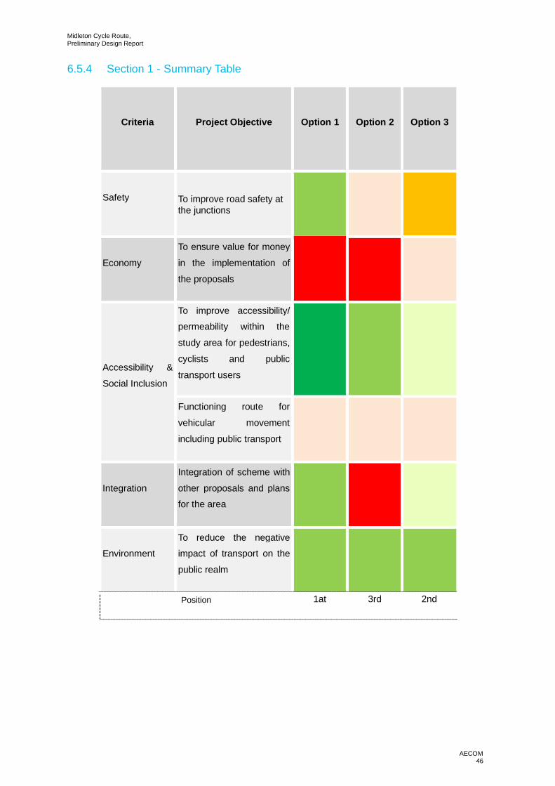
6.5.4 Section 1 - Summary Table
Criteria Project Objective Option 1 Option 2 Option 3
Safety To improve road safety atthe junctions
Economy
To ensure value for money
in the implementation of
the proposals
Accessibility &
Social Inclusion
To improve accessibility/permeability within the
study area for pedestrians,
cyclists and public
transport users
Functioning route for
vehicular movement
including public transport
Integration
Integration of scheme with
other proposals and plansfor the area
EnvironmentTo reduce the negativeimpact of transport on the
public realm
Position 1at 3rd 2nd
Midleton Cycle Route,Preliminary Design Report
AECOM47
6.6 Section 2 - Preferred OptionOption 1 has been identified as the preferred option following the assessment of each of the options
against the project objectives. Appendix A provides the preliminary design drawings for the preferred
option.
6.6.1 Preferred Option Summary
· Shared Use path along Riverside Way adjacent to Owenacurra River.
· Toucan crossing at the Riverside Way / Church Street junction with widened footpaths where
possible.
· Cycle Parking facilities to be provided on Riverside Way.
· Crossing location to be provided on New Cork Road.
· Footpath widened to shared use path around roundabout.
· Off-road greenway to be provided on western side of the Owenacurra River between Midleton retailPark and the Northern Relief Road.
· Underpass to be constructed at the crossing of the Cork to Midleton Railway line.
· Toucan Crossing to be provided on Northern Relief Road to connect route with Water Rock
Masterplan site.
· Cycle lanes on Northern Relief Road to be widened to allow for two directional cycling.
· Footpath widened on R626 to shared use path to connect to Midleton Rail Station and Midleton to
Youghal Greenway.
6.6.2 Land Acquisition
Land acquisition will be required along the preferred route. The anticipated locations of land acquisition
are highlighted on the prelim design drawings. All land acquisition will be subject to completion of a
detailed design
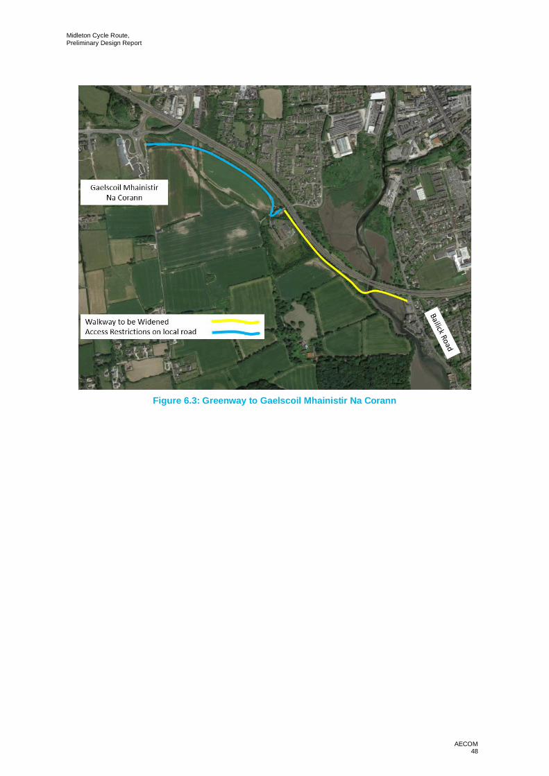
6.7 Additional OpportunitiesThe proposed scheme along the Bailick Road passes an existing off-road walk from the Bailick Road
to the entrance to the Ballyannan Woods with an access road going from the entrance to the woods to
Gaelscoil Mhainistir Na Corann.
As part of this project the existing off-road walk will be widened where necessary to upgrade the route
to an off-road Greenway. It is also proposed to limit the use of the access road to vehicles entering the
wastewater treatment plant to extend the greenway as far as Gaelscoil Mhainistir Na Corann. This will
provide higher quality of service to pedestrians and cyclists along the route
Midleton Cycle Route,Preliminary Design Report
AECOM48
Figure 6.3: Greenway to Gaelscoil Mhainistir Na Corann
Midleton Cycle Route,Preliminary Design Report
AECOM49
7. Conclusions
7.1 Preferred Scheme OverviewThe following provides a detailed description of the preferred route.
Section 1: R360 – 270m from Maple Woods Housing Development to Pedestrian/Cycle Link toThe Crescent Housing Development – Approx. Length 270m
The first section will consist of a 2m footway, 3m two-way cycle track, 1m separation strip and 7m
carriageway (existing). The footway and cycle track will be located on the west side of the carriagewayand the existing right turn lane into Maple Woods will remain. The 3m cycle track will replace the existing
hard shoulder. An Outer Gateway feature will be provided to reduced speeds on approach to an urban
area where the carriageway will be reduced to 6m. Landscaping will be provided to reduce the
carriageway.
Section 2: R630 - Pedestrian/Cycle Link to The Crescent Housing Development to PedestrianCrossing South of the L3621 (Bailick Road) – Approx. Length 180m
The next section involves the reallocation of carriageway cross section and utilisation of verge space
to accommodate the new cross section. The carriageway is to be reduced to 7m wide with a 3m two-
way cycle track, 1m separation strip and 2m footway on both sides of the carriageway. Continuous
crossings will be provided on the junctions with Church Road. The footways and cycle tracks connect
to a controlled pedestrian crossing to provide a safe crossing point.
Section 3: R630 - Pedestrian Crossing South of the L3621 (Bailick Road) to the LakeviewRoundabout on the N25 – Approx. Length 820m
A consistent solution is to be incorporated from the new pedestrian crossing south of the L3621 (Bailick
Road) to the proposed tie-in point south of the Lakeview Roundabout on the N25. The existing
impermeable surface corridor space will be reallocated to provide a 7m carriageway, 1.8m cycle tracks,
1m separation strip, footways (varying width) on either side of the carriageway. Proposed landscapingareas and formalised parking will be provided where the road space permits.
The junction with the L3621 (Bailick Road) will be altered to reduce corner radii and improve safety for
all road users. The junction with Dark Road will be signalised which will improve road safety for all road
users and in particular allow pedestrians and cyclists to cross the busy R630. The corner radii at all
other junctions will be reduced to improve road safety.
An Inner Gateway will be provided between Church Road and South Quay to further reduce vehicular
speeds on approach to the town centre. The carriageway will be reduced to 6m with red coloured
surfacing and landscaping on either side of the carriageway.
Section 4: L3621 (Bailick Road) – Junction with R630 to Charleston Warf Apartments – Approx.Length 310m
As previously discussed, the junction the R630 and the L3621 (Bailick Road) will be upgraded to
improve road safety. The L3621 (Bailick Road) will become one-way westbound to the northern
entrance of the Charlestown Warf apartment block, the width of the carriageway will be 3.5m. A 3m

Midleton Cycle Route,Preliminary Design Report
AECOM50
shared use path will be provided on the southern side of the carriageway. Due to existing constraints,
the shared use path will be reduced to 2.2m to 2.5m for 29m in front of the Charlestown Maltings
apartment block. An existing footway starting at ‘Oikoseen House’ will be widened to 2m.
Section 5: L3621 (Bailick Road) – Charleston Warf Apartments to Junction with Dark Road –Approx. Length 145m
A 3m shared use path will continue on the western side of the carriageway, the carriageway will return
to a 6m two-way system and the footway on the eastern side will be increased to 2m wide. Land take
will be required to accommodate the shared use path. The land will be acquired from a site that is zonedfor development. The junction between L3621 (Bailick Road) and Dark Road will be upgraded to
improve safety for all road users.
Section 6: Dark Road – Approx. Length 245m
The junctions at either end of Dark Road will be upgraded to improve road safety. The cross section of
Dark Road will change, a 2m footway will be provided on the northern side of the carriageway, the
carriageway will be formalised with kerbing and reduced to 6m, a 3m shared use path will be provided
on the southern side of the carriageway. The existing house entrances will remain, and an uncontrolled
pedestrian crossing will be provided on the western end of Dark Road. Landscaping will be provided to
the rear of the footway between it and the boundary walls.
Section 7: L3621 (Bailick Road) – Junction with Dark Road to 10m North of Historical Warehouse– Approx. Length 110m
A 3m shared us path will be provided on the western side of the carriageway; the carriageway will be
6m wide. The provision of the shared use path will improve the visibility at this location. Land acquisition
will be required and the existing boundary wall at the warehouse will be removed. A pinch point will exist
where the 3m shared use path reduces to 2.4m for 1m at the corner of the warehouse.
Section 8: L3621 (Bailick Road) Offline Section – Approx. Length 125m
A 3m shared use path will be provided on the western side of the carriageway; inside the existing stone
wall. The existing carriageway will remain. Gaps will be provided in the existing wall to allow for access
and egress.
Section 9: L3621 (Bailick Road) Offline Section to N25 Underpass – Approx. Length 270m
A 3m shared use path will be provided on the eastern side of the carriageway. The existing carriageway
will be reduced to 6m and realigned further to the west. The existing footway will be removed from thewall outside of the ‘Moorings’ Apartment Block with a new footway constructed within the apartment
grounds to connect to the new infrastructure to the north of the site.
Section 10: L3621 (Bailick Road) N25 Underbridge to Main Street via Broderick Street – Approx.Length 900m
A 3m shared use path will be provided on the eastern side of the carriageway from the N25 Underbridge
to the junction with Riverside Way. On Broderick Street a 3m two-way cycleway will be provided on the
Midleton Cycle Route,Preliminary Design Report
AECOM51
northern side of the carriageway. The existing footway will be widened to the east through a combination
of widening into the existing verge and minor land acquisition. The existing side roads into the residential
developments (Riverside Park, Riverside Estate and Father Murphy Place) will have their access pointsaltered to reduce the crossing distance. Continuous crossings will be provided at each junction. A new
bridge is required over the tributary to the Owenacurra River, the proposed bridge will run parallel to the
existing road bridge. A new signalised pedestrian crossing will be provided in advance of the junction
with Riverside Way.
Section 11: Riverside Way – Junction with Broderick Street to Junction with Church Lane –Approx. Length 300m
The southern footway of Kennedy Park will be widened into the area of verge adjacent in order to
provide a 4m shared use facility. At its junction with Riverside Way, a raised table crossing will be
provided to facilitate north / south crossing movements, which would then link proposed areas of shared
footways either side of the carriageway. The eastern footway will remain as is, however, a 3.5m shared
use path will be provided on the western side of the carriageway. The footway will be widened through
a combination of land acquisition, widening into the carriageway and widening into the verge to tie into
the existing junction at Church Lane. The majority of the widening will occur by maintaining the existingback of footway and widening into the carriageway. At the Riverside Way/Church Lane junction the
existing crossings will be upgraded to toucan facilities on all arms. A mid-block toucan crossing will be
provided to facilitate the east/west movement.
Section 12: Riverside Way –Junction with Church Lane to The Cork Road Gyratory – Approx.Length 282m
The western footway will be widened to 3.5m to provide a shared use facility. The widening will occur
through a combination of widening into the existing carriageway. Land acquisition will be required to
remove a pinch point in the carriageway on approach to the gyratory and widening into the existing
verge will also be required at this location. The path will connect to two Toucan Crossings at the Cork
Road Gyratory where the path will continue offline.
Section 13: Greenway – Cork Road Gyratory to Northern Relief Road (Water-Rock Masterplansite) – Approx. Length 1100m
The next section consists of an offline 4m wide shared use path that will extend from Cork Road
Gyratory to Northern Relief Road (Water-Rock Masterplan site). This will run parallel to the River
Owenacurra and underneath the Midleton Railway Line via an underpass which will consist of a
reinforced concrete 'cut-and-cover' box culvert. Cork County Council have engaged with Irish Rail to
agree the proposal at this location.
Section 14: Northern Relief Road (Water-Rock Masterplan site) to Midleton Railway Station andthe Youghal to Midleton Greenway – Approx. Length 806m
The Greenway section will connect to a controlled pedestrian crossing of the Northern Relief Road, it’s
from this point cyclists will continue into the Water-Rock Development. The next section of route would
follow existing cycle facilities provided adjacent to the carriageway of the Northern Relief Road, with

Midleton Cycle Route,Preliminary Design Report
AECOM52
potential to widen the existing one-way cycle paths to facilitate two-way cycling on either side of the
carriageway which will connect to Toucan Crossings on the R626/Northern Relief Road junction.
Cyclists will continue south on the R626 via a 3m shared use path on the eastern side of thecarriageway. The existing footway will be widened to 3m and the existing carriageway will be reduced.
The existing footpath running adjacent to the station car park will be widened in order to provide a 3m
minimum shared use facility and a link to the railway station.
Section 15: Greenway – Bailick Road to Gaelscoil Mhainistir Na Corann – Approx. Length 1600m
This section consists of an offline Greenway from Bailick Road to Gaelscoil Mhainistir Na Corann, the
existing path will be upgraded to provide improved pedestrian and cycling facilities including public
lighting.

Midleton Cycle Route,Preliminary Design Report
AECOM53
Appendix A - Drawings

Midleton Cycle Route,Preliminary Design Report
AECOM54
Appendix B – AA Screening
aecom.com

Midleton Cycle Route,Preliminary Design Report
AECOM55