mineral exploration, mining & geoscience kitikmeot...
TRANSCRIPT
NUNAVUT MINERAL EXPLORATION, MINING & GEOSCIENCE
KITIKMEOT REGION
http://cngo.ca/exploration-overview/2016/
OVERVIEW 2016
My Kaywa QR-Codehttp://cngo.ca/exploration-overview/2016/
http://kaywa.me/rpk4x
Download the Kaywa QR Code Reader (App Store &Android Market) and scan your code!
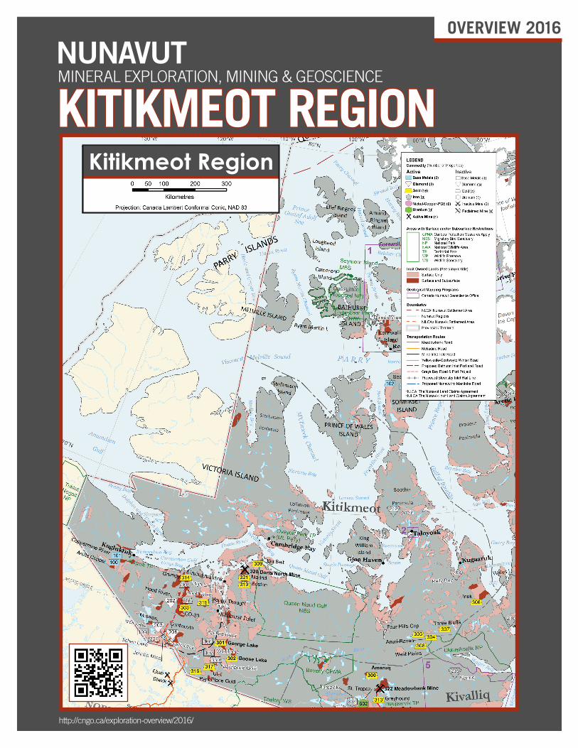
Kitikmeot Region

Please refer to the map on the cover for the location of active and inactive projects in the Kitikmeot region. Bold text significies a major project.
KitiKmeot Region geologyThe Kitikmeot region has some of the oldest rocks in Canada formed during the Precambrian Eon, when the Earth was forming 4.5 billion years ago. These granitic and volcanic metamorphic rocks that make up the northern part of the Canadian Shield, have been deformed at various times in the past by mountain building events. Deeply eroded, folded, and faulted rocks are exposed across the present landscape of the mainland and can host metallic deposits, such as gold, silver, nickel, or platinum. Clues as to where the metallic deposits occur can be found by prospecting with ground and airborne geophysical surveys, geochemical surveys or discovered by their association with quartz veins or rusty weathering of sulphide-rich rocks.
On Victoria and Prince of Wales Islands, north of the mainland, flat lying or gently tilted sedimentary rocks of the Paleozoic Arctic platform
were deposited over the ancient granitic and volcanic Shield rocks while they were submerged below an ocean basin. These sedimentary rock layers preserve numerous marine fossils. The bedrock in the region is often hidden beneath a cover of much younger clay, sand, and gravel deposited by glaciers. This material is formed by the grinding down of bedrock by the action of glaciers and was left behind as the ice disappeared. Fragments of harder minerals can be found in this material and can, in some cases, be traced to their place of origin.
Selected mining and exploRation HigHligHtSTMAC Resources Inc.’s Hope Bay project encompasses three separate deposits and mineralized trends – Doris, Madrid and Boston – located within the 80 km-long Hope Bay greenstone belt. Total Measured and Indicated Mineral Resource for the entire
numbeR pRoject opeRatoR StatuS
BASE METALS
100 Arctic Copper Arctic Copper Corp. Active
101 Coppermine River Kaizen Discovery Inc. Active
106-107 Hackett River – 106, Wishbone – 107 Glencore plc Inactive
108-109 Izok Corridor (High Lake – 108, Izok Lake – 109) MMG Limited Inactive
GOLD
301-302 Back River (Goose Lake – 301, George Lake – 302) Sabina Gold & Silver Corp. Active
303 CO-20 Transition Metals Corp. Active
304-308Committee Bay (Anuri-Raven – 304, Four Hills-Cop – 305, Inuk – 306, Three Bluffs – 307, West Plains – 308) Auryn Resources Inc. Active
309 Elu Belt TMAC Resources Inc. Active
314-317Grumpy – 314, Happy Thought – 315, Park Place Gold – 316, Uist – 317 Silver Range Resources Inc. Active
319-321 Hope Bay (Boston – 319, Doris – 320, Madrid – 321) TMAC Resources Inc. Active
326 Hood River WPC Resources Inc Inactive
327 Itchen Lake Transition Metals Corp. Inactive
329 Lupin Mine WPC Resources Inc Inactive
330 Wishbone Gold Sabina Gold & Silver Corp. Inactive
DIAMONDS
201-203 Hood River Crystal Exploration Inc. Active
206 Jericho Mine INAC (abandoned by Shear Diamonds Ltd.) Inactive
209 Pelly Bay Churchill Diamond Corporation Inactive
212 Stein Arctic Star Exploration Corp Inactive
KitiKmeot Region
belt is in excess of 4.5 million ounces of gold with an additional 1.4 million ounces of gold in the Inferred Mineral Resource. Through aggressive exploration and development, the company is bringing its Doris North deposit to production scheduled to commence in the first quarter of 2017. In the buildup to production TMAC successfully transported and off-loaded the new processing plant and assembled it in the newly constructed process plant building. In anticipation of increased air traffic to and from the mine site, upgrades to Hope Bay airstrip were completed with the runway widened to 40 meters and lengthened to 1500 meters. This expansion enables the airstrip to accommodate large jets.
Exploration work was limited this year due to the focus on bringing the processing and support facilities into operation. Work completed until July 2016 involved the drilling of 67 drill holes totaling 19,402 metres at Doris with an additional 4,680 meters drilled in 17 holes at Madrid’s Naartok zone. Drilling at Doris was primarily focused on advancing the understanding of gold mineralization in the Below The Dyke Zone.
TMAC progressed through the regulatory requirements and received an amended Doris North project certificate, marking the completion of the Nunavut Impact Review Board environmental assessment process. An amended Type A Water Licence for Doris was issued by the Nunavut Water Board in November 2016 and signed by the Minister of Indigenous and Northern Affairs in December 2016. The amended licence will allow the Doris North mine life to be extended to 6 years.
In addition to the Hope Bay property, TMAC holds approximately 68,000 hectares of mineral claims within its Elu Belt project. The Elu greenstone belt is located approximately 30 km northeast of the Hope Bay belt, is of similar age, and has potential to host precious and base metal deposits. During the 2016 exploration season TMAC completed the remaining portion of the magnetic-electromagnetic geophysical survey which was halted in 2015 due to the early onset of winter.
Sabina Gold and Silver Corporation owns the advanced Back River gold project, which is located on a 80 km long block of claims, approximately 75 km southwest of Bathurst Inlet. Several new gold deposits have been discovered by the company at Back River since purchasing the project in 2009. The Back River project currently contains measured and indicated resources of 5.33 million ounces of gold with an additional 1.85 million ounces of gold in the inferred resource category. Current proven and probable mineral reserves are estimated at 2.50 million ounces of gold grading at 6.3 grams per tonne gold. In 2016 Sabina Gold & Silver Corp. completed a modest spring exploration drill program which focused on testing three mineralized zones. The program consisted of 16 short diamond drill holes and produced a new discovery in the vicinity of the Convergence prospect. In June 2016, the Nunavut Impact Review Board issued its determination to the Minister of Indigenous and Northern Affairs recommending that Sabina’s Back River project not proceed to the licensing and permitting regulatory phase at this time. The Minister’s response is pending.
Auryn Resources embarked on an extensive field program in the summer of 2016. The exploration program consisted of boulder train mapping, till sampling, drone imagery survey covering over
3,500 square kilometers, and both rotary air blast and diamond drilling. A till sampling program was conducted across the Committee Bay project and consisted of 6450 till samples covering 85% of the Committee Bay belt and resulted in identification of 17 new, multi-kilometer, high priority anomalies. Boulder train mapping targeted eight previously identified discreet trends and identified high grade gold mineralization at Anuri and Ridge. In addition to till and boulder sampling a 10,000 m rotary air blast and 3,750 m diamond drill programs were completed. The rotary air blast drilling method is an economical way to sample bedrock below the glacial till cover and was used to test two target areas identified during the 2015 exploration program.
Auryn staked an additional 160,000 hectares of new claims along the belt, and increased its land tenure to over 380,000 hectares. Plans for the 2017 exploration program include 25,000 metres of drilling to test new significant targets delineated during the 2016 program and till sampling program covering the remaining 15% of the belt.
Silver Range Resources Inc. is a new entry to Nunavut mineral exploration in 2016. The company assembled a portfolio of four Kitikmeot gold prospects located in the vicinity of the proposed Grays Bay road: Grumpy, Happy Thought, Park Place Gold and Uist. Exploration on these prospects was limited to the initial confirmatory sampling conducted during the staking of these claims.
Crystal Exploration Inc. is a Canadian junior company exploring for diamonds in the Kitikmeot Region. The company currently holds 1,150 km2 in eight prospecting permits covering the Hood, Muskox and Contwoyto project areas. Crystal acquired these properties in a deal finalized in November 2015.
The 2016 program consisted of a high resolution magnetic survey, till sampling, prospecting and mapping. A total of 146 till samples and two rock samples were collected and submitted for analysis. The magnetic survey was done as a follow up to ground truthing of 72 prospective targets prioritizing accordingly. These surveys resulted in delineating five high priority, “bullseye” drill targets, ranging from 123 to 225 meters in size.
Following the exploration program, the company announced the addition of a 150 hectare mineral claim adjacent to the Muskox Project containing a possible sixth high priority target. A NI 43-101 Technical Report and the analytical results from 2016 program are expected to be released in Q4 of 2016.
pRogRamS and StudieScaRving Stone depoSit evaluation pRogRam
The Nunavut Carving Stone Deposit Evaluation Program is a collaborative project between the Government of Nunavut, Department of Economic Development and Transportation (EDT) and the Canada-Nunavut Geoscience Office (CNGO) funded by the Canadian Northern Economic Development Agency and EDT. The objectives of this EDT-led territory-wide project are to locate and evaluate known and new carving stone deposits and assess their potential to provide nearby communities with a long term supply of quality carving stone for artisanal purposes. Geologists from the GN and CNGO have worked closely with carvers and other community members during this program to evaluate carving stone resource sites.
KitiKmeot Region

These sites are located near communities in all three regions. In the Kitikmeot region, there are 11 quarries and 15 additional undeveloped deposits with sufficient deposits of carving stone to provide artisans with several decades’ supply of carving stone. A carving stone map of Nunavut has been developed and is planned for distribution in 2017.
nunavut pRoSpectoRS pRogRam and pRoSpectoR tRaining
The Government of Nunavut’s Economic Development and Transportation department held a prospector training course in Taloyoak in 2016. These courses introduce participants to basic prospecting skills and provide an introduction to geological concepts. To date, more than 1,160 Nunavummiut have successfully completed the course. Graduates of the course may qualify for financial and technical assistance through the Nunavut Prospectors’ Program to pursue their own projects, and some find opportunities to work as field assistants on mineral exploration projects. Courses are planned to be held in Cambridge Bay and Kugaaruk in 2017.
gloSSaRy of teRminologyDeposit – a natural accumulation of a metal, gemstone or other valuable mineral substance, which may be economically viable but whose characteristics require more detailed study to be classified as a resource.
Drilling – the operation of extracting a vertical sample of bedrock or other surface material such as glacial till or clay in order to examine the occurrence of rock types and understand the geological structure.
Exploration – the process of searching for mineral deposits.
Geochemical survey – the chemical analysis in a laboratory of soil, rock, or water from a defined area to identify abnormal concentrations of chemical elements that indicate the presence of metals, petroleum, or gemstones. Also known as geochemical exploration.
Geophysical survey – the collection of information associated with bedrock using sensors that record electric, magnetic, seismic, or thermal data. The survey can be conducted from the air or the ground and is used by mineral exploration companies to detect physical properties of rocks such as magnetism, gravity or conductivity.
Grab sample – a rock sample, collected by hand, in order to analyze whether valuable minerals or metals are present.
Greenstone belt – a linear zone or “belt” of metamorphosed volcanic rocks that often host deposits of gold and other valuable metals. The characteristic colour comes from several different green minerals that make up the volcanic rocks. Greenstone belts can be tens to hundreds of kilometres in length and are found in multiple places across Nunavut.
Prospecting – the search for outcrops or surface exposures of mineral deposits with economic potential.
Reserve – a published estimate of the amount of naturally occurring metal, gemstone, or other mineral substance in a mineral deposit that can be economically extracted at the time the estimate is published. Classifying a reserve within a deposit indicates that there is strong confidence in the quantity and quality of ore in that deposit. Specific legal criteria exist to classify a deposit as a reserve.
Resource – a published estimate of the amount of naturally occurring metal, gemstone, or other mineral substance in a mineral deposit that could allow for economic extraction of the material in the future. Classifying a resource within a deposit indicates there is moderate confidence in the quantity and quality of ore in that deposit. Specific legal criteria exist to classify a deposit as a resource.
cHecK out tHe nunavut exploRation oveRview on-line:
www.NunavutGeoscience.catHe moSt autHoRitative Stop foR nunavut geoScience infoRmation.
canada-nunavut geoScience office
) 867 975 4412 7 867 979 0708
goveRnment of nunavut
Department of Economic Development and Transportation
Minerals and Petroleum Resources Division
) 867 975 7800 7 867 975 7870
[email protected] www.edt.gov.nu.ca
goveRnment of canada
Indigenous and Northern Affairs Canada
Resource Management Directorate
) 867 975 4500 7 867 975 4276
AANDC.MineralsNU-MinerauxNU. [email protected] AANDC.ArchivesNU.AADNC@aandc- aadnc.gc.cawww.aandc-aadnc.gc.ca/nu
nunavut tunngaviK incoRpoRated
Lands, Minerals, Oil and Gas
) 867 983 5600 7 867 983 5624
KitiKmeot Region