mineral resource estimate for the sinclair … · 2017-03-22 · mineral resource estimate for the...
TRANSCRIPT
1
MINERAL RESOURCE ESTIMATE FOR THE SINCLAIR CAESIUM PROJECT
Australia’s First Caesium Resource: 10,500t grading 17.1% Cs2O
• Metallurgy Underway - Preliminary Indications for Caesium Formate Production
• Mine Planning Underway – Mining Lease Applied For and Design Work Commences
• January Drill Results Include 3m at 11.5% Cs2O from 49m in PDRC094
Perth, Western Australia: 22 March, 2017: Pioneer Resources Limited (the "Company" or “Pioneer”)
(ASX: PIO) is pleased to announce a Mineral Resource Estimate for the Sinclair Caesium Zone, which is
within the Company’s 100%-owned Pioneer Dome Lithium-Caesium-Tantalum (“LCT”) Project.
Caesium, within the mineral pollucite, is currently mined in small quantities at the Tanco Mine in
Manitoba, Canada, and sporadically at the Bikita Mine in Zimbabwe. Supply is considered very
constrained.
The Pioneer Dome LCT Project is well serviced by existing mining-related infrastructure with the
Goldfields to Esperance Highway and Railway traversing the Project. It is situated 30km north of
Norseman and 150km south of the regional centre of Kalgoorlie (Figure 1).
MINERAL RESOURCE ESTIMATE
The Mineral Resource Estimate is 10,500t of the caesium ore ‘pollucite’ with a grade of 17.1% Cs2O,
as summarised by category in Table 1 below:
Table 1. Mineral Resource Summary by Category: Sinclair Caesium Deposit
Classification Tonnes (t) Cs2O (%)
Measured 10,500 17.1
Total 10,500 17.1
Note: Appropriate rounding applied
DRILLING INTERSECTS ADDITIONAL CAESIUM AND PROVIDES ADDITIONAL TARGETS
During January 2017, the Company completed 22 reverse circulation (“RC”) drill holes (PDRC088-
PDRC109) for 1,446 metres, drilled along strike both north and south of the Sinclair Caesium Zone to
test for evidence of further caesium mineralisation.
The high-value caesium mineral pollucite was intersected at an extension to the Sinclair Zone,
bringing the mineralised strike length to 70m (Figure 2 and Appendix 1). In addition, geochemical
vectors for pollucite were indicated in the drill information, making the Sinclair Caesium Zone one of
a number of caesium and lithium targets to be further investigated going forward.
Significant high grade caesium drill intersections from the January 2017 drilling included:
PDRC090: 1m at 12.3% Cs2O from 48m
PDRC093: 2m at 10.4% Cs2O from 49m
PDRC094: 3m at 11.5% Cs2O from 49m

2
The results listed above are in addition to earlier reported caesium intersections including:
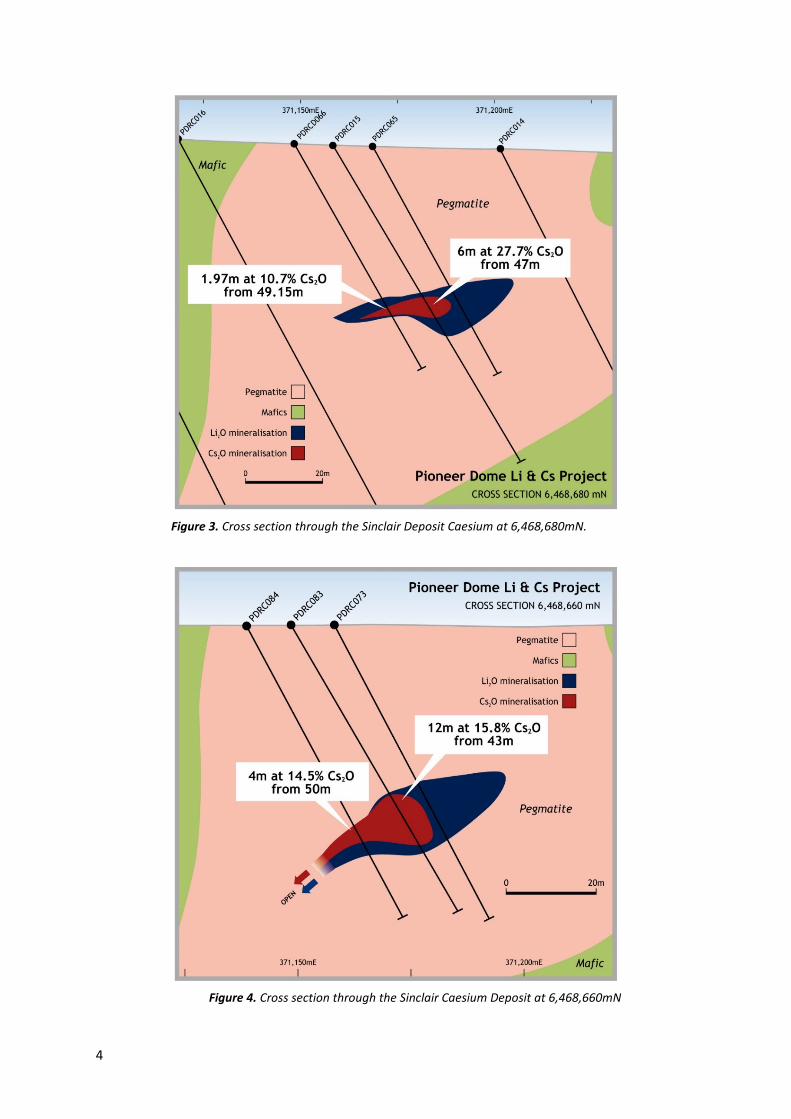
PDRC015: 6m at 27.7% Cs2O from 47m
PDRC074: 7m at 17.12% Cs2O from 49m
PDRCD068: 3.85m at 27.78% Cs2O from 44.35m
PDRCD071: 6.35m at 18.60% Cs2O from 41.4m
PDRC083: 12m at 15.77% Cs2O from 43m
Pioneer’s Managing Director, David Crook, said “The Mineral Resource Estimate is a significant step
toward the Company realising the value of the Sinclair Caesium Zone, which was discovered in
September 2016.
“Preliminary metallurgy is looking very positive, with a simple process identified that can produce the
very high value, high density caesium formate brine for use in the Oil and Gas industry.
METALLURGY
Strategic Metallurgy Pty Ltd has been engaged to conduct a series of tests to determine an optimal
processing route, along with capital and operating cost estimates for the selected processing route.
Material for the initial metallurgical testing is a 25kg composite sample from the RC and Diamond
Drilling completed in 2016.
The metallurgical tests on the pollucite sample have readily resulted in the production of a very high
density, clear fluid that is expected to be confirmed through chemical analysis as caesium formate
brine.
The second round, testing the leaching characteristics of varying size fractions, has commenced.
The Company is also advancing negotiations with parties interested in securing pollucite or caesium
product offtake.
BASIS FOR THE MINERAL RESOURCE ESTIMATE
The Mineral Resource estimate presumes a single body of pollucite (hydrated caesium alumina-
silicate) approximately 40m below surface within a highly fractionated LCT pegmatite intrusive.
Geologically, the pollucite occurs within the most-highly differentiated ‘core’ of the PEG08 pegmatite.
The deposit has been drilled on a 10 x 10m grid using Industry-standard RC and Diamond drilling
techniques, allowing the Mineral Resource Estimate to be classified as a Measured Resource. There
are over 70 bulk density measurements within the deposit, all holes have been downhole surveyed
with a north seeking gyroscope probe and the collar coordinates have been surveyed with a RTK DGPS
by a licenced surveyor.
Reverse circulation drill holes were sampled on a 1m basis downhole, and Diamond sampling was
conducted on a geological unit basis, with a minimum downhole sample length of 0.3m and a
maximum downhole length of 1m. All samples were submitted to Intertek Genalysis for a 48-element
geochemical analysis suite that utilised a four acid digestion and an ICP-MS determination.
All ore range chemical assay results were re-assayed using fused disk preparation with a mixed acid
digestion followed by an ICP-MS determination. Standards and duplicates were inserted to confirm
the accuracy and quality of the assay results. All QAQC samples returned results within acceptable
limits.

3
Figure 1. Location diagram for
the Pioneer Dome Lithium
Caesium project
Figure 2. Drill hole Plan and interpreted Geology of the Sinclair Caesium
Deposit project
Photograph 1. From diamond core hole PDRCD071, Pioneer’s geologists have logged the interval between
41.40m and 47.70m (highlighted in green) as being predominantly pollucite.
4
Figure 3. Cross section through the Sinclair Deposit Caesium at 6,468,680mN.
Figure 4. Cross section through the Sinclair Caesium Deposit at 6,468,660mN

5
Figure 5. Oblique view of the overall Sinclair Deposit wireframe looking northwest. The Pollucite zone is 70m
long and 15m wide.
Figure 6. Grade-tonnage curves from the Resource Estimation of the Sinclair Deposit.

6
OUTLOOK
The Company is preparing to collect a bulk sample of pollucite for larger scale comminution and
metallurgical test work by way of an adit. Preparation includes a mine design, environmental studies
and a safety management plan.
In addition, drilling and soil geochemistry has identified other priority exploration targets for caesium
and lithium with the next round of drilling planned to resume in the June quarter of 2017. Specific
holes will also be drilling for geotechnical studies.
About Pioneer Resources Limited
The Company’s strategy is to actively explore for key, global demand-driven commodities in highly
prospective geological domains, in areas with low geopolitical risk and with established infrastructure.
The Company’s portfolio includes high quality lithium and caesium assets in Canada and WA, plus
strategically located gold and nickel projects in mining regions of Western Australia.
The Company is currently awaiting assay results from a drilling programme recently completed at the
Mavis Lake spodumene project in Ontario.
Pioneer’s priority is to advance the Sinclair Caesium Zone towards commercialisation, and to advance
other lithium (in spodumene) and caesium (in pollucite) targets, including those at PEG004, PEG008
and PEG009, within the Pioneer Dome.
The Company recently announced a joint venture for its Acra Gold Project by which Northern Star
Resources Limited may earn a 75% interest.
The Company also owns a portfolio of nickel, gold and base metal prospects. A drilling programme is
forecast at the Blair Nickel Mine before May 2017, and an appraisal of the cobalt potential of the
Golden Ridge Project is in progress.
Managing Director
Pioneer Resources Limited
For further information please contact:
David Crook James Moses
Managing Director Media and Investor Relations
Pioneer Resources Limited Mandate Corporate
T: +61 8 9322 6974 M: +61 420 991 574

7
References
Company announcements to ASX 19 May 2016, 27 July 2016, 28 August 2016, 1 September 2016,
4 October 2016, 17 October 2016, 14 November 2016, 13 December 2016 and Quarterly Activity
Reports.
Competent Person’ Statement
The information in this report that relates to Exploration Results is based on information supplied to and compiled
by Mr David Crook and Mr Paul Dunbar. Mr Crook is a full time employee of Pioneer Resources Limited and Mr
Dunbar employed by Dunbar Resource Management who consultants to Pioneer Resources. Both Mr Crook and
Mr Dunbar are members of The Australasian Institute of Mining and Metallurgy (member 105893 and 204611)
and members of the Australian Institute of Geoscientists. Mr Crook and Mr Dunbar have sufficient experience of
relevance to the styles of mineralisation and types of deposit under consideration, and to the activities
undertaken to qualify as Competent Persons as defined in the 2012 Edition of the Joint Ore Reserves Committee
(JORC) Australasian Code for Reporting of Exploration Results, Mineral Resources and Ore Reserves
The information in this report that relates to Mineral Resources is based on and fairly represents information
compiled by Mr Paul Dunbar and Mr Lauritz Barnes, both of whom are consultants to Pioneer Resources
Limited. Mr Barnes and Mr Dunbar are members of the Australasian Institute of Mining and Metallurgy and
have sufficient experience of relevance to the styles of mineralisation and types of deposits under
consideration, and to the activities undertaken to qualify as Competent Persons as defined in the 2012 Edition
of the Joint Ore Reserves Committee (JORC) Australasian Code for Reporting of Exploration Results, Mineral
Resources and Ore Reserves. Specifically, Mr Dunbar is the Competent Person for the database, geological
model and interpretation plus completed the site inspections. Mr Barnes is the Competent Person for the
resource estimation. Mr Dunbar and Mr Barnes consent to the inclusion in this report of the matters
based on their information in the form and context in which they appear.
Caution Regarding Forward Looking Information
This document may contain forward looking statements concerning the projects owned by the
Company. Statements concerning mining reserves and resources may also be deemed to be forward
looking statements in that they involve estimates based on specific assumptions.
Forward-looking statements are not statements of historical fact and actual events and results may
differ materially from those described in the forward looking statements as a result of a variety of risks,
uncertainties and other factors. Forward-looking statements are inherently subject to business,
economic, competitive, political and social uncertainties and contingencies. Many factors could cause
the Company’s actual results to differ materially from those expressed or implied in any forward-
looking information provided by the Company, or on behalf of, the Company. Such factors include,
among other things, risks relating to additional funding requirements, metal prices, exploration,
development and operating risks, competition, production risks, regulatory restrictions, including
environmental regulation and liability and potential title disputes.
Forward looking statements in this document are based on the Company’s beliefs, opinions and
estimates of the Company as of the dates the forward looking statements are made, and no obligation
is assumed to update forward looking statements if these beliefs, opinions and estimates should
change or to reflect other future developments.
There can be no assurance that the Company’s plans for development of its mineral properties will
proceed as currently expected. There can also be no assurance that the Company will be able to confirm
the presence of additional mineral deposits, that any mineralisation will prove to be economic or that
a mine will successfully be developed on any of the Company’s mineral properties. Circumstances or
management’s estimates or opinions could change. The reader is cautioned not to place undue reliance
on forward-looking statements.

8
MARCH 2017 SINCLAIR RESOURCE ESTIMATE AND REPORTING CRITERIA
As per ASX Listing Rule 5.8 and the 2012 JORC reporting guidelines, a summary of the material
information used to estimate the Mineral Resource is detailed below (for more detail please refer to
JORC 2012 - Table 1).
Location and Description
The Sinclair Caesium Deposit, owned 100% by Pioneer Resources Limited, is located approximately
40km north of Norseman in the Eastern Goldfields Province of Western Australia. The Pioneer Dome
project is well serviced by existing infrastructure including a sealed road, water pipeline, rail and a gas
pipeline all are related to the modern mining history within the Pioneer tenement package and the
proximity to other current and historic operations and the nearby regional centre of Kalgoorlie.
Geology and geological interpretation
The Pioneer Dome Project area occurs within the southern part of the Norseman-Wiluna greenstone
belt of the Yilgarn craton. The dominant geological features are the late Archean Pioneer Dome and
the older mafic and ultramafic units of the greenstone belt. Late stage pegmatite intrusive sills and
dykes intrude the older stratigraphy including a granite gneiss, located to the west of the Sinclair
Deposit.
Locally, the underlying geology comprises a series of N striking, westerly dipping belts of Archaean
mafic, ultramafic and sedimentary rocks. The entire sequence is intruded by a series of pegmatite
dikes and sills associated with the later stage Pioneer Dome granite intrusive. These pegmatite dykes
form a swarm of intrusive bodies along a strike length of approximately 15km along the eastern edge
of the granite dome. The area has been extensively explored since the late 1960’s for nickel sulphide
mineralisation associated with the extensive ultramafic volvanic units in the area. Historical
exploration consisted of geological mapping, trenching, geophysical surveys and minor drilling. No
historical drilling or exploration was conducted targeting lithium, caesium or tantalum nor the
abundant pegmatite bodies.
The Sinclair Caesium deposit occurs within a large differentiated pegmatite within the large pegmatite
swarm adjacent to the Pioneer Dome. Several of these pegmatite intrusive bodies, including the
PEG08 intrusive which hosts the Sinclair Caesium deposit, have a geochemical signature associated
with the Lithium Caesium Tantalum (LCT) subclass of pegmatites (London 2008). The Peg 08 pegmatite
and Sinclair deposit are geologically similar to the large Tanco Mine at Bernic Lake, Manitoba.
The caesium mineral pollucite is the primary mineral of interest within the Sinclair Caesium deposit.
The Pollucite occurs as a unique monomineralic (or almost monomineralic) zone within the larger
lepidolite zone within the core of the pegmatite. A common quartz and or lithium silicate zone occurs
either within or adjacent to the pollucite zone. The pollucite zone is spatially located within the core
of the larger PEG 08 pegmatite body at a vertical depth of approximately 40m below surface.
Drilling techniques and hole spacing
The Resource Estimate is based on a total of seven Reverse Circulation (RC) drill holes have been
completed from surface and five Diamond holes that have Pre-collars drilled, by RC, to an approximate
depth of 35m. In addition to these twelve holes that define the deposit an additional approximately
12 holes have been drilled to the east and along strike and limit the extent of the deposit to the east
and north, the deposit is open to the west and to the south. RC drilling was using a nominal 5 ¾ inch
drill bit with the diamond drilling consisting of NQ sized core. Core was oriented relative to the bottom
of the hole with meter marks determined from the drillers blocks and core loss determined from the
distance drilled against the length of core collected. The sample recovery was always greater than
95%, therefore no sample bias was derived from the sample recovery. Sample Recovery from the RC

9
drilling was determined from the relative size of the bulk residue material collected. The RC sample
recovery was consistent irrespective of the geological units being drilled.
Drilling commenced in the Peg 08 target zone in September 2016 with an initial very wide spaced
series of RC drill traverses. Drill hole PDRC015 intersected the core of the pegmatite and the pollucite
mineralisation returning a drill intersection of 6m at 27.7% Cs2O from 47m downhole. Additional
detailed RC and Diamond drilling was undertaken in November 2016 with additional extensional RC
drilling completed in January 2017. The drilling has been conducted on a 10m x 10m drill pattern
around the initial drill intersection with extensional drilling occurring on a slightly wider drill spacing.
All holes within the Resource area have been geophysically logged with several downhole logging tools
including gamma, active source density, optical tele viewer, magnetic susceptibility, orientation tools
and point resistivity. The downhole logging data assisted in the overall geological model and provided
confidence in the geological continuity of the pollucite mineralisation.
Sampling and sub-sampling techniques
Sampling information used in the resource estimation was derived from diamond core drilling and RC
drilling. Samples were collected at 1m intervals for the RC drilling with the diamond core sampling
being much more selective. For the core samples a minimum sample width was 30cm with a maximum
of 1m. The RC samples were an approximately 3kg sample collected from a cone splitter attached to
the drill cyclone. Duplicate samples were collected via a spear sample of the residue material which
was initially collected in buckets with later RC drilling programs collecting the bulk residue in plastic
bags. The Diamond core was sampled as half core cut by a diamond saw.
within geologically consistent mineralised zones. Sample sizes were determined to avoid sampling
across geological/mineralisation boundaries.
Sample Analysis Method
Sample preparation involved crushing and pulverising each entire sample. A sub-sample was analysed
for a forty-eight element geochemical suite including lithium, caesium, tantalum and associated
elements using a four acid digestion and an ICP-MS analytical technique (4A/MS). The upper range
for Caesium by the four-acid digestion is 2000ppm Cs. All over range samples were re assayed using
a fused disk (sodium peroxide), multi-acid digestion with concentrations determined by ICP-MS.
Bulk Density
The bulk density (BD) determination was carried out using the Gravimetric or water immersion
method, whereby half core samples were weighed dry and again while immersed in water. A
calculation is used to determine the bulk density of the drill core. Additional samples were tested by
a gas pycnometer which directly measures the density of the sample.
A total of 30 samples were used to determine the Bulk density by water immersion with an additional
44 samples had a density determined by a gas pycnometer determination by Intertek Genalysis.
Analysis of the density data has resulted in a density of 2.83 being used in converting the volume of
the mineralisation to a Resource Tonnage.
A review of the Bulk Density against the caesium grades has been completed with a weakly positive
correlation between grade and density however estimation of the density for different grade zones of
the deposit does not make a material difference to the overall Resource tonnage or grades.
Cut-off grades
In additional to the detailed geological logging, internal pegmatite zonation boundaries typically
coincide with anomalous or depleted Cs, Li and Ta which assisted in confirming geological continuity

10
of the mineralised zone. Changes in rock density also assisted in refining the positions of key
contacts. All pegmatite zonation (and grade) contact models were built in Leapfrog™ Geo software
and exported for use as domain boundaries for the block model.
Estimation Methodology
Grade estimation used both Inverse Distance Squared and Ordinary Kriging (for comparison) for Cs
(%) using GEOVIA Surpac™ software into the domain. The estimate was resolved into 2m (E) x 2m
(N) x 1m (RL) parent cells that had been sub-celled at the domain boundaries for accurate domain
volume representation. Estimation parameters were based on the variogram models, data
geometry and kriging estimation statistics. Potential top-cuts were analysed by completing an
outlier analysis using a combination of methods including grade histograms, log probability plots and
other statistical tools. Based on this statistical analysis of the data population, top-cuts were not
required for Cs %. Cs2O (%) is included in the block model as a direct calculation from Cs (%) using
the equation Cs2O (%) = Cs (%) x 1.0602. Tonnes have been reported on a dry basis.
Classification Criteria
The Sinclair Cs zone resource has been classified based on confidence in the detailed geological
understanding and defined continuity of the mineralised zone (drill spacing 10m x 10m) and the
available bulk density data. All factors considered, the resource estimate has been classified as a
Measured Resources.
Previous Mining and Metallurgical Methods and Parameters
There has been no previous mining within the PEG 08 pegmatite nor the Sinclair Deposit. Metallurgical
testing of the caesium and pollucite mineralisation is underway with the objective to confirm the high
density caesium formate brine is able to be produced from the pollucite that is the basis of the
Resource and also to provide a Scoping Study operating cost estimate for the production of the
caesium formate. While this metallurgical testing is ongoing Pioneer can confirm that a high density
brine (SG of 2.1g/cc) has been produced from the ground Pollucite. Additional testing is underway to
determine the density and chemical composition of the dense brine.
APPENDIX 1
Table 1: Summary of drill intersections used in the Resource Estimate
`
Hole
Type
MGA
Easting
MGA
Northing RL Dip
MGA
Azimuth
Hole
Depth
Depth
From
Interval
Length
Cs2O
(%)
PDRC015 RC 371,159.34 6,468,681.10 331.29 -60 90 108.0 46.0 8.0 22.6
PDRC074 RC 371,158.32 6,468,701.46 332.50 -60 90 73.0 49.0 7.0 16.2
PDRC083 RC 371,149.50 6,468,660.93 330.53 -60 90 73.0 43.0 13.0 14.8
PDRC084 RC 371,139.49 6,468,660.97 330.78 -60 90 73.0 50.0 4.0 14.5
PDRC090 RC 371,158.47 6,468,710.05 332.98 -60 90 66.0 48.0 1.0 12.3
PDRC093 RC 371,148.82 6,468,650.95 330.14 -60 90 72.0 48.0 2.0 10.4
PDRC094 RC 371,139.61 6,468,650.87 330.09 -60 90 78.0 49.0 3.0 11.5
PDRCD066 RCD 371,148.97 6,468,681.13 331.66 -60 92 66.6 49.2 2.0 11.4
PDRCD068 RCD 371,158.83 6,468,690.83 332.03 -60 90 66.3 44.0 4.2 25.7
PDRCD069 RCD 371,149.24 6,468,690.79 332.19 -60 90 69.6 51.3 1.7 19.1
PDRCD071 RCD 371,159.40 6,468,671.00 330.88 -60 90 66.6 41.4 2.0 28.2
PDRCD071 RCD 371,159.40 6,468,671.00 330.88 -60 90 66.6 45.0 2.8 22.2
PDRCD072 RCD 371,148.68 6,468,670.91 331.14 -60 92 75.3 51.0 1.2 2.2

11
APPENDIX 2
Table 2: Collar Coordinates for RC drilling completed in January 2017
Hole Id Hole
Type Grid ID Easting Northing RL
RC
Meters
Total
Depth
PDRC089 RC MGA94_51 371,167.2 6,468,710.0 332.41 66 66
PDRC090 RC MGA94_51 371,158.5 6,468,710.0 332.98 66 66
PDRC091 RC MGA94_51 371,148.3 6,468,710.0 333.05 78 78
PDRC092 RC MGA94_51 371,159.9 6,468,651.0 329.78 60 60
PDRC093 RC MGA94_51 371,148.8 6,468,650.9 330.14 72 72
PDRC094 RC MGA94_51 371,139.6 6,468,650.9 330.09 78 78
PDRC095 RC MGA94_51 371,149.5 6,468,641.2 330.01 66 66
PDRC096 RC MGA94_51 371,139.4 6,468,641.1 330.37 75 75
PDRC097 RC MGA94_51 371,149.6 6,468,494.4 338.80 36 36
PDRC098 RC MGA94_51 371,138.6 6,468,494.5 339.76 42 42
PDRC099 RC MGA94_51 371,128.6 6,468,494.5 339.46 48 48
PDRC100 RC MGA94_51 371,118.6 6,468,494.2 338.64 48 48
PDRC101 RC MGA94_51 371,108.4 6,468,493.9 338.02 54 54
PDRC102 RC MGA94_51 371,103.6 6,468,494.0 337.80 72 72
PDRC103 RC MGA94_51 371,148.0 6,468,460.6 339.45 18 18
PDRC104 RC MGA94_51 371,127.6 6,468,460.5 340.49 36 36
PDRC105 RC MGA94_51 371,117.2 6,468,460.7 339.82 54 54
PDRC106 RC MGA94_51 371,097.3 6,468,460.9 339.57 72 72
PDRC107 RC MGA94_51 371,087.6 6,468,493.2 338.80 87 87
PDRC108 RC MGA94_51 371,056.6 6,468,608.2 334.54 108 108
PDRC109 RC MGA94_51 371,129.4 6,468,650.7 330.71 72 72
PDRC110 RC MGA94_51 371,091.5 6,468,727.7 333.90 138 138 Notes:
• Hole locations were measured by a licenced surveyor in MGA 94 zone 51 using a DGPS which is considered fit for purpose.
• The azimuth is in degrees magnetic as derived from a hand held compass.
12
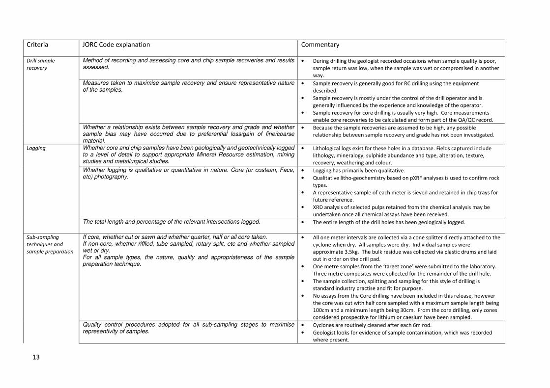
JORC (2012) Code – Table 1
Section 1 - Sampling Techniques and Data
(Criteria in this section apply to all succeeding sections.)
Pioneer Dome Project, Sinclair Caesium Prospect.
Criteria JORC Code explanation Commentary
Sampling
techniques
Nature and quality of sampling (eg cut Faces, random chips, or specific specialised industry standard measurement tools appropriate to the minerals under investigation, such as down-hole gamma sondes, or handheld XRF instruments, etc). These examples should not be taken as limiting the broad meaning of sampling.
• Reverse circulation (RC) and
• HQ Core samples from holes drilled from surface.
Include reference to measures taken to ensure sample representivity and the appropriate calibration of any measurement tools or systems used.
• Industry-standard reverse circulation drilling, using a face-sampling hammer
with a booster and auxiliary compressors used to ensure dry samples.
• Duplicate samples and Certified Reference Standards were inserted at regular
intervals to provide assay quality checks. The standards and duplicates
reported within acceptable limits.
• Industry-standard HQ2 diamond core drilling using a diamond-set cutting bit.
• Certified Reference Standards were inserted at regular intervals to provide
assay quality checks. The standards reported within acceptable limits.
• Samples are considered ‘fit for purpose’, being to detect anomalous metal
element occurrences.
Aspects of the determination of mineralisation that are Material to the Public Report. In cases where ‘industry standard’ work has been done this would be relatively simple (eg ‘reverse circulation drilling was used to obtain 1 m samples from which 3 kg was pulverised to produce a 30 g charge for fire assay’). In other cases more explanation may be required, such as where there is coarse gold that has inherent sampling problems. Unusual commodities or mineralisation types (eg submarine nodules) may warrant disclosure of detailed information.
• Reverse circulation drilling was used to obtain 1 m samples or 3m composite
samples of approximately 3.5 kg which are delivered to the laboratory.
Following preparation by grinding, a subsample is taken, the size of which is
determined by the analytical process or concentration of metal elements.
• Half core samples of lengths determined by geology vary in weight.
• The analytical process for a package of elements specific for exploring LCT
pegmatites included digestion by a four acid digestion with a Mass
Spectrometer (MS) determination (Intertek analysis code 4A Li48-MS). Over
range samples were re analysed by a sodium peroxide zirconium crucible
fusion.
Drilling techniques Drill type (eg core, reverse circulation, open-hole hammer, rotary air blast, auger, Bangka, sonic, etc) and details (eg core diameter, triple or standard tube, depth of diamond tails, face-sampling bit or other type, whether core is oriented and if so, by what method, etc).
• Reverse Circulation Drilling, 4.5 inch drill string, Face-sampling hammer,
Auxiliary and Booster compressors used to exclude ground water.
• HQ standard core drilling.
13
Criteria JORC Code explanation Commentary
Drill sample
recovery
Method of recording and assessing core and chip sample recoveries and results assessed.
• During drilling the geologist recorded occasions when sample quality is poor,
sample return was low, when the sample was wet or compromised in another
way.
Measures taken to maximise sample recovery and ensure representative nature of the samples.
• Sample recovery is generally good for RC drilling using the equipment
described.
• Sample recovery is mostly under the control of the drill operator and is
generally influenced by the experience and knowledge of the operator.
• Sample recovery for core drilling is usually very high. Core measurements
enable core recoveries to be calculated and form part of the QA/QC record.
Whether a relationship exists between sample recovery and grade and whether sample bias may have occurred due to preferential loss/gain of fine/coarse material.
• Because the sample recoveries are assumed to be high, any possible
relationship between sample recovery and grade has not been investigated.
Logging Whether core and chip samples have been geologically and geotechnically logged to a level of detail to support appropriate Mineral Resource estimation, mining studies and metallurgical studies.
• Lithological logs exist for these holes in a database. Fields captured include
lithology, mineralogy, sulphide abundance and type, alteration, texture,
recovery, weathering and colour.
Whether logging is qualitative or quantitative in nature. Core (or costean, Face, etc) photography.
• Logging has primarily been qualitative.
• Qualitative litho-geochemistry based on pXRF analyses is used to confirm rock
types.
• A representative sample of each meter is sieved and retained in chip trays for
future reference.
• XRD analysis of selected pulps retained from the chemical analysis may be
undertaken once all chemical assays have been received.
The total length and percentage of the relevant intersections logged. • The entire length of the drill holes has been geologically logged.
Sub-sampling
techniques and
sample preparation
If core, whether cut or sawn and whether quarter, half or all core taken. If non-core, whether riffled, tube sampled, rotary split, etc and whether sampled wet or dry. For all sample types, the nature, quality and appropriateness of the sample preparation technique.
• All one meter intervals are collected via a cone splitter directly attached to the
cyclone when dry. All samples were dry. Individual samples were
approximate 3.5kg. The bulk residue was collected via plastic drums and laid
out in order on the drill pad.
• One metre samples from the ‘target zone’ were submitted to the laboratory.
Three metre composites were collected for the remainder of the drill hole.
• The sample collection, splitting and sampling for this style of drilling is
standard industry practise and fit for purpose.
• No assays from the Core drilling have been included in this release, however
the core was cut with half core sampled with a maximum sample length being
100cm and a minimum length being 30cm. From the core drilling, only zones
considered prospective for lithium or caesium have been sampled.
Quality control procedures adopted for all sub-sampling stages to maximise representivity of samples.
• Cyclones are routinely cleaned after each 6m rod.
• Geologist looks for evidence of sample contamination, which was recorded
where present.

14
Criteria JORC Code explanation Commentary
• The use of booster and auxiliary compressors ensures samples are dry, which
best ensures a quality sample.
• The cut core was sampled with the right-hand side of the core always
collected for chemical analysis, the orientation line was retained.
Measures taken to ensure that the sampling is representative of the in situ material collected, including for instance results for field duplicate/second-half sampling.
• Standard Reference Material is included at a rate of 1 per 30 samples for all
assay submissions.
• Duplicate field samples for the RC drilling are routinely inserted at a 1 per 30
samples.
• Laboratory quality control samples used and monitored by the laboratory and
the company.
Whether sample sizes are appropriate to the grain size of the material being sampled.
• The sample size is considered appropriate for the style of deposit being
sampled.
Quality of assay
data and laboratory
tests
The nature, quality and appropriateness of the assaying and laboratory procedures used and whether the technique is considered partial or total.
• The sample preparation and assay method used is standard industry practice
and is appropriate for the deposit.
For geophysical tools, spectrometers, handheld XRF instruments, etc, the parameters used in determining the analysis including instrument make and model, reading times, calibrations factors applied and their derivation, etc.
• Pioneer owns a Bruker S1 Titan 800 handheld XRF instrument which is used to
provide the geologist with basic, qualitative litho-geochemistry data only. This
data is not considered reportable.
Nature of quality control procedures adopted (eg standards, blanks, duplicates, external laboratory checks) and whether acceptable levels of accuracy (ie lack of bias) and precision have been established.
• Standards and laboratory checks have been assessed. Most of the standards
show results within acceptable limits of accuracy, with good precision in most
cases. Internal laboratory checks indicate very high levels of precision.
Verification of
sampling and
assaying
The verification of significant intersections by either independent or alternative company personnel. The use of twinned holes.
• Significant intersections are calculated and checked by suitably qualified
personnel.
• No holes have been twinned
Documentation of primary data, data entry procedures, data verification, data storage (physical and electronic) protocols.
• Pioneer has a digital SQL drilling database where information is stored.
• The Company uses a range of consultants to load and validate data, and
appraise quality control samples.
Discuss any adjustment to assay data. • Pioneer has adjusted the lithium (Li), tantalum (Ta) and caesium (Cs) assay
results to determine Li2O, Ta2O5 and Cs2O grades. This adjustment is a
multiplication of the elemental Li, Ta and Cs assay results by 2.153, 1.221 and
1.06 to determine Li2O, Ta2O5 and Cs2O grades respectively.
Location of data
points
Accuracy and quality of surveys used to locate drill holes (collar and down-hole surveys), trenches, mine workings and other locations used in Mineral Resource estimation.
• Collar surveys were initially completed using a hand-held GPS with an accuracy
of +-3 metres. The collar locations of the holes have since been surveyed by a
licenced surveyor using a differential GPS. The new-collar surveys provide
very accurate positions for all holes including the RL of each drill collar.
Specification of the grid system used. • MGA94 (Zone 51)

15
Criteria JORC Code explanation Commentary
Quality and adequacy of topographic control. • Topographic control is by DGPS, carried out by a licensed surveyor.
Data spacing and
distribution
Data spacing for reporting of Exploration Results. • Individual drill hole spacing varies. This drill programme was predominantly
drilled on a 10x10m grid.
Whether the data spacing and distribution is sufficient to establish the degree of geological and grade continuity appropriate for the Mineral Resource and Ore Reserve estimation procedure(s) and classifications applied.
• A mineral resource estimate has been completed and is the basis for this
report. Given the detailed work completed the Mineral Resource Estimate has
been classified as Measured.
Whether sample compositing has been applied. • Yes, for the drill intersection summary at the start of this announcement.
Orientation of data
in relation to
geological structure
Whether the orientation of sampling achieves unbiased sampling of possible structures and the extent to which this is known, considering the deposit type. If the relationship between the drilling orientation and the orientation of key mineralised structures is considered to have introduced a sampling bias, this should be assessed and reported if material.
• The strike of the mineralisation is estimated at to be broadly north – south,
therefore the angled holes have been usually drilled towards East. Scissor
holes have been drilled to confirm the dip of mineralisation.
• Down hole intersections are estimated to closely approximately true widths
based on the interpretation of the pegmatite bodies and the orientation of the
drilling.
Sample security The measures taken to ensure sample security. • Pioneer uses standard industry practices when collecting, transporting and
storing samples for analysis.
• Drilling pulps are retained by Pioneer off site.
Audits or reviews The results of any audits or reviews of sampling techniques and data. • Sampling techniques for assays have not been specifically audited but follow
common practice in the Western Australian exploration industry.
• The assay data and quality control samples are periodically audited by an
independent consultant.

16
Section 2 - Reporting of Exploration Results
(Criteria listed in the preceding section also apply to this section.)
Criteria JORC Code explanation Commentary
Mineral tenement
and land tenure
status
Type, reference name/number, location and ownership including agreements or
material issues with third parties such as joint ventures, partnerships, overriding
royalties, native title interests, historical sites
The drilling reported herein is entirely within E63/1669 which is a granted Exploration
Licence. A mining lease application (MLA63/665) has been lodged and is currently
being processed.
The tenement is located approximately 40km N of Norseman WA.
Pioneer Resources Limited is the registered holder of the tenement and holds a 100%
unencumbered interest in all minerals within the tenement.
The tenement is on vacant crown land.
The Ngadju Native Title Claimant Group has a determined Native Title Claim which
covers the Pioneer Dome project.
The security of the tenure held at the time of reporting along with any known
impediments to obtaining a licence to operate in the area.
At the time of this Statement E63/1669 is in Good Standing. To the best of the
Company’s knowledge, other than industry standard permits to operate there are
no impediments to Pioneer’s operations within the tenement.
Exploration done by
other parties
Acknowledgment and appraisal of exploration by other parties. There has been no previous LCT pegmatite exploration on the Pioneer Dome project.
Previous mapping by the Western Australian Geological Survey and Western
Mining Corporation (WMC) in the 1970’s identified several pegmatite intrusions
however these were not systematically explored for Lithium or associated
elements.
Geology Deposit type, geological setting and style of mineralisation. The Project pegmatites are consistent with records of highly differentiated Lithium
Caesium Tantalum (LCT) pegmatite intrusion. This type of pegmatite intrusions are
the target intrusions of hard rock lithium deposits.
Drill hole
Information
A summary of all information material to the understanding of the exploration results
including a tabulation of the following information for all Material drill holes, including
easting and northing of the drill hole collar, elevation or RL (Reduced Level – elevation
above sea level in metres) of the drill hole collar, dip and azimuth of the hole, down hole
length and interception depth plus hole length.
If the exclusion of this information is justified on the basis that the information is not
Material and this exclusion does not detract from the understanding of the report, the
Competent Person should clearly explain why this is the case.
Refer to Appendix 1 of this announcement.
Data aggregation
methods
In reporting Exploration Results, weighting averaging techniques, maximum and/or
minimum grade truncations (eg cutting of high grades) and cut-off grades are usually
Material and should be stated.
Where aggregate intercepts incorporate short lengths of high grade results and longer
lengths of low grade results, the procedure used for such aggregation should be stated
and some typical examples of such aggregations should be shown in detail.
Intersections noted are from 1m sample intervals or from three-meter composite
samples where specifically noted.
Intersections are based on a 0.75% (lower) cut-off for lithium and 10% for caesium
with a minimum width of 1m, a maximum of three meters of internal and no
external dilution. No metal equivalent values have been used.

17
Criteria JORC Code explanation Commentary
The assumptions used for any reporting of metal equivalent values should be clearly
stated.
Relationship
between
mineralisation
widths and
intercept lengths
These relationships are particularly important in the reporting of Exploration Results.
If the geometry of the mineralisation with respect to the drill hole angle is known, its
nature should be reported.
If it is not known and only the down hole lengths are reported, there should be a clear
statement to this effect (eg ‘down hole length, true width not known’).
Downhole lengths are reported in Appendix 1. The current geological interpretation,
based on RC drilling and mapping, suggests that the true widths are similar to the
down hole widths.
Diagrams Appropriate maps and sections (with scales) and tabulations of intercepts should be
included for any significant discovery being reported These should include, but not be
limited to a plan view of drill hole collar locations and appropriate sectional views.
Refer to maps in this report.
Balanced reporting Where comprehensive reporting of all Exploration Results is not practicable,
representative reporting of both low and high grades and/or widths should be practiced
to avoid misleading reporting of Exploration Results.
Comprehensive reporting of drill details has been provided in Appendix 1 of this
announcement.
Other substantive
exploration data
Other exploration data, if meaningful and material, should be reported including (but
not limited to): geological observations; geophysical survey results; geochemical survey
results; bulk samples – size and method of treatment; metallurgical test results; bulk
density, groundwater, geotechnical and rock characteristics; potential deleterious or
contaminating substances.
All meaningful and material exploration data has been reported.
Further work The nature and scale of planned further work (eg tests for lateral extensions or depth
extensions or large-scale step-out drilling).
Diagrams clearly highlighting the areas of possible extensions, including the main
geological interpretations and future drilling areas, provided this information is not
commercially sensitive.
Work that is currently underway or remains outstanding includes;
• Metallurgical testing
• Bulk Sample collection (methods are currently being investigated)
• Extensional drilling
• Negotiations with potential end users.
18
Section 3 – Estimation and Reporting of Mineral Resources
(Criteria listed in the section1, and where relevant in section 2, also apply to this section.)
Criteria JORC Code explanation Commentary
Database
integrity
• Measures taken to ensure that data has not been corrupted by, for example,
transcription or keying errors, between its initial collection and its use for Mineral
Resource estimation purposes.
• The drilling have been imported into a relational SQL server database using
DatashedTM (Industry standard drill hole database management software).
• All of the available drilling data has been imported into 3D mining and modelling
software packages (SurpacTM and LeapfrogTM), which allow visual interrogation of
the data integrity and continuity. All of the resource interpretations have been
carried out using these software packages. During the interpretation process it is
possible to highlight drilling data that does not conform to the geological
interpretation for further validation.
• Data validation procedures used. • Data validation checks were completed on import to the SQL database.
• Data validation has been carried out by visually checking the positions and
orientations of drill holes.
Site visits • Comment on any site visits undertaken by the Competent Person and the outcome
of those visits.
• Paul Dunbar (consultant to Pioneer Resources) has visited the site numerous times.
Geological
interpretation
• Confidence in (or conversely, the uncertainty of) the geological interpretation of the
mineral deposit.
• Nature of the data used and of any assumptions made.
• The effect, if any, of alternative interpretations on Mineral Resource estimation.
• The use of geology in guiding and controlling Mineral Resource estimation.
• The factors affecting continuity both of grade and geology.
• The confidence in the geological interpretation is considered robust as the
continuity of the GP8 (pollucite) zone within the pegmatite is consistent between
drillholes.
• No assumptions have been made regarding the geological interpretation.
• There have been no alternative interpretations have been considered at this stage.
• The key factors affecting continuity is the presence of the pollucite zone within the
pegmatite.
Dimensions • The extent and variability of the Mineral Resource expressed as length (along strike
or otherwise), plan width, and depth below surface to the upper and lower limits of
the Mineral Resource.
• The Mineral Resource estimate contains a single sub-horizontal, gently undulating
domain striking approximately 015°.
• The mineralised domain has dimensions of approximately 70m maximum length,
up to 20m wide and up to 10m thick laying 40m below surface.
Estimation and
modelling
techniques
• The nature and appropriateness of the estimation technique(s) applied and key
assumptions, including treatment of extreme grade values, domaining,
interpolation parameters and maximum distance of extrapolation from data points.
If a computer assisted estimation method was chosen include a description of
computer software and parameters used.
• The availability of check estimates, previous estimates and/or mine production
records and whether the Mineral Resource estimate takes appropriate account of
such data.
• The assumptions made regarding recovery of by-products.
• Grade estimation used both Inverse Distance Squared and Ordinary Kriging (for
comparison) for Cs (%) using GEOVIA Surpac™ version 6.7.4.
• Drillhole samples were flagged with the wireframed domain code.
• Sample data was composited to 1m which is the most frequent sampling interval.
• Influences of extreme sample distribution outliers were reduced by top-cutting on
a domain basis. Top-cuts were decided by using a combination of methods
including grade histograms, log probability plots and statistical tools. Based on this
statistical analysis of the data population, no top-cuts were applied.
19
Criteria JORC Code explanation Commentary
• Estimation of deleterious elements or other non-grade variables of economic
significance (eg sulphur for acid mine drainage characterisation).
• In the case of block model interpolation, the block size in relation to the average
sample spacing and the search employed.
• Any assumptions behind modelling of selective mining units.
• Any assumptions about correlation between variables.
• Description of how the geological interpretation was used to control the resource
estimates.
• Discussion of basis for using or not using grade cutting or capping.
• The process of validation, the checking process used, the comparison of model data
to drill hole data, and use of reconciliation data if available.
• Directional variograms were modelled by domain using traditional variograms.
Nugget values are moderate to high and grade ranges generally short
(approximately 25-30m).
• The Block Model was constructed with parent blocks of 2m (E) x 2m (N) x 1m (RL)
parent cells that was sub-celled to 0.5m (E) x 0.5m (N) x 0.25m (RL) at the domain
boundaries for accurate domain volume representation.
• Search ellipse sizes were based primarily on a combination of the variography and
the trends of the wireframed mineralized zones. Hard boundaries were applied to
the estimation domain.
• Three estimation passes were used. The first pass had a limit of 15m, the second
pass 30m and the third pass searching a large distance to fill and blocks within the
wireframed zones. Passes used various maximum / minimum sample numbers and
maximum samples per hole – based on the sample distribution and number of
samples contained within each domain.
• Validation of the block model included a volumetric comparison of the resource
wireframe to the block model volume. Validation of the grade estimate included
comparison of block model grades to the declustered input composite grades plus
swath plot comparison by easting, northing and elevation. Visual comparisons of
input composite grades vs. block model grades were also completed.
• Cs2O (%) is included in the block model as a direct calculation from Cs (%) using the
equation Cs2O (%) = Cs (%) x 1.0602
Moisture • Whether the tonnages are estimated on a dry basis or with natural moisture, and
the method of determination of the moisture content.
• Tonnes have been estimated on a dry basis.
Cut-off
parameters
• The basis of the adopted cut-off grade(s) or quality parameters applied. • Grade envelopes have been wireframed to a 1% Cs cut-off which equates to the
pollucite geological zone within the pegmatite.
• The 1% Cs cut-off grade was selected as it best represents the boundary between
the back ground grade (<1% Cs) and the distinct high grade pollucite domain (>10%
Cs).
Mining factors
or assumptions
• Assumptions made regarding possible mining methods, minimum mining
dimensions and internal (or, if applicable, external) mining dilution. It is always
necessary as part of the process of determining reasonable prospects for eventual
economic extraction to consider potential mining methods, but the assumptions
made regarding mining methods and parameters when estimating Mineral
Resources may not always be rigorous. Where this is the case, this should be
reported with an explanation of the basis of the mining assumptions made.
• Pioneer has not undertaken any mining studies to date, however it is assumed that
any future mining methods would be underground, selective and relatively small
scale so as to optimise the grade of the ore and minimise dilution.
Metallurgical
factors or
assumptions
• The basis for assumptions or predictions regarding metallurgical amenability. It is
always necessary as part of the process of determining reasonable prospects for
eventual economic extraction to consider potential metallurgical methods, but the
assumptions regarding metallurgical treatment processes and parameters made
• As documented in the text of this ASX release metallurgical tests are currently
underway with a preliminary high density formate brine with a density of 2.1g/cc.
This brine was generated from a high grade caesium composite and is therefore
expected to be confirmed as a caesium formate brine. Additional information will

20
Criteria JORC Code explanation Commentary
when reporting Mineral Resources may not always be rigorous. Where this is the
case, this should be reported with an explanation of the basis of the metallurgical
assumptions made.
be available once the chemical and physical properties of the preliminary brine is
confirmed and additional leach tests are completed.
Environmental
factors or
assumptions
• Assumptions made regarding possible waste and process residue disposal options.
It is always necessary as part of the process of determining reasonable prospects
for eventual economic extraction to consider the potential environmental impacts
of the mining and processing operation. While at this stage the determination of
potential environmental impacts, particularly for a greenfields project, may not
always be well advanced, the status of early consideration of these potential
environmental impacts should be reported. Where these aspects have not been
considered this should be reported with an explanation of the environmental
assumptions made.
• Environmental studies including Flora and Fauna studies are underway. Given the
very small size of the Sinclair Deposit any waste material generated from the
extraction is expected to be very small. As the pegmatite body contains no
sulphides it is expected that the ore and waste would be benign and have a very
low acid forming potential.
Bulk density • Whether assumed or determined. If assumed, the basis for the assumptions. If
determined, the method used, whether wet or dry, the frequency of the
measurements, the nature, size and representativeness of the samples.
• The bulk density for bulk material must have been measured by methods that
adequately account for void spaces (vugs, porosity, etc), moisture and differences
between rock and alteration zones within the deposit.
• Discuss assumptions for bulk density estimates used in the evaluation process of the
different materials.
• Bulk density measurements have been carried out on 30 core samples, of which 17
are in the pollucite zone.
• Pyncnometry measurements have been completed for 44 samples comprising RC
chips and core samples.
• An analysis of bulk density measurements against Cs grades has been completed. A
clear positive correlation exists between Cs and bulk density.
• Both the gravimetric determination and pyncnometry gave similar results,
indicating that porosity is not an issue for this material.
Classification • The basis for the classification of the Mineral Resources into varying confidence
categories.
• Whether appropriate account has been taken of all relevant factors (ie relative
confidence in tonnage/grade estimations, reliability of input data, confidence in
continuity of geology and metal values, quality, quantity and distribution of the
data).
• Whether the result appropriately reflects the Competent Person’s view of the
deposit.
• The Sinclair Cs zone resource has been classified on the basis of confidence in the
detailed geological understanding and defined continuity of the mineralised zone
(drill spacing 10m x 10m) and the available bulk density data.
• All factors considered; the resource estimate has been assigned to Measured
resources.
Audits or
reviews
• The results of any audits or reviews of Mineral Resource estimates. • No external audits of the resource have been carried out.
Discussion of
relative
accuracy/
confidence
• Where appropriate a statement of the relative accuracy and confidence level in the
Mineral Resource estimate using an approach or procedure deemed appropriate by
the Competent Person. For example, the application of statistical or geostatistical
procedures to quantify the relative accuracy of the resource within stated
confidence limits, or, if such an approach is not deemed appropriate, a qualitative
discussion of the factors that could affect the relative accuracy and confidence of
the estimate.
• The relative accuracy of the Mineral Resource estimate is reflected in the reporting
of the Mineral Resource as per the guidelines of the 2012 JORC Code.
• The statement relates to global estimates of tonnes and grade.

21
Criteria JORC Code explanation Commentary
• The statement should specify whether it relates to global or local estimates, and, if
local, state the relevant tonnages, which should be relevant to technical and
economic evaluation. Documentation should include assumptions made and the
procedures used.
• These statements of relative accuracy and confidence of the estimate should be
compared with production data, where available.