ministry of agriculture hydrometeorological … · ministry of agricultureministry of agriculture...
TRANSCRIPT

MINISTRY OF AGRICULTUREMINISTRY OF AGRICULTUREHydrometeorological ServiceHydrometeorological Service
Early Warning System in Guyana
Garvin Cummings(TECO, Bogota)
Early Warning System in Guyana
Garvin Cummings(TECO, Bogota)

BRIEF BACKGROUNDBRIEF BACKGROUND
• Guyana has a population of approximately 750,000 persons
• 90 percent of the population lives on the Coastal Plain
• The Coastal Plain accounts for 5 percent of the country’s land space, is below mean sea-level and is totally reliant on man-made protective infrastructure (seawall/conservancies)

BRIEF BACKGROUNDBRIEF BACKGROUND
• The Coastal Plain is the administrative, agricultural, industrial and cultural centre
• It accounts for in excess of 90 percent of the country’s agricultural activities, which provides for almost 35 percent of the GDP
• These factors combine to make the Coastal Plain the country’s most vulnerable region.
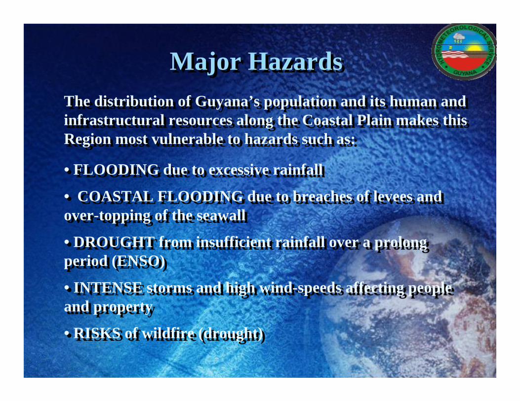
Major HazardsMajor HazardsThe distribution of Guyana’s population and its human and infrastructural resources along the Coastal Plain makes this Region most vulnerable to hazards such as:
• FLOODING due to excessive rainfall
• COASTAL FLOODING due to breaches of levees and over-topping of the seawall
• DROUGHT from insufficient rainfall over a prolong period (ENSO)
• INTENSE storms and high wind-speeds affecting people and property
• RISKS of wildfire (drought)
The distribution of Guyana’s population and its human and infrastructural resources along the Coastal Plain makes this Region most vulnerable to hazards such as:
• FLOODING due to excessive rainfall
• COASTAL FLOODING due to breaches of levees and over-topping of the seawall
• DROUGHT from insufficient rainfall over a prolong period (ENSO)
• INTENSE storms and high wind-speeds affecting people and property
• RISKS of wildfire (drought)

Impact of Hazards in GuyanaImpact of Hazards in Guyana

Impact of Hazards in GuyanaImpact of Hazards in Guyana
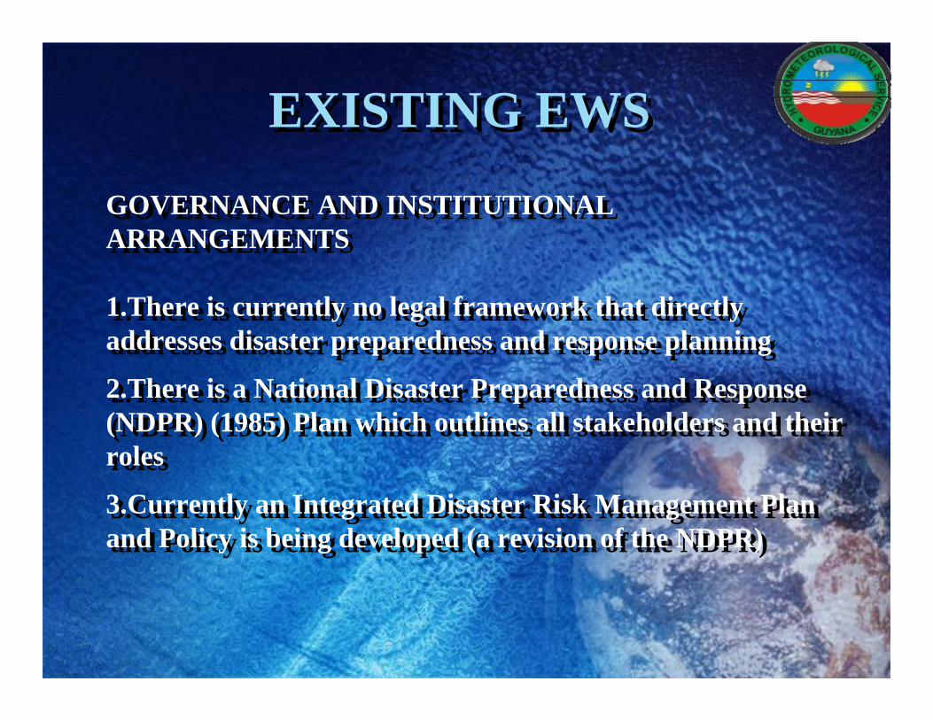
EXISTING EWSEXISTING EWS
GOVERNANCE AND INSTITUTIONAL ARRANGEMENTS
1.There is currently no legal framework that directly addresses disaster preparedness and response planning
2.There is a National Disaster Preparedness and Response (NDPR) (1985) Plan which outlines all stakeholders and their roles
3.Currently an Integrated Disaster Risk Management Plan and Policy is being developed (a revision of the NDPR)

EXISTING EWSEXISTING EWS
While there are no legal framework the components of EWS are exhibited in the work of the following organizations:
1.Monitoring & Warning: Hydrometeorological Service
2.Communication & Dissemination: Government Information Agency (GINA)
3.Preparedness & Response: Civil Defence Commission (CDC), National Drainage and Irrigation Authority (NDIA), Sea and RiverDefence Department (SRDD)
4. Knowledge: Guyana Lands & Surveys Commission (GL&SC), Guyana Bureau of Statistics, Guyana Red Cross, Environmental Protection Agency (EPA)

EXISTING EWSEXISTING EWSPLANNING PROCESS: National to local levels
1. The Civil Defence Commission (CDC) plays the lead role in national disaster preparedness and response. CDC chairs the National Disaster Platform which has the participation of all key agencies and stakeholders
2.At the local level there are ten (10) Regional Democratic Councils (RDCs) that are responsible for preparing their respective disaster preparedness and response plans under the supervision of the CDC
3. The preparedness and response plans of the RDCs also includes the community-level (Neighbourhood Democratic Councils)
PLANNING PROCESS: National to local levels
1. The Civil Defence Commission (CDC) plays the lead role in national disaster preparedness and response. CDC chairs the National Disaster Platform which has the participation of all key agencies and stakeholders
2.At the local level there are ten (10) Regional Democratic Councils (RDCs) that are responsible for preparing their respective disaster preparedness and response plans under the supervision of the CDC
3. The preparedness and response plans of the RDCs also includes the community-level (Neighbourhood Democratic Councils)
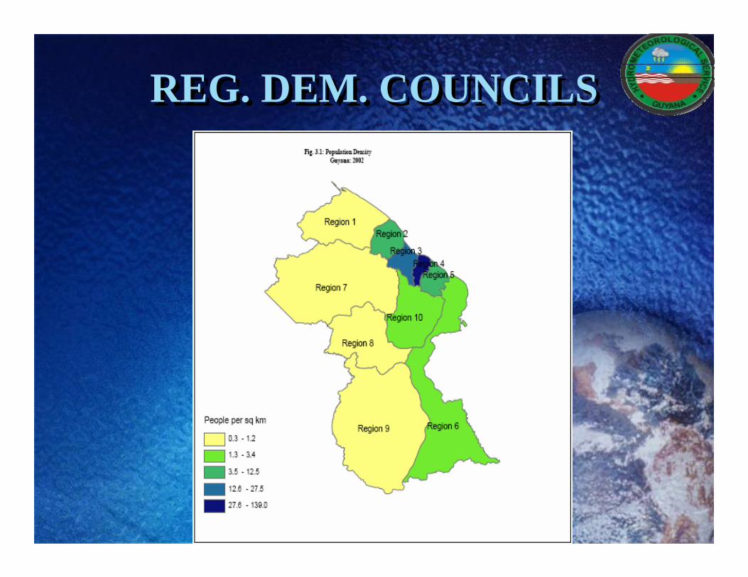
REG. DEM. COUNCILSREG. DEM. COUNCILS

EWS CHAIN OF COMMANDEWS CHAIN OF COMMANDPRESIDENT
NATIONAL DISASTER COORDINATOR
CIVIL DEFENCE COMMISSION
NDIAHYDROMET DEPARTMENT
SEA AND RIVER
DEFENCE
OTHER MINISTRIES AND
AGENCIES
GINA
GENERAL POPULATION
OTHER MEDIA
COMPANY

NMHS ROLE IN EWSNMHS ROLE IN EWS
•One of the key functions of the NMHS is the:
Provision of hydrological, meteorological, oceanographic and related data, information , forecasts, warnings, investigation and advisory services on a national as well as international scale.
• In this respect, the NMHS provides all weather-related data to the Civil Defence Commission and other stakeholders on a daily basis or as necessary.

METHOD FOR ISSUING EWsMETHOD FOR ISSUING EWs
1.Information is provided to the CDC by the relevant agency(ies) on any potential hazard. These agencies include the Hydrometeorological Service, NDIA, SRDD, Ministry of Health, etc.
2.Based on the information received and the approval of the Office of the President, the CDC prepares public advisories
3.On the advice of the National Disaster Coordinator these advisories are disseminated through the various communication means: print, radio, television, internet, SMS, etc

ISSUING EW MESSAGESISSUING EW MESSAGES
1.Only HIGH PROBABILITY (hazard) messages are publicly disseminated subject to the approval of the National Disaster Coordinator .
2.LOW and MEDIUM (hazard) messages are generally avoided.
3.There is no existing criteria for the determination of the magnitude of a particular risk. The extent of the risk is usually determined by meetings with the National Disaster Coordinator and the relevant monitoring/warning agency (ies).
4.There is no formal system to determine whether advisories were actually received by the general population

NMHS ROLE IN EWSNMHS ROLE IN EWS
MONITORING NETWORK (mainly coastal)
1.1 Doppler Weather Radar (400 km range)
2.27 Hydrological Stations (recording)
3. 157 rainfall stations (standard gauges)
4. 9 synoptic Weather Stations
5.Automatic Weather Stations
6.Indian specialist in Numerical Weather Prediction (7-day forecasts)
MONITORING NETWORK (mainly coastal)
1.1 Doppler Weather Radar (400 km range)
2.27 Hydrological Stations (recording)
3. 157 rainfall stations (standard gauges)
4. 9 synoptic Weather Stations
5.Automatic Weather Stations
6.Indian specialist in Numerical Weather Prediction (7-day forecasts)
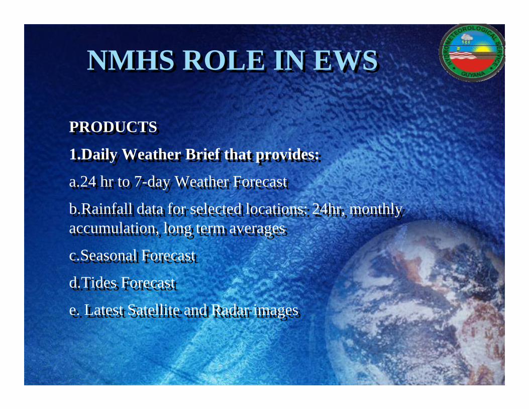
NMHS ROLE IN EWSNMHS ROLE IN EWS
PRODUCTS
1.Daily Weather Brief that provides:
a.24 hr to 7-day Weather Forecast
b.Rainfall data for selected locations: 24hr, monthly accumulation, long term averages
c.Seasonal Forecast
d.Tides Forecast
e. Latest Satellite and Radar images
PRODUCTS
1.Daily Weather Brief that provides:
a.24 hr to 7-day Weather Forecast
b.Rainfall data for selected locations: 24hr, monthly accumulation, long term averages
c.Seasonal Forecast
d.Tides Forecast
e. Latest Satellite and Radar images

NMHS ROLE IN EWSNMHS ROLE IN EWS
PRODUCTS
2.Website (www.hydromet.gov.gy) that provides:
a.24 hr
b.Weather Map
c.Archive of Monthly Weather Bulletins
d.Departmental Information
e. Latest Satellite and Radar images
f. Stakeholder links
PRODUCTS
2.Website (www.hydromet.gov.gy) that provides:
a.24 hr
b.Weather Map
c.Archive of Monthly Weather Bulletins
d.Departmental Information
e. Latest Satellite and Radar images
f. Stakeholder links

NMHS ROLE IN EWSNMHS ROLE IN EWSPRODUCTS
3. National Television and Radio Broadcasts:
a.Television: once daily
b.Radio: 3- 5 times per day
c.Special programmes/briefs under extreme weather conditions
PRODUCTS
3. National Television and Radio Broadcasts:
a.Television: once daily
b.Radio: 3- 5 times per day
c.Special programmes/briefs under extreme weather conditions

NMHS ROLE IN EWSNMHS ROLE IN EWS
CURRENT PROJECTS:
1.Development of a National Water Information System (NWIS) in collaboration with McGill University (Canada) and the CIMH under the CARIWIN Project
2.Linking the Doppler Weather Radar with other radars in the Region through the CMO to create a mosaic
3.JICA Project – a flood prone pilot site/watershed was selected for the development of an early warning system. It is anticipated that the success of this project will allow for its replication in other watersheds
MAJOR CONSTRAINTSMAJOR CONSTRAINTS
1.Human Resources – lack of the full complement of trained personnel
2.Equipment and equipment maintenance
3.Public perception/trust
4.Need for improved integration and coordination
5.Lack of knowledge of roles and responsibilities/duplication of roles
6.Financing
1.Human Resources – lack of the full complement of trained personnel
2.Equipment and equipment maintenance
3.Public perception/trust
4.Need for improved integration and coordination
5.Lack of knowledge of roles and responsibilities/duplication of roles
6.Financing
THE FUTURE OF EWSTHE FUTURE OF EWS
1.Guyana concluded a study in March, 2010 in an effort to develop a formal multi-hazard early warning system
2.Guyana is engaging the Caribbean Catastrophe Risk Insurance Facility (CCRIF) on the possibility of introducing Agriculture Insurance based on excess rainfall
3.Guyana has been investing heavily improving its weather forecasting capacity. In 2009, four forecasters graduated from CIMH; an additional four will graduate in 2011.
4.The CDC is currently carrying out national training on disaster risk reduction and response
THANK YOU!THANK YOU!