modelling the mrb and srb using mesh impacts of climate … · processed for mrb and 1 is ......
TRANSCRIPT

Modelling the MRB and SRB using MESHImpacts of Climate ChangeCCRN Finale 2018
Saskatoon, Mar 5-6, 2018
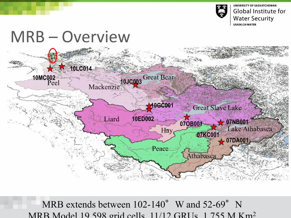
MRB – Overview
MRB extends between 102-140°W and 52-69°N
MRB Model 19,598 grid cells, 11/12 GRUs, 1.755 M Km2
10ED002
10JC003
10GC001
10LC014
07KC00107DA001
07NB00107OB001
10MC002

MRB – OVERVIEW (2)
Using WFDEI Precipitation and Observed Flows for
1/10/1980 – 30/9/2010
Sub-basin Outlet StationArea
(km2)
1980-2010
Precip
(mm/yr)
Flow (BCM/yr)% BIAS
Runoff
CoefficientOBS SIM
Athabasca Athabasca@Fort McMurray 132,057 532 17.9 19.7 10% 28%
Peace Peace@Peace Point 300,360 550 65.2 70.2 8% 42%
Lake Athabasca* Slave@Fitzgerald 597,219 523 103.9 122.1 17% 39%
Hay Hay@Hay River 51,531 476 3.6 7.7 114% 31%
Liard Liard nr Mouth 272,956 511 79.3 65.6 -17% 47%
Great Slave Lake+ Mackenzie@Fort Simpson 1,294,903 475 220.5 244.6 11% 40%
Great Bear Lake Great Bear River@outlet 146,629 331 16.8 17.3 3% 36%
Mackenzie# Mackenzie@Artic Red River 1,685,073 449 289.1 303.7 5% 40%

MRB Model Configuration Spatial resolution: 0.125°≈ 10 km
Checked drainage directions such that sub-basin areas/shapes are compatible with WSC shapes for about 270 gauges
11 GRUs (12 after splitting East/West) including shrubs, and Tundra grass - Glaciers switched on
Distributed Soil Texture (including organic) & Depth to Bedrock
New Routing Scheme (RTE)
21 Natural Lakes are explicitly included
Zoned reservoir scheme to represent Bennet Dam operations
Deep soil profile (24L – 50m) to represent Permafrost
Spinning Strategy was devised for Permafrost initialization
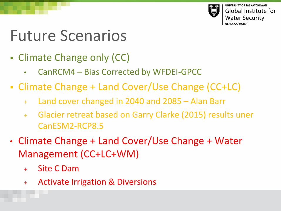
Future Scenarios Climate Change only (CC)
• CanRCM4 – Bias Corrected by WFDEI-GPCC
Climate Change + Land Cover/Use Change (CC+LC)
+ Land cover changed in 2040 and 2085 – Alan Barr
+ Glacier retreat based on Garry Clarke (2015) results unerCanESM2-RCP8.5
• Climate Change + Land Cover/Use Change + Water Management (CC+LC+WM)
+ Site C Dam
+ Activate Irrigation & Diversions

Future Scenarios – Climate 15 simulations of 0.44°(~50 km) + 1 finer resolution (0.22°~25
km) over North American Domain run (Historical 1950-2005 then
RCP 8.5 for 2006-2100) – CanESM2 downscaled by CanRCM4
Hourly data for 21 Variables downloaded (32 TB) for all members
Scripts developed to extract
desired basin, all members were
processed for MRB and 1 is
being run through
1st scenario has been BIAS
Corrected (all 7 variables)
based on WFDEI-GPCC
(correction is under progress
for GEM-CaPA)

Analysis of CanRCM4 Simulations - pr
15 Ensemble Members – MRB Average
Increasing Precipitation Trend starting
2010

Analysis of CanRCM4 Simulations - tas
15 Ensemble Members – MRB Average
Increasing Temperature Trend
accelerating starting 2000

Impact of BIAS-Correction

Future Scenarios – Land Cover/Use

Future Scenarios - Glaciers

Simulation TimelineDate/Period Type
1. Oct 1979 – Sep 1980 Spin-up (50-100 Cycles)
2. Oct 1979 – Sep 2010
Oct 1980 – Sep 2010
Open Loop
Analysis – Baseline Period
3. Oct 2010 – Sep 2020 Open Loop
Oct 2020 Land Use 2040 Introduced
4. Oct 2020 – Sep 2025 Open Loop - Land Use 2040 Smoothing
5. Oct 2025 – Sep 2055 Open Loop
Analysis – Near Future
6. Oct 2055 – Sep 2065 Open Loop
Oct 2065 Land Use 2085 Introduced
7. Oct 2065 – Sep 2070 Open Loop - Land Use 2085 Smoothing
8. Oct 2070 – Sep 2100 Open Loop
Analysis – Far Future

Average Hydrographs – CC Only

Flow Duration Curves – CC only

Flow Variability – CV – CC Only

Summary for flow changes
Sub-basin Outlet Station
2025-2055 2070-2100
Precip
(mm/yr)
%
Change
Flow
(BCM/yr)
%
ChangeRF
Precip
(mm/yr)
%
Change
Flow
(BCM/yr)
%
Change
Runof
Coeffidie
nt
AthabascaAthabasca@Fort
McMurray606 14% 22.6 15% 28% 665 25% 24.1 22% 27%
Peace Peace@Peace Point 623 13% 76.0 8% 41% 697 27% 80.1 14% 38%
Lake Athabasca* Slave@Fitzgerald 598 14% 137.0 12% 38% 661 26% 143.5 18% 36%
Liard Liard nr Mouth 573 12% 73.1 11% 47% 660 29% 84.0 28% 47%
Great Slave
Lake+ Mackenzie@Fort Simpson 545 15% 280.7 15% 40% 612 29% 311.7 27% 39%
Great Bear Lake Great Bear River@outlet 404 22% 22.4 29% 38% 468 41% 27.4 58% 40%
Mackenzie# Mackenzie@Artic Red
River520 16% 355.1 17% 41% 588 31% 400.4 32% 40%
Impacts on Permafrost - Current

Impacts on Permafrost – Mid 21st Century

Impacts of Permafrost – End of 21st Century

CC plus landcover – hot off the press
This shows the impact of
adding the Land
Cover/Glacier scenarios on
top of CC for the 2025-
2055 time slot.
The impact is generally
small, especially in terms
of magnitude but it has
some counter-balancing
effect on timing.

MESH model development for Saskatchewan River Basin (SaskRB) (Yassin et al., 2018 in prep) Watershed area of 405,864 km2
MESH model setup for the SaskRB at three spatial resolutions. The setup includes water management in the basin (irrigation, reservoir operation, and diversion).
Fourteen Land-Cover types / Group Response Unit (GRU)
Climate forcing data GEM-CaPA and WATCH for the period of 2002-2011
Multi-objective model calibration and validation on multiple streamflow stations. the optimal parameters are regionalized based on land cover unit across basin.

MESH model setup- Group response unit ( GRU)• Land-cover map from Canada Centre for Remote Sensing (CCRS) 2005 map. • Mapped onto five CLASS PFT: Evergreen Needle leaf Forest, Deciduous Broadleaf Forest,
Crop, Grass, Urban/barren land/impervious areas

Future of Saskatchewan River Basin Under Different Climate Change and Land-Cover Change Scenarios
Model calibration and validation on multiple streamflow stations. Model setup includes water management (irrigation, reservoir operation, diversion).
Land cover change: Irrigation area expansion in Alberta and Saskatchewan, depletion of alpine glaciers (Clark et al., 2015), and changes on other land covers
Future climate forcing: 15 CanRCM4 Simulations of 0.44°(~50 km) over North American Domain run (Historical 1950-2005 then RCP 8.5 for 2006-2100)
Simulation periods 1979-2010, 2025-2055, and 2070-2100
The analysis will include impact on snow accumulation, shift in spring melting period, runoff amount, irrigation water demand, diversion, reservoir water storage.

Future Scenario - Glacier Coverage Change
Global Land Ice Measurements from Space (GLIMS)
Source: [Clarke et al., 2015]
Clarke, G. K. C., A. H. Jarosch, F. S. Anslow, V. Radić, and B.
Menounos (2015), Projected deglaciation of western
Canada in the twenty-first century, Nat. Geosci., 8(5), 372–
377, doi:10.1038/ngeo2407.
2009
North Sask
Red Deer
Bow
Oldman
2040
North Sask
Red Deer
Bow
Oldman
2085
North Sask
Red Deer
Bow
Oldman

Future Scenarios- Irrigation Expansions
Irrigation Districts Planned Irrigation Districts
Saskatchewan:- Qu'Appelle and west side projects will potentially add 500,000
acres of irrigation area.
Alberta:- irrigation districts will expand by approximately 12% (200,000 acres) by
2025.

Changes on Precipitation: Long-term Daily Average1970-2010 2025-2055 2070-2100
Oldman near the mouth Bow near the mouth
Red Deer near Bindloss N. Sask @Edmonton
Battle near Sask boundary Sask. River at the Pas
1970-2010
2025-2055
2070-2100
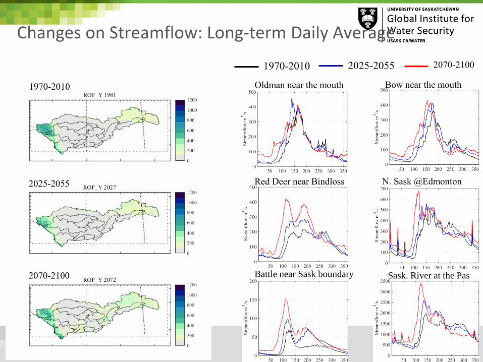
Changes on Streamflow: Long-term Daily Average
Oldman near the mouth Bow near the mouth
Red Deer near Bindloss N. Sask @Edmonton
Sask. River at the PasBattle near Sask boundary
1970-2010 2025-2055 2070-2100
1970-2010
2025-2055
2070-2100

Changes on ET: Long-term Daily Average1970-2010 2025-2055 2070-2100
Oldman near the mouth Bow near the mouth
Red Deer near Bindloss N. Sask @Edmonton
Battle near Sask. boundary Sask. River at the Pas
1970-2010
2025-2055
2070-2100

Changes on Streamflow Sub-basin Scale Summary

Changes on Soil Moisture: Long-term Daily Average1970-2010 2025-2055 2070-2100
Oldman near the mouth Bow near the mouth
Red Deer near Bindloss N. Sask. @Edmonton
Battle near Sask. boundary Sask. River at the Pas
Oldman near the mouth Bow near the mouth
Red Deer near Bindloss N. Sask. @Edmonton
Battle near Sask. boundary Sask. River at the Pas
Liquid (LQWS) Frozen (FRWS)

Early Conclusions We did it ! almost…..
Significant effort in model setup looking at dominant hydrological controls and land-cover has been completed.
• This includes calibration using GRU approach and landscape types
• Incorporation of most snow physics processes available in CLASS.
• Incorporation of Glaciers
• Incorporation of reservoirs and large lakes (routing only)
• Incorporation of land-cover change
Earlier snow melt, higher peaks at most locations across both basins – 1 climate trace only – very wet.
clear changes in permafrost
Land-Cover and anthropogenic change are formulated and need to be assessed in the model outputs.
Need to run larger sample of forcing
Model diagnostics still required

More to do……. CCRN Move to “ensemble” of future climate traces from RCM
• Require bias correction to WATCH for each trace
• Incorporate land-cover change
• Incorporate irrigation expansion
• Diagnose various state variables and possible change
• Compare to site models such as CRHM

More to do……. GWF Have we incorporated all the vertical water budget
processes and tested them at the landscape scale ?
• To some degree- but not evaluated systematically.• e.g. Glaciers not fully tested or dynamic
• Require continued collaboration between process teams and modelling community.
• Later transfer of water (on the landscape)
• We do not consider all processes. Boreal wetlands still not properly replicated, fill and spill could be improved. Shield areas not simulated well.