molonglo stage 3 development area: vegetation ... · molonglo stage 3 development area: vegetation...
TRANSCRIPT

Molonglo Stage 3 Development Area:
Vegetation Classification and Condition Assessment FINAL REPORT
Prepared for the ACT Land Development Agency
29 FEBRUARY 2016

Biosis Pty Ltd
This document is and shall remain the property of Biosis Pty Ltd. The document may only be used for
the purposes for which it was commissioned and in accordance with the Terms of the Engagement for
the commission. Unauthorised use of this document in any form whatsoever is prohibited.
Disclaimer:
Biosis Pty Ltd has completed this assessment in accordance with the relevant federal, state and local
legislation and current industry best practice. The company accepts no liability for any damages or loss
incurred as a result of reliance placed upon the report content or for any purpose other than that for
which it was intended.
© Biosis 2016 - Leaders in Ecology and Heritage Consulting - www.biosis.com.au i
Biosis offices
AUSTRALIAN CAPITAL TERRITORY
Canberra
Floor 1, Unit 3, 38 Essington Street
Mitchell ACT 2911
Phone: (02) 6102 1200
Email: [email protected]
NEW SOUTH WALES
Newcastle
39 Platt Street
Waratah NSW 2298
Phone: (02) 4911 4040
Email: [email protected]
Sydney
Unit 14 17-27 Power Avenue
Alexandria NSW 2015
Phone: (02) 9101 8700
Email: [email protected]
Wollongong
8 Tate Street
Wollongong NSW 2500
Phone: (02) 4201 1090
Email: [email protected]
QUEENSLAND
Brisbane
Suite 4 First Floor, 72 Wickham Street
Fortitude Valley QLD 4006
Phone: (07) 3014 1110
Email: [email protected]
VICTORIA
Ballarat
506 Macarthur Street
Ballarat VIC 3350
Phone: (03) 5304 4250
Email: [email protected]
Melbourne (Head Office)
38 Bertie Street
Port Melbourne VIC 3207
Phone: (03) 8686 4800
Fax: (03) 9646 9242
Email: [email protected]
Wangaratta
16 Templeton Street
Wangaratta VIC 3677
Phone: (03) 5718 6900
Email: [email protected]
Document information
Report to: ACT Land Development Agency
Prepared by: Nicola Trulock
Biosis project no.: 21593
File name: 21593.MolongloVegetationReview.FFA.DFT01.20160129.docx
Citation: Biosis 2016. Molonglo 3 Draft Preliminary Risk Assessment: Flora
Technical Specialist Services. Report for ACT Land Development Agency.
Authors: N Trulock, Biosis Pty Ltd, Sydney. Project no. 21593.
Document control
Version External reviewer Date issued
Draft version 01 Robert Speirs (Capital Ecology) 29/01/2016
Final version 01 Jane Raithby-Veall 29/02/2016
Acknowledgements
Biosis acknowledges the contribution of the following people and
organisations in undertaking this study:
ACT Land Development Agency: Project Managers Kerry Browning &
Daniel Santosuosso.
Robert Speirs (Principal Ecologist - Capital Ecology Pty Ltd) for
providing advice and a technical review of this report.
Department of Environment for access to the Protected Matters
Search Tool of the Australian Government
ACT Environment and Planning Directorate for access to the Nature
Conservation Act 2014 Threatened Species List.
ACT Government Territory and Municipal Services for access to the
ACT Pest Plants and Animals (Pest Plants) Declaration 2015(No 1).
Biosis staff members involved in this project were:
Nicola Trulock (field assessment, report writing)
Dr Samuel Reid (assistance in the field)
Chantel Benbow (background research, data entry)
James Shepherd and Lauren Harley (mapping)

© Biosis 2016 – Leaders in Ecology and Heritage Consulting II
Contents
Glossary...................................................................................................................................................................... iv
Summary .................................................................................................................................................................... v
1 Introduction .................................................................................................................................................... 1
1.1 Project background .............................................................................................................................................1
1.2 Scope of assessment ..........................................................................................................................................2
1.3 Location of the study area .................................................................................................................................2
2 Methods ........................................................................................................................................................... 6
2.1 Literature and database review ........................................................................................................................6
2.2 Site investigation ..................................................................................................................................................7
2.2.1 Vegetation classification and condition assessment........................................................................7
2.2.2 Fauna assessment ...................................................................................................................................8
2.2.3 Permits and Licences ...............................................................................................................................8
2.3 Limitations .............................................................................................................................................................8
2.4 Mapping .................................................................................................................................................................9
3 Legislative context ....................................................................................................................................... 10
3.1 Commonwealth ................................................................................................................................................. 10
3.1.1 Environment Protection and Biodiversity Conservation Act 1999 ............................................. 10
3.1.2 Australian Capital Territory (Planning and Land Management) Act 1988 (Cth) ...................... 10
3.1.3 National Capital Plan 2014 .................................................................................................................. 11
3.2 Territory Legislation.......................................................................................................................................... 11
3.2.1 Nature Conservation Act 2014 ........................................................................................................... 11
3.2.2 Planning and Development Act 2007 ............................................................................................... 11
3.2.3 ACT Government Territory Plan 2016 .............................................................................................. 13
3.2.4 Pest Plant and Animals Act 2005 ....................................................................................................... 13
4 Results ............................................................................................................................................................ 14
4.1 Landscape context ............................................................................................................................................ 14
4.2 Flora ..................................................................................................................................................................... 14
4.3 Vegetation communities ................................................................................................................................. 15
4.4 Ecological Constraints ...................................................................................................................................... 34
4.4.1 Hollow-bearing trees ............................................................................................................................ 34
4.4.2 Pink-tailed Worm-lizard habitat ......................................................................................................... 35
4.4.3 Waterways .............................................................................................................................................. 35
4.4.4 Declared Pest Plants ............................................................................................................................. 36
4.5 Threatened biota .............................................................................................................................................. 39
5 Ecological impacts and recommendations .............................................................................................. 41
5.1 Ecological impacts ............................................................................................................................................. 41
5.2 Recommendations ........................................................................................................................................... 43

© Biosis 2016 – Leaders in Ecology and Heritage Consulting III
6 Conclusion ..................................................................................................................................................... 47
References ................................................................................................................................................................ 49
Appendices ............................................................................................................................................................... 51
Appendix 1 Flora ........................................................................................................................................... 52
Appendix 2 Fauna ......................................................................................................................................... 57
Appendix 3 Figure 4. Detailed Map of Ecological Values ....................................................................... 59
Appendix 4 Figure 5. Detailed Map of Fauna Habitat Values ............................................................... 60
Tables
Table 1 Vegetation communities of the study area ........................................................................... 15
Table 2 Declared pest plant species recorded in the study area. ..................................................... 36
Table 3 Summary of threatened biota occuring or likely to occur in the study area ..................... 39
Table 4 Ecological values, impacts and recommendations ............................................................... 44
Table A.1 Flora species recorded from the subject site ......................................................................... 52
Table A.2 Vertebrate fauna recorded from the study area (current assessment) ............................. 57
Figures
Figure 1 Location of the study area, ACT ................................................................................................ 5
Figure 2 Ecological features of the study area, ACT ............................................................................. 37
Figure 3 Fauna habitat values within the study area, ACT ................................................................. 38
Plates
Plate 1 Moderately Modified Yellow Box – Red Gum Grassy Woodland .......................................... 17
Plate 2 Substantially Modified Yellow Box – Red Gum Grassy Woodland ....................................... 19
Plate 3 Severely Modified Yellow Box – Red Gum Grassy Woodland – Paddock Trees ................... 21
Plate 4 Moderately Modified – Natural Temperate Grassland ......................................................... 23
Plate 5 Substantially Modified – Native Pasture ................................................................................ 25
Plate 6 Tableland Riparian Woodland ................................................................................................. 27
Plate 7 Burgan Tableland Shrubland ................................................................................................... 28
Plate 8 Sedgeland .................................................................................................................................. 30
Plate 9 Exotic Pasture ........................................................................................................................... 32
Plate 10 Pine Plantation ......................................................................................................................... 33
Plate 11 Exotic Trees and Shrubs ........................................................................................................... 34

© Biosis 2016 – Leaders in Ecology and Heritage Consulting iv
Glossary
ACTPLA ACT Government Planning and Land Authority
AMS Adaptive Management Strategy
CBD Central Business District
CEEC Critically Endangered Ecological Community
Client The proponent of the proposed Molonglo Stage 3 Development, the ACT Land Development
Agency
DA Development Application
DBH Diameter at Breast Height
DoE Commonwealth Department of the Environment
EEC Endangered Ecological Community
EIS Environmental Impact Statement
EPBC Act Commonwealth Environment Protection and Biodiversity Conservation Act 1999
ESDD Environment and Sustainable Development Directorate
FUA Future Urban Area
HBT Hollow Bearing Tree
KTP Key Threatening Process
LDA ACT Government Land Development Agency
Locality The area within a 10 kilometre radius of the Molonglo Valley Stage 3 study area
MNES Matters of National Environmental Significance
NC Act ACT Nature Conservation Act 2014
NCP National Capital Plan
NES National Environmental Significance
NSW New South Wales
P&D Act ACT Planning and Development Act 2007
PPA Act ACT Pest Plant and Animals Act 2005
Proposal The Molonglo Stage 3 Development Area as proposed by the ACT Land Development Agency
SIC Significant Impact Criteria
Study area The area of impact for the proposed works
Territory Plan ACT Territory Plan 2016

© Biosis 2016 – Leaders in Ecology and Heritage Consulting v
Summary
Biosis Pty Ltd has been engaged by the ACT Land Development Agency (LDA) (the 'Client') to undertake flora
specialist technical services, specifically a vegetation classification and condition assessment, for the
proposed Molonglo Valley Stage 3 Urban Area, Molonglo, ACT (the Proposal).
Biosis understands that the ACT Government is currently undertaking a Preliminary Risk Assessment for a
Section 211 (s.211) exemption from requiring an Environmental Impact Statement (EIS) under the ACT
Planning and Development Act 2007 for the proposed development. In order to proceed with the Preliminary
Risk Assessment, the ACT Government requires further information regarding the existing vegetation within
the Molonglo Stage 3 Development Area between previously assessed patches of Yellow Box – Red Gum
Grassy Woodland and potential Pink Tailed Worm Lizard (PTWL) Aprasia parapulchella habitat (the study area).
Additional information is required regarding extent and nature of potential impacts associated with the
proposal using the Future Urban Area (FUA) boundary as defined by the ACT Territory Plan (Act Government
2016) which demarcates the outer limits of the proposed development.
Ecological values
Key ecological values identified within the study area include:
26.79 hectares of Box – Gum Woodland comprising of:
– 1.80 hectares (0.28 hectares within FUA boundary) of the CEEC Moderately Modified – Yellow Box
– Red Gum Grassy Woodland (EPBC and NC Act).
– 12.35 hectares (0.57 hectares within FUA boundary) of Substantially Modified Yellow Box – Red
Gum Grassy Woodland (not meeting the listing criteria for the threatened Box – Gum Woodland
community).
– 12.64 hectares (11.96 hectares within FUA boundary) of Severely Modified Yellow Box – Red Gum
Grassy Woodland – Paddock Trees (not meeting the listing criteria for the threatened Box – Gum
Woodland community).
33.44 hectares of Natural Temperate Grassland comprising of:
– 0.75 hectares (0.05 hectares within FUA boundary) of Moderately Modified - Natural Temperate
Grassland (EPBC Act and NC Act).
– 32.69 hectares (22.42 hectares within FUA boundary) of Substantially Modified – Native Pasture
(not meeting the listing criteria for the threatened Grassland community).
137.39 hectares of native vegetation comprising of:
– 56.03 hectares (none of which falls within the FUA boundary) of Tableland Riparian Woodland.
– 3.66 hectares (1.40 hectares within FUA boundary) of Burgan Tableland Shrubland.
– 2.87 hectares (0.95 hectares within FUA boundary) of Sedgeland.
– 17.15 hectares (3.07 hectares within FUA boundary) of Revegetated Land.
18 hollow-bearing trees (17 within the FUA boundary) all Blakely's Red Gum, Eucalyptus blakelyi.

© Biosis 2016 – Leaders in Ecology and Heritage Consulting vi
117.45 hectares (36.70 hectares within FUA boundary) of foraging, breeding and dispersal habitat for
the Pink-tailed Worm-lizard.
1 population of Leek Orchids (9 individuals) which are yet to be identified to species level (none of
which occur within the FUA boundary).
56.03 hectares (none of which falls within the FUA boundary) of vegetated Riparian Corridor providing
regional connectivity via the Molonglo and Murrumbidgee River.
Government legislation and policy
An assessment of the project against key biodiversity legislation and policy is provided and summarised
below.
Legislation / Policy Relevant ecological feature on site Permit / Approval
required
Environment
Protection and
Biodiversity
Conservation Act
1999
Matters of national Environmental Significance include presence of:
Yellow Box – Red Gum Grassy Woodland CEEC.
Natural Temperate Grassland EECs present.
Potential habitat for threatened fauna:
Pink-tailed Worm-lizard, Superb Parrot and Swift Parrot, Glossy Black
Cockatoo and Migratory species, Rainbow Bee-eater.
Potential habitat for threatened flora:
Hoary Sunray, Small Purple-pea, Tarengo Leek Orchid and Button
Wrinklewort.
N/A
ACT Nature
Conservation Act
2014
Ecological communities present include presence of:
Yellow Box – Red Gum Grassy Woodland CEEC.
Natural Temperate Grassland EECs present.
Potential habitat for threatened fauna:
Pink-tailed Worm-lizard, Superb Parrot and Swift Parrot and Little Eagle.
Potential habitat for threatened flora:
Hoary Sunray, Small Purple-pea, Tarengo Leek Orchid and Button
Wrinklewort
N/A
Fisheries Act 2000 Threatened fish with a moderate likelihood of occurrence include:
Macquarie Perch and Murray River Crayfish.
N/A
ACT Planning and
Development Act
2007
The study area contains:
Yellow Box – Red Gum Grassy Woodland CEEC.
Natural Temperate Grassland EECs present.
Potential habitat for threatened fauna:
Pink-tailed Worm-lizard, Superb Parrot and Swift Parrot, Glossy Black
Cockatoo and Migratory species, Rainbow Bee-eater.
Potential habitat for threatened flora:
Hoary Sunray, Small Purple-pea, Tarengo Leek Orchid and Button
Wrinklewort.
N/A
Pest Plants and
Animals Act 2005
The following noxious weeds are present within the subject site:
African Boxthorn, African Lovegrass, Blackberry, Box Elder, Chilean
Needle Grass, Cootamundra Wattle, Cotoneaster, False Acacia,
Under the Pest
Plants and Animals
Act 2005

© Biosis 2016 – Leaders in Ecology and Heritage Consulting vii
Legislation / Policy Relevant ecological feature on site Permit / Approval
required
Hawthorn, Patterson's Curse, Radiata Pine, Saffron Thistle, Willow, Scotch
Thistle, St Johns Wort and Sweet Briar. landowners are to
control all declared
weeds.
Recommendations
The primary recommendation for the proposed development to minimise impacts to ecological values within
the study area is to avoid or reduce removal of native vegetation and fauna habitat, and avoid disruption to
connectivity along the riparian corridors of Molonglo River and its tributaries.
The current proposal will require the removal of all vegetation present within the FUA boundary, with the
exception of vegetation existing within the three conservation areas, Kama Reserve, Molonglo River Park and
Block GG, as specified by the Molonglo Valley Plan for the Protection of Matters of Environmental Significance
(NES Plan).
This equates to the removal of 686.03 hectares of vegetation comprising of 40.72 hectares of native
vegetation, and 645.31 hectares of exotic vegetation including 0.28 hectares of the CEEC Moderately Modified
Yellow Box – Red Gum Grassy Woodland (EPBC and ACT NC Act and 0.05 hectares of EEC Moderately
Modified – Natural Temperate Grassland (EPBC and ACT NC Act).
The NES Plan for the Molonglo Valley Stage 3 Development has already incorporated the majority of the
ecological values previously identified within the study area into conservation zones which are to be
preserved in perpetuity. It is recommended that the hollow-bearing trees within the Severely Modified Yellow
Box – Red Gum Grassy Woodland – Paddock Trees community be retained along with the 0.28 hectares of
Moderately Modified - Yellow Box – Red Gum Grassy Woodland CEEC (EPBC and NC Act) and the 0.05
hectares of Moderately Modified - Natural Temperate Grassland EEC (EPBC Act). The remaining native
vegetation detected during the field survey comprising of Box-Gum Woodland (not conforming to the listed
community descriptions), Native Pasture and Burgan Tableland Scrubland is not considered to be significant.
Tableland Riparian Woodland is not affected by this Proposal.
Although the Leek Orchid population detected during the current survey do not occur within the FUA
boundary, it is recommended that the population undergoes a further targeted survey in late November–
early December to identify the plant to species level and rule out the presence of the threatened Tarengo
Leek Orchid Prasophyllum petilum. No further targeted surveys are recommended for threatened flora
species within the study area defined by this report.

© Biosis 2016 – Leaders in Ecology and Heritage Consulting 1
1 Introduction
1.1 Project background
Biosis Pty Ltd has been commissioned by the ACT Land Development Agency (the 'Client') to undertake a
vegetation classification and condition assessment of the proposed Molonglo Valley Stage 3 Development
Area, Molonglo Valley, ACT (the Proposal). The results of this assessment are to be used to inform the
preparation of a Preliminary Risk Assessment (PRA) to inform a s.211 exemption from the requirement to
prepare an Environmental Impact Statement (EIS) for the Proposal under the ACT Planning and Development
Act 2007 (P&D Act). A s.211 exemption allows the ACT Environment Minister (the ‘Minister’) to grant a
conditional EIS exemption if satisfied that previous studies have adequately identified the potential
environmental impacts associated with the Proposal.
An application for a s.211 exemption requires that the proponent provide sufficient information regarding
the Proposal including:
A description of the Proposal.
A Preliminary Risk Assessment which evaluates the significance of the potential impacts of the
Proposal.
Sufficient detail about the previous investigations and studies supporting the application, and
Details of public consultation undertaken.
Prior surveys have been undertaken of the vegetation communities existing in Kama Nature Reserve, located
adjacent to the western perimeter of the Molonglo Valley Stage 3 Development Area (the 'Development Area')
on land adjacent to William Hovell Drive. Surveys have also covered the Riparian Woodlands situated along
the Molonglo River riparian corridor (Eco Logical Australia 2009, 2013; Umwelt 2015a). These surveys
detected the presence of patches of White Box – Yellow Box – Blakely's Red Gum Grassy Woodland of varying
sizes and condition classes (meeting EPBC Act and NC Act criteria) and Natural Temperate Grassland (meeting
EPBC and NC Act criteria) within the Development Area. Previous surveys also detected the presence of
potential Pink-tailed Worm-lizard Aprasia parapulchella habitat (Osborne & Wong 2010).
The results of these surveys were used to inform the Molonglo Valley Plan for the Protection of Matters of
National Environmental Significance (MNES) (the ‘NES Plan’) (ACTPLA 2011) and the subsequently developed
Adaptive Management Strategy (AMS). The NES Plan was developed as part of an EPBC Act strategic
assessment to determine the potential impacts from the proposed development within the Molonglo Valley.
in September 2011, the NES Plan was endorsed by the Delegate for the Commonwealth Minister for the
Environment on 07 of October 2011.
The NES Plan outlines the ACT Government’s commitments in relation to avoidance and mitigation of
potential impacts to MNES. Where such impacts cannot be avoided or mitigated, the NES Plan details the
measures that will be implemented to offset residual impacts. Commitments include the preparation and
implementation of plans of management (Operation Plans) and adaptive management strategies and the
establishment of conservation areas which contain White Box - Yellow Box - Blakely's Red Gum Grassy
Woodlands and Derived Native Grasslands (synonymous with Yellow Box – Red Gum Grassy Woodland [ACT]
and henceforth referred to as Box – Gum Woodland), Natural Temperate Grassland of the Southern Tablelands
of NSW and the ACT (henceforth referred to as Natural Temperate Grassland) and Pink-tailed Worm-lizard
habitat. These conservation areas consist of Kama Nature Reserve which abuts the western perimeter of the

© Biosis 2016 – Leaders in Ecology and Heritage Consulting 2
Development Area and Molonglo River Park (comprising the riparian corridor of the Molonglo River and the
block designated as 'GG' located adjacent to the central eastern perimeter of the Development Area).
The vegetation community mapping created for the strategic assessment by EcoLogical Australia in 2009 and
used in the NES Plan was not intended to provide a vegetation condition benchmark. Accordingly, further
ecological surveys and mapping were undertaken during 2012-2013 with the objective of providing this
benchmark (EcoLogical Australia 2013). Subsequent surveys have confirmed and refined the initial
identification of the Box-Gum Woodland and Natural Temperate Grassland vegetation communities and
condition classes throughout the designated conservation areas specified under the NES Plan (EcoLogical
2009, 2013; Umwelt 2013a, 2013b, 2015a, 2015b). Whilst there is adequate current information available for
these areas, there is little information regarding the vegetation communities existing throughout the
remainder of the Development Area.
In order to proceed with the Preliminary Risk Assessment, the ACT Government requires further information
regarding the existing vegetation within the Development Area, in particular, the identification of vegetation
communities and species existing between patches of previously mapped Box – Gum Woodland and
potential Pink-tailed Worm-lizard habitat (the study area). Furthermore, information is required regarding
extent and nature of potential impacts associated with the proposal based on the Future Urban Area (FUA)
boundary as defined by the ACT Territory Plan (Act Government 2016) which has been used to demarcate the
outer limits of proposed construction works.
1.2 Scope of assessment
The objectives of this investigation are to:
Undertake a vegetation classification and condition assessment as per the methodology described in
Section 2.2.1.
Refinement of vegetation community mapping between areas of previously mapped Box – Gum
Woodland and Pink-tailed Worm-lizard habitat.
Mapping of vegetation communities as defined by the NC Act as 'native vegetation'.
Mapping of ecological values and constraints (e.g. threatened flora presence, substantial infestations
of noxious weeds, hollow-bearing trees, rock outcrops, waterways, etc.).
Review the implications for the Proposal of the relevant biodiversity legislation and policy.
Identify potential implications for the Proposal and provide recommendations to assist with
development design.
Provide recommendations for the Proposal, including justification for further assessment (if required)
and mitigation measures (if any) required for the Proposal to proceed, developed in accordance with
best practice and project requirements.
1.3 Location of the study area
The ‘study area’ for this investigation is the Molonglo Valley Stage 3 Development Area located in the
Molonglo Valley, approximately nine kilometres west of the Canberra CBD (Figure 1). The study area consists
of an approximately 500 hectare parcel of Government held and privately leased land formally known as
Molonglo Valley Registered Rural Blocks 3, 4, 5, 6, 7, 10, 12, 13, 14, 15, 16, 71, and Approved Rural Blocks 41,
43, 44, 45, 46, 47, 72, including the adjacent road reserves associated with William Hovell Drive and Coppins
Crossing Road. The study area is bound by William Hovell Drive to the north, Tuggeranong Parkway and the

© Biosis 2016 – Leaders in Ecology and Heritage Consulting 3
National Arboretum to the east, the Molonglo River to the south and Kama Nature Reserve to the west. The
study area is bisected by Coppins Crossing Road which runs in a generally north/south direction. The study
area has been divided into two halves for ease of field investigation and reporting, with the western half of
the study area encompassing land between Kama Nature Reserve and Coppins Crossing Road and the
eastern half of the study area consisting of the land between Coppins Crossing Road and the Tuggeranong
Parkway/the National Arboretum.
The land comprising the study area is proposed for release for future urban development with a view to
accommodating approximately 55,000 new residents over the next 30 years (ACTPLA 2011). The land
comprising the study area has been assigned the following zones according to the ACT Government Territory
Plan 2016:
RZ1 – Suburban.
CZ1 – Core Zone.
CZ4 – Local Centre.
NUZ4 – River Corridor.
CF – Community Facilities.
PRZ1 – Urban Open Space.
TSZ1 – Transport.
RZ3 – Urban Residential.
DES – Designated.
NUZ3 – Hills, Ridges and Buffer Areas.
The study area is within the:
South Eastern Highlands Bioregion
Murray-Darling River Basin (Murrumbidgee Catchment)
Molonglo Valley District (managed by Territory and Municipal Services, TAMS).
The study area presents with an east to south-east aspect and is relatively flat throughout its central portion,
becoming mildly undulating as the land rises in elevation towards the north, giving rise to low hills along the
northern margins. Low hills are also prevalent throughout the southern portion of the study area. Land
adjoining the banks of the Molonglo River presents with a west to south aspect as the land descends steeply
towards the span of the Molonglo River proper. Two powerline easements traverse the study area, one
located along the southern perimeter just north of the Molonglo River, crossing in a north-west/south-east
direction, and the other located along the eastern perimeter of the study area crossing in a north/south
direction.
The Molonglo River, which flows through Canberra, forms the southern boundary of the study area,
meandering across the site in an east/west direction. Two tributaries of the Molonglo River also traverse the
site, Deep Creek which extends along the western perimeter of the study area travelling in a north/south
direction and, Coppins Creek, traversing the eastern half of the study area in a north-east/south-west
direction.
Three conservation areas exist within close proximity to the study area, being Kama Nature Reserve which
abuts the western perimeter of the study area, Black Mountain Nature Reserve approximately one kilometre
to the north-east and Lower Molonglo Nature Reserve approximately 900 metres to the north-west. Lower
Molonglo Nature Reserve directly links with Woodstock Nature Reserve, the Murrumbidgee River Corridor
and Stony Creek Nature Reserve, facilitating connectivity for fauna species throughout the locality.
Soils throughout the majority of the study area comprise of the Burra transferral soil landscape (Jenkins 2000)
intergrading with a linear strip of the Williamsdale transferral soil landscape which bisects the eastern half of

© Biosis 2016 – Leaders in Ecology and Heritage Consulting 4
the study area. The Paddys River alluvial soil landscape underlies the area of land occupied by the Molonglo
River. The Burra transferral soil landscape occurs extensively throughout the Canberra Lowlands including
the western foreshore of the Googong Reservoir and suburbs in the vicinity of Tuggeranong on rolling low
hills and alluvial fans and ridges with gently inclined slopes. The Burra transferral soil landscape is influenced
by the underlying geology of Silurian volcanics giving rise to shallow or moderately deep hardsetting soils
ranging from brown sandy loams on crests to red-brown sandy clays on midslopes and yellow light clay on
lower slopes and drainage lines. Burra transferral soils are strongly acidic with low soil fertility, low water
holding capacity, low permeability, and are susceptible to mass movement hazards as well as mild sheet or
gully erosion when surface vegetation is absent.
The Williamsdale transferral soil landscape occurs on the Canberra Lowlands including the Isabella Plains and
to the east of the Murrumbidgee River on undulating rises, fans, valley flats and depressions. The
Williamsdale transferral soil landscape is influenced by the underlying geology of Silurian volcanics in
association with alluvial material giving rise to deep brown or yellow loams to sandy clay loams on upper rises
and fans, moderately to very deep yellow sandy loams on lower rises and fan elements. Williamsdale
transferral soils are hardsetting, erosive and dispersible with acidic topsoils which experience seasonal
waterlogging.
The Paddys River alluvial soil landscape occurs on land associated with the high energy streams of the
Cullarin Upland, Clear Range and Canberra Lowlands including the Molonglo River on stream channels and
adjacent riparian corridors. The Paddys River alluvial soil landscape is influenced by the underlying geology of
Quaternary alluvium-gravel, sand, loam and clays giving rise to deep well drained soils ranging from brown
sands to yellowish brown loamy sand on riparian features to deep poorly drained yellowish brown loose sand
on stream or river beds. Paddys River alluvial soils are highly permeable, possess low fertility and present
with high erodibility especially in regards to gully erosion and wind erosion.

!(
!(
!(
!(
Barton Highway
Fede
ral H
ighwa
y
Villag
e Cree
k
Coppins Creek
Cliffs Creek
Deep C reek
Bu lgar Creek
WestonCreek
Holdens Creek
Sullivans Creek
Murrumbidgee River
Yarra lumla Creek
GinninderraCreek
Molonglo River
Belconnen
Woden Valley
Weston Creek
MoreeBourke
Parkes
CanberraSydney
WollongongAlbury
Ballina
BrokenHill
Newcastle
Acknowledgement: Topo (c) NSW Land and Planning Information (2011); Overivew (c) State of NSW (c.2003)
Matter: 21593Date: 15 January 2016,Checked by: NRT, Drawn by: LH, Last edited by: lharleyLocation:P:\21500s\21593\Mapping\
LegendStudy area
Scale 1:75,000 @ A4, GDA 1994 MGA Zone 55
0 750 1,500 2,250 3,000
Metres ±Biosis Pty LtdBallarat, Brisbane, Canberra, Melbourne, Newcastle, Sydney, Wangaratta & Wollongong
Figure 1: Location of the study area

© Biosis 2016 – Leaders in Ecology and Heritage Consulting 6
2 Methods
2.1 Literature and database review
In order to provide a context for the study area, records from the following databases were collated and
reviewed:
Commonwealth Department of the Environment (DoE) Protected Matters Search Tool for matters
protected by the EPBC Act (MNES).
ACT Pest Plants and Animals (Pest Plants) Declaration 2015 (No 1) search for noxious species
potentially occurring within the study area.
ACT Pest Plants and Animals (Pest Animals) Declaration 2005 (No 1) search for pest animals
potentially occurring within the study area.
Other sources of biodiversity information:
Relevant vegetation mapping derived from past assessments of the study area including:
– GIS data from the NES Plan (ELA 2009) and the ELA (2013) data used for the AMS, provided by
Todd Nowak (Economic Development Directorate); and
– GIS data for Kama Nature Reserve, provided by Umwelt, from the Umwelt (2010b) study.
The following reports, documents and plans were also reviewed:
ACT Flora and Fauna Committee final determinations for threatened biodiversity.
Molonglo Valley Plan for the Protection of Matters of Environmental Significance (NES Plan) (ACTPLA
2011).
Molonglo Valley Vegetation Survey - Baseline Condition Assessment (EcoLogical Australia, 2013).
Molonglo Stage 3 s.211 Application Supporting Documentation (Umwelt, 2015a).
Molonglo Stage 3 Ecological Values of the Kama Nature Reserve – Molonglo Stage 3 Outer Asset
Protection Zone – Vegetation Mapping Comparison (Umwelt, 2013a).
Ecological Values of the Kama Nature Reserve: Molonglo Stage 3 outer asset protection zone
(Umwelt, 2013b).
Survey Guidelines for Determining Lowland Vegetation Classification and Condition in the ACT (ACT
Government, 2012).
EPBC Act Policy Statement 3.5 – White Box – Yellow Box – Blakely’s Red Gum grassy woodlands and
derived native grasslands (DEH 2006a);
Action Plan No.27 – Woodlands for Wildlife: ACT Lowland Woodland Conservation Strategy (ACT
Government 2004); and
Action Plan No.28 – A Vision Splendid of the Grassy Plains Extended: ACT Lowland Native Grassland
Conservation Strategy (ACT Government 2005a).

© Biosis 2016 – Leaders in Ecology and Heritage Consulting 7
2.2 Site investigation
2.2.1 Vegetation classification and condition assessment
The vegetation classification and condition assessment was undertaken from 15 to 18 December 2015 by
Nicola Trulock (Botanist) and Dr Samuel Reid (Ecologist) of Biosis with a combined survey effort of eighty (80)
person hours. The vegetation classification and condition assessment was conducted in accordance with the
methodology provided in the ACT Survey Guidelines for Determining Lowland Vegetation Classification and
Condition in the ACT (ACT Government 2012). This survey methodology uses a combination of step point
transects and 20 x 20 metre quadrats for assessing native grassland and a combination of step point
transects, vertical and horizontal stratification including dominant species per strata layer and the random
meander technique (Cropper 1993) to assess grassy woodland and riparian woodland. Specific objectives of
the flora assessment were to assess the ecological values of the study area, determine the vegetation types
and communities within the study area, detect the presence of threatened species, populations and
ecological communities (biota) according to the EPBC Act and NC Act, and determine the nature and extent of
impacts associated with the Proposal.
General classification of native vegetation used in this report is based on the classification system in Keith
(Keith 2004) which uses three groupings of vegetation: vegetation formation, vegetation class and vegetation
type, with vegetation type the finest grouping. The grouping referred to in this report is vegetation type. The
vegetation community definition used for this report is based on the classification system provided in
Appendix B of the ACT Vegetation Survey Guidelines (ACT Government 2012) provided by the Client on 10
December 2015 which categorises vegetation into communities based on species composition and presence
of indicative species, soil and geological characteristics, climate and landscape position.
A list of flora species was compiled for each vegetation type and can be found in Section 4.3.
The general condition of native vegetation was observed as well as the effects of current seasonal conditions.
Notes were made on specific issues such as substantial declared pest plant infestations, evidence of
management works, impacts of the current grazing regime and the regeneration capacity of the vegetation.
The location of all hollow-bearing trees identified in the study area was recorded using a handheld GPS and
attributes such as species, DBH, habitat value and health were recorded in field data sheets.
Based on the results of the survey, each patch of Box - Gum Woodland was:
classified in accordance with the ‘Degree of Modification’ categories provided in Section 2.5 of ACT
Action Plan 27 – ACT Lowland Woodland Conservation Strategy; and
assessed against the flow chart provided in the EPBC Act Policy Statement 3.5 – White Box – Yellow
Box – Blakely’s Red Gum grassy woodlands and derived native grasslands (DEH 2006a).
Based on the results of the survey each patch of Natural Temperate Grassland was:
classified in accordance within the ‘Degree of Modification’ categories provided in Section 2.5 of ACT
Action Plan 28 -ACT Lowland Native Grassland Conservation Strategy; and
assessed for conformity with the EPBC Act listing criteria for the listed community using the method
outlined in A Method to Assess Grassy Ecosystem Sites: Using Floristic Information to Assess a Site's Quality
(Rehwinkel 2007).

© Biosis 2016 – Leaders in Ecology and Heritage Consulting 8
2.2.2 Fauna assessment
The fauna assessment involved the compilation of a list of all species incidentally observed during the
vegetation classification and condition assessment conducted from 15 to 18 December 2015 by Nicola
Trulock (Botanist) and Dr Samuel Reid (Ecologist) of Biosis over eighty (80) person hours. The fauna
assessment was opportunistic in nature, consisting of direct and indirect observation as well as identification
of habitat and resource availability. Additionally, likelihood of fauna presence was determined primarily on
the basis of the types and qualities of habitat(s) present. No active searches or targeted surveys for fauna
were undertaken during this vegetation classification and condition survey. Incidental observations of fauna
species were recorded with a view to characterising the values of the study area and the investigation was not
intended to provide a comprehensive survey of all fauna species that have the potential to utilise the study
area from time to time.
2.2.3 Permits and Licences
Biosis did not require a permit for this project from Territory and Municipal Services Directorate (TaMSD) as
there was no capture or handling of animals involved with the vegetation classification and condition
assessment. Biosis is covered by approval 11/355 from the NSW Animal Care and Ethics Committee (expiry
date 31 January 2017) which is valid within the ACT.
2.3 Limitations
Ecological surveys provide a sampling of flora and fauna at a given time and season. There are a number of
reasons why not all species will be detected at a site during survey, such as species dormancy, seasonal
conditions, ephemeral status of waterbodies and migration and breeding behaviours of some fauna. In many
cases these factors do not present a significant limitation to assessing the overall biodiversity values of a site.
The current vegetation classification and condition assessment was conducted at the start of summer, which
is an optimal time for survey as the majority of flora species were in flower and readily identifiable and
herpetofauna, avifauna and vertebrate mammals were not in torpor and were more likely to be active. The
field investigation was conducted on a series of consecutive days which were typically warm and clement at a
time when resident species were more likely to be active. The survey effort of eighty hours expended within
the study area is considered to be more than adequate to determine the presence of flora and fauna species
including the majority of threatened species with the exception of the Pink-tailed Worm-lizard as well as
resident amphibian and microbat species. These species require a targeted survey using specialised
techniques at specific times of day or specific seasons and are outside the scope of this assessment.
Database searches, and associated conclusions on the likelihood of species to occur within the study area, are
reliant upon external data sources and information managed by third parties.
The Molonglo River and associated tributaries, Deep Creek and Coppins Creek, traverse the study area. A
thorough survey for aquatic fauna was not conducted on these tributaries as assessment of the aquatic
ecological values was beyond the scope of this assessment. The implications of relevant biodiversity
legislation (e.g. EPBC / NC Act/ACT Fisheries Act) cannot be fully assessed without an assessment of aquatic
habitat and fauna. However, mitigation measures have been recommended that would be applicable to the
prevention of impacts to these waterways and their associated ecological values.
Impact areas used for this vegetation classification and condition assessment have been based on Lot DP
information acquired by Biosis in addition to a GIS shapefile of the FUA boundary as displayed in the ACT
Government Territory Plan (ACT Government 2016) provided by the Client. There are slight discrepancies
between the study area boundary and FUA boundary arising from the encroachment of the National
Arboretum, Canberra, into the FUA which is not yet reflected in the current version of the Territory Plan map

© Biosis 2016 – Leaders in Ecology and Heritage Consulting 9
layer. Therefore, the areas of the FUA which overlap the study area boundary are to be disregarded for the
purposes of this report.
2.4 Mapping
Mapping data was collected from the study area with a Samsung Tablet using ArcGIS Collector (uncorrected)
(GDA94) uploaded with an aerial photo of the study area produced by NearMap (NearMap 2015) in
combination with previous shapefiles detailing Pink-tailed Worm-lizard habitat patches, the study area
boundary and vegetation community mapping from previous ecological surveys, previously provided to
Biosis by the Client. A shapefile displaying the FUA boundary as defined by the Territory Plan (ACT Territory
2016), provided by the Client, was used to determine area of projected impacts associated with the Proposal.
Existing vegetation between patches of previously mapped Box - Gum Woodland was assigned into different
vegetation zones and represented as a polygon within ArcGIS Collector with all features relevant to the flora
assessment recorded in the accompanying attribute table. Field mapping of these vegetation zones was
refined using information derived from the accompanying field survey and then published in pdf form as part
of the final report. The accuracy of this mapping is subject to the accuracy of the GPS units (generally ± 7
metres) and dependent on the limitations of aerial photo rectification and registration.
Mapping has been produced using a Geographic Information System (GIS). Electronic GIS files containing the
relevant flora and fauna spatial data are available to incorporate into design concept plans. However, this
mapping may not be sufficiently precise for detailed design purposes.

© Biosis 2016 – Leaders in Ecology and Heritage Consulting 10
3 Legislative context
This section provides an overview of key biodiversity legislation and government policy considered in this
assessment. Where available, links to further information are provided. This section does not describe the
legislation and policy in detail and guidance provided here does not constitute legal advice.
3.1 Commonwealth
3.1.1 Environment Protection and Biodiversity Conservation Act 1999
The EPBC Act is the Australian Government's key piece of environmental legislation. The EPBC Act applies to
developments and associated activities that have the potential to significantly impact on Matters of National
Environmental Significance (NES) protected under the Act.
Matters of NES identified under the EPBC Act relevant to biodiversity and the Proposal include:
Wetlands of international importance (also known as 'Ramsar' wetlands);
Nationally threatened species and ecological communities; and
Migratory species.
Under the EPBC Act, activities that have the potential to result in significant impacts on Matters of NES must
be referred to the Commonwealth Minister for the Environment for assessment.
One CEEC, White Box – Yellow Box – Red Gum Grassy Woodland and Derived Native Grassland and one EEC
Natural Temperate Grassland, have been detected within the study area during prior surveys conducted by
Eco Logical (Eco Logical Australia 2009). Furthermore, the threatened species, Pink-tailed Worm-lizard,
Superb Parrot and Swift Parrot have also been detected within the study area during prior surveys (Eco
Logical 2009, 2013). Threatened species and ecological communities detected during this vegetation
classification and condition assessment that are protected by the EPBC Act are outlined in Section 0. An
assessment of the potential impacts to all Matters of NES under the provisions of the EPBC Act, including
recommendations, is provided in Section 5.
3.1.2 Australian Capital Territory (Planning and Land Management) Act 1988 (Cth)
The Australian Capital Territory (Planning and Land Management) Act 1988 (P&LM Act) is the legislative
instrument which allows the ACT Government to administer to lands within the ACT in conjunction with the
Commonwealth Government. Ownership of land within the ACT is retained by the Commonwealth
Government, being leased to occupiers as opposed to being sold freehold. Land managed by the
Commonwealth Government is referred to as National Land and is subject to the National Control Plan,
whereas land managed by the ACT Government is referred to as Territory Land and is subject to the Territory
Plan. The Commonwealth Government is also responsible for developments on Territory Land which has
been identified as possessing the special characteristics of the national capital, otherwise known as
'Designated Land‘. Other land under Commonwealth Government administration as part of the P&LM Act is
land designated as subject to ’Special Requirements‘ inasmuch as it is in the interests of the national capital to
ensure that the land be developed by the ACT and Commonwealth Government.
The P&LM Act also underpins the creation and maintenance of the National Capital Plan which sets out the
planning principles for all land in the ACT, specifically National Land, Designated Areas and Special
Requirement Areas.

© Biosis 2016 – Leaders in Ecology and Heritage Consulting 11
3.1.3 National Capital Plan 2014
The National Capital Plan (NCP) was established under Part III of the P&LM Act 1988. The primary objective of
the NCP is to ensure that all development within Canberra and the ACT is in accordance with their National
Significance as stated in section VII of the NCP (National Capital Authority 2014) with particular attention to:
The pre-eminence of the role of Canberra and the Territory as the National Capital.
Preservation and enhancement of the landscape features which give the National Capital its character and
setting.
Respect for the key elements of Walter Burley Griffin's formally adopted plan for Canberra.
Creation, preservation and enhancement of fitting sites, approaches and backdrops for national institutions
and ceremonies as well as National Capital Uses.
The development of a city which both respects environmental values and reflects the national concerns with
the sustainability of Australia's urban areas.
The NCP outlines specific conditions of planning, design and development and is restricted to National Land,
Designated Areas and Special Requirement Areas. The NCP also outlines land use codes accompanied with a
range of planning policies and permitted uses.
3.2 Territory Legislation
3.2.1 Nature Conservation Act 2014
The Nature Conservation Act 2014 (NC Act) is the chief legislation for the protection of native plants and
animals in the ACT and for the management of the conservation reserve network. The NC Act protects native
plants and animals, and provides management authority for conservation lands. The NC Act provides the
legal underpinning of nature conservation policy, management and action across the ACT. The NC Act
requires that potential impacts be assessed when there is the likelihood that a proposed action has the
potential to impact (directly or indirectly) upon NC Act listed biota. The NC Act also provides a definition for
'native vegetation' which is defined as present if:
Trees or shrubs indigenous to the area have a canopy cover of 10% or greater in any stratum; and/or
Native plants indigenous to the area comprise 50% or more of the cover of the understorey (grasses,
small shrubs, forbs, sedges etc.).
3.2.2 Planning and Development Act 2007
The Planning and Development Act 2007 (P&D Act) is the overarching legislation for assessing and
coordinating input into development applications. It determines which activities require development
approval and how to assess development proposals. Developments can be assessed by a Code, Merit or
Impact Track.
Pursuant to the P&D Act, a development proposal will be assessed via the ‘Impact Track’ and require the
preparation of an Environmental Impact Statement (EIS) if the development will have any of the impacts listed
under Part 4.3 of Schedule 4 of the Act.
The ecological impacts that trigger the requirement to prepare an EIS, of relevance to the proposal are:
Item 1. Proposal that is likely to have a significant adverse environmental impact on 1 or more of the following,
unless the conservator of flora and fauna provides an environmental significance opinion indicating that the
proposal is not likely to have a significant adverse environmental impact:

© Biosis 2016 – Leaders in Ecology and Heritage Consulting 12
(a) a critically endangered species;
(b) an endangered species;
(c) a vulnerable species;
(d) a conservation dependent species;
(e) a provisionally listed threatened species;
(f) a listed migratory species;
(g) a threatened ecological community;
(h) a protected native species;
(i) a Ramsar wetland;
(j) any other protected matter
Item 2. Proposal involving—
(a) the clearing of more than 0.5ha of native vegetation in a native vegetation area, on land that is
designated as a future urban area under the territory plan unless the conservator of flora and fauna
produces an environmental significance opinion that the clearing is not likely to have a significant adverse
environmental impact.
(b) the clearing of more than 5.0ha of native vegetation in a native vegetation area, on land that is
designated as a future urban area under the territory plan, unless the conservator of flora and fauna
produces an environmental significance opinion that the clearing is not likely to have a significant adverse
environmental impact.
Item 3. Proposal will result in a significant adverse environmental impact on a:
(c) a prescribed environmental value mentioned in the Territory Plan (Water use catchment general code)
of a natural waterway or aquifer.
When a proposed development requires an EIS, the Environment and Sustainable Development Directorate
(ESDD) prepares a scoping document that identifies all the matters that are to be addressed by the
proponent in the EIS.
With regard to the above, it is noted that amendments to the P&D Act (effective as at February 2011) have
provided the opportunity for an application to be made under Section 211(s.211) of the P&D Act for an
exemption from requiring an EIS from the ACT Conservator for Flora and Fauna for proposals that are
regarded as likely to result in a significant adverse environmental impact (in relation to the triggers identified
above). The Minister may grant an exemption is he is satisfied that previous studies have adequately
identified and addressed potential environmental impacts of the Proposal. If an EIS exemption is granted,
then the Proposal may progress towards the Development Application (DA) in the without the need for an
EIS.
The P&D Act also underpins the existence of the independent planning authority, ACT Planning and Land
Authority (ACTPLA), which is responsible for administering the Territory Plan and managing approvals for
development applications and the leasing of land. The P&D Act has also provided for the establishment of
the ACT Land Development Agency with the purpose of developing land for future urban release.

© Biosis 2016 – Leaders in Ecology and Heritage Consulting 13
3.2.3 ACT Government Territory Plan 2016
The aim of the ACT Government Territory Plan 2016 (Territory Plan) is to ensure that land is developed in a
manner which is not inconsistent with the National Capital Plan as well as ensuring that the planning and
development of the ACT is consistent with the primary objective of providing the people of the ACT with an
attractive, safe and efficient environment in which to live, work and partake in recreation (ACT Government,
2013).
The Territory Plan is also responsible for the management of land use codes and associated objectives for all
Territory land.
3.2.4 Pest Plant and Animals Act 2005
The Pest Plant and Animals Act 2005 (PPA Act) was enacted to provide for the identification, classification and
control of pest plants (noxious weeds) and animals. The PPA Act aims to reduce the negative impact of
noxious weeds and pest animal species on the economy, community and environment of the ACT by:
Establishing control mechanisms to prevent the establishment of significant new noxious weeds or
pest animal species in the ACT.
Preventing, eliminating or restricting the spread of particular significant noxious weeds and pest
animal species in the ACT.
Effectively managing widespread significant noxious weeds and pest animal species in the ACT.
Plants declared under the PPA Act are currently listed under Pest Plants and Animals (Pest Plants) Declaration
2015 (No 1) available from the TAMS website (ACT Government 2015). Pest animals declared under the PPA
Act are currently listed under Pest Plants and Animals (Pest Animals) Declaration 2005 (No 1) available from the
TAMS Website (ACT Government 2005b). The PPA Act is supported by a number of regulations and is
administered by TAMSD.
Noxious weeds are discussed further in Section 4.4.4 with recommendations for adhering to the PPA Act
provided in Section 5.2

© Biosis 2016 – Leaders in Ecology and Heritage Consulting 14
4 Results
The ecological features of the study area are described below and mapped in Figure 2. A more detailed
version of the ecological features overview map can be found in Appendix 3
4.1 Landscape context
The study area contains 22 separate patches of Box - Gum Woodland in varying condition classes which have
been categorised according to the ACT Government's 'Degree of Modification’ categories provided in Section
2.5 of ACT Action Plan 27(ACT Government 2004). The study area also contains 26 small patches of the
Natural Temperate Grassland community in varying condition classes which have been classified according to
the ACT Government ‘Degree of Modification’ categories provided in Section 2.5 of ACT Action Plan 28(ACT
Government 2005a). Riparian woodland and Sedgeland communities of varying quality line the banks of the
Molonglo River and its adjoining tributaries. These native vegetation communities are set within a matrix of
pastoral land which has been cleared of native vegetation and is currently used for livestock grazing and
Radiata Pine Pinus radiata plantations. Surrounding land uses include public open space, low density
residential, road infrastructure, environmental conservation and agricultural land.
The dominant geology within the study area consists of soils derived from Silurian volcanics comprising the
Burra and to a lesser extent, the Williamsdale Soil Landscapes (Jenkins, 2000), with soils characteristically
shallow on rises and hilltops to moderately deep on slopes and flats, hardsetting and ranging from loams on
crests and rises to clay loams along slopes and flats. Soils within depressions and along creek-lines displayed
a tendency to waterlogging, demonstrated by the presence of mesic species which will tolerate poorly
drained soils. Mild sheet and rill erosion was evident in disturbed areas and evidence of soil compaction
resulting from cattle was evident throughout high traffic zones of the study area, most notably in the vicinity
of both tributaries of the Molonglo River. Evidence of gully erosion was observed along the banks of the
Molonglo River and both tributaries.
The study area is directly linked to bushland within Kama Nature Reserve and the National Arboretum via the
contiguous nature of the patches of native vegetation within the conserved areas within the study area. The
study area displays indirect connectivity to nearby reserves including Yarramundi Reach Reserve and Black
Mountain Nature Reserve, both located approximately four kilometres to the east. Connectivity with the
greater region of Canberra is provided by the Molonglo River and its tributaries which flow through the study
area, connecting it to the Lower Molonglo Valley Nature Reserve, Woodstock Nature Reserve and the
Murrumbidgee River Corridor and facilitating the movement of fauna throughout the landscape.
4.2 Flora
Species recorded during the flora assessment are listed in Table A.1 of Appendix 1 (flora). Unless of particular
note, these species are not discussed further.
Nine important species (DEH 2006b) were recorded during the field investigation, Longhair Plume Grass
Dichelachne micrantha, Wild Sorghum Sorghum leiocladum, Kangaroo Grass Themeda triandra, Common
Everlasting Chrysocephalum apiculatum, Blue Devil Eryngium ovinum, Twining Glycine Glycine clandestina,
Variable Glycine Glycine tabacina, Wiry Dock Rumex dumosus and False Sarsparilla Hardenbergia violacea.
One population of nine Leek Orchids Prasophyllum spp. was identified within the study area during the field
assessment, none of which fall within the FUA boundary. The Leek Orchids were identified to genus level but

© Biosis 2016 – Leaders in Ecology and Heritage Consulting 15
could not be identified to species level as the time since flowering was too long to determine distinguishing
features of the species. The Leek Orchids were all observed to have flowered between late November and
the first few days of December. It is possible that the Leek Orchid found during the current field investigation
is the threatened Tarengo Leek Orchid Prasophyllum petilum and as such further assessment is
recommended to determine the identity of the orchid to species level.
No threatened flora species or populations were identified during the field investigation.
4.3 Vegetation communities
The vegetation existing throughout the majority of the study area has been modified by past disturbances
which include vegetation clearance, cattle grazing, pasture improvement, cropping, construction of rural
residences and associated outbuildings, fence installation and disturbances associated with the Radiata Pine
plantation. Further historical disturbance has occurred in association with the construction and maintenance
of the ActewAGL powerline easement as well as the construction of the surrounding roads.
Given the topographical/geological characteristics (elevation, aspect, geology etc) of the study area and the
floristic composition of the vegetation communities occurring within and adjoining the study area, it can be
determined that pre European settlement, the study area would have supported a mosaic of Box - Gum
Woodland on slopes and low hills, grading into Natural Temperate Grassland at lower elevations, specifically
along flats. Tableland Riparian Woodland would have lined the banks of the Molonglo River and its
tributaries.
A total of nine native vegetation communities and three exotic vegetation communities were identified within
the study area during the field investigation, of which only eight native vegetation communities and three
exotic vegetation communities occur within the FUA boundary. The native vegetation communities occurred
in disjunct patches in areas of the landscape which are not subject to grazing due to being fenced off, situated
amongst rocky outcrops or located atop hills or steep slopes.
The ecological features observed within the study area are outlined below (Table 1), separated into the
vegetation communities within which they occur (refer also to Figure 2 and Appendix 3).
Table 1 Vegetation communities of the study area
Moderately Modified Yellow Box – Red Gum Grassy Woodland
Extent within subject
site
1.80 hectares of the CEEC Moderately Modified Yellow Box – Red Gum Grassy Woodland
(meeting EPBC and NC Act listing criteria) was detected within the study area, of which 0.28
hectares occurs within the FUA boundary. The Moderately Modified - Yellow Box – Red
Gum Grassy Woodland community occurs in one medium sized patch atop a low hill
located to the north of the eastern half of the study area. The patch is surrounded by a
matrix of exotic pasture. Grazing impacts were evident throughout the margins of the
community, generally being confined to the slopes and areas lacking rocky outcrops.
Description The structural formation of the community consists of two well defined strata, a canopy
layer of woodland trees up to 15 metres tall and an understorey layer comprising of herbs
and grasses. A third under-developed strata was present within this community,
consisting entirely of exotic shrubs. The canopy layer is dominated by Yellow Box
Eucalyptus melliodora and Red Gum Eucalyptus blakelyi interspersed with occasional Apple
Box Eucalyptus bridgesiana, all of which were mature. No juvenile Eucalyptus species were
evident within this community, demonstrating a lack of active recruitment. The
understorey consists of a diverse array of native herbs and grasses including Kangaroo
Grass Themeda triandra, Wild Sorghum Sorghum Leiocladum, Weeping Grass Microlaena
stipoides, Ringed Wallaby Grass Rytidosperma caespitosum, Fuzzweed Vittadinia cuneata,

© Biosis 2016 – Leaders in Ecology and Heritage Consulting 16
Moderately Modified Yellow Box – Red Gum Grassy Woodland
Bidgee Widgee Acaena novae-zelandiae and Many-flowered Mat-rush Lomandra multiflora.
Important species found within this community include Wild Sorghum Sorghum
Leiocladum, Kangaroo Grass Themeda triandra, Common Everlasting Chrysocephalum
apiculatum, Blue Devil Eryngium ovinum, and Variable Glycine Glycine tabacina. Common
paddock weeds have integrated substantially into the margins of the Yellow Box-Red Gum
Grassy Woodland as its small patch size increases the impact of edge effects. Exotic
species most prevalent within the margins of the community are predominantly bird and
mammal dispersed species including Sweet Briar Rosa rubiginosa, Blackberry Rubus
fruticosus spp. aggregate, Wild Oats Avena fatua, Saffron Thistle Carthamus lanatus, St Johns
Wort Hypericum perforatum, Scotch Thistle Onopordium acanthium and Skeleton Weed
Chondrilla juncea.
Condition The patch of Yellow Box-Red Gum Grassy Woodland is in the Moderately Modified
Lowland Woodland condition class as the community has been modified by sporadic
bouts of grazing, has a canopy cover of 20%, possesses a moderate diversity and cover of
native species which includes disturbance tolerant species and a few grazing sensitive
species. The Yellow Box-Red Gum Grassy Woodland – Moderately Modified Lowland
Woodlands community contains a low density of weed species throughout the central
portion of the patch to a moderate density of exotic species along its margin resulting
from surrounding pastoral land use. The patch of remnant Moderately Modified - Yellow
Box-Red Gum Grassy Woodland displays high regenerative potential and may exhibit a
positive response to ecological restoration.
Associated soils, rainfall
and landscape position
The patch of Moderately Modified - Yellow Box – Red Gum Grassy Woodland is found atop
a hill between 620 – 627 metres above sea level located in the north of the eastern half of
the study area. Soils associated with this patch vegetation consist of the Burra transferral
soil landscape. The Molonglo Valley area experiences an annual average rainfall of 620
millimetres (BoM 2016a, 2016b).
Threatened ecological
community
Commonwealth EPBC Act: Critically Endangered
ACT NC Act: Endangered
EPBC Act Justification: The 1.80 hectares of Moderately Modified - Yellow Box – Red Gum
Grassy Woodland within the study area is deemed consistent with the definition under the
EPBC Act. The community meets the listing criteria in regards to size (1.80 hectares),
elevation (620-627 metres above sea level), annual rainfall (620 millimetres), soils (highly
fertile), structural composition (canopy overtopping an understorey containing grasses
and herbs), presence of the indicative canopy species (Yellow Box, Blakely's Red Gum and
Apple Box) and presence of important species (5 important species). However, the
vegetation was found to contain 11 out of the 12 native non-grass understorey species
required by the EPBC Act. The patch exhibited a great degree of diversity within the
understorey layer and had the survey been undertaken in Spring rather than Summer,
when certain species such as Early Nancy Wurmbea dioica are flowering, it is believed that
up to 14 species could have been recorded (Rob Spiers pers.comm. 29 January 2016).
Therefore a decision has been made to apply the precautionary principle and define this
community as consistent with EPBC Act listing criteria.
NC Act Justification: 1.80 hectares of the Moderately Modified - Yellow Box – Red Gum
Grassy Woodland found throughout the study area is consistent with the definition under
the ACT NC Act based on the presence of diagnostic species (20 species including the
presence of three characteristic canopy tree species), soil characteristics (soils displaying
relatively high fertility), and structural characteristics (canopy overtopping an understorey
of grasses and herbs) (ACT Government 1999, 2004).
Threatened species /
fauna habitat
Moderately Modified - Yellow Box – Red Gum Grassy Woodland within the study area
potentially provides moderate quality habitat for threatened flora including Hoary Sunray
Leucochrysum albicans var. tricolor, Small Purple-pea Swainsonia recta and Button
Wrinklewort Rutidosis leptorrhynchoides however, these species were not detected during

© Biosis 2016 – Leaders in Ecology and Heritage Consulting 17
Moderately Modified Yellow Box – Red Gum Grassy Woodland
the site assessment. The vegetation contains a variety of ecological features which may
form habitat for threatened fauna species within the locality including roosting, nesting
and foraging habitat for local and transient avifauna including the threatened Swift Parrot
Lathamus discolour and Superb Parrot Polytelis swainsonii. The vegetation does support
potential high quality habitat present for the Pink-tailed Worm-lizard Aprasia parapulchella
in the form of rocky outcrops of volcanic origin amidst a groundcover of native grasses and
herbs.
Plate 1 Moderately Modified Yellow Box – Red Gum Grassy Woodland
Substantially Modified Yellow Box – Red Gum Grassy Woodland
Extent within the study
area
12.35 hectares of Substantially Modified Yellow Box – Red Gum Grassy Woodland
(henceforth referred to as Substantially Modified Lowland Woodland) has been recorded
within the study area, of which 0.57 hectares occurs within the FUA boundary. The
Substantially Modified Lowland Woodland community occurs in a number of large to
medium sized patches along the roadside interface adjacent to William Hovell Drive.
Three other patches can be found within the study area, two small patches contiguous
with the Moderately Modified - Yellow Box – Red Gum Grassy Woodland, and one large
patch at the northern end of the western half of the study area. These patches are
generally surrounded by a matrix of exotic pasture, with the exception of the tracts of this
community which exist within the roadside interface. These patches of vegetation are
exposed to William Hovell Drive on their northern perimeter and exotic pasture on the
southern perimeter. Grazing impacts were evident throughout the margins of the
vegetation patches surrounded by exotic pasture, whereas the vegetation existing in the
roadside interface was highly edge affected.

© Biosis 2016 – Leaders in Ecology and Heritage Consulting 18
Substantially Modified Yellow Box – Red Gum Grassy Woodland
Description The structural formation of the community consists of two well defined strata, a canopy
layer of woodland trees up to 15 metres tall and an understorey layer comprising of herbs
and grasses. The canopy layer is dominated by Red Gum and Brittle Gum Eucalyptus
mannifera interspersed with occasional Yellow Box, of which all were mature. No juvenile
eucalypts were evident within this community, demonstrating a lack of active recruitment.
The understorey consists of a diverse array of native herbs and grasses which is
dominated by Rough Speargrass Austrostipa scabra. Other understorey species include
Common Wheatgrass Elymus scaber, Hairy Panic Panicum effusum, Longhair Plume Grass
Dichelachne crinita, Kangaroo Grass, Weeping Grass, Ringed Wallaby Grass, Tufted Bluebell
Wahlenbergia communis, Yanganbil Austrostipa bigeniculata and Mat-rush Lomandra
bracteata. Important species found within this community include Longhair Plume Grass
and Kangaroo Grass. Common paddock weeds have integrated substantially into the
margins of the Substantially Modified Lowland Woodland as its medium patch size and
exposure to continuous disturbance (vehicular traffic, cattle grazing etc.) increases the
impact of edge effects. Exotic species most prevalent throughout the community are
animal and water dispersed including Cocksfoot Grass Dactylis glomerata, Tall Fescue
Festuca elatior, Wild Oats, Phalaris Phalaris aquatica, Goatsbeard Tragopogon dubius,
Proliferous Pink Petrorhagia nanteuilii, Saffron Thistle, St Johns Wort, Prickly Lettuce Lactuca
serriola, Smooth Catsear Hypochaeris glabra and Buchan Weed Hirschfeldia incana.
Condition The patches of Yellow Box-Red Gum Grassy Woodland are in the Substantially Modified
Lowland Woodland condition class as the community has been substantially modified by
continuous grazing, and disturbances from road construction and vehicular traffic, have a
canopy cover of between 8-50%, possess poor species diversity and moderate cover of
native species which includes disturbance tolerant species only. The Substantially
Modified Lowland Woodland community contains moderate ingress of weed species
throughout the entire area of the patches which have resulted from surrounding pastoral
land use and vehicular traffic. These patches of Substantially Modified Lowland Woodland
display low regenerative potential and are unlikely to exhibit a positive response to
ecological restoration.
Associated soils, rainfall
and landscape position
The patches of Substantially Modified Lowland Woodland occur along the roadside
interface adjacent to William Hovell Drive, a small sized patch atop the hill on the northern
end of the eastern half of the study area, and a medium patch along the northern end of
the western half of the study area. Patches of Substantially Modified Lowland Woodland
occur between 580 – 626 metres above sea level and are located in patches along the
northern ends of the western and eastern half of the study area. Soils associated with the
patches of Substantially Modified Lowland Woodland comprise the Burra transferral soil
landscape. The Molonglo Valley area experiences an annual average rainfall of 620
millimetres (BoM 2016a, 2016b).
Threatened ecological
community
Commonwealth EPBC Act: Critically Endangered (Not Consistent)
ACTNC Act: Endangered (Not Consistent)
EPBC Act Justification: The 12.35 hectares of Substantially Modified Lowland Woodland
within the study area are not deemed consistent with the definition under the EPBC Act.
The Substantially Modified Lowland Woodland community meets the listing criteria in
regards to size (12.35 hectares), elevation (580-626 metres above sea level), annual rainfall
(620 millimetres), soils (highly fertile), structural composition (canopy overtopping an
understorey containing grasses and herbs), presence of the indicative canopy species
(Yellow Box, Blakely's Red Gum and Brittle Bark) and presence of important species (2
important species). However, the Substantially Modified Lowland Woodland community
did not contain at least 12 native non-grass understorey species (i.e. only 4 species were
recorded), thus failing to meet the full EPBC listing criteria.
NC Act Justification: 12.35hectares of the Substantially Modified Lowland Woodland found
throughout the study area is not consistent with the definition under the ACT NC Act as the

© Biosis 2016 – Leaders in Ecology and Heritage Consulting 19
Substantially Modified Yellow Box – Red Gum Grassy Woodland
community is in too degraded a condition to represent the EEC. This is based on the
presence of diagnostic species (16 species including the presence of three characteristic
canopy tree species), soil characteristics (soils displaying relatively high fertility), and
structural characteristics (canopy overtopping an understorey of grasses and herbs) (ACT
Government 1999, 2004).
Threatened species /
fauna habitat
Substantially Modified Lowland Woodland within the study area is considered too
degraded to provide habitat for threatened flora known or likely to occur within the locality
as they are considered grazing sensitive species. No threatened flora species were
detected during the site assessment. Substantially Modified Lowland Woodland contains a
variety of ecological features which may form habitat for threatened fauna species within
the locality including roosting, nesting and foraging habitat for local and transient avifauna
including the threatened Swift Parrot Lathamus discolour and Superb Parrot Polytelis
swainsonii. . One hollow-bearing tree was identified within this community which may
provide roosting habitat for local avifauna, microbats and arboreal mammals. In
particular, there is potential moderate quality habitat present for the Pink-tailed Worm-
lizard Aprasia parapulchella in the patch adjacent to the Moderately Modified - Yellow Box –
Red Box Grassy Woodland in the form of rocky outcrops of volcanic origin amidst a
groundcover of native grasses and herbs.
Plate 2 Substantially Modified Yellow Box – Red Gum Grassy Woodland
Severely Modified Yellow Box – Red Gum Grassy Woodland – Paddock Trees
Extent within the study
area
12.64 hectares of Severely Modified Yellow Box – Red Gum Grassy Woodland – Paddock
Trees (Henceforth referred to as Severely Modified Lowland Woodland – Paddock Trees)
were recorded within the study area, of which 11.96 hectares occurs within the FUA
boundary. The Severely Modified Lowland Woodland – Paddock Trees community occurs
in a number of large to medium sized patches on flat and elevated land within the central
section of the eastern half of the study area. These patches are surrounded by a matrix of
exotic pasture and evidence of grazing was evident throughout the entirety of this

© Biosis 2016 – Leaders in Ecology and Heritage Consulting 20
Severely Modified Yellow Box – Red Gum Grassy Woodland – Paddock Trees
community.
Description The structural formation of the community consists of two well defined strata, a canopy
layer of woodland trees up to 15 metres tall and an understorey layer comprising
predominantly of grasses. The canopy layer is dominated by Blakely’s Red Gum
intermixed with the subdominant Yellow Box, all of which were mature. No juvenile
eucalypts were evident within this community, demonstrating a lack of active recruitment.
The understorey consists of a depauperate representation of native grasses which are
severely impacted by competitive interactions with exotic species. Native species within
the understorey include Yanganbil, Windmill Grass Chloris truncata, Weeping Grass and
Wiry Dock Rumex dumosus. Important species found within this community include Wiry
Dock. Common paddock weeds have heavily infested the understorey of the Yellow Box-
Red Gum Grassy Woodland as its exposure to cattle and sheep grazing has reduced the
overall diversity to the extent that only grazing tolerant native species persist. Exotic
species most prevalent throughout the community are predominantly animal and water
dispersed including Barley Grass Hordeum leporinum, Rat's Tail Fescue Vulpia myuros, Wild
Oats, Phalaris, Vervain Salvia verbenaca, Saffron Thistle, Scotch Thistle, St Johns Wort, Sweet
Briar, African Boxthorn Lycium ferocissimum, White Horehound Marrubium vulgare and
Buchan Weed.
Condition The patches of Yellow Box-Red Gum Grassy Woodland are in the Severely Modified
Lowland Woodland condition class as the community has been severely modified by
continuous grazing from cattle and sheep over a long duration, has a canopy cover of less
than 10%, possesses extremely poor species diversity and low cover of native species,
which includes disturbance tolerant species only. The Severely Modified Lowland
Woodland – Paddock Trees community contains high ingress of weed species throughout
the entire area of the patches which have resulted from surrounding pastoral land use.
These patches of Severely Modified Lowland Woodland – Paddock Trees display negligible
regenerative potential and are highly unlikely to exhibit a positive response to ecological
restoration.
Associated soils, rainfall
and landscape position
The patches of Severely Modified Lowland Woodland – Paddock Trees occur on the
elevated land within the central section of the eastern half of the study area. These
patches of vegetation occur between 590 – 610 metres above sea level and are located just
north of the conservation area labelled GG in the NES Plan. Soils associated with the
patches of Severely Modified Lowland Woodland – Paddock Trees comprise the Burra
transferral soil landscape. The Molonglo Valley area experiences an annual average
rainfall of 620 millimetres (BoM 2016a, 2016b).
Threatened ecological
community
Commonwealth EPBC Act: Critically Endangered (Not Consistent)
ACT NC Act: Critically Endangered (Not Consistent)
EPBC Act Justification: The 12.64 hectares of Severely Modified Lowland Woodland –
Paddock Trees within the study area is not deemed consistent with the definition under
the EPBC Act. The Severely Modified Lowland Woodland – Paddock Trees community
meets the listing criteria in regards to elevation (580-626 metres above sea level), annual
rainfall (620 millimetres), soils (highly fertile), structural composition (canopy overtopping
an understorey containing grasses and herbs), presence of the indicative canopy species
(Yellow Box and Blakely's Red Gum) and presence of important species (one important
species). However, the Severely Modified Lowland Woodland – Paddock Trees community
did not contain a cover of over 50% native species, individual patches were not over 5
hectares in size and did not contain at least 12 native non-grass understorey species (i.e.

© Biosis 2016 – Leaders in Ecology and Heritage Consulting 21
Severely Modified Yellow Box – Red Gum Grassy Woodland – Paddock Trees
only one species was recorded), thus failing to meet the full EPBC listing criteria.
NC Act Justification: 12.64 hectares of the Severely Modified Lowland Woodland – Paddock
Trees found throughout the study area is not consistent with the definition under the ACT
NC Act as the community is in too degraded a condition to represent the EEC. This is
based on the presence of diagnostic species (6 species including the presence of two
characteristic canopy tree species), soil characteristics (soils displaying relatively high
fertility), and structural characteristics (canopy overtopping an understorey of grasses)
(ACT Government 1999, 2004).
Threatened species /
fauna habitat
Severely Modified Lowland Woodland – Paddock Trees within the study area is considered
too degraded to provide habitat for threatened flora known or likely to occur within the
locality as they are considered grazing sensitive species. No threatened flora species were
detected during the site assessment. The community contains a variety of ecological
features which forms habitat for threatened fauna species within the locality including
roosting, nesting and foraging habitat for local and transient avifauna including the
threatened Swift Parrot and Superb Parrot. In particular, there are a total of thirteen
hollow-bearing trees in this community which may form habitat for local avifauna,
microbats and arboreal mammals. One of these hollow-bearing trees was occupied by a
breeding pair of Sulphur-crested Cockatoos Cacatua galerita and their chick. There is
negligible habitat present for the Pink-tailed Worm-lizard in the patches of Severely
Modified Lowland Woodland – Paddock Trees as they do not contain rocky outcrops of
volcanic origin.
Plate 3 Severely Modified Yellow Box – Red Gum Grassy Woodland – Paddock Trees

© Biosis 2016 – Leaders in Ecology and Heritage Consulting 22
Moderately Modified – Natural Temperate Grassland (Dry Themeda Grassland)
Extent within the study
area
There are three small patches of Moderately Modified – Natural Temperate Grassland
consisting of Dry Themeda Grassland with a combined total of 0.75 hectares in the study
area. Only one of these patches comprising 0.05 hectares occurs within the FUA
boundary. These patches of Moderately Modified – Natural Temperate Grassland are
highly disjunct and tend to occupy sites which contained a high level of rocky outcrops.
Two are in locations which do not allow cattle grazing and one is protected from the worst
excesses of grazing by virtue of its rocky nature.
Description The structural formation of the community consists of one well defined strata, a
groundcover layer of native perennial grasses (approximately 40% cover) and herbs
(approximately 60% cover) up to 0.5 metres tall. The Groundcover layer supports native
grasses such as Kangaroo Grass along with co-dominants Wild Sorghum and Red Grass
Bothriochloa macra. Less dominant grasses include Hairy Panic, Longhair Plumegrass and
Common Wheatgrass with a few scattered Ringed Wallaby Grass, Rough Speargrass and
Yanganbil. These native grasses are interspersed with a variety of native herbs such as
Common Everlasting, Bidgee Widgee, Rice Flower Pimelea curviflora var. sericia, Fuzzweed,
Hairy Cutleaf Daisy Brachyscome rigidula, Climbing Saltbush Einadia nutans, Sprawling
Bluebell Wahlenbergia gracilis, Tufted Bluebell, Star Cudweed Euchiton sphaericus, Small St
Johns Wort Hypericum gramineum, Mat-rush and Many-flowered Mat-rush. A single
population of Leek Orchids, Prasophyllum spp. was detected in the patch near the area
being regenerated by Greening Australia. The Leek Orchid could not be identified to
species level as the inflorescence had degraded to the extent that identifying
characteristics could not be discerned. Common paddock weeds are present in small
numbers within this community, mainly along patch margins. Exotic species found within
this community are predominantly water and animal dispersed including Wild Oats, Soft
Brome Bromus molliformis, Proliferous Pink, Rat's Tail Fescue, Catsear Hypochaeris radicata
and Lambs Tongues Plantago lanceolata. Less common weeds include St Johns Wort,
Sweet Briar, Blanket Weed Verbascum thapsus, Vervain and Blackberry.
Condition The patches of Natural Temperate Grassland are in the Moderately Modified condition
class as the community has been modified by sporadic grazing by livestock in the past,
evident through the absence of more grazing sensitive species such as Bulbine Lily Bulbine
bulbosa and Common Billy-buttons Craspedia variabilis. The community possesses a
moderate to high species diversity and high cover of native species which includes some
grazing sensitive species. The Moderately Modified – Natural Temperate Grassland
community contains low ingress of weed species along patch margins resulting from
surrounding pastoral land use. These patches of Moderately Modified – Natural
Temperate Grassland display high regenerative potential and are likely to exhibit a positive
response to ecological restoration.
Associated soils, rainfall
and landscape position
The patches of Moderately Modified – Natural Temperate Grassland occur on slightly
sloping ground with a south to south-west aspect amongst rocky outcrops. These patches
of vegetation occur between 550– 565 metres above sea level. Soils associated with the
community comprise the Burra transferral soil landscape. The Molonglo Valley area
experiences an annual average rainfall of 620 millimetres (BoM 2016a, 2016b).

© Biosis 2016 – Leaders in Ecology and Heritage Consulting 23
Moderately Modified – Natural Temperate Grassland (Dry Themeda Grassland)
Threatened ecological
community
Commonwealth EPBC Act: Endangered
ACT NC Act: Endangered
EPBC Act Justification: The 0.75 hectares of Moderately Modified – Natural Temperate
Grassland within the study area is consistent with the definition under the EPBC Act. The
Moderately Modified – Natural Temperate Grassland community meets the listing criteria
in regards to elevation (550-565metres above sea level), soils (highly fertile), structural
composition (groundcover layer containing perennial grasses and up to 70% herbs),
presence of indicative species (11 species) and Floristic Value Scores (7, 12, 13 and 19).
NC Act Justification: 0.75 hectares of the Moderately Modified – Natural Temperate
Grassland found throughout the study area is consistent with the definition under the ACT
NC Act as the community is in moderate to high condition and represents the EEC. This is
based on the presence of diagnostic species (11species), soil characteristics (soils
displaying relatively high fertility), structural characteristics (canopy overtopping an
understorey of grasses) and Botanical Significance Rating (3) (ACT Government 2005a).
Threatened species /
fauna habitat
Moderately Modified – Natural Temperate Grassland within the study area is considered
to provide habitat for grazing sensitive threatened flora known or likely to occur within the
locality including Tarengo Leek Orchid, Small Purple-pea, Button Wrinklewort, Hoary
Sunray and Austral Toadflax Thesium australe. No threatened flora species were detected
during the site assessment with the exception of the leak orchid which may possibly be the
Tarengo Leek Orchid, this cannot be ruled out until the identity of the Leek Orchid found in
the study area is confirmed. The community contains a variety of ecological features
which may form foraging habitat for threatened fauna species within the locality in
particular, the Pink-tailed Worm-lizard as the community co-occurs with rocky outcrops of
volcanic origin.
Plate 4 Moderately Modified – Natural Temperate Grassland

© Biosis 2016 – Leaders in Ecology and Heritage Consulting 24
Substantially Modified – Native Pasture (Austrostipa Grassland)
Extent within the study
area
There is approximately 32.69 hectares of Substantially Modified – Native Pasture
consisting of Austrostipa Grassland within the study area, of which 22.42 hectares occurs
within the FUA boundary. This community comprises of multiple small, medium and large
patches within a matrix of exotic pasture. These patches of Substantially Modified – Native
Pasture are contiguous throughout the north-east corner of the eastern half of the study
area. The remainder of the patches within the eastern and western halves of the study
area have a highly disjunct distribution, some of which co-occur with rocky outcrops. All
patches of the community are subject to an intense grazing regime primarily by cattle and
sheep as well as native fauna such as the Eastern Grey Kangaroo Macropus giganteus.
Description The structural formation of the community essentially consists of two separate strata, an
upper groundcover layer of native perennial grasses up to 1 metre tall and a lower
groundcover layer of native perennial grasses (85%) and herbs (15%) up to 0.5 metres tall.
The upper groundcover layer is dominated by Yanganbil. The lower groundcover layer
comprises of a mixture of Rough Speargrass, Weeping Grass, Ringed Wallaby Grass,
Wallaby Grass Rytidosperma laeve, Common Wheatgrass and Red Grass, Fuzzweed, Daisy
Brachyscome heterodonta, Wiry Dock, Bidgee Widgee, Sprawling Bluebell, Oxalis Oxalis
perennans, Common Everlasting, Twining Glycine, Mat-rush and Many-flowered Mat-rush.
Common paddock weeds are present in moderate numbers throughout the community,
increasing to high ingress along patch margins. Exotic species found within this
community are predominantly water and animal dispersed including Wild Oats, Soft
Brome, Saffron Thistle, Scotch Thistle, Proliferous Pink, Rat's Tail Fescue, Barley Grass,
Phalaris, Cocksfoot Grass, St Johns Wort, Sweet Briar, Blanket Weed, Skeleton Weed,
Buchan weed, Vervain and Blackberry.
Condition The patches of Native Pasture are in the Substantially Modified condition class as the
community has been highly modified by continuous grazing by livestock in the past which
is evident through the abundance of grazing tolerant grass species and moderate levels of
weed ingress. The community possesses low species diversity although there is a high
cover of native species. These patches of Substantially Modified – Native Pasture display
low regenerative potential and are unlikely to regain their former diversity in response to
ecological restoration.
Associated soils, rainfall
and landscape position
The patches of Substantially Modified – Native Pasture occur on flat to slightly sloping
ground. The community occurs between 545– 620 metres above sea level. Associated
soils comprise the Burra and Williamsdale transferral soil landscapes. The Molonglo Valley
area experiences an annual average rainfall of 620 millimetres (BoM 2016a, 2016b).
Threatened ecological
community
Commonwealth EPBC Act: Endangered (Not Consistent)
ACT NC Act: Endangered (Not Consistent)
EPBC Act Justification: The 32.69 hectares of Substantially Modified – Natural Temperate
Grassland within the study area is not consistent with the definition under the EPBC Act.
The Substantially Modified – Native Pasture community meets the listing criteria in regards
to elevation (545-620 metres above sea level), soils (highly fertile), structural composition
(upper and lower groundcover) and cover abundance (>80%) but fails to meet the criteria
in regard to presence of indicative species (8 species) and Floristic Value Scores (between
1-3).
NC Act Justification: 32.69 hectares of the Substantially Modified – Native Pasture found
throughout the study area is not consistent with the definition under the ACT NC Act as the
community too degraded to represent the EEC. This is based on the low number of
diagnostic species (8 species), soil characteristics (soils displaying relatively high fertility),
and structural characteristics (upper and lower groundcover layer) and Botanical
Significance Rating (5) (ACT Government 2005a).

© Biosis 2016 – Leaders in Ecology and Heritage Consulting 25
Substantially Modified – Native Pasture (Austrostipa Grassland)
Threatened species /
fauna habitat
Substantially Modified – Native Pasture within the study area is not considered to provide
habitat for grazing sensitive threatened flora species and no threatened flora species were
detected during the site assessment. The community contains a variety of ecological
features, including one hollow-bearing tree which may form roosting habitat for avifauna,
microbats and arboreal mammals. Foraging habitat is available for threatened fauna
species within the locality in particular, the Pink-tailed Worm-lizard as the community
sometimes co-occurs with rocky outcrops of volcanic origin.
Plate 5 Substantially Modified – Native Pasture
Tableland Riparian Woodland
Extent within the study
area
There is approximately 56.03 hectares of Tableland Riparian Woodland lining the banks of
the Molonglo River and the majority of the length of its tributaries within the study area,
none of which occurs within the FUA boundary. This linear patch of Moderately Modified –
Natural Temperate Grassland has been fenced off from cattle and is protected from
grazing throughout the majority of its extent along the Molonglo River, with this stretch
being in moderate condition. The remaining Tableland Riparian Woodland lining the
tributaries of the Molonglo River is exposed to cattle and is more degraded as a result.
Description The structural formation of the community consists of three well defined strata, a canopy
layer overtopping a midstorey layer of shrubs and small trees and an understorey layer of
native perennial grasses and sedges up to a metre tall. The canopy layer is dominated by
River She-oak Casuarina cunninghamiana with occasional Snow Gum Eucalyptus pauciflora
and Brittle Gum dotted along the upper banks (only along the Molonglo River). Midstorey
species include Silver Wattle Acacia dealbata, Red-stemmed Wattle Acacia rubida, Black
Wattle Acacia mearnsii, Coast Myall Acacia binervia, Native Blackthorn Bursaria spinosa var.
lasiophylla and Prickly Teatree Leptospermum continentale. The understorey comprises of a
mixture of native grasses and sedges including Tall Sedge Carex appressa, Paddock
Lovegrass Eragrostis leptostachya, Common Fringe Sedge Fimbristylis dichotoma, Rush Jucus
australis, Blowngrass Lachnagrostis aemula, Oxalis, Common Reed Phragmites australis,

© Biosis 2016 – Leaders in Ecology and Heritage Consulting 26
Tableland Riparian Woodland
Tussock Grass Poa labillardierei, Weeping Grass, Ringed Wallaby Grass, Common
Wheatgrass, Kangaroo Grass and Cynoglossum australe. Weeds are present in moderate
abundance throughout the community, increasing towards the eastern end of the
Molonglo River and along the extents of the tributaries that are exposed to high levels of
livestock grazing. Exotic species found within this community are predominantly water
and animal dispersed including Box Elder Acer negundo, Willow Salix spp., Lombardy
Poplar Populus nigra, Wild Oats, Soft Brome, Spear Thistle Cirsium vulgare, Hemlock Conium
maculatum, Fleabane Conyza spp., Hawthorn Crataegus monogyna, Umbrella Sedge Cyperus
eragrostis, Phalaris, Cocksfoot Grass, Tall Fescue, St Johns Wort, Perennial Rye Grass Lolium
perenne, Watercress Nasturtium microphyllum and Annual Beardgrass Polypogon
monspeliensis.
Condition The patches of Tableland Riparian Woodland are in moderate condition throughout the
majority of the stretch along the Molonglo River with all structural layers intact and
displaying a low to moderate level of weed ingress. The Tableland Riparian Woodland
lining the tributaries of the Molonglo River exists as disjunct stretches of vegetation,
sometimes missing the midstorey or canopy strata layer and displaying a moderate to
high level of weed ingress. The community possesses low to moderate species diversity
and a moderate cover abundance of native species. The Tableland Riparian Woodland
lining the Molonglo River displays moderate regenerative potential and may improve in
response to ecological restoration. The vegetation along the tributaries of the Molonglo
River display low regenerative potential and are less likely to regain their former diversity
in response to ecological restoration.
Associated soils, rainfall
and landscape position
The Tableland Riparian Woodland occurring throughout the study area occupies the
riparian corridor associated with the Molonglo River and its tributaries. These patches of
vegetation occur between 500– 589 metres above sea level. Soils associated with the
Tableland Riparian Woodland comprise the Paddys River alluvial soil landscape. The
Molonglo Valley area experiences an annual average rainfall of 620 millimetres (BoM
2016a, 2016b).
Threatened ecological
community
Commonwealth EPBC Act: Not Listed
ACT NC Act: Not Listed
Threatened species /
fauna habitat
Tableland Riparian Woodland within the study area is not considered to provide habitat for
threatened flora species known or likely to occur within the locality and no threatened
species were detected during the site assessment. Tableland Riparian Woodland contains
a variety of ecological features which may form habitat for threatened species within the
locality including roosting and foraging habitat for the Glossy Black Cockatoo
Calyptorhynchus lathami and foraging habitat for the Little Eagle Hieraaetus morphnoides. In
particular, there is potential moderate quality habitat present for the Pink-tailed Worm-
lizard in the form of rocky outcrops of volcanic origin.

© Biosis 2016 – Leaders in Ecology and Heritage Consulting 27
Tableland Riparian Woodland
Plate 6 Tableland Riparian Woodland
Burgan Tableland Shrubland
Extent within the study
area
There is approximately 3.66 hectares of Burgan Tableland Shrubland in the study area
which is found growing in the vicinity of the Molonglo River between the Tableland
Riparian Woodland and Substantially Modified – Native Pasture communities. Of this, only
1.40 hectares occurs within the FUA boundary. This community was also found atop a hill
located in the southern end of the eastern half of the study area, as secondary regrowth
after prior vegetation clearance. The patches of Burgan Tableland Shrubland growing
within the vicinity of the Molonglo River have been fenced off and are protected from
livestock grazing.
Description The structural formation of the community consists of two well defined strata, a midstorey
layer of shrubs overtopping an understorey layer of native perennial grasses and herbs up
to 0.7 metres tall. The midstorey layer is dominated by a combination of Native
Blackthorn, Prickly Teatree, Red-stemmed Wattle, Black Wattle, Narrow-leaf Hopbush
Dodanaea viscosa subsp. angustissima. The understorey supports Kangaroo Grass,
Fuzzweed, Bidgee Widgee, Rough Speargrass, Yanganbil, Red Grass, Common Everlasting,
Common Wheatgrass, Native Geranium Geranium solanderi, Twining Glycine, Mat-rush,
Many-flowered Mat-rush and Tussock Grass. Exotic species found within this community
are predominantly water and animal dispersed including Rat's Tail Fescue, Blanket Weed,
Blackberry, Sweet Briar, Lambs Tongues, Phalaris, Proliferous Pink, Prickly Lettuce, St Johns
Wort, Buchan Weed, Fleabane, Soft Brome and Wild Oats.
Condition The patches of Burgan Tableland Shrubland are in moderate condition throughout the
majority of the stretch adjacent to the Molonglo River with all structural layers intact and
displaying a low to moderate level of weed ingress. The Burgan Tableland Shrubland atop
the low hill near the area of regeneration to the south of the eastern half of the study area
is in poor condition with a disjunct midstorey layer and a moderate level of weed ingress.
The community possesses low to moderate species diversity and a moderate cover

© Biosis 2016 – Leaders in Ecology and Heritage Consulting 28
Burgan Tableland Shrubland
abundance of native species. The Burgan Tableland Woodland lining the Molonglo River
and atop the hill near the area undergoing ecological restoration display moderate
regenerative potential and may improve in response to ecological restoration.
Associated soils, rainfall
and landscape position
The Burgan Tableland Shrubland occurring throughout the study area occupies the stretch
of land existing between the Tableland Riparian Woodland and the Substantially Modified
– Native Pasture, displaying a south to south-west aspect. The patch atop the hill near the
areas undergoing ecological restoration occurred on the southern, south-western and
south-eastern aspects of the hill. These patches of Burgan Tableland Shrubland occur
between 525– 576 metres above sea level. Soils associated with the Burgan Tableland
Shrubland comprise the Burra transferral soil landscape. The Molonglo Valley area
experiences an annual average rainfall of 620 millimetres (BoM 2016a, 2016b).
Threatened ecological
community
Commonwealth EPBC Act: Not Listed
ACT NC Act: Not Listed
Threatened species /
fauna habitat
Burgan Tableland Shrubland within the study area is not considered to provide habitat for
threatened flora species known or likely to occur within the locality and no threatened
species were detected during the site assessment. Burgan Tableland Shrubland contains a
variety of ecological features which may form habitat for generalist species within the
locality including roosting and foraging habitat for insectivorous birds and potential
foraging habitat for the Little Eagle. In particular, there is potential moderate quality
habitat present for the Pink-tailed Worm-lizard in the form of rocky outcrops of volcanic
origin.
Plate 7 Burgan Tableland Shrubland

© Biosis 2016 – Leaders in Ecology and Heritage Consulting 29
Sedgeland
Extent within the study
area
There is approximately 2.87 hectares of Sedgeland in the study area which occurs as a
linear strip lining the tributary of the Molonglo River traversing the study area adjacent to
its western and northern perimeter. A total of 0.95 hectares of Sedgeland occurs within
the FUA boundary. This community was also found fringing a dam located in the western
half of the study area on land which forms the property of "Glenloch".
Description The structural formation of the community essentially consists of two separate strata, an
upper groundcover layer of tall sedges and a lower groundcover layer of small sedges.
The upper groundcover layer is dominated by Common Fringe-sedge and Cumbungi
Typha spp. The lower groundcover layer included Tall Sedge, Swamp Dock Rumex brownii,
Bidgee Widgee, Rush, Willow Herb Epilobium billardiereanum, Cynoglossum austral and
Eleocharis acuta. Exotic species found within this community are predominantly water and
animal dispersed including Shivery Grass Briza minor, Umbrella Sedge, Cocksfoot Grass,
Tall Fescue, Yorkshire Fog Holcus lanatus, Nasturtium, Lambs Tongues, Phalaris, Annual
Speargrass, Fleabane, Wild Oats and Broadleaf Dock Rumex obtusifolius.
Condition The patches of Sedgeland are in poor to moderate condition throughout the majority of
the stretch along the tributary to the Molonglo River as well as along the perimeter of the
dam. The community has disjunct structural layers and has a moderate level of weed
ingress. The community possesses low to moderate species diversity and a moderate
cover abundance of native species. This community displays some regenerative potential,
relying mainly on aquatic birds as a seed source and may improve in response to
ecological restoration.
Associated soils, rainfall
and landscape position
The Sedgeland occurring throughout the study area occupies stretches of the Molonglo
River tributaries and the main dam of "Glenloch" which contain slow flowing or still water.
These patches of Sedgeland occur between 520– 592 metres above sea level. Soils
associated with Sedgeland comprise the Burra transferral soil landscape. The Molonglo
Valley area experiences an annual average rainfall of 620 millimetres (BoM 2016a, 2016b).
Threatened ecological
community
Commonwealth EPBC Act: Not Listed
ACT NC Act: Not Listed
Threatened species /
fauna habitat
The Sedgeland within the study area is not considered to provide habitat for threatened
flora species known or likely to occur within the locality and no threatened species were
detected during the site assessment. The Sedgeland community contains a variety of
ecological features which may form habitat for generalist species within the locality
including roosting and foraging habitat for aquatic birds and potential foraging habitat for
the Migratory Eastern Giant Egret Ardea modesta.

© Biosis 2016 – Leaders in Ecology and Heritage Consulting 30
Sedgeland
Plate 8 Sedgeland
Revegetated Land
Extent within the study
area
There is approximately 17.15 hectares of land within the study area which is currently
undergoing a revegetation and ecological restoration program administered by Greening
Australia. Of this, only 3.07 hectares of revegetated land occurs within the FUA boundary.
These revegetated zones are located within the south – western corner of the eastern half
of the study area adjacent to the Pine Plantation.
Description The structural formation of the community currently consists of a single stratum, a
ground-layer of revegetated groundcover plants and sapling shrubs and trees. Species
used for revegetation in this area include Broad – leaved Peppermint, Yellow Box, Red
Gum, Snow Gum, Red – stemmed Wattle, Silver Wattle, Kangaroo Grass, False Sarsparilla
Hardenbergia violacea, Many-flowered Mat-rush, Clustered Everlasting Chrysocephalum
semipapposum, Common Everlasting, Tussock Grass, Weeping Grass and Native Raspberry
Rubus parvifolius. Exotic species found within this community are predominantly animal
dispersed including Wild Oats, Vervain, Blanket Weed, Rat's Tail Fescue, Proliferous Pink,
Scotch Thistle, Prickly Lettuce, St Johns Wort, Buchan Weed, Fleabane and Saffron Thistle.
Condition The patches of Revegetated Land are in moderate condition throughout and are visibly
benefitting from the current regime of ecological restoration and post – revegetation
maintenance. The plantings all looked visibly healthy with no visible sign of plant
pathogens present. The community possesses low to moderate species diversity and a
moderate cover abundance of native species. This community displays regenerative
potential and is visibly benefitting from the revegetation and ecological restoration
program.
Associated soils, rainfall
and landscape position
The Revegetated Land occurring within the study area is mainly concentrated in the south
– west corner of the eastern half of the study area, within the western perimeter of the
Molonglo River Park. The Revegetated Land is creating a buffer zone between the

© Biosis 2016 – Leaders in Ecology and Heritage Consulting 31
Revegetated Land
Molonglo River Park and the Molonglo Valley Stage 3 Development Area. The Revegetated
Land occurs on land between 540– 592 metres above sea level. Soils associated with
Revegetated Land areas comprise the Burra transferral soil landscape. The Molonglo
Valley area experiences an annual average rainfall of 620 millimetres (BoM 2016a, 2016b).
Threatened ecological
community
Commonwealth EPBC Act: Not Listed
ACT NC Act: Not Listed
Threatened species /
fauna habitat
The Revegetated Land zones within the study area are not considered to provide habitat
for threatened flora species known or likely to occur within the locality and no threatened
species were detected during the site assessment. The Revegetated Land zones contain
very few ecological features which may form habitat for generalist species within the
locality, mainly limited foraging habitat for Eastern Grey Kangaroos Macropus giganteus and
other opportunistic species.
Exotic Pasture
Extent within the study
area
There is approximately 528.79 hectares of Exotic Pasture which covers the majority of the
study area, of which 408.44 hectares occurs within the FUA boundary. This community
predominantly occupies flats and low rises throughout the landscape. There were four
distinct sub-communities defined by their dominant species being;
Wild Oats dominant.
Rat's Tail Fescue dominant.
Phalaris dominant.
Barley Grass dominant.
Description The structural formation of the community consists of defined single strata, a groundcover
layer of perennial exotic grasses and herbaceous annuals. The groundcover layer is
dominated by Wild Oats, Barley Grass, Rat's Tail Fescue or Phalaris and contains the
following species Sheep Sorrel Acetosella vulgaris, Soft Brome, Scotch Thistle, Saffron
Thistle, Fleabane, Cocksfoot Grass, Goose Grass, Blanket Weed, Buchan Weed, St John’s
Wort, Catsear, Perennial Rye Grass and Blackberry. There are a small number of native
species as widely scattered individuals throughout this community including Cotton
Fireweed Senecio quadridentatus, Wiry Dock, Pigweed Portulaca oleracea, Weeping Grass,
Twining Glycine, Climbing Saltbush, Pink Bindweed Convolvulus erubescens, Rough
Speargrass and Yanganbil,
Condition The patches of Exotic Pasture are in poor condition throughout the majority of the study
area with only a few scattered grazing tolerant native grasses and herbs found in a widely
dispersed distribution. The remainder of the community is comprised completely of exotic
grasses and herbaceous annuals, accounting for approximately 98% cover. This
community displays negligible regenerative potential and is highly unlikely to improve in
response to ecological restoration.
Associated soils, rainfall
and landscape position
The Exotic Pasture occurring throughout the study area occupies vast stretches of land
which is subject to a continuous grazing regime. These patches of Exotic Pasture occur
between 520– 615 metres above sea level. Soils associated with the Exotic Pasture
community comprise the Burra and Williamsdale transferral soil landscapes. The
Molonglo Valley area experiences an annual average rainfall of 620 millimetres (BoM
2016a, 2016b).
Threatened ecological
community
Commonwealth EPBC Act: Not Listed
ACT NC Act: Not Listed
Threatened species /
fauna habitat
The Exotic Pasture within the study area is not considered to provide habitat for
threatened flora species known or likely to occur within the locality and no threatened
species were detected during the site assessment. The Exotic Pasture contains a variety of

© Biosis 2016 – Leaders in Ecology and Heritage Consulting 32
Exotic Pasture
ecological features which may form habitat for generalist species within the locality
including foraging habitat for the Little Eagle. Three Hollow-bearing trees were recorded
within this community which may form roosting habitat for local avifauna, arboreal
mammals and microbats. In particular, there is potential poor quality habitat present for
the Pink-tailed Worm-lizard in the form of rocky outcrops of volcanic origin.
Plate 9 Exotic Pasture
Pine Plantation
Extent within the study
area
There is approximately 264.07 hectares of Pine Plantation growing on the low hills and
slopes within the central and south-east sections of the eastern half of the study area and
190.65 hectares occurs within the FUA boundary.
Description The structural formation of the community consists of one well defined strata, a canopy
layer and one under developed strata consisting of a sparse and highly disjunct
groundcover layer. The canopy layer consisted entirely o f Radiata Pine Pinus radiata. The
groundcover layer comprised of Fleabane, Creeping Oxalis Oxalis corniculata, Blackberry
and Blanket Weed. A small number of native species were found within the groundcover
layer including Cotton Fireweed, Pigweed, Weeping Grass, Climbing Saltbush and Pink
Bindweed.
Condition The patches of Pine Plantation are in poor ecological condition throughout their extent
with only a few native species managing to retain a foothold primarily in patches where
sunlight is able to reach the ground as a result of breaks in the canopy. This community
displays negligible regenerative potential and is highly unlikely to improve in response to
ecological restoration.
Associated soils, rainfall
and landscape position
The Pine Plantation occurring throughout the study area occupies the majority of the land
within the south-east quarter of the study area. The patches of Pine Plantation occur
between 540– 615 metres above sea level. Soils associated with the Exotic Pasture
community comprise the Burra transferral soil landscape. The Molonglo Valley area

© Biosis 2016 – Leaders in Ecology and Heritage Consulting 33
Pine Plantation
experiences an annual average rainfall of 620 millimetres (BoM 2016a, 2016b).
Threatened ecological
community
Commonwealth EPBC Act: Not Listed
ACT NC Act: Not Listed
Threatened species /
fauna habitat
The Pine Plantation within the study area is not considered to provide habitat for
threatened flora species known or likely to occur within the locality and no threatened
species were detected during the site assessment. The Pine Plantation contains limited
ecological features which may form habitat for generalist species within the locality
including roosting and foraging habitat.
Plate 10 Pine Plantation
Exotic Trees and Shrubs
Extent within the study
area
There are approximately 70.24 hectares of Exotic Trees and Shrubs growing on low hills,
slopes and flats in close proximity to farm buildings and the Pine Plantation and 46.23
hectares occurs within the FUA boundary.
Description The structural formation of the community consists of two well defined strata, a canopy or
midstorey layer and an understorey layer consisting of predominantly exotic grasses and
herbaceous annuals. The canopy layer consists of a range of exotic ornamental species
depending on location of the patch including Black Locust Robinia pseudoacacia, Lemon
Citrus x limon, English Oak Quercus robur, Silky Oak Grevillea robusta, Lombardy Poplar,
Hawthorn and Radiata Pine. Blackberry completely dominates this community in areas
that contain a midstorey layer rather than a canopy. The groundcover layer comprises of
Rat's Tail Fescue, Barley Grass, Saffron Thistle, Blanket Weed, Wild Oats, Lambs Tongues
and Catsear. Native species occurring in this community are confined to Weeping Grass,
Ringed Wallaby Grass, Yanganbil, Rough Speargrass and Blakely's Red Gum.

© Biosis 2016 – Leaders in Ecology and Heritage Consulting 34
Exotic Trees and Shrubs
Condition The patches of Exotic Trees and Shrubs are in extremely poor ecological condition
throughout their extent with only two native species amounting to only a few widely
dispersed individuals. This community displays negligible regenerative potential and is
highly unlikely to improve in response to ecological restoration.
Associated soils, rainfall
and landscape position
The Exotic Trees and Shrubs community occurs in areas of land which exist in close
proximity to farm buildings and the Pine Plantation. These patches of Exotic Trees and
Shrubs occur between 545– 610 metres above sea level. Soils associated with the Exotic
Pasture community comprise the Burra transferral soil landscape. The Molonglo Valley
area experiences an annual average rainfall of 620 millimetres (BoM 2016a, 2016b).
Threatened ecological
community
Commonwealth EPBC Act: Not Listed
ACT NC Act: Not Listed
Threatened species /
fauna habitat
The Exotic Trees and Shrubs community within the study area is not considered to provide
habitat for threatened flora species known or likely to occur within the locality and no
threatened species were detected during the site assessment. The Exotic Trees and
Shrubs community contains limited ecological features which may form habitat for
generalist species within the locality including roosting and foraging habitat.
Plate 11 Exotic Trees and Shrubs
4.4 Ecological Constraints
4.4.1 Hollow-bearing trees
Eighteen hollow-bearing trees were recorded within the study area of which seventeen occur within the FUA
boundary (Figure 2). All of the hollow-bearing trees were Blakely's Red Gum and were estimated to be
between 150 to 250 years old. One hollow-bearing tree was observed to be occupied by a breeding pair of
Sulphur-crested Cockatoos Cacatua galerita and their chick.

© Biosis 2016 – Leaders in Ecology and Heritage Consulting 35
The majority of the hollow-bearing native trees within the Yellow Box – Red Gum Grassy Woodland present
throughout the study area and FUA boundary have a trunk diameter at breast height in excess of 50
centimetres with the largest in excess of 100 centimetres. The removal of these native Eucalypts will result in
a decrease in the foraging, roosting and nesting habitat available to local and transient hollow-dependent and
nectivorous fauna species, particularly the threatened Swift Parrot, Superb Parrot and the Regent Honeyeater
whose habitat requirements align closely with the Yellow Box – Red Gum Grassy Woodland vegetation
community footprint.
4.4.2 Pink-tailed Worm-lizard habitat
Areas of previously mapped Pink-tailed Worm-lizard habitat within the study area (Osborne and Wong 2010)
were assessed to determine vegetation community composition and condition. The results of this
assessment are reflected in the fauna habitat values mapping resulting from the field investigation (Figure 3:
Appendix 4). Only a few patches of previously mapped Pink-tailed Worm-lizard habitat were co-incident with
Box – Gum Woodland and Natural Temperate Grassland patches mapped during this vegetation classification
and condition assessment whereas a large proportion of the previously mapped patches corresponded with
Tableland Riparian Woodland and Burgan Tableland Shrubland. These patches could potentially form
moderate to high quality habitat for the Pink-tailed Worm-lizard. The remainder of the Pink-tailed Worm-
lizard habitat was aligned with Substantially Modified Native Pasture or Exotic Pasture, providing poor to
moderate quality potential habitat for this species. No Pink-tailed Worm-lizards were observed over the
duration of the field investigation.
4.4.3 Waterways
The Molonglo River traverses the study area for approximately 11 kilometres along the south-eastern,
southern and south-western boundaries. The Molonglo River and its riparian corridor have been fenced and
livestock excluded. The majority of the Molonglo River supports Tableland Riparian Woodland with the
exception of the extreme south-eastern corner which grades into the Exotic Trees and Shrubs community
with a dominance of European Ash Fraxinus excelsior, Box Elder and Willow. Evidence of gully, rill and sheet
erosion was detected within the riparian corridor of the Molonglo River, primarily in areas which have
experienced historical vegetation clearance and disturbance.
Two tributaries of the Molonglo River also traverse the study area, Deep Creek and Coppins Creek. Deep
Creek runs 2.4 kilometres from the northern boundary of the study area along the western perimeter before
flowing into the Molonglo River to the south. The other tributary, Coppins Creek, runs for 3.1 kilometres in a
south-western direction from the Dam located on the property, "Glenloch", to flow into the Molonglo River.
Both of these tributaries are unfenced and are freely accessed by livestock.
Deep Creek exists in higher ecological condition than Coppins Creek. Deep Creek supports the Sedgeland
community adjacent to the western perimeter of the study area and supports Tableland Riparian Woodland
along its northern reach. Deep Creek is host to a variety of weeds, predominantly Weeping Willow Salix
babylonica and Phalaris. Deep Creek displays gully, rill and sheet erosion along the reach adjacent to the
western perimeter of the study area, whereas the northern reach is relatively intact, although rill and sheet
erosion is present.
Coppins Creek is in a highly degraded condition predominantly supporting weeds such as Lombardy Poplar,
Hawthorn and Blackberry. Cattle were observed to have direct access to Coppins Creek and the resulting
severe soil compaction is evident. There is evidence of gully, rill and sheet erosion within close proximity to
Coppins Creek in areas which lack vegetation cover.

© Biosis 2016 – Leaders in Ecology and Heritage Consulting 36
4.4.4 Declared Pest Plants
During the site investigation sixteen (16) weeds declared noxious species under the Pest Plants and Animals Act
2005 were recorded. These noxious weeds are outlined in Table 2 below.
Table 2 Declared pest plant species recorded in the study area.
Scientific name Common name Class Management requirement
Lycium ferocissimum African Boxthorn
2,4 The pest plant must be suppressed and propagation and
supply is prohibited.
Eragrostis curvula African Love Grass
3 The pest plant must be contained.
Rubus fruticosus sp. agg. Blackberry 3,4 The plant is a pest plant which must be contained and whose
propagation and supply is prohibited.
Acer negundo Box Elder
4 The plant is a pest plant whose propagation and supply is
prohibited.
Nassella neesiana Chilean Needle Grass 3,4 The plant is a pest plant which must be contained and whose
propagation and supply is prohibited.
Acacia baileyana Cootamundra Wattle
4 The plant is a pest plant whose propagation and supply is
prohibited.
Cotoneaster glaucophyllus Cotoneaster
4 The plant is a pest plant whose propagation and supply is
prohibited.
Robinia pseudoacacia False Acacia
4 The plant is a pest plant whose propagation and supply is
prohibited.
Crataegus monogyna Hawthorn
3,4 The plant is a pest plant which must be contained and whose
propagation and supply is prohibited.
Echium plantagineum Patterson's Curse
3 The pest plant must be contained.
Pinus radiata Radiata Pine
3 The pest plant must be contained.
Carthamus lanatus Saffron Thistle 3 The pest plant must be contained.
Salix spp. Willow 2,4 The pest plant must be suppressed and propagation and
supply is prohibited.
Onopordium acanthium Scotch Thistle
3 The pest plant must be contained.
Hypericum perforatum St Johns Wort 3 The pest plant must be contained.
Rosa rubiginosa Sweet Briar 2,4 The pest plant must be suppressed and propagation and
supply is prohibited.

GF
GFGF
GFGFGFGFGFGFGF
GFGFGF
GF
GFGFGFGF
") ")
")
")
")")
")")
")")
")
")
")
")
")
")
")
")
")
")
")")")
")")
")
")
")
")")
#*#*#*#*#*#*#*#*#*
MccullochStreet
La d
yDenm
a n Drive
La dy De nm a n Drive
YarraGlen
P a rkesW ay
Caswe llDrive
Tu gg e ra nongP a rkwa y
Cott e r Road
CoppinsCrossing Roa d
Cou lte rDrive
P e scott La ne
Ram Roa d
Se e P la ce
Be ntha mStre e t
W illia m Hove llDrive
Du nsta nStre e t
Bindu b i Stre e t
Uria rra Roa d
Du nrossil Drive
Barre
njoeyDri
ve
The Bice nte nnia lNa tiona lTra il
The Bice nt e nnia lNa tionalTrail
Holdens Creek
Deep Creek
MolongloR iver
Weston
Creek
CoppinsCreek
Yar ralumla Creek
ACACIA INLET
WARRINA INLET
NURSERY BAY
YARRAMUNDIREACH
© Land and Property Information 2015
0 220 440 660 880 1,100
Me tre s
LegendStu dy a re aFUA b ou nda ry
GF Hollow-b e a ring tre e s#* Le e k Orchid (Prasophyllum Sp.)") Qu a dra tTra nse ct
Vegetation communityMode ra te ly Modifie d - Ye llow Box - Re d Gu m Gra ssy Woodla ndSu b sta ntia lly Modifie d Ye llow Box – Re d Gu m Gra ssy Woodla ndSe ve re ly Modifie d Ye llow Box – Re d Gu m Gra ssy Woodla nd – P a ddock Tre e sMode ra te ly Modifie d - Na tu ra l Te m pe ra t e Gra ssla ndSu b sta ntia lly Modifie d - Na tive P a stu reBu rg a n Ta b le la nd Shru b la ndTa b le la nd Ripa ria n Woodla ndSe dg e la ndP ine P la nta tionRe ve g e t a t e d La ndExotic Tre e s a nd Shru b sExotic P a stu re
Areas not surveyedNo a cce ssP re viou sly a sse sse d
±
Matter: 21593Date: 26 February 2016, Checked by: NRT, Drawn by: JMS, Last edited by: lharleyLocation:P:\21500s\21593\Mapping\21593_F2_VegComms_Overview
Biosis P ty LtdBa lla ra t, Brisb a ne , Ca nb e rra , Me lb ou rne ,
Ne wca stle , Sydne y, W a ng a ra t t a & Wollong ong
Sca le : 1:22,000 @ A3
Figure 2: Vegetationcommunities of Molonglo 3proposed development site,ACT - overview
Coordinate System: GDA 1994 MGA Zone 55
Acknowle dg e m e nts: Im a g e ry (c) LP I 2014; Ba se m a p © La nd a nd P rope rty Inform a tion 2015

")")
")
")
")
")
")
WilliamHove ll Drive
Molonglo River
Deep Creek
ST/A8/01
ST/A5/01
ST/A5/02
Q1/A5Q2/Ex1
Q10/A3
Q11/A5
Q12/A8
Q14/A5
© Land and Property Information 2015
0 50 100 150 200 250
Me tre s
LegendStudy are aFUA boundary
GF Hollow-be aring tre e s") QuadratT ranse ct
Vegetation communitySeve re ly Modifie d Ye llow Box – Re d Gum Grassy Woodland – Paddock T re e sSubstantially Modifie d - Native PastureTable land Riparian WoodlandSe dge landExotic Pasture
Areas not surveyedNo acce ssPre viously asse sse d
±
Matter: 21593Date: 02 March 2016, Checked by: NRT, Drawn by: JMS, Last edited by: lharleyLocation:P:\21500s\21593\Mapping\21593_F3_VegComms_Detail
Biosis Pty LtdBallarat, Brisbane , Canbe rra, Me lbourne ,
Ne wcastle , Sydne y, Wangaratta & Wollongong
3.7
3.5 3.6
3.9
3.4
3.8
3.1 3.2 3.3
3.10
Scale : 1:5,500 @ A3
Figure 3.1: Vegetationcommunities of Molonglo 3proposed development site,ACT - detail
Coordinate System: GDA 1994 MGA Zone 55
Ack nowle dge me nts: Image ry (c) LPI 2014; Base map © Land and Prope rty Information 2015

")
")
")
")
")
")
")
")
")
")
")
")
Coulte r Drive
CoppinsCrossingRoad
William Hovell Drive
Coulte rDrive
Deep CreekST/A2/02
ST/A6/04
RM/A1/02
ST/A3/01
ST/A2/03
RM/A1/01
RM/A6/04 RM/A2/02
ST/Ex1/02
ST/A5/03
ST/A1/01
Q4/Ex1
Q5/A5
Q6/A5
Q7/A5
Q8/Ex1
Q9/A3
Q24/A1
Q25/A1
cc
Q27/A2
Q28/A5
© Land and Property Information 2015
0 50 100 150 200 250
Me tre s
LegendStudy are aFUA boundary
GF Hollow-be aring tre e s") QuadratT ranse ct
Vegetation communityMode rate ly Modifie d - Ye llow Box - Re d Gum Grassy WoodlandSubstantially Modifie d Ye llow Box – Re d Gum Grassy WoodlandSe ve re ly Modifie d Ye llow Box – Re d Gum Grassy Woodland – Paddock T re e sSubstantially Modifie d - Native PastureBurgan Table land ShrublandTable land Riparian WoodlandRe ve ge tate d LandExotic Pasture
Areas not surveyedPre viously asse sse d
±
Matter: 21593Date: 02 March 2016, Checked by: NRT, Drawn by: JMS, Last edited by: lharleyLocation:P:\21500s\21593\Mapping\21593_F3_VegComms_Detail
Biosis Pty LtdBallarat, Brisbane , Canbe rra, Me lbourne ,
Ne wcastle , Sy dne y, Wangaratta & Wollongong
3.7
3.5 3.6
3.9
3.4
3.8
3.1 3.2 3.3
3.10
Scale : 1:5,500 @ A3
Figure 3.2: Vegetationcommunities of Molonglo 3proposed development site,ACT - detail
Coordinate System: GDA 1994 MGA Zone 55
Ack nowle dge me nts: Image ry (c) LPI 2014; Base map © Land and Prope rty Information 2015

GF
GFGF
GFGF GF
GF
")
")
WilliamHove llDriveBindubiStre et
Bindubi Stre e t Bindubi Stre e t
Bindubi Stre e t
Bindubi Stre et
Mack e llar Cre sce nt
Dwy e r Stre e t
BoothCre sce nt
T he Bice nte nnialNationalT rail
T he BicentennialNationalT rail
ST/A2/04
RM/A3/01
ST/A5/05 RM/A2/03Q29/A5
Q30/A5
© Land and Property Information 2015
0 50 100 150 200 250
Me tre s
LegendStudy are aFUA boundary
GF Hollow-be aring tre e s") QuadratT ranse ct
Vegetation communitySubstantially Modifie d Ye llow Box – Re d Gum Grassy WoodlandSe ve re ly Modifie d Ye llow Box – Re d Gum Grassy Woodland – Paddock T re e sSubstantially Modifie d - Native PastureSe dge landPine PlantationExotic T re e s and ShrubsExotic Pasture
Areas not surveyedPre viously asse sse d
±
Ma tter: 21593Da te : 02 M a rch 2016, Ch ecked by: N R T, D raw n by: JM S, Las t edited by: lh arleyLocation :P:\21500s\21593\M a pp in g\21593_F3 _VegCom m s_D etail
Biosis Pty LtdBallarat, Brisbane , Canbe rra, Me lbourne ,
Ne wcastle , Sy dne y, Wangaratta & Wollongong
3.7
3.5 3.6
3.9
3.4
3.8
3.1 3.2 3.3
3.10
Scale : 1:5,500 @ A3
Figure 3.3: Vegetationcommunities of Molonglo 3proposed development site,ACT - detail
Coordinate System: GDA 1994 MGA Zone 55
Ack nowle dge me nts: Image ry (c) LPI 2014; Base map © Land and Prope rty Information 2015

")")
")
Coppin
s Cros
singR
oad
Coppins Creek
Deep Creek
Molonglo River
Molonglo River
ST/A5/04ST/Ex1/01
Q3/Ex1Q13/A5
Q15/A5
© Land and Property Information 2015
0 50 100 150 200 250
Metres
LegendStudy areaFUA boundary
GF Hollow-bearing trees") Quadrat
TransectVegetation community
Substantially Modified - Native PastureTableland Riparian WoodlandSedgelandRevegetated LandExotic Trees and ShrubsExotic Pasture
Areas not surveyedNo access
±
Matter: 21593Date: 02 March 2016, Checked by: NRT, Drawn by: JMS, Last edited by: lharleyLocation:P:\21500s\21593\Mapping\21593_F3_VegComms_Detail
Biosis Pty LtdBallarat, Brisbane, Canberra, Melbourne,
Newcastle, Sydney, Wangaratta & Wollongong
3.7
3.5 3.6
3.9
3.4
3.8
3.1 3.2 3.3
3.10
Scale: 1:5,500 @ A3
Figure 3.4: Vegetationcommunities of Molonglo 3proposed development site,ACT - detail
Coordinate System: GDA 1994 MGA Zone 55
Acknowledgements: Imagery (c) LPI 2014; Basemap © Land and Property Information 2015

")
Copp
ins Cr
ossin
g Roa
d
Coppins Creek
RM/Ex3/02
ST/Ex1/02
ST/Ex3/01
ST/Ex3/02
RM/Ex3/01
© Land and Property Information 2015
0 50 100 150 200 250
Metres
LegendStudy areaFUA boundary
GF Hollow-bearing treesTransect
Vegetation communitySubstantially Modified - Native PastureBurgan Tableland ShrublandTableland Riparian WoodlandPine PlantationRevegetated LandExotic Trees and ShrubsExotic Pasture
Areas not surveyedPreviously assessed
±
Matter: 21593Date: 02 March 2016, Checked by: NRT, Drawn by: JMS, Last edited by: lharleyLocation:P:\21500s\21593\Mapping\21593_F3_VegComms_Detail
Biosis Pty LtdBallarat, Brisbane, Canberra, Melbourne,
Newcastle, Sydney, Wangaratta & Wollongong
3.7
3.5 3.6
3.9
3.4
3.8
3.1 3.2 3.3
3.10
Scale: 1:5,500 @ A3
Figure 3.5: Vegetationcommunities of Molonglo 3proposed development site,ACT - detail
Coordinate System: GDA 1994 MGA Zone 55
Acknowledgements: Imagery (c) LPI 2014; Basemap © Land and Property Information 2015

GFGF
GFGF
GF
GFGF
GF GF
GFGFGF
GF
GFGF
GF
Tug geranong Park way
Parkes Way
WilliamHovell Drive
LadyDenmanDrive
TheBicent
ennial National
Trail
ST/A3/03
ST/A3/02
RM/A3/02
RM/A3/01
© Land and Property Information 2015
0 50 100 150 200 250
Metres
LegendStudy areaFU A boundary
GF Hollow-bearing treesTransect
Vegetation communitySubstantially Modified Yellow Box – Red Gum Grassy WoodlandSeverely Modified Yellow Box – Red Gum Grassy Woodland – Paddock TreesSubstantially Modified - Native PasturePine PlantationRevegetated LandExotic Pasture
Areas not surveyedPreviously assessed
±
Ma tter: 21593Da te : 02 M a rch 2016, Ch ecked by: N R T, D raw n by: JM S, Las t edited by: lh arleyLocation :P:\21500s\21593\M a pp in g\21593_F3 _VegCom m s_D etail
Biosis Pty LtdBallarat, Brisbane, Canberra, Melbourne,
Newcastle, Sydney, Wang aratta & Wollong ong
3.7
3.5 3.6
3.9
3.4
3.8
3.1 3.2 3.3
3.10
Scale: 1:5,500 @ A3
Figure 3.6: Vegetationcommunities of Molonglo 3proposed development site,ACT - detail
Coordinate System: GDA 1994 MGA Zone 55
Ack nowledg ements: Imag ery (c) LPI 2014; Basemap © Land and Property Information 2015
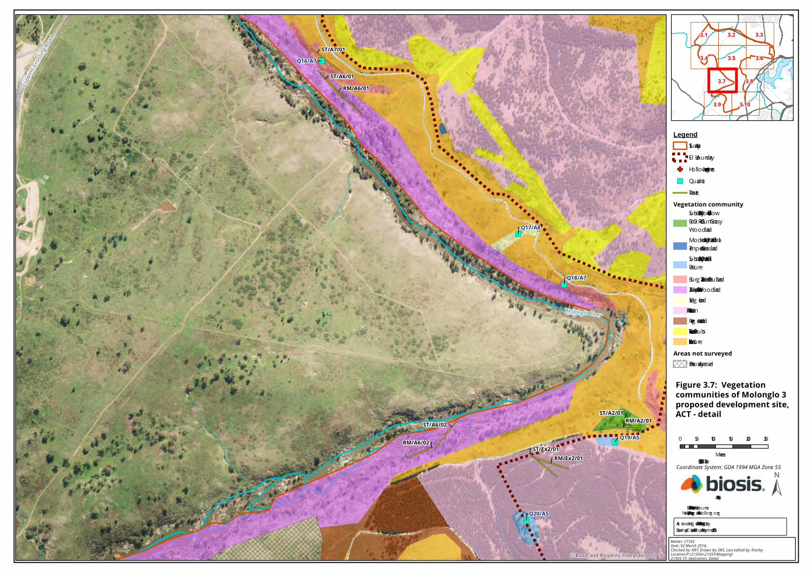
")
")
")
")
")
")
CoppinsCrossingRoad
Molonglo River
ST/A2/01
RM/A6/02
ST/A6/02
ST/Ex2/01
ST/A6/01
ST/A7/01
RM/Ex2/01
RM/A2/01
RM/A6/01
Q16/A7
Q17/A8
Q18/A7
Q19/A5
Q20/A5
© Land and Property Information 2015
0 50 100 150 200 250
Metres
LegendStudy areaFU A boundary
GF Hollow-bearing trees") QuadratTransect
Vegetation communitySubstantially Modified Yellow Box – Red Gum Grassy WoodlandModerately Modified - Natural Temperate GrasslandSubstantially Modified - Native PastureBurg an Tableland ShrublandTableland Riparian WoodlandSedg elandPine PlantationRevegetated LandExotic Trees and ShrubsExotic Pasture
Areas not surveyedPreviously assessed
±
Matter: 21593Date: 02 March 2016, Checked by: NRT, Drawn by: JMS, Last edited by: lharleyLocation:P:\21500s\21593\Mapping\21593_F3_VegComms_Detail
Biosis Pty LtdBallarat, Brisbane, Canberra, Melbourne,
Newcastle, Sydney, Wang aratta & Wollong ong
3.7
3.5 3.6
3.9
3.4
3.8
3.1 3.2 3.3
3.10
Scale: 1:5,500 @ A3
Figure 3.7: Vegetationcommunities of Molonglo 3proposed development site,ACT - detail
Coordinate System: GDA 1994 MGA Zone 55
Ack nowledg ements: Imag ery (c) LPI 2014; Basemap © Land and Property Information 2015

Tugger
anon
g Parkw
ay Lady Denman Drive
Lady D
enman
Drive
Dunross
il Drive
The B
i cente
nnial
Nat i o
nal T
ra il
The Bicentennial National Trail
MolongloRiver
Yarralumla Creek
© Land and Property Information 2015
0 50 100 150 200 250
Metres
LegendStudy areaFUA boundary
GF Hollow-bearing treesVegetation community
Burgan Tableland ShrublandPine PlantationRevegetated LandExotic Trees and ShrubsExotic Pasture
±
Matter: 21593Date: 02 March 2016, Checked by: NRT, Drawn by: JMS, Last edited by: lharleyLocation:P:\21500s\21593\Mapping\21593_F3_VegComms_Detail
Biosis Pty LtdBallarat, Brisbane, Canberra, Melbourne,
Newcastle, Sydney, Wangaratta & Wollongong
3.7
3.5 3.6
3.9
3.4
3.8
3.1 3.2 3.3
3.10
Scale: 1:5,500 @ A3
Figure 3.8: Vegetationcommunities of Molonglo 3proposed development site,ACT - detail
Coordinate System: GDA 1994 MGA Zone 55
Acknowledgements: Imagery (c) LPI 2014; Basemap © Land and Property Information 2015

#*#*#*#*#*#*#*#*#*
")
")
")
Uriar
raRo
ad
The Bicentennial National Trail
The Bicentennial National Trail
Holdens Creek
Westo
n CreekMolonglo River
RM/A6/03
ST/A6/03
Q21/A4Q22/A4
Q23/A7
© Land and Property Information 2015
0 50 100 150 200 250
Metres
LegendStudy areaFUA boundary
GF Hollow-bearing trees#* Leek Orchid (Prasophyllum Sp.)") Quadrat
TransectVegetation community
Moderately Modified - Natural Temperate GrasslandSubstantially Modified - Native PastureBurgan Tableland ShrublandTableland Riparian WoodlandPine PlantationRevegetated LandExotic Trees and ShrubsExotic Pasture
Areas not surveyedPreviously assessed
±
Matter: 21593Date: 02 March 2016, Checked by: NRT, Drawn by: JMS, Last edited by: lharleyLocation:P:\21500s\21593\Mapping\21593_F3_VegComms_Detail
Biosis Pty LtdBallarat, Brisbane, Canberra, Melbourne,
Newcastle, Sydney, Wangaratta & Wollongong
3.7
3.5 3.6
3.9
3.4
3.8
3.1 3.2 3.3
3.10
Scale: 1:5,500 @ A3
Figure 3.9: Vegetationcommunities of Molonglo 3proposed development site,ACT - detail
Coordinate System: GDA 1994 MGA Zone 55
Acknowledgements: Imagery (c) LPI 2014; Basemap © Land and Property Information 2015

Tuggeranong Parkway Cotter Road
ByrnesPlace
Morehead StreetKirkpatrick Street
Dunst
an Street
The Bicentennial National Trail
The Bicentennial National Trail
Weston
Creek
Molonglo River
© Land and Property Information 2015
0 50 100 150 200 250
Metres
LegendStudy areaFUA boundary
GF Hollow-bearing treesVegetation community
Burgan Tableland ShrublandTableland Riparian WoodlandPine PlantationRevegetated LandExotic Trees and ShrubsExotic Pasture
±
Matter: 21593Date: 02 March 2016, Checked by: NRT, Drawn by: JMS, Last edited by: lharleyLocation:P:\21500s\21593\Mapping\21593_F3_VegComms_Detail
Biosis Pty LtdBallarat, Brisbane, Canberra, Melbourne,
Newcastle, Sydney, Wangaratta & Wollongong
3.7
3.5 3.6
3.9
3.4
3.8
3.1 3.2 3.3
3.10
Scale: 1:5,500 @ A3
Figure 3.10: Vegetationcommunities of Molonglo 3proposed development site,ACT - detail
Coordinate System: GDA 1994 MGA Zone 55
Acknowledgements: Imagery (c) LPI 2014; Basemap © Land and Property Information 2015

© Biosis 2016 – Leaders in Ecology and Heritage Consulting 39
4.5 Threatened biota
Threatened biota includes all flora and fauna species, populations and ecological communities listed under
the EPBC Act and NC Act.
No areas of critical habitat for flora or fauna have been declared within the study area.
Two EECs, Box – Gum Woodland (NC Act) and Natural Temperate Grassland (EPBC and NC Act) were recorded
in the study area and FUA boundary during the field investigation.
No threatened flora or fauna species were detected during the site investigation, although one population of
a Leek Orchid which could not be identified to species level was detected within the study area but not
located within the FUA boundary. Confirmation of the species of this Leak Orchid is required as it has the
potential to the threatened Tarengo Leek Orchid. A summary of all threatened flora and fauna species which
have a medium or higher likelihood of occurring in the study area is provided in Table 3 below.
One Migratory species was recorded within the study area during the site investigation, being the Rainbow
Bee-eater Merops ornatus.
Table 3 Summary of threatened biota occuring or likely to occur in the study area
Name Status Area of value within the subject site
EPBC Act NC Act
Communities
Yellow Box – Red Gum
Grassy Woodland
CE E 1.80 hectares of the CEEC, Box - Gum Woodland (EPBC Act and NC Act)
occurs within the study area of which 0.28 hectares occurs within the FUA
boundary, predominantly on a hilltop which is inaccessible to cattle in the
north section of the study area.
Natural Temperate
Grassland
E E 0.75 hectares of the EEC, Natural Temperate Grassland (EPBC Act and NC
Act) is present within the study area of which 0.05 hectares occurs within
the FUA boundary (Section 4.3). Minimal weeds are present in the
understorey strata of the Natural Temperate Grassland community and it
exhibits moderate species diversity with a Flora Value score of 19. The
Natural Temperate Grassland is considered to be in moderate to good
condition.
Flora
Button Wrinklewort E E A total of 2.55 hectares of potential habitat for the Button Wrinklewort is
present in the form of Box - Gum Woodland EEC (NC Act) and the Natural
Temperate Grassland EEC patch (EPBC and NC Act) within parts of the
study area inaccessible to cattle. A total of 0.34 hectares occur within the
FUA boundary. It is noted however that this species is relatively
conspicuous when present and it has not been recorded within the study
area to date.
Hoary Sunray E - A total of 2.55 hectares of potential habitat for the Hoary Sunray is
present in the form of Box - Gum Woodland EEC (NC Act) and the Natural
Temperate Grassland EEC (EPBC and NC Act) within parts of the study
area inaccessible to cattle. A total of 0.34 hectares occur within the FUA
boundary.
Small Purple-pea E E A total of 2.55 hectares of potential Small Purple-pea habitat is present in
the form of Box - Gum Woodland EEC (NC Act) and the Natural Temperate
Grassland EEC (EPBC and NC Act) within parts of the study area

© Biosis 2016 – Leaders in Ecology and Heritage Consulting 40
Name Status Area of value within the subject site
inaccessible to cattle. A total of 0.34 hectares occur within the FUA
boundary.
Tarengo Leek Orchid CE E A total of 2.55 hectares of potential Tarengo Leek Orchid habitat is
present in the form of Box - Gum Woodland EEC (NC Act) and the Natural
Temperate Grassland EEC (EPBC and NC Act) within parts of the study
area inaccessible to cattle. A total of 0.34 hectares occur within the FUA
boundary.
Fauna
Glossy Black Cockatoo - V 56.03 hectares of potential foraging habitat for the Glossy Black Cockatoo
occurs within and in close proximity to the study area, none of which
occurs within the FUA boundary. Habitat features for this species include
riparian woodland containing Swamp She-Oak (Figure 3, Appendix 4).
Pink-tailed Worm-
lizard
V V The Pink-tailed Worm-lizard has previously been detected within the
study area and surrounds during past surveys (Osborne and Wong 2010,
Umwelt 2015b). A total of 117.46 hectares of potential Pink-tailed Worm-
lizard habitat is present in the form of rock outcrops of Silurian volcanic
origin combined with Natural Temperate Grassland EEC (EPBC and NC
Act), Box – Gum Woodland EEC (NC Act), Native Pasture and Tableland
Riparian Woodland patches within the study area. A total of 36.70
hectares occur within the FUA boundary (Figure 3, Appendix 4).
Rainbow Bee-eater M - One Rainbow Bee-eater was observed during the field assessment
component of this vegetation mapping review. 56.03 hectares of
potential Rainbow Bee-eater habitat exists in bushland overlying sandy or
sandy loam soils within the vicinity of the Molonglo River and tributaries
of which none occurs in the FUA boundary.
Superb Parrot V V The Superb Parrot has previously been detected within the study area
and surrounds during past surveys (Umwelt 2015b). A total of 26.79
hectares of potential Superb Parrot foraging, roosting and breeding
habitat occurs within the study area, corresponding with the area
occupied by Yellow Box – Red Gum Grassy Woodland community. A total
of 12.81 hectares occur within the FUA boundary (Figure 3, Appendix 4).
Swift Parrot E V The Swift Parrot has previously been detected within the study area and
surrounds during past surveys (Umwelt 2015b). A total of 26.79 hectares
of potential Swift Parrot foraging, roosting and breeding habitat occur
within the study area, corresponding with the area occupied by Yellow
Box – Red Gum Grassy Woodland. A total of 12.81 hectares occur within
the FUA boundary(Figure 3, Appendix 4).
Little Eagle - V 947.02 hectares of foraging habitat for the Little Eagle occurs throughout
the study area. Habitat features for this species include abundance of
prey species such as the European Rabbit. A total of 686.04 hectares
occur within the FUA boundary(Figure 3, Appendix 4).

© Biosis 2016 – Leaders in Ecology and Heritage Consulting 41
5 Ecological impacts and recommendations
This section identifies the potential impacts of the Proposal on the ecological values of the study area
and includes recommendations to assist the ACT Land Development Agency to design the Molonglo
Valley Stage 3 Development Area in a manner that avoids and minimises impacts on biodiversity to
the fullest extent practicable.
5.1 Ecological impacts
The principal means to reduce impacts on biodiversity values within the study area will be to
minimise removal of native vegetation and associated flora and fauna habitats. Impacts were
calculated using the GIS Shapefile of the FUA boundary under the Territory Plan 2016 as the outer
limit of the projected impact area. Under the NES Plan, 686.03 hectares of vegetation existing within
the FUA boundary of the Molonglo Valley Stage 3 Development Area is designated for removal,
comprising of 40.72 hectares of native vegetation and 645.31 hectares of exotic vegetation. Native
vegetation to be removed (or modified) includes:
12.81 hectares of Box - Gum Woodland including:
– 0.28 hectares of the EPBC and NC Act EEC, Moderately Modified - Yellow Box – Red Gum
Grassy Woodland (potential to be modified only).
– 0.57 hectares of Substantially Modified Yellow Box – Red Gum Grassy Woodland (not
meeting the listing criteria for the threatened Box – Gum Woodland community).
– 11.96 hectares of Severely Modified Yellow Box – Red Gum Grassy Woodland – Paddock
Trees (not meeting the listing criteria for the threatened Box – Gum Woodland
community).
22.47 hectares of Natural Temperate Grassland including:
– 0.05 hectares of the EPBC and NC Act listed EEC Moderately Modified - Natural
Temperate Grassland.
– 22.42 hectares of Substantially Modified - Native Pasture (not meeting the listing criteria
for the threatened Grassland community).
1.40 hectares of Burgan Tableland Shrubland.
0.95 hectares of Sedgeland.
Initial investigation of vegetation communities and floristic composition within the FUA boundary of
the Molonglo Stage 3 Development Area has been instrumental in determining the extent and
location of high value conservation areas and modified areas of low value which are most suitable for
development, informing the Proposal’s design. The NES Plan created for the Proposal has preserved
areas of high conservation value land in the study area within three conservation areas, being Kama
Nature Reserve, Molonglo River Park and Block GG which are to be left in situ. These measures
combined result in the conservation of approximately 687 hectares of native vegetation including
Box – Gum Woodland and Native Temperate Grassland. A review of the NES Plan in addition to the
results of this vegetation mapping review has determined that the current Proposal for the Molonglo
Stage 3 Development Area presents minimal loss of moderate to high condition native vegetation.

© Biosis 2016 – Leaders in Ecology and Heritage Consulting 42
Subsequent to the vegetation mapping review, it was determined that the small isolated patches of
the NC Act listed EEC Yellow Box – Red Gum Grassy Woodland, comprising of 1.80 hectares in the
study area, is congruent with land designated as Open Urban Space under the Territory Plan FUA.
This 1.80 hectare area of Box – Gum Woodland EEC is in addition to that which has been previously
mapped in the NES Plan for the Proposal, of which only 0.28 hectares falls within the FUA boundary.
The potential modification of the Box – Gum Woodland EEC as a result of activities associated with
the proposed rezoning as Public Open Space under the Territory FUA will result in the potential
reduction in habitat availability in the region for species associated with this community, including
numerous threatened flora and fauna as described in Table 3.
The proposal will also result in the removal of one of the small isolated patches of Natural Temperate
Grassland comprising of 0.05 hectares of the EEC Natural Temperate Grassland (EPBC and NC Act).
The removal of 0.05 hectares of the Natural Temperate Grassland EEC is additional to that already
assigned to be removed under the NES Plan for the Proposal. This will result in the reduction of
foraging, breeding and dispersal habitat for associated flora and fauna such as the Pink-tailed Worm-
lizard. The other two patches of Natural Temperate Grassland comprising of 0.70 hectares of the
EEC Natural Temperate Grassland (EPBC and NC Act) are to be conserved under the NES Plan.
A summary of the potential implications of future development of the study area and
recommendations to minimise projected impacts is provided in Table 4 below.

© Biosis 2016 – Leaders in Ecology and Heritage Consulting 43
5.2 Recommendations
Table 4 provides our recommendations to avoid, minimise and mitigate impacts associated with the
Proposal on the following ecological constraints:
Modification of 0.28 hectares of Yellow Box – Red Gum Grassy Woodland EEC (EPBC and NC
Act).
Removal of a total of 0.05 hectares of Natural Temperate Grasslands EEC (EPBC and NC Act).
Reduction of 36.70 hectares of foraging, breeding and dispersal habitat for the Pink–tailed
Worm-lizard (EPBC Act and ACT NC Act listed).
Reduction of 12.82 hectares of potential foraging and roosting habitat for the Superb Parrot
and Swift Parrot (ACT NC Act listed).
Reduction of 0.34 hectares of potential habitat for the Hoary Sunray, Small Purple–pea,
Button Wrinklewort and Tarengo Leek Orchid.
Increased isolation of remnant patches of Yellow Box – Red Gum Grassy Woodland EEC (NC
Act) and Natural Temperate Grasslands EEC (EPBC and NC Act).
Potential removal of 17 hollow-bearing trees (Key Threatening Process listed under the EPBC
Act).
Potential for altered surface flows impacting on the nearby waterways of the Molonglo River
and its tributaries.
Potential increase in diversity, abundance and range of noxious weeds, Weeds of National
Significance (WoNS), environmental weeds and garden escapes.

© Biosis 2016 – Leaders in Ecology and Heritage Consulting 44
Table 4 Ecological values, impacts and recommendations
Ecological value
(Figure 3)
Impacts Recommendations
Avoid Minimise and mitigate Offset
Native vegetation
including trees
40.72 hectares of native
vegetation in the form of
Grassy Woodland, Native
Grassland and Riparian
Woodland will be cleared or
modified as part of the
current proposal including
the following TECs:
0.28 hectares of Box –
Gum Woodland EEC
(EPBC and NC Act) to be
modified.
0.05 hectares of Natural
Temperate Grassland
EEC (EPBC and NC Act
Risk of impacts to the EEC Box –
Gum Woodland (EPBC and NC Act)
and the EEC Natural Temperate
Grassland (EPBC and NC Act) can
be managed by implementing
appropriate safeguards to avoid,
mitigate or offset projected
impacts associated with alterations
to land use resulting from
rezoning, including:
Avoid modification of Box –
Gum Woodland EEC (NC Act)
and clearing of Natural
Temperate Grassland EEC
(EPBC and NC Act) if feasible.
Explore rezoning options
which allow all patches of Box
– Gum Woodland EEC (EPBC
and NC Act) and Natural
Temperate Grassland EEC
(EPBC and NC Act) to be
protected.
Fence off patches of Box – Gum Woodland and
Natural Temperate Grassland to be retained
and mark as no-go zones.
Minimise the extent of modification and/or
clearing of Box – Gum Woodland and Natural
Temperate Grassland as much as possible.
Minimise impacts from vegetation clearance via
revegetation using native species specific to Box
– Gum Woodland and Natural Temperate
Grassland of local provenance along the urban
interface of all conservation areas as well as for
street plantings, parklands and drainage line
buffers within proposed residential areas.
Ensure all staff expected to work within the
study area are informed during the site
induction process of the extent and location of
vegetation to be retained.
Conserve the entire 1.80
hectares of Box – Gum
Woodland EEC (EPBC and
NC Act) in the study area,
located at the top of the hill.
This was formerly identified
as patch H during a previous
assessment (Eco Logical
Australia 2013) as an offset.
Offset the 0.05 hectares of
Natural Temperate
Grassland EEC (EPBC and NC
Act).
Threatened
Species
0.28 hectares of Box – Gum
Woodland CEEC (EPBC and
NC Act) within the FUA
boundary is to be modified
which decreases habitat
Avoid clearing of Box – Gum
Woodland EEC (EPBC and NC
Act) and Natural Temperate
Grassland EEC (EPBC and NC
Fence off the patch of Box – Gum Woodland
EEC (EPBC and NC Act) and Natural Temperate
Grassland EEC (EPBC and NC Act).
Minimise the extent of clearing of Box – Gum
-

© Biosis 2016 – Leaders in Ecology and Heritage Consulting 45
Ecological value
(Figure 3)
Impacts Recommendations
required for the Swift Parrot
and Superb Parrot.
22.48 hectares of native
grassland including 0.05
hectares of Natural
Temperate Grassland EEC
(EPBC and NC Act) is to be
removed which decreases
habitat for the Pink – tailed
Worm- Lizard, and potential
habitat for the Tarengo
Orchid, Hoary Sunray, Button
Wrinklewort and Small
Purple-pea.
Act) if feasible.
Explore rezoning options
which allow the 0.28 hectare
patch of Box – Gum Woodland
EEC (EPBC and NC Act) in the
FUA boundary and 0.05
hectare patch of Natural
Temperate Grassland EEC
(EPBC and NC Act) to be
retained.
Woodland EEC (EPBC and NC Act) and Natural
Temperate Grassland EEC (EPBC and NC Act) as
much as possible.
Minimise impacts from vegetation clearance via
revegetation using native species specific to Box
– Gum Woodland CEEC and Natural Temperate
Grassland EEC of local provenance in all
interfaces between conservation and urban
areas as well as within street plantings and
plantings in public areas.
Relocate any individual populations of Pink-
tailed Worm-lizard found within the study area.
Hollow-bearing
trees
18 hollow-bearing trees (17
within the FUA boundary), all
of which are Blakely's Red
Gums, containing a total of
15 small, 2 medium and 3
large hollows may potentially
require removal under the
Proposal.
Retain the hollow-bearing trees if
possible by avoiding the need to
clear vegetation through rezoning
the area containing the majority of
hollow-bearing trees as Public
Open Space or similar zone
If hollow-bearing tree removal cannot be
avoided, then removal should be done during
the non-breeding season. All tree clearance
should occur under the supervision of a trained
and qualified ecologist and employ the two-
staged clearance method.
-
Waterways
(creeks, dams,
etc.)
Alterations to surface flow
(increased sediment loads,
increased velocity and
volume of flow, increased
erosion).
Ensure Proposal design should be in
accordance with Water Sensitive Urban Design
(WSUD) guidelines. Install rain gardens,
detention basins, retention basins and
vegetated drainage swales in any proposed
residential development plan for residential
land to ensure the maximum retention and
-

© Biosis 2016 – Leaders in Ecology and Heritage Consulting 46
Ecological value
(Figure 3)
Impacts Recommendations
diversion of stormwater.
Ensure appropriate sediment control measures
are put in place so stormwater run-off does not
result in indirect impacts to waterways and
native plant communities, particularly TECs.
Creek banks and drainage areas should be
revegetated with vegetation diagnostic of
Tableland Riparian Woodland and Tableland
Wetlands associated species
Exotic species Potential introduction of new
exotic species and garden
escapes into retained
patches of Box – Gum
Woodland and Natural
Temperate Grassland.
Prevent establishment of
garden escapees by locating
future residential
development as far away as
possible from patches of Box
– Gum Woodland and Natural
Temperate Grassland
retained in conservation
areas.
Ensure future vegetation clearance associated
with the Proposal does not facilitate an increase
in exotic species by minimising the extent of
disturbed ground in close proximity to Box –
Gum Woodland and Natural Temperate
Grassland.
Ensure all weed removal is based on manual
control techniques in preference to chemical or
mechanical control techniques as per Best
Practice Guidelines (DPIN 2003; Clewell, Rieger
and Munro 2005).
If patches of Box – Gum
Woodland or Natural
Temperate Grassland are
retained as conservation
areas, conduct weed control
on a regular basis.
Noxious weeds Potential increase in range,
diversity and extent of
noxious weeds declared by
TAMS.
Prevent the introduction of
further noxious weeds by
locating future residential
development as far away as
possible from patches of Box
– Gum Woodland and Natural
Temperate Grassland
retained in conservation areas
to
Control/dispose of noxious weeds as per TAMS
requirements (refer Section 4.4.4).
Ensure future vegetation clearance associated
with the Proposal does not facilitate an increase
in noxious weed species by removing all
noxious weed green waste to the nearest Green
Waste Facility, Canberra Sand and Gravel –
Parkwood Yard (Parkwood Road, Holt, ACT,
2615).
If land containing patches of
Box – Gum Woodland or
Natural Temperate
Grassland is retained as an
offset, ensure all noxious
weeds are treated as per the
requirements of the Pest
Plants and Animal Act 2005.

© Biosis 2016 – Leaders in Ecology and Heritage Consulting 47
6 Conclusion
This vegetation classification and condition assessment has been conducted to determine the type
and condition of the vegetation communities existing between the patches of previously mapped
Box – Gum Woodland and Pink-tailed Worm-lizard habitat within the Molonglo Valley Stage 3
Development Area. The results of this report will inform a s.211 application for exemption from an
EIS including the accompanying Preliminary Risk Assessment. This report also includes an evaluation
of the potential impacts of the Proposal on biodiversity values within the study area in accordance
with the EPBC Act, P&D Act and the NC Act.
The Proposal will result in the following impacts to significant biodiversity values:
Removal of 40.72 hectares of native vegetation including 12.53 hectares of Box – Gum
Woodland (non EPBC Act or NC Act listed), 0.95 hectares of Sedgeland, 1.40 hectares of
Burgan Tableland Shrubland, 22.42 hectares of Natural Temperate Grassland (non EPBC Act
or NC Act listed).
Removal of 0.05 hectares of Moderately Modified - Natural Temperate Grassland (consistent
with the EPBC and NC Act listing criteria for the Natural Temperate Grassland EEC).
Modification of 0.28 hectares of Moderately Modified – Yellow Box – Red Gum Grassy
Woodland (consistent with the EPBC and NC Act listing criteria for the Yellow Box – Red Gum
Grassy Woodland EEC).
Potential removal of 17 hollow-bearing trees of the 18 present within the study area.
No threatened flora or fauna species listed under the EPBC Act or ACT NC Act were detected during
the field assessment component of the vegetation mapping review, although one potential
threatened species, a Leek orchid Prasophyllum sp, was detected. These specimens require
confirmation of their identification to species level. One Migratory species was detected during the
field assessment, the Rainbow Bee-eater.
One of the vegetation communities mapped by Biosis within the study area is consistent with the
final determination for an EPBC Act listed EEC, being Natural Temperate Grassland of the Southern
Tablelands of NSW and the Australian Capital Territory. A total of 0.75 hectares of the Natural
Temperate Grassland EEC was identified within the study area, of which, one patch consisting of 0.05
hectares would be removed by the proposed works. Furthermore, the EPBC listed threatened
species Pink-tailed Worm-lizard, Superb Parrot and Swift Parrot have been detected within the study
area during past assessments (Umwelt 2015b) and the Migratory Rainbow Bee-eater was detected
during this current assessment.
Two vegetation communities mapped by Biosis within the study area were consistent with the final
determinations for NC Act listed EECs. A total of 1.80 hectares of Box – Gum Woodland EEC (NC Act)
and a total of 0.75 hectares of Natural Temperate Grassland EEC was recorded within the study area.
Of this, a total of 0.28 hectares of Box-Gum Woodland EEC will potentially be modified and 0.05
hectares of Natural Temperate Grassland is designated for removal under the Proposal. It is
recommended that the patch of Box – Gum Woodland EEC (NC Act) be retained if possible. The
remaining patches of Box – Gum Woodland and Natural Temperate Grassland (not consistent with
the listed community definitions) are small in size, possess a high perimeter to area ratio, are subject
to edge effects and are highly susceptible to ongoing disturbances. Therefore, it is determined that
the removal of the remaining patches of non-listed Box – Gum Woodland (12.53 hectares) and the
22.42 hectares of non-listed Natural Temperate Grassland would not be significant.

© Biosis 2016 – Leaders in Ecology and Heritage Consulting 48
A number of safeguards to avoid, minimise and mitigate the above impacts have been
recommended in Section 5 of this report. These recommendations include detailed design
recommendations, exclusion fencing and recommendations regarding appropriate hygiene
protocols for vegetation clearing and machinery. Furthermore, the recommendations include
safeguards specific to the removal of threatened and general fauna species habitat including
supervision of habitat clearance and information on biodiversity values to be included in site
inductions and pre-start meetings.

© Biosis 2016 – Leaders in Ecology and Heritage Consulting 49
References
ACT Government 1999. Yellow Box/Red Gum Grassy Woodland: An endangered ecological community.
Action Plan No. 10. Environment ACT, Canberra.
ACT Government 2004. Woodlands for Wildlife: ACT Lowland Woodland Conservation Strategy. Action
Plan No.27, Environment ACT, Canberra.
ACT Government 2005a. A Vision Splendid of the Grassy Plains Extended: ACT Lowland Native Grassland
Conservation Strategy. Action Plan No. 28. Arts, Heritage and Environment, Canberra.
ACT Government 2005b. Pest Plants and Animals (Pest Animals) Declaration 2005 (No 1). Accessed on
24/01/2016 from URL: http://www.legislation.act.gov.au/di/2005-255/current/pdf/2005-255.pdf
ACT Government 2012. Survey Guidelines for Determining Lowland Vegetation Classification and
Condition in the ACT: Conservation Planning and Research. ACT Environment and Sustainable
Development, Canberra.
ACT Government 2013. Territory Plan – Governance. Accessed on 19/01/2016 from URL:
http://www.legislation.act.gov.au/ni/2008-27/copy/94048/pdf/2008-27.pdf
ACT Government 2014. Adaptive Management Strategy. Territory and Municipal Services, Canberra.
ACT Government 2015. Pest Plants and Animals (Pest Plants) Declaration 2015 (No 1). Accessed on
23/01/2016 from URL: http://www.legislation.act.gov.au/di/2015-59/current/pdf/2015-59.pdf
ACT Government 2016. Territory Plan. Accessed on 26/02/2016 from URL:
http://www.legislation.act.gov.au/ni/2008-27/current/default.asp#Precinct+Maps+and+Codes
ACTPLA 2011. Molonglo Valley Plan for the Protection of Matters of National Environmental Significance:
NES Plan. ACT Planning and Land Authority, Canberra.
BoM 2016a. Monthly Rainfall Statistics – Ainslie Tyson St. Accessed on 23/01/3016 from URL:
http://www.bom.gov.au/jsp/ncc/cdio/weatherData/av?p_nccObsCode=139&p_display_type=dataFile&
p_startYear=&p_c=&p_stn_num=070000
BoM 2016b. Monthly Rainfall Statistics – Queanbeyan Bowling Club. Accessed on 23/01/2016 from URL:
http://www.bom.gov.au/jsp/ncc/cdio/weatherData/av?p_nccObsCode=139&p_display_type=dataFile&
p_startYear=&p_c=&p_stn_num=070072
Clewell, A., Rieger, J., and Munro, J 2005. Guidelines for developing and Managing Ecological Restoration
Projects. Society for Ecological Restoration International. Accessed on 29/01/2016 from URL:
http://ser.org/resources/resources-detail-view/guidelines-for-developing-and-managing-ecological-
restoration-projects#5
Cropper 1993. Management of Endangered Plants. East Melbourne, Victoria: CSIRO.
DEH 2006a. EPBC Act Policy Statement 3.5 – White Box – Yellow Box – Blakely’s Red Gum grassy woodlands
and derived native grasslands. Department of Environment and Heritage, Canberra.
DEH 2006b. Species List for the EPBC Act policy statement – White Box – Yellow Box – Blakely's Red Gum
Grassy Woodlands and Derived Native Grasslands. Department of Environment and Heritage,
Canberra.
DPIN 2003. Bringing the Bush Back to Western Sydney. Department of Infrastructure, Planning and
Natural Resource, Parramatta.

© Biosis 2016 – Leaders in Ecology and Heritage Consulting 50
Eco Logical Australia 2009. EPBC Listed Flora Community and Species Mapping in the Molonglo Valley. A
report prepared for the ACT Planning and Land Authority, Canberra.
Eco Logical Australia 2013. Molonglo Valley Vegetation Survey – Baseline Condition Assessment. Prepared
for Design and Development, TAMS, Canberra.
Biosis 2015. Molonglo Budget Mapping. Report for Chief Minister, Treasury and Economic
Development Directorate. Authors: Vertucci, S, Biosis Pty Ltd, Canberra. Project no. 19487.
Jenkins, B. R. 2000. Soil Landsapes of the Canberra 1:100 000 Sheet. Department of Land and Water
Conservation, Queanbeyan, NSW.
Keith D. 2004. Ocean Shores to Desert Dunes: the native vegetation of New South Wales and the ACT. NSW
Department of Environment and Conservation (NSW), Hurstville.
National Capital Authority 2014. NCP: Consolidated National Capital Plan Incorporating Amendments.
Accessed 20/01/2016 from URL:
http://www.nationalcapital.gov.au/downloads/planning_and_urban_design/NCP/National-Capital-
Plan_May2014.pdf
NearMap 2015. Accessed 10/12/2015 from URL: http://au.nearmap.com/.
Osborne, W., and Wong, D. 2010. Extent of potential pink-tailed worm-lizard (Aprasia parapulchella)
habitat in the Stage 2 Investigation Area – East Molonglo downstream of Coppins Crossing. Report
prepared for the ACTPLA, Canberra, ACT.
Rehwinkel, R., 2007. A Method To Assess Grassy Ecosystem Sites: Using Floristic Information To Assess A
Site's Quality. NSW Department of Environment and Climate Change, Sydney.
Umwelt 2015a. Molonglo Stage 3 S211 Application Supporting Documentation: Final. Report prepared
for the ACT Land Development Agency, Canberra.
Umwelt 2015b. Molonglo Stage 3 S211 Application Preliminary Risk Assessment: Draft. Report prepared
for the ACT Land Development Agency, Canberra.
Umwelt 2013a. Ecological Values of the Kama Nature Reserve – Molonglo Stage 3 Outer Asset Protection
Zone – Vegetation Mapping Comparison. Report prepared for the ACT Land Development Agency,
Canberra.
Umwelt 2013b. Ecological Values of the Kama Nature Reserve – Molonglo Stage 3 Outer Asset Protection
Zone. Report prepared for the ACT Land Development Agency, Canberra.

© Biosis 2016 – Leaders in Ecology and Heritage Consulting 51
Appendices

© Biosis 2016 – Leaders in Ecology and Heritage Consulting 52
Appendix 1 Flora
A1.1 Flora species recorded from the study area
Notes to tables:
EPBC Act:
CR – Critically Endangered
EN – Endangered
VU – Vulnerable
NC Act:
(i) – extinct
(ii) – extinct in the wild
(iii) – critically endangered
(iv) –endangered
(v) – vulnerable
(vi) – conservation dependent
(vii) - provisional
Non-indigenous species
# – native species outside natural range
* – introduced species
** –declared weed species under the Pest Plants and
Animals Act
Pest Plant status:
Prohibited species (4)
Must be contained (3)
Must be suppressed (2)
Notifiable (1)
Table A.1 Flora species recorded from the subject site
Status Scientific name Common name
# ** 4 Acacia baileyana Cootamundra Wattle
Acacia binervia Coast Myall
Acacia dealbata Silver Wattle
Acacia mearnsii Black Wattle
Acacia rubida Red-stemmed Wattle
Acaena novae-zelandiae Bidgee-widgee
** 4 Acer negundo Box Elder
* Acetosella vulgaris Sheep Sorrel
* Aira spp. A Hairgrass
Alternanthera nana Hairy Joyweed
Aristida ramosa Purple Wiregrass
Austrostipa bigeniculata Yanganbil
Austrostipa scabra subsp. falcata Rough Speargrass
* Avena fatua Wild Oats
Bossiaea buxifolia -
Bothriochloa macra Red Grass
Brachyscome heterodonta -
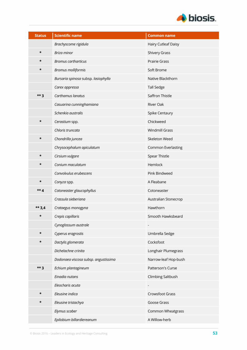
© Biosis 2016 – Leaders in Ecology and Heritage Consulting 53
Status Scientific name Common name
Brachyscome rigidula Hairy Cutleaf Daisy
* Briza minor Shivery Grass
* Bromus cartharticus Prairie Grass
* Bromus molliformis Soft Brome
Bursaria spinosa subsp. lasiophylla Native Blackthorn
Carex appressa Tall Sedge
** 3 Carthamus lanatus Saffron Thistle
Casuarina cunninghamiana River Oak
Schenkia australis Spike Centaury
* Cerastium spp. Chickweed
Chloris truncata Windmill Grass
* Chondrilla juncea Skeleton Weed
Chrysocephalum apiculatum Common Everlasting
* Cirsium vulgare Spear Thistle
* Conium maculatum Hemlock
Convolvulus erubescens Pink Bindweed
* Conyza spp. A Fleabane
** 4 Cotoneaster glaucophyllus Cotoneaster
Crassula sieberiana Australian Stonecrop
** 3,4 Crataegus monogyna Hawthorn
* Crepis capillaris Smooth Hawksbeard
Cynoglossum australe -
* Cyperus eragrostis Umbrella Sedge
* Dactylis glomerata Cocksfoot
Dichelachne crinita Longhair Plumegrass
Dodonaea viscosa subsp. angustissima Narrow-leaf Hop-bush
** 3 Echium plantagineum Patterson's Curse
Einadia nutans Climbing Saltbush
Eleocharis acuta -
* Eleusine indica Crowsfoot Grass
* Eleusine tristachya Goose Grass
Elymus scaber Common Wheatgrass
Epilobium billardiereanum A Willow-herb

© Biosis 2016 – Leaders in Ecology and Heritage Consulting 54
Status Scientific name Common name
** 3 Eragrostis curvula African Lovegrass
Eragrostis leptostachya Paddock Lovegrass
Eryngium ovinum Blue Devil
Eucalyptus blakelyi Blakely's Red Gum
Eucalyptus bridgesiana Apple Box
Eucalyptus mannifera Brittle Gum
Eucalyptus melliodora Yellow Box
Eucalyptus pauciflora Snow Gum
Euchiton sphaericus Star Cudweed
* Festuca elatior Tall Fescue
Fimbristylis dichotoma Common Fringe-sedge
Geranium solanderi Native Geranium
Glycine clandestina Twining glycine
Glycine tabacina Variable Glycine
* Gnaphalium americanum -
Gonocarpus tetragynus Poverty Raspwort
Hardenbergia violacea False Sarsaparilla
* Hirschfeldia incana Buchan Weed
* Holcus lanatus Yorkshire Fog
* Hordeum leporinum Barley Grass
Hydrocotyle laxiflora Stinking Pennywort
Hypericum gramineum Small St John's Wort
** 3 Hypericum perforatum St. Johns Wort
* Hypochaeris glabra Smooth Catsear
* Hypochaeris radicata Catsear
Juncus australis Rush
Lachnagrostis aemula Blowngrass
* Lactuca serriola Prickly Lettuce
* Lepidium spp. A Peppercress
Leptospermum continentale Prickly Teatree
* Lolium perenne Perennial Ryegrass
Lomandra bracteata Mat-rush
Lomandra filiformis Wattle Matt-rush

© Biosis 2016 – Leaders in Ecology and Heritage Consulting 55
Status Scientific name Common name
Lomandra longifolia Spiny-headed Mat-rush
Lomandra multiflora Many-flowered Mat-rush
** 2,4 Lycium ferocissimum African Boxthorn
* Malva spp. Mallow
* Marrubium vulgare White Horehound
Microlaena stipoides Weeping Grass
* Modiola caroliniana Red-flowered Mallow
** 3,4 Nassella neesiana Chilean Needle Grass
* Nasturtium microphyllum Nasturtium
* Nothoscordum gracile Onion Weed
** 3 Onopordum acanthium subsp. acanthium Scotch Thistle
* Oxalis corniculata Creeping Oxalis
Oxalis perennans Oxalis
Panicum effusum Hairy Panic
* Paspalum dilatatum Paspalum
* Petrorhagia nanteuilii Proliferous Pink
* Phalaris aquatica Phalaris
Phragmites australis Common Reed
Pimelea curviflora var. sericea Rice Flower
** 3 Pinus radiata Radiata Pine
Plantago lanceolata Lamb's Tongues
* Plantago major Large Plantain
Poa labillardierei Tussock grass
* Polycarpon tetraphyllum Four-leaved Allseed
* Polypogon monspeliensis Annual Beardgrass
* Populus nigra Lombardy Poplar
Portulaca oleracea Pigweed
Prasophyllum spp. Leek Orchid
* Prunus spp. Apricot
Pseuderanthemum variabile Pastel Flower
** 2,4 Rosa rubiginosa Sweet Briar
** 3,4 Rubus fruticosus sp. agg. Blackberry complex
Rubus parvifolius Native Raspberry

© Biosis 2016 – Leaders in Ecology and Heritage Consulting 56
Status Scientific name Common name
Rumex brownii Swamp Dock
* Rumex crispus Curled Dock
Rumex dumosus Wiry Dock
* Rumex obtusifolius Broadleaf Dock
Rytidosperma caespitosum Ringed Wallaby Grass
** 2,4 Salix fragilis Crack Willow
* Salix babylonica Weeping Willow
* Salvia verbenaca Vervain
Senecio quadridentatus Cotton Fireweed
* Sonchus oleraceus Common Sowthistle
Sorghum leiocladum Wild Sorghum
* Taraxacum officinale Dandelion
Themeda triandra Kangaroo Grass
* Tragopogon dubius Goatsbeard
* Trifolium campestre Hop Clover
* Trifolium arvense Haresfoot Clover
* Trifolium repens White Clover
Typha spp. Cumbungi
* Verbascum thapsus Blanket Weed
* Verbascum virgatum Twiggy Mullein
* Verbena bonariensis Purpletop
Vittadinia cuneata A Fuzzweed
* Vulpia myuros Rat's Tail Fescue
Wahlenbergia communis Tufted Bluebell
Wahlenbergia gracilis Sprawling Bluebell

© Biosis 2016 – Leaders in Ecology and Heritage Consulting 57
Appendix 2 Fauna
Fauna species in these tables are listed in alphabetical order within their taxonomic group.
A2.1 Fauna species recorded from the study area
Below is a list of fauna species detected via incidental observation within the study area during the present
assessment.
Notes to table:
EPBC Act:
EX - Extinct
CR - Critically Endangered
EN – Endangered
VU - Vulnerable
CD - Conservation dependent
M - Migratory
NC Act:
(i) – extinct
(ii) – extinct in the wild
(iii) – critically endangered
(iv) –endangered
(v) – vulnerable
(vi) – conservation dependent
(vii) - provisional
* - introduced species
Table A.2 Vertebrate fauna recorded from the study area (current assessment)
Status Scientific name Common name
Birds
Accipiter fasciatus Brown Goshawk
Anthus novaeseelandiae Australasian Pipit
Corvus bennetti Little Raven
Cacatua galerita Sulphur-crested Cockatoo
Cracticus nigrogularis Pied Butcherbird
Cracticus tibicen Australian Magpie
Dacelo novaeguineae Laughing Kookaburra
Eolophus roseicapilla Galah
Grallina cyanolaeuca Magpie Lark
M Merops ornatus Rainbow Bee-eater
Platycercus eximius Eastern Rosella
Rhipidura albiscapa Grey Fantail
Rhipidura leucophrys Willie Wagtail
Mammals

© Biosis 2016 – Leaders in Ecology and Heritage Consulting 58
Status Scientific name Common name
* Bos Taurus Cattle
* Equus caballus Horse
* Lepus capensis Brown Hare
Macropus giganteus Eastern Grey Kangaroo
* ## Oryctolagus cuniculus European Rabbit
* Ovis aries Sheep
* ## Vulpes vulpes Fox
Wallabia bicolor Swamp Wallaby
Reptiles
Pseudonaja textilis Eastern Brown Snake
## established pest species as defined under the ACT Pest Plants and Animals Act (ACT Government 2005b).

© Biosis 2016 – Leaders in Ecology and Heritage Consulting 59
Appendix 3 Figure 4. Detailed Map of Ecological Values

Mccu
lloch
Stree
t
Lady Denman Drive
Lady Denman Drive
Yarra
Glen
Parkes Way
Caswell Drive
Tuggeranong Par
kway
Cotter Road
Copp
insCro
ssing
Road
Coult
erDr
ive
Pescott Lane
Ram
Road
See Pl
ace
BenthamStreet
Dun stan Street
Bindubi Street
Uriarra Road
Dunrossil Drive
Barr e njoey
Dri
ve
The Bicentennial National Trail
The Bice ntennial National Trail
HoldensCreek
DeepCreek
MolongloRiver
WestonCreek
CoppinsCreek
Yar ralumla Creek
ACACIA INLET
WARRINA INLET
NURSERY BAY
YARRAMUNDIREACH
© Land and Property Information 2015
0 220 440 660 880 1,100
Metres
LegendStudy areaFUA boundary
Fauna habitatBlack CockatooLittle Eagle
#* #* #* #*
#* #* #* #*Superb Parrot and Swift ParrotPink-tailed Worm-lizard - High (by vegetation community) Pink-tailed Worm-lizard - Moderate (by vegetation community)Pink-tailed Worm-lizard - Poor (by vegetation community)Pink-tailed Worm-lizard (Osbourne 2010, Biosis corrected)
±
Matter: 21593Date: 26 February 2016, Checked by: NRT, Drawn by: LH, Last edited by: lharleyLocation:P:\21500s\21593\Mapping\21593_F4_FaunaHabitatOverview
Biosis Pty LtdBallarat, Brisbane, Canberra, Melbourne,
Newcastle, Sydney, Wangaratta & Wollongong
Scale: 1:22,000 @ A3
Figure 4: Fauna habitat -overview
Coordinate System: GDA 1994 MGA Zone 55
Acknowledgements: Imagery (c) LPI 2014; Basemap © Land and Property Information 2015

© Biosis 2016 – Leaders in Ecology and Heritage Consulting 60
Appendix 4 Figure 5. Detailed Map of Fauna Habitat Values

William Hovell Drive
Molonglo River
Deep Creek
© Land and Property Information 2015
0 50 100 150 200 250
Metres
LegendStudy areaFUA boundary
Fauna habitatBlack CockatooLittle Eagle
#* #*
#* #*Superb Parrot and Swift ParrotPink-tailed Worm-lizard - High (by vegetation community) Pink-tailed Worm-lizard - Moderate (by vegetation community)Pink-tailed Worm-lizard - Poor (by vegetation community)Pink-tailed Worm-lizard (Osbourne 2010, Biosis corrected)
±
Matter: 21593Date: 26 February 2016, Checked by: NRT, Drawn by: LH, Last edited by: lharleyLocation:P:\21500s\21593\Mapping\21593_F5_FaunaHabitat_Detail
Biosis Pty LtdBallarat, Brisbane, Canberra, Melbourne,
Newcastle, Sydney, Wangaratta & Wollongong
5.7
5.5 5.6
5.9
5.4
5.8
5.1 5.2 5.3
5.10
Scale: 1:5,500 @ A3
Figure 5.1: Fauna habitat -detail
Coordinate System: GDA 1994 MGA Zone 55
Acknowledgements: Imagery (c) LPI 2014; Basemap © Land and Property Information 2015

Coult
er Dri
ve
William Hovell Drive Coult
erDr
ive
Deep Creek
© Land and Property Information 2015
0 50 100 150 200 250
Metres
LegendStudy areaFUA boundary
Fauna habitatBlack CockatooLittle Eagle
#* #*
#* #*Superb Parrot and Swift ParrotPink-tailed Worm-lizard - High (by vegetation community) Pink-tailed Worm-lizard - Moderate (by vegetation community)Pink-tailed Worm-lizard - Poor (by vegetation community)Pink-tailed Worm-lizard (Osbourne 2010, Biosis corrected)
±
Matter: 21593Date: 26 February 2016, Checked by: NRT, Drawn by: LH, Last edited by: lharleyLocation:P:\21500s\21593\Mapping\21593_F5_FaunaHabitat_Detail
Biosis Pty LtdBallarat, Brisbane, Canberra, Melbourne,
Newcastle, Sydney, Wangaratta & Wollongong
5.7
5.5 5.6
5.9
5.4
5.8
5.1 5.2 5.3
5.10
Scale: 1:5,500 @ A3
Figure 5.2: Fauna habitat -detail
Coordinate System: GDA 1994 MGA Zone 55
Acknowledgements: Imagery (c) LPI 2014; Basemap © Land and Property Information 2015

William Hovell DriveBin
d ubi
St re e
t
Bindubi Street Bindubi Street
Bindubi Street
Bindu
bi Str
eet
Mackellar Crescent
Dwyer Street
Booth Crescent
The Bicentennial National Trail
The BicentennialNa tional Trail
© Land and Property Information 2015
0 50 100 150 200 250
Metres
LegendStudy areaFUA boundary
Fauna habitatBlack CockatooLittle Eagle
#* #*
#* #*Superb Parrot and Swift ParrotPink-tailed Worm-lizard - High (by vegetation community) Pink-tailed Worm-lizard - Moderate (by vegetation community)Pink-tailed Worm-lizard - Poor (by vegetation community)Pink-tailed Worm-lizard (Osbourne 2010, Biosis corrected)
±
Ma tter: 21593Da te : 26 F eb ru a ry 2016, Ch ecked by: N R T, D raw n by: L H , La st ed ited by: lh ar leyLocation :P:\21500s\21593\M a pp in g\21593_F5 _Fa un aH ab ita t_D eta il
Biosis Pty LtdBallarat, Brisbane, Canberra, Melbourne,
Newcastle, Sydney, Wangaratta & Wollongong
5.7
5.5 5.6
5.9
5.4
5.8
5.1 5.2 5.3
5.10
Scale: 1:5,500 @ A3
Figure 5.3: Fauna habitat -detail
Coordinate System: GDA 1994 MGA Zone 55
Acknowledgements: Imagery (c) LPI 2014; Basemap © Land and Property Information 2015

Coppin
s Cros
singR
oad
CoppinsCreek
DeepCreek
Molonglo River
Molonglo River
© Land and Property Information 2015
0 50 100 150 200 250
Metres
LegendStudy areaFUA boundary
Fauna habitatBlack CockatooLittle Eagle
#* #*
#* #*Superb Parrot and Swift ParrotPink-tailed Worm-lizard - High (by vegetation community) Pink-tailed Worm-lizard - Moderate (by vegetation community)Pink-tailed Worm-lizard - Poor (by vegetation community)Pink-tailed Worm-lizard (Osbourne 2010, Biosis corrected)
±
Matter: 21593Date: 26 February 2016, Checked by: NRT, Drawn by: LH, Last edited by: lharleyLocation:P:\21500s\21593\Mapping\21593_F5_FaunaHabitat_Detail
Biosis Pty LtdBallarat, Brisbane, Canberra, Melbourne,
Newcastle, Sydney, Wangaratta & Wollongong
5.7
5.5 5.6
5.9
5.4
5.8
5.1 5.2 5.3
5.10
Scale: 1:5,500 @ A3
Figure 5.4: Fauna habitat -detail
Coordinate System: GDA 1994 MGA Zone 55
Acknowledgements: Imagery (c) LPI 2014; Basemap © Land and Property Information 2015

Coppins Creek
© Land and Property Information 2015
0 50 100 150 200 250
Metres
LegendStudy areaFUA boundary
Fauna habitatBlack CockatooLittle Eagle
#* #*
#* #*Superb Parrot and Swift ParrotPink-tailed Worm-lizard - High (by vegetation community) Pink-tailed Worm-lizard - Moderate (by vegetation community)Pink-tailed Worm-lizard - Poor (by vegetation community)Pink-tailed Worm-lizard (Osbourne 2010, Biosis corrected)
±
Matter: 21593Date: 26 February 2016, Checked by: NRT, Drawn by: LH, Last edited by: lharleyLocation:P:\21500s\21593\Mapping\21593_F5_FaunaHabitat_Detail
Biosis Pty LtdBallarat, Brisbane, Canberra, Melbourne,
Newcastle, Sydney, Wangaratta & Wollongong
5.7
5.5 5.6
5.9
5.4
5.8
5.1 5.2 5.3
5.10
Scale: 1:5,500 @ A3
Figure 5.5: Fauna habitat -detail
Coordinate System: GDA 1994 MGA Zone 55
Acknowledgements: Imagery (c) LPI 2014; Basemap © Land and Property Information 2015

Tuggeranong Parkway
Parkes Way
William Hove
ll Drive
Lady Denman Drive
The Bicentennial National Trail
© Land and Property Information 2015
0 50 100 150 200 250
Metres
LegendStudy areaFUA boundary
Fauna habitatBlack CockatooLittle Eagle
#* #*
#* #*Superb Parrot and Swift ParrotPink-tailed Worm-lizard - High (by vegetation community) Pink-tailed Worm-lizard - Moderate (by vegetation community)Pink-tailed Worm-lizard - Poor (by vegetation community)Pink-tailed Worm-lizard (Osbourne 2010, Biosis corrected)
±
Ma tter: 21593Da te : 26 F eb ru a ry 2016, Ch ecked by: N R T, D raw n by: L H , La st ed ited by: lh ar leyLocation :P:\21500s\21593\M a pp in g\21593_F5 _Fa un aH ab ita t_D eta il
Biosis Pty LtdBallarat, Brisbane, Canberra, Melbourne,
Newcastle, Sydney, Wangaratta & Wollongong
5.7
5.5 5.6
5.9
5.4
5.8
5.1 5.2 5.3
5.10
Scale: 1:5,500 @ A3
Figure 5.6: Fauna habitat -detail
Coordinate System: GDA 1994 MGA Zone 55
Acknowledgements: Imagery (c) LPI 2014; Basemap © Land and Property Information 2015

Copp
insCro
ssing
Road
Molonglo River
© Land and Property Information 2015
0 50 100 150 200 250
Metres
LegendStudy areaFUA boundary
Fauna habitatBlack CockatooLittle Eagle
#* #*
#* #*Superb Parrot and Swift ParrotPink-tailed Worm-lizard - High (by vegetation community) Pink-tailed Worm-lizard - Moderate (by vegetation community)Pink-tailed Worm-lizard - Poor (by vegetation community)Pink-tailed Worm-lizard (Osbourne 2010, Biosis corrected)
±
Matter: 21593Date: 26 February 2016, Checked by: NRT, Drawn by: LH, Last edited by: lharleyLocation:P:\21500s\21593\Mapping\21593_F5_FaunaHabitat_Detail
Biosis Pty LtdBallarat, Brisbane, Canberra, Melbourne,
Newcastle, Sydney, Wangaratta & Wollongong
5.7
5.5 5.6
5.9
5.4
5.8
5.1 5.2 5.3
5.10
Scale: 1:5,500 @ A3
Figure 5.7: Fauna habitat -detail
Coordinate System: GDA 1994 MGA Zone 55
Acknowledgements: Imagery (c) LPI 2014; Basemap © Land and Property Information 2015

Tugger
anon
g Parkw
ay Lady Denman Drive
Lady D
enman
Drive
Dunross
il Drive
The B
i cente
nnial
Nat i o
nal T
ra il
The Bicentennial National Trail
MolongloRiver
Yarralumla Creek
© Land and Property Information 2015
0 50 100 150 200 250
Metres
LegendStudy areaFUA boundary
Fauna habitatBlack CockatooLittle Eagle
#* #*
#* #*Superb Parrot and Swift ParrotPink-tailed Worm-lizard - High (by vegetation community) Pink-tailed Worm-lizard - Moderate (by vegetation community)Pink-tailed Worm-lizard - Poor (by vegetation community)Pink-tailed Worm-lizard (Osbourne 2010, Biosis corrected)
±
Matter: 21593Date: 26 February 2016, Checked by: NRT, Drawn by: LH, Last edited by: lharleyLocation:P:\21500s\21593\Mapping\21593_F5_FaunaHabitat_Detail
Biosis Pty LtdBallarat, Brisbane, Canberra, Melbourne,
Newcastle, Sydney, Wangaratta & Wollongong
5.7
5.5 5.6
5.9
5.4
5.8
5.1 5.2 5.3
5.10
Scale: 1:5,500 @ A3
Figure 5.8: Fauna habitat -detail
Coordinate System: GDA 1994 MGA Zone 55
Acknowledgements: Imagery (c) LPI 2014; Basemap © Land and Property Information 2015

Uri arraRoad
The Bicentennial National Trail
The Bicentennial National Trail
Ho ldensCreek
Westo
n Creek
Molonglo River
© Land and Property Information 2015
0 50 100 150 200 250
Metres
LegendStudy areaFUA boundary
Fauna habitatBlack CockatooLittle Eagle
#* #*
#* #*Superb Parrot and Swift ParrotPink-tailed Worm-lizard - High (by vegetation community) Pink-tailed Worm-lizard - Moderate (by vegetation community)Pink-tailed Worm-lizard - Poor (by vegetation community)Pink-tailed Worm-lizard (Osbourne 2010, Biosis corrected)
±
Matter: 21593Date: 26 February 2016, Checked by: NRT, Drawn by: LH, Last edited by: lharleyLocation:P:\21500s\21593\Mapping\21593_F5_FaunaHabitat_Detail
Biosis Pty LtdBallarat, Brisbane, Canberra, Melbourne,
Newcastle, Sydney, Wangaratta & Wollongong
5.7
5.5 5.6
5.9
5.4
5.8
5.1 5.2 5.3
5.10
Scale: 1:5,500 @ A3
Figure 5.9: Fauna habitat -detail
Coordinate System: GDA 1994 MGA Zone 55
Acknowledgements: Imagery (c) LPI 2014; Basemap © Land and Property Information 2015

Tuggeranong Parkway Cotter Road
ByrnesPlace
Morehead StreetKirkpatrick Street
Dunst
an Street
The Bicentennial National Trail
The Bicentennial National Trail
Weston
Creek
Molonglo River
© Land and Property Information 2015
0 50 100 150 200 250
Metres
LegendStudy areaFUA boundary
Fauna habitatBlack CockatooLittle Eagle
#* #*
#* #*Superb Parrot and Swift ParrotPink-tailed Worm-lizard - High (by vegetation community) Pink-tailed Worm-lizard - Moderate (by vegetation community)Pink-tailed Worm-lizard - Poor (by vegetation community)Pink-tailed Worm-lizard (Osbourne 2010, Biosis corrected)
±
Matter: 21593Date: 26 February 2016, Checked by: NRT, Drawn by: LH, Last edited by: lharleyLocation:P:\21500s\21593\Mapping\21593_F5_FaunaHabitat_Detail
Biosis Pty LtdBallarat, Brisbane, Canberra, Melbourne,
Newcastle, Sydney, Wangaratta & Wollongong
5.7
5.5 5.6
5.9
5.4
5.8
5.1 5.2 5.3
5.10
Scale: 1:5,500 @ A3
Figure 5.10: Fauna habitat -detail
Coordinate System: GDA 1994 MGA Zone 55
Acknowledgements: Imagery (c) LPI 2014; Basemap © Land and Property Information 2015