monitoring grassland birds at pyramid state park, … grassland birds at pyramid state park, perry...
TRANSCRIPT
Monitoring Grassland Birds at Pyramid State Park, PerryCounty, Illinois
Duration of Research: 1 January to 30 July 2003
Location of Research: Pyramid State Park grassland complex, Perry County, Illinois
Annual Report to IDNR
RECEfVEBy:
DEC", 5 2003
Jeffrey P. Hoover
FEDERAL AIDIllinois Natural History Survey
607 E. Peabody Drive, Champaign, IL 61820ph: (352) 392-1721 ext. 511 ; e-mail: [email protected]

i
,: INTRODUCTION
A primary goal of Conservation Biology is to gain an understanding of how human-
induced alterations of the landscape influence the residual biotic communities (Soule 1986,
Wiens 1996). Related goals include the documentation of these influences with appropriate
research and the subsequent prioritization of conservation efforts aimed at reducing or
ameliorating any negative effects . Loss of habitat is often thought of as the primary factor
contributing to wildlife population declines and may be the greatest threat to present day wildlife
populations at both global and local scales (Wilcove et al . 1998, Illinois Wildlife Habitat
Commission 1985). A related form of landscape alteration, habitat fragmentation, has also
become a leading conservation issue (Wilcove et al. 1998) and a vast amount of research has
been directed at determining both local and regional effects of fragmentation on populations of
organisms in the remnant habitat patches .Y
The fragmentation of habitat results in a reduction and patchiness of habitat and isolation
of remnant habitat patches from each other. The resulting landscape, particularly the land-use
surrounding the remaining habitat, can have a profound influence on those organisms remaining
in remnant patches . The landscape in the Midwest region of the United States comprises small
fragments of native habitat embedded within a matrix of land use that is predominated by
agriculture and urban development . Some habitats have been especially hard hit . For example,
native grasslands east of the Mississippi River have been reduced by over 90%, with estimates of
regional reductions often exceeding 99% (Noss et al. 1995). In Illinois, there is less than 1% of
the original native prairie/grassland habitat remaining (Schwegman 1983), and that habitat that
remains is typically in small (<50 acres) isolated patches .
The loss and fragmentation of grassland/prairie habitat has been blamed, in part, for the
long-term population declines of several species of grassland-dependent birds (Askins 2000) .
Results from Breeding Bird Survey routes located east of the Mississippi River indicate that
since 1966, the abundance of an overwhelming majority of species of grassland and savanna
birds in eastern North America has fallen (Askins 1993, Sauer et al . 2001). Some examples of
those species suffering the largest decreases in abundance include the Henslow's Sparrow
(scientific names given in Tables 2 and 3), Grasshopper Sparrow, Eastern Meadowlark, Short-
eared Owl and Dickcissel . These declines have been attributed to a combination of habitat loss
(of native and non-native grassland) (Herkert 1991 a, Warner 1994), as well as factors associated
with habitat fragmentation (e .g., increased rates of nest predation and brood parasitism, area
sensitivity) . When grasslands are fragmented by non-grassland land use (e.g., row-crop
agriculture, urban development), the remaining tracts of grassland habitat may be too small and
some species of bird may become absent or less abundant ("area sensitivity" ; Herkert 1994a, b ;
Vickery 1994) . These fragmented grasslands may further act as "ecological traps" for those
songbirds that still attempt to breed there because they may harbor large populations of nest
predators (Hoffman and Heske 2003) and brood parasitic cowbirds (Johnson and Temple 1990) .
Nesting success of many species of grassland bird may be so low in fragmented landscapes that
it is unlikely that their populations could be self-sustaining . An additional difficulty facing
grassland birds is that many species are habitat specialists having preferences for a particular
vegetation height and/or density (Skinner et al . 1984, Herkert 1991b, Scott et al . 2002). These
preferences necessitate management of vast areas of grassland : habitat as a mosaic of patches of
grassland in different stages of recovery from disturbance in order to support the greatest
diversity of grassland species .
Despite the loss of over 99% of the native grassland habitat in Illinois, there are currently
2 programs that result in the creation of grassland habitat . These are the Conservation Reserve
Program (CRP) and surface coal mine reclamation . CRP has converted much cropland to
grassland habitat (Best et al . 1997), but the program is federally sponsored and affected by
politics, with no guarantee that the grassland that is created under the auspices of CRP will
remain as grassland habitat in perpetuity . Surface coal mine reclamation is less well-known, but
has produced thousands of hectares of grassland' habitat in portions of Illinois, Indiana, and
Kentucky (Brothers 1990, Scott et al . 2002). Recently, studies in Indiana have demonstrated the
potential importance of grassland habitats associated with reclaimed surface coal mines for
grassland-dependent birds (Bajema et al . 2001, DeVault et al . 2002). The recent acquisition of a
reclaimed mine by the Illinois Department of Natural Resources is also an example of a large site
with the potential to benefit grassland-dependent birds and wildlife .
The Ark Land complex in Per y County, Illinois consists of approximately 17,000 acres
of mined lands that are in the process of being restored to a matrix of grasslands, shrublands,
wetlands, lakes, ponds, pastures, and agricultural fields . The Illinois Department of Natural
Resources (IDNR) acquisition of the Ark Land complex was completed in 2001, and the land
was added to Pyramid State Park (PSP) creating the largest IDNR site in the state . The Pyramid
State Park grassland complex (hereafter referred to as PSP) contains several thousand acres of
grassland habitat, making it one of the largest areas of grassland habitat in the state of Illinois .
The potential for grassland wildlife on this site is tremendous but only limited information on the
species currently using the site is available . Numerous avian species of special concern,
including several state listed species, may occur at the site . Surveys of the bird community on
the site would document avian use of the PSP complex and identify areas on the site that contain

I
f,
species of special concern. IDNR personnel could use the information obtained during these'
surveys to assist with the continued development and implementation of the management plan
for, the complex . In addition, as different management practices are applied to the grasslands at
PSP (e.g., prescribed burning, grazing, removal of autumn olive, etc .), the response of the bird
community to the management could be documented . This would provide vital information for
the managers at the site, would be one measure of the success of the grassland restoration effort,
and the results would be applicable to other sites throughout the state that are being managed as
grassland ecosystems. In addition, information on the bird community present prior to the
completion and implementation of a management plan for the site provides the unique
opportunity to document the response of the bird community to the management occurring on the
site . .
The specific objectives of this research were :
(1) To conduct a second year of avian surveys at the Pyramid State Park grassland
complex, Perry County, Illinois to document all species utilizing the site during the
breeding season and winter .
(2) Identify any state listed species and the habitats that they are using, and document
any unusually high concentrations of grassland birds present within the complex .
(3) Submit all sightings and confirmed breeding by state listed species at PSP to the
Natural Heritage Database .
(4) Complete a report summarizing the presence, abundance and distribution of birds in
the PSP grassland complex .
The bird community in the Ark Land complex was surveyed during the breeding season
(late April-July 2003) and during the winter (January-March 2003) . With the assistance of a
field technician, I conducted five-minute point counts (Bibby et al . 1992) throughout the
grassland complex at PSP. An extensive network of roads (paved and unpaved) is distributed
throughout the grassland complex providing access to most areas within the three primary units
of the park (Captain, Denmark, and Galum ; see Figs. 1-3) . In 20021 established 153 points
along these roads, distributing the points at >300m intervals (point locations given in Figs . 1-3) .
In 2003, I resampled each of the 153 roadside points and my assistant added another 133 points
off-road (locations of points given on Figs. 1-3). Point counts were confined to a 6-hour period
beginning at sunrise on days with little wind and no rain . We stopped at each census point for 5
minutes and recorded all of the birds present within 100m . For each bird detected, we recorded
species, mode of detection (song, call, or visual), and the direction and estimated distance of the
individual from the center of the census point . Each 100-m radius census point represents
approximately 3.14 hectares of area and results from the point count surveys are given as the
number of individuals per hectare for each species (Tables 2-3) . Data from point counts provide
estimates of densities for each species and are the most useful data for documenting changes in
abundance over time (as points are revisited in subsequent years) . The percentage occurrence
(number of census points a species was detected at/total number of census points) was
determined for each species (roadside counts only) as an index of how widespread each species
was over the entire site . A GPS unit (GARMIN GPS V) was used to document the location of
each census point within the complex, so that points can be easily located and surveyed in the
future. A qualitative description of the habitat at each roadside census point was recorded (with
6
assistance from T . Esker) in 2002 and these descriptions are given in Table 1 . These descriptions
should be updated as the management plan for the site is implemented or as any changes in land
,use or plant succession occur .
. The results of the roadside and off-road censuses provide additional baseline information
for comparisons with data collected in a similar fashion in the future to look for relative
(qualitative) changes in numbers for each species . Most birds counted during the breeding
season were singing, and therefore adult males. However, detections by sight or call note likely
included some females, especially for conspicuous species such as the Red-winged Blackbird
and the Eastern Meadowlark, so I report count data as "individuals" per hectare .
I tested whether the relative densities of all species recorded at roadside points were
correlated with relative abundances off-road . For each species, the density given in Table 2 for
2003 was compared to the density given in Table 3 . A highly significant correlation between thea
values would indicate that the roadside point counts accurately characterize density relationships
among the breeding bird assemblage of this habitat (DeVault et al . 2002) .
During the winter (January-March of 2003), surveys were conducted similar to Christmas
Bird Counts. One other observer and myself surveyed the birds at the PSP grassland complex by
driving roads and walking through some sections . We recorded all birds detected (via .
observation or vocalization) on each of 6 visits (with a special emphasis on raptors, waterfowl,
and waterbirds) as well as the number of hours spent surveying the site . The numbers of
individuals seen over the course of all visits were documented for each species . As with the
breeding season surveys, these values provide a baseline of information and allow for
comparisons with data collected in a similar manner in the future .
7
Locations (date, township, range, and section) of all birds classified as endangered or
threatened in Illinois were documented . This information will be submitted to the Endangered
Species Protection Board in Illinois, and is also summarized in Table 5 in this report .
RESULTS
Habitat . The habitat was described at the 153 roadside census points distributed
n
throughout the PSP grassland complex (Table 1). The points listed in Table I correspond to
census points shown in Figures 1-3 . The habitat structure and composition was diverse . In a
general sense, the prevailing habitat on the site falls into two categories : grassland and
successional scrub. Grassland habitat typically included one or more of the following plant
species as a dominant component : fescue; brome; broom sedge ; annual weeds including boneset,
goldenrod, cheatgrass, sunflower, and foxtail ; tall grass prairie including big blue stem and
Indian grass ; and areas of pasture . Tree plantings and autumn olive thickets represent the major
forms of woody encroachment that constitute the successional scrub habitat . If left unmanaged,
the woody encroachment would likely overrun the site and lead to the conversion of the
grasslands to a scrub-shrub and eventually forested complex over time . Areas of row-crop
agriculture were scattered throughout the site including corn, wheat, soybeans, and no-till
soybeans. Hundreds of acres of open water exist on the site, with much of it surrounded by
narrow bands of phragmites .
8
I
Breeding Season. A diverse assemblage of birds was again recorded in 2003 on the PSP
grassland complex during the breeding season . In total (roadside and off-road counts), 81
species were documented on the site (Tables 2 and 3) . The densities of species on roadside point
counts (individuals/hectare in 2003 ; Table 2) and off-road trahsects (individuals/hectare ; Table
3) were highly positively correlated (r-0 .933, N=81 species, P<0.0001). This indicates that the
roadside point counts accurately portrayed the breeding bird community throughout the entire
complex, especially for those species that are common. Results from the 2003 bird survey were
similar to those from 2002 in terms of relative densities of particular species and their
distributions throughout the site (Table 2). Red-winged Blackbirds were again the most
abundant species on the site, and were also the most widely distributed (Table 2). An additional
six species were also present throughout much of the site (i.e ., >40% occurrence) including
American Goldfinch, Eastern Meadowlark, Indigo Bunting, Dickcissel, Northern Bobwhite, and
Mourning Dove. Twenty-four species were uncommon or very narrowly distributed and were
recorded at <5% of the census points (Table 2) . Most of these species were uncommon because
they are typically associated with a non-grassland/shrubland habitat feature (e .g ., human
structures for Barn Swallows and Eastern Phoebes, a stream for Belted Kingfishers, woody fence
rows or forest for woodpeckers, etc). Game birds that were abundant on the site included the
Northern Bobwhite and Mourning Dove (Table 2) . In general, the two prominent bird
communities that exist on the site are grassland and successional scrub, mirroring the prevailing
habitat types .
Grassland Birds . Several grassland specialists or grassland-associated species were
common on the site (Tables 2 and 3) . This includes substantial numbers for some of the species
that have undergone significant population decreases throughout the eastern United States in
recent decades including the Eastern Meadowlark, Dickcissel, Northern Bobwhite, and
Grasshopper and Henslow's Sparrows. Because the roadside census points were systematically
placed throughout the site, they are a fairly unbiased sample and are representative of the birds
9
and habitats that currently, exist on the site . Numbers from the point counts can therefore be
extrapolated to roughly estimate the number of breeding pairs present on the entire site for each
species . Using the data from Table 2 for 2003 and an estimate of 6,000 ha for the area of the ,
complex yields the following estimates for the number of breeding pairs present : Eastern
Meadowlark=2,900; Dickcissel=2,300 ; Grasshopper Sparrow=950, Henslow's Sparrow--400.
These estimates represent substantial populations for these particular species with the potential to
enhance the populations by enacting a management plan that reduces the woody encroachment
of tree plantings and the invasive autumn olive and that also favors the restoration and
maintenance of a variety of grassland habitats .
Successional Scrub Birds . Nineteen species of bird that are associated with successional
scrub habitat (listed as "SS" in Table 2) were detected by the point counts . Several of these
species were quite common (e .g., Northern Bobwhite, Common Yellowthroat, Brown Thrasher,
Bell's Vireo, Willow Flycatcher, Yellow-breasted Chat) owing to the vast amounts of woody
vegetation present on the site in the form of tree plantings and shrubby growth (much of which is
the invasive autumn olive) . The Loggerhead Shrike was the only state-listed threatened species
present at low densities in open (grassland) areas that had a small component of shrubs . The
Bell's Vireo, a Watch List species, was abundant in the many shrubby thickets scattered
throughout the complex .
Winter. The site provides over-wintering habitat for a variety of species. Sixty-three
species of bird were found on the site during the winter (Table 4) . Large numbers of Northern
Harriers and Short-eared Owls were found throughout the site for the duration of the winter .
Nearly all of these individuals likely are migrants that pack into the site and utilize the grassland
10
habitat during the winter . The wetlands and lakes on the site provided habitat for a variety of
waterfowl (16 species of goose and duck) and waterbirds (e .g., Great Blue Heron and Pied-billed
Grebe; Table 4) .
State of Illinois' Endangered and Threatened Birds . The dates and locations for
observations of Illinois' Endangered and Threatened birds are given in Table 5. Twelve species
were documented on the site during the year (winter and summer) . Pied-billed Grebes were
especially common during the winter but were also sighted during their breeding season in two
different locations . A Double-crested Cormorant was seen on 2 dates in July near wetlands in
sections 2 and 10 of the "Captain" unit . American Bitterns were seen in May and June in two
different sections of the site and it is likely that they are breeding on the site . A Least Bittern
was observed in a wetland along Cutler Road in section 17 of the "Captain" Unit, and a group of
6 Little Blue Herons was observed foraging in a wetland west of Super Lake in section 11 of the
"Captain" Unit. Northern Harriers were incredibly abundant during the winter and in February
there was a one-day count of 64. There was also at least one pair of Northern Harriers present
during the breeding season . Bald Eagles were seen at Super Lake during the winter as well as
some individual sightings in April and May. An Osprey was observed near the Bald Eagle nest
in the "Galum" unit . Upland Sandpipers were seen in two different sections during their
breeding season and were associated with lightly grazed pastures . Short-eared Owls were
abundant during the winter, but none were seen after March . Loggerhead Shrikes were present
during the winter and breeding season with individuals or pairs being seen in eight different
sections during the breeding season . The shrikes were typically seen perched on old power lines
or on shrubs in grassland habitat that included a small component of shrubs . Henslow's
I1
Sparrows had the largest breeding population of all of the Illinois' E&T species present on the
site with at least 59 individuals observed during the breeding season . The Henslow's Sparrows
were associated with undisturbed grassland that usually contained a mixture of brome, fescue,
. ; swiich grass, broom sedge, red top, and other prairie plants.
DISCUSSION AND MANAGEMENT CONSIDERATIONS
The Pyramid State Park grassland complex presently supports large populations of
several breeding bird species typical of the grassland, successional scrub, and wetland habitat
present on the site . The birds present on the site during the breeding season include game and
nongame species, as well as species of special concern. A breeding bird survey of grasslands in
19 reclaimed coal mines in Indiana yielded results similar to the surveys at the PSP grassland
complex (DeVault et al. 2002). The reclaimed mine sites in Indiana also supported large
populations of four grassland specialists including Eastern Meadowlarks, Dickcissels,
Grasshopper Sparrows, and Henslow's Sparrows . These four species are among the top priority
migratory, grassland species of conservation concern in . the Midwest, with Henslow' Sparrows at
the top of the list (Herkert et al . 1996). All four of these species have shown significant declines
since 1966 based on Breeding Bird Survey data (Sauer et al . 2001) . The abundance of grassland
birds at PSP and other reclaimed mines in the region, along with the large size of these
grasslands (thousands of hectares), suggest that these reclaimed coal mines provide important
habitat for grassland birds (Bajema et al . 2001, DeVault et a1 .2002) .
Some of the advantages of managing grasslands on midwestern reclaimed mine sites
listed by Devault et al . (2002) include : the large size and minimal development of these sites, the
ease of managing for grassland habitat once it is established, the relative resistance to woody
12 .
13
plant succession, ownership by single entities, and the relative scarcity of Brown-headed
Cowbirds. Similar to what was found on reclaimed mine grasslands in Indiana (DeVault et
a1.2002), in 2002 cowbirds were uncommon at the PSP grassland complex and we would have
predicted that brood parasitism by cowbirds would be rare on a site as large as PSP (Johnson and
Temple 1990). During 2003, however, cowbirds were much more numerous (Tables 2 and 3) . It
is possible that the cowbirds were using the cattle pastures on the site as foraging habitat, and
may have been parasitizing nests off-site . It is uncertain to what extent the cowbirds
subsequently parasitized the available hosts on the site . Studies of the nesting success of
grassland birds at PSP would be necessary to document the severity of brood parasitism on the
site and to determine whether or not the cowbirds pose a threat .
Henslow's Sparrows were abundant in many areas of the grassland complex but their
territories tended to be clustered only in those areas with tall, dense, grass-dominated vegetationY
containing a substantial litter layer . These results are similar to what has been found in
grasslands on reclaimed mine sites in Indiana (Bajema et al . 2001) who also suggested that it was
important to manage for a diversity of grasses rather than a monoculture . This preferred habitat
of the Henslow's Sparrow would disappear as a result of natural plant succession, and active
management will be necessary to provide breeding habitat for this species in the long term . The
grassland bird community on the site would also benefit from management practices that
promote a variety of grassland structure so that species such as Homed Larks and Upland .
Sandpipers, which prefer short grass and bare areas, would become more abundant on the site . It
is possible that haying leases and light grazing by cattle could be effective components of a
management plan promoting grassland birds on the site (Herkert et al . 1993, Walk and Warner
2000): The timing of haying operations and the amount of grazing should follow the
recommendations given in Herkert et al . (1993) .
The encroachment of woody vegetation (in the form of tree plantations and the invasive
autumn olive) is possibly the most substantial threat to the grassland habitat at PSP . Autumn
olive is encroaching into grassland areas and is the dominant shrub in much of the site . Tree
plantings also threaten the grassland habitat, and much of the site will revert to forest habitat is
left unchecked. The longer the woody encroachment is allowed to proceed the more difficult it
will be to remove it and to promote grassland habitat. There are several management options
that may be necessary to remove the woody vegetation from areas where grasslands will be
favored including mechanical removal, prescribed burning, and herbicide treatments . For
grassland habitat that is already established or that will be restored, prescribed burning, light
grazing, and haying are all useful tools for maintaining grassland habitat and for preventing
succession of grassland areas to scrub-shrub or forest habitat (Herkert et al . 1993) .
Nongame grassland birds are benefited from management strategies centered on
protecting or establishing large contiguous grassland blocks, providing structurally diverse
habitat, eliminating catastrophic mid-season grassland mowing, reducing edge, and eliminating
and controlling woody encroachment (Herkert et al . 1993) . Several management guidelines for
grassland areas have been presented elsewhere (Herkert et al . 1993, 1996), and below I briefly
highlight some of the most pertinent (i .e ., important) for managing grasslands at PSP . Some
important management guidelines for grassland habitat include :
1) Avoid fragmentation of existing grassland areas and manage in large blocks to
maximize the likelihood of providing adequate habitat for area-sensitive species .
14
recommended to mow on a rotational system as with grazing .
With much less of than 1 % of the state's original 21 million acres of prairie/grassland
habitat remaining, it is not surprising that populations of grassland wildlife (especially our
grassland birds) have also suffered substantial decreases in abundance . The acquisition and
subsequent management of the PSP 6,000 ha reclaimed mine site is a tremendous opportunity to
15
2) Grassland restorations should be large (thousands of acres are better than hundreds of
acres) to benefit grassland bird species with high sensitivity to habitat fragmentation,
to promote higher rates of nesting success (reduced brood parasitism by cowbirds and
nest predation), and to allow for a more diverse management scheme .
3) Minimize the amount of linear edge, make the grassland as blocky as possible
(circular or square plots are preferable).
4) Use mixtures of tall and short grasses for plantings to accommodate preferences of
different grassland bird species . Native warm season grasses are preferred .
Recommended tall grasses include big bluestem, Indian grass and switch grass .
Recommended short grasses include little bluestem, side oats grama and prairie
dropseed .
5) Conduct prescribed bums in a rotation of 20-30% of the area annually .
6) Remove and control woody vegetation that exceeds the normal grass height .
7) Light grazing that is properly controlled can be a valuable technique for managing
grassland areas for breeding birds . Keep grazing light and use a rotation system to
leave some areas idle while others are grazed .
8) If areas are to be hayed or mowed to control woody vegetation, avoid mowing prior
to late July or early August to avoid destroying bird nests . In addition, it is
16
provide important grassland habitat for grassland-dependent birds . The PSP grassland complex
is large enough that it would be possible to manage a substantial acreage (preferably >2000
acres) for nongame grassland birds, to provide habitat (e.g ., shrub-scrub and wetland) for other
wildlife resources elsewhere on the site, and to simultaneously provide the necessary recreational
opportunities for the many different user groups associated with state park lands .
As a management plan for the PSP grassland complex is developed and implemented,
and as different management practices are utilized, we now have 2 years of necessary baseline
data for the bird community on the site to allow us to document changes in the bird community
in relation to changes in land use and habitat management on the site . These data will prove
invaluable for documenting changes in the bird community as management on the site proceeds
and will further our understanding of how to manage grasslands for a diverse assemblage of
grassland and grassland-associated wildlife .Y
LITERATURE CITED
Askins, R . A. 2000. Restoring North America's birds : lessons from landscape ecology . Yale
University Press, New Haven, CT. 320pp .
Askins, R. A. 1993. Population trends in grassland, shrubland, and forest birds in eastern North
America. Pages 1-34 in D. M. Power (Ed.), Current Ornithology, Vol . II. Plenum, New
York .
Bajema, R. A., T. L. DeVault, P. E. Scott, and. S . L. Lima. 2001 . Reclaimed coal mine
grasslands and their significance for Henslow's Sparrows in the American Midwest . Auk
118:422-431 .

1 7
Best, L. B., H. Campa, III, K . E. Kemp, R . J . Robel, M. R. Ryan, J. A. Savidge, H. P. Weeks, Jr .,
and S. R Winterstein. 1997. Bird abundance and nesting in CRP fields and cropland in
the Midwest: a regional approach. Wildlife Society Bulletin 25 :864-877.
Bibby, C . J., N. D . Burgess, and D . A. Hill. 1992. Bird census techniques . Academic Press, San
Diego, CA.
Brothers, T. S. 1990. Surface-mine grasslands. Geographical Review 80 :209-225.
DeVault, T . L ., P. E. Scott, R. A. Bajema, and S. L. Lima. 2002. Breeding bird communities of
reclaimed coal-mine grasslands in the American midwest . Journal of Field Ornithology
73 :268-275 .
Herkert, J . R. 1994a. The effect of habitat fragmentation on midwestern grassland bird
communities. Ecological Applications 4 :461-471 .
Herkert, J . R. 1994b. Breeding bird communities of midwestem prairie fragments : the effects of
prescribed burning and habitat-area . Natural Areas Journal 14 :128-135 .
Herkert, J . R. 1991 a . Prairie birds of Illinois : population response to two centuries of habitat
change. Illinois Natural History Survey Bulletin 34 :393-399 .
Herkert, J. R. 1991b. An ecological study of the breeding birds of grassland habitats within
Illinois . Ph.D. Thesis, University of Illinois, Urbana . 115 pp .
Herkert, J . R., D. W. Sample, and R . E. Warner. 1996 . Management of midwestem grassland
landscapes for the conservation of migratory birds . Pages 89-116 in F. R Thompson, III,
(Ed.), Managing midwest landscapes for the conservation of reotropical migratory birds .
U.S. Forest Service General Technical Report NC-187 .
Herkert, J. R., R . E. Szafoni, V . M. Kleen, and J. E. Schwegman. 1993. Habitat establishment,
enhancement and management for forest and grassland birds in Illinois . Natural Heritage
Hoffman, C . L., and E. J. Heske. 2003 . Relative abundance of mammalian nest predators at Jim
Edgar Panther Creek State Fish and Wildlife Area, Cass County, Illinois. Transactions of
the Illinois State Academy of Science 96:55-65 .
Illinois Wildlife Habitat Commission. 1985. The crisis of wildlife habitat in Illinois today.
Illinois Department of Conservation, Springfield . 26pp .
Johnson, R . G., and S. A. Temple. 1990. Nest predation and brood parasitism of tallgrass prairie
birds. Journal of Wildlife Management 54 :106-111 .
Noss, R. F ., E. T. LaRoe, III, and J. M. Scott. . 1995. Endangered ecosystems of the United
States: a preliminary assessment of loss and degradation . Biological Report 28, National
Biological Service, Washington, D .C.
Sauer, J. R., J. E. Hines, and J. Fallon. 2001 . The North American Breeding Bird Survey,
Results and Analysis 1966-2000 . Version 2001 .2, USGS Patuxent Wildlife Research
Center, Laurel, MD .
Schwegman, J. 1983 . Illinois prairie, then and now . Illinois Audubon Bulletin 205 :2-14 .
Scott, P. E., T . L. DeVault, R. A. Bajema; and S. L. Lima. 2002 . Grassland vegetation and bird
abundances on reclaimed midwestem coal mines. Wildlife Society Bulletin 30 :1006-
1014 .
Skinner, R. M., T . S . Basket, and M . D. Blenden. 1984. Bird habitat on Missouri prairies .
Terrestrial Series No . 14. Missouri Department of Conservation . Jefferson City, MO .
42pp .
Technical Publication No . 1 . Division of Natural Heritage, Illinois Department of
Conservation. Springfield, IL. 20pp .
18
1 9
Soule, M. E, editor . 1986. Conservation biology : the science of scarcity and diversity . Sinauer,
Sunderland, Massachusetts .
Vickery, P. D. 1994. Effects of habitat area on the distribution of grassland birds in Maine .
Conservation Biology 8 :1087-1097 .
Walk, J. W., and R. E . Warner. 2000. Management of Midwestern grasslands for the
conservation of songbirds . Biological Conservation 94 :165-172.
Warner, R. E. 1994. Agricultural land use and grassland habitat in Illinois : future shock for
midwestern birds? Conservation Biology 8 :147-156 .
Wiens, J . A. 1996. Wildlife in patchy environments : metapopulations, mosaics and
management. Pp. 53-84 in Metapopulations and wildlife conservation management (D .
McCullough, ed.). Island Press, Washington, D .C .
Wilcove D. S ., D . Rothstein, J. Dubow, A . Phillips, and E . Losos. 1998. Quantifying threats to
imperiled species in the United States . BioScience 48 :607-615 .
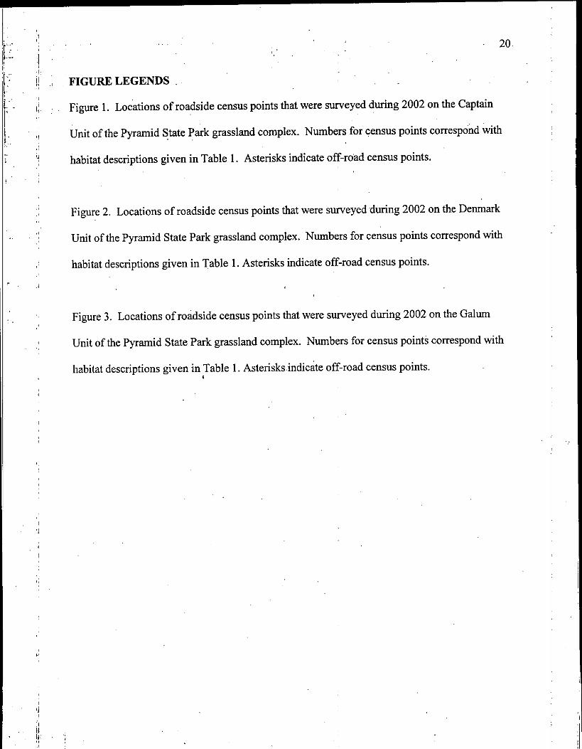
FIGURE LEGENDS .
Figure 1 . Locations of roadside census points that were surveyed during 2002 on the Captain
Unit of the Pyramid State Park grassland complex . Numbers for census points correspond with
habitat descriptions given in Table 1 . Asterisks indicate offroad census points .
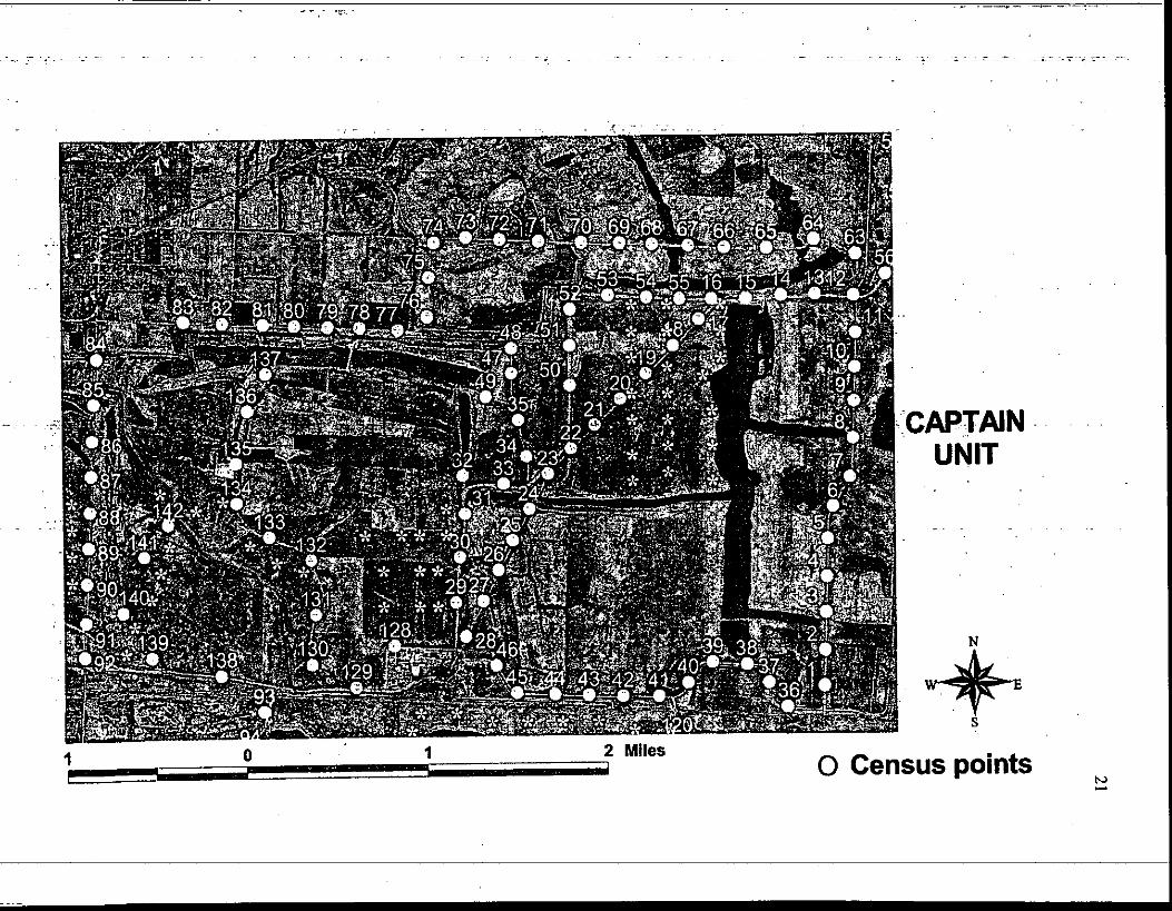
Figure 2. Locations of roadside census points that were surveyed during 2002 on the Denmark
Unit of the Pyramid State Park grassland complex . Numbers for census points correspond with
habitat descriptions given in Table 1 . Asterisks indicate off-road census points .
Figure 3 . Locations of roadside census points that were surveyed during 2002 on the Galum
Unit of the Pyramid State Park grassland complex . Numbers for census points correspond with
habitat descriptions given in Table 1 . Asterisks .indicate off-road census points .
I
20
NN

s-
-GALUMUNIT
O Census pointsNW
24
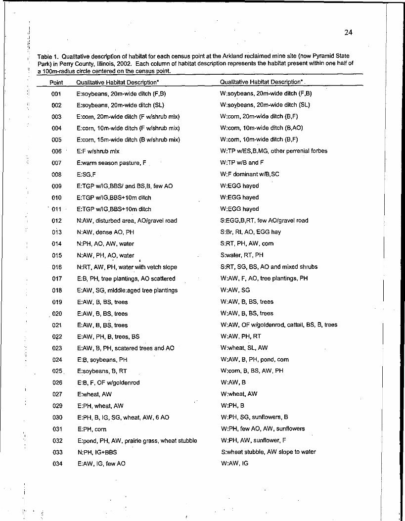
Table 1 . Qualitative description of habitat for each census point at the Arkland reclaimed mine site (now Pyramid StatePark) in Perry County, Illinois, 2002 . Each column of habitat description represents the habitat present within one half ofa 1 OOm-radius circle centered on the census point .
Point Qualitative Habitat Description* Qualitative Habitat Description* .
001 E:soybeans, 20m-wide ditch (F,B) W:soybeans, 20m-wide ditch (F,B)
002 E:soybeans, 20m-wide ditch (SL) W:soybeans, 20m-wide ditch (SL)
003 E:corn, 20m-wide ditch (F w/shrub mix) W:corn, 20m-wide ditch (B,F)
004 E:corn, 10m-wide ditch (F w/shrub mix) W:com, 10m-wide ditch (B,AO)
005 E:corn, 15m-wide ditch (B w/shrub mix) W:corn, 10m-wide ditch (B,F)
006 E:F w/shrub mix W:TP w/ES,B,MG, other perrenial forbes
007 E:warm season pasture, F W:TP w/B and F
008 E:SG,F W:F dominant w/B,SC
009 E:TGP w/IG,BBS/ and BS,B, few AO W:EGG hayed
010 E:TGP w/IG,BBS+lOm ditch W:EGG hayed
Oil E:TGP w/IG,BBS+l Om ditch W:EGG hayed
012 N:AW, disturbed area, AO/gravel road S:EGG,B,RT, few AO/gravel road
013 N :AW, dense AO, PH S :Br, Rt, AO, EGG hay
014 N:PH, AO, AW, water S :RT, PH, AW, corn
015 N:AW, PH, AO, water S:water, RT, PH
016 N:RT, AW, PH, water with vetch slope S:RT, SG, BS, AO and mixed shrubs
017 E:B, PH, tree plantings, AO scattered WAW, F, AO, tree plantings, PH
018 E:AW, SG, middle :aged tree plantings W :AW,SG
019 E:AW, B, BS, trees W:AW, B, BS, trees
020 E:AW, B, BS, trees W:AW, B, BS, trees
021 E:AW, B, BS, trees W:AW, OF w/goldenrod, cattail, BS, B, trees
022 E:AW, PH, B, trees, BS W:AW, PH, RT
023 E:AW, B, PH, scatered trees and AO W:wheat, SL, AW
024 E:B, soybeans, PH W:AW, B, PH, pond, corn
025 . E:soybeans, B, RT W:com, B, BS, AW, PH
026 E:B, F, OF w/goldenrod W:AW, B
027 E:wheat, AW W:wheat, AW
029 E:PH, wheat, AW W:PH, B
030 E:PH, B, IG, SG, wheat, AW, 6 AO W:PH, SG, sunflowers, B
031 E:PH, corn W :PH, few AO, AW, sunflowers
032 E:pond, PH, AW, prairie grass, wheat stubble W :PH, AW, sunflower, F
033 N:PH, IG+BBS S:wheat stubble, AW slope to water
034 E:AW, IG, few AO W :AW, IG
25
Table 1 . Qualitative description of habitat for each census point at the Arkland reclaimed mine site (now Pyramid StatePark) in Perry County, Illinois, 2002 . Each column of habitat description represents the habitat present within one half ofa 100m-radius circle centered on the census point
Point Qualitative Habitat Description' Qualitative Habitat Description*
035 E:AW, IG W:PH, AW, IG
036 N:F, SG, pond w/trdeline S:F, ACT w/mixed woodies
037 N:F, pond w/treeline S:F, ACT, OF, young trees
038 N:F, little TGP, PH, pond S:F, PH, hayfield, few woodies along fence
039 N:F, PH, pond S:F, hayfield, pasture, tree row
040 N:PH, SL, W rim around pond S:F, W, GR, wooded ravine
041 N:F, BS, SL, GR, scattered W S:F slope, PH, pond, young trees
042 N:F, PH, tree planting w/RT+BS+B S:F, PH, young trees
043 . N:F, PH, tree planting w/cool season grasses S:F, PH, young trees, pond
044 N:soybeans, ditch w/B+F+SG S:F, B, woodies, railroad
045 N:B, OF, PH, soybeans S:mowed F, woodies, road, railroad
046 N:F, PH, OF w/B+F S:PH, F, woodies, road, shallow water
047 E:PH, prairie grass W:F, AW roadside
048 E:AW, RT, SG W:RT, F, PH, AW
049 N:F, RT slope, water S:F, TGP, AW
050 E:RT, B, tree planting W:RT, BR, IG+few AO+few W
051 E:RT, SG, prairie . W:RT, PH, B
052 E:RT, PH, tree planting w/B W:RT, PH, B, scattered woodies
053 N:RT, AW, PH, water with vetch slope S:RT, SG, tree plantings w/OF
054 N:RT, AW, PH, water with vetch slope S:RT, SG, PH, few AO
055 N :RT, AW, PH, water with vetch slope S:RT, SG, BS, few AO and W
056 N :SG,PH,wheat SAO w/young mixed woodies, wheat
057 E:wheat, ACT W :wheat stuble, B, small trees, few AO .
058 E:wheat W :15m of wheat, ACT w/F
059 E:wheat W :15m of wheat w/AW, AOT w/B
060 E.-wheat W:15m of wheat, ACT, OF w/goldenrod, PH
061 N:OF w/ SL, F, PH, AO S:slope of lakeside, annuals, disturbed
062 N :wheat w/AW S:ditch with AW, wheat
063 N:AOT, F, young forest S:SL, stream, pond
064 N:F, AO, PH, pond S:F, PH, pond, SC, few AO
065 N:F, few AO sprayed S:F, few AO
066 N:F, ACT, W S:PH, F dominant, few mixed shrubs
067 N:PH, pond S:F, PH, pond

Table 1. Qualitative description of habitat for each census point at the Arkland reclaimed mine site (now Pyramid StatePark) in Perry County, Illinois, 2002 . Each column of habitat description represents the habitat present within one half ofa 100m-radius circle centered on the census point.
PointQualitative Habitat Description`Qualitative Habitat Description'
068
N:PH, pond
'069
N:F, BS, AO rows
070
N:BS, F, PH, pond
071
N:F roadside, corn
072
N:F roadside, soybeans
073
N:F, OF, AO scattered
074
N:F, few shrub, cattail
075
N:F, AO scattered
076
NIBS, OF w/goldenrod, AO scattered
077
N:woody fence row, corn
078
N:F pasture, soybeans
079
N:soybeans, woody fence row
080
N:woody fence. row, soybeans
081
N:soybeans
082
N:soybeans, tree fence row
083
N:soybeans, tree fence row
084
E:F, AOT, W, OF
085
E:AW
086
E:AW, PH, few W
087
E:AW
088
E:AW
089
E:AW
090
E:B, PT, RT, AW
091
E:F, AW
092,
E:B, F, scattered mixed shrubs
093
E:gravel, AW, woods
094
E:B, AW, gravel, AO clumps
095
E:milo, B, F
096
E:com, B, F
097
E:com, B, F
098
E:B, F ditch, goldenrod
099
E:F, OF, shrubs/trees, TGP WIG
100
E:13, W, CV
S:F, PH, pond, AO in rows
S:F, BS, mullen, 3 AO
S:F, BS, AO row
S:F, corn, OF w/goldenrod
S:OF w/goldenrod roadside, corn, AD fencerow
S:B roadside, corn
S:OF roadside, corn
SAW, F, AO scattered, PH
SAW, BS, OF, ditch, few AO
S:OF ,w/goldenrod, TGP (IG+BBS)
S:OF w/goldenrod, TGP (IG+BBS)
S:RT, OF w/goldenrod, BBS, IG, AO bunch
S:OF w/goldenrod, TGP (IG+BBS)
S:OF w/goldenrod, TGP (IG+BBS), RT
S:OF w/goldenrod, TGP (IG+BBS), F
S:soybeans, OF w/goldenrod, IG, BBS, forest
W :AO, mixed woodies, OF, F
W :pond, F, SC, OF, 2 AO
W :pond, AW pasture
W:F pasture
W:F pasture
W:moist soil, F pasture, dropseed
W:PT+SG+AW pasture
W:F, SG, AW, cattail, few mixed shrubs
W:B, F, black locust, AW
W:gravel, AW, woods
W:AW, AO row, water
W :F, AW+F pasture, few shrubs, powerline
W :F, mixed grass pasture, powerline
W:F, mixed grass pasture, powerline
W:F, pasture, powerline
W:F, pasture, AO along road, powerline
W:forest, abandoned homestead
26
Qualitative Habitat Description'
N:W, water, F, AO
E:F, F pasture, OF, woodies
E:F, pasture, AW
E:F, EGG, few AO
E:com, goldenrod, B, row of AO, EGG
106
N:EGG, B, SL ditch, AO scattered
107
N:EGG hayed, SC, PH, sunflower
108
E:soybean, B, tree planing w/B
,109
N:B, GR, water ditch, EGG hayed
110
N:B, F, F pasture, AO patches
111
N:F, B, PH, scattered AO
112
N:F, B, PH, scattered AO
113
N:B, F pasture, OF, scattered AO
114
N:F, RC, OF, W and ACT
105
115 N:PH, OF, scattered trees and AO, notill soybeans
S:B, OF, scattered AOr
116
E:F, CV, water, PH
117
E:B, RT, PH, water
118
E:B, PH, water
119
E:young tree planting in B+F
120
N:F
121
122
123
124
125
126
127
128
129
130
131
132
133
E:F in ditch, ACT, W, pond
E:F, SW, AOT
E:OF, PH, W grove
N:notill soybeans
E:com, F, 2 big trees
E:prairie planting, F, soybeans
N:soybeans, wheat, AW, 3 AO
N:PH, B, AO scattered, water
N:AW, PH, water, few trees and shrubs
E:AW, PH, cattails, goldenrod, F
E:soybeans, AW, B, SG
E:soybeans, PH, foxtail, tree plantings
E:RT, AW, B, tree plantings
Qualitative Habitat Description*
S:F
W:B, OF, scattered woodies
W:B, AW
W:RT, B, water, CV
W:B, PH, water
S:EGG, B, little pasture
S:EGG hayed, SC, B, PH, goldenrod
W:B. B slope, water, PH, few W
S:water, PH, B
S:B, AO woody thicket, F pasture w/few AO
S :B, woody savanna, AO, F pasture
S :B, woody savanna, AO, F pasture
S :B, OF, scattered trees, AOT
S :F, PH, scattered AO
W:B, wheat stubble now soybeans
W:com, B edge
Wires planting w/B, OF
W:B ditch, prairie grass hayed
S:water, AW and W strip
W:F, B, AO scattered
W:F, AO, lake
W:AW, wheat stubble, OF, AO patch
S:F, OF, scattered AO, willow ditch
W:soybeans, F ditch
W:AW, RT, disturbed field, woodlot
S:soybeans, woodlot
S:gravel
S:gravel, PH, railroad
W:B,'SG
W:B, SG
W:B, SG, F, AO scattered
W:B, F, PH
27
Table 1! Qualitative description of habitat for each census point at the Arkland reclaimed mine site (now Pyramid StatePark) in Perry County, Illinois, 2002 . Each column of habitat description represents the habitat present within one half ofa 100m-radius circle centered on the census point.
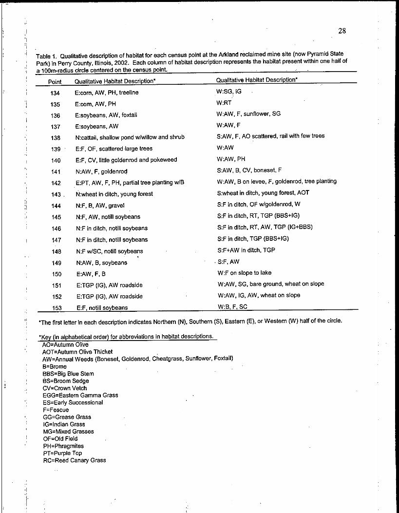
28
Table 1 . Qualitative description of habitat for each census point at the Arkland reclaimed mine site (now Pyramid StatePark) in Perry County, Illinois, 2002 . Each column of habitat description represents the habitat present within one half ofa 100m-radius circle centered on the census point.
'The first letter in each description indicates Northern (N), Southern (S), Eastern (E), or Western (W) half of the circle .
*Key (in alphabetical order) for abbreviations in habitat descriptions .AO=Autumn OliveAOT=Autumn Olive ThicketAW=Annual Weeds (Boneset, Goldenrod, Cheatgrass, Sunflower, Foxtail)B=BromeBBS=Big Blue StemBS=Broom SedgeCV=Crown VetchEGG=Eastern Gamma GrassES=Early SuccessionalF=FescueGG=Grease GrassIG=Indian GrassMG=Mixed GrassesOF=Old FieldPH=PhragmitesPT=Purple TopRC=Reed Canary Grass
Point Qualitative Habitat Description' Qualitative Habitat Description'
134 E:com, AW, PH, treeline W:SG, IG
135 E:com, AW, PH W:RT
136 E:soybeans, AW, foxtail W :AW, F, sunflower, SG
137 E:soybeans, AW W:AW, F
138 N:cattail, shallow pond w/willow and shrub SAW, F, AO scattered, rail with few trees
139 E:F, OF, scattered large trees W:AW
140 E:F, CV, little goldenrod and pokeweed W:AW, PH
141 N:AW, F, goldenrod SAW, B, CV, boneset, F
142 E:PT, AW, F, PH, partial tree planting w/B W:AW, B on levee, F, goldenrod, tree planting
143 . N:wheat in ditch, young forest S :wheat in ditch, young forest, ACT
144 N:F, B, AW, gravel S:F in ditch, OF w/goldenrod, W
145 N:F, AW, notill soybeans S:F in ditch, RT, TGP (BBS+IG)
146 N:F in ditch, notill soybeans S:F in ditch, RT, AW, TGP (IG+BBS)
147 N:F in ditch, notill soybeans S:F in ditch, TGP (BBS+IG)
148 N:F w/SC, notill soybeans S:F+AW in ditch, TGP
149 N:AW, B, soybeans S:F, AW
150 E:AW, F, B W:F on slope to lake
151 E:TGP (IG), AW roadside W:AW, SG, bare ground, wheat on slope
152 E:TGP (IG), AW roadside W :AW, IG, AW, wheat on slope
153 E:F, notill soybeans W :B, F, SC
Table 11' Qualitative description of habitat for each census point at the Arkland reclaimed mine site (now Pyramid StatePark) in Perry County, Illinois, 2002 . Each column of habitat description represents the habitat present within one half ofa 100m-radius circle centered on the census point .
PointQualitative Habitat Description`Qualitative Habitat Description'
'Key continued for abbreviations in habitat descriptions .RT=Red TopSC=Sweet CloverSG=Switch GrassSL=Serecia LespedizaTGP=Tall Grass PrairieTP=Tree PlantingW=Willow
29
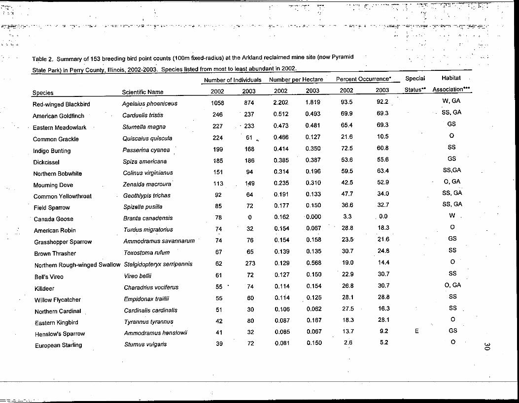
Table 2. Summary of 153 breeding bird point counts (100m fixed-radius) at the Arkland reclaimed mine site (now Pyramid
State Park) in Perry County, Illinois, 2002-2003 . Species listed from most to least abundant in 2002 .
W0
Number of Individuals Number per Hectare Percent Occurrence - Special Habitat
Species Scientific Name 2002 2003 2002 2003 2002 2003 Status" Association`
Red-winged Blackbird Agelaius phoeniceus 1058 874 2 .202 1 .819 93 .5 92.2 W, GA
American Goldfinch Carduelis tristis 246 237 0 .512 0.493 69 .9 69.3 SS, GA
Eastern Meadowlark Stumella magna 227 233 0.473 0.481 65.4 69.3 GS
Common Grackle Quiscalus quiscula 224 61 0.466 0.127 21 .6 10 .5 0
Indigo Bunting Passerina cyanea 199 168 0.414 0.350 72.5 60.8 SS
Dickcissel Spiza americana 185 186 0.385 0.387 53.6 55.6 GS
Northern Bobwhite Colinus virginianus 151 94 0.314 0.196 59.5 63.4 SS,GA
Mourning Dove Zenaida macroura 113 1,49 0.235 0.310 42.5 52 .9 0, GA
Common Yellowthroat Geothlypis trichas 92 64 0.191 0.133 47.7 34.0 SS, GA
Field Sparrow Spizella pusilla 85 72 0.177 0.150 36.6 32.7 SS, GA
Canada Goose Branta canadensis 78 0 0.162 0.000 3.3 0.0 W .
American Robin Turdus migratorius 74 32 0.154 0 .067 28.8 18.3 0
Grasshopper Sparrow Ammodramus savannamm 74 76 0.154 0 .158 23.5 21 .6 GS
Brown Thrasher Toxostoma rufum 67 65 0.139 0.135 30 .7 24.8 SS
Northern Rough-winged Swallow Stelgidopteryx serripennis 62 273 0.129 0.568 19.0 14.4 0
Bell's Vireo Vireo bellii 61 72 0.127 0.150 22.9 30.7 SS
Killdeer Charadrius vociferus 55 74 0.114 0.154 26.8 30.7 0, GA
Willow Flycatcher Empidonax traillii 55 60 0.114 0.125 28 .1 28.8 SS
Northern Cardinal . Cardinalis cardinalis 51 30 0.106 0.062 27.5 16.3 SS
Eastern Kingbird Tyrannus tyrannus 42 80 0.087 0.167 18 .3 28 .1 0
Henslow's Sparrow Ammodramus henslowii 41 32 0.085 0.067 13 .7 9.2 E GS
European Starling Stumus vulgaris 39 72 0.081 0.150 2.6 5.2 0
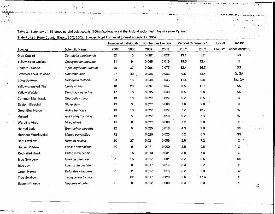
Species
Table 2. Summary of 153 breeding bird point counts (100m fixed-radius) at the Arkland reclaimed mine site (now Pyramid
State Park) in Perry County, Illinois, 2002-2003 . Species listed from most to least abundant in 2002 .
Number of Individuals Number per HectarePercent Occurrence-
Scientific Name
Special
2002
2003
2002
2003
2002
2003
Status"
Habitat
Association***
Gray Catbird Dumetella carolinensis 32 13 0.067 0.027 13.1 7.2 SS
Yellow-billed Cuckoo Coccyzus americanus 31 9 0 .065 0.019 19.0 12.4 0
Eastern Towhee Pipilo erythrophthalmus 28 37 0.058 0.077 12.4 15.L SS
Brown-headed Cowbird Molothrus ater 27 40 0.056 0.083 9.8 12.4 0, GA
Song Sparrow Melospiza melodia 23 16 0.048 0.033 11 .8 9.8 SS, GA
Yellow-breasted Chat Icteria virens 18 20 0.037 0.042 9.8 11 .1 SS
Yellow Warbler Dendroica petechia 17 16 0 .035 0.033 8 .5 9.8 SS
Common Nighthawk Chordeiles minor 13 13 0.027 0.027 5.2 6.5 0
Eastern Bluebird ' Sialia sialis 13 3 0.027 0.006 7.8 2.0 0
Great Blue Heron Ardea herodias 13 13 0 .027 0.027 7.2 13.7 W
Mallard Anas platyrhynchos 13 5 0.027 0.010 5.2 3.3 W
Warbling Vireo Vireo gilvus 13 0 0 .027 0.000 7.2 0.0 0
Horned Lark Eremophila alpestris 12 5 0 .025 0.010 4.6 2.0 GS
Northern Mockingbird Mimus polyglottos 12 11 0 .025 0.023 5.2 6.5 SS
Barn Swallow Hirundo rustica 10 27 0 .021 0.056 2.6 7.2 0
House Sparrow Passer domesticus 10 0 0.021 0.000 2.0 0.0 0
Red-tailed Hawk Buteojamiacensis 9 15 0 .019 0.031 5.9 7.8 0
Blue Grosbeak Guiraca caerulea 8 15 0 .017 0.031 5.2 8.5 SS
Blue Jay Cyanocitta cristata 8 8 0 .017 0.017 3.3 5.2 0
Green Heron Butoddes virescens 8 2 0 .017 0.013 5.2 2.0 W
Tree Swallow Tachycineta bicolor 8 62 0.017 0.129 2.6 17.6 0
Eastern Phoebe Sayomis phoebe 6 0 0 .012 0.000 3.3 0.0 0
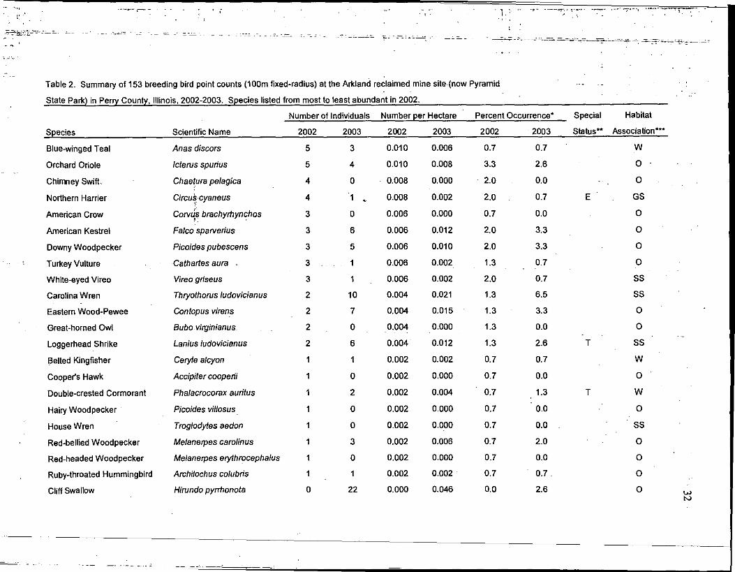
Table 2. Summary of 153 breeding bird point counts (100m fixed-radius) at the Arkland reclaimed mine site . (now Pyramid
State Park) in Perry County, Illinois, 2002-2003 . Species listed from most to least abundant in 2002 .
Number of Individuals Number per Hectare
Percent Occurrence`
Species
Scientific Name
2002
2003
2002
2003
2002
2003
Special
Habitat
Status" Association'
Blue-winged Teal Anas discors 5 3 0.010 0.006 0.7 0.7 W
Orchard Oriole Icterus spurius 5 4 0.010 0.008 3.3 2.6 0
Chimney Swift . Chaetura pelagica 4 0 0.008 0.000 2.0 0.0 0
Northern Harrier Circus cyaneus 4 1 0.008 0.002 2.0 0.7 GS
American Crow Corvus brachyrhynchos 3 0 0.006 0.000 0.7 0.0 0
American Kestrel Falco sparverius 3 6 0.006 0.012 2.0 3.3 0
Downy Woodpecker Picoides pubescens 3 5 0.006 0.010 2.0 3.3 0
Turkey Vulture Cathartes aura . 3 1 0.006 0.002 1 .3 0.7 0
White-eyed Vireo Vireo griseus 3 1 0.006 0.002 2.0 0.7 SS
Carolina Wren Thryothorus ludovicianus 2 10 0.004 0.021 1 .3 6.5 SS
Eastern Wood-Pewee Contopus virens 2 7 0.004 0.015 1 .3 3.3 0
Great-horned Owl Bubo virginianus 2 0 0.004 0.000 1 .3 0.0 0
Loggerhead Shrike Lanius ludovicianus 2 6 0.004 0.012 1 .3 2.6 SS
Belted Kingfisher Ceryle alcyon 1 1 0.002 0.002 0.7 0.7 W
Cooper's Hawk Accipiter cooperii 1 0 0.002 0.000 0.7 0.0 0
Double-crested Cormorant Phalacrocorax auritus 1 2 0.002 0.004 0.7 1 .3 T W
Hairy Woodpecker Picoides villosus 1 0 0 .002 0.000 0.7 0.0 0
House Wren Troglodytes aedon 1 0 0 .002 0.000 0.7 0.0 SS
Red-bellied Woodpecker Melanerpes carolinus 1 3 0.002 0.006 0.7 2.0 0
Red-headed Woodpecker Melanerpes erythrocephalus 1 0 0 .002 0.000 0.7 0.0 0
Ruby-throated Hummingbird Archilochus colubris 1 1 0.002 0.002 0.7 0.7- 0
Cliff swallow Hirundo pyrrhonota 0 22 0.000 0.046 0.0 2.6
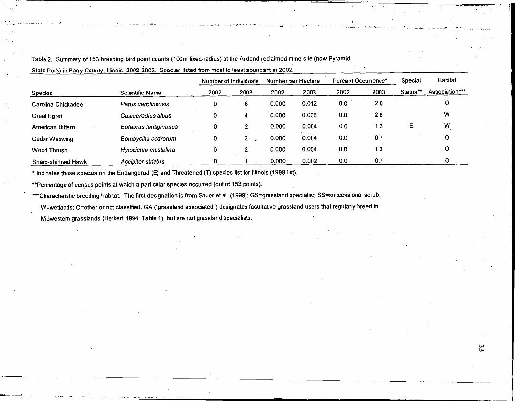
Table 2. Summary of 153 breeding bird point counts (100m fixed-radius) at the Arkland reclaimed mine site (now Pyramid
State Park) in Perry County, Illinois, 2002-2003 . Species listed from most to least abundant in 2002 .
Number of Individuals Number per HectarePercent Occurrence*
Special
Habitat
Scientific Name
2002
2003
2002
2003
2002
2003
Status" Association***Species
* Indicates those species on the Endangered (E) and Threatened (T) species list for Illinois (1999 list) .
**Percentage of census points at which a particular species occurred (out of 153 points) .
***Characteristic breeding habitat . The first designation is from Sauer et al . (1999) : GS=grassland specialist; SS=successional scrub ;
W=wetlands; O=other or not classified . GA ("grassland associated") designates facultative grassland users that regularly breed in
Midwestern grasslands (Herkert 1994 : Table 1), but are not grassland specialists .
I
Carolina Chickadee Pares carolinensis 0 6 0.000 0.012 0 .0 2.0 0
Great Egret Casmerodius albus 0 4 0.000 0.008 0 .0 2.6 W
American Bittern Botaurus lentiginosus 0 2 0.000 0.004 0.0 1 .3 E W
Cedar Waxwing Bombycilla cedrorum 0 2 0.000 0.004 0.0 0.7 0
Wood Thrush Hylocichla mustelina 0 2 0.000 0.004 0 .0 1 .3 0
Sharp-shinned Hawk Accipiter striatus 0 1 0.000 0.002 0.0 0.7 0
Table 3. Summary of 133 off-road breeding bird point counts (100m fixed-radius) at the Arkland reclaimed mine site
(now Pyramid State Park) in Perry County, Illinois, 2003. Species listed from most to least abundant.
34
I
Species Scientific Name
Number of
Individuals
Number per
Hectare
Special
Status*
Habitat
Association"
Red-winged Blackbird Agelaius phoeniceus 804 1 .925 W, GA
Eastern Meadowlark Stumella magna 224 0.536 GS
Dickcissel Spiza americans 146 0.350 GS
Common Grackle Quiscalus quiscula 109 0.261 0
Northern Bobwhite Colinus virginianus 89 0.213 SS,GA
Indigo Bunting Passerina cyanea 77 0.184 SS
Brown-headed Cowbird Molothrus ater 69 0.165 0, GA
American Goldfinch Carduelis tristis 64 0.153 SS, GA
Field Sparrow Spizella pusilla 63 0.151 SS, GA
Mourning Dove Zenaida macroura 57 0.136 0, GA
Barn Swallow Hirundo rustica 51 0.122 0
Grasshopper Sparrow Ammodramus savannarum 50 0 .120 GS
Yellow Warbler Dendroica petechia 40 0.301 SS
Bell's Vireo Vireo bellii 35 0.084 SS
American Robin Turdus migratorius 30 0 .072 0
Common Yellowthroat Geothlypis trichas 29 0 .069 SS, GA
Willow Flycatcher Empidonax traillii 27 0.065 SS
Henslow's Sparrow Ammodramus henslowii 23 0.055 E GS
Northern Rough-winged Swallow Stelgidopteryx serripennis 21 0.050 0
Eastern Kingbird Tyrannus tyrannus 19 0.045 0
Killdeer Charadrius vociferus 18 0.043 0, GA
Brown Thrasher Toxostoma rufum 14 0.034 SS
Northern Cardinal Cardinalis cardinalis 14 0 .034 SS
Canada Goose Branta canadensis 13 0.031 W
Horned Lark Eremophila alpestris 10 0.024 GS
Cedar Waxwing Bombycilla cedrorum 10 0.024 0
Yellow-billed Cuckoo Coccyzus americanus 9 0.022 0
Yellow-breasted Chat Icteria virens 8 0.019 SS
Gray Catbird Dumetella carolinensis 7 0.017 SS
Song Sparrow Melospiza melodia 6 0.014 SS, GA
Warbling Vireo Vireo gilvus 6 0.014 0
Blue Grosbeak Guiraca caerulea 6 0.014 SS
Table 3. Summary of 133 off-road breeding bird point counts (100m fixed-radius) at the Arkiand reclaimed mine site
(now Pyramid State Park) in Perry County, Illinois, 2003 . Species listed from most to least abundant.
35
Species Scientific Name
Number of
Individuals
Number per
Hectare
Special
Status'
Habitat
Association"
Blue Jay Cyanocltta cristata 6 0.014 0
Tree Swallow Tachycineta bicolor 6 0.014 0
Cliff Swallow Hirundo pyrrhonota 6 0 .045 0
Eastern Towhee Pipilo erythrophthalmus 4 0.010 SS
Mallard Anas platyrhynchos 4 0.010 W
Green Heron Butorides virescens 4 0.010 W
Blue-winged Teal Anas discors 4 0.010 W
Downy Woodpecker Picoides pubescens 4 0.010 0
Great Blue Heron Ardea herodias 3 0.007 W
House Sparrow Passer domesticus 3 0.007 0
Blue-gray Gnatcatcher Polioptila caerulea 3 0.007 0
Orchard Oriole Icterus spurius 2 0.005 0
European Starling Sturnus vulgaris 1 0.002 0
Common Nighthawk Chordeiles minor 1 0.002 0
Northern Mockingbird Mimus polyglottos 1 0 .002 SS
Red-tailed Hawk Buteo jamiacensis 1 0 .002 0
Eastern Phoebe Sayomis phoebe 1 0.002 0
Northern Harrier Circus cyaneus 1 0.002 E GS
American Crow Corvus brachyrhynchos 1 0.002 0
American Kestrel Falco sparvedus 1 0.002 0
Turkey Vulture Cathartes aura 1 0.002 0
White-eyed Vireo Vireo griseus 1 0.002 SS
Eastern Wood-Pewee Contopus virens 1 0.002 0
House Wren Troglodytes aedon 1 0 .002 SS
Red-bellied Woodpecker Melanerpes carolinus 1 0 .002 0
American Bittern Botaurus lentiginosus 1 0.002 E W
Baltimore Oriole Icterus galbula 1 0.002 ' 0
Least Bittern Ixobrychus exilis 1 0.002 T W
Purple Martin Progne subis 1 0.002 0
Eastern Bluebird Sialia sialis 0.000 0
Chimney Swift Chaetura pelagica 0.000 0
Carolina Wren Thryothorus ludovicianus 0.000 SS
Table 3. Summary of 133 off-road breeding bird point counts (100m fixed-radius) at the Arkland reclaimed mine site
(now Pyramid State Park) in Perry County, Illinois, 2003 . Species listed from most to least abundant
* Indicates those species on the Endangered (E) and Threatened (T) species list for Illinois .
**Characteristic breeding habitat. The first designation is from Sauer et al . (1999) : GS=grassland specialist ;
SS=successional scrub ; W=wetlands ; O=other or not classified . GA ("grassland associated") designates
facultative grassland users that regularly breed in Midwestern grasslands (Herkert 1994 : Table 1), but are
not grassland specialists .
***Species documented at roadside census points in either 2002, 2003, or both .
****Species was present (P) and observed on site, but not within 100 m of any of the census points .
36
Species Scientific Name
Number of
Individuals
Number per
Hectare
Special
Status*
Habitat
Association**
Great-homed Owl Bubo virginianus 0.000 0
Loggerhead Shrike Lanius ludovicianus 0*** 0.000 T SS
Belted Kingfisher Ceryle alcyon 0.000 W
Cooper's Hawk Accipiter cooperii 0.000 0
Double-crested Cormorant Phalacrocorax auritus 0.000 T W
Hairy Woodpecker Picoides villosus 0.000 0
Red-headed Woodpecker Melanerpes erythrocephalus 0.000 0
Ruby-throated Hummingbird Archilochus colubris 0*** 0.000 0
Carolina Chickadee Parus carolinensis 0.000 0
Great Egret Casmerodius albus 0.000 W
Wood Thrush Hylocichla mustelina 0.000 0
Sharp-shinned Hawk Accipiter striatus 0*•** 0.000 0
Rough-legged Hawk
Cattle Egret
Little Blue Heron
Buteo lagopus
Bubulcus ibis
Egretta caerulea
P****
P****
P**** E
0
W
W
Spotted Sandpiper
Pied-billed Grebe
Actitis macularia
Podil ymbus podiceps T
0
W
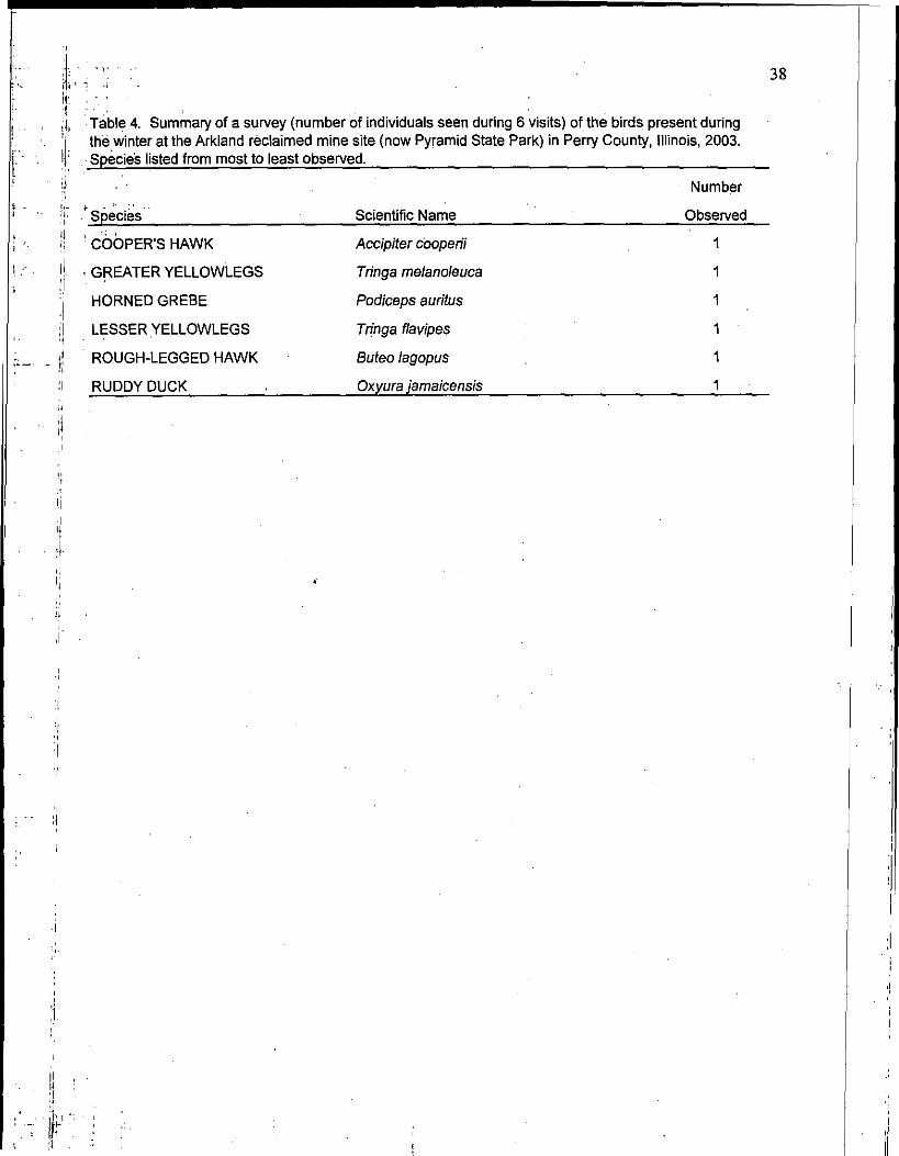
Table 4. Summary of a survey (number of individuals seen during 6 visits) of the birds present duringthe winter at the Arkland reclaimed mine site (now Pyramid State Park) in Perry County, Illinois, 2003 .Species listed from most to least observed .
37
Species Scientific Name
Number
Observed
SNOW GOOSE Chen caerulescens 9662
CANADA GOOSE Branta canadensis 1926
AMERICAN COOT Fulica americana 546
MALLARD Anas platyrhynchos 425
GAD WALL Anas strepera 157
LESSER SCALP Aythya affinis 154
NORTHERN HARRIER Buteo lagopus 128
COMMON MERGANSER Mergus merganser 117
NORTHERN SHOVELER Anas clypeata 116
BLUE-WINGED TEAL Anas discors 103
BUFFLEHEAD Bucephala albeola 51
GREEN-WINGED TEAL Anas crecca 43
RING-NECKED DUCK Aythya collaris 36
SHORT-EARED OWL Asio flammeus 34
KILLDEER Charadrius vociferus 33
REDHEAD Aythya americana 27
AMERICAN KESTREL Falco sparverius 24
RED-TAILED HAWK Buteojamiacensis 24
GREATER WHITE-FRONTED GOOSE Anser albifrons 21
COMMON SNIPE Gallinago gallinago 20
PIED-BILLED GREBE Podilymbus podiceps 13
LOGGERHEAD SHRIKE Lanius ludovicianus 11
RING-BILLED GULL Larus delawarensis 11
DOUBLE-CRESTED CORMORANT Phalacrocorax auritus 9
GREAT BLUE HERON Ardea herodias 9
TURKEY VULTURE Cathartes aura 4
AMERICAN WIDGEON Anas americana 2
BALD EAGLE Haliaeetus leucocephalus 2
NORTHERN PINTAIL Anas acute 2
I,-
k, Table 4. Summary of a survey (number of individuals seen during 6 visits) of the birds present duringthe winter at the Arkland reclaimed mine site (now Pyramid State Park) in Perry County, Illinois, 2003 .
f' Species listed from most to least observed .
38
Species Scientific Name
Number
Observed
COOPER'S HAWK Accipiter cooperii I
GREATER YELLOWLEGS Tringa melanoleuca 1
HORNED GREBE Podiceps auritus 1
LESSER YELLOWLEGS Tringa flavipes 1
ROUGH-LEGGED HAWK Buteo lagopus I
RUDDY DUCK Oxyura jamaicensis 1
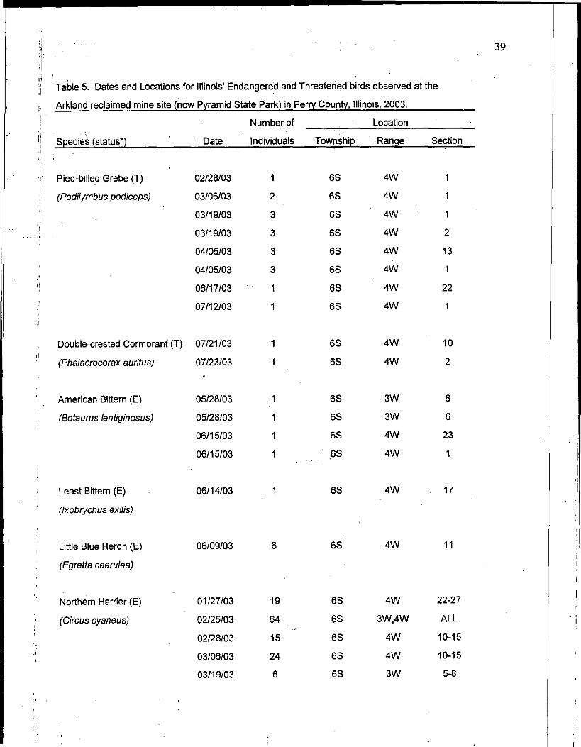
Table 5. Dates and Locations for Illinois' Endangered and Threatened birds observed at the
Arkland reclaimed mine site (now Pyramid State Park) in Perry County, Illinois, 2003 .
39
I
Species (status*) Date
Number of
Individuals
Location
Township Range Section
Pied-billed Grebe (T) 02/28/03 1 6S 4W 1
(Podilymbus podiceps) 03/06/03 2 6S 4W 1
03/19/03 3 6S 4W 1
03/19/03 3 6S 4W 2
04/05/03 3 6S 4W 13
04/05/03 3 6S 4W 1
06/17/03 1 6S 4W 22
07/12/03 1 6S 4W 1
Double-crested Cormorant (T) 07/21/03 1 6S 4W 10
(Phalacrocorax auritus) 07/23/03Y
1 6S 4W 2
American Bittern (E) 05/28/03 6S 3W 6
(Botaurus lentiginosus) 05/28/03 1 6S 3W 6
06/15/03 1 6S 4W 23
06/15/03 1 6S 4W 1
Least Bittern (E)
(Ixobrychus exilis)
06/14/03 6S 4W 17
Little Blue Heron (E)
(Egretta caerulea)
06/09/03 6 6S 4W 11
Northern Harrier (E) 01/27/03 19 6S 4W 22-27
(Circus cyaneus) 02/25103 64 6S 3W,4W ALL
02/28/03 15 6S 4W 10-15
03/06/03 24 6S 4W 10-15
03/19/03 6 6S 3W 5-8
Table 5. Dates and Locations for Illinois' Endangered and Threatened birds observed at the
Arkland reclaimed mine site (now Pyramid State Park) in Perry County, Illinois, 2003 .
40
Species (status*) Date
Number of
Individuals
Location
Township Range Section
Northern Harrier (E) 04/05/03 4 6S 3W 5.6
(Circus cyaneus) 07/21/03 1 6S 4W 14
Osprey (E)
(Pandion ha/iaetus)
06/20/03 1 6S 3W 7
Bald Eagle (T) 01/27/03 2 6S 4W 12
(Haliaeetus leucocephalus) 04/05/03 1 6S 4W 13
05/23/03 1 6S 4W 7
Upland Sandpiper (E) 06/17/03 1 6S 4W 27
(Bartramia Iongicauda) 06117/03Y
6S 4W 26
Short-eared Owl (E) 01/27/03 6S 4W 22
(Asio flammeus) 01/27/03 6 6S 4W 12
.02/28/03 1 6S 4W 2
03/19/03 20 6S 4W 11
Loggerhead Shrike (T) . 01/27/03 1 6S 4W 2
(Lanius Iudovicianus) 02/28/03 1 6S 4W 3
03/06/03 1 6S 4W 3
03/06/03 1 6S 4W 12
03/06/03 1 6S 4W 26
03/19/03 1 6S 4W 26
04/05/03 1 6S 4W 13
04/05/03 1 6S 4W 11
04/05/03 1 6S 4W 21
04/05/03 2 6S 4W 28
05/28/03 1 6S 4W 3

Table 5. Dates and Locations for Illinois' Endangered and Threatened birds observed at the
Arkland reclaimed mine site (now Pyramid State Park) in Perry County, Illinois, 2003 .
{
41
Species (status*) Date
Number of Location
Individuals Township Range Section
Loggerhead Shrike (T) 06/14/03 2 6S 4W 17
(Lanius ludovicianus) 06/15/03 1 6S 4W 28
06/15/03 1 6S 4W 28
06/20/03 2 6S 4W 28
07/23/03 2 6S 4W 2
07/23/03 2 6S 4W 16
Henslow's Sparrow (E) 06/09/03 2 6S 4W 2
(Ammodramus henslowii) 06/09/03 3 6S 4W 2
06/15/03 3 6S 4W 28
06/15/03 4 6S 4W 28
06/15/03 5 6S 4W 12
06/15/03 2 6S 4W 12
06/15/03 4 6S 4W 12
06/15/03 1 6S 4W 1
06/17/03 2 6S 4W 23
06/17/03 1 6S 4W 22
06/17/03 3 6S 4W 22
06/20/03 3 6S 4W 27
06/20/03 1 6S 4W 28
06/20/03 1 6S 4W 33
06/20/03 2 6S 4W 28
06/20/03 2 6S 4W 28
06/20/03 3 6S 4W 28
06/20/03 1 6S 4W 28
06/24/03 1 6S 4W 34
07/12/03 1 5S- 4W . 36
07/12/03 2 6S 3W 5
07/21/03 3 6S 4W 11
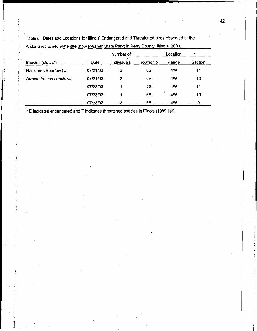
Table 5. Dates and Locations for Illinois' Endangered and Threatened birds observed at the
Arkland reclaimed mine site (now Pyramid State Park) in Perry County, Illinois, 2003 .
* E indicates endangered and T indicates threatened species in Illinois (1999 list) .
42
Species (status*) Date
Number of
Individuals
Location
Township Range Section
Henslow's Sparrow (E) 07/21/03 2 6S 4W 11
(Ammodramus henslowii) 07/21/03 2 6S 4W 10
07/23/03 1 5S 4W 11
07/23/03 1 6S 4W 10
07/23/03 3 6S 4W 9