monitoring system of the colombian …awr/wiki/downscaling/hydrooutlooks/... · agrometeorología...
TRANSCRIPT

Ministerio de Ambiente, Vivienda yDesarrollo Territorial
República de Colombia
Palisades, NY, USA, September 2010
TRAINING OF TRAINERS ON HYDROLOGICAL OUTLOOKS
AT IRI
MONITORING SYSTEM OF THE COLOMBIAN
HYDROLOGYClaudia Yaneth Contreras TrujilloSenior Engineer -Hydrology Department (IDEAM)
MSc Hydrology –PhD Student (UPV)

Ministerio de Ambiente, Vivienda yDesarrollo Territorial
República de ColombiaGEOGRAPHICAL LOCALIZATION
Mar Caribe
Océ
an
o P
acíf
ico
ECUADOR
PERÚ
BRASIL
VENEZUELA
A B
COLOMBIA

Ministerio de Ambiente, Vivienda yDesarrollo Territorial
República de ColombiaCOLOMBIA CROSS SECTION
Sea Level
5.000 m.a.s.l
A B

Ministerio de Ambiente, Vivienda yDesarrollo Territorial
República de ColombiaCLIMATE IN COLOMBIA
ITCZ (Intertropical Convergence Zone)
East Waves
Tropical Hurracains.
Cold and Warm fronts from the North Hemisf.
Local effects (Topography)

Ministerio de Ambiente, Vivienda yDesarrollo Territorial
República de Colombia
PRECIPITATION
( Annual Average)
0
20
40
60
80
100
120
JAN FAB MAR APR MAY JUN JUL AUG SEP OCT NOV DIC
Pre
cip
itació
n (
mm
)
0
50
100
150
200
250
300
JAN FAB MAR APR MAY JUN JUL AUG SEP OCT NOV DIC
Pre
cip
itació
n (
mm
)
0
200
400
600
800
1000
JAN MAR MAY JUL SEP NOV
Pre
cip
itació
n (
mm
)
0
200
400
600
800
1000
JAN MAR MAY JUL SEP NOV
Pre
cip
itació
n (
mm
)
0
100
200
300
400
JAN FAB MAR APR MAY JUN JUL AUG SEP OCT NOV DICP
recip
itació
n (
mm
)

Ministerio de Ambiente, Vivienda yDesarrollo Territorial
República de Colombia
TEMPERATURE
( Annual Average)

Ministerio de Ambiente, Vivienda yDesarrollo Territorial
República de Colombia DAILY VARIATION TEMPERATUREC
OM
PO
RT
AM
IEN
TO
DE
LA
S
T°
MIN
IMA
S E
N E
L A
LT
IPL
AN
O
CU
ND
I-B
OY
AC
EN
SE
A 2
mts
. F
EB
RE
RO
DE
20
07
-10,0-9,0-8,0-7,0-6,0-5,0-4,0-3,0-2,0-1,00,01,02,03,04,05,06,07,08,09,0
10,011,0
Gra
do
s C
els
ius
Eldorado
Bogoiá -6.4(M in. Abs.)
2547msnm
3,0 1,7 -1,9 -1,9 -2,4 -1,4 0,0 3,3 4,3 3,9 3,4 5,3 5,8 4,2 8,3 7,6 8,0 2,8 7,2 4,9 4,6 4,2 3,0 4,5 6,9 10,4 7,0 7,6
Surbata
Duitama -7.2(M ni. Abs.)
2485msnm
4,2 3,2 -0,7 -8,0 1,1 -1,4 -2,2 4,4 3,2 2,8 6,2 4,6 8,4 6,4 2,2 6,0 5,8 2,4 2,4 2,2 2,2 8,8 -0,4
UPTC
Tunja -1.1(M in. Abs.)
2690msnm
8,2 6,2 -0,4 1,8 2,6 2,8 2,4 7,0 5,2 6,4 8,4 8,2 7,0 9,0 7,4 7,6 3,2 5,0 5,8 4,2 5,0 0,4 3,8 4,6 8,2 5,4 6,4
Tunguavita
Paipa -8.0(M in. Abs.)
2470msnm
4,0 2,0 -4,4 -5,2 2,0 -0,4 -0,4 -3,0 3,0 3,4 2,0 5,0 7,0 4,0 8,4 8,8 6,0 1,4 5,0 5,2 2,0 1,8 0,8 1,0 6,0 9,0 -1,0 -1,6
Aerp. Lleras
Sogamoso -8.8(M in. Abs.)
2500msnm
-2,6 -3,0 -8,6 -8,4 -7,8 -2,8 -4,0 -4,2 -3,8 2,0 -3,2 -1,6 -1,2 7,2 7,6 3,0 1,8 4,0 0,2 3,0 -1,6 -4,0 -5,0 -4,8 0,8 7,2 -0,2 -2,6
M inima absoluta
Eldorado
-6,4 -6,4 -6,4 -6,4 -6,4 -6,4 -6,4 -6,4 -6,4 -6,4 -6,4 -6,4 -6,4 -6,4 -6,4 -6,4 -6,4 -6,4 -6,4 -6,4 -6,4 -6,4 -6,4 -6,4 -6,4 -6,4 -6,4 -6,4
1 2 3 4 5 6 7 8 9 10 11 12 13 14 15 16 17 18 19 20 21 22 23 24 25 26 27 28

Ministerio de Ambiente, Vivienda yDesarrollo Territorial
República de Colombia
MAIN BASIN RIVERS
MAIN BASIN RIVERS
ORINOCO
MAGDALENA -CAUCA
AMAZONAS
CATATUMBO
ATRATO
PACÍFICO
CARIBE

Ministerio de Ambiente, Vivienda yDesarrollo Territorial
República de Colombia
FLOWS TOTAL ANNUAL MEANS OF THE MAIN
BASINS DE COLOMBIA
BASIN Q (m3/s)
Magdalena 7.500
Cauca 3.000
Atrato 2.000
Orinoco 5.000
Catatumbo 1.500

Ministerio de Ambiente, Vivienda yDesarrollo Territorial
República de ColombiaMAGDALENA RIVER BASIN
UPPER PART
PAEZ – PAICOL STATION
MIDDLE PART
PUERTO BERRIO STATION
LOWER PART
• 250.000 km² (24% total Colombia area
• lenght 1.540 Km
Ministerio de Ambiente, Vivienda yDesarrollo Territorial
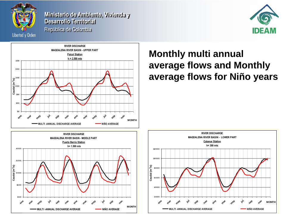
República de Colombia
Monthly multi annual
average flows and Monthly
average flows for Niño years
RIVER DISCHARGE
MAGDALENA RIVER BASIN - UPPER PART
Paicol Station
h = 2.500 mts
50
10 0
150
2 0 0
2 50
3 0 0
3 50
ene
mar
may ju
lse
pnov en
em
arm
ay jul
sep
nov
MONTH
Cau
dal (m
3/s
)
MULTI -ANNUAL DISCHARGE AVERAGE NIÑO AVERAGE
RIVER DISCHARGE
MAGDALENA RIVER BASIN - MIDDLE PART
Puerto Berrío Station
h= 1.500 mts
8 0 0
16 0 0
2 4 0 0
3 2 0 0
4 0 0 0
ene
mar
may ju
lse
pnov en
em
arm
ay jul
sep
nov
MONTH
Cau
dal (m
3/s
)
MULTI -ANNUAL DISCHARGE AVERAGE NIÑO AVERAGE
RIVER DISCHARGE
MAGDALENA RIVER BASIN - LOWER PART
Calamar Station
h= 300 mts
2 0 0 0
4 0 0 0
6 0 0 0
8 0 0 0
10 0 0 0
12 0 0 0
ene
mar
may ju
lse
pnov en
em
arm
ay jul
sep
nov MONTH
Cau
dal (m
3/s
)
MULTI -ANNUAL DISCHARGE AVERAGE NIÑO AVERAGE

Ministerio de Ambiente, Vivienda yDesarrollo Territorial
República de Colombia
Monthly multi annual
average flows and
Monthly average flows
for Niña years
RIVER DISCHARGE
MAGDALENA RIVER BASIN - UPPER PART
Paicol Station
h = 2.500 mts
50
10 0
150
2 0 0
2 50
3 0 0
3 50
ene
mar
may ju
lse
pnov en
em
arm
ay jul
sep
nov MONTH
Cau
dal (m
3/s
)
MULTI -ANNUAL DISCHARGE AVERAGE NIÑA AVERAGE
RIVER DISCHARGE
MAGDALENA RIVER BASIN - MIDDLE PART
Puerto Berrío Station
h = 1.500 mts
12 0 0
2 0 0 0
2 8 0 0
3 6 0 0
ene
mar
may ju
lse
pnov en
em
arm
ay jul
sep
nov MONTH
Cau
dal (m
3/s
)
MULTI -ANNUAL DISCHARGE AVERAGE NIÑA AVERAGE
RIVER DISCHARGE
MAGDALENA RIVER BASIN - LOWER PART
Calamar Station
h = 300 mts
2 0 0 0
4 0 0 0
6 0 0 0
8 0 0 0
10 0 0 0
12 0 0 0
ene
mar
may ju
lse
pnov en
em
arm
ay jul
sep
nov MONTH
Cau
dal (m
3/s
)
MULTI -ANNUAL DISCHARGE AVERAGE NIÑA AVERAGE

Ministerio de Ambiente, Vivienda yDesarrollo Territorial
República de Colombia
Nino event ASO 1976 –
JFM 1977
RIVER DISCHARGE
MAGDALENA RIVER BASIN - UPPER PART
EL NIÑO 1976 - 1977
Paicol Station
50
100
150
200
250
300
350
400
ene
feb
mar ab
r
may ju
n jul
ago
sep
octnov dic
ene
feb
mar ab
r
may ju
n jul
ago
sep
octnov dic MES
Cau
dal (m
3/s
)
1976 -1977 DISCHARGE MULTI -ANNUAL DISCHARGE AVERAGE NIÑO AVERAGE
RIVER DISCHARGE
MAGDALENA RIVER BASIN - MIDDLE PART
EL NIÑO 1976 - 1977
Puerto Berrío Station
500
1500
2500
3500
4500
ene
feb
mar
abr
may ju
nju
lag
ose
poc
tno
vdi
cen
efe
bm
arab
rm
ay jun
jul
ago
sep
oct
nov
dic MES
Cau
dal (m
3/s
)
1976 -1977 DISCHARGE MULTI -ANNUAL DISCHARGE AVERAGE NIÑO AVERAGE
RIVER DISCHARGE
MAGDALENA RIVER BASIN - LOWER PART
EL NIÑO 1976 - 1977
Calamar Station
1500
3000
4500
6000
7500
9000
10500
12000
ene
feb
mar ab
r
may ju
n jul
ago
sep
octnov dic
ene
feb
mar ab
r
may ju
n jul
ago
sep
octnov dic MES
Cau
dal (m
3/s
)
1976 -1977 DISCHARGE MULTI -ANNUAL DISCHARGE AVERAGE NIÑO AVERAGE

Ministerio de Ambiente, Vivienda yDesarrollo Territorial
República de Colombia
Nino event ASO 1977 –
DJF 1978
RIVER DISCHARGE
MAGDALENA RIVER BASIN - UPPER PART
EL NIÑO 1977 - 1978
Paicol Station
50
100
150
200
250
300
350
ene
feb
mar ab
r
may ju
n jul
ago
sep
octnov dic
ene
feb
mar ab
r
may ju
n jul
ago
sep
octnov dic MES
Caudal (m
3/s
)
1977 -1978 DISCHARGE MULTI -ANNUAL DISCHARGE AVERAGE NIÑO AVERAGE
RIVER DISCHARGE
MAGDALENA RIVER BASIN - MIDDLE PART
EL NIÑO 1977 - 1978
Puerto Berrío Station
500
1000
1500
2000
2500
3000
3500
4000
4500
ene
feb
mar ab
r
may ju
n jul
ago
sep
octnov dic
ene
feb
mar ab
r
may ju
n jul
ago
sep
octnov dic
MES
Ca
ud
al (m
3/s
)
1977 -1978 DISCHARGE MULTI -ANNUAL DISCHARGE AVERAGE NIÑO AVERAGE
RIVER DISCHARGE
MAGDALENA RIVER BASIN - LOWER PART
EL NIÑO 1977 - 1978
Calamar Station
1500
3000
4500
6000
7500
9000
10500
12000
ene
feb
mar
abr
may ju
nju
lag
ose
poc
tno
vdi
cen
efe
bm
arab
rm
ay jun
jul
ago
sep
oct
nov
dic MES
Cau
dal (m
3/s
)
1977 -1978 DISCHARGE MULTI -ANNUAL DISCHARGE AVERAGE NIÑO AVERAGE

Ministerio de Ambiente, Vivienda yDesarrollo Territorial
República de Colombia
Niña even ASO 1983
– DJF 1984
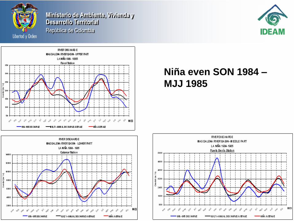
Ministerio de Ambiente, Vivienda yDesarrollo Territorial
República de Colombia
Niña even SON 1984 –
MJJ 1985

Ministerio de Ambiente, Vivienda yDesarrollo Territorial
República de Colombia
LEVELS
ESTACION BARRANCABERMEJA 2001-2007
0,50
1,00
1,50
2,00
2,50
3,00
3,50
4,00
4,50
5,00
5,50
1/1 16/1 31/1 15/2 1/3 16/3 31/3 15/4 30/4 15/5 30/5 14/6 29/6 14/7 29/7 13/8 28/8 12/9 27/9 12/10 27/10 11/11 26/11 11/12 26/12
NIV
EL
(m
)
2001 2002
2003 2004
2005 2006
2007

Ministerio de Ambiente, Vivienda yDesarrollo Territorial
República de Colombia
LEVELS
ESTACION DE EL BANCO 2001-2007
3,00
4,00
5,00
6,00
7,00
8,00
9,00
10,00
1/1 16/1 31/1 15/2 1/3 16/3 31/3 15/4 30/4 15/5 30/5 14/6 29/6 14/7 29/7 13/8 28/8 12/9 27/9 12/10 27/10 11/11 26/11 11/12 26/12
NIVEL (m)
2001 2002 2003 2004 2005 2006 2007

Ministerio de Ambiente, Vivienda yDesarrollo Territorial
República de Colombia
LEVELS
ESTACION CALAMAR 2001-2007
1,00
2,00
3,00
4,00
5,00
6,00
7,00
8,00
9,00
10,00
1/1 16/1 31/1 15/2 1/3 16/3 31/3 15/4 30/4 15/5 30/5 14/6 29/6 14/7 29/7 13/8 28/8 12/9 27/9 12/10 27/10 11/11 26/11 11/12 26/12
NIV
EL
(m
)
2001 2002 2003 2004 2005 2006 2007

Ministerio de Ambiente, Vivienda yDesarrollo Territorial
República de ColombiaConsejo Directivo
Secretaría General
Oficina Asesora
Jurídica
Oficina Asesora
de PlaneaciónOficina de
Control Interno
Oficina del servicio
de pronósticos y
Alertas
Oficina de
Informática
Comité de Coordinación
del Sistema de Control
Interno
Comité de
Personal
Comité
Científico
Subdirección de
Hidrología
Subdirección de
Meteorología
Subdirección de
Ecosistemas e
Información Ambiental
Subdirección de
Estudios Ambientales
Dirección General
Grupo de Archivo Técnico
Grupo de Documentación,
Correspondencia, Archivo y
Orientación al Ciudadano
Grupo de Inventarios y
Almacenes
Grupo de Recursos Físicos
Grupo de Tesorería
Grupo de Contabilidad
Grupo de Recursos
Financieros
Grupo de Administración y
Desarrollo del Talento
Humano
Grupo de Control
Disciplinario Interno
Grupo de Comunicaciones
Cambio Global
Ordenamiento Ambiental
del Territorio
Evaluación Hidrológica
Modelación y Pronósticos
Hidrológicos
Grupo de Monitoreo
Hidrológico
Laboratorio de Calidad
Ambiental del IDEAM
Seguimiento a la
Sostenibilidad del
Desarrollo
Modelamiento numérico del
tiempo y el clima
Climatología y
Agrometeorología
Gestión de Datos y Red
Meteorológica
Bosques
Suelos y Tierras
Sistema de Información
Ambiental Institucional SIA
- IDEAM
Meteorología aeronáutica
27 aeropuertos
Operación de Redes
11 Áreas OperativasAcreditación de
Laboratorios
INSUMOS PARA
PREVENCIÓN Y
REDUCCIÓN DE
RIESGOS
(ALERTAS
TEMPRANAS)
FORECASTING AND WARNING OFFICE

Ministerio de Ambiente, Vivienda yDesarrollo Territorial
República de Colombia
NATURAL ANTRÓPICA
Volcánica Peligros tecnológicos
Sísmica
Tsunamis
Meteorológicas
Hidrológicas
Climáticas
TYPES OF HAZARD
IDEAM
To provide forecasts and warmings to prevent
loss of life and reducing negative impacts of
hydrometeorological hazard and climate

Ministerio de Ambiente, Vivienda yDesarrollo Territorial
República de Colombia
Slow Flood
Flash Flood
Landslides
Fire forest
Hurricanes
HYDROMETEOROLOGICAL HAZARD

Ministerio de Ambiente, Vivienda yDesarrollo Territorial
República de Colombia
Red pluviométrica, climatológica ehidrológica.
Red de sondeo de la atmósfera
Red de alertas hidrológicas
Red especial de monitoreo de lluvia ytemperaturas extremas.
Red Seguimiento de Huracanes
Red mareográfica
Red agrometeorológica
REDES NACIONALES E INTERNACIONALES DE ALERTA PARA DISMINUIR LA
VULNERABILIDAD.

Ministerio de Ambiente, Vivienda yDesarrollo Territorial
República de Colombia
SISTEMA NACIONAL DE MEDICIONES Y OBSERVACIONESCompuesto por:
Red de estaciones de superficie continental. (Convencionales y Automáticas)
Estaciones en el sector insular.
Red de estaciones de altura.
Imágenes de satélite.
Información proveniente de centros internacionales.
ESTACIONES
2.134 ESTACIONES CONVENCIONALES
782 ESTACIONES HIDROLOGICAS
500 ESTACIONES METEOROLOGICAS
1298 PLUVIOMETRICAS
446 ESTACIONES AUTOMATICAS
216 AUTOMATICAS SIN TRANSMISION
SATELITAL
230 CON TRANSMISIÓN SATELITAL

Ministerio de Ambiente, Vivienda yDesarrollo Territorial
República de Colombia
MESA DE TRABAJO * Oficina del Servicio de Pronóstico y Alertas

Ministerio de Ambiente, Vivienda yDesarrollo Territorial
República de Colombia
BOLETÍN
AVISO
ALERTA
COMUNICADOS
ESPECIALES
Usuarios con prioridad
Presidencia de la República
Dirección de Gestión del
Riesgo-DGR
Comités regionales y locales
de Prevención y Atención de
Desastres Crepads y
Clopads
Defensa Civil
Cruz Roja
Crecientes súbitas
Crecientes lentas
Deslizamientos por lluvias
Heladas
Incendios forestales
Sequías (El NIÑO)
Lluvias intensas (La Niña)
Huracanes
Altas y bajas temperaturas
ALERTAS MEDIOAMBIENTALES

Ministerio de Ambiente, Vivienda yDesarrollo Territorial
República de Colombia
COMITÉS TÉCNICOS DE PRONÓSTICO, PREDICCIÓN
CLIMÁTICA Y SEGUIMIENTO FENOMENOS “ EL NIÑO Y LA
NIÑA”

Ministerio de Ambiente, Vivienda yDesarrollo Territorial
República de Colombia FORECASTING AND WARNING
WEB PAGE

Ministerio de Ambiente, Vivienda yDesarrollo Territorial
República de Colombia
1. Tiempo real
3. Alertas, boletines y
Avisos
2. Pronóstico
DAILY UPDATE WEB PAGE
Ministerio de Ambiente, Vivienda yDesarrollo Territorial
República de Colombia
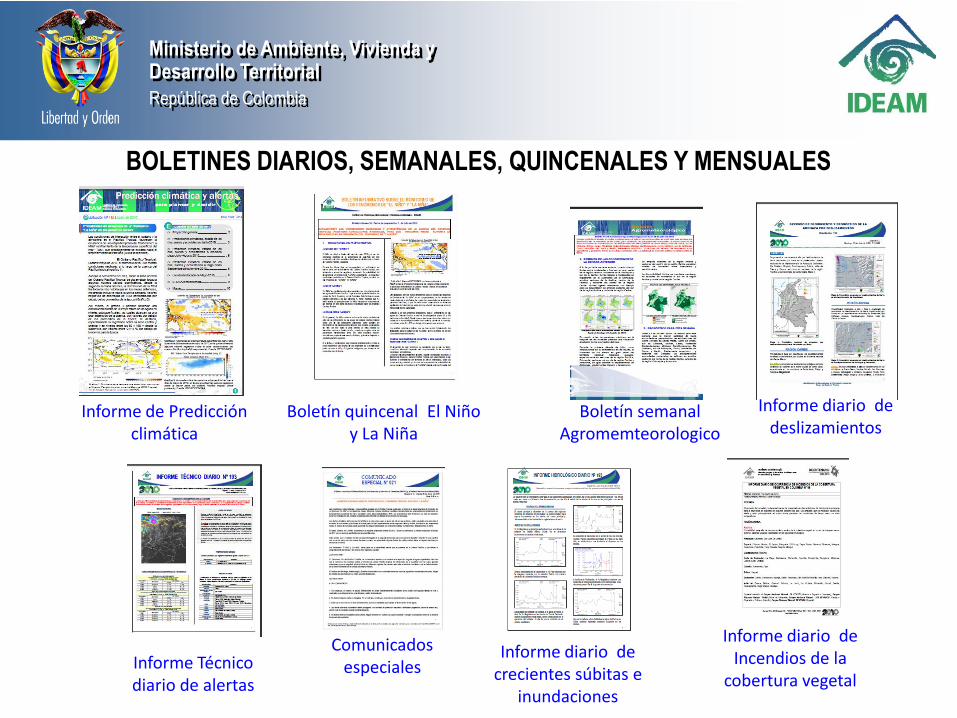
Boletín quincenal El Niño y La Niña
Boletín semanal Agromemteorologico
Informe diario de deslizamientos
Informe diario de Incendios de la
cobertura vegetal
Informe diario de crecientes súbitas e
inundaciones
Comunicados especialesInforme Técnico
diario de alertas
Informe de Predicción climática
BOLETINES DIARIOS, SEMANALES, QUINCENALES Y MENSUALES

Ministerio de Ambiente, Vivienda yDesarrollo Territorial
República de Colombia
IDEAM - Oficina del Servicio de Pronósticos y Alertas
EL BANCO - RIO MAGDALENA - COTA CRITICA 8.30 mts - 7.05 mts
(Belén - Ciénaga Zapatosa - Nivel de reducción 3.65 mts
3,00
3,50
4,00
4,50
5,00
5,50
6,00
6,50
7,00
7,50
8,00
8,50
abr may jun jul ago sep
Niveles (mts)
MED MAXMIN El BancoCOTA DE INUNDACION MINIMO ABSOLUTO 1998
.
Seguimiento niveles de los ríos
Ministerio de Ambiente, Vivienda yDesarrollo Territorial
República de Colombia

Ministerio de Ambiente, Vivienda yDesarrollo Territorial
República de Colombia
Sector: Puerto Salgar – Barrancabermeja
250 Kms-secciones transversales cada 2 kms)
MODELACIÓN RÍO MAGDALENA CON EL MIKE 11

Ministerio de Ambiente, Vivienda yDesarrollo Territorial
República de Colombia

Ministerio de Ambiente, Vivienda yDesarrollo Territorial
República de ColombiaHYDROLOGIC DAILY REPORT
Las líneas punteadas sobre la gráfica indican periodos en los cuales se ha bajado información del Thalimedes al VOTA

Ministerio de Ambiente, Vivienda yDesarrollo Territorial
República de Colombia IMPROVING SKILLS ABOUT:
- To standardizing data formats (i.e. matlab, etc.) for using them in the computer tools (i.e CPT)

Ministerio de Ambiente, Vivienda yDesarrollo Territorial
República de Colombia
Data coming from: LNM, LG, RAN

Ministerio de Ambiente, Vivienda yDesarrollo Territorial
República de Colombia
- To interpretation of data

Ministerio de Ambiente, Vivienda yDesarrollo Territorial
República de Colombia
THANKS
http://www.ideam.gov.co