morphometric analysis of the manas river basin … analysis of the manas river basin using earth...
TRANSCRIPT
INTERNATIONAL JOURNAL OF GEOMATICS AND GEOSCIENCES
Volume 2, No 2, 2011
© Copyright 2010 All rights reserved Integrated Publishing services
Research article ISSN 0976 – 4380
Submitted on Octoner 2011 published on November 2011 647
Morphometric analysis of the Manas river basin using earth observation
data and Geographical Information System Jenita Mary Nongkynrih
1, Zahid Husain
2
1- North Eastern Space Applications Centre, Govt. of India, Dept. of Space, Umiam-793103
(Meghalaya), India
2- Department of Geography, North Eastern Hill University, Shillong-793022(Meghalaya),
India
ABSTRACT
Basin morphometry is a means of numerically analysing or mathematically quantifying
different aspects of a drainage basin. In the present study, morphometric analysis of the
Manas drainage basin has been carried using earth observation data and geographical
information system (GIS) techniques. The morphometric parameters considered for analysis
includes the linear, areal and relief aspects of the basin. The Manas basin covers an area of
31,480 sq km and is an 8th
order drainage basin with mainly dendritic drainage pattern. The
mean bifurcation ratio is 3.81 indicating the basin is largely controlled by structure. The basin
has medium drainage density of 0.78 per km2
and is elongated in shape. The length of
overland flow values of the basin is 0.64, indicating high relief. The study has strengthened in
understanding the hydrological, geological and geomorphological characteristics of the
Manas drainage basin.
Keywords: Morphometry, Manas river basin, earth observation data, geographical
information system
1. Introduction
Morphometry is an essential means in geomorphic analysis of an area. Morphometry is
defined as the measurement and mathematical analysis of the configuration of the earth’s
surface and of the shape and dimension of its landforms (Clarke, 1966). Morphometric
methods, though simple, have been applied for the analysis of area-height relationships,
determination of erosion surfaces, slopes, relative relief and terrain characteristics as a whole.
The morphometric analyses of different basins have been done by various scientists using
conventional methods (Horton, 1945; Smith, 1950; Strahler, 1957) and earth observation data
and GIS methods (Narendra and Rao, 2000, ). The use of earth observation data and GIS
techniques in morphometric analysis have emerged as powerful tools in recent years
particularly for remote areas. In the present study using Earth Observation Data and GIS
technology have been effectively used to compute basin morphometric characteristics by
taking linear, areal and relief parameters of the Manas river basin. Such analysis aided in
understanding the hydrological, geological and topographical characteristics of the very
complicated and unique Manas drainage basin.
The Manas River is the largest Himalayan tributary of the mighty Brahmaputra. The Manas
River System (26010′ to 26
050′N Latitudes and 90
0 00′ to 91
000′E Longitudes) along with its
tributaries is one of the biggest river systems meeting the Brahmaputra River from the north
bank in Assam. The approximate area of the Manas River System is 31,480 sq km. The
Morphometric analysis of the Manas river basin using earth observation data and Geographical Information
System
Jenita Mary Nongkynrih, Zahid Husain
International Journal of Geomatics and Geosciences
Volume 2 Issue 2, 2011 648
length of the Manas River flows is about 106.75 km in Tibet, 201.73 km in the Bhutan
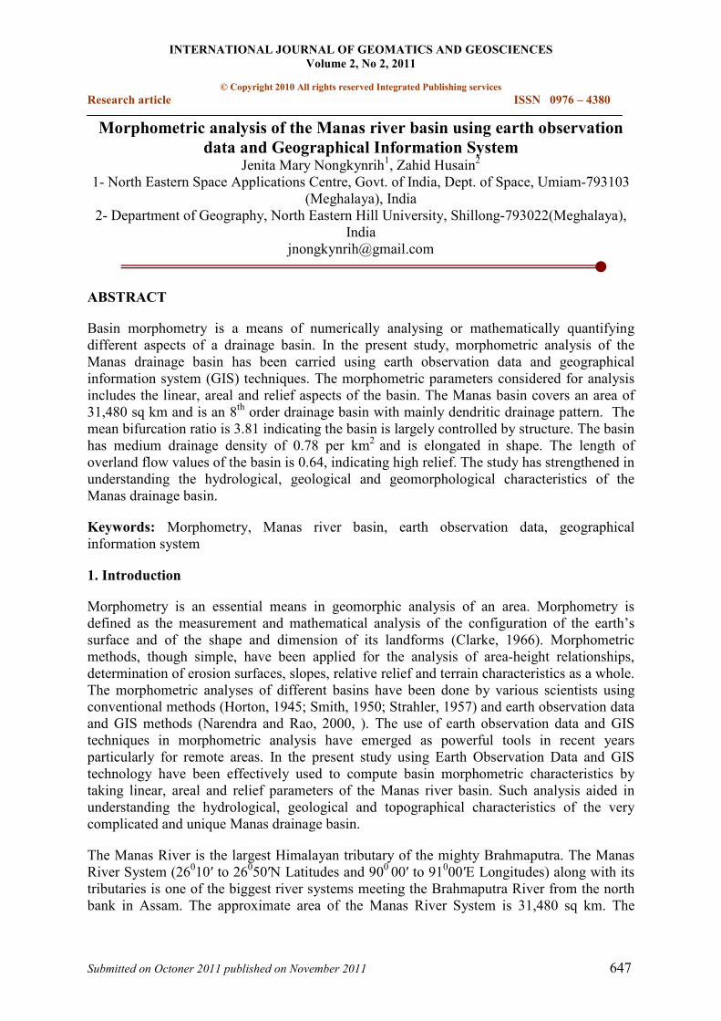
Himalaya and 75.30 km in Assam valley before meeting the Brahmaputra (Figure 1).
Figure 1: The Manas River Basin
2. Materials and Method
Delineation of the Manas river basin and preparation of drainage map is based on geo-coded
Resourcesat-1 LISS-III of 2005-06 on 1:50,000 scale and Digital Elevation Model (DEM)
generated from Shuttle Radar Terrain Mapper (SRTM) data. Various morphometric
parameters namely – stream order (Nu), stream length (Lu), mean stream length (Lsm), stream
length ratio (RL), bifurcation ratio (Rb) mean bifurcation ratio (Rbm), drainage density (D),
stream frequency (Fs), form factor (Rf), circulatory ratio (Rc), elongation ratio (Re) length of
overland flow (Lg) have been computed (Table 1) using GIS tools.
3. Results and Discussions
The various morphometric parameters of the Manas river basin have been computed and
summarized as follows:
3.1 Linear aspects
Drainage network of the Manas River basin is presented in Figure 1. Stream links (the
different drainage lines) and the nodes (the stream junctions/confluences) characterise ‘Linear
aspects’ of the basin. The linear aspects include the stream order (u), stream length (Lu),
mean stream length (Lsm), stream length ratio (RL) and bifurcation ratio (Rb), were
determined and results have been presented in Table 2.
3.1.1 Stream order (u)
Morphometric analysis of the Manas river basin using earth observation data and Geographical Information
System
Jenita Mary Nongkynrih, Zahid Husain
International Journal of Geomatics and Geosciences
Volume 2 Issue 2, 2011 649
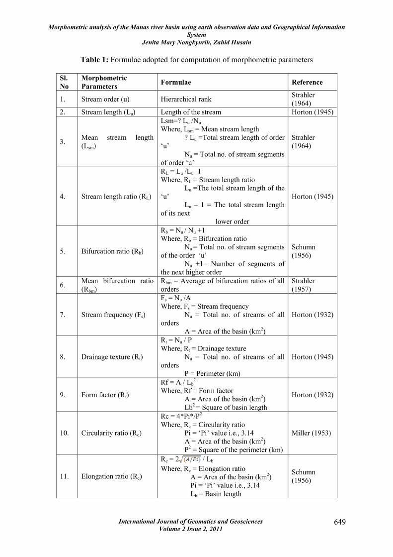
Table 1: Formulae adopted for computation of morphometric parameters
Sl.
No
Morphometric
Parameters Formulae Reference
1. Stream order (u) Hierarchical rank Strahler
(1964)
2. Stream length (Lu) Length of the stream Horton (1945)
3. Mean stream length
(Lsm)
Lsm=? Lu /Nu
Where, Lsm = Mean stream length
? Lu =Total stream length of order
‘u’
Nu = Total no. of stream segments
of order ‘u’
Strahler
(1964)
4. Stream length ratio (RL)
RL = Lu /Lu -1
Where, RL = Stream length ratio
Lu =The total stream length of the
‘u’
Lu – 1 = The total stream length
of its next
lower order
Horton (1945)
5. Bifurcation ratio (Rb)
Rb = Nu / Nu +1
Where, Rb = Bifurcation ratio
Nu = Total no. of stream segments
of the order ‘u’
Nu +1= Number of segments of
the next higher order
Schumn
(1956)
6. Mean bifurcation ratio
(Rbm)
Rbm = Average of bifurcation ratios of all
orders
Strahler
(1957)
7. Stream frequency (Fs)
Fs = Nu /A
Where, Fs = Stream frequency
Nu = Total no. of streams of all
orders
A = Area of the basin (km2)
Horton (1932)
8. Drainage texture (Rt)
Rt = Nu / P
Where, Rt = Drainage texture
Nu = Total no. of streams of all
orders
P = Perimeter (km)
Horton (1945)
9. Form factor (Rf)
Rf = A / Lb2
Where, Rf = Form factor
A = Area of the basin (km2)
Lb2 = Square of basin length
Horton (1932)
10. Circularity ratio (Rc)
Rc = 4*Pi*/P2
Where, Rc = Circularity ratio
Pi = ‘Pi’ value i.e., 3.14
A = Area of the basin (km2)
P2 = Square of the perimeter (km)
Miller (1953)
11. Elongation ratio (Re)
Re = 2 / Lb
Where, Re = Elongation ratio
A = Area of the basin (km2)
Pi = ‘Pi’ value i.e., 3.14
Lb = Basin length
Schumn
(1956)
Morphometric analysis of the Manas river basin using earth observation data and Geographical Information
System
Jenita Mary Nongkynrih, Zahid Husain
International Journal of Geomatics and Geosciences
Volume 2 Issue 2, 2011 650
12. Length of overland flow
(Lg)
Lg = 1 / D*2
Where, Lg = Length of overland flow
D = Drainage density
Horton (1945)
Ranking of streams has been carried out based on the method proposed by Strahler (1964).
The smallest fingertip tributaries are designated as order 1. Where the two first-order
channels join, a channel segment of 2nd
order is formed and so forth. The trunk stream
through which all discharge and sediments pass is therefore the stream segment of the highest
order. It has been found that the study area is an 8th
order drainage basin. Altogether, 15482
number of streams were identified, out of which 12121 are of 1st order, 2537are of 2
nd order,
621 are of 3rd
order, 163 are of 4th
order, 29 are of 5th
order, 5 are of 6th
order, 3 are of 7th
order and 3 are of 8th
order streams. Dendritic drainage pattern is seen in the hilly and plateau
parts of the drainage basin indicating the homogeneity in texture and lack of structural control.
However, the piedmont zone of the basin is characterized by branching drainage pattern.
Interestingly, the confluence of the Manas with the Brahmaputra River represents ‘yazoo’
pattern in which the tributary flows for some distance along the master stream or before the
confluence.
3.1.2 Stream length (Lu)
Stream length is measured from the farthest drainage divide to the mouth of a river, based on
the law proposed by Horton (1945). Stream length is one of the significant features of the
basin as it reveals surface run-off characteristics. Streams of relatively smaller lengths
indicate that the area is with high slopes. Longer lengths are indicative of flatter gradient.
Usually, the total length of stream segments is highest in first order streams, and it decreases
as the stream order increases in the present case. This brings out strong assumption that the
basin is subjected to erosion and also that some areas of the basin are characterized by
variation in lithology and topography (Singh and Singh, 1997; Vittala et al., 2004 and Chopra
et al., 2005).
3.1.3 Mean stream length (Lsm)
Mean stream length (Lsm) is a characteristic property related to the drainage network
components and its associated basin surfaces (Strahler, 1964). This has been calculated by
dividing the total stream length of order (u) by the number of streams of segments in that
order (Table 2). It is seen that Lsm values exhibit variation from 1.28 to 43.72. This deviation
might be due to change in topographic elevation and slope of the basin.
3.1.4 Stream length ratio (RL)
Stream length ratio (RL) is the ratio of the mean length of the one order to the next order of
the stream segments. Total stream length of a given order is inversely related to stream order,
i.e., total stream length decreases from the lower order to the successively higher orders. This
change might be attributed to variation in slope and topography, indicating the youth stage of
geomorphic development in the streams of the study area (Singh and Singh, 1997 and Vittala
et al., 2004).
3.1.5 Bifurcation ratio (Rb)
According to Schumm (1956), the term bifurcation ratio may be defined as the ratio of the
number of the stream segments of given order to the number of segments of the next higher
Morphometric analysis of the Manas river basin using earth observation data and Geographical Information
System
Jenita Mary Nongkynrih, Zahid Husain
International Journal of Geomatics and Geosciences
Volume 2 Issue 2, 2011 651
orders. Bifurcation ratio shows a small range of variation for different regions or for different
environments except where the powerful geological control dominates (Strahler, 1957). The
Rb values of study area (Table 2) indicate that there is a uniform decrease in Rb values from
the first order streams to the fourth order streams. But an increase in the Rb values is
noticeable from the fourth to sixth order streams. The Rb values then suddenly decrease from
the sixth to the eighth order. These differences are depending upon the geological and
lithological development of the drainage basin (Strahler, 1964). In the study area, the higher
values of Rb indicate a strong structural control in the drainage development whereas the
lower values indicate that some of the area in the basin is less affected by structural
disturbances (Stahler, 1964; Nag, 1998; Vittala et al., 2004 and Chopra et al., 2005). The Rb
values in the study area range from 1.00 to 5.80 indicating that the basin is largely controlled
by structure (Strahler, 1957).
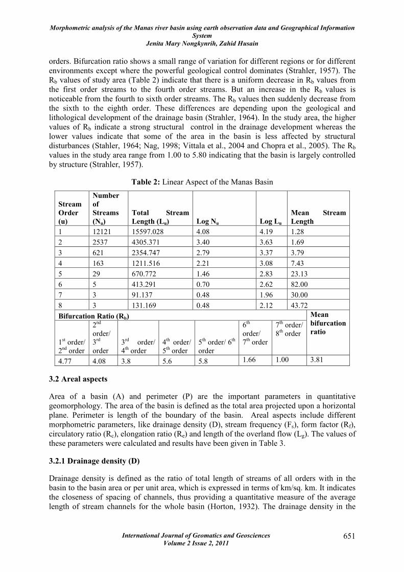
Table 2: Linear Aspect of the Manas Basin
Stream
Order
(u)
Number
of
Streams
(Nu)
Total Stream
Length (Lu) Log Nu Log Lu
Mean Stream
Length
1 12121 15597.028 4.08 4.19 1.28
2 2537 4305.371 3.40 3.63 1.69
3 621 2354.747 2.79 3.37 3.79
4 163 1211.516 2.21 3.08 7.43
5 29 670.772 1.46 2.83 23.13
6 5 413.291 0.70 2.62 82.00
7 3 91.137 0.48 1.96 30.00
8 3 131.169 0.48 2.12 43.72
Bifurcation Ratio (Rb)
1st order/
2nd
order
2nd
order/
3rd
order
3rd
order/
4th order
4th order/
5th order
5th order/ 6
th
order
6th
order/
7th order
7th order/
8th order
Mean
bifurcation
ratio
4.77 4.08 3.8 5.6 5.8 1.66 1.00 3.81
3.2 Areal aspects
Area of a basin (A) and perimeter (P) are the important parameters in quantitative
geomorphology. The area of the basin is defined as the total area projected upon a horizontal
plane. Perimeter is length of the boundary of the basin. Areal aspects include different
morphometric parameters, like drainage density (D), stream frequency (Fs), form factor (Rf),
circulatory ratio (Rc), elongation ratio (Re) and length of the overland flow (Lg). The values of
these parameters were calculated and results have been given in Table 3.
3.2.1 Drainage density (D)
Drainage density is defined as the ratio of total length of streams of all orders with in the
basin to the basin area or per unit area, which is expressed in terms of km/sq. km. It indicates
the closeness of spacing of channels, thus providing a quantitative measure of the average
length of stream channels for the whole basin (Horton, 1932). The drainage density in the
Morphometric analysis of the Manas river basin using earth observation data and Geographical Information
System
Jenita Mary Nongkynrih, Zahid Husain
International Journal of Geomatics and Geosciences
Volume 2 Issue 2, 2011 652
basin is 0.78 per km2
i.e., medium drainage density indicating that the basin has permeable
rocks.
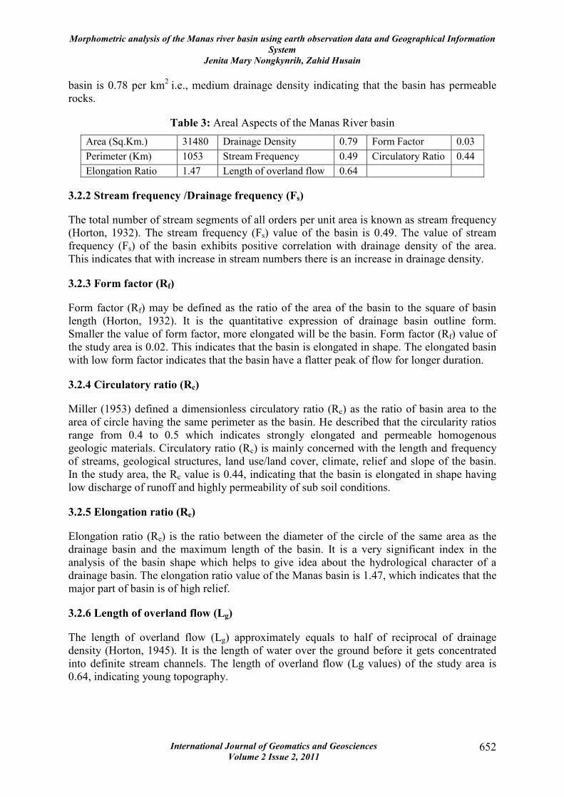
Table 3: Areal Aspects of the Manas River basin
Area (Sq.Km.) 31480 Drainage Density 0.79 Form Factor 0.03
Perimeter (Km) 1053 Stream Frequency 0.49 Circulatory Ratio 0.44
Elongation Ratio 1.47 Length of overland flow 0.64
3.2.2 Stream frequency /Drainage frequency (Fs)
The total number of stream segments of all orders per unit area is known as stream frequency
(Horton, 1932). The stream frequency (Fs) value of the basin is 0.49. The value of stream
frequency (Fs) of the basin exhibits positive correlation with drainage density of the area.
This indicates that with increase in stream numbers there is an increase in drainage density.
3.2.3 Form factor (Rf)
Form factor (Rf) may be defined as the ratio of the area of the basin to the square of basin
length (Horton, 1932). It is the quantitative expression of drainage basin outline form.
Smaller the value of form factor, more elongated will be the basin. Form factor (Rf) value of
the study area is 0.02. This indicates that the basin is elongated in shape. The elongated basin
with low form factor indicates that the basin have a flatter peak of flow for longer duration.
3.2.4 Circulatory ratio (Rc)
Miller (1953) defined a dimensionless circulatory ratio (Rc) as the ratio of basin area to the
area of circle having the same perimeter as the basin. He described that the circularity ratios
range from 0.4 to 0.5 which indicates strongly elongated and permeable homogenous
geologic materials. Circulatory ratio (Rc) is mainly concerned with the length and frequency
of streams, geological structures, land use/land cover, climate, relief and slope of the basin.
In the study area, the Rc value is 0.44, indicating that the basin is elongated in shape having
low discharge of runoff and highly permeability of sub soil conditions.
3.2.5 Elongation ratio (Re)
Elongation ratio (Re) is the ratio between the diameter of the circle of the same area as the
drainage basin and the maximum length of the basin. It is a very significant index in the
analysis of the basin shape which helps to give idea about the hydrological character of a
drainage basin. The elongation ratio value of the Manas basin is 1.47, which indicates that the
major part of basin is of high relief.
3.2.6 Length of overland flow (Lg)
The length of overland flow (Lg) approximately equals to half of reciprocal of drainage
density (Horton, 1945). It is the length of water over the ground before it gets concentrated
into definite stream channels. The length of overland flow (Lg values) of the study area is
0.64, indicating young topography.
Morphometric analysis of the Manas river basin using earth observation data and Geographical Information
System
Jenita Mary Nongkynrih, Zahid Husain
International Journal of Geomatics and Geosciences
Volume 2 Issue 2, 2011 653
3.3 Relief Aspects
Relief aspects of drainage basin relate to the three dimensional features of the basin involving
area, volume and altitude of vertical dimension of landforms wherein different morphometric
methods are used to analyse terrain characteristics. In this study, thus, relief aspect includes
the analysis of average slope, relative reliefs, etc.
3.3.1 Average Slope
Slope is defined as the angular inclination of terrain between hill-tops and valley bottoms.
Slope angle in degree of the drainage basin are tabulated and classified into convenient slope
categories viz., (i) level slope = 00–10
0, (ii) gentle slope = 10
0–22
0, (iii) moderate slope = 22
0
– 300, (v) steep slope = 33
0 – 43
0 SS, and (vi) very steep slope = above 43
0 .
3.3.2 Relative Relief
Relative relief termed as ‘amplitude of available relief’ or ‘local relief’ is defined as the
difference in height between the highest and the lowest points (height) in a unit area. It is an
important morphometric variable used for the overall assessment of morphological
characteristics of terrain. Melton (1958) suggested to calculate relative relief by dividing the
difference of height between the highest and lowest points in the basin (H) with basin
perimeter (P), thus relative relief = H/P. Relative relief is calculated on the basis of highest
and lowest elevations and the data of relative relief so derived are tabulated and classified
into three categories viz. (i) low relative relief = 0m – 100m, (ii) moderately relative relief
100m – 300 m and (iii) high relative relief = above 300m.
4. Conclusions and Findings
The morphometric analysis has been carried out through measurement of linear, areal and
relief aspects of basins. It has been found that the study area is an 8th
order drainage basin.
Dendritic drainage pattern is seen in the hilly and plateau parts of the drainage basin
indicating the homogeneity in texture and lack of structural control. However, the piedmont
zone of the basin is characterised by branching drainage pattern which is characterised by the
Siwaliks deposits.
From the study it can be concluded that areas drained by drainage orders of 1st, 2
nd, 3
rd, 7
th
and 8th
have Bifurcation ratio between 3.0 to 5.0, indicating that these are not distorted by
geological structures. The Bifurcation ratio in case of the 4th
to the 6th
drainage orders, it is
more than 5.0. It is noted that, in the drainage basin that these areas are dominated by the
presence of lineaments. The presence of the maximum number of the first order segments
shows that the basin is subjected to erosion and also that some areas of the basin are
characterised by variations in lithology and topography The deviation of the mean stream
length values from 1.28 to 43.72 clearly indicates the change in topographic elevation and
slope of the Manas basin. The elongation ratio value of the Manas basin is 1.47, which
indicates that the major part of basin is of high relief. The length of overland flow (Lg values)
of the study area is 0.64, indicating young topography. The slope of the basin ranges from a
level slope in the plains (southern part) to a very steep slope in the northern part of the basin.
Low relief to moderately relief is in the plains and high relative relief is in the hilly area.
Morphometric analysis of the Manas river basin using earth observation data and Geographical Information
System
Jenita Mary Nongkynrih, Zahid Husain
International Journal of Geomatics and Geosciences
Volume 2 Issue 2, 2011 654
Acknowledgements
We are thankful to the Director, North Eastern Space Applications Centre, Umiam for giving
us the opportunity to work in this project.
5. References
1. Chopra, R., Dhiman, R. D., Sharma P. K (2005), Morphometric analysis of sub-
watersheds in Gurudaspur district, Punjab using Remote sensing and GIS techniques,
Journal of Indian Socciety of Remote Sensing, 33(4), pp 531–539.
2. Clarke, J.I (1966), Morphometry from maps, in: Dury, G.H. (Ed), Essays in
Geomorphology, American Elsevier Publ. Co., New York, pp 235–274.
3. Horton R.E (1932), Drainage basin characteristics, Transactions- American
Geophysical Union, 13, pp 350–361.
4. Horton R.E (1945), Erosional development of streams and their drainage basins;
Hydro physical approach to quantitative morphology, Geological Society of America
Bulletin, 56(3), pp 275–370.
5. Melton, M.A (1958), Geometric properties of mature drainage basin systems and their
representation in their E4 phase space, Journal of Geology, 66, pp 35-56.
6. Miller, V.C (1953), A quantitative geomorphic study of drainage basin characteristics
in Clinch mountain area, Virginia and Tennesse, Project NR 389-042, Technical
Report:3, Columbia University, Department of Geology, ONR, Geography branch,
New York. Nag, S.K., Chakraborty, S., 2003, Influences of rock types and structures
in the development of drainage network in hard rock area, Journal of Indian Society
Remote Sensing, 31(1), pp. 25–35.
7. Schumn, S.A (1956), Evolution of drainage systems and slopes in Badlands at Perth
Amboy. New Jersey. Geological Society of America Bulletin, 67, pp 597–646.
8. Singh, S., Singh, M.C (1997), Morphometric analysis of Kanhar river basin. National
Geographical Journal of India. 43(1), pp 31–43.
9. Smith, K.G (1950), Standards for grading textures of erosional topography. American
Journal of Science, 248(9), pp 655–668.
10. Strahler, A.N (1957), Watershed geomorphology. Transactions- American
Geophysical Union, 38(6), 913–920.
11. Strahler, A. N (1964), Quantitative geomorphology of drainage basins and channel
networks, in: Chow, V. T. (ed.). Handbook of Applied Hydrology. McGraw-Hill,
New York. pp. 439-476.
12. Vittala S.S., Govindaiah S., and Honne G., H (2004), Morphometric analysis of sub-
watersheds in the Pawagada area of Tumkur district, South India, using remote
sensing and GIS techniques. Journal Indian Society of Remote Sensing, 32(4), pp
351–362.