mount peake project - tngltd.com.au · mount peake project authorisation 0908-01 ... 5.7...
TRANSCRIPT

NORTHERN TERRITORY DEPARTMENT OF PRIMARY INDUSTRY
AND RESOURCES
MINING MANAGEMENT PLAN (MMP) FOR
EXPLORATION OPERATIONS
MOUNT PEAKE PROJECT
AUTHORISATION 0908-01
Enigma Mining Limited
December 2017
Compiled by Reviewed by Approved by
Date December 2017 December 2017 December 2017
Name Cath Wetherley Kim Grey Paul Burton
Signature
I Paul Burton (Managing Director) declare that to the best of my knowledge the information contained in this mining management plan is true and correct and commit to undertake the works detailed in this plan in accordance with all the relevant Local, Northern Territory and Commonwealth Government legislation.
SIGNATURE:
DATE: 18/12/17
Document Distribution: Enigma Mining Limited
Department of Primary Industry and Resources
Central Land Council

Enigma Mining Limited Mount Peake Exploration Management Plan 2017
Page 2 of 39
CONTENTS
AMENDMENTS ..................................................................................................................................................... 4
1.0 OPERATOR DETAILS .................................................................................................................................. 5
1.1 TNG ORGANISATIONAL STRUCTURE ................................................................................................ 5
1.2 WORKFORCE ........................................................................................................................................ 5
2.0 IDENTIFIED STAKEHOLDERS .................................................................................................................... 6
3.0 PROJECT DETAILS ...................................................................................................................................... 6
3.1 PREVIOUS ACTIVITIES AND CURRENT STATUS ............................................................................... 8
3.2 PROPOSED ACTIVITIES IN 2017-2018 .............................................................................................. 16
4.0 CURRENT PROJECT SITE CONDITIONS ................................................................................................. 17
4.1 GEOLOGY ............................................................................................................................................ 17
4.2 HYDROLOGY ....................................................................................................................................... 18
4.3 FLORA AND FAUNA ............................................................................................................................ 20
4.4 CURRENT LAND USE .......................................................................................................................... 23
4.5 HISTORICAL, ABORIGINAL, HERITAGE SITE ................................................................................... 23
5.0 ENVIRONMENTAL MANAGEMENT SYSTEM / PLAN.............................................................................. 24
5.1 ENVIRONMENTAL POLICY AND RESPONSIBILITIES ...................................................................... 24
5.2 STATUTORY AND NON-STATUTORY REQUIREMENTS .................................................................. 24
5.3 INDUCTION AND TRAINING ............................................................................................................... 25
5.4 IDENTIFICATION OF ENVIRONMENTAL ASPECTS AND IMPACTS ................................................ 26
5.5 ENVIRONMENTAL AUDITS, INSPECTIONS AND MONITORING ...................................................... 29
5.6 ENVIRONMENTAL PERFORMANCE .................................................................................................. 32
5.7 ENVIRONMENTAL EMERGENCY PROCEDURES AND INCIDENT REPORTING ............................ 33
6.0 EXPLORATION REHABILITATION............................................................................................................ 36
6.1 EXPLORATION REHABILITATION REGISTER .................................................................................. 37
6.2 COSTING OF CLOSURE ACTIVITIES ................................................................................................ 37
7.0 APPENDICES .............................................................................................................................................. 39
FIGURES
Figure 1: Mount Peake Project Area – Location and Cadastral Boundaries. ......................................................... 7
Figure 2: Mount Peake Project Area – Details of Exploration. .............................................................................. 11
Figure 3: Location of all Drilled Waterbores. ......................................................................................................... 14
Figure 4: Tracks and Campsites Cleared During the 2015/16 Waterbore Drilling. ............................................... 15
Figure 5: Hydrology – Water Bore and Aquifer Locations..................................................................................... 19
Enigma Mining Limited Mount Peake Exploration Management Plan 2017
Page 3 of 39
APPENDICES
APPENDIX 1 – LANDHOLDER APPROVAL
APPENDIX 2 – DRILLHOLE LOCATIONS
APPENDIX 3 – WATERBORE DRILLHOLE REHABILITATION PHOTOGRAPHS
APPENDIX 4 – MONITORING STATION PHOTOGRAPHS
APPENDIX 5– ENVIRONMENTAL MANAGEMENT GUIDELINES
APPENDIX 6 – ENVIRONMENTAL POLICY
APPENDIX 7 – ACCIDENT/INCIDENT FORM
APPENDIX 8 – MOUNT PEAKE REHABILITATION CHECKLIST
APPENDIX 9 – MOUNT PEAKE REHABILITATION REGISTER
APPENDIX 10 – MOUNT PEAKE SECURITY CALCULATION SPREADSHEET

Enigma Mining Limited Mount Peake Exploration Management Plan 2017
Page 4 of 39
AMENDMENTS
Section Amendment
3.0 Project Details Added EL 31389 to the Mining Interests and Figure 1 updated.
3.1 Previous Activities and Current Status
Figure 2 updated with new tenure.
TNG 2016 and TNG 2017 Exploration updated along with associated figures.
4.3 Flora and Fauna Updated based on EIS submissions.
5.5.1 Environmental Audits Audit schedule section and Table 7 updated.
5.5.2 Site Monitoring Drill site and access track monitoring, Campsite monitoring and Table 8 and 9 updated.
5.6.2 Performance Reporting Content updated.
5.7.2 Incident Reporting Updated as per Comment on MMP – Mount Peake Project – November 2016.
6.2 Costing of Closure Activities Security Summary Table added.
7.0 APPENDICES Appendix 2 removed and attached separately.

Enigma Mining Limited Mount Peake Exploration Management Plan 2017
Page 5 of 39
1.0 OPERATOR DETAILS
Operator Name: Enigma Mining Limited (ACN: 009 225 558) a wholly owned subsidiary of TNG Ltd. (ACN: 000 817 023) a company Listed on the Australian Stock Exchange (ASX).
Key Contact Person/s: Paul Burton
Postal Address: PO BOX 1126, SUBIACO, WA, 6904
Street Address: Level 1, 282 Rokeby Road, SUBIACO, WA, 6008
Phone: +61 8 9327 0900
Fax: +61 8 9327 0901
Email: [email protected]
Enigma Mining Limited is a wholly owned subsidiary of TNG Limited. Throughout this report the company will be referred to as TNG.
1.1 TNG ORGANISATIONAL STRUCTURE
1.2 WORKFORCE
1 Exploration Manager
1 Exploration Geologist
1 Senior Field Technician
1 Field Assistant

Enigma Mining Limited Mount Peake Exploration Management Plan 2017
Page 6 of 39
2.0 IDENTIFIED STAKEHOLDERS
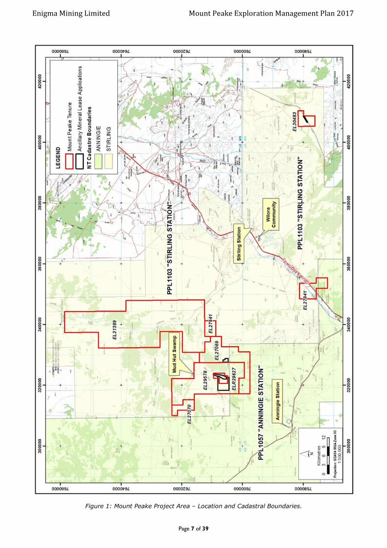
Parts of the following NT Portions are affected by the granted EL’s (Figure 1):
EL29578, EL27069, EL27070, EL27941, ELR29627, EL30483: NT Portion 655, PPL1103 “Stirling Station” – Stirling Station Pty Ltd. Matthew McCarthy.
EL29578, EL27069 and EL27070 and EL27941: NT Portion 362, PPL1057 “Anningie Station” – Davmax
Pty Ltd. Steven Fogarty. Other stakeholders consulted with:
Traditional Landowners
Central Land Council (CLC), Native Title Representative Body for the region.
Aboriginal Areas Protection Authority (AAPA).
Department of Primary Industry and Resources (DPIR).
TNG Limited (TNG) promotes its exploration programs to all known and affected stakeholders prior to any exploration work being carried out to avoid or minimise disruption to the daily routines of the pastoralist activities and to have input into the exploration process if they see it necessary.
All statutory stakeholder notifications and newspaper advertisements are submitted with the exploration licence applications. Before field exploration commences each of the station owners/managers affected by exploration are notified and consulted with. Station owners are visited prior to exploration activities commencing and accommodation will often be arranged onsite at the station homestead. Routine updates are provided as to the onset, progress and cessation of field activities. Excellent pastoralist relationships have been established by TNG.
Communication with station owners is paramount and relevant parties are encouraged to bring any foreseeable issue prior to, during and after exploration to the immediate attention of the company.
As per the recent DPIR Land Access Guidelines land managers will be notified 14 days prior to any non-intrusive exploration activity being carried out.
Landholder Access Approvals for this MMP, which cover the rehabilitation and monitoring of previous substantial disturbance are included in Appendix 1.
3.0 PROJECT DETAILS
Authorisation Number
0908-01
Project Name: MOUNT PEAKE
Location: Centred approximately 220 kilometres north northwest of Alice Springs via the Stuart Highway, and 63 kilometres west of Barrow Creek
Site Access: Turn off is approximately 3 kilometres north of the turn off into Stirling Station on the Stuart Highway and then along well maintained station tracks into the project area (Figure 1 & 2).
Mining Interest/s: EL27069, EL27070, EL27941, EL29578, EL30483, EL31389 and ELR29627
Title holder/s: Enigma Mining Limited (a wholly owned subsidiary of TNG Limited)
Enigma Mining Limited Mount Peake Exploration Management Plan 2017
Page 7 of 39
Figure 1: Mount Peake Project Area – Location and Cadastral Boundaries.
Enigma Mining Limited Mount Peake Exploration Management Plan 2017
Page 8 of 39
3.1 PREVIOUS ACTIVITIES AND CURRENT STATUS
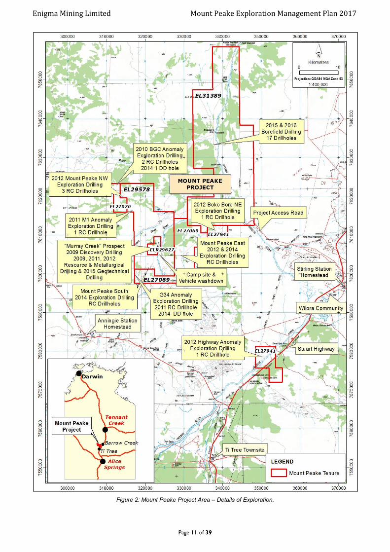
The region has been partially explored for a variety of commodities including nickel, gold, copper, iron ore, bauxite and diamonds, with some areas experiencing limited or no work. The following is a brief summary of historic work reviewed to date, and subsequent work completed by TNG. Location of TNG exploration in the Mount Peake area is shown in Figure 2. All drillholes completed are listed in Appendix 2.
In the early 1970’s CRA conducted Uranium exploration in the area. Work including geological mapping, photo interpretation, air and ground magnetics followed by rotary drilling and borehole logging. CRA resumed exploration in 1979 and over a four year period completed airborne magnetics/ radiometrics, drainage geochemistry, soil and rock chip geochemistry and limited diamond drilling.
Between 1991 and 1997 WMC completed work focused on gold exploration that included data compilation, surface geochem sampling, XRD analyses, geological/regolith mapping, gravity surveys, airborne magnetics/ radiometrics, IP/TEM surveys and ground magnetics. Anomalies were then followed up with an Auger/ RC drill program.
In 1997 WMC optioned the ground to Aberfoyle who completed further rock chip sampling, soil sampling and vacuum drilling on the properties. Aberfoyle withdrew from the J.V and WMC surrendered their properties in 1998.
A garnet/magnetite skarn occurs in the centre of EL23074. This is known as the “Murray Creek” Iron prospect and was drilled by CRA in 1982.
TNG originally applied for the licence area to explore for Ni-Sulphides, and it forms part of the companies “Mount Peake” Project area together with EL 23271. On the 18th August 2003 a Joint Venture agreement with Falconbridge (Australia) Pty Ltd was entered into allowing them to earn a 60% interest.
On the 15th October 2003 Falconbridge (Australia) Pty Ltd entered into a Heads of Agreement with Discovery Nickel Limited (DNL) whereby DNL assumed Falconbridge’s obligations for the Mt Peake Leases. Discovery drilled 2 diamond drill holes in 2004, ARD01 on exploration licence 27070 formally 23392 and ARD02 on exploration licence 23074.
TNG resumed management of the tenement in October 2006 following the failure of the joint venture partners to fulfil its exploration, rent and reporting obligations.
TNG 2007 – 2008 Activities
Assessment of geophysical data collected by the JV partners revealed that one Diamond Drill Hole, ARD02 had been drilled into a large magnetic anomaly targeting an EM target at 200m depth. The hole was stopped at 150.6m having intersected magnetite rich gabbro from 30m.
Inspection of the core by TNG revealed that the core had not been cut or assayed. TNG submitted the core for assay and results show high concentrations of vanadium (V2O5) > 0.5% and titanium (TiO2) >8% in the magnetite grading >35% Iron (Fe). Davis Tube Recovery test work has since been completed providing significant encouragement in both recovery of >65% and upgrades to potential commercial grades of >1% V2O5, 17% TiO2, 55% Fe.
TNG 2009 Activities
During 2009 TNG drilled 20 Reverse Circulation (RC) and 4 diamond drill holes in the vicinity of the “Murray Creek” Iron prospect, and collect samples from the drill material for analysis for Ni, Cu, Fe, Ti, V, and other minor elements.
The RC and diamond drilling programmes were completed at the Mount Peake Prospect in February and October - November 2009. The October - November programme was aimed at infilling and testing extensions to the existing Inferred Resource. The 16 hole programme confirmed that the strike length of the magnetite mineralisation is over 1300m and open in all directions.
The consistent mineralisation with intersections of up to 165m indicated significant potential for a substantial resource. Initial metallurgical work confirmed the extraction of a vanadium concentrate.
The 2 diamond drillholes (09MPDD01-02) were completed for 225.4m. Both holes were pre-collared and drilled PQ in order to obtain a large sample for metallurgical testwork.
Enigma Mining Limited Mount Peake Exploration Management Plan 2017
Page 9 of 39
A further 2 diamond drillholes (Stirling Deeps; SDDD001-SDDD002) aimed at providing information on the nature and extent of a potential layered mafic intrusion in the Western Arunta province, were completed with funding provided by the N.T. Governments collaborative funding programme. Immediately after the drilling had been completed, the drill holes were capped, the work sites cleaned up and the drill core transported back to the N.T.’s core storage facility in Alice Springs.
TNG 2010 Exploration Activities
The 2010 programme included ground geophysical surveys, 2 Reverse Circulation (RC) drill holes drilled into the “BCG” EM Anomaly, on exploration licence 27070 and regional soil, rock chip and field XRF analysis. Samples collected from the drill material and regional sampling was analysed for Ni, Cu, Fe, Ti, V, and other minor elements. All samples were sent to ALS Laboratory in Alice Springs for sample preparation and then onto Perth for analysis. Drillers camped in a clear area close to the drill site
TNG 2011 Exploration Activities
The 2011 program at the Mount Peake Iron – Vanadium project included drilling eight PQ diamond drill holes for a total of 1,082.6 metres spaced two hundred metres apart along the centre of the anomaly. The diamond drill holes were designed as part of the resource upgrade and to collect representative drill core along the ore body for further metallurgical test work. The entire drill core was transported to Perth where metallurgical bench top test work has been completed and pilot plant test work on TIVAN™ processing commenced.
In addition to the 8 DD holes, 24 RC holes for a total of 2748 metres were drilled over the Mount Peake deposit.
These holes were designed to bring the Mount Peake deposit from current JORC resource to Indicated. Three exploration holes were drilled to test geophysical anomalies. Anomaly M1 is within EL23271 and G34
within EL27069, see Figure 1 & 3 for locations and access. Access to M1 and G34 is via grid lines cleared for drilling in 1996 and only minor clearing was needed. An application for a Sacred Site Clearance Certificate was submitted to the CLC and SSCC C2011-062 was issued on 26-07-11.
Site rehabilitation was completed on all 2009 RC and DD holes, 2010 RC drill holes and the 2004 DD hole site
drilled by Discovery Nickel near TNG’s 2010 drill sites on EL27070. The one metre samples remaining on the sites were emptied onto the ground, pushed into a pit and covered over with topsoil. All green plastic sample bags and rubbish was removed to the Ti Tree tip site.
The eight 2011 diamond drill hole sites were also rehabilitated immediately after the completion of the hole. Sump water was pumped to a central holding sump. All plastic sump liners were removed with all rubbish to the Ti Tree town tip site. All drill sumps were back filled and the drill pad and sumps covered with stored topsoil.
TNG 2012 Exploration Activities
During the period April 18-28, 2012 TNG drilled 8 RC holes totalling 1266m to assess regional magnetic anomalies. Three holes were drilled in the NW corner of tenement EL23271, 3 holes were drilled on the Boundary Fence (Mt Peake East) Anomaly, one hole on Eastern Bullseye Anomaly and one on the Highway anomaly. Another hole had been planned for the southern part of the Highway Anomaly, but was not drilled as access track could not be cleared in time for drilling.
During the period November 15th to December 10th 2012, TNG drilled 59 RC holes totaling 7168m and 14 PQ diamond drill core holes totaling 1892m. Drilling activity was focused on the existing V-Ti-Fe resource at Murray Creek on EL 29578 and had three specific aims:
1. Upgrade the existing resource – from inferred to indicated and/or measured status 2. Add to the resource with step out/down dip holes (outside the existing resource) 3. To provide bulk samples for metallurgical work to deliver to METS as required.
The initial programs of 58 RC and 15 DD holes were designed by Snowden. Planned diamond drill hole 12MPDD023 was drilled as 12MPRC094 as sufficient core with grade to be used as metallurgical sample had been obtained from 14 holes drilled.
Approximately 5500 RC samples were submitted to ALS in Alice Springs for sample preparation before shipment to Perth for analysis.
All diamond drill core was transported to ALS Global in Perth for metallurgical testwork and further TIVAN™ pilot plant testing.
Enigma Mining Limited Mount Peake Exploration Management Plan 2017
Page 10 of 39
At the completion of drilling plastic sump liners and rubbish was removed from site to the Ti Tree townsite rubbish tip.
A site monitoring exercise was conducted by the Operations Manager at the end of the April drilling with an inspection of all access roads and drill sites completed by TNG.
TNG 2013 Exploration Activities
No major ground disturbance programmes were undertaken on the Mount Peake authorisation during 2013 except during the drill site rehabilitation where a mini excavator was used to dig pits to bury drill sample cutting and spoil.
A baseline flora and fauna survey of the mine site area and transport corridor was undertaken by GHD; 9th to 16th April 2013.
A drill site rehabilitation program was undertaken in May 2013. Sites rehabilitated were from the drilling programs conducted in 2011 and April 2012. Drill hole collars were cut 50cm below ground level plugged with a plastic plug and covered with top soil. Drill cuttings were emptied into a pit with the drill spoil and covered with top soil. All plastic sample bag material was taken to the Ti Tree rubbish tip. Drill pads were cleaned and smoothed over using a mini excavator.
A magnetic Lag soil sampling program was conducted during Oct – Nov 2013 over a number of AEM targets within the Mount Peak Project to generate future drill targets.
Rehabilitation of the 2012 Mount Peake mineral resource drill holes commenced in December 2013. This phase was to remove deteriorating plastic sample bags referred to in DME’s mining officer’s field inspection report 2 May 2013.
The Mount Peake Project “Notice of Intent” (NOI) was lodged in July 2013 and the Mount Peake Project, Referral under the EPBC Act submitted in October 2013.
A site audit for drill hole failure, weeds and erosion of all drill sites and tracks established by TNG was undertaken in April 2013. No hole failures, erosion or weeds were observed.
TNG 2014 Exploration Activities
Following mapping and sampling over the regional magnetic targets in November 2013 a four kilometre anomalous V-Ti-Fe lag geochemical target was outlined at the Eastern Target (about 5 to 8km east of the Mount Peake Resource. It coincided with mapped magnetite bearing gabbro and warranted drilling.
A total of 18 RC drill holes were planned for 2800 metres to drill test the Eastern, Western and South-western Regional Magnetic Targets. Only 16 holes for 1,647 metres were drilled from the planned 18 due to the grades obtained at near the lower resource cutoff grade. Three water table monitoring holes were drilled to assess the likely impact to the ground water around the resource associated with pit dewatering. Two monitoring holes were drilled on the eastern side of Murray Creek adjacent to the resource and one to the south of Mud Hut Swamp.
Mud Hut Swamp is not included within a formal network of protected areas, however it has been identified as a Site of Conservation Significance and is listed in the ‘Inventory of sites of international and national significance for biodiversity values in the Northern Territory’. The Swamp has also been identified as an area of cultural significance and identified as Restricted Work Area 8 (RWA8) on Sacred Site Clearance Certificate – No.2012-007a. No exploration activities are approved within or around the Swamp ensuring that the area is not impacted by exploration.
TNG announced that it had appointed leading global engineering and environmental consulting group GHD to complete the Environmental Impact Study (EIS) for the Mount Peake project. The EIS will evaluate the environmental impacts of mining and processing the magnetite deposit at Mount Peake. A ground water monitoring programme assessment on the resource commenced at the same time to coincide with the exploration and bore monitoring drilling.
In July 2014, TNG submitted an amendment to the MMP for additional drilling. The amendment was for TNG to re-enter two previously drilled RC holes (10RCBGC001 & 11RCG34) that had intersected a graphitic schist, redrill through the graphite intersection using a diamond drill rig to get drill core required for further metallurgical flotation test work. The program commenced on 20 August 2014 and was completed on 8 September 2014 for a total of 205 metres.
Rehabilitation of the October – December 2012 resource drilling, the March 2014 regional drilling and the two diamond drill holes from the September 2014 was completed.
Enigma Mining Limited Mount Peake Exploration Management Plan 2017
Page 11 of 39
Figure 2: Mount Peake Project Area – Details of Exploration.
Enigma Mining Limited Mount Peake Exploration Management Plan 2017
Page 12 of 39
TNG 2015 Exploration Activities
Work on the DFS and EIS continued throughout 2015 and were completed during the year.
In December 2014 TNG submitted an amendment to the MMP for the drilling of six diamond drillholes around the expected perimeter of the pit wall. Drill core samples from these holes were required to complete geotechnical studies required for the Definitive Feasibility Study. The programme commenced on 21 February 2015 and was completed by the 31st March 2015 for a total of 579.8m.
Following the geotechnical drilling a waterbore drilling programme was undertaken in the palaeochannel to the west of the existing Hanson River watercourse (Figure 3; Table 1 & 2). Holes were designed to require a minimum of clearing and track construction and most were sited along the side of the existing station access tracks. Holes 15MPWB001 and 005 were located at the abandoned Middle Well. Here the existing station track around the abandoned yards was utilised and widened only around the drill collar position. The station track heading east to Middle Well from the main N-S access was refurbished as part of this programme.
Hole 15MPWB003 was drilled near the current channel of the Hanson River and approximately 1000 metres from the north/south track. An open and burnt out area (bushfire in 2013-4?) was chosen to access this hole site, no trees were felled, and the grader did not need to cut the ground surface.
Sumps were constructed at each drill site to contain the water generated while drilling and during pump testing. The soil in the vicinity of all holes was sandy, being predominantly alluvial silty sands, and so water generated by drilling soaked in to the ground quickly. Sumps were dug using a small excavator and were approximately 2m x 4m x 1m deep. They were sited downhill from the collar on the drill pad. On drillhole sites where large water volumes were encountered a small “dam” was constructed with walls to contain the water approximate 0.2m to 0.4m high pushed up with the small excavator. The enclosed area was generally 10-15 metres in diameter and within the drill pad area. In this programme only drillhole 15MPWB003 had a small dam constructed.
Drillers camped on open ground at Middle Well and no clearing was required for the campsite, but the track to Middle Well was refurbished as mentioned above. This area has been included in the calculation of cleared land as there was still remediation work required to return the site to ‘pre-camp’ conditions. The camp site was left clean and tidy after the completion of the programme. TNG staff were accommodated at Stirling Station.
Rehabilitation of all pre-2015 drilling had previously been completed and the 2015 geotechnical and waterbore holes were rehabilitated in May 2015. All geotechnical holes were plugged at least 40cm below the ground, sump liners removed and topsoil respread across the sites. A Field Inspection was carried out by Departmental Officers in June 2015 and a number of recommendations were made which were dealt with during a rehabilitation site visit in November 2015.
Water bores were sealed appropriately as per the NT Department of Land Resource Management Water Resources Division guidelines. More details in Section 5.4.
TNG 2016 Exploration Activities
During March 2016 site monitoring was carried out at Mount Peake. All monitoring sites were visited and photographed. No remediation was required at any site.
Review of the EIS lodged in December 2015 resulted in a number of additional requirements, including more water bore drilling in order to confirm the extent of the aquifer and the amount of water available throughout the life of the mine and beyond.
Ten holes were drilled along the Hanson River palaeochannel as part of this additional water resources study (Figure 3). Nine of these are expected to remain as monitoring bores (16MPWB06-14) and one a production bore (16MPWB15). An additional production and monitoring bore were drilled in December 2016 on issue of a Bore Construction Permit (BCPWDP05693) from the Water Resources Division of the Department of Environment and Natural Resources. These holes (16MPWB016 and 017) were drilled from the same pad as 16MPWB007 (Figure 3).
Clearing was kept to a minimum. Existing station tracks were used in all cases, an old track north from the Browns Yards was refurbished and used as access to 16MPWB10 and 11. Hole 16MPWB15 is on the same drill pad as 16MPWB08 (Figure 3).
Sumps were constructed at each drill site to contain the water generated while drilling and during pump testing. The soil in the vicinity of all holes was sandy, being predominantly alluvial silty sands, and so water generated by drilling soaked in to the ground quickly. Sumps were dug using a small excavator and were approximately 2m x 4m x 1m deep. They were sited downhill from the collar on the drill pad. On drillhole sites where large water volumes were encountered a small “dam” was constructed with walls to contain the water approximate 0.2m to 0.4m high pushed up with the small excavator. The enclosed area was generally 10-15 metres in diameter and within the drill pad area. Holes with small dams constructed were: 16MPWB007, 16MPWB008/015, 16MPWB012 and 16MPWB014.
Enigma Mining Limited Mount Peake Exploration Management Plan 2017
Page 13 of 39
Total clearing of drill pads and the refurbished access track amounted to 3.2 hectares (See below). Holes 16MPWB06-09 were drilled adjacent to the station track from Browns Well to Wollogolong Bore and drill pads for holes 16MPWB07 and 16MPWB09 were smaller than others as they were located on track junctions.
In 2016 TNG staff camped at Middle Well and the drillers camped on the open ground adjacent to Browns Well and no clearing was required. This area has been included in the calculation of cleared land as there was still remediation work necessary to return the site to ‘pre-camp’ conditions. Camp sites were left clean and tidy on completion of the programme. Cleared track and campsite locations are shown in Figure 4.
To date all rehabilitation of drillsites across the Mount Peake project area has been completed, including the 2015 and 2016 waterbores. Two of the three Mount Peake resource campsites have been fully rehabilitated and the third campsite and access tracks are currently being monitored and remediated as required. Tracks will remain open for the foreseeable future. Photos were included in the Mount Peake Exploration Management Plan 2016.
TNG 2017 Exploration Activities
Site monitoring and a waterbore drillhole and access track audit was carried out at Mount Peake in November 2017. Photographs were taken at the sites of the waterbore drilling and are included in Appendix 3 (along with 2016 photographs for comparison). All sites are revegetating well. Current Monitoring Sites were also visited and photographed, these photographs are included in Appendix 4 (along with 2016 photographs for comparison). Three additional monitoring stations were added as a result of the waterbore drilling (further information in Section 5.5.2 – Table 10). These include drillsites 15MPWB02, 15MPWB03 and the access track to 15MPWB03. All these areas are rehabilitating well and no remediation was required. Photographs of these sites are included in Appendix 4.
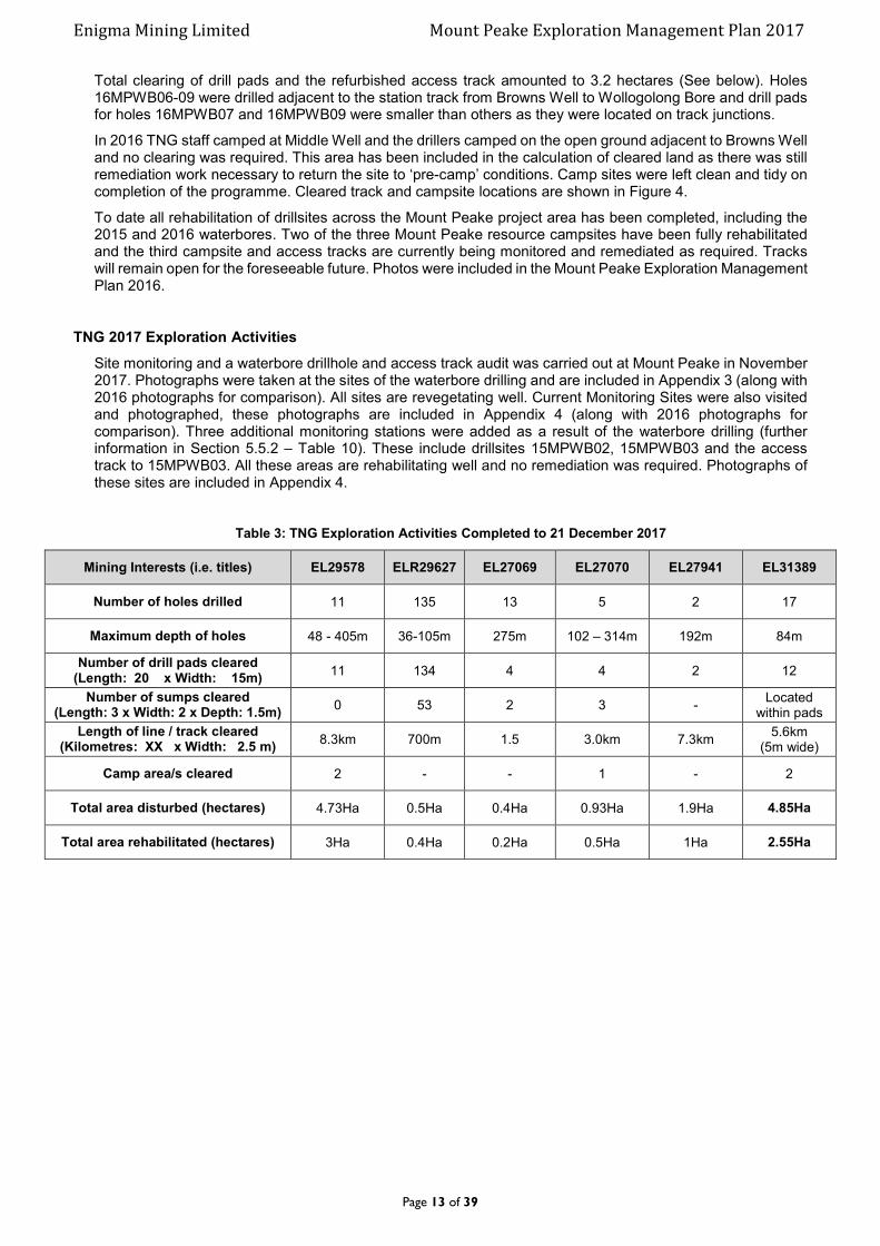
Table 3: TNG Exploration Activities Completed to 21 December 2017
Mining Interests (i.e. titles) EL29578 ELR29627 EL27069 EL27070 EL27941 EL31389
Number of holes drilled 11 135 13 5 2 17
Maximum depth of holes 48 - 405m 36-105m 275m 102 – 314m 192m 84m
Number of drill pads cleared (Length: 20 x Width: 15m)
11 134 4 4 2 12
Number of sumps cleared (Length: 3 x Width: 2 x Depth: 1.5m)
0 53 2 3 - Located
within pads
Length of line / track cleared (Kilometres: XX x Width: 2.5 m)
8.3km 700m 1.5 3.0km 7.3km 5.6km
(5m wide)
Camp area/s cleared 2 - - 1 - 2
Total area disturbed (hectares) 4.73Ha 0.5Ha 0.4Ha 0.93Ha 1.9Ha 4.85Ha
Total area rehabilitated (hectares) 3Ha 0.4Ha 0.2Ha 0.5Ha 1Ha 2.55Ha

Enigma Mining Limited Mount Peake Exploration Management Plan 2017
Page 14 of 39
Figure 3: Location of all Drilled Waterbores.

Enigma Mining Limited Mount Peake Exploration Management Plan 2017
Page 15 of 39
Figure 4: Tracks and Campsites Cleared During the 2015/16 Waterbore Drilling.
Enigma Mining Limited Mount Peake Exploration Management Plan 2017
Page 16 of 39
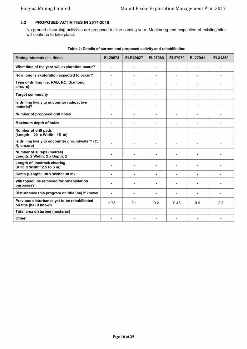
3.2 PROPOSED ACTIVITIES IN 2017-2018
No ground disturbing activities are proposed for the coming year. Monitoring and inspection of existing sites will continue to take place.
Table 4: Details of current and proposed activity and rehabilitation
Mining Interests (i.e. titles) EL29578 ELR29627 EL27069 EL27070 EL27941 EL31389
What time of the year will exploration occur? - - - - - -
How long is exploration expected to occur? - - - - - -
Type of drilling (i.e. RAB, RC, Diamond, aircore)
- - - - - -
Target commodity - - - - - -
Is drilling likely to encounter radioactive material?
- - - - - -
Number of proposed drill holes - - - - - -
Maximum depth of holes - - - - - -
Number of drill pads (Length: 20 x Width: 15 m)
- - - - - -
Is drilling likely to encounter groundwater? (Y, N, unsure)
- - - - - -
Number of sumps (metres) Length: 2 Width: 2 x Depth: 2
- - - - - -
Length of line/track clearing (Km: x Width: 2.5 to 3 m)
- - - - - -
Camp (Length: 30 x Width: 30 m) - - - - - -
Will topsoil be removed for rehabilitation purposes?
- - - - - -
Disturbance this program on title (ha) if known - - - - - -
Previous disturbance yet to be rehabilitated on title (ha) if known
1.73 0.1 0.2 0.43 0.9 2.3
Total area disturbed (hectares) - - - - - -
Other: - - - - - -
Enigma Mining Limited Mount Peake Exploration Management Plan 2017
Page 17 of 39
4.0 CURRENT PROJECT SITE CONDITIONS
4.1 GEOLOGY
The licence areas are generally flat with some broad low ridges of silcrete or ferruginous rock formations. Broad flood plains associated with the Murray Creek which runs through the licence area are also a feature.
The project area lies within the north-central portion of the Paleoproterozoic Arunta Province. The stratigraphy of the Arunta province comprises relics of 2500 Ma Archaean basement overlain by >1800 Ma Palaeoproterozoic, turbiditic sequences of greywacke, quartz, sandstone, siltstone and shale along with mafic rocks and their high-grade metamorphic equivalents. The Arunta also has minor calc-silicates and meta-felsic volcanic units. During the Barramundi Orogeny, the sedimentary units were intruded by mafic rocks which have been deformed and in places metamorphosed to amphibolite facies. During the closing stages of the Barramundi Orogeny (~1830 Ma) granite plutons intruded rocks of the Arunta Province.
In the tenement area, rocks of the Palaeoproterozoic Lower Hatches Group/ Reynolds Range Group occur, comprising undifferentiated granite/granite gneiss and gabbro-dolerite. Neoproterozoic to Palaeozoic rocks of the Georgina Basin cover the Palaeoprotoeozoic rocks in the south to southeast. Cainozoic sediments also cover parts of the tenements. Quaternary and Tertiary cover sequences of variable depth (ranging from a few metres to in excess of 100m) conceal the basement rocks. Mafic/ ultramafic units have been recorded from previous drilling within and adjacent to the tenement, enhancing the prospectivity for Ni-Sulphide and other mineralisation.
Geology of magnetite mineralisation
The Mount Peake gabbro body is located within outliers of Neoproterozoic sediments of the Georgina Basin. The Neoproterozoic sediments rest unconformably on metasediments and granites of the Aileron Province within the Lower Proterozoic Arunta Region. Bedrocks comprise metasediments, granites and metamorphosed basic rocks. The mineralised Mount Peake gabbros are part of a 10x20km NW trending sill or sill complex -interconnected sills at different stratigraphic levels- that will be called Murray Creek Sill. Judging from the magnetic images at least two more sills/ sill complexes are present in the eastern part of the Mount Peake sheet/ western part of Barrow Creek. The Murray Creek Sill comprises gabbros, olivine gabbros, and leucogabbros with magnetite rich olivine gabbros near the top of the sill. Where the basal contact to the sill has been intersected in the stratigraphic holes SDDH1 and SDDH2 the thickness of the sill is around 250-300 m, and the mineralised zone must be very close to the top of the sill. Most of the rocks in the sill are only moderately magnetic outside the mineralised zone near the top.
Based on summary logging of the deep diamond drill holes SDDH1 and SDDH2 the Mount Peake Ti-V-Fe ore body is hosted by a differentiated basic sill with minor ultrabasic layers. The predominant rock type is olivine gabbro with layering defined by variations in plagioclase / olivine+clinopyroxene ratios. Most of the gabbros are massive- typical of many layered intrusions-without discernible layering.
The May 2011 diamond drilling and the July 2011 RC drilling showed that the thick intersections of V-Ti rich magnetite located in 2009 are continuous over many hundred meters, and the margins of mineralisation are now much better defined, but much more close spaced pattern drilling is required to upgrade the status of the resource.
In the area tested by the recent diamond and RC drilling 4 units of basic/ ultrabasic rocks were encountered. They are described below in descending stratigraphic order.
1. GAB. Massive coarse grained (olivine) gabbro with only minor interstitial magnetite. This unit is coarser grained than olivine gabbros below the mineralised gabbros and has higher P content (>O.2%) versus <0.2 %. Magnetic susceptibility is normally low. Minor biotite is present.
2. The mineralised layers have 2 components:
a. MOG. A magnetite enriched olivine gabbro with plagioclase laths showing a weak to moderate
lamination. Cumulate magnetite forms 20-50% of the gabbros. Susceptibility is high. Trace amounts
of biotite and ilvaite are present. The mineralised unit differs from gabbroic units below and above in
having a much higher concentration of magnetite and having cumulus lath shaped plagioclase aligned
to form a rough lamination. The concentration of plagioclase is generally lower than in the surrounding
gabbros/ olivine gabbros due to the diluting effect of the magnetite. Olivine and pyroxene seem to be
more abundant in the lower part of thick mineralised zones e.g. in 11MPDDH 005-006.
b. MPER. A magnetite enriched olivine-clinopyroxenite with little or no plagioclase. This ultramafic forms
layers varying in thickness between 5 cm and 100 cm. Individual layers cannot be correlated from
hole to hole. Susceptibility is high.
Both the gabbroic and ultramafic component contain cm to dm size xenoliths of underlying unmineralised olivine gabbro. These xenoliths have intercumulate magnetite. Rare centimetre to decimetre sized anorthosites (AN) and troctolites (TROC) are found within the mineralised unit. In MPDDH003 there is a basic pegmatite (PEG) in the lower part of the mineralisation

Enigma Mining Limited Mount Peake Exploration Management Plan 2017
Page 18 of 39
3. OG. Medium grained olivine gabbro with minor magnetite with abundant plagioclase oikocrysts and
generally without plagioclase laths. The magnetite is mainly interstitial. Some of the rocks are slightly
leucocratic LOG. Susceptibility is moderate to low.
4.2 HYDROLOGY
Murray Creek is the main watercourse through tenement EL29578. It enters the tenement from the southern boundary heading in a northerly direction for about the first 8 kilometres before meandering in a north-easterly direction before draining into the Hanson River. The creek bed is sandy and about 150 metres wide with gums (Eucalyptus camaldulensis) along the banks.
Bloodwood (Ennugan) Creek) also runs through part of the tenement which drains onto a large claypan “Mud Hut Swamp” on the northern boundary. The creek bed is relatively sandy and about 50 metres wide before it narrows down and spreads into smaller channels where it drains into the claypan.
There are number of water bores within the project area (Figure 6). Water quality at a number of these bores is poor and is used for stock only. With permission from the Stirling Station landowner, potable water for the camps is carted from Mistake Bore, approximately 20 kilometres southeast of the camp site, a return trip of 70km by road. Water used for the October – November 2009, 2011 and 2012 diamond drilling was pumped from RC drill hole 09MPRC001 from a depth of 50 metres and is quite saline.
Water resources for the proposed Mount Peake minesite are likely to be sourced from a large aquifer system within the Hanson Palaeochannel which lies beneath the Hanson River around 20km from the Mount Peake deposit (Figure 5).

Enigma Mining Limited Mount Peake Exploration Management Plan 2017
Page 19 of 39
Figure 5: Hydrology – Water Bore and Aquifer Locations.
Enigma Mining Limited Mount Peake Exploration Management Plan 2017
Page 20 of 39
4.3 FLORA AND FAUNA
Baseline ecological surveys (flora and fauna) of the Mount Peake Project Area (mine area and transport corridors) were conducted in April 2013 to determine the potential implications of the Project under the Commonwealth Environment Protection and Biodiversity Conservation Act 1999 and to provide information for decisions made under the Territory Parks and Wildlife Conservation Act 2006 and the Northern Territory Environmental Protection Authority Act 2012.
Additional studies have been completed since 2013 (November 2016 – GHD, September 2017 – APM) and a comprehensive Biodiversity Management Plan has been submitted to the NT EPA in November 2017. This plan outlines the processes and procedures that are practical and available to minimise the extent and impact of the activities involved during construction and operation of the Mount Peake minesite.
Flora
The project tenements sit within the Burt Plains Bioregion which is dominated by earthy, alluvial soils. The bioregion is broadly characterised by plains of Acacia shrubland, tussock and hammock grassland, and Acacia and Eucalyptus woodlands, NRETAS (2009).
The fine-scale vegetation mapping identified eight broad vegetation communities within the Project area. Broadly, the dominant vegetation types to be impacted by the Project are:
Mulga shrublands, which occur on alluvial fans and plains containing clayey red earths;
Triodia hummock grasslands which grow on sandy plains and undulating hills; and
Riparian woodland along watercourses and drainage channels within the predicted groundwater
drawdown cone for the borefield.
Of particular note is Mud Hut Swamp which is the largest swamp in the Burt Plains bioregion, remaining inundated for several months after flooding events. The majority of exploration has been on the Mount Peake resource located about 8 kilometres to the south of Mud Hut swamp and has not impacted on the swamp area.
A total of 238 species of flora were recorded within the study area, comprising 233 native species and five exotic species. This represents about 22% of all flora species within the Burt Plains bioregion.
Threatened Flora Species
The Environmental Protection and Biodiversity Conservation (EPBC) search tool and NT herbarium database indicate that one species, listed as vulnerable under the EPBC Act and the Territory Parks and Wildlife Conservation (TPWC) Act has been recorded in the project area:
Dwarf Desert Spike-rush (Eleocharis papillosa)
Dwarf Desert Spike- occurs within freshwater and semi-saline ephemeral wetlands, with above-ground plant material emerging from tubers in response to inundation or flooding. Marginal habitat for this species was observed within the Mount Peake Project Area; however, no individual flora species listed as threatened were recorded as part of studies by consultants GHD in April 2013 or follow up work in November 2016. The above species was however found in abundance in the September 2017 survey by Animal Plant Mineral (APM).
No flora species classified as near threatened were recorded as part of any of the studies in the area.
Introduced Flora Species
Weeds have the potential to be introduced and spread via vehicle and stock movements and the stripping of topsoil. The locations of significant infestation of weeds and introduced flora species will be photographed and marked using a handheld GPS unit, including species present, and an estimate of the density and extent of any infestations and reported to the Weed Management Branch, Department of Land Resource Management.
A declared weed is a plant or species of plant which has been identified for control, eradication, or prevention of entry in all or part of the Territory under the Northern Territory Weeds Management Act 2001 (the Act).
A weed may be declared as:
Class A To be eradicated
Class B Growth and spread to be controlled
Class C Not to be introduced to the Territory
All Class A and Class B weeds are also considered to be Class C weeds.
Five exotic flora species were recorded within the study area:
Buffel Grass (Cenchrus ciliaris)
Bitter Melon (Citrullus lanatus)
Enigma Mining Limited Mount Peake Exploration Management Plan 2017
Page 21 of 39
Elastic Grass (Eragrostis tenuifolia)
Caltrop (Tribulus terrestris)
Mimosa Bush (Vachellia farnesiana)
One of these species, Caltrop (Tribulus terrestris) is listed as a Class B and Class C noxious weed under the NT Weeds Management Act. This species was found in low abundance throughout the study area. It is likely that the species is spread predominantly by cattle movement. Overall the introduced species occur in low abundance across the study area. Any occurrence of Caltrop will be noted and physically removed from site and taken to Alice Springs for disposal.
Fauna
In total, 280 fauna species have been identified for the Project Area. This species list includes the PMST report, DLRM database and the fauna survey results. Of the species, 268 are native to the Northern Territory (40 mammals, 145 birds, 74 reptiles and nine amphibians).
Threatened Fauna Species
The DLRM Fauna Atlas and the PMST results identified 22 threatened or near-threatened vertebrate species (15 mammals, 6 birds and one reptile) for the Study Area. Twenty of these are listed under the EPBC Act and all are listed under NT legislation (TPWC Act). Some of the species (all mammals) are considered extinct in the Northern Territory, and others are predicted to occur but have never before been recorded within the Burt Plains Bioregion.
Sixteen threatened or near-threatened species (six mammals, six birds, three reptiles and one frog) are considered likely to occur within the Study Area, either as residents or visitors. Many of these are expected to be rare or very rare.
During the April 2013 baseline survey, a number of fauna species listed under the EPBC Act were identified as being present or potentially present in the Study Area. These species included:
Black-footed Rock-Wallaby (Petrogale lateralis lateralis) (MacDonnell Ranges Population);
Greater Bilby (Macrotis lagotis); and
Great Desert Skink (Liopholis kintorei).
Based on these April 2013 survey results, fauna desktop assessment and the Terms of Reference set by the NTEPA for assessment of the Mount Peake Project, additional targeted threatened species survey work was required to obtain sufficient information on potential impacts of the Project on the threatened species listed above.
In addition to these species five other threatened species were noted during the April 2013 and/or November 2016 surveys. These species included:
Grey Falcon (Falco hypoleucos) – Recorded April 2013
Woma Python (Aspidites ramsayi) – Recorded April 2013
King Brown Snake (Pseudechis australis) – Recorded April 2013
Emu (Dromaius novaehollandiae) – Recorded April 2013 and November 2016
Australian Bustard (Ardeotis australis) – Recorded April 2013 and November 2016
Of the other threatened species considered likely to occur within the project area but not detected, the following are considered likely in particular identified habitats:
Common Brushtail Possum (Southern NT) (Trichosurus vulpecula vulpecula)
Kultarr (Antechinomys laniger)
Spectacled Hare-wallaby (Lagorchestes conspicillatus)
Bush Stone-curlew (Burhinus grallarius)
Giant Frog (Litoria (Cyclorana) australis)
The Greater Bilby was not observed at any stage despite extensive targeted searches of all areas of potentially suitable habitat along the proposed access road alignment. However, diggings were found 11 km from the proposed impact areas in April 2013. Confidence in these diggings being made by Greater Bilby was reasonably high (J. Kuiper, GHD Ecologist; pers. comm.; Formerly with Australian Wildlife Conservancy). This determination is made on the basis of these possible diggings and areas of potentially suitable spinifex sandplain habitat containing witchetty bush (Acacia kempeana) particularly along the proposed alignment, apparent intent of the diggings (i.e. targeting a food source of termites and/or shallow roots), the appearance and characteristics of the scratchings (e.g. sharp edge to scrapes, two or three obvious claws marks), and proximity to historical Greater Bilby records. Therefore, the presence of Greater Bilby in the broader region is considered possible. A proposed monitoring program has been designed to detect changes in the population locally over the life of the project.

Enigma Mining Limited Mount Peake Exploration Management Plan 2017
Page 22 of 39
The Black-footed Rock-wallaby was not detected within the Project area during the April 2013 or November 2016 fauna surveys, but its presence in the nearby Djilbari Hills was confirmed by a GHD ecologist during a helicopter flight for vegetation mapping in April 2013 and a scat was collected by APM in 2017 adjacent to the Djilbari Hills. There is the potential for individual rock-wallabies foraging on the plains or dispersing between ranges to occasionally move through the Project area. A proposed monitoring program has been designed to detect changes in the population locally over the life of the project.
The Brush-tailed Mulgara was not observed, but was considered likely to be present based on the observations of fresh active burrow diggings and scratchings by GHD zoologists with requisite experienced derived from recent nearby surveys of the Burt Plain area of the NT. Failure to detect a live animal at the burrow using a remote sensing camera may indicate relatively low abundance of the species at this site, but may also be explained by the species’ known sensitivity to disturbance, and the likelihood that Brush-tailed Mulgara have numerous burrow entrances that would be used preferentially in response to disturbance. The Brush-tailed Mulgara is considered potentially present in the Project area. A proposed monitoring program has been designed to detect changes in the population locally over the life of the project.
A single Great Desert Skink (Liopholis kintorei) was observed fleetingly on a cool and cloudy morning during the November 2016 survey, at the edge of an access track in open sandplain within spinifex (Triodia spp.) understorey, approximately 7 km from the proposed access road. Subsequent searches of the area surrounding the sighting failed to detect any further signs of this species, such as communal burrow systems or latrines. It is anticipated that this species may occur in suitable habitat within or near to the Project area. A proposed monitoring program has been designed to detect changes in the population locally over the life of the project.
Based on the survey efforts of the 2013, 2016 and 2017 assessments, observations of suitable habitat features, and advice and field assistance from local specialist ecologists from Desert Wildlife Services, the failure to detect a live Greater Bilby or Brush-tailed Mulgara, and observation of only a single Great Desert Skink and no burrows, suggests that none of these species is likely to be present in large numbers within the Study Area. However, arid fauna typically have breeding strategies that allow them to respond rapidly to improving conditions. Thus, future population sizes may differ greatly from current population sizes, and the value of potentially suitable habitat cannot be overstated.
Aside from the Black-footed Rock-wallaby, the threatened species detected are species that have broad distributions across Australia. The narrowest distributions are those of the two mammal species (Greater Bilby and Brush-tailed Mulgara), whose distributional ranges have declined in recent decades, most likely in response to a combination of predation by feral cats, habitat disturbance and degradation due to grazing, weed invasion, and increased use of fire across the landscape.
Ground-dwelling species (reptiles, non-volant mammals, flightless birds) that have limited mobility across the landscape are perhaps most at risk from localised habitat changes that may result from construction and operation of a mine in the Study Area.
Introduced Fauna Species (Feral/Pest Animals)
Database searches show that twelve non-native fauna species have been recorded within the vicinity of the Project area. However, only four were observed by GHD and one further species by APM. The potential and recorded species comprise ten mammals, one bird and one reptile. A summary of non-native fauna species identified in the PMST and Fauna Atlas database and those observed onsite are provided in Table 5.
Table 5: Non-native fauna species identified for the Project area.
Name Classification
Common Scientific DLRM PMST GHD/APM
Mammals
Cat Felis catus
European Rabbit Oryctalagus cuniculus
Donkey Equus asinus
Dog (domestic) Canis lupus familiaris
House Mouse Mus musculus
Red Fox Vulpes vulpes
Horse Equus caballus
Pig Sus scrofa
Cattle Bos taurus
Camel Camelus dromedarius
Enigma Mining Limited Mount Peake Exploration Management Plan 2017
Page 23 of 39
Birds
Rock Dove Columba livia
Reptiles
Asian House Gecko Hemidactylus frenatus
4.4 CURRENT LAND USE
The current land use over the project area is predominantly pastoral activity. The tenements lay within:
1. PPL 1103 – “Striling” Station Pty Ltd (cattle grazing) 2. PPL 1057 – “Anningie” Station (cattle grazing)
Further details are included in Section 2.0 Identified Stakeholders.
4.5 HISTORICAL, ABORIGINAL, HERITAGE SITE
Registration of Native Title Determination Application – DC11/12 Stirling and Neutral Junction NTD17/2011 was registered with the National Native Title Tribune 17 August 2011. The application was accepted for registration under section 190A of the Native Title Act 1993 (the act) and accordingly, entered onto the Register of Native Title Claims 19 August 2011.
In 1995 AAPA conducted a survey to identify Significant Sites under the Aboriginal Heritage Act. The survey identified a number of ridges and hills, temporary waterholes and the large claypan “Mud Hut Swamp” as Significant Sites.
TNG work areas have been cleared by the CLC and Certificates – C2008-090, C2010-015, C2011-062, C2012 – 007a, C2014-001, C2015-034 and C2015-169 have been issued.
An application for authorisation has been submitted to AAPA for the Mount Peake Minesite, Campsite, Transport Corridor, Pipeline Corridor and Borefield. Input is currently awaited from the CLC.
An Exploration Agreement deed between TNG Limited and The Central Land Council was executed on the 26 May 2010 for exploration licences 23074, 23271, 27069, 27079, 27706, and 27787 and the Exploration Agreement deed for licences 27941 and 28491 was executed on the 6th March 2012. EL 23074 and EL 23271 have since been amalgamated into EL 29578 and EL 27706, EL 27787 and EL 28491 have been surrendered.
A search of the NT Heritage Register and the Australian Heritage Database return no sites of significance with the Mount Peake Project area.
http://www.ntlis.nt.gov.au/heritageregister/f?p=103:300:1863315514318707
http://www.environment.gov.au/cgi-bin/ahdb/search.pl
Enigma Mining Limited Mount Peake Exploration Management Plan 2017
Page 24 of 39
5.0 ENVIRONMENTAL MANAGEMENT SYSTEM / PLAN
TNG Limited is committed to ensuring that environmental responsibility is incorporated as part of their normal business practice. It is the duty of all employees to exercise care in their work to ensure this commitment is achieved.
The procedures outlined in the company’s Environmental Management Guidelines document (Appendix 5) must be followed by all staff and contractors during the course of our field activities and aim to minimise any general degradation of the surroundings that may result from carelessness or neglect. In general these guidelines express common sense practices that might be described as “good housekeeping”.
Access to land for exploration and mining is usually by a lease agreement with the government and other private land users, including pastoralists and aboriginal groups. Individuals therefore have certain obligations on a personal and company basis, to protect the environment.
All work will be conducted in accordance with TNG’s Environmental Management Guidelines. Environmental impacts will be minimal. All drill hole collars will be capped and cut to 400mm below surface in accordance with DPIR Advisory Note – Construction and Rehabilitation of Exploration Drill Sites. Drill pads will be scarified using a grader, when the sumps have dried they will be back filled and covered with stockpiled topsoil. All sample bags will be removed to TNG’s Alice Springs holding yard at the end of exploration programs. Rubbish will be cleaned up immediately after the hole is completed.
Access tracks and grid lines will be located and prepared to provide minimal damage to vegetation and topsoil as per DPIR Advisory Note - Clearing and Rehabilitation of Grid Lines and Tracks.
Destruction or damage of mature trees is strictly forbidden for the duration of TNG’s exploration program.
Environmental reports will be commissioned where intensive exploration is proposed and involves substantial disturbance to the vegetation.
5.1 ENVIRONMENTAL POLICY AND RESPONSIBILITIES
TNG has an Environmental Management Policy under which it operates (Appendix 6). All work will be overseen by the company’s Exploration Manager who is responsible for all site inductions, site preparations, clean-up and rehabilitation operations (described above). These operations will be implemented to industry best practice standards.
5.2 STATUTORY AND NON-STATUTORY REQUIREMENTS
TNG has obligations to meet the requirements of several components of the Northern Territory and
Commonwealth legislation, principally:
Mining Management Act (and Regulations)
Mineral Titles Act (and Regulations)
Aboriginal Land Rights (NT) Act (Com)
Aboriginal and Torres Strait Islander Heritage Protection Act (Com)
Bushfires Act (and Regulations)
Environmental Protection and Biodiversity Conservation Act (Com)
Heritage Act (and Regulations)
Northern Territory Aboriginal Sacred Sites Act (and Regulations)
Soil Conservation and Land Utilisation Act
Territory Parks and Wildlife Conservation Act
Waste Management and Pollution Control Act (and Regulations)
Water Act (and Regulations)
Weeds Management Act
Work Health and Safety (National Uniform Legislation) Act (and Regulations)
Exploration Licence conditions of grant
Authorisation conditions
Other reporting to statutory bodies as required or requested TNG operates under the Code of Conduct for Mineral Explorers in the Northern Territory of Australia (2002).
Enigma Mining Limited Mount Peake Exploration Management Plan 2017
Page 25 of 39
All TNG’s field programs are provided to relevant Stakeholders before exploration commences for comment and discussion. Other agreements include contractual agreements with drilling, earthworks and other exploration associated companies as required. TNG operates under exploration agreements with the Central land Council for EL 27069, EL27070, EL29578, EL 27941 and ELR29627.
5.3 INDUCTION AND TRAINING
All site personnel will be given a formal induction incorporating Occupational Health and Safety (OHS), heritage, cultural and environmental issues and issued with (PPE), hard hats, safety glasses, ear plugs, dust masks and long sleeve work shirts (as required). All personnel must wear steel capped safety boots when on-site. Signs are displayed strategically around the site to indicate PPE requirements in those areas. Before drilling commences a drill rig inspection will be carried out by the exploration geologist and drill rig safety inductions will be organised by the driller. Records of all inductions will be kept either at the Alice Springs or Perth office.
Environmental topics will be included in the site induction programme which all site personnel are required to participate in. The induction program stresses industry best practice guidelines as outlined above. All personnel are required to keep the environment as clean as possible and to maintain minimal impact on waterways, land and vegetation. Destruction or damage of mature trees is strictly forbidden during the course of TNG’s exploration program.
Specific topics covered in the environmental induction:
Dust creation on the way to site and on site must be minimized. Destruction or damage of mature trees is strictly forbidden
Each drill site should show only wheel marks and a hole collar at the completion of the drill hole.
All rubbish will be collect and brought back to Alice Springs for proper disposal.
All oil spills must be reported and contaminated soil must be collected in plastic bags, brought back to
town and disposed of appropriately.
Water flow from drilling must be managed so that the outflow is contained in the nearby sump.
Driving on site should utilize prepared and existing tracks and the disturbance of vegetation must be minimized.
All contact with animals is to be avoided.
All vehicles must be washed before entering and exiting site to minimised transporting seeds. All vehicles
will be fitted with mesh to eliminate seed collecting in radiators.
Field staff will be trained in identifying weeds using The Northern Territory Weed Identification Tool for the Burt Plain Region. All TNG vehicles carry copies of the Guidelines for management of Pest Animals and Weed in the Mount Peake region.

Enigma Mining Limited Mount Peake Exploration Management Plan 2017
Page 26 of 39
5.4 IDENTIFICATION OF ENVIRONMENTAL ASPECTS AND IMPACTS
The main environmental aspects that come into force when conducting exploration (including drilling and associated clearing, vehicle movement and fuel storage) are listed in Table 6. The impacts of these are discussed along with the ways these impacts can be minimized and prevented. Remediation measures are also outlined.
Table 6: Environmental aspects and impacts
Aspect Impact Risk Rating
Management measures (prevention)
Management measures (remediation)
Clearing of tracks / camps / drill pads & sumps.
Damage and loss of vegetation/flora and habitat for native fauna.
High
All site works / clearing will be located and prepared to provide minimal damage to vegetation. Minimize movement of fallen vegetation. Destruction or damage to mature trees is strictly forbidden.
Use existing tracks where possible. New tracks and site works, minimal width and size.
Keep vehicle movement to a minimum.
Take site photos prior to clearing and during rehabilitation restore the area as best can be to pre-cleared topography.
Rehabilitate all site works as quickly as possible.
Monitor sites annually.
Erosion and redirection of surface water.
High
All site works / clearing will be located and prepared to provide minimal damage to existing waterways or changes in surface water flow directions.
Use existing tracks where possible. New tracks and site works, minimal width and size.
Keep vehicle movement to a minimum.
Take site photos prior to clearing taking note of regions of water flow and any pooling.
During rehabilitation restore the area as best can be to pre-cleared topography.
Monitor sites annually for erosion and changed water flow patterns.
Pollution from dust and noise.
Medium to high
Ensure water trucks are on hand during clearing to dampen the soil and prevent excessive dust production.
Do not conduct clearing on windy days.
Limit vehicle noise
If necessary use water truck to spray excessive dust from vegetation – post clearing and post rehabilitation.
Introduction of invasive weed species by machinery.
Special note - Caltrop
Medium
Keep vehicle movement to a minimum through cleared sites.
Washdown vehicles prior to them entering the drill sites.
Check vehicles and machinery daily for weeds and seeds.
If personnel or vehicles venture off cleared tracks shoes and tyres
Monitor rehabilitated sites annually for weed growth and take note of any species that make occur at washdown station.
Take appropriate action, in consultation with Station Owners, if required.

Enigma Mining Limited Mount Peake Exploration Management Plan 2017
Page 27 of 39
will be checked for seed prior to moving to any further location.
Damage to cultural and heritage sites.
High
Contact relevant authorities prior to undertaking clearing in order to make sure significant sites are avoided.
No work should be undertaken in exclusion zones and care should be taken in restricted work areas.
Drilling
Contamination to soil, surface and ground water from hydrocarbon spills and drill slurry.
Medium to High
All equipment checked daily and signed off as being in good working order prior to use onsite.
Drilling companies and TNG carry spill kits.
Use trays to place under areas of potential leaks.
Excessive drill slurry and ground water captured in lined sump.
Isolate the source.
Contain the spill.
Add litter if required.
Remove contaminated soil as quickly as possible and place in plastic bags.
Replace with stockpiled topsoil.
Take contaminated material offsite for disposal.
In case of spill monitor site regularly and take necessary measures to ensure vegetation regrowth and minimal long-term effect on surroundings.
Pollution from dust and noise.
Very High
Drilling rigs and support vehicles must have dust and noise suppressors.
All equipment checked daily and signed off as being in good working order prior to use onsite.
Stop work if excessive dust or very windy conditions.
Have extra water source on hand to dampen surroundings and minimize dust if required.
If necessary use water truck to spray excessive dust from nearby vegetation – post drilling and post rehabilitation.
Danger to fauna from open drill holes, excessive drill cuttings and drill sumps.
Very High
Spread or tip excessive drill cutting back down drill hole and cap drill collar immediately after hole has been completed.
Ensure there is access available out of sumps (ie tree branches) should fauna fall in prior to it drying out.
Clean up around drill collar and cap as soon drill rig leaves the drill pad.
Remove the sump liner as soon as the sump has dried out. Fill in sump and replace topsoil.
Monitor drillsites annually.
Enigma Mining Limited Mount Peake Exploration Management Plan 2017
Page 28 of 39
Damage to cultural and heritage sites.
High
Contact relevant authorities prior to undertaking clearing in order to make sure significant sites are avoided.
No work should be undertaken in exclusion zones and care should be taken in restricted work areas.
Campsites
Contamination to soil, surface and ground water from hydrocarbon spills and generated waste.
Medium
All equipment checked daily and signed off as being in good working order prior to use onsite.
Drilling companies and TNG carry spill kits.
Use trays to place under areas of potential leaks.
Place all rubbish in covered skip bins.
Dispose sewerage into eco pit.
Isolate the source.
Contain the spill.
Add litter if required.
Remove contaminated soil as quickly as possible and place in plastic bags.
Replace with stockpiled topsoil.
Take contaminated material offsite for disposal.
In case of spill monitor site regularly and take necessary measures to ensure vegetation regrowth and minimal long-term effect on surroundings.
Remove all rubbish and waste to the Alice Springs rubbish tip.
Apply lime as required for odour, disease control and waste breakdown.
Danger to flora and fauna from contact with personnel and campsite infrastructure.
Medium to High
Induct field staff in the care and wellbeing of native animals.
Avoid contact with native birds and animals.
Ensure food is left well secured and place all rubbish in covered skip bins.
Dispose sewerage into eco pit.
Remove all rubbish and waste to the Alice Springs rubbish tip.
Appy lime as required for odour, disease control and waste breakdown.
During rehabilitation restore the area as best can be to pre-cleared condition.
Monitor site annually.
Fuel Storage
Contamination of soil, surface and ground water from hydrocarbon leaks or spills.
High
All bulk fuels and oils will be place in bunded areas and monitored daily. The bund will have a heavy duty plastic liner to stop hydrocarbon spillage contaminating soil and ground water.
Only hand held filling nozzles will be use and emergency stop /
Train and induct field staff in the method of using bulk fuel and emergency shutdown procedures.
Isolate the source.
Contain the spill.
Add litter if required.
Remove contaminated soil as quickly as

Enigma Mining Limited Mount Peake Exploration Management Plan 2017
Page 29 of 39
isolation buttons will be fitted.
All small drums up to 20 litres will be place in heavy duty PVC trays.
Spill kits, fire extinguishers and filling procedures will be placed near the bunds / filling station.
possible and place in plastic bags.
Replace with stockpiled topsoil.
Take contaminated material offsite for disposal.
In case of spill monitor site regularly and take necessary measures to ensure vegetation regrowth and minimal long-term effect on surroundings.
Sampling
Pollution from sample material and sample bags.
High
Drill samples will be collected in plastic bags and will remain on-site for up to 6 months.
Sample bags to be placed in naturally clear areas rather than vegetated sites.
Once the samples are no longer required the sample will be tipped into a pit and covered with stored topsoil.
All plastic sample bags will be removed from site and disposed of at the Alice Springs rubbish tip.
Remove all plastic sample bags before they start to deteriorate.
Monitor site annually.
Note: The campsite and vehicle wash down areas are constantly monitored for weeds. No weeds were observed around the campsite during GHD’s flora study or during subsequent site inspections.
It is a requirement to seal aquifers that are intersected during drilling operations and major aquifers will be sealed to prevent inter-aquifer contamination as per the guidelines set out in AA7-029 Construction and Rehabilitation of Exploration Drill Sites. Drilling will be abandoned if necessary to prevent inter-aquifer contamination.
Water bore drilling in 2015 and 2016 encountered only shallow (10-60m below surface) and unconfined aquifer zones. All holes were cased and capped as per the NT Department of Land Resource Management Water Resources Division guidelines.
5.5 ENVIRONMENTAL AUDITS, INSPECTIONS AND MONITORING
This section describes the framework and accountabilities for verifying TNG environmental performance. All environmental audits should be systematic and structured, using an established protocol. Recent and planned audits are listed in Table 7.
5.5.1 Environmental Audits
Procedure
Conduct systems audits to verify whether the environmental management procedures meet the requirements of:
TNG Environmental Policy Australian Minerals Industry (AMI) Code for Environmental Management Action Items from previous audit reports TNG environmental objectives
Enigma Mining Limited Mount Peake Exploration Management Plan 2017
Page 30 of 39
Audit process
The audit process will generally include the following steps:
Establish and agree on timing of the audit. Contact audit participants. Develop a checklist of items to be reviewed. Collect documentation and background information for the area to be audited. Plan the audit. Conduct opening meeting with audit participants. Conduct audit. Collate and present audit observations Prepare and issue audit report.
Audit Schedules
Internal Audits
Internal audits shall be undertaken on an annual basis while exploration activities are in place. Not all aspects of the environmental management procedures need verification each year. The target is that over a two year period all procedures will be audited at least once.
An environmental audit was carried out in April 2013 and the results submitted as part of the 2014 MMP for Authorisation 0477-03. A further site rehabilitation and weed audit was completed in March 2014 and sites rehabilitated through to this time were successfully revegetating with no weeds, erosion or rehabilitation failures apparent.
A visual audit of tracks and drillholes within the Mount Peake resource area was undertaken in September 2016 during monitoring of the 2015 geotechnical drillholes. No remediation was required.
A full audit of all waterbore drilling sites was completed in November 2017. All photographs are included in Appendix 4.
External Audits
The Department of Mines and Energy conducted a Site Inspection in June 2015. All recommendations included in their report were addressed, with additional rehabilitation being undertaken in November 2015.
The DPIR visited waterbore sites in July 2016, no further audits have been completed.
Table 7: Recent and Planned Audits within the Mount Peake Project Area
Audit Type Date
Internal April 2013 Environmental Site Audit – selected drillsites
Internal March 2014 Environmental Site Audit – selected drillsites
External June 2015 DME Site Audit – selected drillsites and access tracks
External July 2016 DME Site Audit – waterbore drillsites
Internal September 2016 Environmental Site Audit – Mount Peake resource drillholes and tracks
Internal November 2017 Waterbores sites and tracks
Audit Findings
The audit findings are distributed to the Managing Director and once reviewed, will be distributed to employees responsible for actioning any of the audit recommendations. Remediation measures will be reported to the DPIR in the subsequent MMP.
5.5.2 Site Monitoring
TNG will ensure that any site monitoring will be managed so as to reduce any adverse environmental impact.
Site monitoring ensures that there is a measure or the impact our activities have on the environment. The monitoring process also provides a guide to how successful or unsuccessful rehabilitation programs have been. Photographic evidence is used in the monitoring and is included in Mining Management Plans submitted to the DPIR. There are currently drillsite, access track and campsite monitoring stations set up at Mount Peake.
This points below cover the general process of site monitoring of areas of environmental impact over TNG tenements. The monitoring involves establishing monitoring sites and taking “before and after” photographs. The

Enigma Mining Limited Mount Peake Exploration Management Plan 2017
Page 31 of 39
photographs provide a record of the company’s environmental impact and a measure of rehabilitation progress. Areas covered are:
Due diligence involves the locating and recording of environmental degradation existing on a
tenement or access tracks to that tenement prior to disturbance by TNG;
Existing and new access tracks monitored to determine the amount of impact that TNG have on the
tracks for the duration of the program. The nature of the ground and how often ground condition
changes will also assist in determining the number of monitoring station. Trouble spots on tracks
such as bulldust areas and creek crossings are of a high monitoring priority. It is best to photograph
tracks during your first pass of the area so a record is kept of the condition they were in prior to TNG
use.
Archaeological/heritage sites: Take before and after shots of archaeological / heritage sites prior to
any exploration activity that may endanger these sites. Monitor the sites, record any adverse
impacts and enter into the annual environmental monitoring report.
Rare or endangered flora and fauna sites: Take before and after shots of rare or endangered flora
and fauna sites prior to any exploration activity that may endanger these sites. Monitor the sites,
record any adverse impacts and enter into the annual environmental monitoring report.
Camp sites: Take before and after shots of campsites in the camp area.
Hydrocarbon or hazardous substance storage facility (fuel dumps): Take before and after shots of
fuel dumps and hazardous substance storage areas.
Sample sites: Set up monitoring stations at sites characteristic of the sampling area. It is important
to emphasise that areas, which are or have the potential to become environmentally degraded are
to be included in monitoring.
Grid lines: If the gridding is of low environmental significance then one monitoring site is adequate
to show the low environmental impact of the work. If the gridding is of high impact significance that
is, it involves vehicles driving along the grid line and scrub clearing then a representative number of
monitoring stations must be set up. The size of the grid and the nature of the ground will determine
the minimum number of monitoring stations. The monitoring program must be designed so that all
ground types affected are represented.
Drill pads: For drilling set up a representative number of monitoring stations. Specific monitoring
stations will be set up for sites that could potentially become an environmental issue.
Drill site and Access Track Monitoring
Six monitoring stations were set up during the early stages of the project (Table 8), to monitor track access to the resource area and 6 drill sites (see table below). These sites were visited and photographed during March 2016 and as rehabilitation has been successful will no longer be monitored. Six monitoring sites were set up at sites visited by the DPIR in June 2015 (Table 8). These sites were visited and photographed in November 2017. No additional drillhole or site rehabilitation is specifically required at any site, though regrowth of vegetation and erosion along access tracks will continue to be monitored. Three new monitoring sites were added along the Mount Peake borefield including the length of the track to 15MPWB003 (Table 8). These sites were visited and photographed in November 2017. All photographs of monitoring sites are included in Appendix 4.
Table 8: Environmental monitoring stations
Mount Peake Project – Environmental Monitoring Stations
Station Easting Northing Ten-ID Prospect Description
322553 7605705 ELR29627 Mount Peake Resource
Drill site 09MPRC001 drilled February 2009 and access track.
322696 7607003 ELR29627 Mount Peake Resource
Drill site 09MPRC002 drilled February 2009.
322612 7606505 ELR29627 Mount Peake Resource
Drill site 09MPRC003 drilled February 2009 and 09MPDD01 drilled November 2009.
322657 7606204 ELR29627 Mount Peake Resource
Drill site 09MPRC004 drilled February 2009 and 09MPDD02 drilled November 2009.
322951 7607399 ELR29627 Mount Peake Resource
Drill site 09MPRC014 drilled October2009.
323000 7606200 ELR29627 Mount Peake Resource
Drill site 09MPDD001 drilled October2009.
1 328210 7605569 EL27069 Boundary Fence Anomaly
Access track between 12MPBFRC002 and 12MPBFRC003
2 328129 7605785 EL27069 Boundary Fence Anomaly
Access track between 12MPBFRC002 and 12MPBFRC003
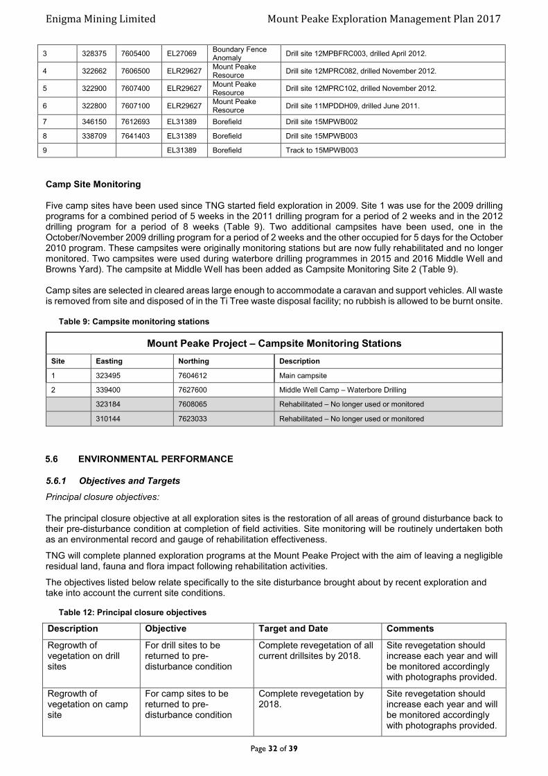
Enigma Mining Limited Mount Peake Exploration Management Plan 2017
Page 32 of 39
3 328375 7605400 EL27069 Boundary Fence Anomaly
Drill site 12MPBFRC003, drilled April 2012.
4 322662 7606500 ELR29627 Mount Peake Resource
Drill site 12MPRC082, drilled November 2012.
5 322900 7607400 ELR29627 Mount Peake Resource
Drill site 12MPRC102, drilled November 2012.
6 322800 7607100 ELR29627 Mount Peake Resource
Drill site 11MPDDH09, drilled June 2011.
7 346150 7612693 EL31389 Borefield Drill site 15MPWB002
8 338709 7641403 EL31389 Borefield Drill site 15MPWB003
9 EL31389 Borefield Track to 15MPWB003
Camp Site Monitoring Five camp sites have been used since TNG started field exploration in 2009. Site 1 was use for the 2009 drilling programs for a combined period of 5 weeks in the 2011 drilling program for a period of 2 weeks and in the 2012 drilling program for a period of 8 weeks (Table 9). Two additional campsites have been used, one in the October/November 2009 drilling program for a period of 2 weeks and the other occupied for 5 days for the October 2010 program. These campsites were originally monitoring stations but are now fully rehabilitated and no longer monitored. Two campsites were used during waterbore drilling programmes in 2015 and 2016 Middle Well and Browns Yard). The campsite at Middle Well has been added as Campsite Monitoring Site 2 (Table 9). Camp sites are selected in cleared areas large enough to accommodate a caravan and support vehicles. All waste is removed from site and disposed of in the Ti Tree waste disposal facility; no rubbish is allowed to be burnt onsite.
Table 9: Campsite monitoring stations
Mount Peake Project – Campsite Monitoring Stations
Site Easting Northing Description
1 323495 7604612 Main campsite
2 339400 7627600 Middle Well Camp – Waterbore Drilling
323184 7608065 Rehabilitated – No longer used or monitored
310144 7623033 Rehabilitated – No longer used or monitored
5.6 ENVIRONMENTAL PERFORMANCE
5.6.1 Objectives and Targets
Principal closure objectives: The principal closure objective at all exploration sites is the restoration of all areas of ground disturbance back to their pre-disturbance condition at completion of field activities. Site monitoring will be routinely undertaken both as an environmental record and gauge of rehabilitation effectiveness.
TNG will complete planned exploration programs at the Mount Peake Project with the aim of leaving a negligible residual land, fauna and flora impact following rehabilitation activities.
The objectives listed below relate specifically to the site disturbance brought about by recent exploration and take into account the current site conditions.
Table 12: Principal closure objectives
Description Objective Target and Date Comments
Regrowth of vegetation on drill sites
For drill sites to be returned to pre-disturbance condition
Complete revegetation of all current drillsites by 2018.
Site revegetation should increase each year and will be monitored accordingly with photographs provided.
Regrowth of vegetation on camp site
For camp sites to be returned to pre-disturbance condition
Complete revegetation by 2018.
Site revegetation should increase each year and will be monitored accordingly with photographs provided.

Enigma Mining Limited Mount Peake Exploration Management Plan 2017
Page 33 of 39
Regrowth of vegetation on access tracks
For access tracks to be returned to pre-disturbance condition
Complete revegetation and rehabilitation by 2020.
This timeframe will increase should erosion remediation measures be required.
Site revegetation should increase each year and will be monitored accordingly with photographs provided.
Erosion of tracks Minimise erosion along access tracks
Nil erosion along access tracks.
March/April each year.
Assess annually and undertake remediation if required.
Persons responsible for achieving objectives:
Mr Kim Grey (Exploration Manager)
The overall objectives for TNG exploration sites are as follows:
To have minimal, preferably zero impact on the environment and minimise pollution.
To continue rehabilitation and monitoring after exploration activities.
Maintain a healthy and safe working environment.
Comply with legal and other requirements and to continue improvement as directed by environmental audits and the Department of Resources, Mining Environment Compliance.
Advance TNG’s staff knowledge-awareness of Indigenous cultural and heritage values through structured
programs.
To protect sacred or significant sites as indicated by Traditional Owners and/or AAPA Clearance Certificates.
5.6.2 Performance Reporting
Completion of rehabilitation of all pre-2015 drilling occurred in November 2015 once the recommendations received from the June 2015 DME Inspection Report were carried out. Rehabilitation activities associated with the 2015 and 2016 waterbore drilling was completed at the end of each programme. Monitoring carried out in March 2016 did not identify any environmental and two campsites, which were only used on one occasion each have been returned to their predisturbance condition and will no longer be monitored. Photographs from the 2015/16 waterbore drilling is included in Appendix 3. No additional requirements have been requested from the DPIR and the sites are rehabilitating well. To date rehabilitation undertaken at the Mount Peake has been successful and objectives and targets are being achieved. Eleven monitoring sites exist across the project area to assess rehabilitation going forward. These sites will be monitored annually and along with the results of any additional audits and inspections will be reported on in the Mount Peake Mining Management Plan each year.
5.7 ENVIRONMENTAL EMERGENCY PROCEDURES AND INCIDENT REPORTING
Environmental incidents and emergencies are defined as, sudden-onset disasters or unplanned events resulting from natural, technological or human-induced factors, or a combination of these, that cause or threaten to cause severe environmental damage.
Most environmental incidents and emergencies involve the release of toxic and hazardous substances into the environment.
Enigma Mining Limited Mount Peake Exploration Management Plan 2017
Page 34 of 39
TNG Limited and its controlled entities are committed to applying best practice environmental procedures at all levels. The procedures described below give an outline as to how to deal with the most likely occurring environmental emergencies along with less serious events. Serious incidents are more likely to happen during a significant exploration drilling programme when drill rigs and support vehicles are on site. Less serious incidents, such as a leakage from a dripping fuel tank etc are still possible during sampling and rehabilitation programmes as have recently been undertaken within the project area. These procedures are not meant to be exhaustive and when dealing with the environment, local conditions should be reviewed and accounted for when making an action plan to deal with any form of pollution or environmental risk. TNG is committed to reporting environmental incidents in accordance with Section 29 of the Mining Management Act (see section 5.7.2). There were no incidents during on site activities in 2016/17.
5.7.1 Spill Containment Procedure
Matter is present in the natural environment in three forms – solids, liquid and gas. Spillage is the event where by substances that do not occur in the local environment are unintentionally released into that area in any of these forms. Containment of spillage of liquids and fluid/solid mixtures is probably the most difficult task to manage and the most common environmental incident. This is because the fluid can spread out more easily than a solid. Hydrocarbons The following procedures for the containment of hydrocarbon spillage such as fuels, oils, solvents, grease etc will be used:
Isolate the source of the spill, report to your supervisor. Contain the spill with bunds. Add litter if soakage rate is slow. Dig up the contaminated area and transport to the designated area. Rehabilitate the area under guidance of your supervisor.
Drill Slurry Slurry release from the drilling plant should have minimal impact as the design is such that a sump will collect these flows or they will be captured within tanks if sumps are not possible. The drill slurry consists of water, added bio-degradable drill mud and drill core cuttings. The slurry is usually allowed to settle and is then recycled and/or released. The sump if used will be rehabilitated at the end of the programme.
The ultimate incident involving slurry will be whereby the bund or sump is exceeded due to the leak going un-noticed for an extended period of time. The drill slurry will not contain any material that will have an adverse impact on the environment however, whenever slurry is released from the drill plant area, or the plant bund capacity is exceeded, the following procedures must be followed:
Attempt to isolate the leak. Shut down the drill plant. Report to your supervisor. If the slurry leak exceeds the outer controls (plant drainage sump, pipe bund)
then the following additional action are required: o Bund the area to stop the spill spreading. o Dig up the contaminated area and transport to the designated area – remove from site. o Rehabilitate the area under guidance of your supervisor.
5.7.2 Incident Reporting
All environmental incidents will be recorded on a TNG Accident/Incident Report Form (Appendix 7) and submitted annually with the MMP. All environment incidents will also be reported to the Mining Compliance division within the Department of Primary Industry and Resources on the Notification of an environmental incident form as per section 29 of the Mining Management Act.
This section describes TNG’s guidelines and accountabilities for all environmental related communication and reporting. Local communities unless otherwise stated generally refer to pastoralists, indigenous groups and their representatives.
Enigma Mining Limited Mount Peake Exploration Management Plan 2017
Page 35 of 39
The objectives of communicating environmental issues include:
Provides access to information from local sources for TNG’s employees, Ensures that employees are aware of, and understand, their accountabilities for environmental management, Facilitates internal TNG reporting, Enables regulatory reporting, Encouraging employee involvement in continuously improving environmental systems and procedures, Providing information on TNG’s environmental performance to the broader community, Addresses environmental concerns of local communities.
TNG inducts its personnel to report all incidents and accidents immediately upon notice to the Exploration Manager or his delegate. A TNG Accident/Incident Report Form is filled out and sent to the Managing Director along with a Notification of an environmental incident form which is forwarded directly to the DPIR Mining Compliance Division.
New employees are briefed on TNG’s environmental systems and procedures during their induction programme. The Exploration Manager will be accountable for ensuring the appropriate induction takes place.
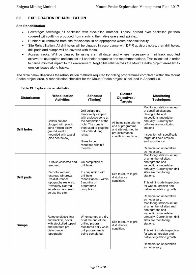
Enigma Mining Limited Mount Peake Exploration Management Plan 2017
Page 36 of 39
6.0 EXPLORATION REHABILITATION
Site Rehabilitation
Sewerage: sewerage pit backfilled with stockpiled material. Topsoil spread over backfilled pit then
covered with cuttings produced from slashing the native grass and spinifex.
Rubbish: all removed from site for disposal in an appropriate waste disposal facility.
Site Rehabilitation: All drill holes will be plugged in accordance with DPIR advisory notes, then drill holes,
drill pads and sumps will be covered with topsoil.
Access tracks: Will be cleared by using a small dozer and where necessary a mini track mounted
excavator, as required and subject to Landholder requests and recommendations. Tracks located in order
to cause minimal impact to the environment. Negligible relief across the Mount Peake project areas limits
erosion issues along tracks.
The table below describes the rehabilitation methods required for drilling programmes completed within the Mount Peake project area. A rehabilitation checklist for the Mount Peake project is included in Appendix 8.
Table 13: Exploration rehabilitation
Disturbance Rehabilitation
Activities Schedule (Timing)
Closure Objectives /
Targets
Monitoring Techniques
Drill holes
Collars cut and plugged with plastic cone >40cm below ground level & mounded with topsoil (also see below).
Drill collars are temporarily capped with a plastic cone at the completion of the hole. The cone is then used to plug the drill collar during rehab. Holes to be rehabbed within 6 months.
All holes safe prior to end of programme and site returned to pre-disturbance condition over time.
Monitoring stations set up at specified sites and photographs and inspections undertaken annually. Currently ten drillsites are monitoring stations Inspection will specifically target drill hole erosion and subsidence. Remediation undertaken as necessary.
Drill pads
Rubbish collected and removed. Recontoured and respread windrows. Pre-disturbance topography restored. Previously cleared vegetation is spread across the site.
On completion of drill hole. In conjunction with drill hole rehabilitation – within 6 months of programme completion.
Site to return to pre-disturbance condition.
Monitoring stations set up at a number of sites, photographs and inspections undertaken annually. Currently ten drill sites are monitoring stations. This will include inspection for weeds, erosion and native vegetation growth. Remediation undertaken as necessary.
Sumps
Remove plastic liner and back fill, cover with stockpiled topsoil and recreate pre-disturbance topography.
When sumps are dry or at the end of the drilling program. Monitored daily while drill programme is being completed.
Site to return to pre-disturbance condition.
Monitoring stations set up at a number of sites and photographs and inspections undertaken annually. Currently ten drill sites are monitoring stations. This will include inspection for weeds, erosion and native vegetation growth. Remediation undertaken as necessary.

Enigma Mining Limited Mount Peake Exploration Management Plan 2017
Page 37 of 39
Tracks/Gridlines
Windrows and piles of dirt from initial track creation respread. Any areas of erosion remediated. Allowed to revegetate naturally. Ripping of tracks if required.
Recontour windrows and dirt piles and conduct erosion remediation in conjunction with drillhole rehabilitation. Ripping may take place (if necessary) when tracks are no longer required or at closure.
Main tracks will be made safe and will remain open and maintained for the foreseeable future. Minor tracks will be left to rehabilitate naturally with the site to return to pre-disturbance condition.
Inspected for safety and erosion. Monitoring stations set up at two sites and photographs and inspections undertaken annually. Remediation undertaken as necessary.
Camp sites
All rubbish collected and removed. Recontoured and respread windrows if required Pre-disturbance topography restored. Previously cleared vegetation is spread across the site.
In conjunction with drillhole rehabilitation.
Site to return to pre-disturbance condition.
Monitoring stations set up at main campsite and photographs and inspections undertaken annually. Remediation undertaken as necessary.
Clarification of drill collar capping and plugging.
Capped at completion of hole. Dug out/cut/plugged during rehab. After rehabilitation.
6.1 Exploration Rehabilitation Register
The exploration rehabilitation registers for the Mount Peake Project area are included as Appendix 9.
6.2 Costing of Closure Activities
The cost of closure activities has been calculated as per the Department Security Calculation Spreadsheet – Exploration Operations Security Calculation Tool which is included as Appendix 10.
The summary table is included below. Currently the DPIR holds $38,393 security against Authorisation 0908-01.

Enigma Mining Limited Mount Peake Exploration Management Plan 2017
Page 38 of 39
10% Discount
Amended amount
1% levy
Contact Name Paul Burton Authorisation # 0908-01
Project Mount Peake Date 5/12/2017
Security Calculation Summary
$31,903.30TOTAL COST
Calculation Trigger
Client Request
Post Closure Management $3,932.00
Sub-Total - All Domains
Calculated Cost
$20,000.00
M & E Security Calculation Tool
Exploration Operations
"ENIGMA MINING LIMITED"
Audit FindingNew AuthorisationMMP
Renewal/amendment
Site Infrastructure
X
Domains
Details
MMP Mount Peake Project Exploration Mining Management Plan Authorisation 0908-01
$3,190
$28,713
$287
$3,810.00Exploration
CONTINGENCY @15%
$27,742.00
$4,161.30

Enigma Mining Limited Mount Peake Exploration Management Plan 2017
Page 39 of 39
7.0 APPENDICES
ATTACHED DIGITALLY