mount rogers - department of conservation and … creek nstate natural area the big survey wildlife...
TRANSCRIPT

Mount Rogers
REGIONComers Rock Overlook in the Mount Rogers National Recreation Area. Photo by Synthia Waymack.
VOP Mapper
Data explorer
M A P I C O N K E Y
3
2013 Virginia Outdoors Plan 10.27 www.dcr.virginia.gov
Introduction The Mount Rogers Recreational Planning Region comprises the counties of Bland, Carroll, Grayson, Smyth, Washington and Wythe, and the cities of Bristol and Galax. The region is in the Ridge and Valley Province and covers 2,782 square miles that stretch from the Appalachian Plateau to the Blue Ridge and from West Virginia to the North Carolina and Tennessee lines. Large tracts of national forest lands, including Mount Rogers National Recreation Area, offer developed campgrounds, picnic areas, miles of hiking, bicycling and horseback riding trails, fishing lakes, trout streams and wilderness. Mount Rogers and Whitetop Mountain are the highest peaks in Virginia, with terrain and habitat features uncommon to other parts of the state and the East Coast. Efforts are increasing to attract tourists to this part of the state as local governments and area businesses join with the U.S. Department of Agriculture Forest Service and the Virginia Tourism Corp. in vacation-planning efforts that highlight area attractions.
The 2010 Census Total Population Maps estimates the Mount Rogers recreation region had a population of 193,595 in 2010, comprising 2.42 percent of Virginia’s population. Continuing with a growth rate of 1.85 percent, the population will be 197,170 by 2020. Growth rates varied across the region from a decrease of 15.35 percent in Grayson County to an increase of 6.88 percent in Washington County. Additionally, the region’s population is aging, bringing new challenges for recreation.
Regional focusThrough the 2011 Virginia Outdoors Demand Survey, input from citizen public meetings and partnerships with local and regional staff, the four priority considerations for the Virginia Outdoors Plan emerged: opportunities for outdoor recreation, economics, health and wellness, and land conservation. In addition to these priorities, valuable information related to regions across the Commonwealth was gained. The following section summarizes regional thoughts and strategies for land conservation and outdoor recreation.
The following was noted during the Virginia Outdoors Plan public input sessions:
Health: The region’s physical inactivity and obesity rankings are among the highest in the state and create concern for public health.
Youth: Public input indicates that connecting youths to outdoor activities is important. Youth hunting is popular. Opportunities exist to increase the use of technology and expand the Appalachian Trail Conservancy’s Trails to Every Classroom program. Family outdoor activities should incorporate social media and other technologies.
Trails: Matthews State Forest single-track mountain bike trails are popular, indicating the opportunity to expand this activity throughout the region. Additional trails are needed for equestrians and ATVs.
Water access: The Blue Ridge Highlands Fishing Trail is a successful model and guide to fishing destinations in Smyth, Wythe, Washington and Grayson counties.
Land conservation: The abundance of open space in this region creates opportunities for land conservation education that will be significantly important to future generations.
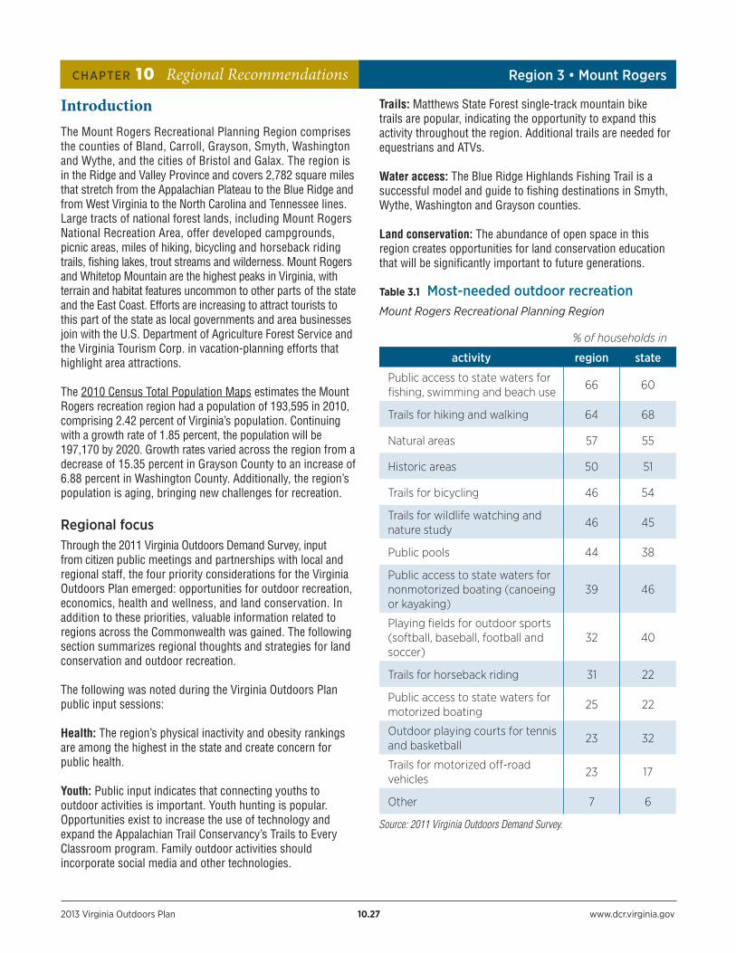
Table 3.1 Most-needed outdoor recreation Mount Rogers Recreational Planning Region
% of households in
activity region state
Public access to state waters for fishing, swimming and beach use
66 60
Trails for hiking and walking 64 68
Natural areas 57 55
Historic areas 50 51
Trails for bicycling 46 54
Trails for wildlife watching and nature study
46 45
Public pools 44 38
Public access to state waters for nonmotorized boating (canoeing or kayaking)
39 46
Playing fields for outdoor sports (softball, baseball, football and soccer)
32 40
Trails for horseback riding 31 22
Public access to state waters for motorized boating
25 22
Outdoor playing courts for tennis and basketball
23 32
Trails for motorized off-road vehicles
23 17
Other 7 6
CHAPTER 10 Regional Recommendations Region 3 • Mount Rogers
Source: 2011 Virginia Outdoors Demand Survey.

2013 Virginia Outdoors Plan 10.28 www.dcr.virginia.gov
CHAPTER 10 Regional Recommendations Region 3 • Mount Rogers
Land conservation Areas in the Mount Rogers region where conservation is being considered:
• The Appalachian Trail Conservancy has identified the Burke’s Garden area in Tazewell County as a high priority for conservation of its scenic views and its importance to the setting of the Appalachian Trail.
• The Virginia Outdoors Foundation is working on a special project area in Grayson County.
Regional and local organizations and agencies should support land protection efforts on priority lands, as identified by conservation partners in the region. Lands for protection may include those located adjacent to rivers and tributaries, national and state park and forest lands, other parks and natural areas, core battlefield areas, properties on the state and national historic registers, and state scenic byways. For more information about prioritizing land conservation, see Chapter 5, Conservation Planning.
Land trusts and conservation programs operating in the region:Appalachian Trail Conservancy, New River Land Trust, Virginia Outdoors Foundation, Virginia Department of Forestry, The Nature Conservancy, Trust for Public Land, and The Conservation Fund.
Map 3.1 Conservation lands
TENNESSEE
WEST VIRGINIA
Bristol
Washington
Grayson
Smyth
Galax
Carroll
Wythe
BlandTazewell
Buchanan
Dickenson
Russell
Pulaski
Radford
Giles
Montgomery
Floyd
Lick Creek StateNatural Area
The Big SurveyWildlife
ManagementArea
George Washingtonand Jefferson
National Forest
George Washingtonand Jefferson
National Forest Judge MatthewsState Forest
Crooked CreekWildlife
ManagementArea
Stewarts Creek WildlifeManagement Area
Grayson HighlandsState Park Big Spring Bog
State Natural AreaPreserve
Blue RidgeParkway National
ParkGrayson Glades
State Natural AreaPreserve
HawksState
Forest
NORTH CAROLINA
Red Rock MountainState Natural Area
Preserve
Clinch MountainWildlife Management
Area
Hidden ValleyWildlife
ManagementArea
The ChannelsState Forest and
Natural Area Preserve
New RiverTrail State
Park
HungryMother
State Park
§̈¦77
§̈¦77
§̈¦81
Patrick
£¤52
£¤21
£¤58
£¤58
£¤58
£¤221
£¤58
Copyright:© 2013 Esri
±
0 5 102.5 Miles
Conservation Lands
U.S. Fish and Wildlife Service
Land Trust / NonProfit Holdings
National Park Service
U.S. Forest Service
Va. Dept. Conservation and Recreation
Va. Dept. Game and Inland Fisheries
Va. Dept. of Forestry
Local Open Space Lands
Conservation Easements
Military Lands
Listed Historic Resources
Battlefield
District
Site
RoadsInterstates
U.S. Highways
Va. Highways
Streams / Water
Jurisdictions
2013 Virginia Outdoors Plan 10.29 www.dcr.virginia.gov
CHAPTER 10 Regional Recommendations Region 3 • Mount Rogers
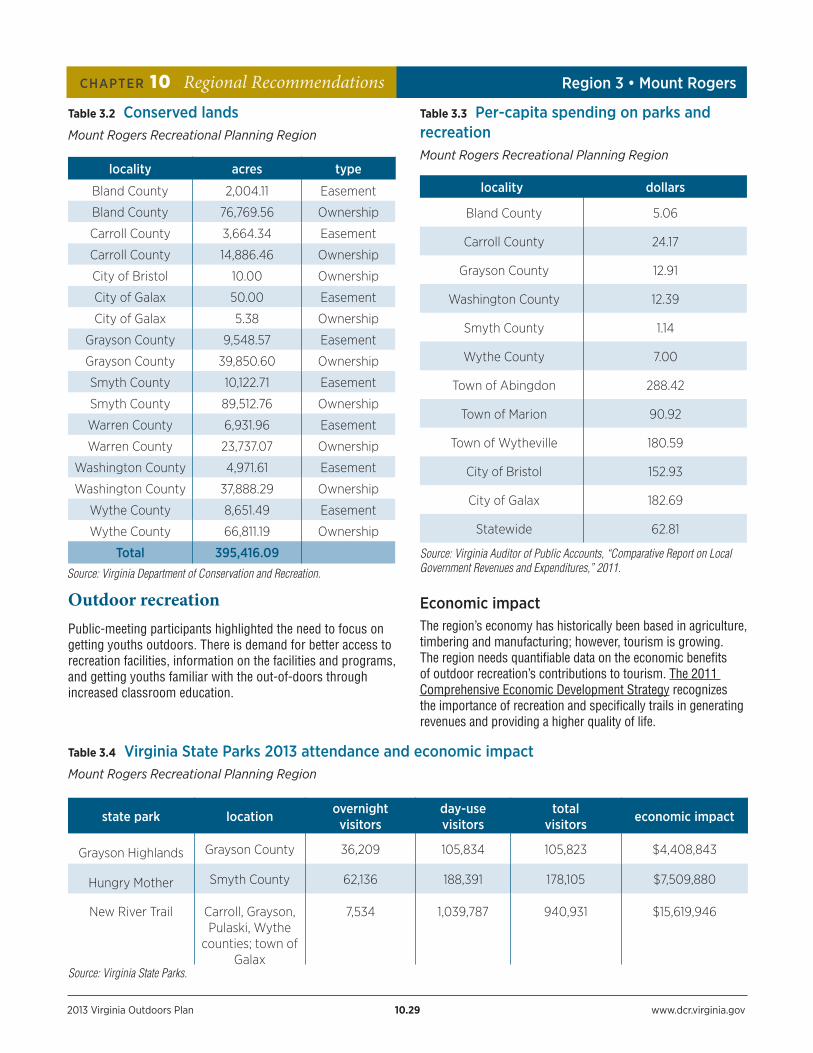
Table 3.2 Conserved lands Mount Rogers Recreational Planning Region
locality acres type
Bland County 2,004.11 Easement
Bland County 76,769.56 Ownership
Carroll County 3,664.34 Easement
Carroll County 14,886.46 Ownership
City of Bristol 10.00 Ownership
City of Galax 50.00 Easement
City of Galax 5.38 Ownership
Grayson County 9,548.57 Easement
Grayson County 39,850.60 Ownership
Smyth County 10,122.71 Easement
Smyth County 89,512.76 Ownership
Warren County 6,931.96 Easement
Warren County 23,737.07 Ownership
Washington County 4,971.61 Easement
Washington County 37,888.29 Ownership
Wythe County 8,651.49 Easement
Wythe County 66,811.19 Ownership
Total 395,416.09
Outdoor recreationPublic-meeting participants highlighted the need to focus on getting youths outdoors. There is demand for better access to recreation facilities, information on the facilities and programs, and getting youths familiar with the out-of-doors through increased classroom education.
Table 3.3 Per-capita spending on parks and recreationMount Rogers Recreational Planning Region
locality dollars
Bland County 5.06
Carroll County 24.17
Grayson County 12.91
Washington County 12.39
Smyth County 1.14
Wythe County 7.00
Town of Abingdon 288.42
Town of Marion 90.92
Town of Wytheville 180.59
City of Bristol 152.93
City of Galax 182.69
Statewide 62.81
Source: Virginia Auditor of Public Accounts, “Comparative Report on Local Government Revenues and Expenditures,” 2011.
Economic impactThe region’s economy has historically been based in agriculture, timbering and manufacturing; however, tourism is growing. The region needs quantifiable data on the economic benefits of outdoor recreation’s contributions to tourism. The 2011 Comprehensive Economic Development Strategy recognizes the importance of recreation and specifically trails in generating revenues and providing a higher quality of life.
Table 3.4 Virginia State Parks 2013 attendance and economic impactMount Rogers Recreational Planning Region
state park location overnight visitors
day-use visitors
total visitors economic impact
Grayson Highlands Grayson County 36,209 105,834 105,823 $4,408,843
Hungry Mother Smyth County 62,136 188,391 178,105 $7,509,880
New River Trail Carroll, Grayson, Pulaski, Wythe
counties; town of Galax
7,534 1,039,787 940,931 $15,619,946
Source: Virginia State Parks.
Source: Virginia Department of Conservation and Recreation.
2013 Virginia Outdoors Plan 10.30 www.dcr.virginia.gov
CHAPTER 10 Regional Recommendations Region 3 • Mount Rogers
The Mount Rogers Planning District is developing and marketing outdoor recreation through partnerships with LENOWISCO, Cumberland Plateau and New River Valley planning districts, and the Friends of Southwest Virginia. According to the Virginia Tourism Corp., domestic travel to the region generated more than $384,255,503 in 2011, or approximately 1.9 percent of statewide travel expenditures. This is an increase of 8.7 percent since 2010.
Appalachian Spring is an innovative partnership promoting tourism, business growth and community development through Southwest Virginia’s world-class outdoor recreation opportunities and natural resources. The Southwest Virginia Cultural Heritage affiliated 501 (c)(3) entity, Friends of Southwest Virginia manages revenues, gifts and grants to Heartwood and distributes financial support to a variety of cultural heritage organizations, such as The Crooked Road and ‘Round the Mountain.
Health and wellness According to the County Health Rankings and Roadmaps program, the percentage of physically inactive adults in this region is among the highest in the state. The region’s percentage of physically inactive adults ranges from 25 percent in Smyth County to 30 percent in Carroll and Washington counties.
Recreation is important for regional populations, particularly for families and children in poverty. Targeted programs for creating healthy living are especially important in areas with high rates of poverty. According to the County Health Rankings and Roadmaps program, more than 10 percent of children in the following counties live in poverty: Bland (18 percent), Carroll (25 percent), Grayson (27 percent), Smyth (28 percent), Washington (19 percent) and Wythe (23 percent), and the cities of Bristol (34 percent) and Galax (36 percent). A limited number of outdoor programs are offered across the region.
Regional featured projects:To be considered a regional featured project, a project must meet at least one of the following criteria:
• Has statewide or regional significance.
• Addresses top statewide or regional needs identified by the Virginia Outdoors Demand Survey.
• Has involvement and support from multiple jurisdictions in the region.
• Is able to be initiated within the next five years.
Featured projects for the Mount Rogers region• Complete connections to the Great Eastern Trail through
the Allegheny and Blue Ridge mountains to link existing trails from central Alabama to central New York.
• Continue to promote and develop the Wilderness Road as it traverses the region, where it is also known as the Frontier Trail.
• The New River Initiative is an integrated watershed protection effort to preserve this American Heritage River— renowned for its wildlife and recreation opportunities. The New River connects six rural Virginia communities that are collaborating with the New River Community Partners to build regional recreation capacity. Collaborative efforts should continue to accomplish regionally significant projects.
• Develop the Salt Trail, a 10-mile rail-to-trail conversion under development between the towns of Saltville and Glade Spring.
• Evaluate the Trans-American Bike Trail (U.S. Bike Route 76) to determine if the trail is still located on the best roads. Recent development has changed traffic levels and some sections of the route carry too much vehicle traffic suitable for Bike Route 76.
• Develop the Mendota Trail along portions of the abandoned Southern Railroad corridor between Bristol and Moccasin Gap.
• Complete a multiuse trail adjacent to Route 52 that connects Bland County to the Appalachian Trail.
Local parks and recreation projects • Continue to develop the Chilhowie Walking Trail.
• Seek funding to develop the Regional Recreational Sports Multiplex, for outdoor sports in Washington County.
• Provide lighting and site improvements for softball, baseball, T-ball and multipurpose sport fields at Beaver Dam Recreational Park in Damascus.
• Improve outdoor recreation and sports opportunities for youths in eastern Washington County.
• Construct the Beaver Dam Creek Trail.
• The Mount Rogers Planning District Commission has plans for streetscape improvements to include biking and pedestrian opportunities in the region’s towns.
• Park facilities could be developed at the Bland County Fairgrounds.
2013 Virginia Outdoors Plan 10.31 www.dcr.virginia.gov
CHAPTER 10 Regional Recommendations Region 3 • Mount Rogers
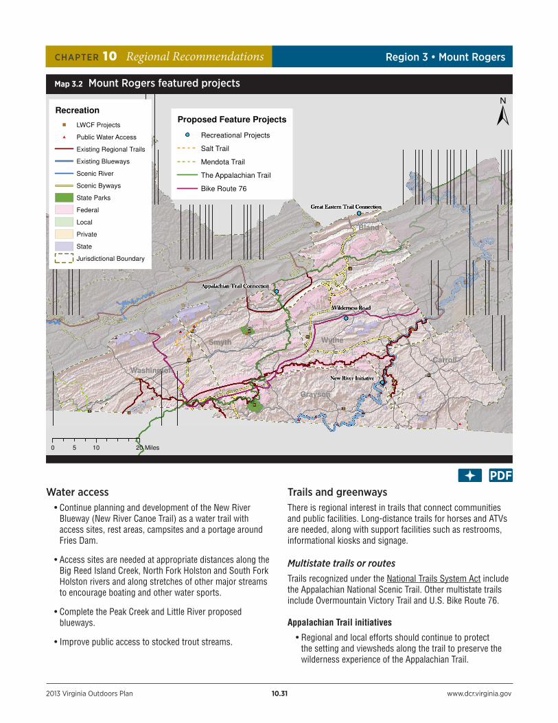
Water access • Continue planning and development of the New River
Blueway (New River Canoe Trail) as a water trail with access sites, rest areas, campsites and a portage around Fries Dam.
• Access sites are needed at appropriate distances along the Big Reed Island Creek, North Fork Holston and South Fork Holston rivers and along stretches of other major streams to encourage boating and other water sports.
• Complete the Peak Creek and Little River proposed blueways.
• Improve public access to stocked trout streams.
Trails and greenways There is regional interest in trails that connect communities and public facilities. Long-distance trails for horses and ATVs are needed, along with support facilities such as restrooms, informational kiosks and signage.
Multistate trails or routesTrails recognized under the National Trails System Act include the Appalachian National Scenic Trail. Other multistate trails include Overmountain Victory Trail and U.S. Bike Route 76.
Appalachian Trail initiatives
• Regional and local efforts should continue to protect the setting and viewsheds along the trail to preserve the wilderness experience of the Appalachian Trail.
Map 3.2 Mount Rogers featured projects
Bland
Smyth
Washington
Wythe
Grayson
Carroll
Recreation
LWCF Projects
Public Water Access
Existing Regional Trails
Existing Blueways
Scenic River
Scenic Byways
State Parks
Federal
Local
Private
State
Jurisdictional Boundary
0 10 205 Miles
Proposed Feature Projects
Recreational Projects
Salt Trail
Mendota Trail
The Appalachian Trail
Bike Route 76

2013 Virginia Outdoors Plan 10.32 www.dcr.virginia.gov
CHAPTER 10 Regional Recommendations Region 3 • Mount Rogers
• Collaborative management of the Appalachian Trail comes in part from Abingdon, Damascus and Bland County, official Appalachian Trail Communities, and the Trails to Every Classroom program.
• Support trail crews to manage the section from Damascus to Route 16 in Marion.
• Protect 260 acres in Smyth County for trail realignment.
Hikers can access the Appalachian Trail year-round from Grayson Highlands State Park. Photo by Irvine T. Wilson.
Statewide trunkline trails• Construct a pedestrian bridge along the New Trail
alignment crossing at Interstate 77.
• Continue development of trails connecting the Appalachian Trail to local communities and trails.
• Provide regional connections linking existing trail systems with the Beaches to Bluegrass Trail. Important local trail components include New River Trail State Park, Virginia Highlands, Iron Mountain, Virginia Creeper and the Overmountain Victory trails.
Regional trails • Bike Trail Link – Connect the Virginia Creeper Trail to a
trail system in Johnson County and Mountain City, Tenn. The first link is from Damascus to Camp Ahistidy. Provide
funding to build and enhance tourism, recreation and economic opportunities.
• Extend the New River Trail State Park to Pulaski.
Bike routes• Continue to develop and promote the Virginia Mountain
Bike Trail. Provide beginner trails and stacked loops to provide opportunities for a variety of skill levels.
• Continue safety improvements and signage to U.S. Bicycle Route 76, which uses routes 80, 91, 58, 603, 16, 601, 614, 749 to Route 11.
• The Virginia Creeper Trail is a 34.1-mile multiuse trail. Prior to 2004, according to the report, The Virginia Creeper Trail: An Assessment of User Demographics, Preferences, and Economics the trail has had positive economic impacts for the town of Damascus and surrounding area.
• New River Trail State Park is a rails-to-trails project stretching more than 50 miles through Grayson, Carroll, Wythe and Pulaski counties.
Other trails • Extend the Wytheville Greenway to Reed Creek.
• Develop trails close to population centers.
Thematic driving toursThere has been tremendous interest in thematic driving tours. These include heritage-based tours, agricultural or product-based tours, and nature-based tours such as the Virginia Birding and Wildlife Trail and Fish Virginia First. Virginia Tourism Corp. maintains a list of Virginia’s scenic drives.
Specific trails that pass through the region include the Crooked Road: Virginia’s Heritage Music Trail, the ‘Round the Mountain Artisan Trail, Fish Virginia First and the Overmountain Victory National Historic Trail.
• Continue to develop the Virginia Cave and Karst Trail.
Historic and landscape resources The 2011 Virginia Outdoors Demand Survey reports that visiting historic sites is the fourth most popular recreational activity in this region. Thus, protecting the region’s historic and cultural resources in their landscape settings is essential to maintaining the quality of life in the Mount Rogers recreational planning region. Local government and local and regional organizations should ensure that countywide historic and architectural resource surveys are completed, especially in Bland and Carroll counties. The region continues efforts to
2013 Virginia Outdoors Plan 10.33 www.dcr.virginia.gov
CHAPTER 10 Regional Recommendations Region 3 • Mount Rogers
recognize and protect historical resources by proactively listing several sites on the National Register of Historic Places.
• The Wolf Creek Bridge, listed on the National Register and located in a public park off Interstate 77 in Bland County, needs funds for maintenance and promotion as a tourist site.
Scenic resources The following scenic resources were identified through Virginia Outdoors Plan public meetings or in collaboration with Scenic Virginia, a private, nonprofit organization that is building a registry of Virginia places of significant scenic beauty.
• Appalachian Trail
• Bland County
• Blue Ridge Parkway, a National Scenic Byway and All-American Road
• Buzzards Rock
• Comers Rock Overlook, the fire tower near Little Dry Run Wilderness
• Hungry Mother State Park
• Powell Valley along Route 23 and the overlook
• Route 77 Hillsville to North Carolina line
• Whitetop Mountain in the Mountain Rogers National Recreation Area
• Wilburn Ridge near Grayson Highlands State Park and Lewis Fork Wilderness
• Grayson Highlands State Park
• New River Trail State Park
• Virginia Creeper Trail
• Mount Rogers
• New River
• National Scenic Areas in Mount Rogers National Recreation Area including Seng Mountain and Bear Creek
Scenic highways and Virginia bywaysThe Virginia Department of Transportation provides information on the Virginia byways Program along with a scenic roads map.
• The Blue Ridge Parkway is one of three designated an All-American Roads in Virginia. It connects Shenandoah National Park with the Great Smoky Mountains National Park in North Carolina. As the nation’s longest rural parkway, it showcases the southern Appalachian Mountains’ diverse history and scenic views.
National forest scenic byways in the region:Big Walker Mountain Scenic Byway
Blue Ridge Parkway
Mount Rogers Scenic Byway
The following road segments are potential Virginia byways and should be evaluated to determine if they qualify for designation:
• Route 75 in Washington County from Abingdon to the Tennessee state line
• Route 58 in Washington and Grayson counties between Abingdon and Volney
• Route 42 in Smyth and Bland counties between Route 16 and the Giles County line
• Route 61 in Tazewell and Bland counties from Tazewell to the Bland-Giles County line
• Route 21 from Wytheville to Speedwell
Scenic riversThere are no designated state scenic rivers in the Mount Rogers region. The following river segments have been evaluated and qualify for Virginia scenic river designation:
• Whitetop Laurel Creek from Green Cove Creek junction in Grayson County to Damascus
• New River from the North Carolina line to Byllesby Dam and from Buck Hydro Dam to Allisonia
• Big Reed Island Creek from Route 753 to New River in Carroll and Pulaski counties
• Walker Creek from Point Pleasant to the Giles County line The following river segments are potential Virginia scenic rivers and should be evaluated to determine suitability for designation:
• The North Fork of the Holston River from the confluence with Big Brumley Creek to the Tennessee state line in Scott County

2013 Virginia Outdoors Plan 10.34 www.dcr.virginia.gov
CHAPTER 10 Regional Recommendations Region 3 • Mount Rogers
• The Middle Fork Holston River from Seven Mile Ford to South Holston Lake in Washington County
• South Fork Holston River from Sugar Grove to South Holston Lake
• Cripple Creek from Speedwell to the New River in Wythe County
• Laurel Fork from the headwaters to Big Reed Island Creek in Carroll County
• Big Brumley Creek from Hidden Valley Lake to its confluence with the North Fork of the Holston in Washington County
There may be opportunities along the New River, a designated American Heritage River, for economic development linked with existing resources, especially the New River Trail State Park. North Carolina, Virginia and West Virginia are cooperating with the National Park Service and the U.S. Army Corps of Engineers to develop a New River Blueway that will provide a series of access points and managed use areas along the river.
Federal programs
National parks • Protect Blue Ridge Parkway viewsheds and adjacent land
use to maintain the park’s long-term viability.
National forests• The U.S. Forest Service should continue to place program
emphasis on congressionally designated areas such as Mount Rogers National Recreation Area, the Appalachian National Scenic Trail and wilderness areas.
• The Forest Service should continue to work with DCR to transfer management responsibilities for the New River Recreation Area in Carroll County adjacent to the New River Trail State Park.
Tennessee Valley AuthorityThe Tennessee Valley Authority (TVA) operates and manages 14 water-access sites on about 44 acres in the Commonwealth along the Clinch, Powell and Holston rivers and on South Holston Reservoir. In 2011, TVA developed a natural resource plan that will guide the authority’s activities and programs for next 20 years, including the recreation management of its resources. The TVA works with the Virginia Department of Game and Inland Fisheries, the Virginia Department of Conservation and Recreation and local governments to implement outdoor recreation opportunities.
• Consideration should be given to the development of formal water trails on the Clinch River to include rest stops, canoe-in campsites.
• Maps for water access and water trails should be developed.
State facilities and programs
State parksA master plan has been developed for the following state parks in this region. The master plan outlines proposed, phased facility development in each park.
Grayson Highlands State Park (4,502 acres) is located in the Grayson County, adjacent to the Mount Rogers National Recreation Area.
Recommendations:
• Upgrade electric and construct two camping cabins in campground.
• Construct picnic shelter near visitor center.
• Expand trail system to connect to points of interest inside and outside the park.
Hungry Mother State Park (3,334 acres) is located in Smyth County.
Recommendations:
• Construct group camp on western side of Camp Burson.
• Construct a foot bridge from eastern side of Amphitheater Island.
• Expand support facilities in environmental education area.
• Expand the trail system.
New River Trail State Park (1,371 acres) is a 57-mile long rail to trail, crossing through Grayson, Carroll, Wythe and Pulaski counties.
Recommendations:
• Renovate the Foster Falls Hotel Complex and parsonage.
• Develop a picnic area at Foster Falls with shelter, rest room and parking.
• Develop Phase 1 recommendations for Horseshoe Bend, Big Reed Island, Double Shoals and Hiwassee Island development nodes.

2013 Virginia Outdoors Plan 10.35 www.dcr.virginia.gov
CHAPTER 10 Regional Recommendations Region 3 • Mount Rogers
• Develop the Mark E. Hufeisen Horse Complex to include include a well and septic system, restrooms, shower and car/spectator parking.
• Upgrade safety at all road crossings.
• Work with Carroll County to close Route 737 from Byllesby Power House to Grayson Station and develop parking and car-top launch.
Lick Creek Natural Area (863 acres) is located in Smyth and Bland counties. The property was acquired in 1961 primarily for its natural beauty and resources. While development of the property is acceptable within the confines of the deed, a limiting factor is public access.
State natural area preserves The Mount Rogers region is a very biologically diverse area of the state. The six highest peaks in Virginia are located in the district and support a variety of plants, animals and communities typical of much more northern parts of the continent. The three forks of the Holston River are home to many rare fishes, mussels and other animals found only in the upper Tennessee watershed. Much of the northern half of the region is underlain by limestone, which is interlaced with caves harboring an assortment of rare animals. The lowlands of Grayson and Carroll counties are dotted with unusual wetlands, which are home to a variety of rare plants and the imperiled bog turtle.
DCR recommends that all unprotected conservation sites, and all unprotected portions of partially protected sites, be targeted for future land conservation. The appropriate method of protection will vary with each site, but may include placing the site on Virginia’s Registry of Natural Areas, developing a voluntary management agreement with the landowner, securing a conservation easement through a local land trust, acquiring the site through a locality or local land trust, dedicating the site as a natural area preserve with the current owner, or acquiring the site as a state-owned natural area preserve.
Conservation targets include:
• Protection of significant caves and karst areas.
• Protection and improvement of water quality for globally rare aquatic communities.
• Protection of significant seepage wetlands in Grayson and Carroll counties.
• Protection of additional lands around Red Rock Mountain, Grayson Glades and Big Spring Bog natural area preserves.
• Establishment of segments of the Virginia Karst Trail on public lands with significant karst areas.
Information about the location of conservation sites and the natural heritage resources they contain, as well as management assistance, is available to local planners from DCR’s Natural Heritage staff. For a discussion of the Natural Heritage Program, see Chapter 9.
Table 3.6 Natural heritage resourcesMount Rogers Recreational Planning Region
Number of occurrences of rare species and significant natural communities
824
Number of different rare species and significant community types (natural heritage elements)
277
Number of globally rare natural heritage elements
139
Number of species listed as federally endangered or threatened
21
Number of species listed as state endangered or threatened
36
Number of conservation sites identified by DCR
141
Number of conservation sites with some protection
72
Number of conservation sites with more than 65% of area with some protection
34
Number of adequately protected conservation sites
16
Data as of July 1, 2012.
Source: Virginia Natural Heritage Program.
Table 3.5 Natural area preserves Mount Rogers Recreational Planning Region
preserve name owner locality
Big Spring Bog DCR Grayson County
Grayson Glades DCR Grayson County
Red Rock Mountain DCR Smyth County
The Channels DOFWashington
County (part)
Source: Virginia Natural Heritage Program.

2013 Virginia Outdoors Plan 10.36 www.dcr.virginia.gov
CHAPTER 10 Regional Recommendations Region 3 • Mount Rogers
State fish hatcheries and wildlife management areas
• DGIF has acquired the 8,300-acre Big Survey property near Wytheville for a wildlife management area. This property has potential for a variety of dispersed recreation opportunities.
State forests Channels State Forest (4,836 acres) in Washington and Russell counties includes 721 acres of the Channels Natural Area Preserve, a 400 million-year-old sandstone outcropping. The forest offers recreational opportunities, including parts of the 14-mile Brumley Mountain Trail that runs from Hidden Valley Lake to State Route 80.
Hawks State Forest (121 acres) in Carroll County is used to demonstrate and manage forest species indigenous to southwest Virginia, wildlife habitat improvement and watershed management. DOF should pursue options for additional access to fully utilize the property resources. Hunting is prohibited on the Hawks State Forest.
Matthews State Forest (566 acres) in Grayson County is managed for a variety of research, educational and recreational uses. DOF should continue development plans for an education pavilion with restrooms and pursue opportunities to acquire easements or fee interests in adjacent properties that could enhance the forest.
Old Flat State Forest (320 acres) in Grayson County is a research forest managed in conjunction with Mount Rogers Area Christmas Tree Growers Association for high-elevation trees. The forest should continue to offer and expand recreational opportunities such as hiking, wildlife watching, biking and horseback riding. Hunting is prohibited on the Old Flat State Forest.
Other state lands• Virginia Highlands Community College in Washington
County has a 100-acre tract with potential for the development of recreational facilities.
Private sector • Private property owners could explore viewshed protection
and possibly public acquisition of Abram’s Falls in Washington County.
Website directoryMount Rogers Recreational Planning Region http://www.mrpdc.org/
U.S. Census Total Population Maps for Virginiahttp://www.census.gov/geo/www/maps/2010pop/2010popmaps.html
Blue Ridge Highlands Fishing Trailhttp://www.fishblueridge.com/
2011 Comprehensive Economic Development Strategyhttp://www.mrpdc.org/docs/CEDS.pdf
Appalachian Springhttp://www.virginiaoutdoors.com/article/more/4104
Friends of Southwest Virginiahttp://www.myswva.org/
County Health Rankings and Roadmaps Virginia Datahttp://www.countyhealthrankings.org/app#/virginia/2012/measure/factors/24/map
Great Eastern Trailhttp://greateasterntrail.net/
National Trails System Act http://www.nps.gov/nts/legislation.html
Appalachian National Scenic Trailhttp://www.nps.gov/appa/index.htm
Overmountain Victory Trailhttp://www.nps.gov/ovvi/index.htm
U.S. Bike Route 76http://www.virginiadot.org/bikemap/
Beaches to Bluegrass Trailhttp://www.dcr.virginia.gov/recreational_planning/tr-sbiib2e.shtml
Publication - The Virginia Creeper Trail: An Assessment of User Demographics, Preferences, and Economics (http://www.dcr.virginia.gov/recreational_planning/documents/userdems_vct.pdf)
New River Trail State Park (http://www.dcr.virginia.gov/state_parks/new.shtml)

2013 Virginia Outdoors Plan 10.37 www.dcr.virginia.gov
CHAPTER 10 Regional Recommendations Region 3 • Mount Rogers
Website directory continued
Virginia Birding and Wildlife Trail http://www.dgif.virginia.gov/vbwt/
Fish Virginia Firsthttp://www.fishvirginiafirst.com/ Crooked Road: Virginia’s Heritage Music Trailhttp://thecrookedroad.org/
Round the Mountain Artisan Trailhttp://www.roundthemountain.org/
Overmountain Victory National Historic Trailhttp://www.nps.gov/ovvi/index.htm Virginia Cave and Karst Trail http://www.dcr.virginia.gov/natural_heritage/karsthome.shtml
Scenic Virginiahttp://www.scenicvirginia.org/
Virginia Byways Programhttp://www.virginiadot.org/programs/prog-byways.asp
Blue Ridge Parkwayhttp://www.nps.gov/blri/index.htm
All-American Roadshttp://www.fhwa.dot.gov/byways/
Virginia scenic rivershttp://www.dcr.virginia.gov/recreational_planning/srmain.shtml
American Heritage River (New River)http://www.14rivers.org/html/mission.html
Blue Ridge Parkwayhttp://www.nps.gov/blri/index.htm
Tennessee Valley Authority (TVA)http://www.tva.com/river/recreation/index.htm
TVA Natural Resource Plan - Overviewhttp://www.tva.gov/environment/reports/nrp/
TVA Natural Resource Plan – Recreation Managementhttp://www.tva.gov/environment/reports/nrp/pdf/finals/nrp_chapter5.pdf
Mount Rogers Area Christmas Tree Growers Association http://www.mtrogersfraserfir.org/
State park master plans http://www.dcr.virginia.gov/recreational_planning/masterplans.shtml
Grayson Highlands State Park http://www.dcr.virginia.gov/state_parks/gra.shtml
Hungry Mother State Park http://www.dcr.virginia.gov/state_parks/hun.shtml
New River Trail State Park http://www.dcr.virginia.gov/state_parks/new.shtml
Virginia’s Registry of Natural Areashttp://www.dcr.virginia.gov/natural_heritage/registry.shtml