multi-disciplinary consultant works … · comprises a propped retained cut between ch 430 ... •...
TRANSCRIPT
MULTI-DISCIPLINARY CONSULTANT WORKS PACKAGE 2
WESTBOURNE PARK AND ROYAL OAK PORTAL
SITE SPECIFIC ARCHAEOLOGICAL DETAILED DESK-BASED ASSESSMENT
Document Number: CR-SD-CT1-EN-SR-00002
Document History:
Version Date Drafted by Authorised by Reason for Revision 1.0 24 Apr 08 Suzanna Pembroke
This document contains proprietary information and may not be reproduced without prior written consent from the executive chairman of Cross London Rail Links Ltd.
Page 1 of 23
Contents
Executive Summary ..................................................................................................................... 4
1 Introduction........................................................................................................................... 5
2 Topography and Surface Geology........................................................................................ 9
3 Aims and Objectives of Assessment .................................................................................. 10
3.1 Methodology ............................................................................................................... 10
4 Results................................................................................................................................ 12
4.1 Map Regression ......................................................................................................... 14
4.2 Truncation Evidence/Disturbance............................................................................... 16
4.3 Discussion .................................................................................................................. 16
4.4 Non-Listed Buildings................................................................................................... 16
5 Recommendations.............................................................................................................. 18
References ................................................................................................................................. 19
Appendix 1 ................................................................................................................................. 20
Appendix 2 ................................................................................................................................. 21
Figure 1. Drawing No. P20103-C1M00-C00-D-00306 from Scheme Design Report Document Number CR-SD-CT1-CE-RT-00010. …………………………………………………………………..6
Figure 2. Drawing NO. P20103-C1M00-C00-D-00307 from Scheme Design Report Document Number CR-SD-CT1-CE-RT-00010.............................................................................................. 7
Figure 3. Drawing P20101-C1M00-G00-D-00201 showing proposed construction and zone of influence………………………………………………………………………………………………… 11
Figure 4. Drawing P20101-C1M00-G00-D-00201 showing sites of archaeological interest…….14
Figure 5. Nearest ground model deposit and archaeological site locations………………………23
Table 1. Map Regression Summary............................................................................................ 16 Table 2. From Scheme Design Report Document Number CR-SD-CT1-CE-RT-00010 non-listed buildings proposed for demolition…………………………………………………………………… 17
Page 3 of 23
Executive Summary
A Detailed Desk-Based Assessment (DDBA) has been carried out on the construction sites identified at Westbourne Park and the Royal Oak Portal as part of construction of Crossrail. The construction sites which have been assessed include:
• Royal Oak Portal and approach Ramp;
• Westbourne Bridge Shaft;
• Paddington New Yard (MDC1) and Paddington Goods Yard (now Paddington Central Development and discussed under that scheme).
The report found that the landscape is likely to have been truncated through surface works associated with construction of the railways to the depth of proposed Crossrail construction works. There are likely to be minimal impacts from road construction work surrounding the site. Archaeological features which may be found are likely to date from the post-medieval period and be associated with railways construction. If associated with Brunel’s work these features will have a moderate to high significance.
The report provides the latest detailed engineering designs (CR-SD-ROP-CE-RT-00002; 21 Dec 07), the earlier scheme design has also been referred to (Royal Oak Portal Construction Volume 2 CD-DV-ROP-X-RT-00016; Jan 08).
Based on the information provided in these reports, works will begin with service diversions and obstruction removals, followed by enabling works, such as site set-up. The western limit of the works lies at the interface with MDC1 located at Ch 225. This corresponds to the western end of the open cut of the portal approach ramp. The Portal structure comprises a propped retained cut between Ch 430 – 510 and an open cut between Ch 230-430. The Westbourne Bridge Shaft will be formed using diaphragm walls over an area of land-surface truncated through rail works and basementing.
The worksites available for supporting the Royal Oak Portal and Westbourne Bridge construction are situated at the eastern end at Paddington Goods yard (Paddington Central Development) and between the portal and shaft construction sites. Currently, the worksite at Westbourne Park (Paddington New Yard) is considered to be the responsibility of MCD1. The impact would be limited, however where deep excavation is required, the impact would be to remove any surviving archaeology.
The likelihood of impacted significant archaeological deposits is viewed as being low.
This and the resulting Written Scheme of Investigation (WSI) will need to be revisited as the scheme design develops and new information comes to light.
Page 4 of 23

1 Introduction
The Cross London Rail Line (Crossrail) is a major new transport link that has been developed to serve London and the south-east of England. The Scheme Design for Royal Oak Portal and Westbourne Bridge Shaft has been developed by MDC2. The details for the Scheme Design for these areas are presented in the following documents:
• Royal Oak Portal and Westbourne Bridge Shaft Construction Planning Report Volume 2 (CR-DV-CT1-X-RT-00029);
• Royal Oak Portal and WBS Option Selection Report Volume 2 (CR-DV-CT1-X-RT-00029).
This detailed desk-based assessment (DDBA) addresses the area (see figures 1 and 2 below) depicted in black and vertical lines below. The extent of assessment for this DDBA stops at the Great Western Road and does not extent any further west. These are:
• An un-propped retained cut between Ch 225 – 320 using a sheet pile wall on the north side;
• An un-propped retained cut between Ch 320 – 430 comprising diaphragm wall on both sides and reinforced concrete base slab;
• A propped retained cut between Ch 430 – 510 comprising diaphragm wall on both sides and reinforced concrete props and base slab. The tunnel eye / portal at Ch 510 which also contains evacuation stairs; and
• A 35.5 m long by 21.9 m wide (internal dimensions) and 19m deep shaft adjacent to Westbourne Bridge at Ch 800.
• Worksites. The worksites available for supporting the Royal Oak Portal and Westbourne Bridge construction are situated at the eastern end at Paddington Goods yard (Paddington Central Development) and between the portal and shaft construction sites.
Page 5 of 23
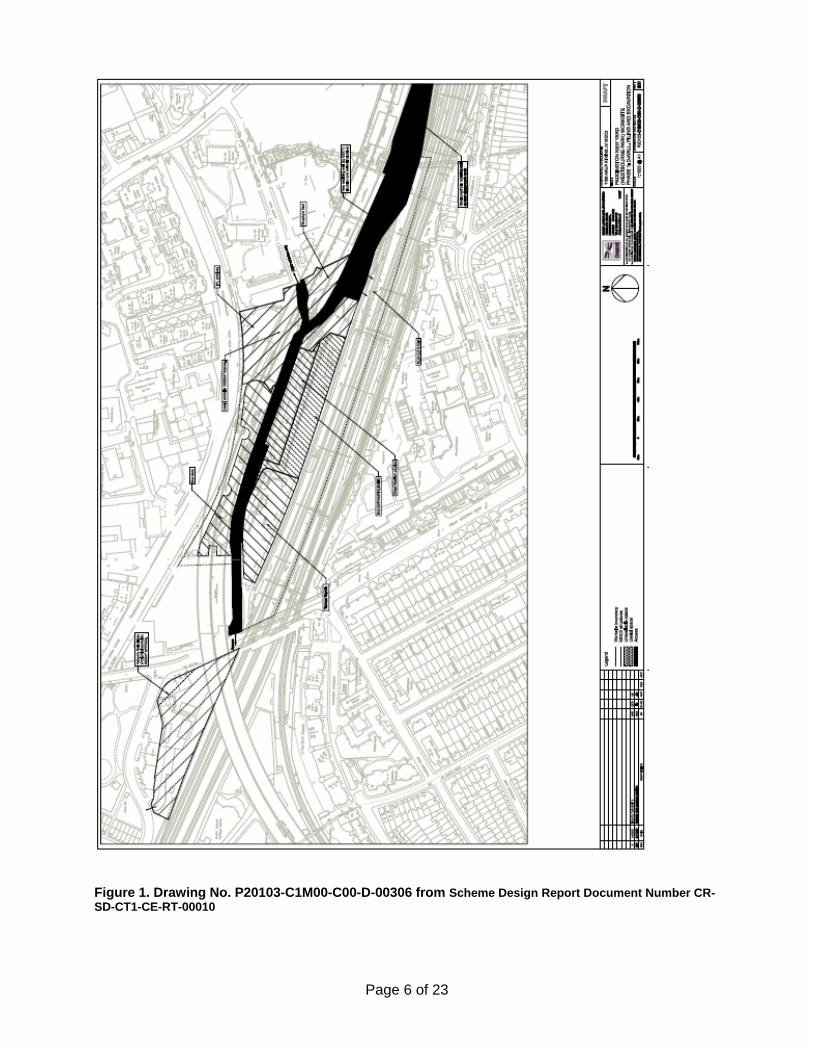
Figure 1. Drawing No. P20103-C1M00-C00-D-00306 from Scheme Design Report Document Number CR-SD-CT1-CE-RT-00010
Page 6 of 23

Figure 2. Drawing NO. P20103-C1M00-C00-D-00307 from Scheme Design Report Document Number CR-SD-CT1-CE-RT-00010
Page 7 of 23

The report comprises the second stage of a process in identifying the presence/absence, location, extent, character, quality and date of any archaeological remains or built heritage features which may be affected by the construction of Crossrail. The first stage comprised a general desk-based assessment of high level data gathering and largely predictive analysis of archaeological potential. That work was presented in the Specialist Technical Reports (STR): Assessment of Archaeology Impacts (Parts 1-6) which were produced in support of the Crossrail Environmental Statement (ES) (2005) and subsequent addenda.
This DDBA represents an additional programme of targeted research and review of documentation. This assessment was required to further define the archaeological potential and site conditions. This DDBA describes the construction impact of Crossrail and its associated works on the archaeological and built heritage (non-listed) resource in support of the production of a site specific site location, proposes mitigation of potential impacts, and provides the scope for a Written Scheme of Investigation (WSI). The assessment has been undertaken for the latest scheme design for the site.
In compiling the DDBA the following assumptions have been made and limitations noted:
• The assessment is based on details as described in Scheme Design Report available at the time of compilation of this report;
• The assessment is based on site conditions as current at the time of compilation of the report;
• The results of the geotechnical investigation, including test pits, undertaken as part of Package 16 have yet to be completed. Only preliminary information has been incorporated into this DDBA.
• No archaeological field survey has been carried out within the site as part of the assessment. An initial site visit was made to understand the general layout and landform of the locality.
A series of documents are being prepared by CLRL in relation to the archaeological works. Where available these have been taken into consideration for the preparation of this DDBA These are:
• Archaeology Generic Written Scheme of Investigation (14022008-44ES-P2Z1)
• Archaeology Project Design: Information Management Plan (in progress)
• Archaeology Procedure for Detailed Desk-based Assessment (in draft)
• Archaeology Procedure for non-Listed built heritage recording (in progress)
• Archaeology Consultation Strategy (in progress)
Page 8 of 23
2 Topography and Surface Geology
This area lies within an area of exposed London Clay. The historic land use has been rural in nature and was owned by the bishops of London. The area was sub-divided and is now the route of the Great Western Railway, and the original route of Brunel’s track. The existing ground level slopes down from the north of the site at c.30.m OD along the towpath of the Grand Union Canal to c.27.4m OD in the Great Western Road to the west of the site, and to c.23.3m OD in Westbourne Park Road to the south of the site.
The majority of the construction sites described above lie within railway cutting, the base of which lies at c.22.5m OD at the north-west, rising slightly to c.23.0m OD to the south and east. There is minimal ground disturbance outside this cutting which has originated from construction of the bus depot, sub-stations, a reservoir and the elevated A40M road deck.
Ground investigation works at Royal Oak Portal have been assessed by MoLAS as part of a watching brief of Package 16 works. Trial pits TP201, 202, 203 were targeted so as to confirm estimated levels of truncation in area of Royal Oak Portal, contributing to archaeological mitigation project design. The watching brief is also concerned with defining the possible survival of the former channel of the Westbourne in the area around Ranelagh Bridge. The results of this watching brief will inform the mitigation of the development at Westbourne Park and Royal Oak Portal construction areas.
Page 9 of 23

3 Aims and Objectives of Assessment
The aims and objectives of this DDBA are to:
• Determine the potential for, and survival of, archaeological resources within the area of Westbourne Park and Royal Oak Portal and associated construction sites, building on information provided during the Crossrail ES stage;
• Provide additional information relating to the archaeological impact of the scheme, based on the engineering design and interpretive site deposit modelling, and to;
• Identify and inform the subsequent phases and scope of archaeological mitigation planning, under a Written Scheme of Investigation (WSI).
3.1 Methodology
The methodology employed for this DDBA was set out in the draft CLRL Procedure for Detailed Desk Based Assessment. The DDBA seeks to define the engineering design information which exists for a specific construction site and to target research on those areas within the construction site which require it. This process identifies changes to the design since publication of the ES. Other associated work activities which have been considered in relation to this DDBA are enabling and utility works and systems and rolling stock works.
Updated baseline information was supplied to MDC2 by the Museum of London Archaeology Service (MoLAS), acting as specialist archaeological advisors to CLRL during the Bill process. MoLAS supplied:
• Updated Greater London Sites and Monuments Record (GLSMR) information;
• Updated information in relation to designations, e.g. World Heritage Sites, Scheduled Ancient Monuments, Local Authority Archaeological Priority Areas, Listed Buildings and Conservation Areas;
• Historic maps of the locality, thus enabling MDC2 to undertake a map regression exercise facilitating a better understanding of the phasing and use of the site;
• A review to archaeological excavations records held at the London Archaeological Archive & Research Centre (LAARC) to provide data on anticipated deposit heights to assist in ground modelling.
This new information was then compared to the Scheme Design engineering and construction information.
A visual site appraisal was made of publicly accessible areas to gain an understanding of the local topography and the construction impact.
Additional documentary sources consulted included where available:
• Historic building records
• Updated technical reports (such as the latest Scheme Design Reports).
Page 10 of 23
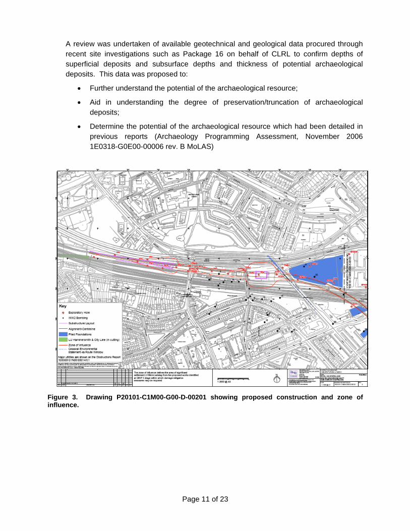
A review was undertaken of available geotechnical and geological data procured through recent site investigations such as Package 16 on behalf of CLRL to confirm depths of superficial deposits and subsurface depths and thickness of potential archaeological deposits. This data was proposed to:
• Further understand the potential of the archaeological resource;
• Aid in understanding the degree of preservation/truncation of archaeological deposits;
• Determine the potential of the archaeological resource which had been detailed in previous reports (Archaeology Programming Assessment, November 2006 1E0318-G0E00-00006 rev. B MoLAS)
Figure 3. Drawing P20101-C1M00-G00-D-00201 showing proposed construction and zone of influence.
Page 11 of 23
4 Results
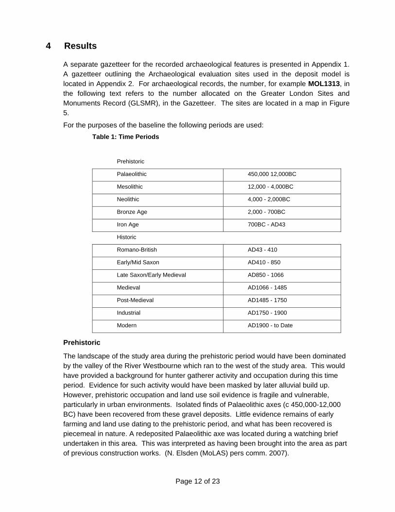
A separate gazetteer for the recorded archaeological features is presented in Appendix 1. A gazetteer outlining the Archaeological evaluation sites used in the deposit model is located in Appendix 2. For archaeological records, the number, for example MOL1313, in the following text refers to the number allocated on the Greater London Sites and Monuments Record (GLSMR), in the Gazetteer. The sites are located in a map in Figure 5.
For the purposes of the baseline the following periods are used: Table 1: Time Periods
Prehistoric
Palaeolithic 450,000 12,000BC
Mesolithic 12,000 - 4,000BC
Neolithic 4,000 - 2,000BC
Bronze Age 2,000 - 700BC
Iron Age 700BC - AD43
Historic
Romano-British AD43 - 410
Early/Mid Saxon AD410 - 850
Late Saxon/Early Medieval AD850 - 1066
Medieval AD1066 - 1485
Post-Medieval AD1485 - 1750
Industrial AD1750 - 1900
Modern AD1900 - to Date
Prehistoric
The landscape of the study area during the prehistoric period would have been dominated by the valley of the River Westbourne which ran to the west of the study area. This would have provided a background for hunter gatherer activity and occupation during this time period. Evidence for such activity would have been masked by later alluvial build up. However, prehistoric occupation and land use soil evidence is fragile and vulnerable, particularly in urban environments. Isolated finds of Palaeolithic axes (c 450,000-12,000 BC) have been recovered from these gravel deposits. Little evidence remains of early farming and land use dating to the prehistoric period, and what has been recovered is piecemeal in nature. A redeposited Palaeolithic axe was located during a watching brief undertaken in this area. This was interpreted as having been brought into the area as part of previous construction works. (N. Elsden (MoLAS) pers comm. 2007).
Page 12 of 23
Roman
The Roman city of Londinium lay approximately 6km to the east of the site. The city was served by a series of Roman roads, two of which are in the vicinity of the site. Bayswater Road is aligned on Roman Stane Street, approaching London from Chichester in the south-west (MLO14883; MLO11208). The area is located to the north west of the Roman road Via Trinobantia (Oxford Street) which ran to the Roman town of Silchester.
Previous archaeological field work and research has determined that there are no Roman known remains in the area and no known deposits in the immediate locality of the study area.
Anglo-Saxon & Medieval
Following the exodus of the Romans from Britain, rural settlement continued and villages such as Paddington and Lillestone to the north east are identified. The land of Hyde Park and surrounding regions, including the Westbourne River formed the Saxon agricultural lands of Eia, which was bequeathed by Geoffrey de Mandeville to Westminster Abbey in 1086.
The medieval village of Westbourne Green was situated approximately 500m to the north-east of the construction area. Westbourne Park was formerly located through the study area.
Post-Medieval
Land use changed dramatically in the post medieval period with economic factors during the Tudor period leading to a population explosion in London. Urbanisation extended out from the City, particularly after the Great Fire of 1666. The suburb of Paddington evolved from a medieval village into a suburb within Central London, situated on the junction of Roman Watling Street and the road to Harrow. During the 16th and 17th century’s it was still a small settlement centred around a village green. In 1756 Marylebone Road was constructed to connect Islington to Paddington and this gave rise to increased housing, commercialism and industrialisation of the area, particularly with the construction of the Grand Union Canal in 1801The area was first impacted upon by transportation requirements as a result of an expanding population. The Grand Union Canal was constructed through to the area in 1801 and Brunel’s Great western Railway was completed in 1840. The rail-line was surrounded by ancillary services and goods yards associated with the maintenance of the line.
Further construction across the study area, as a result of increased urbanism is the Victorian brick Ranelagh sewer which crosses under Ranelagh Bridge. This sewer takes the former Westbourne River underground and was commissioned as part of Metropolitan Board of Works to cover the open sewer as part of improvements to the area in the 1870s (VCA Vol.9:246).
Page 13 of 23

Figure 4. Drawing P20101-C1M00-G00-D-00201 showing sites of archaeological interest
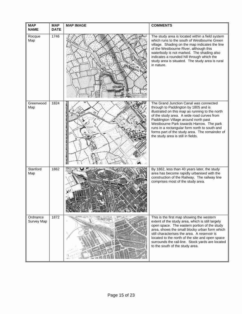
4.1 Map Regression
A map regression exercise was carried out to understand the development of the study area, and to identify any earthworks which would have had a detrimental impact to any earlier archaeology.
Page 14 of 23
MAP NAME
MAP DATE
MAP IMAGE COMMENTS
Rocque Map
1746 The study area is located within a field system which runs to the south of Westbourne Green village. Shading on the map indicates the line of the Westbourne River, although this waterbody is not marked. The shading also indicates a rounded hill through which the study area is situated. The study area is rural in nature.
Greenwood Map
1824 The Grand Junction Canal was connected through to Paddington by 1805 and is illustrated on this map as running to the north of the study area. A wide road curves from Paddington Village around north past Westbourne Park towards Harrow. The park runs in a rectangular form north to south and forms part of the study area. The remainder of the study area is still in fields.
Stanford Map
1862
By 1862, less than 40 years later, the study area has become rapidly urbanised with the construction of the Railway. The railway line comprises most of the study area.
Ordnance Survey Map
1872 This is the first map showing the western extent of the study area, which is still largely open space. The eastern portion of the study area, shows the small blocky urban form which still characterises the area. A reservoir is located to the north of the site and open space surrounds the rail-line. Stock yards are located to the south of the study area.
Page 15 of 23

Ordnance Survey Map
1914
By 1914 urbanisation has encroached through to the west, following the same blocky form of apartments and houses surrounded by linear streets. Much of the open space surrounding the rail-line is becoming developed as goods yards and mileage yards.
Table 2. Map Regression Summary
The map regression exercise demonstrates that until the mid 19th century the area remained in fields and was not extensively developed. The increase of population within London required an upgrade to the existing transport system. The assessment demonstrates that the construction of the Great Western Railway through to Paddington, along with the Canal and road upgrades has had the most impact on the study area. The Ranelagh Sewer is also noted as a significant feature of the area.
The likelihood of the scheme design impacting upon significant archaeological deposits is viewed as being low.
4.2 Truncation Evidence/Disturbance
There is predicted to be limited survival of sub-surface stratigraphy, due to the impacts of the railway and infra-structure development around the construction areas. The location of a redeposited Palaeolithic handaxe derived from earlier construction activities indicates that the site has a history of post-medieval truncation.
4.3 Discussion
There is the potential for enhancing our understanding of early railway construction associated with Brunel’s GWR through a targeted watching brief. Any features associated with this era are likely to be of moderate importance. Archaeological interest is likely to be associated with post medieval industrial archaeology, including construction of the 19th century railway, the Victorian sewer and the relict watercourse of the Westbourne. These are likely to be of low to moderate importance.
4.4 Non-Listed Buildings
Non-listed built heritage requirements are set out in CLRL Information Paper D22 Archaeology and encompasses above ground historic features and structural elements of historical interest.
Two main groups are:
• Non-listed buildings proposed for demolition in conservation areas; and
Page 16 of 23
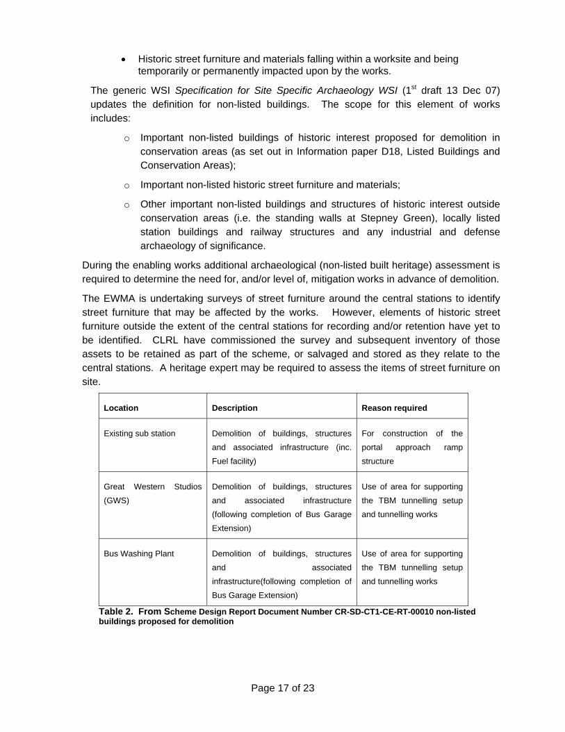
• Historic street furniture and materials falling within a worksite and being temporarily or permanently impacted upon by the works.
The generic WSI Specification for Site Specific Archaeology WSI (1st draft 13 Dec 07) updates the definition for non-listed buildings. The scope for this element of works includes:
o Important non-listed buildings of historic interest proposed for demolition in conservation areas (as set out in Information paper D18, Listed Buildings and Conservation Areas);
o Important non-listed historic street furniture and materials;
o Other important non-listed buildings and structures of historic interest outside conservation areas (i.e. the standing walls at Stepney Green), locally listed station buildings and railway structures and any industrial and defense archaeology of significance.
During the enabling works additional archaeological (non-listed built heritage) assessment is required to determine the need for, and/or level of, mitigation works in advance of demolition.
The EWMA is undertaking surveys of street furniture around the central stations to identify street furniture that may be affected by the works. However, elements of historic street furniture outside the extent of the central stations for recording and/or retention have yet to be identified. CLRL have commissioned the survey and subsequent inventory of those assets to be retained as part of the scheme, or salvaged and stored as they relate to the central stations. A heritage expert may be required to assess the items of street furniture on site.
Location Description Reason required
Existing sub station Demolition of buildings, structures
and associated infrastructure (inc.
Fuel facility)
For construction of the
portal approach ramp
structure
Great Western Studios
(GWS)
Demolition of buildings, structures
and associated infrastructure
(following completion of Bus Garage
Extension)
Use of area for supporting
the TBM tunnelling setup
and tunnelling works
Bus Washing Plant Demolition of buildings, structures
and associated
infrastructure(following completion of
Bus Garage Extension)
Use of area for supporting
the TBM tunnelling setup
and tunnelling works
Table 2. From Scheme Design Report Document Number CR-SD-CT1-CE-RT-00010 non-listed buildings proposed for demolition
Page 17 of 23
5 Recommendations
These recommendations are based on review of previous assessments (Documents 1E0318-G0E00-00006 rev. B; CR-SD-ROP-CE-RT-00002), engineering scheme design and an understanding of archaeological potential and truncation. The requirements for further evaluation have been assessed as regards the programming requirements. Critical Phase archaeological works are required to be undertaken prior to construction works, while Phase 1 works are to be undertaken during the enabling works process, while Phase 2 works are to be undertaken during the main construction works. Phase 3 works comprise post excavation/construction works such as analysis and publication.
Due to the limited nature of archaeological deposits predicted to survive on site, a general watching brief is recommended for all site works across the Westbourne Park and Royal oak Portal construction areas. Archaeological evaluation in this area is defined as being Phase 2 works. A General Watching brief is defined in the Specification for Site Specific Archaeology WSI as:
A programme of observation, investigation and recording during construction activities where remains have not been identified by assessment and evaluation studies but where there remains a risk of archaeological discoveries. In this case the Contractor’s preferred method of working would not be controlled for archaeological purposes, unless important archaeological discoveries are found and the site in question is redefined as a TWB or detailed excavation area.
A survey of the buildings listed for demolition should be undertaken at the earliest convenience so as to record heritage elements before they are demolished.
Page 18 of 23

References
CLRL 2005 Specialist Technical Reports Assessment of Archaeology Impacts, Parts 1-6
CLRL 2007 Archaeology Procedure for Detailed Desk Based Assessment final draft
MDC2 2008 Royal Oak Portal and Westbourne Park Construction Volume 2 CD-DV-ROP-X-RT-00016
MDC2 2007 Royal Oak Portal and Westbourne Park – Scheme Design Report, Vol.3 – Civil, Structural & Tunnel Engineering Report CR-SD-ROP-CE-RT-00002
Museum of London Archaeology Service 2006 Archaeology Programming Assessment ref 1E0318-G0E00-00006 rev. B
'Paddington: Public Services', A History of the County of Middlesex: Volume 9: Hampstead, Paddington (1989), pp. 246-252. URL: http://www.british-history.ac.uk/report.aspx?compid=22673. Date accessed: 18 February 2008.
Whitfield, P. 2006 London: A Life in Maps. The British Library Publishing
Page 19 of 23

Appendix 1
GREATER LONDON SITES AND MONUMENTS RECORD
GAZETTEER OF KNOWN ARCHAEOLOGICAL SITES
GLSMR Easting Northing Type Date Name/ Description/ Location
MLO95865 526095 181559 BLD
Modern to Unknown Westbourne Bridge (road bridge)
MLO96186 526075 181823 BLD 19th Century
British Waterway Canal Office (Office & Toll House)
MLO15326 526005 181805 MON Medieval House at Westbourne Green
MLO25550 526205 181405 MON Post Medieval
Post-med dumping event uncovered at Paddington Goods Yard
MLO3162 526005 181605 MON Palaeolithic
Axe located within redeposited fill in railway cutting
MLO58934 525645 181885 MON Post Medieval Garden located at Senior Street
MLO73253 525704 181605 MON
15th Century to 17th Century Settlement site located at Westbourne Park Rd.
Page 20 of 23
Page 21 of 23
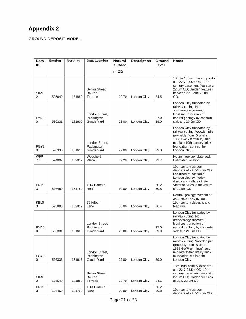
Appendix 2
GROUND DEPOSIT MODEL
Data ID
Easting Northing Data Location Natural surface
m OD
Description Ground Level
Notes
SIR92 525640 181880
Senior Street, Bourne Terrace 22.70 London Clay 24.5
18th to 19th-century deposits at c 22.7-23.5m OD; 19th century basement floors at c 22.5m OD; Garden features between 22.5 and 23.0m OD.
PYD00 526331 181600
London Street, Paddington Goods Yard 22.00 London Clay
27.0-29.0
London Clay truncated by railway cutting. No archaeology survived; localised truncation of natural geology by concrete slab to c 20.0m OD
PGY90 526336 181613
London Street, Paddington Goods Yard 22.00 London Clay 29.0
London Clay truncated by railway cutting. Wooden pile (probably from Brunel's 1838 GWR terminus), and mid-late 19th-century brick foundation, cut into the London Clay.
WFP76 524907 182039
Woodfield Place 32.20 London Clay 32.7
No archaeology observed. Estimated location.
PRT93 526450 181750
1-14 Porteus Road 30.00 London Clay
30.2-30.8
19th-century garden deposits at 29.7-30.6m OD; Localised truncation of London clay by modern drains and cellars of late Victorian villas to maximum of 29.5m OD
KBL03 523888 182912
75 Kilburn Lane 36.00 London Clay 36.4
Natural geology overlain at 35.2-36.0m OD by 18th-19th-century deposits and features.
PYD00 526331 181600
London Street, Paddington Goods Yard 22.00 London Clay
27.0-29.0
London Clay truncated by railway cutting. No archaeology survived; localised truncation of natural geology by concrete slab to c 20.0m OD
PGY90 526336 181613
London Street, Paddington Goods Yard 22.00 London Clay 29.0
London Clay truncated by railway cutting. Wooden pile (probably from Brunel's 1838 GWR terminus), and mid-late 19th-century brick foundation, cut into the London Clay.
SIR92 525640 181880
Senior Street, Bourne Terrace 22.70 London Clay 24.5
18th-19th-century deposits at c 22.7-23.5m OD; 19th century basement floors at c 22.5m OD; Garden features at 22.5-23.0m OD
PRT93 526450 181750
1-14 Porteus Road 30.00 London Clay
30.2-30.8 19th-century garden
deposits at 29.7-30.6m OD;

Page 22 of 23
Data ID
Easting Northing Data Location Natural surface
m OD
Description Ground Level
Notes
Localised truncation of London clay by modern drains and cellars of late Victorian villas to maximum of 29.5m OD
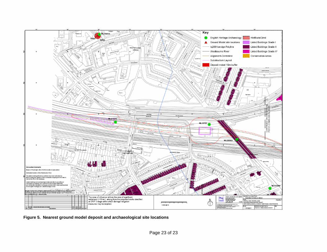
Figure 5. Nearest ground model deposit and archaeological site locations
Page 23 of 23