multi-disciplinary hazard reduction program from
TRANSCRIPT

Multi-disciplinary Hazard Reduction Program from Earthquakes and Volcanoes in Indonesia
Science and Technology Research Partnership for Sustainable Development (SATREPS)
Kenji Satake, University of Tokyo Hery Harjono, Indonesian Institute of Science

Earthquakes with > 1,000 fatalities in last decade Date Region M Fatalities
2011/3/11 Tohoku, Japan 9.0 20,896 2010/1/12 Haiti 7.0 222,570 2009/9/30 Padang, Indonesia 7.5 1,117 2008/5/12 Sichuan, China 7.9 87,587 2006/5/26 Java (Jogjakarta), Indonesia 6.3 5,749 2005/10/8 Kashmir, Pakistan 7.6 86,000 2005/3/28 Sumatra (Nias), Indonesia 8.6 1,313 2004/12/26 Sumatra (Aceh), Indonesia 9.1 227,898 2003/12/26 Bam, Iran 6.6 31,000 2003/5/21 Algeria 6.8 2,266 2002/3/25 Afghanistan 6.1 1,000 2001/1/26 Bhuj (Gujarat), India 7.6 20,023
Of these 12 events, 10 occurred in Asia and 4 in Indonesia

Indonesia and Japan Similarities -Tectonic background: subduction zone -Large population -Need and interest for disaster mitigation Differences -Social and cultural background -Scientific achievements for disaster mitigation
Guntur Semeru
Active volcano M>7 earthquakes since 20th Century

Indonesia and Japan
Researcher’s Committee
Many government sectors involved in natural disaster reduction overarching network is needed (top down, bottom up)
Governmental Committee
Disaster Research Forum
Earthquake and Volcanic Eruption Prediction Consortium
Natural Disaster Res. Consotrium
Indonesia Japan
RISTEK MEXT
DIKNAS MEXT
ESDM METI
DKP MAFF
PU MILT
KOMINFO MIC
DEPDAGRI MIC
LIPI JSPS
BPPT JST
BNPB CO
BMKG JMA
BAKOSURTANAL GSI
LAPAN JAXA
Central Disaster Management Council
Headquarter of Earthquake research Promotion
BNPB

(1) Eq. Forecast (3) Engineering (2) Volcanic eruption (4) Social Sciences
(5) Education and Awareness (6) Coordination with Governments
Multi-disciplinary Hazard Reduction Program from Earthquakes and Volcanoes in Indonesia
Research
Practice
Disaster Risk = Natural Hazard X Society’s Vulnerability
Scientific Observations Infrastructure

Univ. Tokyo
Engineering Social & Cultural Volcanoes Earthquakes
Hazard Vulnerability
Coordination with
Government
Kyoto U. Tohoku U. Nagoya U. Univ. Tokyo
ESDM (PVMBG)
BPPT LIPI ITB LIPI
L I P I (Indonesian Inst. Science)
Joint Coordinating Committee
JICA
RISTEK
ADRC
Education & Outreach
Practice
RISTEK
Project Structure
Univ. Tokyo Earthquake Research Institute
JST

Subgroups Japanese members
Indonesian members
Earthquakes 6 55 29 Volcanic eruptions 4 19 21 Engineering 4 23 15 Social sciences 4 24 13 Disaster education 3 22 27 Total 21 143 105
Multi-disciplinary Hazard Reduction Program from Earthquakes and Volcanoes in Indonesia
Disaster Risk = Natural Hazard X Society’s Vulnerability

Group 1: Earthquake and Tsunami Forecast
Submarine Surveys
Strong Motion
Prediction
Tsunami Simulation
Geodetic Monitoring
Tsunami deposits
Active Faults
Univ. Tokyo and ITB (Bandung Inst Tech)

1-1 Paleoseismicitiy and long-term evaluation of earthquake occurrence of Lembang Fault, West Java
Active fault survey near Bandung ・Fault segment of 27-km long ・Recurrence interval of faulting: 3.5-5.5 ky ・Most recent event occurred 3-5 ky ago Long-term evaluation of large earthquake ・Earthquake magnitude: 〜M 7 ・Earthquake probability: 0.1-5 % in 30 years
Geological section of a fault scarp ・3 colluvial deposits related to faulting ・Cumulative slip: 10-11m since 12-14 ka
Paleoseismicity of the fault
Geometry and displacement along the fault

1-2 Study of historical earthquakes based on tsunami deposit and coastal geology
Tsunami Deposits • Modern and paleo tsunami deposits on west coast of
Sumatra • In Lampuuk, Aceh, two paleo-tsunami layers, inundated
several km, dated between 16th and early 19th C • The 1797 tsunami was large enough to affect the wide
area along the central to northern Sumatra. Coral Drilling • Underwater drilling of massive Porites colony in S. Pagai
Is., Mentaiwai Is., Sumatra, and Simeulue • Clear density bands (annual bands) in coral cores show
environmental changes since 1750’s • Geochemical analysis to reconstruct water depth
changes due to earthquakes Underwater drilling of a coral, X-radiographs. and time series of carbon isotope
The 2004 and paleo-tsunami deposits in Lampuuk, Aceh, Sumatra Is.

1-3 Crustal deformation monitoring using space geodesy and gravity
2005
After 2005
-14.0
-4.7 +8.7
-0.8
+2.8 +15.5
+22.4
+22.4
(1)
(2)
(3)
(4) (5) (6)
Crustal deformation using GPS (1) Post-seismic relaxation of 2004 earthquake in Aceh (2) Shallow coupling and deep slow-slip of Sumatra fault (3) Locking depth of Lembang-Baribis faults in west Java (4) Continuous GPS observations in Aceh and west Java
Gravity surveys in Java Island (5) A10 Absolute Gravimeter in Jakarta, Bandung and
Semarang showed vertical ground vertical motions InSAR analysis
(6) Land subsidence around Semarang area

1-4 Strong motion prediction
(1) Microtremor survey in the Bandung Basin (left) (2) Estimated 3D velocity structure (basement depth, Right).
(5) SAR interferometry and source fault for the 2006 Jogjakarta eq.(top) The slip distribution from seismic and SAR data (bottom)
Strong motion prediction for scenario earthquake in Bandung Basin (1) Microtremor survey at 30 sites in
the Bandung Basin (2) 3D velocity structure model (3) Scenario eq for Lembang fault (4) Strong motion prediction
Verification of source model (5) A source inversion using seismic
and SAR data for the 2006 Jogjakarta earthquake
(4) Strong ground motion of Bandung basin from a scenario eq. on Lembang fault

1-5 Submarine active faults off NW Sumatra
Distribution of active submarine faults, geologically identified from detailed
Thick sediments thrust up on the island arc crust
Tentative correlation of turbidites in the piston cores collected from the Sumatra forearc region
Classification between hemipelagic mud and turbid mud in the Sumatra forearc region
Present distribution and activity of submarine active faults ・ MNBS survey found numerous thrust faults and thrust-related folds parallel trench ・ High-resolution MCS survey confirmed : i. these thrust faults and thrust-related folds were more active toward the trench ii. a thrust (splay) fault in the middle of the outer-arc high was recently active iii. thick sediments were scraped off the oceanic plate and thrust up on the island arc crust Paleoseismology of submarine active faults (1) Turbidites from Sumatra forearc indicate averaged recurrence interval of 330 years (2) Grain composition, grain size, and grain fabric as criteria distinguishing between event
deposits (turbidite mud) and normal deposits (hemipelagic mud).

1-6 Prediction of tsunami using numerical simulation Evaluation of tsunami risk at Pelabuhanratu (1) Bathymetry and topography survey (2) Tsunami run-up simulation of a scenario
earthquake (Mw8.5) off Java (3) Tsunami hazard map by the local
government for evacuation area and evacuation
(4) Results were published in JDR Evaluation of tsunami at Pangandaran and Cilacap (5) Bathymetry and topography surveys (6) Numerical simulation for the 2006 earthquake (7) Tsunami run-up simulation of a scenario earthquake at earthquake at Cilacap
(2) Tsunami simulation
(3) Hazard map

The 2010 Mentawai earthquake and tsunami: Survey and modeling
Tsunami damage (400 death) from M 7.2 earthquake Joint field survey of Groups 1,3 and 6 (2 weeks after eq.) ・Tsunami warning of BMKG did not reach affected coasts ・Tsunami heights: 4 – 7 m ・Weak ground shaking, large tsunami (“tsunami earthquake”) ・Survey results were submitted to UNESCO and GOI Modeling and Simulation ・Max slip ~ 3m near trench axis ・This model produced measured inundation ・The results submitted to international Journal (Pageoph)
Damage in Muntei Measured and computed tsunami Tsunami source model
Measured tsunami heights

Group 2: Volcanic Eruption Forecast
Guntur
Semeru
Batur Tambora
Merapi Kelud
Java Rinjani
Lava dome in Kelud volcano
Eruption of Semeru volcano
Mid- and Long-term forecast and activity monitoring
Short-term prediction and eruption mechanism
Very large eruption: space and temporal distribution
Development of evaluation method of volcanic activity
Kyoto Univ. and PVMBG

GasBurst
Vulcanian Explosion
Tilt observation at Semeru volcano
1. Eruption style Vulcanian explosion Volcano starts to inflate about 200-300s before each eruption. The inflation accelerates with time, suggesting gas volume expansion in magma. Gas burst Volcano constantly inflates about 20s before each burst.
Tilt observation to predict the magnitude and styles of volcanic explosions. Further investigations to improve reliability.
2. Eruption magnitude Large explosions with large seismic follow large inflations.
2-1 Mechanism of volcanic explosion and short-term prediction
The results published in international journals (Bull. Volcanology and JDR)

-7.5
-7.4
-7.3
-7.2
-7.1
-7.0107.5 107.6 107.7 107.8 107.9 108.0
Darajat
Kamojang
MalabarGuntur
Galunggung
Cikuray
Papandayan
2-2 Long-term prediction and tectonics Seismic observation (Guntur, Sinabung) Detection of ground deformation of volcanoes by GPS (Guntur, Sinabung and Merapi) Result and evaluation of volcanic activity ・Seismicity in 3 hydrothermal areas around Guntur ・Detection of inflation of Guntur 5 months before seismic crisis in September 2011 → Repeat of magma intrusion ・No ground deformation at Sinabung → No precursor to magmatic eruption ・Restart of inflation of Merapi after the 2010 eruption → Entering into preparation stage of forthcoming eruption ・Published in JDR Outcome ・Utilized for alert level issued by PVMBG and enhancement of monitoring ・Feedback to prediction and evaluation of volcanoes in Japan
Inflation of Guntur volcano
Hypocenter distribution
Felt earthquake on Sept. 26, 2011

2-3 Geological evaluation of frequency and process
of caldera-forming eruption
2-3-3. Long-term precursor to caldera-forming eruption: Decrease in eruption rate, increase in SiO2 and ratio of explosions (5-10k years before).
2-3-1. Explosive eruptions associated with Batur and Bratan calderas (stratigraphy and 14C dating) Large volume eruptions with pyroclastic flow [5 times in Batur], and [3 times in Bratan] during 29 -6 ka. 10 plinian eruptions of intermediate volume.
2-3-2. Temporal and spatial frequency of caldera-forming eruptions (K-Ar age dating) Bali: Pre-caldera stage active periods at[ ~ 0.5 Ma] and [< 0.2 Ma]. Tengger caldera region: Two caldera-formations older than 0.3 Ma
Multi- caldera
Pre- caldera
Age
Cum
ulat
ive
er
uptiv
e vo
lum
e Output: Review paper, and (in prep.) international papers Outcome: Capacity building in field survey, and contribution to hazard mitigation for global eruptions in WS (G-EVER 1) Evolution of caldera volcano

2-4 Evaluation of volcanic activity and proposal
0
100
200
300
400
1990 1995 2000 2005 2010
0
100
200
300
400
500
600
0
100
200
300
400
500
600
1900 1920 1940 1960 1980 2000
Investigation of volcanic activity of Kelud volcano in the past and at present Joint report of G2-4 and G4-4 to two regencies around Kelud volcano Evaluation of volcanic activity of Kelud ・Lava dome extruded by the 2007 eruption was much smaller than the volume expected from magma production rate in the 20th century ・Number of volcanic earthquakes after the 2007 eruption has turned into increase in 2010. →Magma supply and storage has already started, and Kelud volcano may erupt in a decade. Proposal Eruption scenarios, volcano monitoring and countermeasure s to mitigate volcanic disaster to ward eruption in near future are explained to PVMBG and two regencies. Published in JDR
Cumulative mass of magma ejected by eruptions at Kelud volcano
×109 kg
1990Eruption
2007Eruption
Annual number of earthquakes
2007Eruption

Quick response to 2010 Sinabung & Merapi eruptions
・Sinabung: experts, geophysical observation (6 seismometers, 4 GPS), geological survey and dating ・Merapi: experts, observation (4 GPS), ion-chromatograph, collaboration of JDR team Observation results and evaluation ・2010 eruption of Sinabung is phreatic. ・History of eruptions and eruption scenario ・ No ground deformation at Sinabung → No precursor to magmatic eruption ・Merapi: Drastic change of chemistry of deposits between October and November→Change in conduit system and long-term activity ・ Restart of inflation after the 2010 eruption → Restart of accumulation of magma Outcome ・Utilized for alert level issued by PVMBG and enhancement of monitoring ・Report to vice-president of Indonesia Restart of inflation of Merapi
SiO2-K2O diagram for Sinabung product
Volcanic ash in 2010
GRWH-KLAT
GRWH-DELS
DELS-KLAT

Group 3: Engineering Approach for Reducing Vulnerability
3-1 Effective use of tsunami hazard map Official hazard map in Padang 3-2 Coastal vegetation for tsunami Tsunami forest: field test, lab test, simulation 3-3 Liquefaction mitigation Ground condition measurements Liquefaction hazard maps 3-4 Building code and retrofitting bldgs PP band method
Tohoku Univ. and BPPT

3-1 Effective use of tsunami hazard map
Padang: Seismic gap Tsunami hazard maps made by various agencies 6 kinds Discussion for official hazard map 2009 Padang earthquake (depth 80 km, 1000 deaths) - Many tsunami evacuation buildings were collapsed - New tsunami evacuation buildings were assigned - Evacuation index: evacuation capacity based on flow speed and arrival time
Heavily damaged in 2009 Tsunami evacuation bldg

Measuring force and slope
Measuring size of trees
Hydraulic experiments
1 month
1 year
3-2 Reduction of tsunami damage through the practical use of vegetation
(1) Field test at Pariaman • Casuarina • Measurements of felt trees
(2) Indoor experiments at BPPT • Measurement of bore typed tsunami
(3) Numerical analysis of green belt • Guidelines
(4) Tsunami surveys in Mentawai • Tsunami damage and effects of trees

3-3 Technology development for mitigating hazards due to liquefaction
In Bantul and Padang ・Microtremor measurements ・Geotechnical drilling ・Liquefaction from 2009 Eq. Liquefaction potential map

3-4 Investigation of design ground motion and implementation of earthquake safer housing by both
technological and social approaches In Padang (1) Subsurface structure and predominant period
based on microtremor measurements (2) Proposal of design response spectra
Technology transfer of retrofit method PP band Bamboo mesh
Predominant period at Padang
Design response spectra
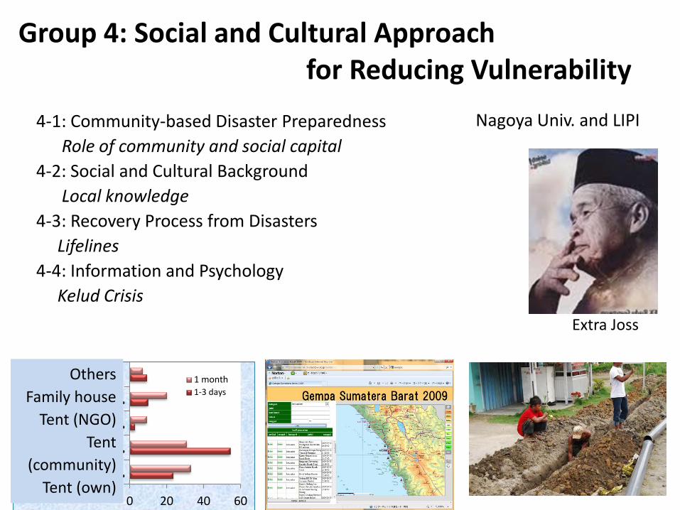
Group 4: Social and Cultural Approach for Reducing Vulnerability
4-1: Community-based Disaster Preparedness Role of community and social capital 4-2: Social and Cultural Background Local knowledge 4-3: Recovery Process from Disasters Lifelines 4-4: Information and Psychology Kelud Crisis
0 20 40 60
Tents…Tents…Tents…
Family…Others 1 month
1-3 days
Others Family house
Tent (NGO) Tent
(community) Tent (own)
Extra Joss
Nagoya Univ. and LIPI

4-1 Community-based disaster preparedness Recommendations • A little community approach especially in the preparedness phase • Disaster management scheme should be local, paying attention to nature of
hazard, and based on social/geographical conditions, in bottom-up style • Networking mechanism between government and community at regional
level, with an intermediate organization including university as a facilitator • Social sciences on natural disaster are still underdeveloped, and should be
supported by continuing international academic exchange Collaborative Research in Ache and Yogyakarta • Preliminary evaluation about community functions Outputs • Collaborative Volumes of Research Papers (2009-2011: Above right) • Workshop dissemination of fieldwork results (2011: Below right) • Orang orang yang bertahan dari tsunami (2011: Right) • Community approach to disaster (Forthcoming)
Community function Intermediate Aggregate Education
Preparedness × × ×
Emergency response × △ ×
Reconstruction ○ △ △
Note: ○△× Intensity of function; ■■ Degree of expectation

4-2 Information mapping system on disaster and society
Created and Released the Information Mapping System on Disaster and Society (pic.1)
• To grasp overall picture of disaster afflicted area through online mapping system
• By collecting online articles of Indonesian newspapers on disaster immediately after disaster
• By automatically categorizing articles by themes and locations and locating the articles on maps
• Images, field notes, manuscripts and other types of information can also be added
• For information gathering for relief aid, and archiving the rehabilitation and reconstruction process etc.
• For promoting disaster tourism and social alert (minor disasters as early warning for social instability)
Workshop for technology transfer of the system
• To the Governor of Aceh and state agencies (education, tourism, development and statistics)
Findings shared with society by TV and radio programs
Information Mapping System on Disaster and Society
Workshop at Banda Aceh in Dec. 2012 (5 days, 44 papers, total 600 participants)

4-3 Long term recovery
Outcomes • Sharing outputs about the 2004 Indian
Ocean Tsunami Research • Sharing techniques for long term
recovery research • Collaborative survey about long term
recovery process from the 1995 Kobe Earthquake and the 2004 Indian Ocean Tsunami
• Survey on recovery process of water supply system in Banda Aceh
• Sharing information about recovery studies about the 3.11 East Japan Earthquake Disaster
• Development of recovery process data sets from the 2004 Indian Ocean Tsunami in Banda Aceh
Common Framework of Recovery Process
Recovery Process from the 2004 Indian Ocean Tsunami in Banda Aceh

Results and Recommendations ・ Evacuation rate: 52.9% (Kediri Regency) 87.1% (Blitar Regency) ・ A critical role played by leaders of villages (desa/ dusun) for information dissemination. ・ A variety of information dissemination tracks is essential. ・ Technical terms are required to be reviewed by PVMBG. ・ Legally including the mass-media into the disaster management system is necessary. Ex. “Designated Public Corporations” in Japan
3.2%
32.9%
20.4%
23.1%
6.0%
4.6%
2.8%
3.7%
3.2%
1.9% 25.1%
19.9%
28.0%
9.0%
9.0%
6.6%
0.0%
0.5%
2.6%
29.0%20.1%
25.5%
7.5%
6.8%
4.7%
1.9%
1.9%
0.0% 10.0% 20.0% 30.0% 40.0%
Family
Desa/dusun leader
Local government
PVMBG staff
Informal leader
TV or radio
Other
I don't know
No Answer
Kediri (N=216)
Blitar (N=211)
Total (N=427)
4-4 Warning dissemination and residents’ psychological process under natural disasters
Aim Requirements for development of a more suitable warning system. Methods ・ Case study: Volcanic eruption of Mt. Kelud in 2007. The volcanic alert level reached the highest level 4 (AWAS) The evacuation order has been issued. ・ Group-interviews to the affected people. ・ Mass-survey: Two-step random sampling. N=427 (Valid response rate: 94.9%)
Trustiness of information source
Possession Rate
Kediri Blitar Lowest Highest Lowest Highest
TV 83.7% 97.7% 56.1% 82.5% Radio 32.6% 65.1% 36.6% 90.2% Handy phone 48.8% 77.3% 35.0% 62.2%
Local difference: communication media

Group 5: Disaster Education Promotion and Disaster
Consciousness
G5-2 Collection and Transfer of Disaster lessons
G5-3 Development and Testing of Disaster Education Materials on the Internet
G5-1 Education, Outreach and Capacity building
5-1-3 Effective Disaster Education Material and City Planning Tool
5-1-1 Effective disaster education at school 5-1-2 Disaster Awareness Upgrading Program using People’s Participatory Approach
5-1-4 Visualization of Disaster Hazard and Sharing of Disaster Awareness
Fuji Tokoha Univ., Univ. of Tokyo , LIPI

5-1 Education, outreach and capacity building 5-1-1 Effective Disaster Education at School 5-1-3 Effective Disaster Education
Material and City Planning Tool
5-1-4 Visualization of Disaster Hazard and Sharing of Disaster Awareness
3. School Initiative Operation of Disaster Education Program
5-1-2 Disaster Awareness Upgrading Program using People’s Participatory Approach
1 Development and Transfer of Disaster Town Watching to understand Risks
3 Research on Disaster Terminology
2 Web base Disaster Education Material Database
Development of Dynamic Simulation of Tsunami and Evacuation
• Simulation of Tsunami and Evacuation
• Interactive Function by User
• Tsunami at Aceh by Sumatora Earthquake
1. Disaster Education using Tsunami Memorial Pole 2. Disaster Awareness through Museum Exhibition 3. Flower Massage Exhibition 4. Map of Monuments of Sanriku Tsunami of 1896 and 1933 for transfer Lessons learned Padan
Tohoku Survey of Tsunami
Monuments at Aceh
Aceh
教訓の共有と連携
More than 50,000 Flower at Aceh
博物館展示
1. Collaboration with national/local organization and institution 2. Pilot lesson and Developing education Guidebook
Disaster education activities (by TDMRC) Evacuation drill
Pilot lessons for teachers and students Guidebook
Townwatch Mark on Map Solve Problems Report

Collecting and Verifying 2004 Aceh experiences
5-2 Research on effective methodology for collecting and diffusing of disaster lessons
Workshop with prototype drill book
Joint survey of 2010 Mentawai slow event (Indonesian researcher and painter with Japanese researcher)
(Oct., 2010)
Workshop based on evacuation stories in Aceh, Mentawai and Japan
(Feb., 2012)
Yogyakarta
Jawa Barat

5-3 Development and testing of disaster education materials on the Internet
• Able to participate at any place without attending on site • SOI Asia Project (School on Internet Asia,) system • Widely covered of Asia region including Indonesia, Japan • Connects to Indonesian Research and Education Network (INHERENT)
1. Develop and Implement of Internet based distance education system 2. Delivered International Workshop and Lectures of Disaster Education
• 2009.4.21 “Multi-disciplinary Hazard Reduction Program from Earthquakes and Volcanoes in Indonesia Kick-off Workshop”
• 2009.10.12,13 “ International Workshop on Multi-disciplinary Hazard Reduction from Earthquakes and Volcanoes in Indonesia and Beyond”
• 2010.2.23-3.8 “Technical workshop for Indonesian distance learning environment operators “
• 2010.7.12-14 “International Workshop on Geodynamics and Disaster Mitigation of West Java”
• Ask lectures of this research output by this project
• Deliver these lectures to Indonesia and south east Asian countries through distance education system
Distance International Workshop Prepare and Distribute Distance Education Lectures

Group 6: Coordination with Governments
Activity within the project -Annual multi-disciplinary workshop -Group leader meetings and JCC -Inter-group meetings/discussion -Publication of JDR special issue
Outreach Activities -Newsletters -TV program (IPTEK Talks) Institutional Activities -Recommendation at 2011 workshop -Papers on policy aspects of 2010 Mentawai tsunami and 2011 East Japan earthquake -Visit and discussion at Central Disaster Management Council and Headquarters of Earthquake Research Promotion
ADRC and RISTEK

Exchange of Researchers
FY Persons Days
2009 Japanese visit Indonesia 90 905
Indonesian visit Japan 14 187
Graduate Student Fellowships 2
2010 Japanese visit Indonesia 100 959
Indonesian visit Japan 56 558
2011 (-Jan)
Japanese visit Indonesia 87 751
Indonesian visit Japan 23 216

Meetings and Workshops 2009-2010
April JCC, Kick-off workshop (Bandung)
October International Workshop (Banda Aceh)
March JCC, Group Leader Meeting (Jakarta)
2010-2011
May JpGU, Group Leader Meeting (Chiba)
July International Workshop (Bandung)
November International Workshop (Kobe)
2011-2012
May 6 JCC, Group Leader Meeting (Jakarta)
May JpGU, Group Leader Meeting, Sendai trip
October Final Workshop (Jakarta)
March Joint Workshop with Philippine Project, Sendai Symposium

Plan of Operations

Outputs Japanese International (English)
Original papers 38 53
Reviews or articles 18 12
Invited talks 3 10
Oral presentations 47 85
Poster presentations 15 25
J. Disaster Research (Open-access refereed journal) 1st issue of 2012 (Vol. 7 No.1) Special issue for this project 10 original papers and 2 review papers
Within project Open to public
Project 11 (incl. JCC) 5
Each group 5 56
Workshops

J. Disaster Research

Media Coverage Japan Indonesia
Awards 5 8
Newspaper 17 56
TV / Radio 6 7
- Emergency rescue team for Merapi volcano (Japanese govt) - J-RAPID (JST, joint survey for East Japan Eq. and Tsunami) - Consulting research from pertroleum company - Information mapping system - Tsunami evacuation simulation system (RISTEK project)
Examples of Outcomes

Summary 1. A pilot project of SATREPS 2. Joint surveys and research between Japan and Indonesia
- Many papers and presentations - Technology transfer, capacity building 3. Inter-disciplinary and inter-institutional collaboration - Natural sci., engineering, humanities and social sci. - Collaboration across universities and govt agencies 4. Coordination of researchers, govt. and local people - Disaster education (research and practice) - Knowledge transfer - Proposal of convert JCC to a permanent committee 5. Urgent and flexible response to recent disasters - 2009 Padang earthquake, 2010 Mentawai eq. - 2010 Sinabung and Merapi eruptions