multimodal transport axis design. analysis of critical
TRANSCRIPT

Multimodal Transport Axis Design. Analysis Of Critical Matters Depending
On Railway-Motorway Closeness
Andrea Capra DIIAR - Politecnico di Milano
Tullio Giuffrè
DIIAR - Politecnico di Milano
Savino Rinelli DIIAR - Politecnico di Milano
Synopsis Planning an integrated network of European transport infrastructures (multimodal transport axis or corridor), where both transport lines and junction coexist, problems related to the connection of pre-existent infrastructural and natural networks aren’t often duly evaluated. This consideration moves from Authors’ design experiences on many segments of AV/AC railways in the North of Italy. These experiences showed involvements and consequences of preliminary layout and alignment choices on complementary works, the role of which is very important to solve the interference between the pre-existent networks and the new infrastructures system, for example the road and hydraulic ones. Design problems, building costs and relevance of complementary works are often comparable or even more than the ones concerning the new axis infrastructures. In this way, the corridor layout is a determining factor. Infrastructures layout distance (i.e. railway and road), project level design and altimetric offset are the main parameters which constrain design of cross constructions, environmental mitigation works and safety systems, with implications on environmental impact and costs. That is why consequences of the axis infrastructural choices can be sometimes worse than the expected ones. Trying to orientate design choices, and also to make Public Administrations aware of the consequences depending on general setting-out criteria, the present article takes in exam a case study in advanced planning stage. It analyzes the main critical matters due to corridor construction and highlights for each of these both the most influencing parameters on design scenario and the different options design effects.

Multimodal Transport Axis Design. Analysis Of Critical Matters Depending
On Railway-Motorway Closeness The expression “multimodal corridor” appears in Italy in the "Piano Generale dei Trasporti" in 1984. There with the expression multimodal corridors some axis were identified along which it can be developed, in terms of national and international networks, a great integration among the different transport modalities, through interchange nodes (railway stations, ports, airports, transhipment ports). The presence of highly structured urban systems and the geomorphology of the territory brought to detect, at that time, some multimodal corridors as lead lines of the entire national transport system:
- along the E-W direction, the lead line at the base of Alps, in close connection with the urban system Turin – Milan – Brescia – Verona - Pordenone- Udine;
- along the N-S and NW - SE direction, the two great axis “tirrenico” (Ventimiglia – Genoa - Florence – Rome - Naples - Reggio Calabria - Palermo - Trapani) and “adriatico” (Milan – Piacenza – Bologna – Rimini – Ancona – Bari - Lecce);
- along the N-S direction, along the ridge connecting Rome to Brennero (through Florence, Bologna, Bolzano) and Tarvisio (through Venice).
In the same way a sixth corridor was identified for the relationship between Sardinia and the continent. Starting from PGT hints, the concept of multimodal corridor has become more and more specialized in relation with planning activities and assuming the meaning of group of transport infrastructures highly integrated and organized as a system. In this way, the localization of multimodal corridor becomes the tool through which, in close relation with developing politicy of the served or crossed territories, all the transport connections can be re-organized, fully capitalizing the advantages of each modality. This is why the works necessary to the realization of multimodal corridor (new realizations or improvements of existing infrastructures) are considered strategic and have a program priority. According to the above considerations, the works of the multimodal corridors can be placed for the improvement of SNIT (Integrated National Transport System) scheduled by the updates of PGT and by the connected economical planning documents (PGTL 2001, PON Trasporti 2000 - 2006, etc.). The idea of multimodal corridor increases its strength in the improvement perspective of the trans European transport networks (TEN-T: Trans European Network - Transport), for which since 1994 (European Council in Essen) European and national working teams have identified 30 infrastructural projects of pre-eminent community interest, to which it has been assigned the function of pan European multimodal corridor (Decision n. 1692/96/CE, Decision n. 1346/2001/CE, Decision n. 884/2004/CE). Aside from the general targets above recalled, the realization of a multimodal corridor reconnects itself to one ore more of the following strategies:
- to strengthen and to improve inter-connection of transport networks at local level, enhancing the quality of transportation services and increasing the use of existing transport infrastructures;
- to strengthen nodes and terminals connections at local level with trans national networks, to facilitate the flow of goods, financial resources and human capital (with particular attention, especially in goods area, to the connection between equipment and articulation of infrastructures – networks and interchange nodes – and quality and arrangement of supplied services);
- to realize and to adjust the nodes connections to the national and the international networks (connections between cities and airports, connection of highly developing areas with national railway network), respecting targets of pollution reduction and minimization of environmental impacts;
- to follow the modal balance both on urban and metropolitan viewpoint (mass transport infrastructures in fixed seat) and on goods transport viewpoint (by railway, in the definition of itineraries and interchange nodes; by sea, improving the infrastructure for cabotage).
Without rejecting the positive value of the multimodal corridor idea, its realization from the project point of view can highlight an hardly sustainable impact on the interested territory, to the point of generating great objections by local communities. From these instances depends the need of mitigation and complementary works, the main purpose of which (not always declared) is to obtain the approval on the multimodal corridor project through a real compensation.

This is a consequence of the multimodal corridor idea itself, whereas the objectives of containing the territory consumption and the concentration of interferences with existing infrastructural networks (not only the transport one) necessarily lead to forced co-existence of new infrastructures in small space and, in the case of linear infrastructures, to increase criticalities related to the territorial insertion (connection to intermediate road network, re-connection of local roads and hydraulic network, etc.). It has to be observed that the more the condition of co-existence becomes constraining (little inter-axis distance between the corridor infrastructures), the more specific criticality could raise during the design phase due to mutual inter action in the operation of different transport modalities (both because of functional matters, safety of working and works of maintenance). From that above, it emerges how the corridor design, more than in case of a single infrastructure design, is characterized by a searching of solutions that, case by case, allow to reach the best compromise between territorial, functional and environmental requirements which can indicate strongly antithetic choices because of dimension of works and of constraints (technical and administrative). In the way to address the designer in this delicate duty, but also in order to make Public Administrations aware of consequences depending on multimodal corridor general setting-out criteria, the present paper focuses on main crucial design problems, pointing the impact of different design options for each of them. This was deepened through a case study in advanced planning stage, which allowed to analyze a wide and a diversified case history of problems proper of the design of a corridor made up by road and railway infrastructures. THE CASE STUDY According to the aims of the present study, the observations given below moved from Authors’ design experiences on many segments of AV/AC railway axis Turin – Milan - Verona. It is including on V multimodal axis European project, also called “Integrated System of Southern Europe direction East – West”, from Lisbon to Kiev. Parallel to the development of the railways system – both nodes reorganization (transhipment port and inter-modal terminals) and new line construction (AV/AC railway) and traditional lines capacity level increase – many road interventions have been foreseen, both nodes (Milan and Brescia cities new bypass system) and new roads construction (“Pedemontana Piemontese – Lombard – Veneto connection, Malpensa airport highways connection). The interest for this case study derives from new multimodal corridor infrastructures (road and railway) abreast, primarily: for example, it’s the case of the Turin – Milan AV/AC segment and the A4 Motorway as well as the Milan – Verona AV/AC segment and the Milan – Brescia new motorway connection. Another reason of interest for the case study derives, as in the latest case above mentioned, from delayed awareness of abreast constraint; indeed, it was displayed during advanced design stages because of complex technical – administrative procedure. For these reasons, the two corridor infrastructures were considered independently during their preliminary design. Moreover, during the time (15 months) between the preliminary design phase of road and railway, the projects of Milan and Brescia cities new bypass systems were defined and also included in the Turin – Milan – Verona multimodal corridor interventions. In this context, not defined in advance but explained during the time, design took charge in addition of local communities strong requirements, facing which it was necessary to foresee accomplishment of many related works and redefinition of numerous complementary works. In order to give an idea of related works incidence on project general organization, it’s sufficient to say that with the construction of Milan – Brescia Motorway connection, about 49 km long (27,15 in raised section, 16,8 in cutting section, 4,47 in road bridge and 1,3 in tunnel section), is actually associated the realization of related works for about 50 km (about 27 km of roadway accommodation and about 24 km of new local roads). It is also necessary summarize to the previous ones mitigation and complementary works (rehabilitation and plan-altimetric modifications of pre-existent roads, new connections) prescribed for the new AC/AV Milan – Verona segment construction. The evolution of program reference frame, in addition to characterizing the design scenario caused by requirements not foreseen before, requested the solution of problems due to design choices previously operated. In some cases it also has been requiring in depth review of the original project structure. Design crucial problems are below grouped for thematic matter; moreover, effective solutions are shown as example in order to illustrate consequences of alternative design strategy.

DESIGN STRATEGIES AGAINST RAILWAY-MOTORWAY CLOSENESS EFFECTS. A THEMATIC ANALYSIS DERIVED FROM THE CASE STUDY Connection to “intermediate” road network Road infrastructures composing the corridor must be connected with appropriate junctions to the primary and the secondary networks, respectively of distribution and penetration towards the local areas. This matter is sensitive, first of all, to the inter-axis distance between corridor infrastructures and, secondly, to frequency of connections to the above-cited networks. Because of that, possible solutions consist of multi-level junctions. Between the matters which influence most the choice of functional scheme, there is the position of the toll-house area with respect to the railway. In Figure 1, it is shown how, in the case of simple functional scheme (“trumpet type” junction) which involves a single highway crossover, the position of the toll-house area on the railway side imposes the realization of structures (underpass, flyover or artificial tunnel) for three ramps of the junction. It is possible to solve this problem, deciding to place the toll-house area on the opposite site; however, the construction costs reduction is related to an enlargement of the area between the two infrastructures. This area must be at least 160 m wide (inter-axis about 180-200 m) to receive the indirect junction ramp.
Figure 1: “Trumpet type” junction
Maintaining the location of the toll-house area on the highway side, it is possible to reduce the area between the two infrastructures only using more complex functional scheme for the junction, like the one with three levels showed in Figure 2 (“octopus type” junction) which presents two highway crossovers. In this case, the area between the infrastructures, necessary to develop the junction ramps, is clearly reduced with respect to the previous case (40 m with an inter-axis of 80 m).
Figure 2: “Octopus type” junction

Re-connection of the existing road network Corridor alignment solutions, as every linear type infrastructure, must preserve the continuity of pre-existing road network, especially the one at the service of residential, industrial and tertiary settlements. This type of requirement strongly influences alignment choices, in particular the vertical ones through which generally it can be optimized the resolution of the interferences in exam. In case of corridor infrastructures very close, the optimization design process is conditioned by relative position of the infrastructures themselves (inter-axis and height difference). The Figure 3 shows a case where the levels of the two corridor infrastructures, compared with ground level, is particularly “favourable” for the resolution of the interfered road crossing. Then the crossover can present low slopes and consequently high-radius vertical curves, allowing better visibility conditions.
Figure 3: Example of favorable levels of the two corridor infrastructures
Different is the case shown in Figure 4. The crossover is now strongly conditioned by the levels of the corridor infrastructures (both in raised section) and by necessity of assuring different vertical clearances for the two infrastructures (5.50 m on the highway, 7.20 on the high-speed railway). In this case, it can be noticed that, in relation to the height differences to overpass, the total extension and the importance of the structure are determined by the slopes and by the radius of vertical curves.
Figure 4: Example of crossover strongly conditioned by the level of corridor infrastructures
Re-connection of hydraulic networks In a territorial context highly infra-structured, especially if it is agriculture oriented, it is necessary to maintain continuity and usability of water supply system, both in final and temporary scenarios. The possible solutions for hydraulic crossovers (channel bridges, culverts, inverted siphons) depend on geometric dimensions such as the levels of the corridor infrastructure compared to the ground level.

However, the hydraulic vertical alignment is also a constraint for the infrastructures project levels. In fact, in gravity based systems, it is required to always assure minimal slopes allowing the proper functioning of the system without pumping. The inter-axis between the two infrastructures may involve the realization of very long hydraulic crossover art works where the accesses are granted only at the edge. However, in the way of granting inspections in these structures, it is necessary to have internal vertical clearness bigger than the ones required by hydraulic calculations. It comes out an increment of the height difference between the bottom of the channel and the infrastructures project level. Nevertheless, because of problems and costs of maintenance, the managing agencies of the hydraulic networks don’t like realization of inverted siphons as an alternative to the solution above mentioned. In the case of corridor infrastructural systems, the opportunity of realizing cutting sections 4 or 5 meters below the ground level, obtaining good results in terms of visual impact, is in general precluded; in fact it would be necessary to locate the project level at least 8 m below ground level, in order to keep the continuity of hydraulic network. Areas auxiliary to road infrastructures Infrastructures like motorways always require working and maintenance areas, such as service areas, toll-house areas, maintenance stocking areas, etc. These areas need to be connected to the motorway; their location and configuration are defined in particular by the offer of free territory beside the highway itself. Different design solutions depend on the availability of areas between the two infrastructures or, in alternative, on their outside. The following figures (Figs. 5 and 6) represent two opposite situations of this matter. In figure 5 inter-axis between the two corridor infrastructures allow to locate the service area in the inter-closed zone. In this situation connections with the motorway are not conditioned by the railway line abreast. Instead, the road connection between the service area and the local road network must be realized with a railway line crossing (underpass or flyover). The opposite solution is shown in figure 6 where, because of the lack of space in the inter-closed zone, the service area is located outside the corridor. In this way it is easier to connect the service area to local roads, whereas it needs two railway line crossings to connect the highway. It is also important to underline that, because of closeness of the two infrastructures, plan alignment design imposes low angles of incidence between the ramps and the railway line and, consequently, geometrically and structurally complex structures. So, the first solution lead to an economy of art works; however it is necessary to consider that the option at planning stage for a sufficient inter-closed area (i.e. the choice of planning a zone that can receive operation and maintenance areas) determines a great territory consumption along the corridor compared to a localized benefit.
Figure 5: Example of service area within inter-closed area solution

Figure 6: Example of service area located outside the inter-closed area
Areas auxiliary to railway infrastructures Similar to the case of motorways, realization of a new railway infrastructure requires operation and maintenance areas: technological yards (electrical substations, checkpoints, etc.) and service roads (with relative lay-by). Some of these must be contiguous with the rail-track platform, others can be separated; in every case railway requirements let less flexibility in the project solution choice (for example, it is quite impossible to locate a “movement post” separated from the rail-track platform, because this will mean to realize something similar to a railway junction across the highway to connect the railway to the “movement post”). In general, necessity of having technical areas close to the rail-track platform determines increasing of the railway embankment, constraining the distance between the railway and highway sections. Safety operation matters due to interaction between the infrastructures The close proximity between the railway and the motorway can generate problems to operational safety, in addition to the ones seen above. They can be listed in:
- dazzling phenomenon for motorist; - invasion of the railway by motor vehicles, after an accident on the highway (the opposite problem in
general is not considered or considered barely probable). Risk level derives, first of all, from the relative position of the two infrastructures (inter-axis and level difference) and secondly from the settlement of the inter-closed area and its elements (embankments, retaining walls, protection walls, etc.). Design applications for protection on the Milan-Bologna section of North Italy AV railway have been recently developed by Domenichini et al. (2004). In general it is considered that the risk is directly related with the distance between the infrastructures; so, whereas this distance is large enough, the protection of the rail-track platform is assigned only to usual safety devices located at the edge of the carriageway (see fig. 7).
Figure 7: Usual cross section for safety measures
The level of the rail-track compared to ground level works in behalf of railway safety; in fact, as it is shown in Fig. 8, a raised section, high enough, assures against the invasion of the rail-track platform, without any

auxiliary system at the edge of the carriageway or in the inter-closed area, independently from the inter-axis between the two infrastructures.
Figure 8: High rail-track level “safe” situation
If the inter-axis distance or the rail-track level are not sufficient to prevent the invasion of the rail-track platform, it is necessary to arrange auxiliary retaining systems as the one illustrated in Fig. 9. As an alternative, solutions can be assumed which bring back to “safe” situations, for example introducing a retaining wall beside the rail-track platform (see Fig. 10) and obtaining a condition similar to the “high embankment” one.
Figura 9: Example of auxiliary retaining systems for unsafe cross section
Figure 10: Example of solution with a retaining wall beside the rail-track platform
As already told, the case of a train derailing that invades the highway is considered barely probable; therefore, from safety point of view, railway closeness involves only the risk of dazzling of motorists. In those cases when the rail-track is above the ground level, anti-dazzling barriers are located at the edge of the platform (see Figs. 8, 9 and 10). Starting from the above illustrated cases, it descends that the relative level of rail-track (compared to ground level and road project level) and, even more, the width of inter-closed area are the geometric dimensions on which depend the operational risk level (both for the railway and the highway) and consequently the

necessity to supply protection devices. It can be noticed that it is necessary to reach a compromise about the configuration of the global cross section, since a choice that considering the safety of one infrastructure may be negative for the other. For example, a section with high railway embankment implies the risk of dazzling for the road users and, moreover, when the inter-axis is little (requirements of locating retaining system in the inter-closed area), the level of the railway embankment further on reduces the space available for the installation of passive safety devices. Geometric and structural definition of road crossings Differently from the case of independent infrastructures, the corridor crossing, even more if they are close to each other, involves necessity of considering, on one end, the geometry of the spanning structures in relation to the functional requirements (points of minimum and maximum of vertical alignment, vertical clearances, etc.) and on the other end, the structural solutions to be used (e.g. bridge deck type continuous or isostatic, pre-compressed concrete or steel-concrete). Excluding environmental or functional matters, the inter-axis between the corridor infrastructures, the project levels and the calculation spans are dimensions influencing most the structural choices. In case of infrastructures very close, an usually opportune solution is that of a hyper static bridge deck made of steel-concrete. This because the structural scheme and properties of materials allow to:
- overpass great spans, avoiding the location of a pile in the middle of the highway both to restrict the internal margin (and so the global width of the carriageway) and to avoid installation of complex retaining system near the piles themselves;
- reduce thickness of the structure above the railway in order to compensate the different vertical clearance between highway and railway (7.20 m vs. 5.50 m);
- avoid the bridge deck collapse on the train in case of crash of a pile during a railway accident (the bridge deck have to resist even without one point of bearing).
Despite the certain advantages of this type of bridge deck, the hyper static scheme involves some constraints in spans distribution. This is generally the case of the span between the highway one (about 45 m) and the railway one (about 20 m), that can present different stress conditions depending on the inter-axis between the corridor infrastructures. In the following figures (Figs. 11 and 12) two different solutions are shown; one represents a standard solution; the other is characterized by the presence of a pile in the middle of the highway because of the span to be over-passed and their distribution.
Figure 11: Standard crossover structural scheme
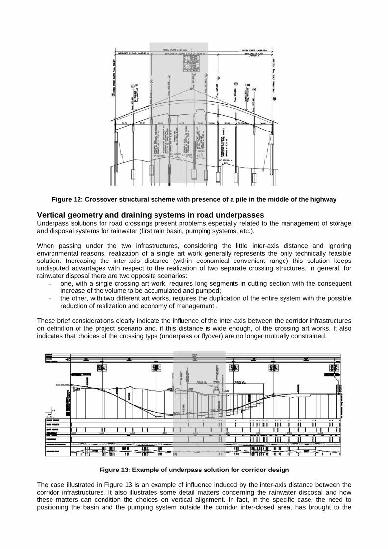
Figure 12: Crossover structural scheme with presence of a pile in the middle of the highway
Vertical geometry and draining systems in road underpasses Underpass solutions for road crossings present problems especially related to the management of storage and disposal systems for rainwater (first rain basin, pumping systems, etc.). When passing under the two infrastructures, considering the little inter-axis distance and ignoring environmental reasons, realization of a single art work generally represents the only technically feasible solution. Increasing the inter-axis distance (within economical convenient range) this solution keeps undisputed advantages with respect to the realization of two separate crossing structures. In general, for rainwater disposal there are two opposite scenarios:
- one, with a single crossing art work, requires long segments in cutting section with the consequent increase of the volume to be accumulated and pumped;
- the other, with two different art works, requires the duplication of the entire system with the possible reduction of realization and economy of management .
These brief considerations clearly indicate the influence of the inter-axis between the corridor infrastructures on definition of the project scenario and, if this distance is wide enough, of the crossing art works. It also indicates that choices of the crossing type (underpass or flyover) are no longer mutually constrained.
Figure 13: Example of underpass solution for corridor design
The case illustrated in Figure 13 is an example of influence induced by the inter-axis distance between the corridor infrastructures. It also illustrates some detail matters concerning the rainwater disposal and how these matters can condition the choices on vertical alignment. In fact, in the specific case, the need to positioning the basin and the pumping system outside the corridor inter-closed area, has brought to the

deepening of the project levels of the road compared to ground level and to the consequent increase of the ramps length and of the volume of rainwater accumulated by the road. Positioning underpass minimum level point in the inter-closed area can represent an optimal solution for the vertical alignment of the underpass itself. In this case, however, it is necessary to solve the problems concerning the basin accessibility and the final delivery of the waters, for which it could be necessary another underpass and a culvert. Accessibility of inter-closed areas If the distance between the corridor infrastructures, even if according to the operational goal of the multimodal corridor, is so big to consider each one separately, the part of territory included between the infrastructures cannot be considered an inter-closed area, instead an area to be served by appropriate connections, changing the existing road network in the light of the new configuration. In this scenario, realization of auxiliary systems (safety systems, service areas, etc.) will depend on proper requirements of the infrastructures to be realized, without any mutual effect on operating conditions. On the opposite side, the choice to lay side by side the corridor infrastructures finds its justification in the economies that can be achieved both in terms of territory occupation and private plots splitting, and in terms of impact on the remaining environmental matters. The opportunity to concentrate in delimited areas the discontinuities induced by linear infrastructures (and in the same way the possibility of joining in one single solution the works of mitigation and re-joining) can represent the most important reason of this choice. In this case, creation of inter-closed parts of territory, i.e. areas intended to the realization of service areas, is one of the focus points in the design of infrastructural corridors, up to become the most relevant matter when the economy of the territory consumption imposes location of the infrastructures side by side. The inter-axis distance clearly has a direct influence on the size of the inter-closed area and consequently on its usability for the realization of the own service areas of transportation system. In this way, optimization of the inter-closed areas size is a stand-alone specific target of the project, trough which minimizing the territory consumption and, at the same time, to obtain the availability of space for auxiliary functions. In relation to the works to be realized, it is necessary to assure accessibility for the inter-closed area, even if the plants can only be utilized by the authority. The type of connection depends on the own tasks of the service areas (e.g. the maintenance road and the emergency road must be connected to road existing network and to the motorway, in order to assure the access of the maintenance and the rescue vehicles). CONCLUSIONS The case study above discussed shows conditioning design choices owing to railway–motorway. Further, what discussed in the previous paragraph, which is representative of alternative design strategy after – effects, can be taken as reference for problems identification and as starting point to guide design choices towards the optimal solution to adopt concretely. However, the same examples show that, for a specific design problem, a complex interaction exists between design parameters involved (inter – axis distance, levels of corridor infrastructures, structural typologies, inter-closed area usage, places specifications, conflicting works conformation, etc.). On this complex interaction, instead of single design variables, depends the convenience of a given design strategy. In this way, it is sufficient to consider that, for example, about pre – existent road network crossovers cannot be possible a priori sets the optimal solutions just depending on the inter – axis distance but, tightening at only sphere of geometric parameters, it is also necessary to consider the levels of corridor infrastructures as well as pre – existent conflicting works features. Moreover, a design solution, that is optimal in regard to geometric parameters, can be unfeasible if it is valuing under criteria different from technical one (i.e. environmental or safety criteria). The intricacy between the above shown design variables matches the objective difficulty to generalize decision – making criteria for design problems solutions related to corridor infrastructures closeness. Despite of this, lessons from the case study allow to foresee possibility of generalization, even if for specific intervention field, starting by limited number of typological solutions, each of these corresponding to design parameters combination. In fact, availability of such typological solutions represents a necessary condition for evaluating – just on economic terms – quantitative effects due to design variables. It is also necessary in order to establish a decision – making criteria about optimal strategy identification.

The development of this kind of evaluation tools seems to be a crucial challenge because of the matter of two or more infrastructures closeness it will be destined to became more and more topical within the italian actuality. Actually, in Italy the position of many infrastructures is constrained because of both the strong urbanization and the hard orographical features. Furthermore it needs to be considered the opportunity offered by the strategic choice of the multimodal transport corridors in order to concentrate in delimited areas the territorial discontinuities for the benefit of the more and more environmental features instance. For these reasons it seems believable that the infrastructures closeness matter will not pertain to the main infrastructural networks (high speed railways and motorways) but also to the secondary ones (rural roads, urban bypass, traditional railway lines, etc.) All these considerations let to preventivate for the future a growing interest about the study and the analytical estimate of the effects due to the choice to lay side by side the corridor infrastructures. In this way, even at the preliminary design stage, it will be desiderable to let available more precision in terms of cost and safety of working about the transportation corridors system. In this manner, observations given in the present paper can represent the starting point to develop decision – making quantitative criteria, both in respect of designers and Public Administrations. At the same time, what discussed previously represents the basis of a modelling process that certainly is teetering within a tomorrow and almost uncharted research field. It also can represent a road engineering contribution to a wide and multidisciplinary research field. Because of this, it is actually in progress an enhancement about framework opportunity, focusing attention on re-connection of pre-existent infrastructural and natural network buildings. REFERENCES CE (1996), Decision n. 1692/1996. GU C of 23/07/1996. Bruxelles. CE (2001), Decision n. 1346/2001. GU C of 06/07/2001. Bruxelles. CE (2001), Decision n. 884/2004. GU C of 13/07/2004. Bruxelles. CIPE (2001), Delibera n. 120 del 1 dicembre 2003 - Primo Programma Delle Opere Strategiche (Legge n. 443/2001): Linea AV/AC Milano-Verona. Rome REGIONE LOMBARDIA (2004), Valutazione di Impatto Ambientale del Progetto Preliminare relativo al Collegamento Autostradale di Connessione tra le Città di Brescia e Milano. Delibera della Giunta Regionale n. VII/18656 del 5 agosto 2004. Milan REGIONE LOMBARDIA (2004), Valutazione Tecnica del Progetto Preliminare relativo al Collegamento Autostradale di Connessione tra le Città di Brescia e Milano. Delibera della Giunta Regionale n. VII/18656 del 5 agosto 2004. Milan BUZZETTI B., POLICICCHIO F., GIORDANO G., TRUGLIO G., DOMENICHINI L., LA TORRE F. (2004), Railway System-Motorway System Interference: Design Applications For AV Line Protection On The Milan-Bologna Section. Proceedings of 2P
ndP International SIIV Congress. Florence.
DOMENICHINI L., LA TORRE F., GIORDANO G. (2004), Safety Analysis of multimodal transport corridors. Proceedings of 2P
ndP International SIIV Congress. Florence
The following projects have been also considered in order to provide real examples: Linea AV/AC Milano-Venezia – Tratto Torino-Milano (Progetto Costruttivo, 2001) Linea AV/AC Milano-Venezia – Tratto Milano-Verona (Progetto Preliminare, 2003) Linea AV/AC Milano-Venezia – Tratto Milano-Verona (Progetto Definitivo, 2004) Collegamento Autostradale di Connessione tra le Città di Brescia e Milano (Progetto Preliminare, 2004)