national technical information service 5285 port royal
TRANSCRIPT
NASA/TMm2000-209891, Vol. 183
Technical Report Series on the
Boreal Ecosystem-Atmosphere Study (BOREAS)
Forrest G. Hall and David E. Knapp, Editors
Volume 183
BOREAS TE-20 NSA Soil Lab
Data
Hugo Veldhuis. University o.['Manitoba, Winnipeg
National Aeronaulic, and
Space Administration
Goddard Space Flight ('enler
Greenbelt, Ma_land 20771
October 2000

Available from:
NASA Center for AeroSpace Information7121 Standard Drive
Hanover, MD 21076-1320
Price Code: A 17
National Technical Information Service
5285 Port Royal Road
Springfield, VA 22161Price Code: AI0
BOREAS TE-20 NSA Soil Lab Data
Hugo Veldhuis
Summary
This data set contains the major soil properties of soil samples collected in 1994 at the tower flux sitesin the NSA. The soil samples were collected by Hugo Veldhuis and his staff from the University ofManitoba. The mineral soil samples were largely analyzed by Barry Goetz, under the supervision ofDr. Harold Rostad at the University of Saskatchewan. The organic soil samples were largely analyzedby Peter Haluschak, under the supervision of Hugo Veldhuis at the Centre for Land and BiologicalResources Research in Winnipeg, Manitoba.
During the course of field investigation and mapping, selected surface and subsurface soil sampleswere collected for laboratory analysis. These samples were used as benchmark references for specificsoil attributes in general soil characterization. Detailed soil sampling, description, and laboratoryanalysis were performed on selected modal soils to provide examples of common soil physical andchemical characteristics in the study area.
The soil properties that were determined include soil horizon; dry soil color; pH; bulk density;total, organic, and inorganic carbon; electric conductivity; cation exchange capacity; exchangeablesodium, potassium, calcium, magnesium, and hydrogen; water content at 0.01,0.033, and 1.5MPascals; nitrogen; phosphorus; particle size distribution; texture; pH of the mineral soil and of theorganic soil; extractable acid; and sulfur. These data are stored in ASCII text files.
Table of Contents
1) Data Set Overview2) Investigator(s)3) Theory of Measurements4) Equipment5) Data Acquisition Methods6) Observations7) Data Description8) Data Organization9) Data Manipulations10) Errors11) Notes12) Application of the Data Set13) Future Modifications and Plans14) Software15) Data Access16) Output Products and Availabilityi 7) References18) Glossary of Terms19) List of Acronyms20) Document Information
Page 1

REPORT DOCUMENTATION PAGE FormApprovedOMB No. 0704-0188
Public reporting burden for this collection of information is estimated to average 1 hour per response, including the time for reviewing instructions, searching existing data sources,
gathering and maintaining the data needed, and completing and reviewing the collection of information Send comments regarding this burden estimate or any other aspect of this
collection of information, including suggestions for reducing this burden, to Washington Headquarters Services, Directorate for Information Operations and Reports, 1215 Jefferson
Davis Highway, Suite 1204, Arlington, VA 22202-4302, and to the Office of Management and Budget, Paperwork Reduction Project (0704-0188), Washington, DC 20503.
1. AGENCY USE ONLY (Leave blank) 2. REPORT DATE 3. REPORT TYPE AND DATES COVERED
October 2000 Technical Memorandum
4. TITLE AND SUBTITLE 5. FUNDING NUMBERS
Technical Report Series on the Boreal Ecosystem-Atmosphere Study (BOREAS)
BOREAS TE-20 NSA Soil Lab Data 923
6. AUTHOR(S) RTOP: 923-462-33-01
Hugo Veldhuis
Forrest G. Hall and David E. Knapp, Editors
7. PERFORMING ORGANIZATION NAME(S) AND ADDRESS (ES) 8. PEFORMING ORGANIZATIONREPORT NUMBER
Goddard Space Flight Center
Greenbelt, Maryland 20771 2000-03136-0
9. SPONSORING / MONITORING AGENCY NAME(S) AND ADDRESS (ES) 10. SPONSORING / MONITORINGAGENCY REPORT NUMBER
National Aeronautics and Space Administration TM--2000-209891
Washington, DC 20546-0001 Vol. 183
11. SUPPLEMENTARY NOTES
H. Veldhuis: University of Manitoba, Winnipeg;
D.E. Knapp: Raytheon ITSS, NASA Goddard Space Flight Center, Greenbelt, Maryland
12a. DISTRIBUTION / AVAILABILITY STATEMENT 12b. DISTRIBUTION CODE
Unclassified-Unlimited
Subject Category: 43
Report available from the NASA Center for AeroSpace Information,
7121 Standard Drive, Hanover, MD 21076-1320. (301 ) 621-0390.
113. ABSTRACT (Maximum 200 words)
This data set contains the major soil properties of soil samples collected in 1994 at the tower flux sites in the
NSA. The soil samples were collected by Hugo Veldhuis and his staff from the University of Manitoba. Themineral soil samples were largely analyzed by Barry Goetz, under the supervision of Dr. Harold Rostad at the
University of Saskatchewan. The organic soil samples were largely analyzed by Peter Haluschak, under the
supervision of Hugo Veidhuis at the Centre lot Land and Biological Resources Research in Winnipeg,
Manitoba. During the course of field investigation and mapping, selected surface and subsurface soil sampleswere collected for laboratory analysis. These samples were used as benchmark references for specific soil
attributes in general soil characterization. Detailed soil sampling, description, and laboratory analysis wereperlbmled on selected modal soils to provide examples of common soil physical and chemical characteristics in
the study area. The soil properties that were determined include soil horizon; dry soil color; pH; bulk density;
total, organic, and inorganic carbon; electric conductivity; cation exchange capacity: exchangeable sodium,
potassium, calcium, magnesium, and hydrogen; water content at 0.01,0.033, and i.5 MPascals: nitrogen;phosphorus; particle size distribution; texture; pH of the mineral soil and of the organic soil; extractable acid;and sulfur. These data are stored in ASCII text files.
14. SUBJECT TERMS
BOREAS, terrestrial ecology, soil properties.
17. SECURITY CLASSIFICATIONOF REPORT
Unclassified
NSN 7540-01-280-5500
18. SECURITY CLASSIFICATIONOF THIS PAGE
Unclassified
19. SECURITY CLASSIFICATIONOF ABSTRACT
Unclassified
15. NUMBER OF PAGES
2716. PRICE CODE
!20. LIMITATION OF ABSTRACT
UL
Standard Form 298 (Rev. 2-89)Prescnbed by ANSI Std Z3918298-102


1. Data Set Overview
1.1 Data Set IdentificationBOREAS TE-20 NSA Soil Lab Data
1.2 Data Set Introduction
This data set was collected by Hugo Veldhuis, who worked under contract with the BOReal
Ecosystem-Atmosphere Study (BOREAS) Terrestrial Ecology (TE)-20 team to collect soil samples atthe BOREAS Northern Study Area (NSA) tower sites and to provide the results of various laboratorytests performed on the soil samples.
1.3 Objective/PurposeThere was a general need within BOREAS for soil properties to be obtained. These data were not
collected with any particular application in mind. Various groups in BOREAS needed measurements ofsoil carbon content, bulk density, electrical conductivity (EC), and other soil properties for use inecological models.
1.4 Summary of Parameters
The following soil parameters were measured: bulk density, pH of the soil, total carbon (TC),organic carbon (OC), inorganic carbon (IC), buffered cation exchange capacity (CEC), exchangeablesodium (Na), exchangeable potassium (K), exchangeable calcium (Ca), exchangeable magnesium(Mg), field moisture, saturated moisture, wilting moisture, total nitrogen (N), particle size distribution,extractable acidity, and total sulfur (S).
1.5 Discussion
During the field investigation and mapping, selected surface and subsurface soil samples werecollected for laboratory analysis. These samples were used as benchmark references for specific soilattributes in general soil characterization. Detailed soil sampling, description and laboratory analysiswere performed on selected modal soils to provide examples of common soil physical and chemicalcharacteristics in the study area.
1.6 Related Data Sets
Agriculture Canada Central Saskatchewan Vector Soils DataCanSIS Regional Soils Data in Vector Format
BOREAS Regional Soils Data in Raster Format and AEAC ProjectionBOREAS Soils Data over the SSA in Raster Format and AEAC ProjectionBOREAS TE-01 Soils Data over the SSA Tower Sites in Raster FormatBOREAS TE-01 SSA Soil Lab DataBOREAS TE-20 Soils Data over the NSA and Tower Sites in Vector FormatBOREAS TE-20 Soils Data over the NSA and Tower Sites in Raster FormatBOREAS TGB- 12 Soil Carbon and Flux Data of NSA-MSA in Raster FormatBOREAS TGB- 12 Soil Carbon Data over the NSA
2. Investigator(s)
2.1 Investigator(s) Name and TitleHugo Veldhuis, Senior PedologistAgriculture & Agri-Food Canada
2.2 Title of Investigation
Soils of Tower Sites and Super Site, Northern Study Area, Thompson, Manitoba, Canada
Page 2
2.3 Contact Information
Contact 1:
Hugo VeldhuisCentre for Land & Biological Resources ResearchManitoba Land Resource Unit
Rm. 362A, ELLIS Bldg.Univ. of Manitoba
Winnipeg, MB CANADA R3T 2N2(204) 474-6124(204) 474-7633 (fax)
Contact 2:
David KnappRaytheon ITSSNASA GSFCCode 923Greenbelt, MD 20771(301) 286-1424(301) 286-0239 (fax)David.Knapp@ gsfc.nasa.gov
3. Theory of Measurements
A number of different soil properties were measured for use by BOREAS investigators. The theoryand methods used to measure these properties are as follows:
• Bulk Density: An intact known volume of soil is removed, dried, and weighed; the densitycan then be calculated.
• TC: All types of carbon will be combusted into carbon dioxide (CO2) in a flow of oxygen(02) at 2,500 °F.
• IC: IC reacts with acid producing CO2, which is quantified through titration.• OC: Equals measured TC minus measured IC.• EC: The soil's ability to carry an electrical current which is indicative of salt content.• CEC: If a soil is washed with one cation (Ba), and the other cations are leached, the first
cation fills the exchange sites of the leached cation, and equals the soil's CEC.• Exchangeable Cations: Equals the quantity of cations in the leachate after they have been
exchanged off the soil.• Soil Moisture Retentions: Equals the amount of water in soils under a suction equal to 1/10,
1/3, and 15 atmospheres (i.e., field moisture 10th, saturated moisture, and wilting moisture,as described respectively in the original soil analysis report).
• Soil Size Fractions: Clay and silt are measured based on the principle that the speed at which aparticle will fall in water will depend on the size of the particle.
4. Equipment
4.1 Sensor/Instrument Description• Bulk density: 10 cm diameter tube, 10 cm long.• TC: LECO CR12 Carbon Determinator 781-600
• CEC and exchangeable cations: Cation concentrations were measured by atomicadsorption-Perkin Elmer 3100.
Page 3
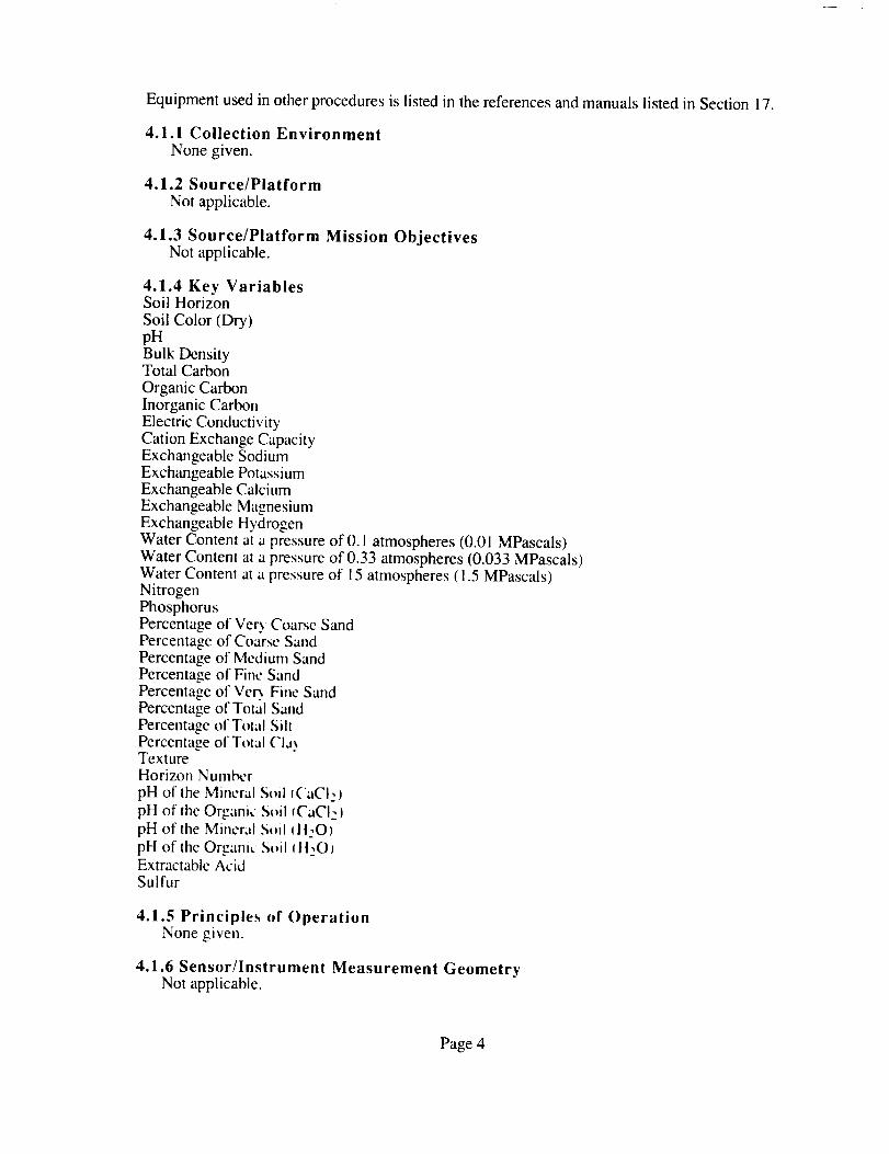
Equipmentusedinotherproceduresis listedin thereferencesandmanualslistedin Section17.
4.1.1 Collection Environment
None given.
4.1.2 Source/Platform
Not applicable.
4.1.3 Source/Platform Mission ObjectivesNot applicable.
PercentagePercentagePercentagePercentagePercentagePercentagePercentageTexture
4.1.4 Key VariablesSoil Horizon
Soil Color (Dry)pHBulk DensityTotal Carbon
Organic CarbonInorganic CarbonElectric ConductivityCation Exchange CapacityExchangeable SodiumExchangeable PotassiumExchangeable CalciumExchangeable MagnesiumExchangeable HydrogenWater Content at a pressure of 0.1 atmospheres (0.01 MPascals)Water Content at a pressure of 0.33 atmospheres (0.033 MPascals)Water Content at a pressure of 15 atmospheres (1.5 MPascalsNitrogenPhosphorusPercentage of Very Coarse Sand
of Coarsc Sandof Mcdium Sandof Fine Sandof Ver_ Fine Sandof Total Sandof T_tal Siltof Total ('la_
Horizon Number
pH of the Mineral S_il f('aCI2 )pH of the Organic Soil _CaCIz)
pH of the Mineral St_i141t:O)pH of the Organic S_tl _ttzO_Extractablc AcidSulfur
4.1.5 Principles cJf OperationNone given.
4.1.6 Sensor/Instrument Measurement Geometry
Not applicable.
Page 4

4.1.7 Manufacturer of Sensor/Instrument
None given.
4.2 CalibrationCalibration information was provided for the following instruments:• Total Carbon: LECO 501-034 12%
Dry soil colors were measured according to the Munsell color chart. All other standards were preparedin the laboratory from pure analytical compounds and tested against National Institute of Standards andTechnology (NIST) standards.
4.2.1 SpecificationsNone given.
4.2.1.1 Tolerance
None given.
4.2.2 Frequency of CalibrationNone given.
4.2.3 Other Calibration InformationNone.
5. Data Acquisition Methods
Bulk Density: Cylinders of known volume and weight are pressed into the soil and filled with soilin its natural state. The soil and cylinder are dried at 105 °C and weighed. The soil weight is thencalculated and divided by the cylinder volume (Manual on Soil Sampling and Methods of Analysis).
TC: Measured by combustion of dried soil samples in a LECO CR12 Carbon Determinator (LECOCorporation Application Bulletin form no. 203-601-071).
IC: Measured through digestion in acid, and evolved CO2 is measured directly as carbonic acid in a
two-endpoint titration (Tiessen et al., 1983).OC: Equals measured TC minus measured IC.Total Nitrogen and Phosphorus: Digestion in H2SO4 and H202 (Thomas et al., 1967). Products
NH4+and P were measured colorimetrically by the ammonia-salicylate method (Technicon, 1973) and
acid-molybdate blue method (Murphy and Riley, 1962), respectively.Electrical conductivity and pH: Standard laboratory meter.CEC: The cations on the exchange are replaced with barium (Ba), which is then exchanged off the
soil with NH4 and the amount of Ba is measured (p. 54, Manual on Soil Sampling and Methods of
Analysis).Exchangeable Cations: Measured in leachate after Ba has exchanged them off the soil; Na+, K+,
Ca2 +, Mg2 + by atomic absorption and H+ by back titration with HC1 to pH 5.1 (p. 83, Manual on Soil
Sampling and Methods of Analysis).Soil Moisture Retentions: Pressure plate extraction (p. 45, Manual on Soil Sampling and Methods
of Analysis).Soil Size Fractions: Pipette method (p. 6, Manual on Soil Sampling and Methods of Analysis).
Page 5

6. Observations
6.1 Data Notes
The table below lists soil classification (by order, sub-group, and soil type), site location, soil polygon(Polynum), and BOREAS site location of soil pits in this study. This information enables the user tospatially link soils data from this study to the TE-20 Soils Data over the NSA-MSA and Tower Sites inRaster Format and TGB-12 Soil Carbon and Flux Data of NSA-MSA in Raster Format data sets. See
TE-20 soils data documentation, TE-20 Soils Report, and Soil Classification Working Group (1998)for detailed description of soil classification.
Soil
Soil Pit Order Subgroup Type Site Polynum BOREAS Site Location
..........................................
FEN02 ORGANIC TYF FEN FEN 21 NSA-FEN-FLXTR 9-TE20-SOLO2
FEN04 CRYSOLIC MEOC PAA FEN 16 NSA-FEN-FLXTR 9-TE20-SOLO4
FEN06 CRYSOLIC MEOC PAA FEN 16 NSA-FEN-FLXTR 9-TE20-SOLO6
FEN07 ORGANIC TYF BGC FEN i0 NSA-FEN-FLXTR 9-TE20-SOLO7
FEN08 CRYOSOLIC TMEOC PLH FEN 12 NSA-FEN-FLXTR 9-TE20-SOLO8
FEN09 ORGANIC TYF FCD FEN 8 NSA-FEN-FLXTR 9-TE20-SOLO9
OBS01 LUVISOLIC OGL WBW OBS 31 NSA-OBS-FLXTR 9-TE20-SOLOI
OBS02 LUVISOLIC OGL SWK OBS 19 NSA-OBS-FLXTR 9-TE20-SOLO2
OBS03 CRYOSOLIC RSC PLH OBS 12 NSA-OBS-FLXTR 9-TE20-SOLO3
OBS04 CRYSOLIC TFIOC NIC OBS 16 NSA-OBS-FLXTR 9-TE20-SOLO4
OBS05 CRYSOLIC TFIOC NIC OBS 21 NSA-OBS-FLXTR 9-TE20-SOLO5
OBS06 GLEYSOLIC OLG LPR OBS 15 NSA-OBS-FLXTR 9-TE20-SOLO6
OBS07 LUVISOLIC OGL WBW OBS 19 NSA-OBS-FLXTR 9-TE20-SOLO7
OJP01 BRUNISOLIC EDYB PCP OJP 9 NSA-OJP-FLXTR 9-TE20-SOLOI
OJP02 BRUNISOLIC EDYB PCP OJP 13 NSA-OJP-FLXTR 9-TE20-SOLO2
OJP03 BRUNISOLIC EDYB PCP OJP 9 NSA-OJP-FLXTR 9-TE20-SOLO3
OJP04 BRUNISOLIC EDYB PCP OJP 9 NSA-OJP-FLXTR 9-TE20-SOLO4
OJP05 BRUNISOLIC EDYB PCP OJP 2 NSA-OJP-FLXTR 9-TE20-SOLO5
OJP06 BRUNISOLIC EDYB PCP OJP 3 NSA-OJP-FLXTR 9-TE20-SOLO6
OJP07 GLEYSOLIC OG WTP OJP 12 NSA-OJP-FLXTR 9-TE20-SOLO7
OTA01 LUVISOLIC OGL WBW OTA 5 NSA-90A-9TETR 9-TE20-SOLOI
OTA02 LUVISOLIC OGL PPU OTA 13 NSA-90A-9TETR 9-TE20-SOLO2
US01 LUVISOLIC OGL SWK SST 41 NSA-9BS-9TETR 9-TE20-SOLOI
YJP01 GLEYSOLIC OG PCH YJP 12 NSA-YJP-FLXTR 9-TE20-SOLOI
YJP02 BRUNISOLIC EDYB PCP YJP 1 NSA-YJP-FLXTR 9-TE20-SOLO2
YJP03 BRUNISOLIC EDYB PCP YJP 14 NSA-YJP-FLXTR 9-TE20-SOLO3
YJP04 BRUNISOLIC GLEDYB PCB YJP 9 NSA-YJP-FLXTR 9-TE20-SOLO4
YJP05 BRUNISOLIC GLEDYB LWP YJP 9 NSA-YJP-FLXTR 9-TE20-SOLO5
YJP06 BRUNISOLIC EDYB CLK YJP 17 NSA-YJP-FLXTR 9-TE20-SOLO6
SOILDEV = Soil development (soil classification).
Order
Brunisoiic
EDYB
GLEDYB
EEB
GLEEB
Subgroup
Eluviated Dystric Brunisol
Gleyed Eluviated Dystric Brunisol
Eluviated Eutric Brunisol
Gleyed Eluviated Eutric Brunisol
Page 6

Gleysolic
OHG
RHG
OG
FEG
OLG
HULG
Luvisolic
OGL
DGL
GLGL
GLDGL
Organic
TYF
MEF
TF
TMEF
HYF
TYM
FIM
TM
TFIM
THUM
TH
TFIH
TMEH
Cryosolic
OSC
RSC
OTC
RTC
FIOC
MEOC
HUOC
TFIOC
TMEOC
THUOC
VARIANT
Code
C
i
P
Orthic Humic Gleysol
Rego Humic Gleysol
Orthic Gleysol
Ferric Gleysol
Orthic Luvic Gleysol
Humic Luvic Gleysol
Orthic Gray Luvisoi
Dark Gray Luvisol
Gleyed Gray Luvisol
Gleyed Dark Gray Luvisol
Typic Fibrisol
Mesic Fibrisol
Terric Fibrisol
Terric Mesic Fibrisol
Hydric Fibrisol
Typic Mesisol
Fibric Mesisol
Terric Mesisol
Terric Fibric Mesisel
Terric Mesic Humisol
Terric Humisol
Terric Fibric Humisol
Terric Mesic Humisol
Orthic Static Cryosol
Regosolic Static Cryosol
Orthic Turbic Cryosol
Regosolic Turbic Cryosol
Fibric Organic Cryosol
Mesic Organic Cryosol
Humic Organic Cryosoi
Terric Fibric Organic Cryosol
Terric Mesic Organic Cryosol
Terric Humic Organic Cryosol
Class
Cryic
Lithic
Peaty
Page 7

SOIL TYPE (See TE-20 Soils Report for descriptions of soil types.)
ATK - Atik
BDY - Baldy
BGC - Bog Collapse
BRN - Brannigan Creek
BTT - Button
CLK - Clarke
CMK - Cormorant Lake
FCD - Fen Collapse
FEN - Fen
GES - Grass River
LFR - La Perouse
LWP - Low Pine
MDR - Medard
NIC - Nichols Lake
PAA - Palsa
PCB - Partridge Beak
PCH - Partridge Head
PCP Partridge Crop
PKW - Pakwa
PLH Palsa Hummock
PLT - Plateau
PPU - Pipun
ROK - Roe Lake
SWK - Sipiwesk
SYB Sandy Bog
TBL - Turnbull
TFN - Thaw Fen
TYL - Tyrrell
WBW - Wabowden
WRL - Warren Landing
WTP - Wet Pine
YGP - Young Pine
SOIL PHASE
Code
d Deep
h Humus
s Shallow
v Very deep
w Very shallow
x Complex
Note: The Trace Gas Biogeochemistry (TGB)-12 and TE-20 raster data sets cover the same area of theNSA-Modeling Sub-Area (MSA). Both data sets contain a raster image and an attribute file thatdescribes each soil polygon. The TGB-12 raster data were modified to account for the 1981 burn. Inthis data set, polygons with POLYNUM 238 - 248 are within the burn.
6.2 Field Notes
None given.
Page 8

7.1 Spatial Characteristics
7. Data Description
7.1.1 Spatial CoverageThe tower flux sites are located in the NSA at the following North American Datum of 1983
(NAD83) coordinates:
Longitude Latitude
Old Black Spruce (OBS) 98.48139 °W 55.88007 °N
Old Jack Pine (OJP) 98.623958°W 55.9284153ON
Fen 98.420716oW 55.9148083ON
Young Jack Pine (YJP) 98.287056°W 55.8957528ON
Aspen (aux. site T2Q6A) 98.674786°W 55.8869081ON
7.1.2 Spatial Coverage MapNone.
7.1.3 Spatial ResolutionThese data represent point locations.
7.1.4 ProjectionNot applicable.
7.1.5 Grid DescriptionNot applicable.
7.2 Temporal Characteristics
7.2.1 Temporal CoverageAll measured parameters will change only over the long term, so any data could be valuable to
generalize the soil characteristics of the area for many years in the future.
7.2.2 Temporal Coverage MapThe measurement of these soil properties was based on soil samples that were collected in 1994.
7.2.3 Temporal Resolution
The soil samples were collected at a certain point in time. However, the soil properties that werederived from the samples do not tend to change significantly with time.
7.3 Data Characteristics
Page 9

7.3.1 Parameter/Variable
The parameters contained in the data files on the CD-ROM are:
Column Name
..............................
SITE NAME
SUB SITE
MEASUREMENT YEAR
PIT
HORIZON
START DEPTH
END DEPTH
BULK DENSITY
TOTAL SOIL C CONTENT
SOIL ORG C CONTENT
SOIL INORG C CONTENT
CATION EX CAPACITY
EXCHANGE SODIUM
EXCHANGE POTASSIUM
EXCHANGE CALCIUM
EXCHANGE MAGNESIUM
WATER CONTENT 10KPA
WATER CONTENT 33KPA
WATER CONTENT 1500KPA
SOIL NITROGEN CONTENT
SOIL PHOSPHORUS CONTENT
VERY COARSE SAND
COARSE SAND
MEDIUM SAND
FINE SAND
VERY FINE SAND
TOTAL SAND
TOTAL SILT
TOTAL CLAY
SOIL TEXTURE
HORIZON NUM
MINRL SOIL AND CACL2 PH
ORG SOIL AND CACL2 PH
MINRL SOIL AND H20 PH
ORG SOIL AND H20 PH
SOIL EXTRACT ACIDITY
SOiL SULFUR CONTENT
CRTFCN CODE
REVISION DATE
Page 10
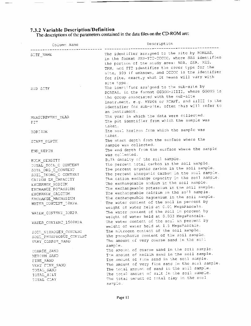
7.3.2 Variable Description/DefinitionThe descriptions of the parameters contained in the data files on the CD-ROM are:
SITE NAME
SUB SITE
MEASUREMENT YEAR
PIT
HORIZON
START DEPTH
END DEPTH
BULK DENSITY
TOTAL SOIL C CONTENT
SOIL ORG C CONTENT
SOIL INORG C CONTENT
CATION EX CAPACITY
EXCHANGE SODIUM
EXCHANGE POTASSIUM
EXCHANGE CALCIUM
EXCHANGE MAGNESIUM
WATER CONTENT 10KPA
WATER CONTENT 33KPA
WATER CONTENT 1500KPA
SOIL NITROGEN CONTENT
SOIL PHOSPHORUS CONTENT
VERY COARSE SAND
COARSE SAND
MEDIUM SAND
FINE SAND
VERY FINE SAND
TOTAL SAND
TOTAL SILT
TOTAL CLAY
Column Name Description
..............................................
The identifier assigned to the site by BOREAS,
in the format SSS-TTT-CCCCC, where SSS identifies
the portion of the study area: NSA, SSA, REG,
TRN, and TTT identifies the cover type for the
site, 999 if unknown, and CCCCC is the identifier
for site, exactly what it means will vary with
site type.
The identifier assigned to the sub-site by
BOREAS, in the format GGGGG-IIIII, where GGGGG is
the group associated with the sub-site
instrument, e.g. HYD06 or STAFF, and IIIII is the
identifier for sub-site, often this will refer to
an instrument.
The year in which the data were collected.
The pit identifier from which the sample was
taken.
The soil horizon from which the sample was
taken.
The start depth from the surface where the
sample was collected.
The end depth from the surface where the sample
was collected.
Bulk density of the soil sample.
The percent total carbon in the soil sample.
The percent organic carbon in the soil sample.
The percent inorganic carbon in the soil sample.
The cation exchange capacity in the soil sample.
The exchangeable sodium in the soil sample.
The exchangeable potassium in the soil sample.
The exchangeable calcium in the soil sample.
The exchangeable magnesium in the soil sample.
The water content of the soil in percent by
weight of water held at 0.01MegaPascals.
The water content of the soil in percent by
weight of water held at 0.033 MegaPascals.
The water content of the soil in percent by
weight of water held at 1.5 MegaPascals.
The nitrogen content of the soil sample.
The phosphorus content of the soil sample.
The amount of very coarse sand in the soil
sample.
The amount of coarse sand in the soil sample.
The amount of medium sand in the soil sample.
The amount of fine sand in the soil sample.
The amount of very fine sand in the soil sample.
The total amount of sand in the soil sample.
The total amount of silt in the soil sample.
The total amount of total clay in the soil
sample.
Page 11
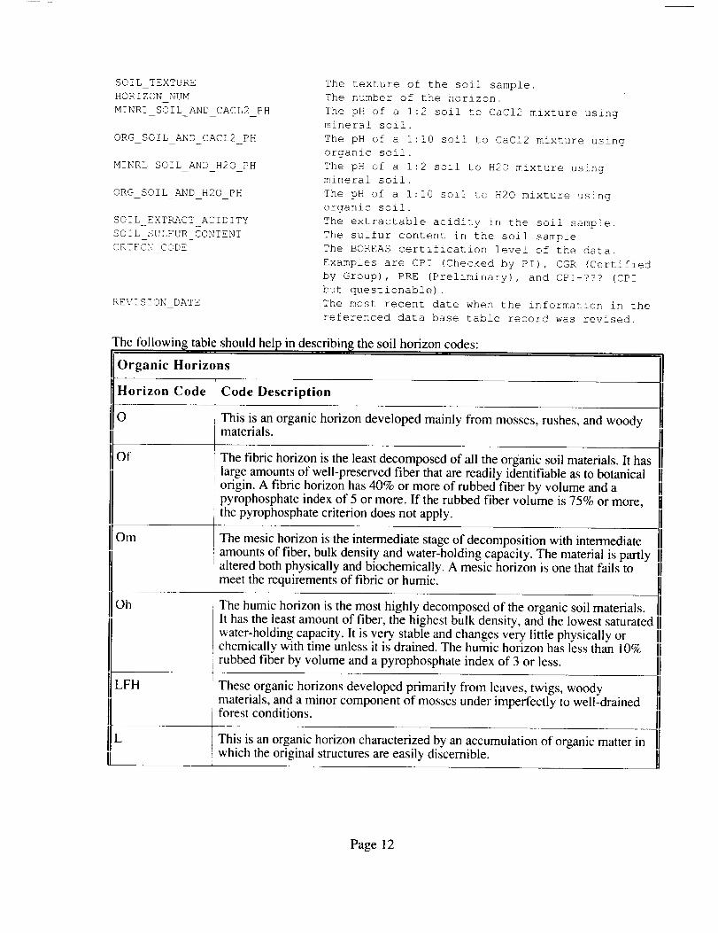
SOIL_TEXTURE The texture of the soil sample.
HORIZON NUM The number of the horizon.
MINRL SOIL AND CACL2_PH The pH of a 1:2 soil to CaCI2 mixture using
mineral soil.
ORG_SOIL AND CACL2 PH The pH of a I:i0 soil to CaCI2 mixture using
organic soil.
MINRL_SOIL_AND H20_PH The pH of a 1:2 soil to H20 mixture using
mineral soil.
ORG SOIL_AND_H20 PH The pH of a I:I0 soil to H20 mixture using
organic soil.
SOILEXTRACTACIDITY The extractable acidity in the soil sample.
SOILSULFURCONTENT The sulfur content in the soil sample.
CRTFCN_CODE The BOREAS certification level of the data.
Examples are CPI (Checked by PI), CGR (Certified
by Group), PRE (Preliminary), and CPI-??? (CPI
but questionable).
REVISION_DATE The most recent date when the information in the
referenced data base table record was revised.
The tbllowing table should help in describing the soil horizon codes:
[lorganic Horizons
]1_ Code Code Description
[0 This is an organic horizon developed mainly from mosses, rushes, and woody
materials. IIThe fibric horizon is the least decomposed of all the organic soil materials. It has
Oh
IlL
large amounts of well-preserved fiber that are readily identifiable as to botanicalorigin. A fibric horizon has 40% or more of rubbed fiber by volume and apyrophosphate index of 5 or more. If the rubbed fiber volume is 75% or more,the pyrophosphate criterion does not apply.
The mesic horizon is the intermediate stage of decomposition with intermediate
amounts of fiber, bulk density and water-holding capacity. The material is partly l[altered both physically and biochemically. A mesic horizon is one that fails to I]
meet the requirements of fibric or humic. ]1
The humic horizon is the most highly decomposed of the organic soil materials. I]
It has the least amount of fiber, the highest bulk density, and the lowest saturated ]]water-holding capacity. It is very stable and changes very little physically or 1]chemically with time unless it is drained. The humic horizon has less than 10% l]
rubbed fiber by volume and a pyrophosphate index of 3 or less. 1]
iiThese organic horizons developed primarily from leaves, twigs, woodymaterials, and a minor component of mosses under imperfectly to well-drainedforest conditions.
This is an organic horizon characterized by an accumulation of organic matter inwhich the original structures are easily discernible.
Page 12

F
H
Thisis an organic horizon characterized by an accumulation of partlydecomposed organic matter. The original structures in part are difficult torecognize. The horizon may be partly comminuted by soil fauna as in moder, orit may be a partly decomposed mat permeated by fungal hyphae as in mor.
This is an organic horizon characterized by an accumulation of decomposedorganic matter in which the original structures are indiscernible. This material 11differs from the F horizon by its greater humification chiefly through the action IIof organisms. It is frequently intermixed with mineral grains, especially near the [1
junction with the mineral horizon. [[
Mineral Horizons ]IMineral horizons are those that contain less than 30% organic matter by weight as specified for
[1organic horizon.
]1Horizon Code
B
C
R
Code Description
This is a mineral horizon or horizons formed at or near the surface in the zone of [[
leaching or removal of materials in solution and suspension or of maximum in IIsitu accumulation of organic matter, or both. Included are: ]1
• horizons in which organic matter has accumulated as a result of [[biological activity (Ah); 1]
• horizons that have been eluviated of clay, iron, aluminum, or organic IImatter, or all of them (Ae); II
• horizons having characteristics of 1) and 2) above but transitional to IIunderlying B or C (AB or A and B); II
• horizons markedly disturbed by cultivation or pasture (Ap). I]
IIThis is a mineral horizon or horizons characterized by one or more of thefollowing:
• an enrichment in silicate clay, iron, aluminum, or humus, alone or incombination (Bt, Bf, Bfh, Bhf, and Bh);
• a prismatic or columnar structure that exhibits pronounced coatings orstainings and significant amount of exchangeable Na (Bn);
• an alteration by hydrolysis, reduction, or oxidation to give a change incolor or structure from horizons above or below, or both, and does notmeet the requirements of 1) and 2) above (Bm, Bg).
This is a mineral horizon or horizons comparatively unaffected by the pedogenicprocesses operative in A and B, excepting (i) the process of gleying, and (ii) the l]accumulation of calcium and magnesium carbonates and more soluble salts (Cca, IICsa, Cg, and C). Marl and diatomaceous earth are considered to be C horizons. [1
IIThis is consolidated bedrock that is too hard to break with the hands or to dig IIwith a spade when moist and that does not meet the requirement of a C horizon. I1The boundary between the R layer and overlying unconsolidated material is IIcalled a lithic contact. II
II
Page 13

[[w This is a layer of water in Gleysolic, Organic, or Cryosolic soils. It is called ahydric layer in Organic soils.
Lower-Case Suffixes
Horizon Code Code Description
b Buried soil horizon.
A cemented (irreversible) pedogenic horizon. The ortstein of a Podzol, and alayer cemented by calcium carbonate and a duripan are examples.
C
A horizon with secondary carbonate enrichment where the concentration of lime
e
exceeds that present in the unenriched parent material. It is more than 10 cm 11thick, and if it has a CaCO3 equivalent of less than 15 percent it should have at IIleast 5 percent more CaCO3 equivalent than the parent material (IC). If it has IImore than 15 percent CaCO3 equivalent it should have 1/3 more CaCO3 1[equivalent than the IC. If no IC is present, this horizon is more than 10 cm thickand contains more than 5 percent by volume of secondary carbonates inconcretions or soft, powdery forms.
cc Cemented (irreversible) pedogenic concretions.
A horizon characterized by the eluviation of clay, iron, aluminum, or organicmatter alone or in combination. When dry, it is usually higher in color value by II
or more units than an underlying B horizon. It is used with A (Ae). IIA horizon enriched with amorphous material, principally AI and Fe combined 11
with organic matter. It usually has a hue of 7.5YR or redder or its hue is 10YR 1]near the upper boundary and becomes yellower with depth. When moist, the 11chroma is higher than 3 or the value is 3 or less. It contains 0.6% or more IIpyrophosphate-extractable AI+Fe in textures finer than sand and 0.4% or more in [1sands (coarse sand, sand, fine sand, and very fine sand). The ratio of IIpyrophosphate-extractable AI+Fe to clay (less than 0.002 mm) is more than 0.05 IIand OC exceeds 0.5%. Pyrophosphate-extractable Fe is at least 0.3%, or the IIratio of OC to pyrophosphate-extractable Fe is less than 20, or both are true. It is IIused with B alone (Bf), with B and h (Bhf), with B and g (Bfg), and with other IIsuffixes. The criteria for "f" do not apply to Bgf horizons. II
The following horizons are differentiated on the basis of OC content: Bf- 0.5% to 5% OC. Bhf-
1]more than 5% OC.
[Horizon Code Code Description
Page 14

Aeg
Bg
ii
A horizon characterized by gray colors, or prominent mottling, or both, [Iindicative of permanent or periodic intense reduction. Chromas of the matrix are IIgenerally 1 or less. It is used with A and e (Aeg); with B alone (Bg); with B and ][f (Bfg); with B, h, and f (Bhfg); with B and t (Btg); with C alone (Cg); with C IIand k (Ckg); and several others. In some reddish parent materials, matrix colors [[of reddish hues and high chromas may persist, despite long periods of reduction. IIIn these soils, horizons are designated as g if there is gray mottling or if there is II
marked bleaching on ped faces or along cracks. II
This horizon must meet the definitions of A, e, and g.
IIThese horizons are analogous to Bm horizons but they have colors indicative of 11poor drainage and periodic reduction. They include horizons occurring between IIA and C horizons in which the main features are: (i) colors of low chroma, that IIis: chromas of 1 or less, without mottles on ped surfaces or in the matrix if peds IIare lacking; or chromas of 2 or less in hues of 10YR or redder, on ped surfaces IIor in the matrix if peds are lacking, accompanied by more prominent mottles than 1]those in the C horizon; or hues bluer than 10Y, with or without mottles on ped IIsurfaces or in the matrix if peds are lacking. (ii) colors indicated in (i) and a 1]change in structure from that of the C horizons. (iii) color indicated in (i) and IIilluviation of clay too slight to meet the requirements of Bt; or accumulation or II
i •
yon oxide too slight to meet the limits of Bgf. (iv) colors indicated in (i) and IIremoval of carbonates. Bg horizons occur in some Orthic Humic Gleysols and II
, some Orthic Gleysols. ]1
Bfg, Bhfg, Btg. When used in any of these combinations the limits set for f, hf, t, and othersand others, must be met.
Bgf
Cg, Ckg. Ccag.
[[_C_sg, Csag
[Iah
[Ahe
II
IIThe dithionite-extractable Fe of this horizon exceeds that of the IC by 1% or IImore. Pyrophosphate-extractable A1 ÷ Fe is less than the minimum limit specified IIfor 'f' horizons. This horizon occurs in Fera Gleysols and Fera Humic Gleysols, IIand possibly below the Bfg of gleyed Podzols. It is distinguished from the Bfg IIof glcyed Podzols on the basis of the extractability of the Fe and AI. The Fe in IIthc Bgf horizon is thought to have accumulated as a result of the oxidation of IIferrous iron. The iron oxide formed is not associated intimately with organic IImattcr or with AI, and it is sometimes crystalline. The Bgf horizons are usually IIprominently mottled, with more than half of the soil material occurring as mottles IIof high chroma. 11
IIWhen g is used with C alone, or with C and one of the lowercase suffixes k, ca,
,. or _a. il must meet the definition for C and for the particular suffix, ii
A horizon enriched with organic matter. It is used with A alone (Ah); or with A [[
and c _Ahc): or with B alone (Bh); or with B and f (Bhf). II•\ horizon enriched with organic matter that either has a color value at least one []
umt Io_er than the underlying horizon or contains 0.5% more OC than the IC, or IIboth. It contains less than 17% OC by weight. II
U
An Ah horizon that has undergone eluviation as evidenced, under natural IIconditions, by streaks and splotches of differing shades of gray and often by ]1platy structure. It may be overlain by a darker-colored Ah and underlain by a [[lighter colored Ae. 1]
II
Page 15

Bh
Bhf
Aej
13tj
m
n
s
II
This horizon contains more than 1% organic carbon, less than 0.3% ]]pyrophosphate-extractable Fe, and has a ratio of OC to pyrophosphate- IIextractable of 20 or more. Generally the color value and chroma are less than 3 IIwhen moist. II
Oefine under IIUsed as a modifier of the suffixes e, f, g, n, and t to denote an expression of, but][failure to meet, the specified limits of the suffix it modifies. It must be placed to IIthe right of and adjacent to the suffix it modifies. For example, Bfgj means a Bf IIhorizon with weak expression of gleying; Bfjgj means a B horizon with weak II
expression of both 'f' and 'g' features. IIAn eluvial horizon that is thin, discontinuous, or slightly discernible.
A horizon with some illuviation of clay, but not enough to meet the limits of Bt. 11
Btgj, Bmgj Horizons that are mottled but do not meet the criteria of Bg. IIA horizon with some accumulation of pyrophosphate-extractable A! and Fe but 1]not enough to meet the limits of Bf. Bntj or Bnj Horizons in which development IIof solonetzic B properties is evident but insufficient to meet the limits for Bn or II
Denotes the presence of carbonate, as indicated by visible effervescence whendilute HC1 is added. Most often it is used with B and m (Bmk) or C (Ck), andoccasionally with Ah or Ap (Ahk, Apk), or organic horizons (Ofk, Omk).
A horizon slightly altered by hydrolysis, oxidation, or solution, or all three, togive a change in color or structure, or both. It has: II
• Evidence of alteration in one of the following forms: II• Higher chromas and redder hues than the underlying II• Removal of carbonates, either partially (Bmk) or completely II
(Bm). II• Illuviation, if evident, too slight to meet the requirements of a Bt or a II
podzolic B. II• Some weatherable minerals. II
No cementation or induration and lacks a brittle consistence when moist. [IThis suffix can be used as Bm, Bmgj, Bmk, and Bms. II
IIA horizon in which the ratio of exchangeable Ca to exchangeable Na is 10 or ]1
less. It must also have the following distinctive morphological characteristics: nprismatic or columnar structure, dark coatings on ped surfaces, and hard to very IIhard consistence when dry. It is used with B, as Bn or Bnt. II
IiA horizon disturbed by man's activities, such as cultivation, logging, habitation,etc. It is used with A and O.
A horizon with salts, including gypsum, which may be detected as crystals orveins, as surface crusts of salt crystals, by depressed crop growth, or by the 11presence of salt-tolerant plants. It is commonly used with C and k (Csk), but can IIbe used with any horizon or combination of horizon and lowercase suffix. II
Page 16

lisa A horizon with secondary enrichment of salts more soluble than calcium and JJ
t
B and g (Btg), with B and n (Bnt), etc.
Bt
magnesium carbonates, in which the concentration of salts exceeds that present in ]Jthe unenriched parent material. The horizon is 10 cm or more thick. The IIconductivity of the saturation extract must be at least 4 ms/cm and must exceed II
that of the C horizon by at least one-third. 1!/IAn illuvial horizon enriched with silicate clay. It is used with B alone (Bt), with
A Bt horizon is one that contains illuvial layer lattice clays. It forms below aneluvial horizon, but may occur at the surface of a soil that has been partially JJtruncated. It usually has a higher ratio of fine clay to total clay than IC. It has the IIfollowing properties: II
• If any part of an eluvial horizon remains and there is no lithologic JJdiscontinuity between it and the Bt horizon, the Bt horizon contains ]]more total and fine clay than the eluvial horizons, as follows: II• If any part of the eluvial horizon has less than 15% total clay in II
the fine earth fraction (2 mm), the Bt horizon must contain at least II3% more clay, e.g., Ae 10% clay, Bt minimum 13% clay. II
• If the eluvial horizon has more than 15% and less than 40% total IIclay in the fine earth fraction, the ratio of the clay in the Bt IIhorizon to that in the eluviai horizon must be 1.2 or more, e.g., II20% clay increase in the Bt over Ae. II
• If the eluvial horizon has more than 40% total clay in the fine IIearth fraction, the Bt horizon must contain at least 8% more clay IIthan the eluvial horizon, e.g., Ae 50% clay, Bt at least 58% clay. II
• A Bt horizon must be at least 5 cm thick. In some sandy soils where clay IIaccumulation occurs in the lamellae, the total thickness of the lamellae JJshould be more than 10 cm in the upper 150 cm of the profile. II
• In massive soils the Bt horizon should have oriented clays in some pores JJand also as bridges between the sand grains. II
• If peds are present, a Bt horizon shows clay skins on some of the JJvertical and horizontal ped surfaces and in the fine pores, or shows 11oriented clays in 1% or more of the cross section, as viewed in thin ]Jsection. II
• If a soil shows a lithoiogic discontinuity between the eluvial horizon and IIthe Bt horizon, or if only a plow layer overlies the Bt horizon, the Bthorizon need show only clay skins in some part, either in some finepores or on some vertical and horizontal ped surfaces. Thin sectionsshould show that some part of the horizon has about 1% or more oforiented clay bodies.
Btj Btj and Btg are defined under j and g.
UII
A horizon that is markedly disrupted by physical or faunal processes other than IIcryoturbation. Evidence of marked disruption such as the inclusion of material J]from other horizons, absence of the horizon, etc., must be evident in at least half IIof the cross section of the pedon. Such turbation can result from blowdown of IItrees, mass movement of soil on slopes, and burrowing animals. It can be used IIwith any horizon or subhorizon with the exception of A or B alone; e.g., Aeu, IIBfu, BCu. II
Page 17
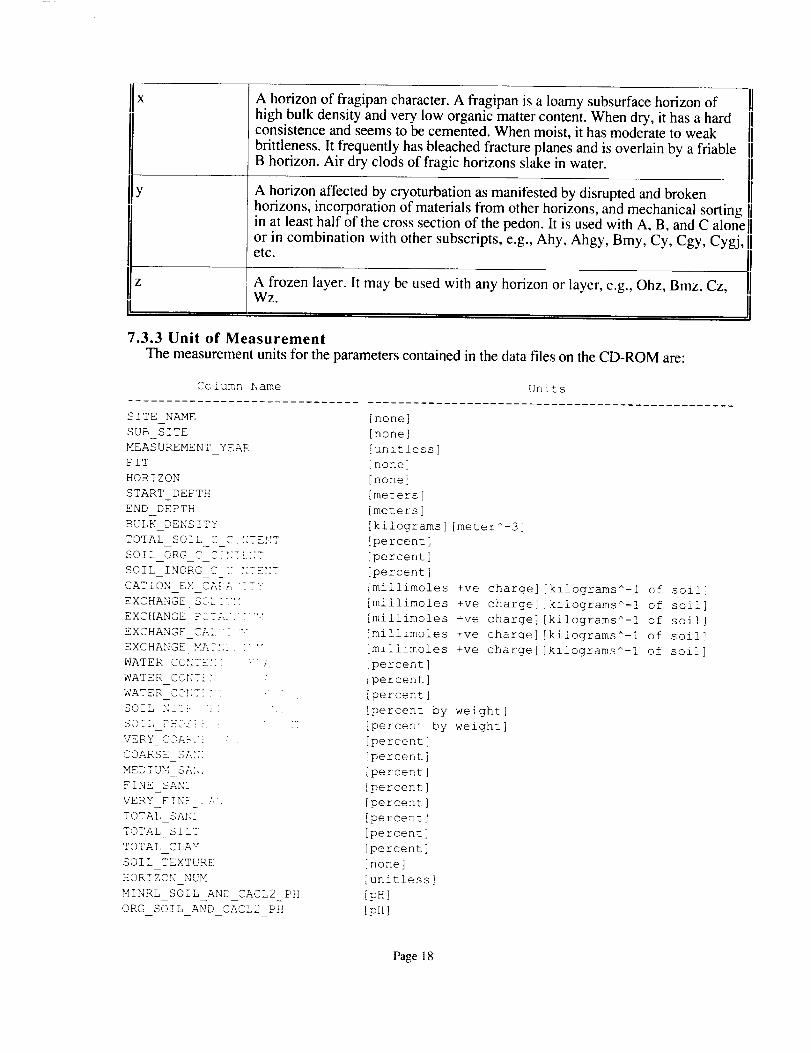
Z i
A horizon of fragipan character. A fragipan is a loamy subsurface horizon ofhigh bulk density and very low organic matter content. When dry, it has a hardconsistence and seems to be cemented. When moist, it has moderate to weak
brittleness. It frequently has bleached fracture planes and is overlain by a friableB horizon. Air dry clods of fragic horizons slake in water.
A horizon affected by cryoturbation as manifested by disrupted and broken
horizons, incorporation of materials from other horizons, and mechanical sorting 1]in at least half of the cross section of the pedon. It is used with A, B, and C alonel]or in combination with other subscripts, e.g., Ahy, Ahgy, Bmy, Cy, Cgy, Cygj, II tc. IIA frozen layer. It may be used with any horizon or layer, e.g., Ohz, Bmz, Cz, ]1
wz II7.3.3 Unit of Measurement
The measurement units for the parameters contained in the data files on the CD-ROM are:
Column Name Units
..............................................................................
SITE NAME [none]
SUBSITE [none]
MEASUREMENT YEAR [unit!ess]
PIT [none]
HORIZON [none]
START_DEPTH [meters]
END_DEPTH [meters]
BULK_DENSITY [kilograms] [meter^_3]
TOTAL SOIL ..... _"_ [p t]- ...... ._ ercen
SOIL_ORG ,_p t[;;7!.[;7 [percent]
SOIL_INORG C T ::TENT [percent]
CATION EX CA}A '_7': [millimoles +ve charge] [kilograms^-i of soil]
EXCHANGE_S_L:"H [millimoles +ve charge] [kilograms^-! of soil]
EXCHANGE F_T;,.._ "X [millimoles +ve charge] [kilograms^-I of soil]
EXCHANGE_CA1. "..... [millimoles +ve charge] [kilograms^-i of soil]
EXCHANGE MA?_;i. " '" [millimoles +ve charge] [kilograms^-I of soil]
WATER_CONTk_;I -_.. [percent]
WATER _"-:"__ ....... " [percent]
WATER_.CONTi_F- " " [percent]
SOIL_NITF- i_ ' _ [percent by weight]
SOIL PH<S[ }. " '" [percent by weight]
VERY COA_.-! ' , [percent]
COARSE S;.£K [percent]
MEDIUM_SANi [percent]
FINESANS [percent]
VERY_FINE_.;.?, [percent]
TOTAL_SAN[ [percent]
TOTAL_SILq [percent]
TOTAL_CLAY [percent]
SOILTEXTURE [none]
HORIZON_NUM [unitless]
MINRL_SOIL AND_ CACL2 PH [pH]
ORG_SOIL AND_CACL2_PH [pH]
Page 18

MINRL SOIL AND H20 PH [pH]
ORG SOIL AND H20 PH [pHI
SOIL EXTRACT ACIDITY [millimoles] [kilogram^-l]
SOIL SULFUR CONTENT [percent by weight]
CRTFCN CODE [none]
REVISION DATE [DD-MON-YY]
7.3.4 Data Source
The sources of the parameter values contained in the data files on the CD-ROM are:
Column Name Data Source
SITE NAME
SUB SITE
MEASUREMENT YEAR
PIT
HORIZON
START DEPTH
END DEPTH
BULK DENSITY
TOTAL SOIL C CONTENT
SOIL ORG C CONTENT
SOIL INORG C CONTENT
CATION EX CAPACITY
EXCHANGE SODIUM
EXCHANGE POTASSIUM
EXCHANGE CALCIUM
EXCHANGE MAGNESIUM
WATER CONTENT 10KPA
WATER CONTENT 33KPA
WATER CONTENT 1500KPA
SOIL NITROGEN--CONTENT
SOIL PHOSPHORUS CONTENT
VERY COARSE SAND
COARSE SAND
MEDIUM SAND
FINE SAND
VERY FINE SAND
TOTAL SAND
TOTAL SILT
TOTAL CLAY
SOIL TEXTURE
HORIZON NUM
MINRL SOIL AND CACL2 PH
ORG SOIL AND CACL2 PH
MINRL SOIL AND H20 PH
ORG SOIL AND H20 PH
SOIL EXTRACT ACIDITY
SOIL SULFUR CONTENT
CRTFCN CODE
REVISION DATE
[Assigned by BORIS]
[Assigned by BORIS]
[Supplied by Investigator]
[Supplied by Investigator]
[Supplied by Investigator]
[Supplied by Investigator]
[Supplied by Investigator]
[Supplied by Investigator]
[Supplied by Investigator]
[Supplied by Investigator]
[Supplied by Investigator]
[Supplied by Investigator]
[Supplied by Investigator]
[Supplied by Investigator]
[Supplied by Investigator]
[Supplied by Investigator]
[Supplied by Investigator]
[Supplied by Investigator]
[Supplied by Investigator]
[Supplied by Investigator]
[Supplied by Investigator]
[Supplied by Investigator]
[Supplied by Investigator]
[Supplied by Investigator]
[Supplied by Investigator]
[Supplied by Investigator]
[Supplied by Investigator]
[Supplied by Investigator]
[Supplied by Investigator]
[Supplied by Investigator]
[Supplied by Investigator]
[Supplied by Investigator]
[Supplied by investigator]
[Supplied by Investigator]
[Supplied by Investigator]
[Supplied by Investigator]
[Supplied by Investigator]
[Assigned by BORIS]
[Assigned by BORIS]
Page 19

7.3.5 Data Range
The following table gives information about the parameter values found in the dam files on theCD-ROM.
Minimum Maximum Missng Unrel Below Data
Data Data Data Data Detect Not
Column Name Value Value Value Value Limit Cllctd
................................................................................
SITE NAME NSA-9BS-9TETR NSA-YJP-FLXTR None None None None
SUB SITE 9TE20-SOL01 9TE20-SOL09 None None None None
MEASUREMENT_YEAR 1994 1994 None None None None
PIT 1 9 None None None None
HORIZON 2AE OMZ4 None None None None
STARTDEPTH -65 495 None None None Blank
ENDDEPTH -34 495 -999 None None Blank
BULK_DENSITY 0 1640 -999 None None None
TOTAL SOIL C CONTENT .03 50.46 None None None None
SOIL_ORG C CONTENT 0 50.46 None None None None
SOIL_INORG C CONTENT 0 29.96 None None None None
CATION EX CAPACITY .5 193.5 -999 None None None
EXCHANGE SODIUM 0 .4 -999 None None None
EXCHANGE_POTASSIUM 0 2.8 -999 None None None
EXCHANGE_CALCIUM 0 160.9 -999 None None None
EXCHANGE_MAGNESIUM 0 25.6 -999 None None None
WATER_CONTENT_IOKPA 0 763.3 None None None None
WATER_CONTENT_33KPA 0 289.3 -999 None None None
WATER CONTENT 0 222.4 -999 None None None
1500KFA
SOIL NITROGEN_ .00! 2.523 None None None None
CONTENT
SOIL PHOSPHORUS_ 0 0 None None None None
CONTENT
VERY_COARSE_SAND -.2 55 3 -999 None None Blank
COARSE_SAND 0 71 4 -999 None None None
MEDIUM_SAND @ 45 5 -999 None None None
FINE_SAND 0 79 8 -999 None None None
VERY FINE SAND 0 12 8 -999 None None None
TOTAL_SAND 0 99 7 -999 None None None
TOTAL SILT 0 70 9 -999 None None None
TOTAL CLAY 0 97 7 -999 None None None
SOIL_TEXTURE N/A N/A None None None Blank
HORIZON_NUM 01 13 None None None None
MINRL SOIL_AND_CACL2_ 0 7.7 None None None None
PH
ORG_SOIL_AND_CACL2_ 0 6.6 None None None None
PH
MINRL SOIL_AND_H20_ 0 8.3 None None None None
PH
ORG SOIL AND H20_PH 0 7.1 None None None None
SOIL_EXTRACT_ACIDITY 0 137.2 -999 None None None
SOIL_SULFUR_CONTENT 0 0 None None None None
CRTFCN_CODE CPI CPI None None None None
REVISION DATE 19-NOV-96 19-NOV-96 None None None None
........................................................................
Minimum Data Value -- The minimum value found in the column.
Page 20

Maximum Data Value --
Missng Data Value --
Unrel Data Value --
Below Detect Limit --
Data Not Cllctd --
The maximum value found in the column.
The value that indicates missing data. This is used to
indicate that an attempt was made to determine the
parameter value, but the attempt was unsuccessful.
The value that indicates unreliable data. This is used
to indicate an attempt was made to determine the
parameter value, but the value was deemed to be
unreliable by the analysis personnel.
The value that indicates parameter values below the
instruments detection limits. This is used to
indicate that an attempt was made to determine the
parameter value, but the analysis personnel determined
that the parameter value was below the detection
limit of the instrumentation.
This value indicates that no attempt was made to
determine the parameter value. This usually
indicates that BORIS combined several similar but
not identical data sets into the same data base table
but this particular science team did not
measure that parameter.
Blank --
N/A --
None --
Indicates that blank spaces are used to denote that type of value.
Indicates that the value is not applicable to the respective column.
Indicates that no values of that sort were found in the column.
7.4 Sample Data RecordThe following are wrapped versions of data records from a sample data file on the CD-ROM.
SITE NAME,SUB SITE,MEASUREMENT YEAR, PIT,HORIZON, START DEPTH, END DEPTH,
BULK DENSITY,TOTAL SOIL C CONTENT,SOIL ORG C CONTENT,SOIL INORG C CONTENT,
CATION EX CAPACITY,EXCHANGE SODIUM,EXCHANGE POTASSIUM, EXCHANGE CALCIUM,
EXCHANGE MAGNESIUM, WATER CONTENT 10KPA, WATER CONTENT 33KPA,WATER CONTENT 1500KPA,
SOIL NITROGEN CONTENT,SOIL PHOSPHORUS CONTENT,VERY COARSE SAND,COARSE SAND,
MEDIUM SAND,FINE SAND,VERY FINE SAND, TOTAL SAND, TOTAL SILT, TOTAL CLAY,
SOIL TEXTURE,HORIZON NUM,MINRL SOIL AND CACL2 PH,ORG SOIL AND CACL2 PH,
MINRL SOIL AND H20 PH, ORG SOIL AND H20 PH,SOIL EXTRACT ACIDITY,
SOIL SULFUR CONTENT,CRTFCN CODE,REVISION DATE
'NSA-9BS-9TETR', '9TE20-SOL01', '1994', 'i', 'CK',62.0,I00.0,-999,22.73, .47,22.26,
19.4, .2, .4,19.4,3.1,4].9,35.9,21.4, .035,0.0,-999.0,-999.0,-999.0,-999.0,-999.0,
.6,34.4,65.0, 'HC', '08',7.6,0.0,8.3,0.0,0.0,0.0, 'CPI',I9-NOV-96
'NSA-9BS-9TETR', '9TE20-SOL01', '1994', 'I' 'L' -9 0 -7 0 50 32 16 32 16 0 0 -999 0r , • , - ¢ ¢ . , . , . , • t
-999.0,-999.0,-999.0,-999.0, 0.0,-999.0,-999.0, .879, 0.O,0.0,0.0,0.0, 0.0,0.0,0.0,
0.0,0.0, '', '01',@.0, 6.0, 0.@,6.5,-999.0,0.0, 'CPI', 19-NOV-96
8. Data Organization
8.1 Data GranularityThe smallest amount of data that can be ordered from this data set is the entire data set from all soil
pits at the NSA sites.
Page 21
8.2 Data Format(s)The Compact Disk-Read-Only Memory (CD-ROM) files contain American Standard Code for
Information Interchange (ASCII) numerical and character fields of varying length separated bycommas. The character fields are enclosed with single apostrophe marks. There are no spaces betweenthe fields.
Each data file on the CD-ROM has four header lines of Hyper-Text Markup Language (HTML)code at the top. When viewed with a Web browser, this code displays header information (data settitle, location, date, acknowledgments, etc.) and a series of HTML links to associated data files and
related data sets. Line 5 of each data file is a list of the column names, and line 6 and following linescontain the actual data.
9. Data Manipulations
9.1 Formulae
None given.
9.1.1 Derivation Techniques and AlgorithmsNot applicable.
9.2 Data Processing Sequence
9.2.1 Processing StepsNone given.
9.2.2 Processing ChangesNone given.
9.3 Calculations
9.3.1 Special Corrections/AdjustmentsNone given.
9.3.2 Calculated VariablesNone.
9.4 Graphs and PlotsNone.
10. Errors
10.1 Sources of Error
Most errors incurred would be due to the heterogeneity of soils and to equipment precision, all ofwhich would be within the limits required for the use of these data.
10.2 Quality Assessment
The soil survey was performed by a soil expert who has many years of soil survey fieldexperience. As a result, there is a great deal of confidence in the field visual observations and in the
quality of soil samples brought into the lab for analysis. All methods for measuring soil characteristicshave been performed routinely in the soil survey division of the Centre for Land and BiologicalResources Research. All methods have been tested thoroughly for accuracy, accepted for the generalsoil survey of Saskatchewan, and approved at the federal research level.
Page 22

10.2.1 Data Validation by SourceNone given.
10.2.2 Confidence Level/Accuracy JudgmentSee Section 10.2.
10.2.3 Measurement Error for Parameters
The error ranges for most of the parameters are as follows:• pH: 5%• Bulk Density: 5%• TC and IC: 3%
• Total Nitrogen and Phosphorus: 5%• EC and CEC: 5%
• Exchangeable H+: 10%• Soil Moisture Retentions (0.3, 0.1, and 15 arm): 5%• Particle Size Fractions: 5%
10.2.4 Additional Quality AssessmentsNone.
10.2.5 Data Verification by Data CenterA cursory review of the data was made to ensure that the data were as expected. Some spot checks
were made to confirm that the data were within the realm of possibility. The data were checked afterloading into the relational data base to ensure that no errors occurred during loading.
11.1 Limitations of the Data
None given.
11.2 Known Problems with the Data
None given.
11.3 Usage GuidanceNone given.
11.4 Other Relevant InformationNone.
1 1. Notes
12. Application of the Data Set
This data set was created for use by BOREAS investigators to use in ecological models and otherresearch purposes.
None.
13. Future Modifications and Plans
Page 23

14. Software
14.1 Software DescriptionNone.
14.2 Software AccessNone.
15. Data Access
The NSA soil lab data are available from the Earth Observing System Data and Information System(EOSDIS) Oak Ridge National Laboratory (ORNL) Distributed Active Archive Center (DAAC).
15.1 Contact Information
For BOREAS data and documentation please contact:
ORNL DAAC User Services
Oak Ridge National LaboratoryP.O. Box 2008 MS-6407
Oak Ridge, TN 37831-6407Phone: (423) 241-3952Fax: (423) 574-4665
E-mail: [email protected] or [email protected]
15.2 Data Center Identification
Earth Observing System Data and Information System (EOSDIS) Oak Ridge National Laboratory(ORNL) Distributed Active Archive Center (DAAC) for Biogeochemic',d Dynamicshttp://www-eosdis.ornl.gov.
15.3 Procedures for Obtaining Data
Users may obtain data directly through the ORNL DAAC online search and order systemlhttp://www-eosdis.ornl.gov/] and the anonymous FFP site [ftp://www-eosdis.ornl.gov/data/] or bycontacting User Services by electronic mail, telephone, fax, letter, or personal visit using the contactinformation in Section 15.1.
15.4 Data Center Status/Plans
The ORNL DAAC is the primary source for BOREAS field measurement, image, GIS, andhardcopy data products. The BOREAS CD-ROM and data referenced or listed in inventories on theCD-ROM are available from the ORNL DAAC.
16. Output Products and Availability
16.1 Tape ProductsNone.
16.2 Film ProductsNone.
16.3 Other ProductsThese data are available on the BOREAS CD-ROM series.
Page 24

17. References
17.i Platform/Sensor/Instrument/Data Processing Documentation
Manual on Soil Sampling and Methods of Analysis. 1978. J.A. MckKeague (Ed). Canadian SoilScience Society.
Technicon Industrial Systems. 1973. Nitrate and nitrite in water and waste water. Industrial MethodNo. 100-70W. Technicon Industrial Systems, Tarrytown, NY.
17.2 Journal Articles and Study ReportsMurphy, J. and J.P. Riley. 1962. A modified single solution method for determination of phosphate innatural waters. Anal. Chim. Acta. 27:31-36.
Newcomer, J., D. Landis, S. Conrad, S. Curd, K. Huemmrich, D. Knapp, A. Morrell, J. Nickeson,A. Papagno, D. Rinker, R. Strub, T. Twine, F. Hall, and P. Sellers, eds. 2000. Collected Data of TheBoreal Ecosystem-Atmosphere Study. NASA. CD-ROM.
Sellers, P. and F. Hall. 1994. Boreal Ecosystem-Atmosphere Study: Experiment Plan. Version1994-3.0, NASA BOREAS Report (EXPLAN 94).
Sellers, P. and F. Hall. 1996. Boreal Ecosystem-Atmosphere Study: Experiment Plan. Version1996-2.0, NASA BOREAS Report (EXPLAN 96).
Sellers, P., F. Hall, and K.F. Huemmrich. 1996. Boreal Ecosystem-Atmosphere Study: 1994Operations. NASA BOREAS Report (OPS DOC 94).
Sellers, P., F. Hall, and K.F. Huemmrich. 1997. Boreal Ecosystem-Atmosphere Study: 1996
Operations. NASA BOREAS Report (OPS DOC 96).
Sellers, P., F. Hall, H. Margolis, B. Kelly, D. Baldocchi, G. den Hartog, J. Cihlar, M.G. Ryan, B.Goodison, P. Crill, K.J. Ranson, D. Lettenmaier, and D.E. Wickland. 1995. The boreal
ecosystem-atmosphere study (BOREAS): an overview and early results from the 1994 field year.Bulletin of the American Meteorological Society. 76(9): 1549-1577.
Sellers, P.J., F.G. Hall, R.D. Kelly, A. Black, D. Baldocchi, J. Berry, M. Ryan, K.J. Ranson, P.M.Crill, D.P. Lettenmaier, H. Margolis, J. Cihlar, J. Newcomer, D. Fitzjarrald, P.G. Jarvis, S.T.Gower, D. Halliwell, D. Williams, B. Goodison, D.E. Wickland, and F.E. Guertin. 1997. BOREASin 1997: Experiment Overview, Scientific Results and Future Directions. Journal of GeophysicalResearch 102(D24): 28,73 !-28,770.
Soil Classification Working Group (Eds.). 1998. The Canadian System of Soil Classification. 3rdedition. Agriculture and Agri-Food Canada Publication 1646. 187 pp. Research Branch, Agricultureand Agri-Food Canada, National Research Council of Canada, Ottawa, Ontario.
Thomas, R.L., R.W. Sueurd, and J.P. Moyer. 1967. Comparison of conventional and automatedprocedures for nitrogen, phosphorus and potassium analysis of plant material using a single digest.Agron. J. 99: 240-243.
Tiessen, H., T.L. Roberts, and J.W.B. Stewart. 1983. Carbonate analysis in soils and minerals byacid digestion and two-endpoint titration. Commun. Soil Sci. Plant Anal. 14:161 - 166.
Veldhuis, H. 1995. Soils of Tower Sites and Super Site, Northern Study Area, Thompson, Manitoba,Canada. BOREAS Project Soils Report for NSA.
Page 25

Veldhuis, H. and G. Rapalee. 1999. Soil carbon stocks and distribution in soil and landscapes of theGlacial Lake Agassiz basin, north-central Manitoba. In Proceedings of42nd Annual Manitoba SoilScience Society Meeting, Winnipeg MB. 181-188.
17.3 Archive/DBMS Usage DocumentationNone.
None.
18. Glossary of Terms
AEAC
ASCII
BOREAS
BORIS
CD- ROM
CEC
DAAC
EC
EOS
EOSD i S
:SIS
_SFC
HTHL
HSA
NASA
MIST
NSA
OA
,OBS
OC
£ JP
C' R N L
FAN F
r
SSA
TE
TGB
T_RL
y 7 P
19. List of Acronyms
- Albers Equal-Area Conic
- American Standard Code for Information Interchange
- BOReal Ecosystem-Atmosphere Study
- BOREAS Information System
- Compact Disk-Read-Only Memory
- Cation Exchange Capacity
- Distributed Active Archive Center
- Elec_ric Conductivity
- Earth Observing System
- EOS Data and Information System
- Geographic Information System
- Goddard Space Flight Center
- HyperText Markup Language
- Inorganic Carbon
- Modeling Sub-Area
- National Aeronautics and Space Administration
- National Institute of Standards and Technology
- Northern Study Area
- Old Aspen
- Old Black Spruce
- Organic Carbon
Old Jack Pine
Oak Ridge National Laboratory
- Prince Albert National Park
- Principal Investigator
- Southern Study Area
- Total Carbon
- Terrestrial Ecology
- Trace Gas Biogeochemistry
- Uniform Resource Locator
- Young Jack Pine
Page 26

20. Document Information
20.1 Document Revision DateWritten: 01 -Jan- 1997
Last Revised: 11-Aug- 1999
20.2 Document Review Date(s)
BORIS Review: 20-Aug- 1998Science Review: 14-Jul- 1998
20.3 Document ID
20.4 Citation
Please contact Hugo Veldhuis before publishing any results that are based on these data. Also,please include citations of relevant papers in Section 17.2.
If using data from the BOREAS CD-ROM series, also reference the data as:Veldhuis, H., "Soils of Tower Sites and Super Site, Northern Study Area, Thompson, Manitoba,
Canada." In Collected Data of The Boreal Ecosystem-Atmosphere Study. Eds. J. Newcomer, D.Landis, S. Conrad, S. Curd, K. Huemmrich, D. Knapp, A. Morrell, J. Nickeson, A. Papagno, D.Rinker, R. Strub, T. Twine, F. Hall, and P. Sellers. CD-ROM. NASA, 2000.
Also, cite the BOREAS CD-ROM set as:Newcomer, J.. D. Landis, S. Conrad, S. Curd, K. Huemmrich, D. Knapp, A. Morrell, J.
Nickeson, A. Papagno. D. Rinker, R. Strub, T. Twine, F. Hall, and P. Sellers, eds. Collected Data ofThe Boreal Ecosystcm-Atmosphere Study. NASA. CD-ROM. NASA, 2000.
20.5 Documen! Curator
20.6 Documenl i'Rl.
Page 27

REPORT DOCUMENTATION PAGEForm Approved
OMB No. 0704o0188
Public reporting burden for this collectionof information is estimated to average 1 hour per response, including the time for reviewinginstructions, searching existing data sources,gathering and maintaining the data needed, and completingand reviewing the collection of information Send comments regarding this burden estimate orany other aspect of thiscollectionof information, including suggestions for reducing this burden, to Washington Headquarters Services, Directoratefor Information Operations and Reports, 1215 JeffersonDavis Highway, Suite 1204, Arlington,VA 22202-4302, and to the Office of Managementand Budget, Paperwork Reduction Project (0704-0188), Washington, DC 20503
1. AGENCY USE ONLY (Leave blank) 2. REPORT DATE | 3. REPORT TYPE AND DATES COVERED
October 2000 I Technical Memorandum4. TITLE AND SUBTITLE
Technical Report Series on the Boreal Ecosystem-Atmosphere Study (BOREAS)
BOREAS TE-20 NSA Soil Lab Data
6. AUTHOR(S)
Hugo Veldhuis
Forrest G. Hall and David E. Knapp, Editors
7. PERFORMING ORGANIZATION NAME(S) AND ADDRESS (ES)
Goddard Space Flight Center
Greenbelt, Maryland 20771
9. SPONSORING/ MONITORINGAGENCYNAME(S)AND ADDRESS(ES)
National Aeronautics and Space Admin!strationWashington, DC 20546-0001
5. FUNDING NUMBERS
923
RTOP: 923-462-33-01
8. PEFORMING ORGANIZATION
REPORT NUMBER
2000-03136-0
10. SPONSORING / MONITORINGAGENCY REPORT NUMBER
TM--20(0)-20989 l
Vol. 183
11. SUPPLEMENTARY NOTES
H. Veldhuis: University of Manitoba, Winnipeg;
D.E. Knapp: Raytheon ITSS, NASA Goddard Space Flight Center, Greenbelt, Maryland
12a. DISTRIBUTION / AVAILABILITY STATEMENT 12b. DISTRIBUTION CODE
Unclassified-Unlimited
Subject Category: 43
Report available from the NASA Center for AeroSpace Information,
7121 Standard Drive, Hanover, MD 21076-1320. (301) 621-0390.
13. ABSTRACT (Maximum 200 words)
This data set contains the major soil properties of soil samples collected in 1994 at the tower flux sites in the
NSA. The soil samples were collected by Hugo Veldhuis and his staff from the University of Manitoba. Themineral soil samples were largely analyzed by Barry Goetz, under the supervision of Dr. Harold Rostad at the
University of Saskatchewan. The organic soil samples were largely analyzed by Peter Haluschak, under the
supervision of Hugo Veldhuis at the Centre for Land and Biological Resources Research in Winnipeg,
Manitoba. During the course of field investigation and mapping, selected surface and subsurface soil samples
were collected for laboratory analysis. These samples were used as benchmark references for specific soilattributes in general soil characterization. Detailed soil sampling, description, and laboratory analysis were
performed on selected modal soils to provide examples of common soil physical and chemical characteristics inthe study area. The soil properties that were determined include soil horizon; dry soil color; pH; bulk density;
total, organic, and inorganic carbon; electric conductivity; cation exchange capacity; exchangeable sodium,
potassium, calcium, magnesium, and hydrogen; water content at 0.01,0.033, and 1.5 MPascals; nitrogen;
phosphorus: particle size distribution; texture; pH of the mineral soil and of the organic soil; extractable acid;and sulfur. These data are stored in ASCII text files.
14. SUBJECT TERMS
BOREAS, terrestrial ecology, soil properties.
17. SECURITY CLASSIFICATION
OF REPORT
Unclassified
NSN 7540-01-280-5500
18. SECURITY CLASSIFICATIONOF THIS PAGE
Unclassified
19. SECURITY CLASSIFICATIONOF ABSTRACT
Unclassified
15. NUMBER OF PAGES
2716. PRICE CODE
20. LIMITATION OF ABSTRACT
UL
Standard Form 298 (Rev. 2-89)Prescribedby ANSI Std. Z39.18298-102