navigational risk hazid workshop appendix 2 name: navigational risk hazid workshop det norske...
TRANSCRIPT

NAVIGATIONAL RISK HAZID WORKSHOP
Appendix 2 Washington State Ferries
Report No.: PP061307-2, Rev. 02 Document No.: 167NWYK-13 Date: 2014-06-16

Project name: Navigational Risk HAZID Workshop Det Norske Veritas (U.S.A.), Inc.
DNV GL Oil & Gas Risk Advisory Services 1400 Ravello Dr Suite 100 77449 Katy TX United States Tel: +1 281 396 1000
Report title: Appendix 2 Customer: Washington State Ferries, Contact person: Darnell Baldinelli Date of issue: 2014-06-16 Project No.: PP061307 Organisation unit: Risk Advisory Services Report No.: PP061307-2, Rev. 02 Document No.: 167NWYK-13
DNV GL – Report No. PP061307-2, Rev. 02 – www.dnvgl.com Page i
Abbreviations
AIS Automated Information System
BC British Columbia
DNV Det Norske Veritas
HAZID Hazard Identifiation (workshop)
HC Hydrocarbon
LNG Liquefied Natural Gas
PSE Puget Sound Energy
SMS Safety Management System
USCG United States Coast Guard
VTS Vessel Traffic Services
WSDOT Washington State Department of Transportation
WSF Washington State Ferries
DNV GL – Report No. PP061307-2, Rev. 02 – www.dnvgl.com Page ii

Table of contents
1 INTRODUCTION .............................................................................................................. 2
2 HAZID WORKSHOP ......................................................................................................... 3 2.1 Scope 3 2.2 Participants 10 2.3 Guidance on Hazard Identification 11
3 HAZID FINDINGS .......................................................................................................... 12 3.1 General Findings 12
4 HAZID WORKSHEETS .................................................................................................... 14 4.1 Anacortes/San Juan Islands/Sidney 14 4.2 Seattle/Bremerton 16 4.3 Mukilteo/Clinton 17 4.4 Fauntleroy/Vashon/Southworth 18 4.5 Edmonds/Kingston 19 4.6 Eagle Harbor Approach Including Environmental 20
5 HAZAD CONCLUSIONS .................................................................................................. 21
DNV GL – Report No. PP061307-2, Rev. 02 – www.dnvgl.com Page i

1 INTRODUCTION DNV conducted a navigational risk assessment to obtain stakeholder input for the safety and security assessment. As part of the navigational risk assessment, a navigation HAZID workshop was held in Seattle, February 13, 2013 with local maritime experts to identify local hazards related to the ferry routes and to assess how the hazards could influence risk.
A navigation HAZID workshop utilizes a systematic approach to identify hazards and assessment of associated risks in order to provide information to aid decision making concerning the need for risk reduction measures.
Results of the navigation HAZID helped establish relevant probability values for accidental incidents along the sailing route and at the terminal. Existing safeguards and barriers were identified as well as needs for risk reducing measures.
have the potential to materially change the outcome of the results.
DNV GL – Report No. PP061307-2, Rev. 02 – www.dnvgl.com Page 2

2 HAZID WORKSHOP A Hazard Identification Study (HAZID) is the process of identifying hazards in order to plan for, avoid, or mitigate their impacts. Hazard identification is an important step in risk assessment and risk management.
Therefore the navigation HAZID workshop was a key step and provided risk assessors important local knowledge about the sailing route, highlighting particular navigational challenges along the sailing route and approaches to the terminals.
2.1 Scope The scope was defined in terms of both geographic extent and incident type.
2.1.1 Geographic All the evaluated ferry routes are shown in Figure 2-1 to Figure 2-3. The geographic boundary for the HAZID workshop was the following ferry routes:
• Anacortes, Washington - San Juan Islands, Washington – Sidney, British Columbia, Figure 2-4 to Figure 2-6
• Seattle, Washington – Bremerton, Washington, Figure 2-7
• Mukilteo, Washington – Clinton, Figure 2-8
• Vashon, Washington – Fauntleroy, Washington, Figure 2-9
• Edmonds, Washington – Kingston, Washington, Figure 2-10
• Eagle Harbor approach, not shown in a dedicated figure
DNV GL – Report No. PP061307-2, Rev. 02 – www.dnvgl.com Page 3

Figure 2-1 Route Segments Schematic
DNV GL – Report No. PP061307-2, Rev. 02 – www.dnvgl.com Page 4

Figure 2-2 Route Segments Southern Portion
DNV GL – Report No. PP061307-2, Rev. 02 – www.dnvgl.com Page 5

Figure 2-3 Route Segments Northern Portion
Figure 2-4 Anacortes/Lopez Route
DNV GL – Report No. PP061307-2, Rev. 02 – www.dnvgl.com Page 6

Figure 2-5 San Juan Islands Ferry Routes
Figure 2-6 Friday Harbor/Sidney Ferry Route
DNV GL – Report No. PP061307-2, Rev. 02 – www.dnvgl.com Page 7

Figure 2-7 Seattle/Bremerton Ferry Route
Figure 2-8 Mukilteo- Clinton Ferry Route
•
DNV GL – Report No. PP061307-2, Rev. 02 – www.dnvgl.com Page 8
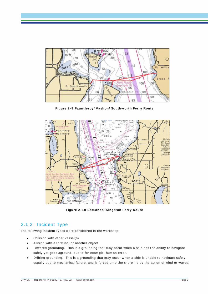
Figure 2-9 Fauntleroy/Vashon/Southworth Ferry Route
Figure 2-10 Edmonds/Kingston Ferry Route
2.1.2 Incident Type The following incident types were considered in the workshop:
• Collision with other vessel(s) • Allision with a terminal or another object • Powered grounding. This is a grounding that may occur when a ship has the ability to navigate
safely yet goes aground, due to for example, human error. • Drifting grounding. This is a grounding that may occur when a ship is unable to navigate safely,
usually due to mechanical failure, and is forced onto the shoreline by the action of wind or waves.
DNV GL – Report No. PP061307-2, Rev. 02 – www.dnvgl.com Page 9

2.2 Participants A HAZID participant group was assembled of 24 local experts who were knowledgeable about the study area. Members of the team had experience in piloting, escorting, and conning vessels within WSF’s ferry network and working on marine projects in the Seattle and coastal areas. The participants’ experience covered a wide range of maritime background and detailed knowledge about the area. The participant group was appropriate to assess the hazards involved in navigation in the area.
Table 2-1 List of Navigational HAZID Participants
Name Company Position E-mail
Peter Hoffmann DNV Facilitator [email protected]
Per Sollie DNV Scribe / Project Manager [email protected]
Christopher Lanza DNV Security Analyst [email protected]
Mark Ashley USCG VTS Director [email protected]
Greg Peterson BC Ferries Director, Fleet Performance [email protected]
Brad Judson BC Ferries Manager, SMS [email protected]
Cotty Fay WSF Chief Naval Architect [email protected]
Parrek Kimmerly WSF Vessel Master [email protected]
John Veentjer MXPS Director [email protected]
Torn Larsen FAC Member, Ferry Advisory Committee [email protected]
Chip Boothe DOE Spill Prevention Response Manager [email protected]
Jonathan Ward PSP President [email protected]
Gretchen Bailey USCG CID [email protected]
John Dwyer USCG OCMI [email protected]
Lindsay Cook USCG Inspector [email protected]
Vern Day WSF Sr. Port Engineer [email protected]
Steven Hopkins WSF Staff Master [email protected]
Rand Lymangrover Tote Terminal Manger [email protected]
John Dwyer USCG OCMI [email protected]
Noel Brady WSDOT Communications [email protected]
Carol Lee Roalkvam WSDOT WSDOT Policy Branch Manager [email protected]
Kelly Mitchell WSF Sr. Port Captain [email protected]
Sheila Helgath WSF Environmental Program Manager [email protected]
Darnell Baldinelli WSF Safety Systems Engineer [email protected]
DNV GL – Report No. PP061307-2, Rev. 02 – www.dnvgl.com Page 10
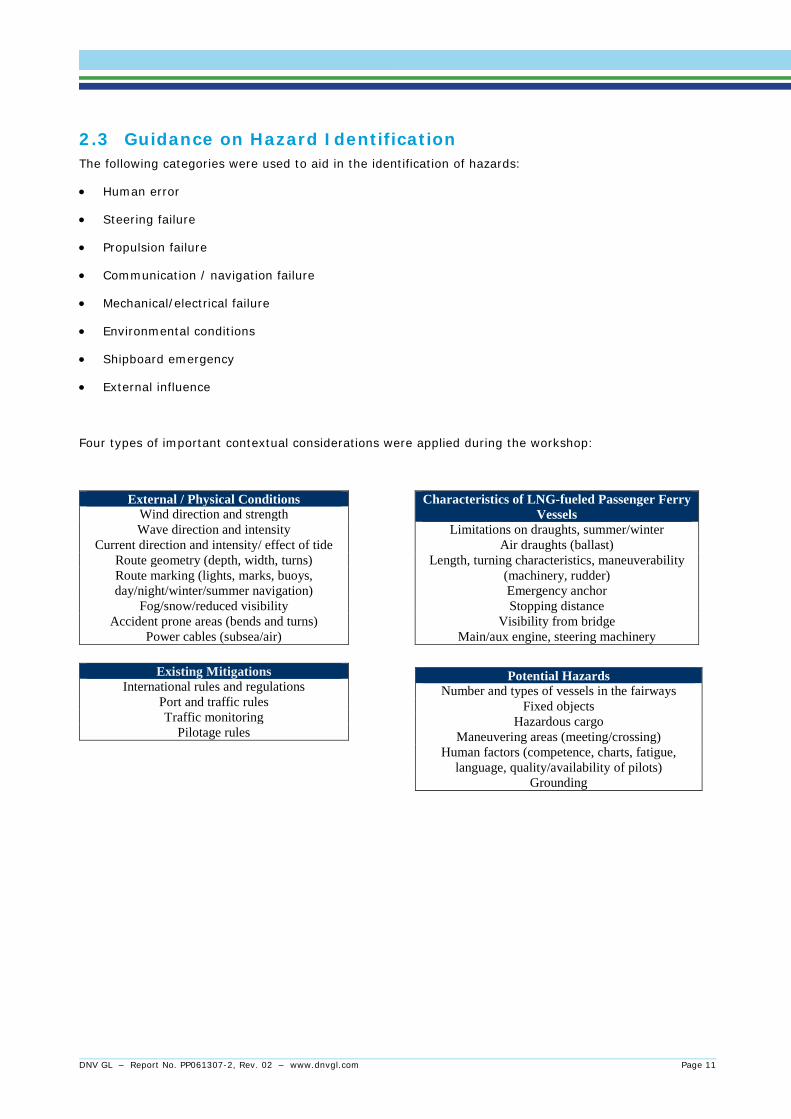
2.3 Guidance on Hazard Identification The following categories were used to aid in the identification of hazards:
• Human error
• Steering failure
• Propulsion failure
• Communication / navigation failure
• Mechanical/electrical failure
• Environmental conditions
• Shipboard emergency
• External influence
Four types of important contextual considerations were applied during the workshop:
External / Physical Conditions Wind direction and strength Wave direction and intensity
Current direction and intensity/ effect of tide Route geometry (depth, width, turns) Route marking (lights, marks, buoys, day/night/winter/summer navigation)
Fog/snow/reduced visibility Accident prone areas (bends and turns)
Power cables (subsea/air)
Characteristics of LNG-fueled Passenger Ferry Vessels
Limitations on draughts, summer/winter Air draughts (ballast)
Length, turning characteristics, maneuverability (machinery, rudder) Emergency anchor Stopping distance
Visibility from bridge Main/aux engine, steering machinery
Existing Mitigations International rules and regulations
Port and traffic rules Traffic monitoring
Pilotage rules
Potential Hazards Number and types of vessels in the fairways
Fixed objects Hazardous cargo
Maneuvering areas (meeting/crossing) Human factors (competence, charts, fatigue,
language, quality/availability of pilots) Grounding
DNV GL – Report No. PP061307-2, Rev. 02 – www.dnvgl.com Page 11

3 HAZID FINDINGS To assist organization of the HAZID discussion, the ferry routes were predefined into sailing route segments:
• Anacortes - San Juan Islands and to British Columbia
• Seattle / Bremerton
• Mukilteo / Clinton
• Vashon / Fauntleroy
• Edmonds / Kingston
• Eagle Harbor approach
Sailing route traffic and type information was provided for each segment. Each segment was discussed; potential hazards identified noting any segment specific causes. Based on the causes, each segment was assigned a rating, in terms of the likelihood of a hazard leading to a grounding or collision incident using the following system:
Much higher than average - H-3 Higher than average - H-2 Average - A-1 Lower than average - L-2 Much lower than average - L-3
Section 3.1 describes the general findings from the HAZID. Sections 3.2 to 3.7 present the HAZID worksheets.
3.1 General Findings The following issues were raised as part of general discussions across the various segments:
• The risk for an allision/collision in Elliot bay (i.e. Seattle – Bremerton route) would be of the highest of all the WSF routes, due to the high traffic density.
• No immediate Hot Wash will be initiated if an incident occurs, however lessons learned after incidents are entered into a WSF database and used to develop training of personnel.
• For situations such as black ship, loss of propulsion etc., tow gear is available on the Ferries in order to get help from tugs or other vessels.
• Emergency anchors will probably not work in most areas due to water depth; however if used they will not be possible to hoisted from the Ferry. This Anchor use would be the last resort in case of a drifting incident.
• All bridges on the ferries are identical similar system wide in configuration and layout for standardization purposes. Thus reducing the time for bridge crew to be aquatinted with equipment if new ferries are entered in a given route. All crews receive route and vessel familiarization training before being assigned to a specific vessel.
• Vessel Captains and Mates generally have years of experience with the vessels and routes to which they are assigned. This experience and local knowledge reduces the potential for human error.
• Sea trials are performed after each overhaul and major maintenance in order to check the maneuverability and functionality of the vessel.
DNV GL – Report No. PP061307-2, Rev. 02 – www.dnvgl.com Page 12

• The WSF ferries have a standing order to avoid a potential collision situation by sailing aft of any ship
which they cannot pass more than 1 nautical mile ahead of ,even if the ferries have the right of way.
• Generally, the primary collision risk is related to crossing the main shipping lanes in the area. These are covered by VTS and the majority (if not all) the commercial traffic using the traffic lanes have a pilot on-board.
• Fishing boats including fishing equipment from local fishermen are seen as an issue concerning navigation of ferries during the fishing season. This is seen as a navigation issue rather than a potential direct cause of an LNG release.
• An allision incident is claimed to occur about every 18 months in the total fleet of ferries, mainly due to the high number of terminal approaches performed by all ferries
• No objects, overhangs, bridges or similar were identified in normal operation which could potentially hit the LNG tank if the ferries got too close
• For the Eagle Harbor site, a short environmental review was discussed regarding emission of gas (venting) and incidental discharges of dry chemicals. WSF will need to investigate the potential regulations and impacts from emissions related to any maintenance activities that could release natural gas.
DNV GL – Report No. PP061307-2, Rev. 02 – www.dnvgl.com Page 13
4 HAZID WORKSHEETS The HAZID Worksheets below document the results and reflect the information gathered in the workshop. Information in [brackets] was added to or removed from the worksheets by comment after the workshop.
4.1 Anacortes/San Juan Islands/Sidney
# Hazard/Description Cause Mitigation R# Comments Anacortes to Lopez
1
Collision with other vessel
Traffic to/from Anacortes terminal
Strict departure rules, VTS special areas, additional traffic measures in place, one way traffic only, procedures tugs and tows, ferries must pass astern deep draft vessels, tank vessels are escorted with tugs, speed limits on tankers 11 knots. AIS.
H-2
Commercial fishing vessels to and from Alaska, Petroleum tankers, tug and tows, dry bulk. Mostly recreational traffic out in the islands.
2
Grounding Harsh weather Short loading, less vehicles in the bow, bringing the bow up to avoid green water
H-2
Obstruction Pass is a "storm route" during heavy weather.
3 Allision Currents right
outside the dock line at Anacortes
Damage to Vessel or Dock H-2
12,000 – 13,000 ferry arrivals per year,
4
Collision Main tanker route passes, minimum 1 tanker a day through Rosario Strait
H-2
Friday Harbor - Orcas
5
Friday Harbor is sheltered, low current, major marina, float planes can be an issue, a lot of condos in Friday Harbor (could be a LNG consequence). In Orcas there is a diesel holding tank.
DNV GL – Report No. PP061307-2, Rev. 02 – www.dnvgl.com Page 14
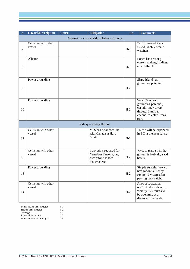
# Hazard/Description Cause Mitigation R# Comments Anacortes - Orcas Friday Harbor - Sydney
7
Collision with other vessel
H-2
Traffic around Shaw Island, yachts, whale watchers
8
Allision
H-2
Lopez has a strong current making landings a bit difficult
9
Power grounding
H-2
Shaw Island has grounding potential
10
Power grounding
H-2
Wasp Pass has grounding potential, captains may divert through San Juan channel to enter Orcas port.
Sidney – Friday Harbor
11
Collision with other vessel
VTS has a handoff line with Canada at Haro Strait H-2
Traffic will be expanded in BC in the near future
12
Collision with other vessel
Two pilots required for Canadian Tankers, tug escort for a loaded tanker as well
H-2
West of Haro strait the ground is basically sand banks.
13
Power grounding
H-2
Simple straight forward navigation to Sidney. Protected waters after passing the straight
14
Collision with other vessel
H-2
A lot of recreation traffic in the Sidney vicinity. BC ferries will be operating at a distance from WSF.
Much higher than average - H-3 Higher than average - H-2 Average - A-1 Lower than average - L-2 Much lower than average - L-3
DNV GL – Report No. PP061307-2, Rev. 02 – www.dnvgl.com Page 15

4.2 Seattle/Bremerton
# Hazard/Description Cause Mitigation R# Comments
1
Collision in Elliot Bay Human error (communications)
AIS, Traffic control, VTS measures, Communications, Traffic separation schemes, 1 nm clearance required
H-2 Seattle is a major terminal, fast ferries, tankers, bulkers, yachts, large marina, [oil and gravel barges,] and cruise ships
2
Grounding in the Rich passage
Steering failure, fog Well marked route, redundant steering gear, front and aft propellers, radar, bow propellers engaged during fog conditions, at limited visibility will post more people on the bridge
H-2 Sounding of fog signal when visibility is less than a mile. Tug response will come out of Seattle, Elliot Bay.
3 Collision with pleasure craft
Human error (communications)
[Lookout, ferry whistle, and loudspeaker]
H-2 Float planes in Elliot Bay could also be an issue.
4
East/West bound Ferry North/South bound deep draft
Human error (communications)
Pilots, increased VTS service, radio communication
H-2 All commercial vessels are required to have a pilot. Coleman dock is assumed to be the highest risk.
5
Collision with Tribal Vessels
Human error (communications)
Protocol on tribal fishing vessels [generally smaller vessels, and are less of a threat], reflective signage on trawling gear
H-2
6
Collision with Military vessel at Rich Pass
Communications [VTS notification in advance by military]
[Naval vessels sometimes escorted]
Much higher than average - H-3 Higher than average - H-2 Average - A-1 Lower than average - L-2 Much lower than average - L-3
DNV GL – Report No. PP061307-2, Rev. 02 – www.dnvgl.com Page 16

4.3 Mukilteo/Clinton
# Hazard/Description Cause Mitigation R# Comments
1 Collision with other vessels
[Human error] [Training, detailed SMS policies and procedures]
L-2 Naval traffic, tugs and tows are the main traffic. 2 vessels per day.
2
Allision [Human error] [Training, detailed SMS policies and procedures]
L-2 Floating dolphin on Mukilteo side. Mukilteo dock will be moved in the next 5 years. Will be more sheltered, but still be a single slip dock. The current issue could be mitigated.
3
Drift grounding [Loss of propulsion]
[Most routes have one or more ferries operating nearby that can render assistance.]
L-2 Spring runoff can create a lot of current
4
Grounding [Human error] [Training, detailed SMS policies and procedures]
L-2 No hard ground, friendly edges. High frequency, 12 min crossing, 15 min loading, three hours downtime at night.
5
Collision with recreational traffic
Ferry traffic, traffic in out of sand heads, congested
VTS monitoring considered adequate
L-2
Much higher than average - H-3 Higher than average - H-2 Average - A-1 Lower than average - L-2 Much lower than average - L-3
DNV GL – Report No. PP061307-2, Rev. 02 – www.dnvgl.com Page 17

4.4 Fauntleroy/Vashon/Southworth
# Hazard/description Cause Mitigation R# Comments
1
Collision/Allision with berth
Human error, lack of knowledge of the vessel or route
SMS procedures, Annual training, Concrete and Steel terminals to withstand shear loads (designed up to 5kts)
A-1
2
Allision with the docks Human error, lack of knowledge of the vessel or route
Where incidents have occurred these have been introduced in the annual training.
A-1 Risk reduction measure: Personnel to attain more familiarity with the vessel and local procedures.
3
Collision with Ferry between Southworth and Vashon with northbound traffic from Tacoma and mainly Olympia
Visibility, Complexity of the schedule, Human error
VTS, AIS, SMS procedures, Pilots
H-2 Deep drafts will be heading to Tacoma. Visibility is usually good. Southbound vessels will be at a lower speed, all Tacoma bound vessels will have pilots onboard. All southbound vessels will be already slowing down. North bound vessels will be at 12 - 15 knots.
4
Grounding Human error, lack of knowledge of the vessel or route
[Training, detailed SMS policies and procedures]
H-2 No immediate Hot Wash after incident. Lessons learned are entered into a WSF database and used to develop training.
Much higher than average - H-3 Higher than average - H-2 Average - A-1 Lower than average - L-2 Much lower than average - L-3
DNV GL – Report No. PP061307-2, Rev. 02 – www.dnvgl.com Page 18
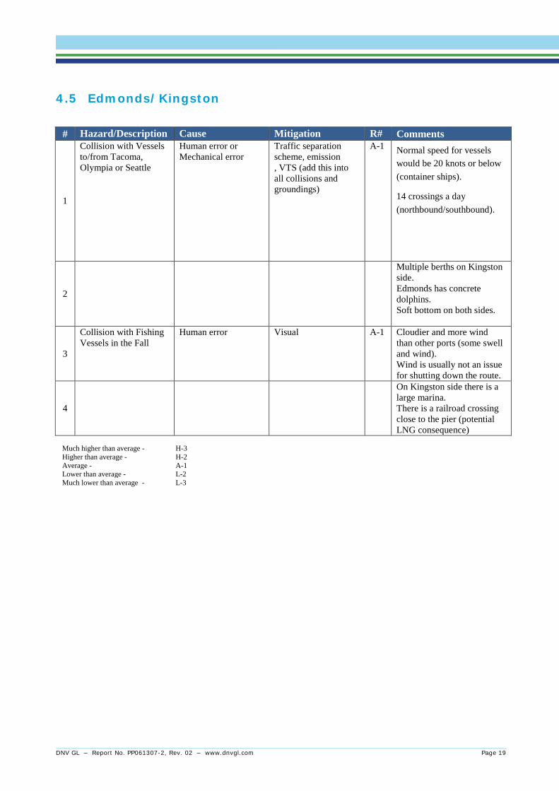
4.5 Edmonds/Kingston
# Hazard/Description Cause Mitigation R# Comments
1
Collision with Vessels to/from Tacoma, Olympia or Seattle
Human error or Mechanical error
Traffic separation scheme, emission , VTS (add this into all collisions and groundings)
A-1 Normal speed for vessels would be 20 knots or below (container ships).
14 crossings a day (northbound/southbound).
2
Multiple berths on Kingston side. Edmonds has concrete dolphins. Soft bottom on both sides.
3
Collision with Fishing Vessels in the Fall
Human error Visual A-1 Cloudier and more wind than other ports (some swell and wind). Wind is usually not an issue for shutting down the route.
4
On Kingston side there is a large marina. There is a railroad crossing close to the pier (potential LNG consequence)
Much higher than average - H-3 Higher than average - H-2 Average - A-1 Lower than average - L-2 Much lower than average - L-3
DNV GL – Report No. PP061307-2, Rev. 02 – www.dnvgl.com Page 19
4.6 Eagle Harbor Approach Including Environmental
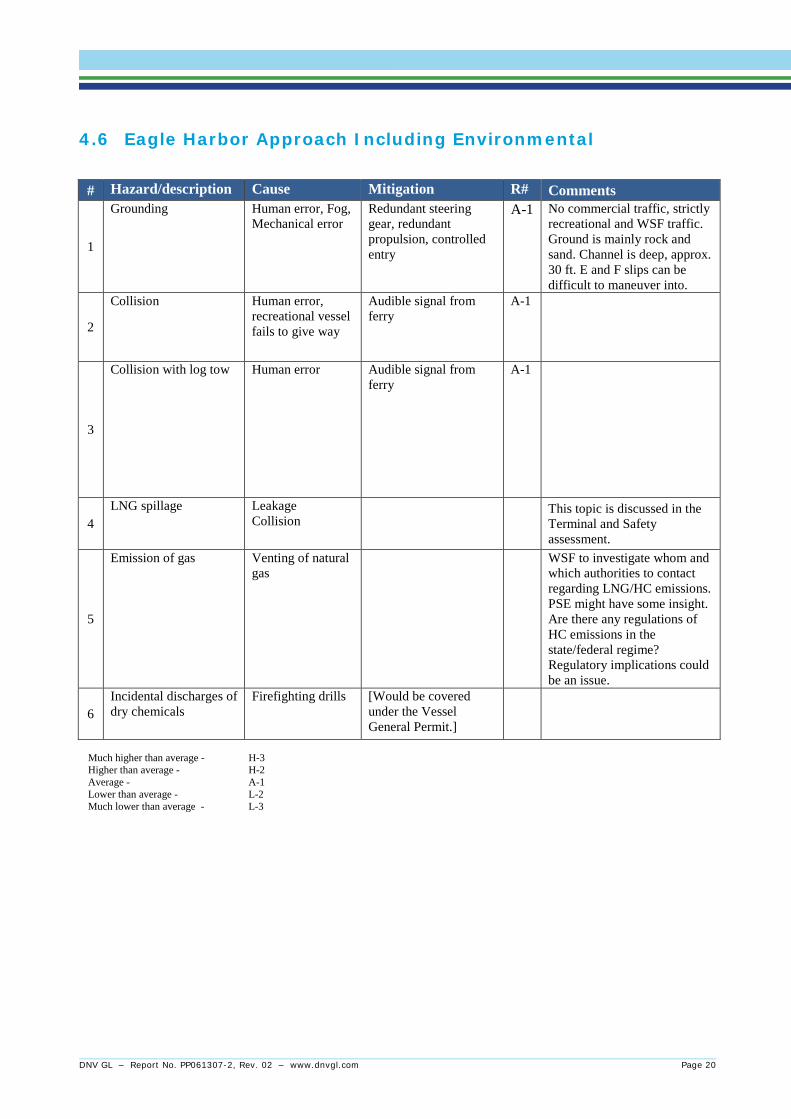
# Hazard/description Cause Mitigation R# Comments
1
Grounding Human error, Fog, Mechanical error
Redundant steering gear, redundant propulsion, controlled entry
A-1 No commercial traffic, strictly recreational and WSF traffic. Ground is mainly rock and sand. Channel is deep, approx. 30 ft. E and F slips can be difficult to maneuver into.
2
Collision Human error, recreational vessel fails to give way
Audible signal from ferry
A-1
3
Collision with log tow Human error Audible signal from ferry
A-1
4 LNG spillage Leakage
Collision This topic is discussed in the
Terminal and Safety assessment.
5
Emission of gas Venting of natural gas
WSF to investigate whom and which authorities to contact regarding LNG/HC emissions. PSE might have some insight. Are there any regulations of HC emissions in the state/federal regime? Regulatory implications could be an issue.
6 Incidental discharges of dry chemicals
Firefighting drills [Would be covered under the Vessel General Permit.]
Much higher than average - H-3 Higher than average - H-2 Average - A-1 Lower than average - L-2 Much lower than average - L-3
DNV GL – Report No. PP061307-2, Rev. 02 – www.dnvgl.com Page 20

5 HAZAD CONCLUSIONS The seven segments were rated overall as follows:
• San Juan Islands and to BC Above average risk due to high level of traffic out of Anacortes and in the Haro Strait as well as the grounding risk around the San Juan Islands
• Seattle – Bremerton Above average risk due to the high density of traffic within the Seattle Harbor area and crossing the main shipping lanes as well as additional grounding risk in Rich Pass
• Mukilteo – Clinton Lower than average risk due to reduced traffic in this area and short route
• Vashon – Fauntleroy Average risk - benign navigational challenges overall
• Edmonds – Kingston Average risk - benign navigational challenges overall
• Eagle Harbor approach Average risk - benign navigational challenges overall
The key observations from the HAZID were as follows
• In the event of a black ship, loss of control or allision, no objects such as cliffs, rock formations, overhung objects such as container cranes, dock cranes or similar were identified during the course of the workshop that could act as a threat of impact on the two top mounted LNG tanks
• The main collision risks are related to crossing of the main shipping lanes. These are covered by VTS in all areas and the WSF ferries have a standing order to pass behind crossing traffic if safe passage more than 1 nautical mile ahead is not possible. In addition, most of the traffic in the shipping lanes will have pilots onboard.
• Allision with the berth at either end of the crossings seems to be the most frequent incident, however it poses minimal damage potential to an LNG tank.
• No objects, overhangs, bridges or similar were identified in normal operation which could potentially hit the tank if the ferries got too close.
• Transit in Rich Pass and San Juan Island areas was identified as having the greatest grounding risk.
Master and Mates primarily sail on one given route on all rotations, and a special crew with knowledge of all routes is at hand if replacements are needed. This reduces the risk of errors due to lack of local knowledge.
DNV GL – Report No. PP061307-2, Rev. 02 – www.dnvgl.com Page 21
About DNV GL Driven by our purpose of safeguarding life, property and the environment, DNV GL enables organizations to advance the safety and sustainability of their business. We provide classification and technical assurance along with software and independent expert advisory services to the maritime, oil and gas, and energy industries. We also provide certification services to customers across a wide range of industries. Operating in more than 100 countries, our 16,000 professionals are dedicated to helping our customers make the world safer, smarter and greener.