neo4j spatial - gis for the rest of us. - o'reilly mediaassets.en.oreilly.com/1/event/61/neo4j...
TRANSCRIPT

Peter NeubauerNeo Technology
#neo4j@[email protected]
Neo4j Spatial - GIS for the rest
of us. OSCON Data 2011
Saturday, July 30, 2011


Neo4j - ?
Saturday, July 30, 2011

The Neo4j model: Property Graph
Saturday, July 30, 2011

The Neo4j model: Property Graph
1 2
3
Saturday, July 30, 2011

The Neo4j model: Property Graph
1 2
3
Saturday, July 30, 2011

The Neo4j model: Property Graphname = “Emil”age = 29sex = “yes”
type = KNOWStime = 4 years
type = carvendor = “SAAB”model = “95 Aero”
1 2
3
Saturday, July 30, 2011

Saturday, July 30, 2011

Impact Analytics, CMDB, Network Management, Provisioning
Saturday, July 30, 2011

Show me!
Saturday, July 30, 2011

Neo4j Spatial
Saturday, July 30, 2011

Components
9Saturday, July 30, 2011

Core
Components
9Saturday, July 30, 2011

Core
Storage
Components
9Saturday, July 30, 2011

Core
Storage
Search
Components
9Saturday, July 30, 2011

Core
Storage
Search
GeoProcessing
Components
9Saturday, July 30, 2011

Core
Storage
Search
GeoProcessing
Import/export
Components
9Saturday, July 30, 2011

Core
Storage
Search
GeoProcessing
Import/export
Extensions
Components
9Saturday, July 30, 2011

Core
Storage
Search
GeoProcessing
Import/export
Extensions
Geotools & GeoServer
Components
9Saturday, July 30, 2011

Core
Storage
Search
GeoProcessing
Import/export
Extensions
Geotools & GeoServer
uDig
Components
9Saturday, July 30, 2011

Core
Storage
Search
GeoProcessing
Import/export
Extensions
Geotools & GeoServer
uDig
OpenStreetMap
Components
9Saturday, July 30, 2011

Neo4j dynamic layers
Layer1
Layer2
Layer3
GeometryEncoderDynamic
QueryDynamic
StylesDynamicMeta-Inf
Connected domain data Neo4j Spatial GIS and Spatial stacks
MultidimIndexes
Saturday, July 30, 2011

TopicsOpen Street Map
Layers
Indexes
Styling
Geoprocessing
Routing
Examples
11Saturday, July 30, 2011

Open StreetMap
Saturday, July 30, 2011

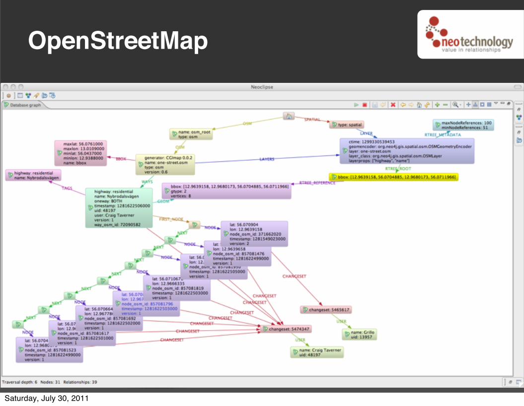
OpenStreetMap - Topology
13Saturday, July 30, 2011
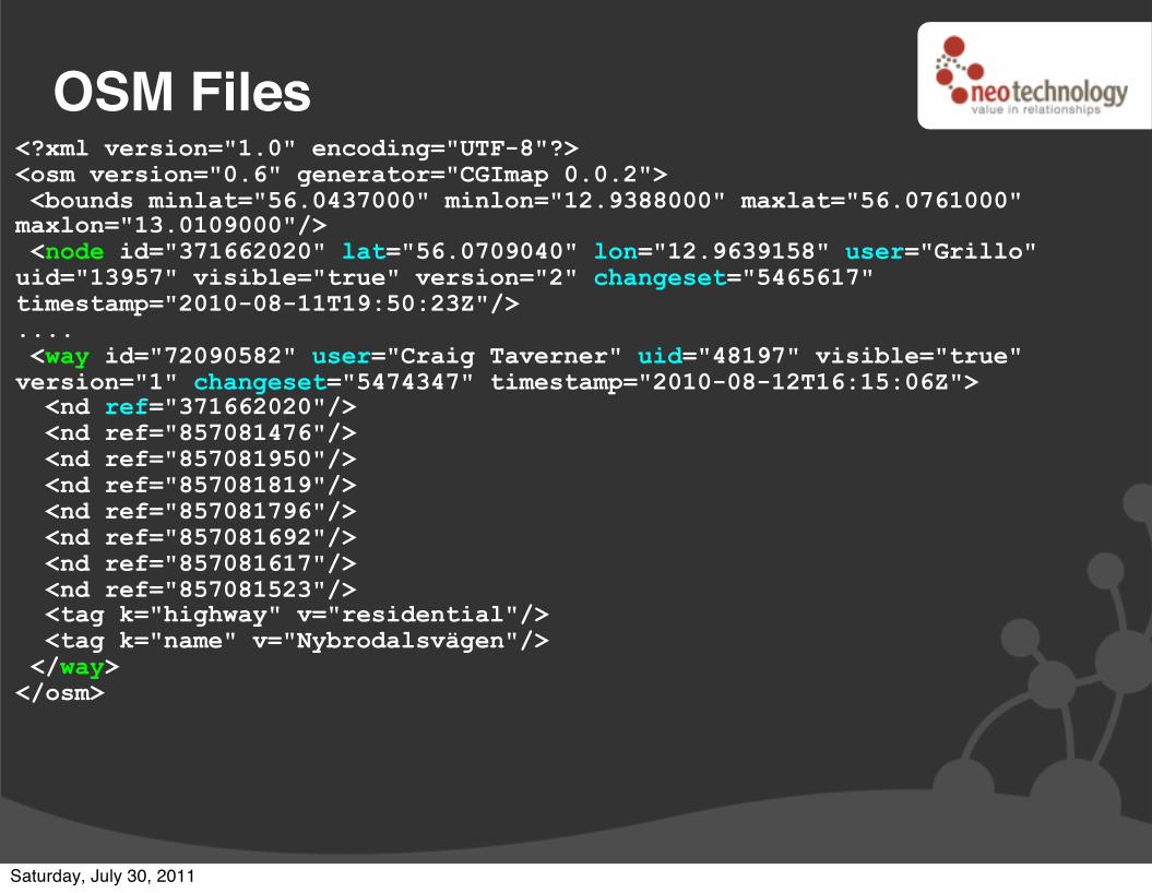
OSM Files<?xml version="1.0" encoding="UTF-8"?><osm version="0.6" generator="CGImap 0.0.2"> <bounds minlat="56.0437000" minlon="12.9388000" maxlat="56.0761000" maxlon="13.0109000"/> <node id="371662020" lat="56.0709040" lon="12.9639158" user="Grillo" uid="13957" visible="true" version="2" changeset="5465617" timestamp="2010-08-11T19:50:23Z"/>.... <way id="72090582" user="Craig Taverner" uid="48197" visible="true" version="1" changeset="5474347" timestamp="2010-08-12T16:15:06Z"> <nd ref="371662020"/> <nd ref="857081476"/> <nd ref="857081950"/> <nd ref="857081819"/> <nd ref="857081796"/> <nd ref="857081692"/> <nd ref="857081617"/> <nd ref="857081523"/> <tag k="highway" v="residential"/> <tag k="name" v="Nybrodalsvägen"/> </way></osm>
Saturday, July 30, 2011

OpenStreetMap
Saturday, July 30, 2011
OpenStreetMap
Saturday, July 30, 2011

OpenStreetMap
Saturday, July 30, 2011
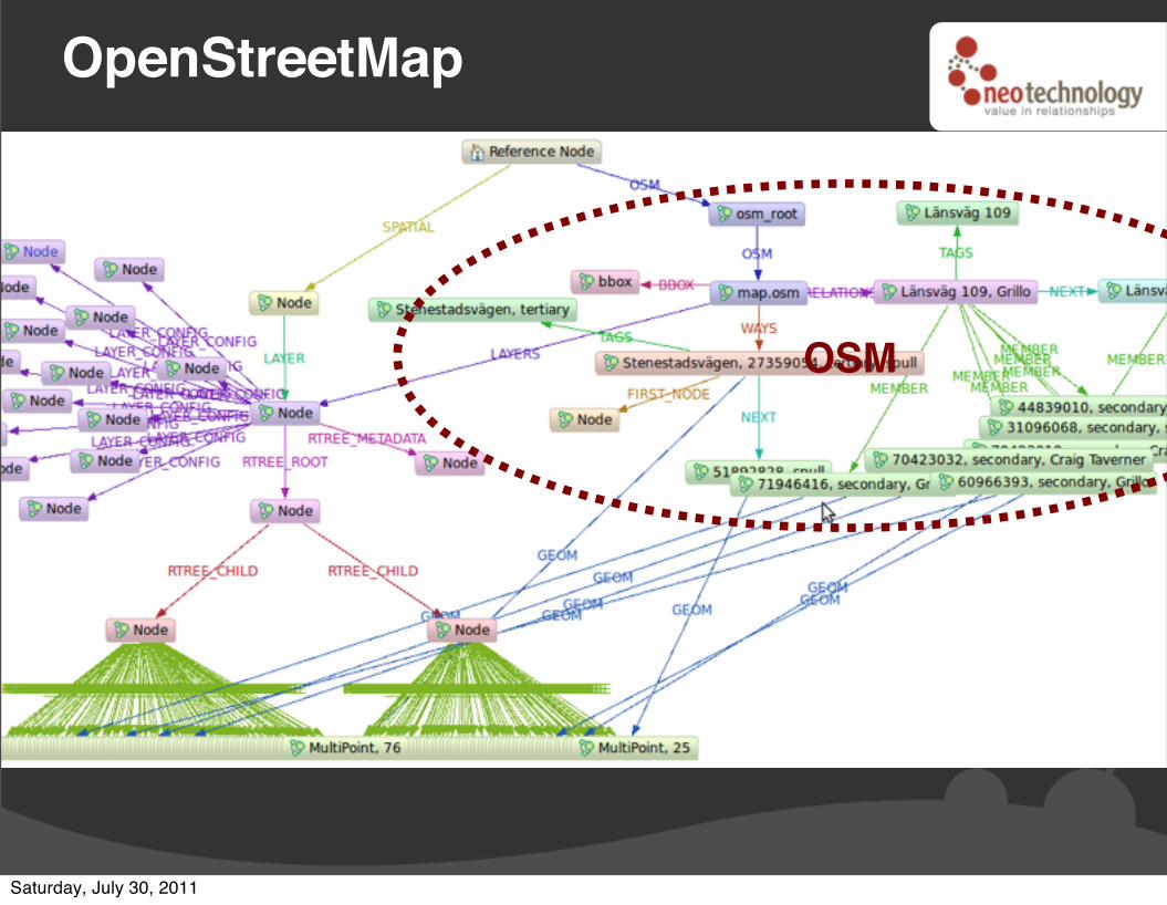
OpenStreetMap
OSM
Saturday, July 30, 2011

OpenStreetMap
OSMDynamicLayers
Saturday, July 30, 2011

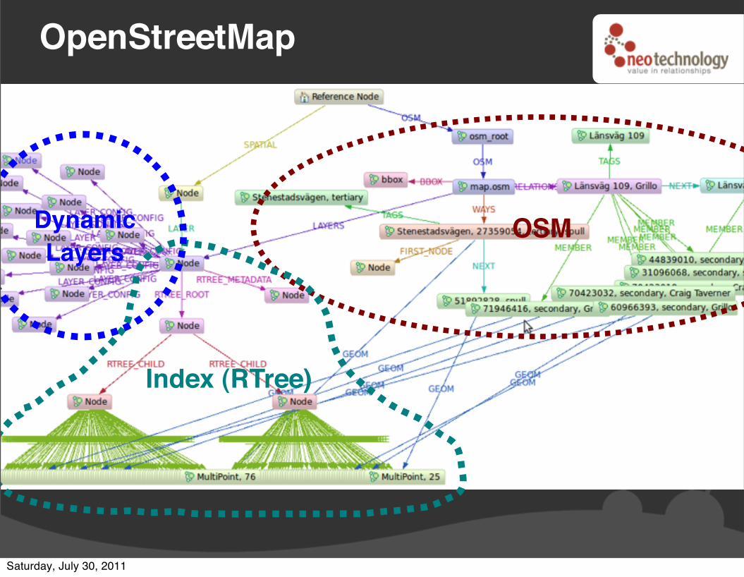
OpenStreetMap
OSM
Index (RTree)
DynamicLayers
Saturday, July 30, 2011
Layers
Saturday, July 30, 2011

From Graph to Layer
Saturday, July 30, 2011

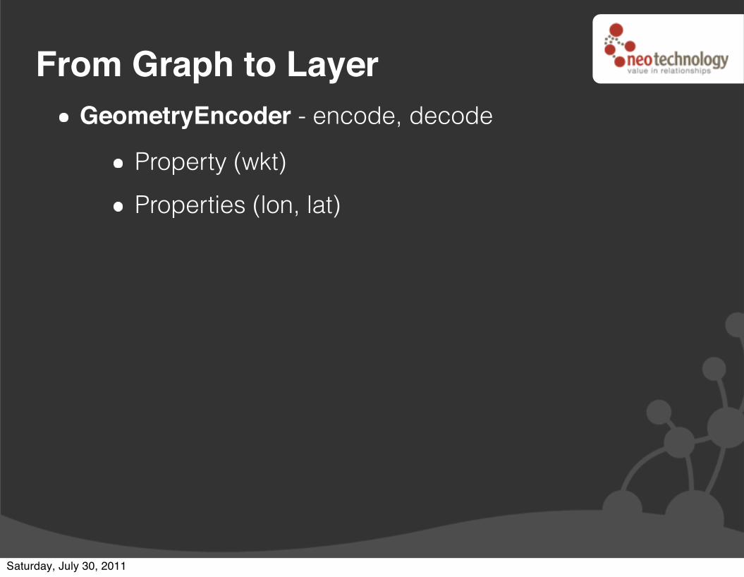
From Graph to LayerGeometryEncoder - encode, decode
Saturday, July 30, 2011

From Graph to LayerGeometryEncoder - encode, decode
Property (wkt)
Saturday, July 30, 2011
From Graph to LayerGeometryEncoder - encode, decode
Property (wkt)
Properties (lon, lat)
Saturday, July 30, 2011

From Graph to LayerGeometryEncoder - encode, decode
Property (wkt)
Properties (lon, lat)
Subgraph (ways, polygons)
Saturday, July 30, 2011

From Graph to LayerGeometryEncoder - encode, decode
Property (wkt)
Properties (lon, lat)
Subgraph (ways, polygons)
Domain specific (e.g. OSM)
Saturday, July 30, 2011

From Graph to LayerGeometryEncoder - encode, decode
Property (wkt)
Properties (lon, lat)
Subgraph (ways, polygons)
Domain specific (e.g. OSM)
OSM Way encoding/decoding
Saturday, July 30, 2011

From Graph to LayerGeometryEncoder - encode, decode
Property (wkt)
Properties (lon, lat)
Subgraph (ways, polygons)
Domain specific (e.g. OSM)
OSM Way encoding/decoding
CRS, Geometry type
Saturday, July 30, 2011

From Graph to LayerGeometryEncoder - encode, decode
Property (wkt)
Properties (lon, lat)
Subgraph (ways, polygons)
Domain specific (e.g. OSM)
OSM Way encoding/decoding
CRS, Geometry type
Styling
Saturday, July 30, 2011

From Graph to LayerGeometryEncoder - encode, decode
Property (wkt)
Properties (lon, lat)
Subgraph (ways, polygons)
Domain specific (e.g. OSM)
OSM Way encoding/decoding
CRS, Geometry type
Styling
Dynamic Layers
Saturday, July 30, 2011

From Graph to LayerGeometryEncoder - encode, decode
Property (wkt)
Properties (lon, lat)
Subgraph (ways, polygons)
Domain specific (e.g. OSM)
OSM Way encoding/decoding
CRS, Geometry type
Styling
Dynamic Layers
Search
Saturday, July 30, 2011

Dynamic Layers, uDig
Saturday, July 30, 2011

Dynamic Layers, GeoServer
Saturday, July 30, 2011

Indexes
Saturday, July 30, 2011

Multiple indexes - GIS
Illustrations: WikipediaSaturday, July 30, 2011

OpenStreetMap
Saturday, July 30, 2011
OpenStreetMap
OSM
Index (RTree)
DynamicLayers
Saturday, July 30, 2011

In - graph indexingIndex<Node> index = db.index().forNodes( "layer1");Node n1 = db.createNode();n1.setProperty( "lat", (double)56.2 );n1.setProperty( "lon", (double)15.3 );index.add( n1 );
Java:index.query( LayerNodeIndex.BBOX_QUERY, "[15.0, 16.0, 56.0, 57.0]" );
Cypher:START poi=(layer1,'bbox:[15.0, 16.0, 56.0, 57.0]') MATCH (poi) -[r] - (x) RETURN poi, r~TYPE, x.layer?
Gremlin:g.idx('node')[[layer1: 'bbox:[15.0, 16.0, 56.0, 57.0]']]
Saturday, July 30, 2011

Styling
Saturday, July 30, 2011
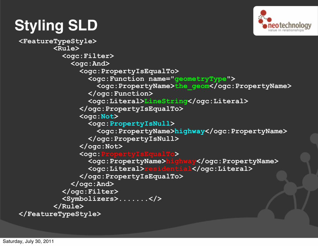
Styling SLD<FeatureTypeStyle> <Rule> <ogc:Filter> <ogc:And> <ogc:PropertyIsEqualTo> <ogc:Function name="geometryType"> <ogc:PropertyName>the_geom</ogc:PropertyName> </ogc:Function> <ogc:Literal>LineString</ogc:Literal> </ogc:PropertyIsEqualTo> <ogc:Not> <ogc:PropertyIsNull> <ogc:PropertyName>highway</ogc:PropertyName> </ogc:PropertyIsNull> </ogc:Not> <ogc:PropertyIsEqualTo> <ogc:PropertyName>highway</ogc:PropertyName> <ogc:Literal>residential</ogc:Literal> </ogc:PropertyIsEqualTo> </ogc:And> </ogc:Filter> <Symbolizers>.......</> </Rule></FeatureTypeStyle>
Saturday, July 30, 2011
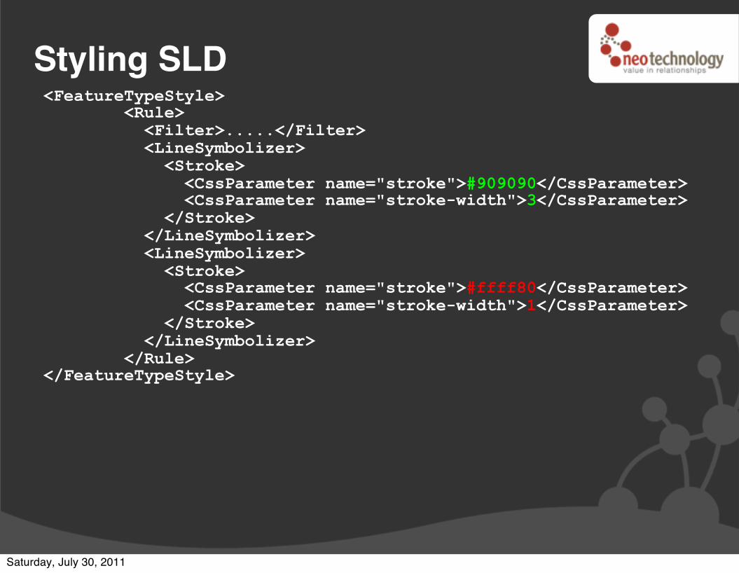
Styling SLD<FeatureTypeStyle> <Rule> <Filter>.....</Filter> <LineSymbolizer> <Stroke> <CssParameter name="stroke">#909090</CssParameter> <CssParameter name="stroke-width">3</CssParameter> </Stroke> </LineSymbolizer> <LineSymbolizer> <Stroke> <CssParameter name="stroke">#ffff80</CssParameter> <CssParameter name="stroke-width">1</CssParameter> </Stroke> </LineSymbolizer> </Rule></FeatureTypeStyle>
Saturday, July 30, 2011

Styling Ruby DSLrequire 'amanzi/sld'
Amanzi::SLD::Config.config[:geometry_property] = 'the_geom'#Amanzi::SLD::Config.config[:verbose] = true
sld = Amanzi::SLD::Document.new "Example Neo4j Spatial OSM Style"
sld.comment "A style for residential streets"sld. add_line_symbolizer(:stroke => '#909090', :stroke_width => 3). add_line_symbolizer(:stroke => '#ffff80', :stroke_width => 1) do |f| f.op(:and) do |f| f.geometry = 'LineString' f.property.exists? 'highway' f.property['highway'] = 'residential' endendsld
Saturday, July 30, 2011

Dynamic Layers, styling
Saturday, July 30, 2011

Dynamic Layers, styling
Saturday, July 30, 2011

Dynamic Layers, styling
Saturday, July 30, 2011
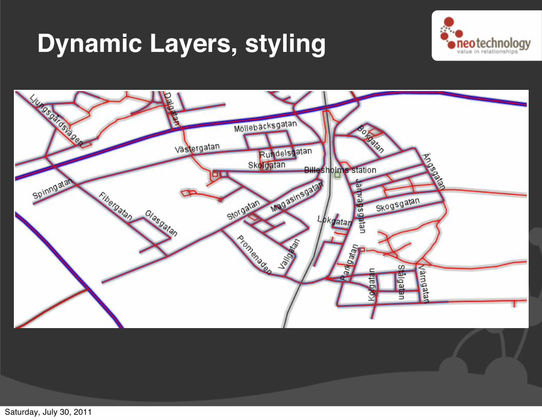
Dynamic Layers, styling
Saturday, July 30, 2011

Geoprocessing
Saturday, July 30, 2011

GSoC: PostGIS -> OSM Graph
33Saturday, July 30, 2011
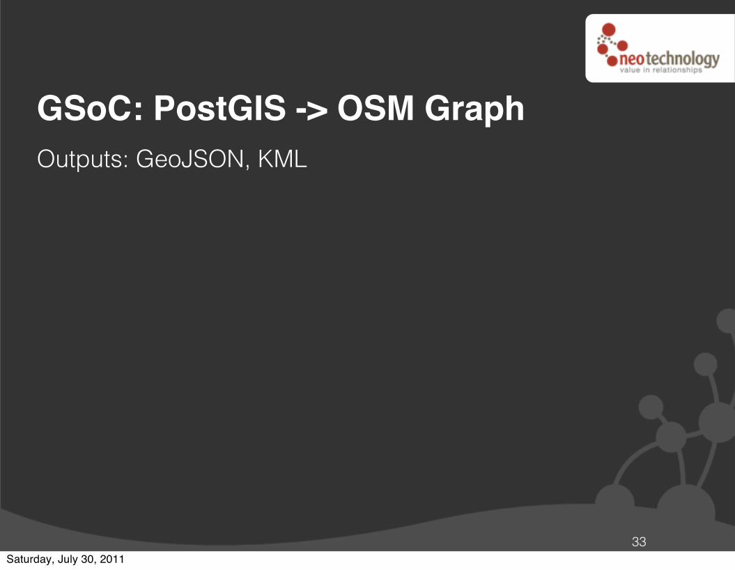
GSoC: PostGIS -> OSM GraphOutputs: GeoJSON, KML
33Saturday, July 30, 2011

GSoC: PostGIS -> OSM GraphOutputs: GeoJSON, KML
33Saturday, July 30, 2011

GSoC: PostGIS -> OSM GraphOutputs: GeoJSON, KML
Accessors: ST_EndPoint
33Saturday, July 30, 2011

GSoC: PostGIS -> OSM GraphOutputs: GeoJSON, KML
Accessors: ST_EndPoint
33Saturday, July 30, 2011

GSoC: PostGIS -> OSM GraphOutputs: GeoJSON, KML
Accessors: ST_EndPoint
Processing: ST_CLosest, ST_Disjoint
33Saturday, July 30, 2011

GSoC: PostGIS -> OSM GraphOutputs: GeoJSON, KML
Accessors: ST_EndPoint
Processing: ST_CLosest, ST_Disjoint
33Saturday, July 30, 2011

GSoC: PostGIS -> OSM GraphOutputs: GeoJSON, KML
Accessors: ST_EndPoint
Processing: ST_CLosest, ST_Disjoint
Search: SearchWithin, SearchClosest, Route, etc
33Saturday, July 30, 2011

GSoC: PostGIS -> OSM GraphOutputs: GeoJSON, KML
Accessors: ST_EndPoint
Processing: ST_CLosest, ST_Disjoint
Search: SearchWithin, SearchClosest, Route, etc
33Saturday, July 30, 2011

GSoC: PostGIS -> OSM GraphOutputs: GeoJSON, KML
Accessors: ST_EndPoint
Processing: ST_CLosest, ST_Disjoint
Search: SearchWithin, SearchClosest, Route, etc
Thanks Andreas Wilhelm!33
Saturday, July 30, 2011

Routing
Saturday, July 30, 2011

Routing
Saturday, July 30, 2011

Graph - Algos, A*
Saturday, July 30, 2011

h"p://www.transportdublin.ie/ -‐ Patrick Fitzgerald on Neo4jSaturday, July 30, 2011
Neo4j Spatial examples
Saturday, July 30, 2011

Polymap3
Saturday, July 30, 2011

AWE
Saturday, July 30, 2011

Cell network analysis
Saturday, July 30, 2011

Next steps
Saturday, July 30, 2011

Next stepsNeo4j Spatial
Saturday, July 30, 2011

Next stepsNeo4j Spatial
Cypher, Gremlin, CQL dynamic querying
Saturday, July 30, 2011

Next stepsNeo4j Spatial
Cypher, Gremlin, CQL dynamic querying
Graph Geoprocessing domain level - GSoC 2011
Saturday, July 30, 2011

Next stepsNeo4j Spatial
Cypher, Gremlin, CQL dynamic querying
Graph Geoprocessing domain level - GSoC 2011
Index Performance optimizations
Saturday, July 30, 2011

Next stepsNeo4j Spatial
Cypher, Gremlin, CQL dynamic querying
Graph Geoprocessing domain level - GSoC 2011
Index Performance optimizations
Pluggable indexing, Composite Index
Saturday, July 30, 2011

Next stepsNeo4j Spatial
Cypher, Gremlin, CQL dynamic querying
Graph Geoprocessing domain level - GSoC 2011
Index Performance optimizations
Pluggable indexing, Composite Index
Routing API support
Saturday, July 30, 2011

Next stepsNeo4j Spatial
Cypher, Gremlin, CQL dynamic querying
Graph Geoprocessing domain level - GSoC 2011
Index Performance optimizations
Pluggable indexing, Composite Index
Routing API support
OSM
Saturday, July 30, 2011

Next stepsNeo4j Spatial
Cypher, Gremlin, CQL dynamic querying
Graph Geoprocessing domain level - GSoC 2011
Index Performance optimizations
Pluggable indexing, Composite Index
Routing API support
OSM
uDig OSM Topology editor - GSoC 2011
Saturday, July 30, 2011
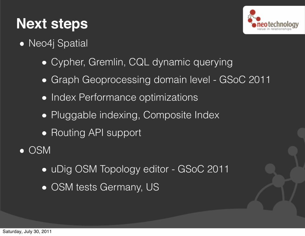
Next stepsNeo4j Spatial
Cypher, Gremlin, CQL dynamic querying
Graph Geoprocessing domain level - GSoC 2011
Index Performance optimizations
Pluggable indexing, Composite Index
Routing API support
OSM
uDig OSM Topology editor - GSoC 2011
OSM tests Germany, US
Saturday, July 30, 2011

Next stepsNeo4j Spatial
Cypher, Gremlin, CQL dynamic querying
Graph Geoprocessing domain level - GSoC 2011
Index Performance optimizations
Pluggable indexing, Composite Index
Routing API support
OSM
uDig OSM Topology editor - GSoC 2011
OSM tests Germany, US
Stitching for OSM datasets
Saturday, July 30, 2011

Get involved!
http://github.com/neo4j/neo4j-spatial
http://neo4j.org
Saturday, July 30, 2011

http://neotechnology.com44
And - we are hiring!
Saturday, July 30, 2011