neotectonic and volcanic characteristics of the karasu...
TRANSCRIPT

Neotectonic and volcanic characteristicsof the Karasu fault zone (Anatolia, Turkey):
The transition zone between the Dead Sea transformand the East Anatolian fault zone
Bora Rojaya*, Ariel Heimannb, Vedat Topraka
a Department of Geological Engineering, Middle East Technical University, 06531 Ankara, Turkeyb Geological Survey of Israel, 30 Malkhe Israel St., Jerusalem, 95501, Israel
Received 2 January 2000; accepted 21 May 2000
Abstract – The Karasu Rift (Antakya province, SE Turkey) hasdeveloped between east-dipping, NNE-striking faults of the Karasufault zone, which define the western margin of the rift and west-dipping, N–S to N20–30E-striking faults of Dead Sea Transformfault zone (DST) in the central part and eastern margin of the rift.The strand of the Karasu fault zone that bounds the basin from westforms a linkage zone between DST and East Anatolian fault zone(EAFZ). The greater vertical offset on the western margin faultsrelative to the eastern ones indicates asymmetrical evolution of therift as implied by the higher escarpments and accumulation of exten-sive, thick alluvial fans on the western margins of the rift. The thick-ness of the Quaternary sedimentary fill is more than 465 m, withclastic sediments intercalated with basaltic lavas. The Quaternaryalkali basaltic volcanism accompanied fluvial to lacustrine sedi-mentation between 1.57± 0.08 and 0.05± 0.03 Ma. The faults areleft-lateral oblique-slip faults as indicated by left-stepping faultingpatterns, slip-lineation data and left-laterally offset lava flows andstream channels along the Karasu fault zone. At Hacılar village, anoffset lava flow, dated to 0.08± 0.06 Ma, indicates a rate of left-lateral oblique slip of approximately 4.1 mm·year–1. Overall, theKarasu Rift is an asymmetrical transtensional basin, which hasdeveloped between seismically active splays of the left-lateral DSTand the left-lateral oblique-slip Karasu fault zone during the neo-tectonic period. © 2001 Éditions scientifiques et médicales ElsevierSAS
continental alkali basaltic volcanism / Karasu fault zone /Karasu Rift / Dead Sea transform fault / Anatolia / Turkey
1. Introduction
The relative motion between theArabian,African and Eur-asian plates is the key for the geodynamics of the EasternMediterranean region. The motion of the African and Ara-bian plates towards the Eurasian Plate has caused conver-gence in the Eastern Mediterranean region since the LateCretaceous (figure 1) [1–5].
As a result of this collision between the Arabian and theEurasian plates, the Anatolian block has migrated westwardtowards the Eastern Mediterranean Ridge on the AfricanPlate (figure 1). This lateral extrusion of the Anatolian blockis accommodated by two major continental transform faults:– the North Anatolian fault zone (NAFZ) and the East Ana-tolian fault zone (EAFZ) [e.g., 1, 5–8].
The EAFZ and the Dead Sea transform fault zone (DST)meet at a triple junction between the Arabian Plate, the Afri-can Plate and the Anatolian Block. The nature of slip on theDST, the bounding fault between the Arabian and Africanplates [e.g. 9, 10], and the EAFZ, are individually wellresolved, based on field, geophysical and kinematic data.However, the nature and geometry at their continuations asthey approach the triple junction are still discussed.
The DST is a dominantly left-lateral transform fault, withan extensional component, that forms various rift depres-sions [11–14]. It is more than 1 000 km long, links the RedSea, where oceanic spreading takes place, to the Taurus zoneof plate collision (figure 1). It became active in MiddleMiocene time and it is still seismically active [e.g., 14].
*Correspondence and reprints.E-mail address:[email protected] (B. Rojay).
Geodinamica Acta 14 (2001) 1–17© 2001 Éditions scientifiques et médicales Elsevier SAS. All rights reserved
S0985311100010536/FLA
— 1 —

An maximum offset of 105–107 km was measured in thesection connecting Mt. Hermon in Lebanon (Yammunnehfault) and the Gulf of Aqaba [e.g. 12, 15]. Lateral offset ofthe DST to the north of the Yammunneh fault is much lessconstrained. A 70–80 km of displacement was suggested bydisplaced Upper Cretaceous ophiolites in northern Syria andsoutheastern Turkey where the attitudes of ophiolitic unitsare unknown to northern tip of DST [16]. However, only10–20 km of total slip was also suggested for that section[e.g., 17].
The EAFZ has an average trend of N66°E and displays aleft-lateral strike-slip character with various restrainingbends. It is located between Karliova (eastern Anatolia)where it joins the NAFZ and Türkog˘lu (south of Maras¸) [1,8, 18–23]. The measured slip on the EAFZ is about 3.5–13km on displaced Euphrates River channels and 15–27 km
on displaced pre-Pliocene units [4, 18, 19, 22]. Howeverthese estimates of the displacement on the EAFZ are muchtoo low according to Westaway and Arger (1996) [24] whopropose an offset of 35–40 km.
In addition to geological and kinematic estimates for thedisplacements, fault plane solutions of earthquakes clearlyshow dextral slip sense along the NAFZ and sinistral slipsenses along the EAFZ and DST [25, 26]. It is evident thatthe region is seismically active.
A comprehensive slip lineation analyses of fault surfacesconcluded that two phases of deformation occurred in thearea; an older N–S directed compressional phase and a morerecent E–W extensional phase [27, 28].
The direct relations between the DST and the EAFZ are amatter of debate due to lack of data from this tectonically
Figure 1. Major neotectonic elements of Eastern Mediterranean. Arrows show direction of plate motions. (Simplified and modified from[48–51]).
B. Rojay et al. / Geodinamica Acta 14 (2001) 1–17
— 2 —
complicated area (S of Maras¸). Various views are proposed;a) the EAFZ continues in southwestern trend from Karliovato north of Cyprus and is not directly connected to the DST[4, 24, 27, 29]; b) The Türkog˘lu–Amik segment (Karasu faultzone) is interpreted as a separate fault [28–31], c) the EAFZcontinues until Samandag˘ (Mediterranean Sea) in splay orleft-stepping pattern [8, 22, 23, 27, 29, 32], and finally, d)the EAFZ interpreted as a northward continuation of the DST[18, 20].
The Karasu Rift is located within the EAFZ and the DST.Any interpretation, as discussed above, can relate the for-mation of this rift to the DST, to the EAFZ, to a combina-tion of them, or as a transition zone between them. The rifthas been interpreted as a pull-apart basin [30, 32, 33], as ahalf-graben caused by a flexural bend [23], as a graben result-ing from divergent strike-slip motion [20, 29, 32, 34], as agraben resulting from the westward escape of the AnatolianPlate [28].
The Maras¸–Antakya–I˙skenderun region is located withina seismically active region with significant activity since his-torical times [35]. Most of the largest known historic earth-quakes occurred in the Antakya region [35]. The most recentearthquake (January 22, 1997, with M = 5.5; [36]) occurredto the west of Antakya. It is thus evident that the rift is seis-mically active. This earthquake’s fault plane solution indi-cates a NE–SW left-lateral fault plane with a normal dip-slip component [36].
The aim of this paper is to shed some light onto the neo-tectonic evolution of the Karasu Rift based on K-Ar datingof its volcanism, age and type of faulting during the Plio-Quaternary period.
2. Geological setting of the Karasu Rift
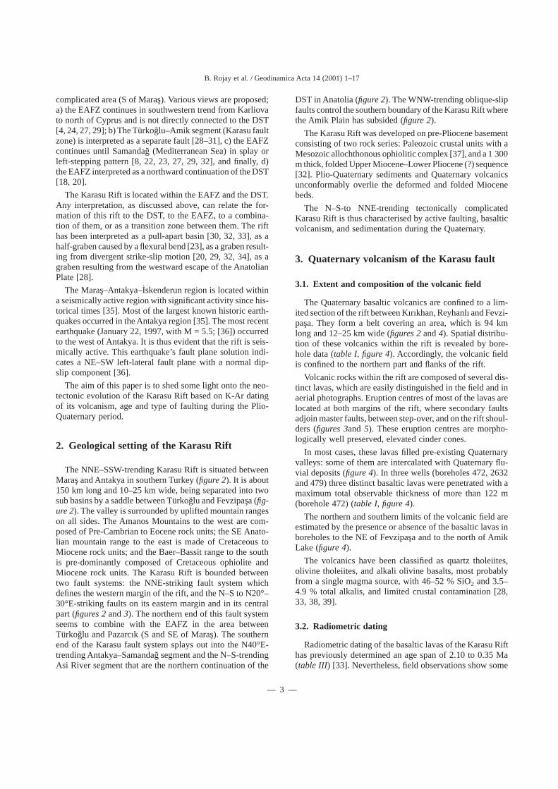
The NNE–SSW-trending Karasu Rift is situated betweenMarasand Antakya in southern Turkey (figure 2). It is about150 km long and 10–25 km wide, being separated into twosub basins by a saddle between Türkog˘lu and Fevzipas¸a (fig-ure 2). The valley is surrounded by uplifted mountain rangeson all sides. The Amanos Mountains to the west are com-posed of Pre-Cambrian to Eocene rock units; the SE Anato-lian mountain range to the east is made of Cretaceous toMiocene rock units; and the Baer–Bassit range to the southis pre-dominantly composed of Cretaceous ophiolite andMiocene rock units. The Karasu Rift is bounded betweentwo fault systems: the NNE-striking fault system whichdefines the western margin of the rift, and the N–S to N20°–30°E-striking faults on its eastern margin and in its centralpart (figures 2and3). The northern end of this fault systemseems to combine with the EAFZ in the area betweenTürkoglu and Pazarcık (S and SE of Maras¸). The southernend of the Karasu fault system splays out into the N40°E-trending Antakya–Samandag˘ segment and the N–S-trendingAsi River segment that are the northern continuation of the
DST in Anatolia (figure 2). The WNW-trending oblique-slipfaults control the southern boundary of the Karasu Rift wherethe Amik Plain has subsided (figure 2).
The Karasu Rift was developed on pre-Pliocene basementconsisting of two rock series: Paleozoic crustal units with aMesozoic allochthonous ophiolitic complex [37], and a 1 300m thick, folded Upper Miocene–Lower Pliocene (?) sequence[32]. Plio-Quaternary sediments and Quaternary volcanicsunconformably overlie the deformed and folded Miocenebeds.
The N–S-to NNE-trending tectonically complicatedKarasu Rift is thus characterised by active faulting, basalticvolcanism, and sedimentation during the Quaternary.
3. Quaternary volcanism of the Karasu fault
3.1. Extent and composition of the volcanic field
The Quaternary basaltic volcanics are confined to a lim-ited section of the rift between Kırıkhan, Reyhanlı and Fevzi-pasa. They form a belt covering an area, which is 94 kmlong and 12–25 km wide (figures 2and4). Spatial distribu-tion of these volcanics within the rift is revealed by bore-hole data (table I, figure 4). Accordingly, the volcanic fieldis confined to the northern part and flanks of the rift.
Volcanic rocks within the rift are composed of several dis-tinct lavas, which are easily distinguished in the field and inaerial photographs. Eruption centres of most of the lavas arelocated at both margins of the rift, where secondary faultsadjoin master faults, between step-over, and on the rift shoul-ders (figures 3and 5). These eruption centres are morpho-logically well preserved, elevated cinder cones.
In most cases, these lavas filled pre-existing Quaternaryvalleys: some of them are intercalated with Quaternary flu-vial deposits (figure 4). In three wells (boreholes 472, 2632and 479) three distinct basaltic lavas were penetrated with amaximum total observable thickness of more than 122 m(borehole 472) (table I, figure 4).
The northern and southern limits of the volcanic field areestimated by the presence or absence of the basaltic lavas inboreholes to the NE of Fevzipas¸a and to the north of AmikLake (figure 4).
The volcanics have been classified as quartz tholeiites,olivine tholeiites, and alkali olivine basalts, most probablyfrom a single magma source, with 46–52 % SiO2 and 3.5–4.9 % total alkalis, and limited crustal contamination [28,33, 38, 39].
3.2. Radiometric dating
Radiometric dating of the basaltic lavas of the Karasu Rifthas previously determined an age span of 2.10 to 0.35 Ma(table III) [33]. Nevertheless, field observations show some
B. Rojay et al. / Geodinamica Acta 14 (2001) 1–17
— 3 —
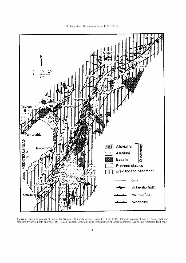
Figure 2. Regional geological map of the Karasu Rift and its vicinity (simplified from 1:500 000 scale geological map of Turkey [52] andmodified by aerial photo analysis). DST: Dead Sea transform fault zone (continuation of Gharb segment), EAFZ: East Anatolian fault zone.
B. Rojay et al. / Geodinamica Acta 14 (2001) 1–17
— 4 —
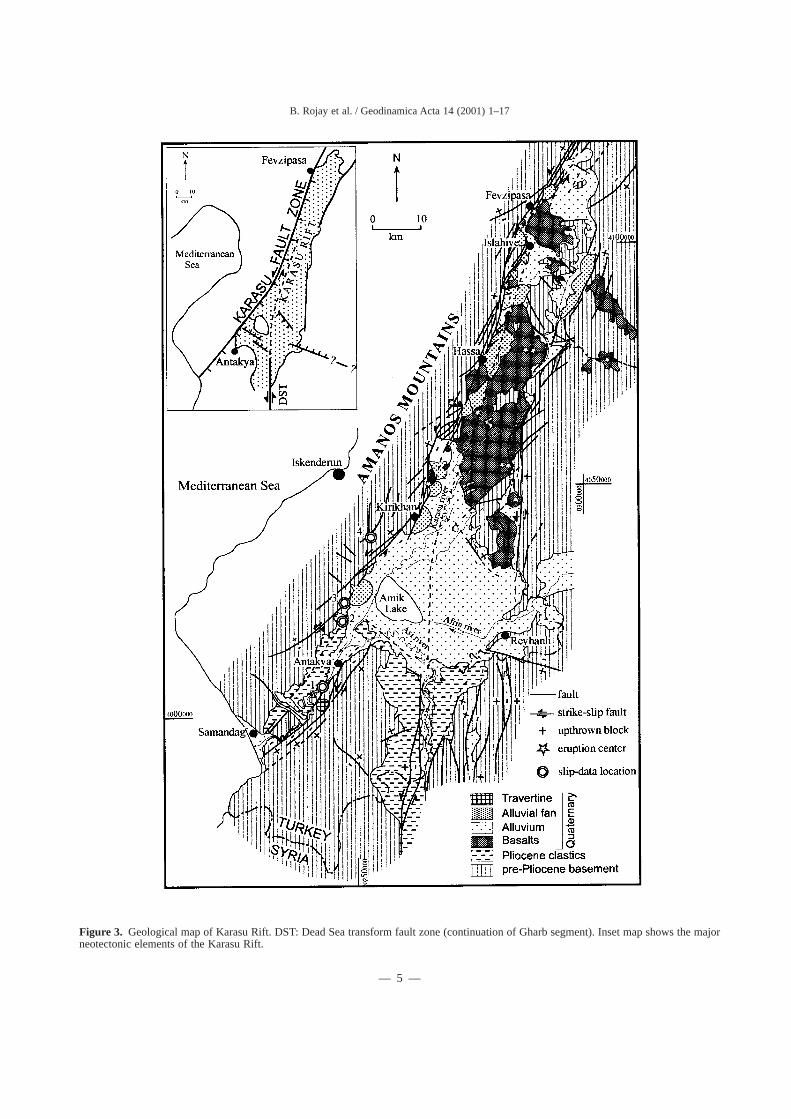
Figure 3. Geological map of Karasu Rift. DST: Dead Sea transform fault zone (continuation of Gharb segment). Inset map shows the majorneotectonic elements of the Karasu Rift.
B. Rojay et al. / Geodinamica Acta 14 (2001) 1–17
— 5 —
Figure 4. Borehole data from Karasu Rift. Number on top of sections refers to borehole number; number at side of the section refers to thedepth (table I). Note that the stratigraphy is simplified in the sections into three units as: pre-Pliocene basement rocks, Quaternary sedimentaryunits and Quaternary basaltic rocks intercalated with sediments (Borehole data are from [42])
B. Rojay et al. / Geodinamica Acta 14 (2001) 1–17
— 6 —

different stratigraphic relations with previous age determi-nations, which suggest that at least some of the lavas arevery young. This is true for several lavas, especially for theflow unit located south of Körog˘lu, which was dated as 2.10Ma by Çapan et al [33]. The freshness and the morphologyof the lavas as well as their stratigraphic relations with Qua-ternary sediments suggest that they are of Quaternary age.Therefore, re-sampling and dating of the volcanic field werecarried out in the same field (figure 5).
Unfortunately, two other volcanic centres (on the Syrianborder,figure 5) could not be sampled and dated.
3.3. K-Ar Method
A short description of the experimental procedures usedis as follows [40, 41]. Samples of approximately 1 kg werecollected from each site. Special care was taken in choosingfresh samples. Only samples which showed none (to very
minimum) alteration were dated. Each sample was crushedand sieved (70-90 mesh) and washed with water, alcohol,and acetone 0.5 M HCl was used for leaching the samplesfor one hour. Final cleaning of the samples was carried outby magnetic separation. Potassium was measured by atomicabsorption and40Ar by isotope dilution. Ar was analysed ona VG MM-1200B mass spectrometer at the Geological Sur-vey of Israel Geochronological laboratory.
3.4. Results on Quaternary volcanism
The results of the analysis are given intable II andIII andwill be discussed according to its geographical distributionfrom south to north.
Two lavas in the vicinity of Ceylanlı were dated to0.66± 0.04 and 1.57± 0.08 Ma (Sites 1, 2 respectively,tableII , figure 5). These lavas are part of a relatively old volcanicactivity in the area. The 1.57 Ma lava is faulted by one of
Table I. Borehole data for Karasu Rift (DSI˙ [42]).
Well UTM-X Coor. UTM-Y Coor. Elevation (m) Total Depth ( m)(1) Frequency of lavas(2)
Thickness of lavas(m) (3)
471 284470 4081490 392.5 140 1 9472 272580 4056490 130.00 137 3 121473 268630 4051760 109.14 35 1 11474 271810 4046975 87.48 151 2 109475 265300 4044410 97.17 190476 262470 4038670 85.65 250477 255840 4032860 90.00 362478 250955 4022180 87.36 356479 263530 4031755 83.74 363 3 56480 252880 4028270 87.59 309481 255350 4022790 79.89 3001273 265940 4016620 85.19 1002630 257025 4022025 81.67 3602631 267960 4035940 82.10 356 2 592632 273730 4030075 86.34 350 3 632636 280470 4024650 94.66 250 2 302798 272425 4023340 86.40 3562928 272290 4039810 84.00 93 1 622929 263175 4012755 89.00 3502931 286640 4020550 125.37 3183122 248840 4018420 90.00 2838226 257240 4036465 104.58 2238241 282590 4013310 183.50 23810052 275425 4017125 950.00 16011169 259890 4038675 100.00 21011174 273970 4028305 89.00 29011294 300124 4108050 484 5014332 301650 4113625 477.50 24714334 298925 4106670 482.05 202 2 4114335 281575 4074610 342.5 225 1 1015198 289550 4094050 447.5 195
(1) Thickness of the borehole(2) Number of individual lava flows interfingered with clastic layers(3) Total thickness of all lava flows
B. Rojay et al. / Geodinamica Acta 14 (2001) 1–17
— 7 —
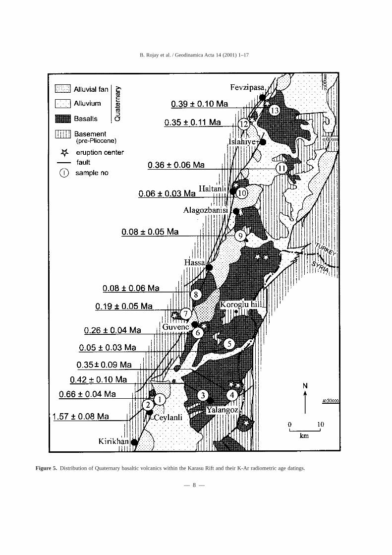
Figure 5. Distribution of Quaternary basaltic volcanics within the Karasu Rift and their K-Ar radiometric age datings.
B. Rojay et al. / Geodinamica Acta 14 (2001) 1–17
— 8 —
the marginal faults and therefore it seems that the valley atthe time of the eruption did not have its present configura-tion. On the other hand, the 0.66 Ma sample comes from avolcano (Küçük Höyük), located inside the valley close tomargins. Therefore, it seems that it was erupted at a timewhen the valley was already close to its present configura-tion. The absence of lava in borehole 475 suggests that theselavas do not have southern continuation beneath the allu-vium (table I, figure 4).
Site 3 and 4 are from lavas located near Yalangöz andnear the eastern margins of the valley (east of Yalangöz).These lavas, dated as 0.42± 0.10 Ma and 0.35± 0.09 respec-tively, come from one of the two eruption centres that arelocated close to the Turkish–Syrian border (figure 5). Nearbyboreholes (no. 474, 2928, 2631) contain lavas alternatingwith subsurface Quaternary sediments (table I, figure 4).
Site 5, near Körog˘lu hill (figure 5), is located in the south-ern part of the most widespread volcanic field of the area.Two eruption centres are located at the northern part of thisfield, close to the Turkish–Syrian border. This volcanic fieldand especially the dated lava, have a very fresh morphologi-cal appearance thus suggesting a young age. The radiomet-ric dating yields an age of 0.05± 0.03 Ma that confirms thefield data.
Site 6, dated to 0.26± 0.04 Ma, belongs to a volcanic unithaving an eruption centre east of Güvenç (Aktepe) (figure5). Field relations show that this lava is overlain by the lavaof site 4, so the radiometric dating is concordant with thestratigraphy. Three lavas, with a thickness of 121 m, weredrilled in borehole 472 and had a similar thickness at bore-
hole 474. These two boreholes suggest an earlier volcanicfield at the centre of the Karasu Rift.
Sites 7 (NW of Güvenç) and 8 (Hacılar, south of Hassa)are parts of lavas erupted from volcanic vents situated withina pre-existing Quaternary valley on the western margin ofthe rift (figure 5). The lavas, dated as 0.19± 0.05 and0.08± 0.06 Ma respectively, flowed through the pre-existingstream valleys into the Karasu Rift. The front of both lavaswas later faulted by the marginal faults. Hence, these faultshave been active since 0.08 Ma.
Sites 9 (SE of Alagözbanısı) and 10 (NE of Haltanlı) weredated as 0.08± 0.05 and 0.06± 0.03 Ma, respectively. Pet-rographically both lavas were found to be very similar byour unpublished geochemical analyses as well as Çapan etal [33]. This and the age similarity suggest that the source ofboth lavas might be the same volcanic centre, which is prob-ably located near Haltanlı along the western margin of thevalley (figure 5). An alluvial fan now separates this volcanicfield into two distinct parts.
Samples 11, 12 and 13 were collected from three separatevolcanic fields in the Fevzipas¸a–Islahiye area (figure 5). Theywere dated as 0.36± 0.06, 0.35± 0.11 and 0.39± 0.10 Ma,respectively. The field appearance as well as their age andpetrographic similarity suggest that they were actually fromthe same volcanic field. The volcanic field extends a fewkilometres to the north as it is evidenced by the presence oftwo lavas in borehole 14334 and by their absence in bore-holes 14332 and 11294 (table I, figure 4). On the other hand,it seems that the volcanic fields, on which sites 10 (Haltanlı)and 11, 12, 13 (Fevzipas¸a–Islahiye) were situated, are not
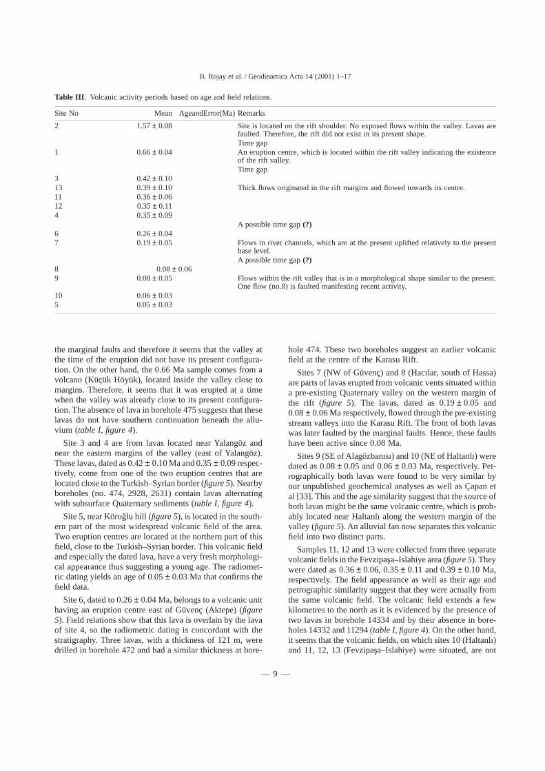
Table III . Volcanic activity periods based on age and field relations.
Site No Mean AgeandError(Ma) Remarks
2 1.57± 0.08 Site is located on the rift shoulder. No exposed flows within the valley. Lavas arefaulted. Therefore, the rift did not exist in its present shape.Time gap
1 0.66± 0.04 An eruption centre, which is located within the rift valley indicating the existenceof the rift valley.Time gap
3 0.42± 0.1013 0.39± 0.10 Thick flows originated in the rift margins and flowed towards its centre.11 0.36± 0.0612 0.35± 0.114 0.35± 0.09
A possible time gap(?)6 0.26± 0.047 0.19± 0.05 Flows in river channels, which are at the present uplifted relatively to the present
base level.A possible time gap(?)
8 0.08± 0.069 0.08± 0.05 Flows within the rift valley that is in a morphological shape similar to the present.
One flow (no.8) is faulted manifesting recent activity.10 0.06± 0.035 0.05± 0.03
B. Rojay et al. / Geodinamica Acta 14 (2001) 1–17
— 9 —
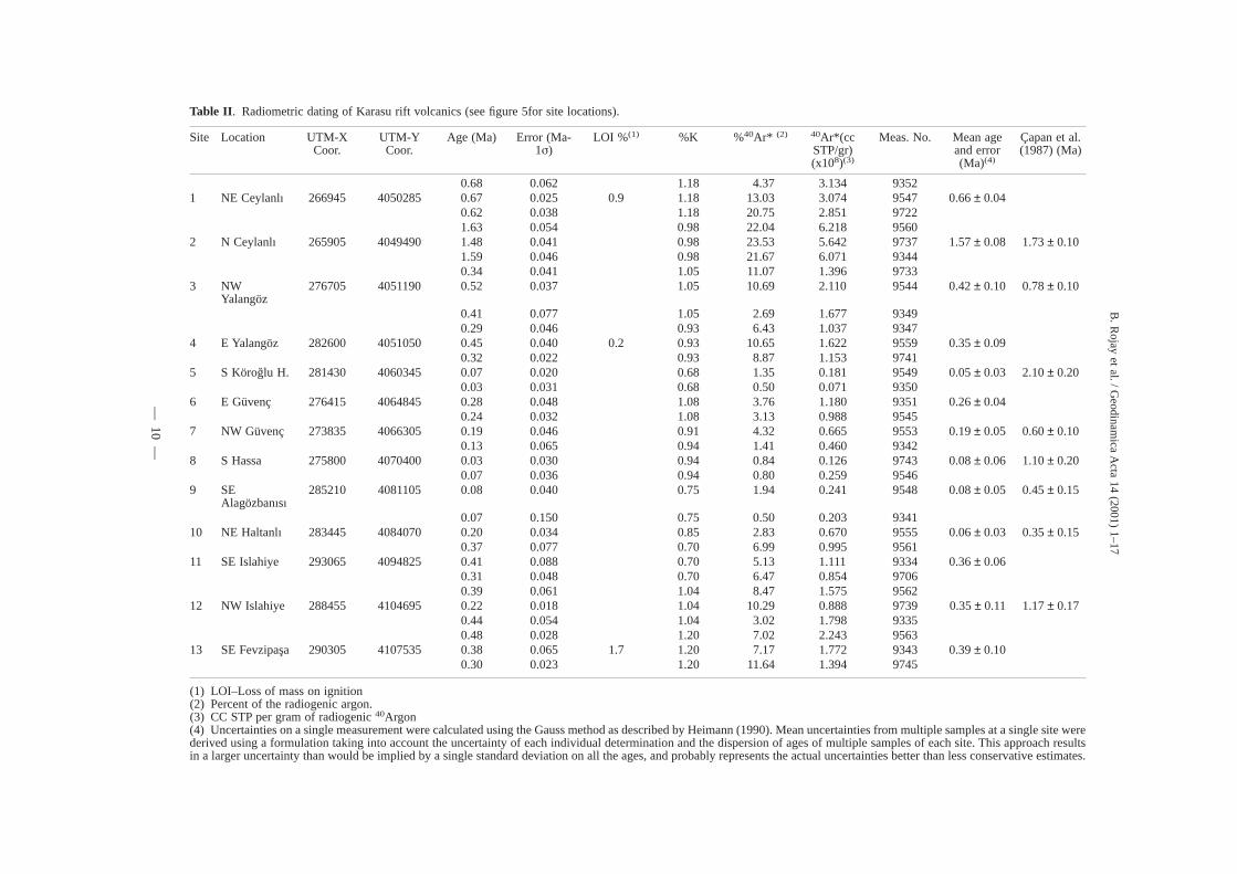
Table II . Radiometric dating of Karasu rift volcanics (see figure 5for site locations).
Site Location UTM-XCoor.
UTM-YCoor.
Age (Ma) Error (Ma-1σ)
LOI %(1) %K %40Ar* (2) 40Ar*(ccSTP/gr)(x108)(3)
Meas. No. Mean ageand error(Ma)(4)
Çapan et al.(1987) (Ma)
0.68 0.062 1.18 4.37 3.134 93521 NE Ceylanlı 266945 4050285 0.67 0.025 0.9 1.18 13.03 3.074 9547 0.66± 0.04
0.62 0.038 1.18 20.75 2.851 97221.63 0.054 0.98 22.04 6.218 9560
2 N Ceylanlı 265905 4049490 1.48 0.041 0.98 23.53 5.642 9737 1.57± 0.08 1.73± 0.101.59 0.046 0.98 21.67 6.071 93440.34 0.041 1.05 11.07 1.396 9733
3 NWYalangöz
276705 4051190 0.52 0.037 1.05 10.69 2.110 9544 0.42± 0.10 0.78± 0.10
0.41 0.077 1.05 2.69 1.677 93490.29 0.046 0.93 6.43 1.037 9347
4 E Yalangöz 282600 4051050 0.45 0.040 0.2 0.93 10.65 1.622 9559 0.35± 0.090.32 0.022 0.93 8.87 1.153 9741
5 S Köroglu H. 281430 4060345 0.07 0.020 0.68 1.35 0.181 9549 0.05± 0.03 2.10± 0.200.03 0.031 0.68 0.50 0.071 9350
6 E Güvenç 276415 4064845 0.28 0.048 1.08 3.76 1.180 9351 0.26± 0.040.24 0.032 1.08 3.13 0.988 9545
7 NW Güvenç 273835 4066305 0.19 0.046 0.91 4.32 0.665 9553 0.19± 0.05 0.60± 0.100.13 0.065 0.94 1.41 0.460 9342
8 S Hassa 275800 4070400 0.03 0.030 0.94 0.84 0.126 9743 0.08± 0.06 1.10± 0.200.07 0.036 0.94 0.80 0.259 9546
9 SEAlagözbanısı
285210 4081105 0.08 0.040 0.75 1.94 0.241 9548 0.08± 0.05 0.45± 0.15
0.07 0.150 0.75 0.50 0.203 934110 NE Haltanlı 283445 4084070 0.20 0.034 0.85 2.83 0.670 9555 0.06± 0.03 0.35± 0.15
0.37 0.077 0.70 6.99 0.995 956111 SE Islahiye 293065 4094825 0.41 0.088 0.70 5.13 1.111 9334 0.36± 0.06
0.31 0.048 0.70 6.47 0.854 97060.39 0.061 1.04 8.47 1.575 9562
12 NW Islahiye 288455 4104695 0.22 0.018 1.04 10.29 0.888 9739 0.35± 0.11 1.17± 0.170.44 0.054 1.04 3.02 1.798 93350.48 0.028 1.20 7.02 2.243 9563
13 SE Fevzipas¸a 290305 4107535 0.38 0.065 1.7 1.20 7.17 1.772 9343 0.39± 0.100.30 0.023 1.20 11.64 1.394 9745
(1) LOI–Loss of mass on ignition(2) Percent of the radiogenic argon.(3) CC STP per gram of radiogenic40Argon(4) Uncertainties on a single measurement were calculated using the Gauss method as described by Heimann (1990). Mean uncertainties from multiple samples at a single site werederived using a formulation taking into account the uncertainty of each individual determination and the dispersion of ages of multiple samples of each site. This approach resultsin a larger uncertainty than would be implied by a single standard deviation on all the ages, and probably represents the actual uncertainties better than less conservative estimates.
B.
Rojay
etal./G
eodinamica
Acta
14(2001)
1–17
—10
—
connected to each other as no lavas were indicated in bore-hole 15198. This is also supported by the significant age dif-ferences (0.36 vs. 0.07 Ma).
To summarize: the Quaternary volcanic field of the KarasuRift is located between Fevzipas¸a and the north of Reyhanlı,which are the north and northeastern parts of the valley. TheQuaternary basaltic volcanism was dated in this study to 1.6to 0.05 Ma which is much younger than the ages (2.10 to0.35 Ma) previously proposed by Çapan et al [33].
The lavas are differentiated into five groups consideringtheir ages and the field relations (table III). There are twoclear time gaps within the Quaternary volcanic activitybetween 1.57± 0.08 Ma and 0.66± 0.04 Ma, and between0.66± 0.04 Ma and 0.42± 0.10 Ma. Other two possible timegaps can also be present between 0.35± 0.11 Ma and0.26± 0.04 Ma, and between 0.19± 0.05 Ma and 0.08± 0.06Ma. The age relations indicate intermittent volcanism withinthe Karasu Rift.
4. Quaternary basin fill
The Plio-Quaternary Karasu valley is filled with fluvialand lacustrine sediments interfingered and covered with thevolcanic sequence (figure 3).Although these two rock groupsare intercalated in some parts of the area, in general, theyare observed in different parts of the rift. Recent alluvium,alluvial fans, talus, and lake deposits dissect the Plio-Quaternary sediments. Accumulations of travertine andcaliche-like deposits are present inAntakya and north of Kır-ıkhan along the western margin of the valley.
The nature and the thickness of sedimentary fill vary fromthe margins to the centre of the valley. Along the margins,alluvial fans and talus deposits, which are composed ofcoarse-grained clastics, reach 220 m thickness, unconform-ably overlying basement rocks. On the other hand, the basi-nal units are pre-dominantly light coloured clayey clasticsof up to 465 m thickness, with minor lenses of conglomer-ate.
Distribution of the sedimentary fill in the rift was inves-tigated using borehole data provided from State HydraulicWorks (Devlet Su I˙sleri, DSI) [42] (table I, figure 4).
The sedimentary facies and thickness of the sequence var-ies locally in different parts of the valley. The sediment fillhas a considerable thickness in the area between Fevzipas¸aand the Amik Lake, particularly along the western marginsof the valley. The maximum observable thickness on thewestern margin of the valley is more than 362 m (borehole477,figure 4). This borehole was drilled through coarse clas-tic sediments but did not reach the basement.
Within the Amik Plain the deposits gradually thickensfrom the margins towards the centre. The maximum thick-ness of the Quaternary fill is more than 350 m according toDSIwells (table I, boreholes 2929,479) and more than 465 m
according to TPAO (Turkish Petroleum Company) researchwells [32]. However, sudden changes in the thickness areobserved in closely spaced boreholes in adjacent localitieshaving almost the same altitude. For example, the thicknessis 70 m in borehole 1273 but just south the thickness is morethan 350 m (borehole 2929). A similar variation can beobserved between boreholes 481 and 2630. This phenom-enon may indicate buried faults with significant vertical dis-placements in the Quaternary sequence.
The Quaternary sedimentary sequence intercalates in sev-eral boreholes with basaltic lavas, as is also observed at thesurface (table I).
5. Pattern of faults
The major faults are typically parallel to the NNE trendof the Karasu valley (figure 2). Field mapping was carriedout using satellite images, aerial photographs, and previousmaps [20, 22, 23, 31–33].
The faults affecting the Karasu Rift and its surroundingcan be divided into four groups based on their spatial dis-tribution and their patterns from rose diagrams (figures 3and6). (1) the western margin faults, (2) the eastern marginfaults, (3) the southern margin faults, and (4) faults betweenAntakya and Samandag˘. Weighted rose diagrams of thesefaults are presented, to illustrate their statistical distribution(figure 6).
5.1. The Western margin faults
The faults at the western margin of the Karasu Rift strikeNNE. From Fevzipas¸a to Kırıkhan, they form a zone thattrends N10°–50°E (figure 6A). The principle faults in thiswide zone are oriented towards N17°–24°E. Other concen-trations correspond to secondary faults. The major faults gen-erally dip between 65°and 90° to the east and display left-lateral oblique-slip faulting.
The relationship between the main fracture and the sec-ondary faults displays a left-stepping (from Fevzipas¸a in thenorth to Antakya in the south) and fanning out (from Fevzi-pasa in the north to Kırıkhan in the south) patterns whichresult in the development of several small scale pull-apartbasins (figure 3).
It should be mentioned that many eruption centres arelocated along the western margin faults of the Karasu Rift.One volcano located in the north of Kırıkhan, two in thesouth of Hassa, one in the south of Islahiye and two in thesouth of Fevzipas¸a are examples for these eruption centres(figure 5).
5.2. Eastern margin faults
The eastern margin faults of the Karasu Rift strike mainlyNNE, generally parallel to the western margin faults. The
B. Rojay et al. / Geodinamica Acta 14 (2001) 1–17
— 11 —
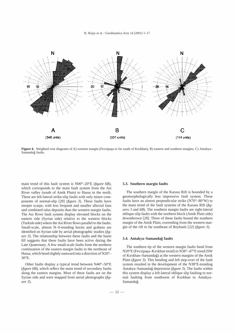
main trend of this fault system is N00°–20°E (figure 6B),which corresponds to the main fault system from the AsiRiver valley (south of Amik Plain) to Hassa in the north.These are left-lateral strike-slip faults with only minor com-ponents of normal-slip [28] (figure 3). These faults havesteeper scarps, with less frequent and smaller alluvial fansand combined talus deposits than the western margin faults.The Asi River fault system display elevated blocks on theeastern side (Syrian side) relative to the western blocks(Turkish side) where theAsi River flows parallel to the faults.Small-scale, almost N–S-trending horsts and grabens areidentified on Syrian side by aerial photographic studies (fig-ure 3). The relationship between these faults and the basinfill suggests that these faults have been active during theLate Quaternary. A few small-scale faults form the northerncontinuation of the eastern margin faults to the northeast ofHassa, which bend slightly eastward into a direction of N20°–30°E.
Other faults display a typical trend between N40°–50°E(figure 6B), which reflect the main trend of secondary faultsalong the eastern margins. Most of these faults are on theSyrian side and were mapped from aerial photographs (fig-ure 3).
5.3. Southern margin faults
The southern margin of the Karasu Rift is bounded by ageomorphologically less impressive fault system. Thesefaults have an almost perpendicular strike (N70°–80°W) tothe main trend of the fault systems of the Karasu Rift (fig-ures 3and6B). The southern margin faults are right-lateraloblique-slip faults with the northern block (Amik Plain side)downthrown [28]. Three of these faults bound the southernmargin of the Amik Plain, extrending from the western mar-gin of the rift to far southeast of Reyhanlı [22] (figure 3).
5.4. Antakya–Samandag˘ faults
The southern tip of the western margin faults bend fromN20°E (Fevzipas¸a–Kırıkhan trend) to N38°–47°E trend (SWof Kırıkhan–Samandag˘) at the western margins of the AmikPlain (figure 3). This bending and left step-over of the faultsystem resulted in the development of the N38°E-trendingAntakya–Samandag˘ depression (figure 3). The faults withinthis system display a left-lateral oblique slip faulting to nor-mal faulting from southwest of Kırıkhan to Antakya–Samandag˘.
Figure 6. Weighted rose diagrams of A) western margin (Fevzipas¸a to far south of Kırıkhan), B) eastern and southern margins, C) Antakya–Samandag˘ faults.
B. Rojay et al. / Geodinamica Acta 14 (2001) 1–17
— 12 —
Two concentrations of faults are observed in the Antakya–Samandag˘ depression. The dominant one has normal fault-ing with left-lateral strike-slip component, with a wide rangeof strike (N30°–60°E) and the second concentration hasright-lateral strike-slip faulting in a trend of N10°–20°W (fig-ure 6C).
During the course of the present study a total of 26 sliplineation data were measured in four sites along differentsegments of the major faults between Antakya and Kırıkhan(figure 3). Three of these sites are located along the faultsdisplacing Pliocene units and one displacing pre-Pliocenebasement and controlling the evolution of Quaternary depo-sition.
The first site is from the faults southwest ofAntakya (UTMcoordinates; 2 43 500 – 40 07 700) bordering the Antakya–Samandag˘ depression from south (figure 3). The faults havedeveloped in Neogene limestones and have an attitude of N42°–66°E/ 66°N with rake of 72°S.
The second site is from north of Antakya (UTM coordi-nates; 2 46 900 – 40 21 400) on N30°E/69°S dipping faultswith a rake of 34°S. These developed on Neogene clasticsbordering the Antakya–Samandag˘ depression to the north(figure 3).
The third site is north of Antakya (UTM coordinates; 2 47900 – 40 24 400) on various faults having different orienta-tions and senses. One group is of N 20°–47°E/ 66°S dippingfaults with 45°N rake. A second one is a N56°E/ 54°S dip-ping fault with pure dip slip. The third is from a N47°W/85°N dipping fault with a 36°N rake. The last is from aN46°W/ 82°S fault with a 56°S rake (figure 3).
The fourth site is from west of Kırıkhan (UTM coordi-nates; 2 54 050 – 40 40 600) on a N30°–42°E/ 70°S faultwith 76°S rake. This fault is developed between Neogeneclastics and pre-Neogene basement rock units (figure 3).
Four dominant sets of faults are detected from these mea-surements with NE–SW strike. The faults dip in two domi-nant sets of NW and SE directions. The rake amount rangesfrom 34° to 76° suggesting a normal oblique-slip faultingwith left-lateral components along the Antakya–Samandag˘depression.
6. Neotectonic characteristics of the KarasuRift
6.1. Geomorphologic Features
The Karasu Rift is a well-recognised depression boundedby highly elevated shoulders. The Amik depression, locatedat the southern part of the Karasu Rift at an altitude of 82 m,is to the widest and deepest part of the rift, and is its maindepocenter (figure 3). The major rivers (Karasu, Afrin andAsi) flow to the centre of this basin (Amik Lake), which is
drained by the Asi River into the Mediterranean Sea atSamandag˘ (figure 3).
The eastern and western margins of the rift display mor-phological differences. The western margin of the rift (theAmanos Mountains) is uplifted to a height of up to 2 250 m.Maximum morphological relief difference of the valley ismore than 2 000 m. The eastern margin, on the other hand,has relatively low topography where its maximum height is800 m. This geomorphological asymmetry reflects the asym-metric evolution of the rift valley.
The western margin is ornamented with a series of exten-sive, aligned, combined, thick alluvial fans, particularlybetween Antakya and Fevzipas¸a (figure 3). Slopes of thesealluvial fans range from 0.4° to 2°, with a radius of 2.7 to4.5 km. However, there are smaller, more recent fans withsteeper slopes of up to 4°. Most of these fans are circular,with almost no internal deformation and dissection, exceptthe fans in the vicinity of Kırıkhan and Hassa that are cut,offset and elongated by recent faulting.
The individual, en-echelon, bifurcating and braided faultpatterns (figures 2and3) gave rise to the development ofvarious young geomorphologic structures. Step-like mor-phology is a common feature along the rift margins due tothe overlapping of faults. These features are observed par-ticularly along the western margins, on both sides of theAntakya–Samandag˘ and Asi River valleys (figure 3). Elon-gated ridges and depressions are aligned parallel to the NNE–SSW-striking faults and are observed especially along thewestern margin. Long narrow morphotectonic depressionsthat are small-scale pull-aparts are located along the westernmargin of the valley between en-echelon left-lateral strike-slip faults. On the other hand, the eastern margins are mainlycontrolled by the N–S-striking straight faults along whichthe eastern blocks are uplifted (figure 3). Thus, it seems thatthe present geomorphology of the Karasu Rift is controlledby its neotectonic activity.
6.2. Young displacements along faults – amountand rate
There is no direct evidence for vertical or horizontal dis-placement along the Karasu faults. The diverted stream chan-nels displaced lavas and elevated terrace conglomerates arethe only indicators of displacements observed during thisstudy.
The sense of displacement along the faults, and in someplaces also its amount, can be detected in several cases inthe alluvium, alluvial fans, volcanic units and by recognis-ing diverted stream channels. Most of the stream channelsare generally left-laterally diverted and/or diminished alongthe fault lines indicating a sinistral motion along the faultsof Karasu Rift during the latest Quaternary period
The amounts of horizontal offset of the streams rangebetween 50 and 675 m throughout the zone. In most casesthe streams flow almost perpendicular to the faults and there-
B. Rojay et al. / Geodinamica Acta 14 (2001) 1–17
— 13 —
fore the stream offset is most probably equivalent to thestrike-slip component of faulting.
The recorded oldest age of faulting is directly deducedfrom radiometric age of the displaced volcanic rocks. Southof Hacılar Village, a basaltic lava (figures 3and5, site 7) isdisplaced vertically (55 m) and laterally (325 m) where thelava was dated as 0.08± 0.06 Ma (table II). Therefore, theminimum horizontal rate of displacement is 4.06 mm·year–1
while the vertical rate of displacement is at least 0.69mm·year–1. Accordingly, the rate of the net slip is at least4.1 mm·year–1 along this fault since 80 000 BP.
It should be noted that along the Karasu Rift no compres-sive structures are found belonging to the Quaternary period.However, to the north of the rift along the EAFZ, Quater-nary overthrusts are recognised [23, 27, 43]. Westaway andArger [24] and Yürür and Chorowicz [28] suggested thatthese structures are formed in a phase of N–S directed com-pression and were later displaced by the young activity ofthe EAFZ.
7. Discussion
The Karasu Rift has developed as a result of N–S conver-gence of the Eurasia and Arabian plates, and the westwardescape of the Anatolian Plate and the Amanos Mountainssector. The geological processes that characterise the Plio-Quaternary evolution of the Karasu Rift are the contempo-raneous volcanism, sedimentation and faulting.
Quaternary basaltic volcanism that was derived from meta-somatised asthenospheric or lithospheric mantle is mostprobably related to syn-collisional transtensional strike-slipdeformation in the Karasu Rift [eg., 38]. This is due todecompressional partial melting as the overlying continen-tal lithosphere was stretched, thinned and ruptured by theEAFZ and DST [28, 38]. The Quaternary volcanism of theKarasu Rift may have reached the earth’s surface more eas-ily along the Karasu Rift faults that are most probably fol-lowing pre-existing crustal lineaments [28, 33, 38]. How-ever, the origin of these intra-plate basalts is still the subjectof debate [e.g., 44].
The volcanism of the Karasu Rift was previously identi-fied as olivine tholeiites to quartz tholeiites and alkali oliv-ine basalts, from older to younger, respectively [28, 33, 38,39]. However, our investigations suggest that the strati-graphic order of the volcanics is different to what has beenpreviously proposed. For example, our results suggest thatthe alkali olivine basalts at Ceylanlı (N of Kırıkhan) are theoldest and the olivine tholeiites in the Körog˘lu hills are theyoungest volcanics in the Karasu Rift (figure 5, table II).Previously however, the alkali olivine basalts have been pre-sumed to be the youngest volcanics within the valley andthe olivine tholeiites to be the oldest.
There is a clear time gap between this volcanism and theNeogene volcanism in the region around Maras¸ [eg., 39].There is indeed no recorded Neogene volcanism within theKarasu Rift [33, 38, 39]. The volcanic activity in the KarasuRift during the Quaternary has been intermittent. Two cleartime gaps are present between 1.57± 0.08 Ma and0.66± 0.04 Ma, and between 0.66± 0.04 Ma and 0.42± 0.10Ma (table III).
Radiometric dating of the Quaternary volcanics of theKarasu Rift was previously in an age span of 2.10 to 0.35Ma [33]. However, there are considerable differencesbetween radiometric dates of the present study and previousstudies (table II) [33, 39]. We obtain 0.35± 0.11 Ma for thesame tholeiitic lava, sampled from the same locality (S ofFevzipas¸a) by Çapan et al [33], which was 1.17± 0.11 Maold (Sample 12 intable II). Another example is the cleardifference between Yalangöz and Körog˘lu volcanics. TheKöroglu volcanics are stratigraphically younger than theYalangöz volcanics. This is observed in the field, and led usto sample the same localities that Çapan et al [33] sampled.This field observation was later well reflected by our radio-metric dating of these volcanics. Our ages for the Yalangözvolcanics range from 0.42± 0.10 to 0.35± 0.09 Ma and0.05± 0.03 Ma for the Körog˘lu volcanics. However, thesevolcanics were considered to be the same unit and wereassigned an age of 2.10± 0.20 to 0.78± 0.10 Ma by Çapanet al [33].
The Karasu fault zone has experienced relatively recentdisplacements as clearly manifested by offset of Quaternarybasalts. A lava flow, dated as 0.08± 0.06 Ma, is displacedvertically by 55 m and left-laterally by 325 m, indicating aleft-lateral oblique-slip movement (figures 3and5). There-fore, the minimum horizontal rate of displacement is 4.06mm·year–1 while the vertical rate of displacement is at least0.69 mm·year–1. Accordingly, the rate of the net slip is mostprobably at least 4.1 mm·year–1 along this fault since 80 000years. This slip rate is smaller than most of the previous pro-posed slip rates for the EAFZ (4–10 mm·year–1 by Kuran[45]; 9 mm·year–1 by Kasapog˘lu [46]; 7.8–9 mm·year–1 byYürür and Chorowicz [28]; 29 mm·year–1 by Taymaz et al[26]; 19 mm·year–1 by Lyberis et al [23]; 6 mm·year–1 byKiratzi [47], 6 mm·year–1 by Westaway and Arger [24]) andfor the DST (6–8 mm·year–1by Garfunkel [48]; 11 mm·year–1
by Kasapog˘lu [46]; and Westaway [27]); for Gharb segmentof DST (4 to 5 mm·year–1 by Westaway and Argar [24]).This wide range of slip rate is basically computed from vari-ous kinematic models and/or seismic data. Our slip rate, 4.1mm·year–1, is only for the Karasu fault zone that links Gharbsegment of DST and EAFZ, and from a displaced 80 000-year-old lava.
A comprehensive slip lineation analysis of fault surfaces[28] concluded that two phases of deformation occurred atthe area; older N–S directed compressional phase and a morerecent E–W extensional phase. However, we could notobserve any overprinting on fault surfaces in Antakya–
B. Rojay et al. / Geodinamica Acta 14 (2001) 1–17
— 14 —
Kırıkhan sector. During the present study 26 slip lineationdata were measured where fault bends from N20°E(Fevzipas¸a–Kırıkhan trend) to N38°–47°E direction(Kırıkhan–Samandag˘ trend). The faults have NE–SW strikewith a rake of 34° to 76° suggesting a normal oblique-slipfaulting with left-lateral components. The normal compo-nent of faulting increases from north (left-lateral strike-slipfaulting with normal component, SE of Hassa) to south (nor-mal faulting with left-lateral strike-slip component, aroundAntakya). This releasing bend gave rise to the developmentof the Antakya–Samandag˘ depression, where no neotectoniccompressional components are recorded [23].
8. Conclusions
The results of the present study revealed the structure ofthe NNE-trending Karasu fault zone that binds the KarasuRift to the west and form the Karasu Rift itself.
The NNE-trending Karasu fault zone acts as a linkagezone between left-lateral transform faults, namely, the N–S-trending Gharb segment of the DST and the NE-trendingEAFZ. The northern end of the fault zone intersects the EAFZsouth of Maras¸ whereas its southern end splays out intoN30°E-trendingAntakya–Samandag˘ fault segment and N–S-trending Asi River fault segment.
The rift is developed between east dipping NNE-strikingfaults of Karasu fault zone which defines the western mar-gin of the rift, and the west dipping N–S to NNE–SSW-striking faults of DST which control the central part andeastern margin of the rift. The bend from N20°E to N47°Egave rise to the development of a releasing area where theAntakya–Samandag˘ depression developed and an asym-metrical widening of the Karasu Rift occurred during theQuaternary period. The faults within this zone display nor-mal faulting with a left-lateral component.
The asymmetry of the rift is reflected by a series of exten-sive, combined, thick alluvial fans aligned on western mar-gin and topographically elevated western rift shoulders rela-tive to eastern margin.
Quaternary fluvial to lacustrine sedimentation within therift is contemporaneous with alkali basaltic volcanismbetween 1.57± 0.08 Ma and 0.05± 0.03 Ma. This is dis-played by the intercalation of Quaternary fluvial depositswith basaltic volcanics in borehole data. In eleven boreholesout of thirty-one [42], Quaternary basaltic volcanics and flu-vial deposits are intercalated (table I). In three boreholes(no. 472, 479 and 2632), three basaltic flow units are encoun-tered with a maximum total thickness of 121 m (boreholeno. 472) (table I). On the other hand, the maximum thick-ness of Quaternary sedimentary fill is 350 m (borehole no.2929) [42].
The Quaternary volcanic field of the Karasu Rift is locatedbetween Fevzipas¸a and north of Reyhanlı. Field and bore-
hole data suggest that this volcanism is limited in spatial dis-tribution and by volume. The limits, northeast of Fevzipas¸a,and north of Amik Lake, of the volcanic field are estimatedby the presence or absence of the basaltic lavas in boreholesand in the field.
Thirteen new K-Ar dates for the Karasu Rift volcanismare provided. The age of the alkali basaltic volcanism of theKarasu Rift determined in present study (1.57± 0.08 to 0.05± 0.03 Ma) is systematically much younger than the previ-ous age determinations in the same region (2.10 to 0.35 Ma)by Çapan et al [33].
The lava flows are grouped into five phases by their agesand field relations (table III). This illustrates intermittent vol-canic activity within the Karasu Rift.
The sense of slip along the faults, and in some cases alsoits amount, can be detected in many cases in the displacedvolcanic units, elevated terrace conglomerates and divertedstream channels. Our K-Ar dates do provide new constraintson fault slip rates. The rate of left-lateral slip is calculatedapproximately as 4.1 mm·year–1 from displaced lavas whichare 80 000 years old.
Overall, the Karasu fault zone is a linkage zone betweenDST and EAFZ where basaltic volcanism has accompaniedthe faulting between 1.57± 0.08 and 0.05± 0.03 Ma.
Acknowledgements. The authors are grateful to TheScientific and Research Council of Turkey (TÜBI˙TAK) andIsrael Geological Survey for their financial support duringfield and laboratory studies with a Research Fund Project.We would like to thank Erdin Bozkurt for his patience andencouragement. And finally we would like to express ourspecial thanks to Rob Westaway and Aykut Barka for theircomments that greatly improved an earlier version of thismanuscript.
References
[1] McKenzie D.P., Active tectonics of the Mediterranean region,Geophys. J.R. Astr. Soc. 30 (1972) 109–185.[2] Sengör A.M.C., Yılmaz Y., Tethyan evolution of Turkey: aplate tectonic approach, Tectonophysics 75 (1981) 181–241.[3] Dewey J.F., Hempton M.R., Kidd W.S.F., Saroglu F.,Sqengör A.M.C., Shortening of continental lithosphere: theneotectonic of Eastern Anatolia – a young collision zone, in:Coward M.P., Ries A.C. (Eds.), Collision Tectonics, 19,Geolological Society Special Publication, London, 1986, pp. 3–36.[4] Hempton M.R., Constraints on Arabian plate motion andextensional history of the Red Sea, Tectonics 6 (1987) 687–705.[5] Le Pichon X., Gaulier J.M., The rotation of Arabia and theLevant fault system, Tectonophysics 153 (1988) 271–294.[6] Sqengör A.M.C., Türkiye’nin neotektonig˘inin esasları, Geol.Soc.Turkey Conf. Ser. 2, 1980, 40 p.[7] Le Pichon X., Angelier J., The Hellenic arc and trench system:a key to the neotectonic evolution of the eastern MediterraneanSea, Tectonophysics 60 (1979) 1–42.
B. Rojay et al. / Geodinamica Acta 14 (2001) 1–17
— 15 —

[8] Sqengör A.M.C., Görür N., Sarog˘lu F., Strike slip faulting andrelated basin formation in zones of tectonic escape: Turkey as acase study, Soc. Econ. Paleontol. Mineral. Spec. Publ. 37 (1985)227–264.
[9] Mart Y., Rabinowitz P.D., The northern Red Sea and the DeadSea Rift, Tectonophysics 124 (1986) 85–113.
[10] Joffe S., Garfunkel Z., Plate kinematics of the cırcum Red Sea– a re-evaluation, Tectonophysics 141 (1987) 5–22.
[11] Quennell A.M., The structural and geomorphic evolution ofthe Dead Sea rift, Q. J. Geol. Soc. London 114 (1958) 1–24.
[12] Quennell A.M., Tectonics of the Dead SeaRift. 20th Int. Geol.Congr., Mexico 1956, 1959, pp. 385–405.
[13] Freund R., Garfunkel Z., Zak I., Goldberg M., Weissbrod T.,Berin B., The shear along the Dead Sea rift, Phil. Trans. Roy. Soc.,London, Serie A 267 (1970) 107–130.
[14] Garfunkel Z., Zak I., Freund R., Active faulting in the DeadSea rift, Tectonophysics 80 (1981) 1–26.
[15] Freund R., Zak I., Garfunkel Z., On the age and rate ofsinistral movement along the Dead Sea rift, Nature 220 (1968)253–255.
[16] Dubertet L., Liban, Syrie et Bordure des pays voisins. Extraitdes notes et mémoires sur le moyen-orient, tome VIII. Museumnational d’histoire naturelle, 1966, 251–358.
[17] Chaimoy T.A., Barazang M., Crustal shortening in thePalmyride Fold Belt, Syria, and implications for movement alongDead Sea fault system, Tectonics 9 (1990) 1369–1386.
[18] Arpat E., Sqaroglu F., The East, Anatolian fault system:thoughts on its development, Bull. Min. Res. Expl. Inst. Turkey 78(1972) 33–39.
[19] Seymen I˙., Aydın A., Bingöl deprem fayi ve bunun KuzeyAnadolu fayı ile iliskisi, Bull. Min. Res. Expl. Inst. Turkey 79(1972) 1–8.
[20] Muehlberger R.W., The splintering of the Dead Sea fault zonein Turkey, Hacettepe Univ. Earth Sci. 8 (1981) 123–130.
[21] Jackson J., McKenzie D., Active tectonics of the Alpine–Himalayan Belt between Western Turkey and Pakistan, Geoph.J. R. Astr. Soc. 7 (1984) 185–264.
[22] Sqaroglu F., Emre Ö., Kusçu I˙., The East Anatolian fault zoneof Turkey, Annales Tectonicae 6 (1992) 99–125.
[23] Lyberis N., Yürür T., Chorowicz J., Kasapog˘lu E.,Gündogdu N., The East Anatolian fault: an oblique collisional belt,Tectonophysics 204 (1992) 1–15.
[24] Westaway R., Arger J., The Gölbas¸ı basin, southeasternTurkey: a complex discontinuity in a major strike-slip fault zone,J. Geol. Soc. London 153 (1996) 729–744.
[25] Eyidogan H., Bitlis-Zagros Bindirme KusagininSismotektonik Özellikleri, PhD thesis, I˙stanbul Tech. Univ. Fac.Mining, Istanbul, 1983.
[26] Taymaz T., Eyidog˘an H., Jackson J., Source parameters oflarge earthquakes in the East Anatolian Fault Zone (Turkey),Geophys. J. Int. 106 (1991) 537–550.
[27] Westaway R., Present day kinematics of the Middle East andEastern Mediterranean, J. Geophys. Res. 99 (1994) 12071–12090.
[28] Yürür T., Chorowicz J., Recent volcanism, tectonics and platekinematics near the junction of the African, Arabian and Anatolianplates in the eastern Mediterranean, J. Volcan. Geother. Res. 85(1998) 1–15.
[29] Perinçek D., Çemen I˙., The structural relationship betweenthe East Anatolian and Dead Sea fault zones in SoutheasternTurkey, Tectonophysics 172 (1990) 331–340.
[30] Gülen L., Barka A., Toksöz M.N., Continental collision andrelated complex deformation: Maras¸ triple junction and
surrounding structures, SE Turkey, Hacettepe Univ. Earth Sci. 14(1987) 319–336.
[31] Muehlberger R.W., Gorbon M.B., Observations on thecomplexity of the East Anatolian Fault, Turkey, J. Struct. Geol. 9(1987) 899–903.
[32] Perinçek D., Eren A.G., Dog˘rultu atımlı Dogu Anadolu veÖlü Deniz fay zonları etki alanında gelis¸en Amik havzasınınkökeni, Türkiye 8. Petrol Kongresi Bildiri Kitabi, 1990, 180–192.
[33] Çapan U.Z., Vidal P., Cantagrel J.M., K-Ar, Nd, Sr and PbIsotopic study of the Quaternary volcanism in Karasu Rift (Hatay),N-end of Dead sea rift zone in SE Turkey, Hacettepe Univ. EarthSci. 14 (1987) 165–178.
[34] Lovelock P.E.R., A review of the tectonics of the northernMiddle East region, Geological Magazine 121 (1984) 577–587.
[35] Ergin K., Guclu U., Uz Z., A catalogue of earthquakes forTurkey and surrounding area (11A.D. to 1964 A.D.). I˙stanbulTech. Univ. Fac. Mining Publ., 24, 1967.
[36] Erdik M., Aydınoglu N., PınarA., Kalafat D., Hatay DepremRaporu Kandilli Obs., I˙stanbul, 1997.
[37] Tekeli O., Erendil M., Whitechurch H., Autochthons,parautochtons and ophiolites of the Eastern Taurus and Amanosmountains 1983, Field guidebook, PUBLISHER, LOCATION,1983.
[38] Polat A., Kerrich R., Casey J.F., Geochemistry of Quaternarybasalts erupted along the East Anatolian and Dead Sea fault zonesof Southern Turkey: implications for mantle sources, Lithos 40(1997) 55–68.
[39] Arger J., Mitchell J., Westaway R.W.C., Neogene andQuaternary volcanism of southeastern Turkey, in: Bozkurt E.,Winchester J.A., Piper J.D.A. (Eds.), Tectonics and Magmatism inTurkey and the Surrounding Area, 173, Geolological SocietySpecial Publication, London, 2000, pp. 459–487.
[40] Heimann A., The development of the Dead Sea Rift and itsmargins in northern Israel during the Pliocene and the Pleistocene.Ph.D. Thesis (in Hebrew with English abstract), The HebrewUniversity, Jerusalem, 1990.
[41] Heimann A., Ron H., Geometrical changes of plateboundaries along part of the northern Dead Sea transform:geochronology and palaeomagnetic evidence, Tectonics 12 (1993)477–491.
[42] DSI Report, Asi havzası hidrojeolojik etüt raporu, 1975.
[43] Karig D.E., Kozlu H., Late, Palaeogene evolution of the triplejunction region near Maras¸, south-central Turkey, J. Geol. Soc.London 147 (1990) 1023–1034.
[44] McKenzie D.P., O’Nions R.K., The source regions of oceanisland basalts, J. Petrol. 36 (1995) 133–159.
[45] Kuran U., The location, magnitude and long-term timeprediction of damaging earthquakes along the Anatolian faults andLevant coast, Bull. Geo. Congress of Turkey 2 (1980) 151–163.
[46] Kasapog˘lu E.K., Seismotectonic characteristics of EasternMediterranean: A finite elements analysis, Hacettepe Univ. EarthSci. 14 (1987) 309–317.
[47] Kiratzi A.A., A study of the active crustal deformation of theNorth and East Anatolian fault zones, Tectonophysics 225 (1993)191–203.
[48] Garfunkel Z., Internal structure of the Dead Sea leakytransform (rift) in relation to plate kinematics, Tectonophysics 80(1981) 81–108.
[49] Barka A., Reilinger R., Active tectonics of the Mediterraneanregion: deduced from GPS, neotectonic and seismicity data,Annali Geoph. 11 (3) (1997) 587–610.
B. Rojay et al. / Geodinamica Acta 14 (2001) 1–17
— 16 —
[50] Mascle J., Chaumillon E., Pre-collisional geodynamics of theMediterranean Sea: the Mediterranean Ridge and the TyrrhenianSea, Annali Geoph. 11 (3) (1997) 569–586.[51] Mantovani E., Albarello D., Tamburelli C., Babbucci D.,Viti M., Plate convergence, crustal delimination, extrusion
tectonics and minimization of shortening work as main controllingfactors of the recent Mediterranean deformation pattern, AnnaliGeoph. 11 (3) (1997) 611–643.[52] Tolun N., Pamir H.N., Hatay. 1:500 000 ölçekli Türkiyejeoloji haritasi, M.T.A. Ankara, 1975.
B. Rojay et al. / Geodinamica Acta 14 (2001) 1–17
— 17 —