new hampshire - in re: sec docket no. 2015-06 joint … · 2017-05-15 · 1 state of new hampshire...
TRANSCRIPT
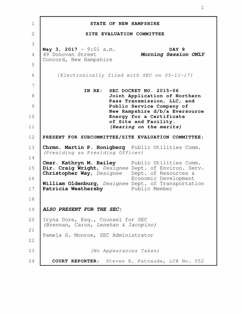
1
STATE OF NEW HAMPSHIRE
SITE EVALUATION COMMITTEE
May 3, 2017 - 9:01 a.m. DAY 8 49 Donovan Street Morning Session ONLY Concord, New Hampshire
{Electronically filed with SEC on 05-11-17}
IN RE: SEC DOCKET NO. 2015-06 Joint Application of Northern Pass Transmission, LLC, and Public Service Company of New Hampshire d/b/a Eversource Energy for a Certificate of Site and Facility. (Hearing on the merits) PRESENT FOR SUBCOMMITTEE/SITE EVALUATION COMMITTEE:
Chrmn. Martin P. Honigberg Public Utilities Comm. (Presiding as Presiding Officer) Cmsr. Kathryn M. Bailey Public Utilities Comm. Dir. Craig Wright, Designee Dept. of Environ. Serv. Christopher Way, Designee Dept. of Resources & Economic Development William Oldenburg, Designee Dept. of Transportation Patricia Weathersby Public Member
ALSO PRESENT FOR THE SEC:
Iryna Dore, Esq., Counsel for SEC (Brennan, Caron, Lenehan & Iacopino) Pamela G. Monroe, SEC Administrator
(No Appearances Taken)
COURT REPORTER: Steven E. Patnaude, LCR No. 052
1
2
3
4
5
6
7
8
9
10
11
12
13
14
15
16
17
18
19
20
21
22
23
24

2
I N D E X
PAGE NO.
WITNESS PANEL: KENNETH BOWES (resumed) DERRICK BRADSTREET LYNN FARRINGTON SAMUEL JOHNSON JOHN KAYSER NATHAN SCOTT
Cross-examination continued by Mr. Whitley 3
{SEC 2015-06} [Day 8/Morning Session ONLY] {05-03-17}
1
2
3
4
5
6
7
8
9
10
11
12
13
14
15
16
17
18
19
20
21
22
23
24

3
[Bowes~Bradstreet~Farrington~Johnson~Kayser~Scott]
P R O C E E D I N G
CHAIRMAN HONIGBERG: Good morning,
everyone. Welcome to another beautiful day
here in Concord, New Hampshire.
Is there anything we need to deal
with before we resume questioning?
[No indication given.]
CHAIRMAN HONIGBERG: All right.
Mr. Whitley, you may proceed.
MR. WHITLEY: Thank you, Mr. Chair.
Good morning, everyone.
WITNESS BOWES: Good morning.
(Continuation of the witness
panel of Kenneth Bowes, Derrick
Bradstreet, Lynn Farrington,
Samuel Johnson, John Kayser, and
Nathan Scott.)
CROSS-EXAMINATION (resumed)
BY MR. WHITLEY:
Q. Mr. Johnson, I wanted to turn back to you just
briefly. In my efforts to get us out of there
last night at a reasonable time, I went over a
question that I wanted to ask you.
A. (Johnson) Sure.
{SEC 2015-06} [Day 8/Morning Session ONLY] {05-03-17}
1
2
3
4
5
6
7
8
9
10
11
12
13
14
15
16
17
18
19
20
21
22
23
24

4
[Bowes~Bradstreet~Farrington~Johnson~Kayser~Scott]
Q. So, do you have your supplemental testimony
with you again this morning?
A. (Johnson) I do.
Q. And just for the record again, that's
Applicants' 86, I believe?
A. (Johnson) That's correct.
Q. We talked a little bit yesterday about the
Project's efforts on outreach to
municipalities. And I believe that the
testimony from this panel and from other panels
has been that that's been a real point of
emphasis. Is that correct?
A. (Johnson) Yes.
Q. While I was looking at one of the attachments
to your testimony, which is the up-to-date kind
of data on the outreach efforts, and I noted
that, in the last year and a half, so, since
January 2016, the Project has only met with
nine host communities. Does that sound
accurate?
A. (Johnson) That's about accurate, yes.
Q. If there's such an emphasis on outreach and
coming to agreement, that strikes me as a very
low number.
{SEC 2015-06} [Day 8/Morning Session ONLY] {05-03-17}
1
2
3
4
5
6
7
8
9
10
11
12
13
14
15
16
17
18
19
20
21
22
23
24

5
[Bowes~Bradstreet~Farrington~Johnson~Kayser~Scott]
A. (Johnson) So, there are many types of outreach,
whether it's phone calls, whether it's letters.
These happen to be the actual visits that we've
made with the towns. Obviously, it's their
prerogative to respond when we inquire whether
they'd like a meeting. And, as you note, these
16 -- or, 2016 and '17 lists that the towns
that have reached out to us and had an official
town meeting.
Q. So, that's not a reflection of the Project
making a decision to wait and see what the SEC
does before continuing outreach to the
municipalities?
A. (Johnson) No. Absolutely not.
Q. Thank you, Mr. Johnson.
A. (Johnson) You're welcome.
Q. I want to turn now to some of the
municipalities that I represent, and just go
through some of the Project maps and AOT maps.
And just for the panel's information again,
some of the communities that I'll be going
through are New Hampton, Pembroke, and the
Ashland Water & Sewer Department. And, so,
they're primarily all overhead portions of the
{SEC 2015-06} [Day 8/Morning Session ONLY] {05-03-17}
1
2
3
4
5
6
7
8
9
10
11
12
13
14
15
16
17
18
19
20
21
22
23
24

6
[Bowes~Bradstreet~Farrington~Johnson~Kayser~Scott]
line, Mr. Bradstreet. So, I suspect that most
of my questions will be directed at you. But,
as before, if anyone else has an answer, please
feel free to chime in.
I'm going to start with the Town of New
Hampton. And what's on the screen there is the
Project map for the Town of New Hampton. Yes.
Do you see that in front of you there on the
screen?
A. (Bradstreet) Yes, I do.
Q. Are you familiar with the scenic easement along
I-93, in Bridgewater and New Hampton?
MS. DORE: Attorney Whitley, is it an
exhibit?
MR. WHITLEY: Oh, yes. I'm sorry.
Thank you. It's Applicants' Exhibit 2,
Attachment 2. Apologies.
BY THE WITNESS:
A. (Bradstreet) As to your question about the
easement, I think I'm aware that there is an
easement. I don't know much of the specifics.
BY MR. WHITLEY:
Q. Okay. Is anyone else on the panel aware of
that easement?
{SEC 2015-06} [Day 8/Morning Session ONLY] {05-03-17}
1
2
3
4
5
6
7
8
9
10
11
12
13
14
15
16
17
18
19
20
21
22
23
24

7
[Bowes~Bradstreet~Farrington~Johnson~Kayser~Scott]
A. (Bowes) Aware of it, yes, but not the
specifics.
Q. Okay. Same answer? You shook your head.
A. (Johnson) Same answer.
Q. Okay. Thank you. I'll represent to you that
it restricts structures within that area. Does
that sound, to the extent you have familiarity
with it, does that sound accurate?
A. (Bradstreet) I guess I'm not aware of it
restricting our heights outside of that
easement.
MS. DORE: Attorney Whitley, I have
to, I'm sorry, but which page it is in
Attachment 2? There are 380 pages here.
MR. WHITLEY: It's Sheet 129.
BY MR. WHITLEY:
Q. I'm sorry, Mr. Bradstreet. Could you -- do you
want me to say the question again?
A. (Bradstreet) Yes. Please.
Q. So, my question was whether or not you're aware
that the easement restricts structures?
A. (Bradstreet) I guess the Project did a thorough
review of all the restrictions along these
easements. And, if a restriction was noted, it
{SEC 2015-06} [Day 8/Morning Session ONLY] {05-03-17}
1
2
3
4
5
6
7
8
9
10
11
12
13
14
15
16
17
18
19
20
21
22
23
24

8
[Bowes~Bradstreet~Farrington~Johnson~Kayser~Scott]
would have been incorporated into our design.
Q. Okay. Now, it appears that the structures in
this area were placed outside of or right on
the boundary of that easement. Is that
correct?
A. (Bradstreet) Looks like they're very near, yes.
Q. And, if we look to the tower information. Oh,
hold on. Let me just point out which towers
we're going to be looking at here.
So, on the New Hampton side there, just
before it crosses the Pemi River, do you see
those three towers, the three Project towers
there? So, DC-1144, --
A. (Bradstreet) Yes. In between 93 and the Pemi
River?
Q. That's correct. So, 1144, and 1143, and 1142?
A. (Bradstreet) Yes. I see that.
Q. And then the relocated 115 towers, which are
168, 169, and 170?
A. (Bradstreet) Correct.
Q. Okay. And, just to go over the heights of
those towers, the 142 is 110 feet -- the 1142,
pardon me, 110 feet; the 1143 is 105 feet; and
the 1144 is 110 feet. Correct?
{SEC 2015-06} [Day 8/Morning Session ONLY] {05-03-17}
1
2
3
4
5
6
7
8
9
10
11
12
13
14
15
16
17
18
19
20
21
22
23
24

9
[Bowes~Bradstreet~Farrington~Johnson~Kayser~Scott]
A. (Bradstreet) That looks correct, yes.
Q. And then, for the 115 towers, the 168 is
125 feet; the 169 is 100 feet; and the 170 is
115 feet. Correct?
A. (Bradstreet) Looks correct, yes.
Q. Okay. Turn now to the AOT map of this area.
And, just for the record, this is Applicants'
Exhibit 1, Appendix 6c. And this is sheet -- I
believe it's 246. Yes, 246.
And isn't it correct that, for the
structures that I've just identified and that
we've been discussing, there's going to be some
vegetative clearing associated with those
structures? I'm pulling it up a little closer
here so you can see that.
A. (Bradstreet) Yes. It looks like there's some
clearing proposed on either sides of the
existing right-of-way.
Q. Okay. So, you have a scenic easement here,
which is immediately adjacent to where these
towers are located, that restricts structures.
But, right next to that easement, you've placed
six towers, six towers with a minimum height of
100 feet and a maximum height of 125 feet.
{SEC 2015-06} [Day 8/Morning Session ONLY] {05-03-17}
1
2
3
4
5
6
7
8
9
10
11
12
13
14
15
16
17
18
19
20
21
22
23
24

10
[Bowes~Bradstreet~Farrington~Johnson~Kayser~Scott]
Isn't that accurate?
A. (Bradstreet) That's the structure heights that
are proposed, correct.
Q. And, in addition you're going to be doing some
vegetative clearing. So, while the Project may
arguably not be violating the terms of the
easement, you're certainly adding taller
structures and taking away vegetative buffer in
the exact vicinity where that easement is
located?
A. (Bradstreet) I guess I wouldn't say it's in the
"exact vicinity of the easement". But it's on
our easement, yes.
Q. So, if you're not in violation of the letter of
the easement, you're violating the spirit of
that easement?
MR. NEEDLEMAN: Objection.
CHAIRMAN HONIGBERG: Mr. Whitley.
MR. WHITLEY: The grounds for the
objection?
MR. NEEDLEMAN: How could we possibly
violate an easement when we're not on the
easement property?
MR. WHITLEY: And my question was --
{SEC 2015-06} [Day 8/Morning Session ONLY] {05-03-17}
1
2
3
4
5
6
7
8
9
10
11
12
13
14
15
16
17
18
19
20
21
22
23
24

11
[Bowes~Bradstreet~Farrington~Johnson~Kayser~Scott]
well, I'll withdraw the question. That's fine.
BY MR. WHITLEY:
Q. I want to turn now, Mr. Bradstreet, to a
different segment of the line in New Hampton.
You see that on your screen there? This is the
Project map, the revised Project map for the
Project. This is Sheet 126. And this is where
the line comes into New Hampton.
A. (Bradstreet) Yes, I see that.
Q. And I'm pulling up now Sheet 126. And you see
that, on the left-hand side of the screen there
is the Ashland Water & Sewer facility. And,
then, as you go along the line, you come into
New Hampton. Do you see that?
A. (Bradstreet) Yes, I do.
Q. The portion of the line in New Hampton there --
whoops, I keep hitting the wrong button,
apologies. The portion of the line in New
Hampton there, as you go to the right, it comes
up against I-93, correct?
A. (Bradstreet) Yes. It looks like it parallels
I-93 for maybe four or five structures, yes.
Q. Okay. But, in terms of accessing this segment
of the right-of-way, the Project is going to
{SEC 2015-06} [Day 8/Morning Session ONLY] {05-03-17}
1
2
3
4
5
6
7
8
9
10
11
12
13
14
15
16
17
18
19
20
21
22
23
24

12
[Bowes~Bradstreet~Farrington~Johnson~Kayser~Scott]
have to come from the Ashland side of the
river, correct?
A. (Bradstreet) I believe that's the plan.
Correct.
Q. And that's because, obviously, the Project's
not going to come to this portion of the
right-of-way from the I-93 --
A. (Bradstreet) Yes. We have no plans to access
the Project from a limited access highway.
Correct.
Q. Right. Right. And your AOT maps reflect this.
This is that same property there. The scale is
a little bit different. But do you see this as
the same property?
A. (Bradstreet) Yes, I believe.
MS. DORE: Attorney Whitley, what are
we looking at right now?
MR. WHITLEY: We are looking at the
AOT map, which, again, is Applicants'
Exhibit 1, Appendix 6c.
I think, for the record, can I just
say that that's going to be the citation, and
just give the page number from here on out. Is
that acceptable, Mr. Chair?
{SEC 2015-06} [Day 8/Morning Session ONLY] {05-03-17}
1
2
3
4
5
6
7
8
9
10
11
12
13
14
15
16
17
18
19
20
21
22
23
24

13
[Bowes~Bradstreet~Farrington~Johnson~Kayser~Scott]
CHAIRMAN HONIGBERG: I think, if
you're staying within one exhibit, and you're
moving within pages, it's easy enough. It's
just a little -- sometimes a little unclear if
you're changing exhibits, you're changing
documents. This is mostly for your benefit, so
your record is clear.
MR. WHITLEY: Well, let me just --
I'll put on the record then that I'm switching
between the AOT maps and the revised Project
maps. The AOT maps, again, are Applicants'
Exhibit 1, Appendix 6c. The revised Project
maps are Applicants' Exhibit 2, Attachment 2.
CHAIRMAN HONIGBERG: Okay. Thank
you.
BY MR. WHITLEY:
Q. And this is that portion of the right-of-way we
were just discussing, where access would not be
possible from where I-93 intersects the
corridor. Correct?
A. (Bradstreet) Yes. We do not plan to come off
I-93.
Q. Okay. So, then, the Project's means of access
is over or through Ashland Water & Sewer
{SEC 2015-06} [Day 8/Morning Session ONLY] {05-03-17}
1
2
3
4
5
6
7
8
9
10
11
12
13
14
15
16
17
18
19
20
21
22
23
24

14
[Bowes~Bradstreet~Farrington~Johnson~Kayser~Scott]
Department, which is back on Sheet Number 241
of the AOT Application. You see that on the
left-hand side there?
A. (Bradstreet) Yes. I think it's not crystal
clear in this picture, but, yes.
Q. I can pull up a better one here. There you go.
So, what I've put on the screen now is the
Project map, and this is again Revised Project
Sheet 126. And that's the access point to that
New Hampton property, correct?
A. (Bradstreet) Correct.
Q. Okay. And do you know what spans the Squam
River?
A. (Bradstreet) I'm sorry what -- as far as a
bridge or something? I don't know the
specifics personally.
Q. Okay.
A. (Bradstreet) I don't know if anybody else does,
but --
A. (Johnson) It's a bridge that's able to
basically handle a small tractor.
Q. Okay. Do you know the width of that bridge,
Mr. Johnson?
A. (Johnson) Off the top of my head, it's around
{SEC 2015-06} [Day 8/Morning Session ONLY] {05-03-17}
1
2
3
4
5
6
7
8
9
10
11
12
13
14
15
16
17
18
19
20
21
22
23
24

15
[Bowes~Bradstreet~Farrington~Johnson~Kayser~Scott]
six feet, something of that nature.
Q. Okay. Is it -- to your knowledge, is it
reinforced to the extent that construction
vehicles could cross it?
A. (Johnson) No.
Q. And the Project is not planning on using the
Water & Sewer Department property to access the
right-of-way currently?
A. (Johnson) We've had discussions with the Water
& Sewer Department about an access agreement in
this area. At this time, it has not been
resolved.
Q. Okay. So, if you're not using the Ashland
Water & Sewer Department property, you're going
to have to get access to the right-of-way
further north up the line, correct?
A. (Johnson) That's correct.
Q. Has the Project considered using helicopters at
all to reach the New Hampton property we're
discussing?
A. (Johnson) Only for stringing activities, which
I believe they're planning on using across the
entire program.
Q. Okay.
{SEC 2015-06} [Day 8/Morning Session ONLY] {05-03-17}
1
2
3
4
5
6
7
8
9
10
11
12
13
14
15
16
17
18
19
20
21
22
23
24
16
[Bowes~Bradstreet~Farrington~Johnson~Kayser~Scott]
A. (Johnson) But, no, not specifically for this
area. It is an option. But I do not believe
that the contractors at that point -- are at
that point at this time.
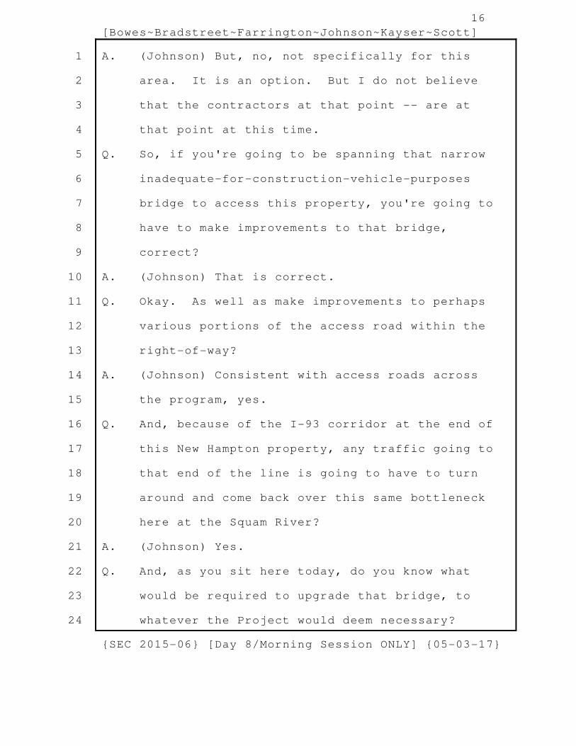
Q. So, if you're going to be spanning that narrow
inadequate-for-construction-vehicle-purposes
bridge to access this property, you're going to
have to make improvements to that bridge,
correct?
A. (Johnson) That is correct.
Q. Okay. As well as make improvements to perhaps
various portions of the access road within the
right-of-way?
A. (Johnson) Consistent with access roads across
the program, yes.
Q. And, because of the I-93 corridor at the end of
this New Hampton property, any traffic going to
that end of the line is going to have to turn
around and come back over this same bottleneck
here at the Squam River?
A. (Johnson) Yes.
Q. And, as you sit here today, do you know what
would be required to upgrade that bridge, to
whatever the Project would deem necessary?
{SEC 2015-06} [Day 8/Morning Session ONLY] {05-03-17}
1
2
3
4
5
6
7
8
9
10
11
12
13
14
15
16
17
18
19
20
21
22
23
24

17
[Bowes~Bradstreet~Farrington~Johnson~Kayser~Scott]
A. (Johnson) I do not personally.
Q. Does anyone else on the panel? Mr. Bradstreet?
A. (Bradstreet) I do not know. No.
Q. When would that information be available?
A. (Johnson) The contractor, in this case, PAR
Electric, would have to go out and assess the
conditions of that bridge, and then propose a
new solution. Any bridge replacement, I
believe, is consistent with a culvert
replacement, with the rules and regulations
associated with that, which have to be cleared
by the Department of Environmental Services
prior to installation.
Q. Okay. I want to walk through some of the other
line portions in New Hampton. And I'm going to
turn now to the AOT plans, Sheet 254. Let me
zoom out here, so it's a better perspective.
Do you have that in front of you,
Mr. Bradstreet?
A. (Bradstreet) Yes, sir.
Q. Okay. So, for these portions of the
transmission corridor, to the north there, the
Pemi River, and then you're going to access
that northern segment via Old Bristol Road, as
{SEC 2015-06} [Day 8/Morning Session ONLY] {05-03-17}
1
2
3
4
5
6
7
8
9
10
11
12
13
14
15
16
17
18
19
20
21
22
23
24

18
[Bowes~Bradstreet~Farrington~Johnson~Kayser~Scott]
well as the southern segment that goes to the
right of the picture, correct?
A. (Bradstreet) So, you're saying both from Old
Bristol Road, north and south?
Q. Yes.
A. (Bradstreet) So, the plan would be to head
north --
[Court reporter interruption.]
BY THE WITNESS:
A. (Bradstreet) The plan would be to head north
off of Old Bristol Road, as well as south.
BY MR. WHITLEY:
Q. Okay. This will give you a better view of
that. And, so, I see the two aprons there onto
Old Bristol Road. But there is also an off
right-of-way access towards the bottom of the
picture, you see that?
A. (Bradstreet) Yes. I believe that's the access
to the existing Pemigewasset Substation.
Q. Okay. Okay. Because that was one of my
questions, was what was the purpose for that
off right-of-way access?
A. (Bradstreet) I think it's just because it's
existing.
{SEC 2015-06} [Day 8/Morning Session ONLY] {05-03-17}
1
2
3
4
5
6
7
8
9
10
11
12
13
14
15
16
17
18
19
20
21
22
23
24

19
[Bowes~Bradstreet~Farrington~Johnson~Kayser~Scott]
Q. Okay. So, assuming you get your approval and
the Project is approved, is that off
right-of-way access going to remain then?
A. (Bradstreet) It exists today. So, yes.
Q. Okay.
A. (Bowes) It's for the existing substation, not
necessarily for the transmission construction.
Q. And that's what I gathered from
Mr. Bradstreet's answer, but I just wanted to
be clear.
A. (Bradstreet) I guess, to clarify further, the
area, I guess, to the east of the substation
would most likely be removed, like the rest of
the transmission access roads. But the drive
from Old Bristol Road would remain.
Q. Okay. And would that drive from Old Bristol
Road have any sort of security associated with
it? Gates, anything like that? Does it
currently?
A. (Bradstreet) I would assume it does not. The
substation has the fencing required.
Q. And the apron to access the northern segment
appears to extend into Old Bristol Road. Is
that accurate? And, by "extend", I mean it
{SEC 2015-06} [Day 8/Morning Session ONLY] {05-03-17}
1
2
3
4
5
6
7
8
9
10
11
12
13
14
15
16
17
18
19
20
21
22
23
24

20
[Bowes~Bradstreet~Farrington~Johnson~Kayser~Scott]
extends -- it appears to be at least halfway
into Old Bristol Road?
A. (Bradstreet) I think it appears to be halfway
into the right-of-way boundary, but not
necessarily into the road itself.
Q. Okay.
A. (Bradstreet) The apron would start at the edge
of pavement, or I believe it's paved here.
Q. Okay. So, going through these various AOT
maps. There's a couple places where the apron
appears to extend into the right-of-way
boundary of a road. But it sounds like your
answer is that, when it appears that way on the
plan, it's actually just going to be to the
edge of the pavement?
A. (Bradstreet) That would be the intent here. I
think you can kind of make out the road
alignment in the photo.
Q. Uh-huh.
A. (Bradstreet) So, there's some distance between
the edge of right-of-way and the edge of
pavement.
Q. Okay. Because the right-of-way boundary of the
road and the edge of the traveled way may not
{SEC 2015-06} [Day 8/Morning Session ONLY] {05-03-17}
1
2
3
4
5
6
7
8
9
10
11
12
13
14
15
16
17
18
19
20
21
22
23
24

21
[Bowes~Bradstreet~Farrington~Johnson~Kayser~Scott]
be the same thing?
A. (Bradstreet) Right. And the purpose of this
apron is to make sure we have adequate access
for trucks to turn off of the pavement onto the
access road.
Q. And do you know how wide Old Bristol Road is at
this access point?
A. (Bradstreet) I do not. But I think we can get
a measurement real quick.
A. (Johnson) About 25 to 30 feet.
Q. Okay. And, so, when you have construction
vehicles accessing either the northern portion
or the southern portion of the corridor,
there's going to be a potential to block both
lanes of traffic due to the narrowness of this
road?
A. (Bradstreet) I guess I don't know if the
sequence would ever require both directions at
the same time. We can definitely coordinate
that so that I think it would not happen.
Q. But assume, just for the sake of this
conversation, that you've got a crane truck
that's got to turn into the northern segment or
the southern segment of this corridor. So,
{SEC 2015-06} [Day 8/Morning Session ONLY] {05-03-17}
1
2
3
4
5
6
7
8
9
10
11
12
13
14
15
16
17
18
19
20
21
22
23
24

22
[Bowes~Bradstreet~Farrington~Johnson~Kayser~Scott]
that would require a pretty wide turning
radius, would it not?
A. (Bradstreet) It would.
Q. And is a 25 to 30-foot traveled way enough of a
turning radius to get onto either segment
without blocking the other lane of travel?
A. (Bradstreet) Again, I think it can be
coordinated so that it does not block travel.
I would say this is the same as a semi truck
turning into, you know, a general entrance to
any kind of construction area or an entrance
into a business even.
Q. Ms. Farrington, I'm going to turn to you for a
second. I understand from yesterday's
testimony, I think it was yesterday, that you
haven't done any analysis of how much traffic
to expect at these access points, is that
correct?
A. (Farrington) That is correct.
Q. And, so, that answer would carry over to the
Town of New Hampton and these access points we
see here?
A. (Farrington) Correct. We don't expect the
number of vehicles accessing these points at
{SEC 2015-06} [Day 8/Morning Session ONLY] {05-03-17}
1
2
3
4
5
6
7
8
9
10
11
12
13
14
15
16
17
18
19
20
21
22
23
24

23
[Bowes~Bradstreet~Farrington~Johnson~Kayser~Scott]
any given period of time, perhaps like a peak
hour, to be substantial enough to warrant any
sort of analysis.
Q. Okay. But you haven't done any calculation of
traffic impact at this specific location
though?
A. (Farrington) No, I have not.
Q. I believe yesterday, Mr. Bradstreet, when we
were talking about similar access points, there
was some testimony about gravel mud traps on
these aprons. Do you recall that?
A. (Bradstreet) I don't recall specifically. But,
yes, I know what you're talking of.
Q. Okay. I don't see those indicated on any of
the maps. Is there a particular reason for
that?
A. (Bradstreet) I don't think it was specifically
called out. But the plan would be for gravel
traps to be I think it's 15 feet of the first
entryway of an access road from the road. So,
15 feet from the road, into the access, would
be that mud trap area.
Q. Okay. Okay. Because I -- to save time this
morning, I mean, I didn't see gravel mud traps
{SEC 2015-06} [Day 8/Morning Session ONLY] {05-03-17}
1
2
3
4
5
6
7
8
9
10
11
12
13
14
15
16
17
18
19
20
21
22
23
24

24
[Bowes~Bradstreet~Farrington~Johnson~Kayser~Scott]
indicated on any of these plans. So, I just
wanted to clarify that that was the Project's
intent, was to have those gravel mud traps at
all of these aprons where access is provided to
the right-of-way?
A. (Bradstreet) Somebody can correct me if I'm
wrong on the panel, but, yes, I believe that is
the plan. I believe that is what's shown on
the details that the contractor will be
required to follow.
Q. Okay. Thank you. Are any of you aware of the
status of this road? And, by "status", I mean
"Class V", "Class VI".
A. (Bradstreet) I am not.
A. (Bowes) No, I'm not.
Q. Okay.
A. (Johnson) Not.
Q. Do any of you have any knowledge about the
significance of that status designation?
A. (Johnson) As you get higher in numbers, it's,
you know, less maintained and not -- at a point
where it's not plowed in the winter.
Q. That's partially correct, Mr. Johnson, yes.
So, this road is a Class V road. And I'll
{SEC 2015-06} [Day 8/Morning Session ONLY] {05-03-17}
1
2
3
4
5
6
7
8
9
10
11
12
13
14
15
16
17
18
19
20
21
22
23
24

25
[Bowes~Bradstreet~Farrington~Johnson~Kayser~Scott]
represent to you that that means that it's a
public road, but that is maintained by the
Town. And it sounds like that's consistent
with at least your understanding, Mr. Johnson?
A. (Johnson) It is.
Q. Are any of you aware of whether or not the Town
of New Hampton has seasonal weight
restrictions?
A. (Bradstreet) I would assume they do.
Q. But not specifically, though?
A. (Bradstreet) I mean, the Project will research
what the requirements are and incorporate that
into the construction schedule.
Q. But, as you sit here today, has the Project
done that research, to your knowledge?
A. (Bradstreet) I know I have not. I don't know,
Sam, if you have a better answer?
A. (Johnson) No. The answer is, to date, no.
Q. Okay. I'll represent to you that the New
Hampton seasonal weight restriction is a limit
of 10 tons on the roads that they have
designated as needing that protection. It's
likely that there will be vehicles and loading
on those vehicles that will exceed that amount,
{SEC 2015-06} [Day 8/Morning Session ONLY] {05-03-17}
1
2
3
4
5
6
7
8
9
10
11
12
13
14
15
16
17
18
19
20
21
22
23
24

26
[Bowes~Bradstreet~Farrington~Johnson~Kayser~Scott]
isn't that correct?
A. (Bradstreet) For construction, at times, yes.
There will most likely be larger vehicles than
that.
Q. And, so, what will the Project do if it needs
to move those construction vehicles and
equipment into this segment of the
right-of-way, and it happens to be during the
weight restriction season in town?
A. (Bradstreet) I think that's part of our
construction coordination schedule effort. We
will schedule this work to make sure that we
are not there when those restrictions would
impede work.
Q. But I understand that there's, I guess, a bit
of a difference between, you know, hoping to
not have to violate a seasonal weight
restriction and committing to not violating a
seasonal weight restriction. And I'm hoping
that you can clarify which one the Project is
offering to do?
A. (Bradstreet) I guess I'll voice my opinion, and
somebody can weigh in if they have other
thoughts. But the purpose of the construction
{SEC 2015-06} [Day 8/Morning Session ONLY] {05-03-17}
1
2
3
4
5
6
7
8
9
10
11
12
13
14
15
16
17
18
19
20
21
22
23
24
27
[Bowes~Bradstreet~Farrington~Johnson~Kayser~Scott]
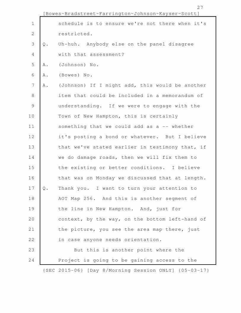
schedule is to ensure we're not there when it's
restricted.
Q. Uh-huh. Anybody else on the panel disagree
with that assessment?
A. (Johnson) No.
A. (Bowes) No.
A. (Johnson) If I might add, this would be another
item that could be included in a memorandum of
understanding. If we were to engage with the
Town of New Hampton, this is certainly
something that we could add as a -- whether
it's posting a bond or whatever. But I believe
that we've stated earlier in testimony that, if
we do damage roads, then we will fix them to
the existing or better conditions. I believe
that was on Monday we discussed that at length.
Q. Thank you. I want to turn your attention to
AOT Map 256. And this is another segment of
the line in New Hampton. And, just for
context, by the way, on the bottom left-hand of
the picture, you see the area map there, just
in case anyone needs orientation.
But this is another point where the
Project is going to be gaining access to the
{SEC 2015-06} [Day 8/Morning Session ONLY] {05-03-17}
1
2
3
4
5
6
7
8
9
10
11
12
13
14
15
16
17
18
19
20
21
22
23
24

28
[Bowes~Bradstreet~Farrington~Johnson~Kayser~Scott]
corridor. Do you see that there,
Mr. Bradstreet?
A. (Bradstreet) Yes, I do.
Q. And, so, the Project is going to be using Brook
Road for this AOT map, this map segment, to
access the corridor, correct?
A. (Bradstreet) Correct.
Q. And that's going to be accessing the segment
that's to the left in the picture, and then
I'll, you know, represent to you that the
segment continues to the right beyond what's
shown here?
A. (Bradstreet) Yes, sir.
Q. Yes. I count three aprons at this access
point. Why do you need three aprons here?
A. (Bradstreet) I believe the plan is for the
apron to the left to access that span that
continues and runs to the north. One of the
aprons to the right is probably going to be the
main access point to continue south. And the
third apron is to access that single structure
that's directly off of Brook Road.
Q. Why can't you link up the two construction pads
here and do away with one of those access
{SEC 2015-06} [Day 8/Morning Session ONLY] {05-03-17}
1
2
3
4
5
6
7
8
9
10
11
12
13
14
15
16
17
18
19
20
21
22
23
24
29
[Bowes~Bradstreet~Farrington~Johnson~Kayser~Scott]
aprons?
A. (Bradstreet) I think there's an opportunity for
that.
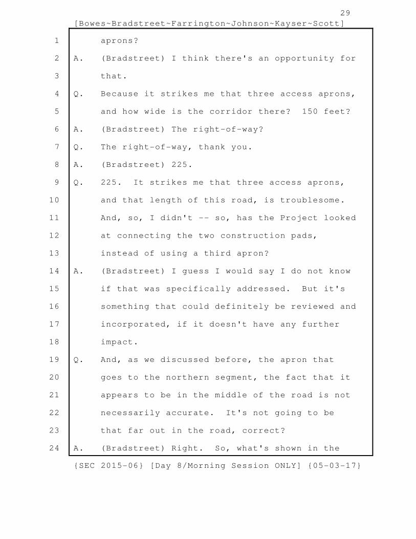
Q. Because it strikes me that three access aprons,
and how wide is the corridor there? 150 feet?
A. (Bradstreet) The right-of-way?
Q. The right-of-way, thank you.
A. (Bradstreet) 225.
Q. 225. It strikes me that three access aprons,
and that length of this road, is troublesome.
And, so, I didn't -- so, has the Project looked
at connecting the two construction pads,
instead of using a third apron?
A. (Bradstreet) I guess I would say I do not know
if that was specifically addressed. But it's
something that could definitely be reviewed and
incorporated, if it doesn't have any further
impact.
Q. And, as we discussed before, the apron that
goes to the northern segment, the fact that it
appears to be in the middle of the road is not
necessarily accurate. It's not going to be
that far out in the road, correct?
A. (Bradstreet) Right. So, what's shown in the
{SEC 2015-06} [Day 8/Morning Session ONLY] {05-03-17}
1
2
3
4
5
6
7
8
9
10
11
12
13
14
15
16
17
18
19
20
21
22
23
24

30
[Bowes~Bradstreet~Farrington~Johnson~Kayser~Scott]
middle of the road is based off of the parcel
boundary. And, if you could clearly see the
edge of the pavement, it would match up with
the pavement.
Q. Okay. Okay. And are you guys aware of how
wide Brook Road is here?
A. (Bradstreet) One second.
Q. Sure.
A. (Bradstreet) Approximately 25 feet.
Q. I'm sorry, Mr. Bradstreet. You said "25 feet",
I believe?
A. (Bradstreet) Approximately 25 feet, yes.
Q. Okay. And is that measurement the traveled way
or is that the road corridor?
A. (Bradstreet) I believe that's the pavement.
Q. Okay. And, again, Ms. Farrington, you're not
aware of any -- you haven't done any
calculation on the expected amount of traffic
here, nor have you done a calculation of
possible traffic impact at this location?
A. (Farrington) That's correct. So, if I may, it
might help if I explain a little bit of how the
traffic analysis would be done.
Q. Ms. Farrington, I just wanted you to answer the
{SEC 2015-06} [Day 8/Morning Session ONLY] {05-03-17}
1
2
3
4
5
6
7
8
9
10
11
12
13
14
15
16
17
18
19
20
21
22
23
24

31
[Bowes~Bradstreet~Farrington~Johnson~Kayser~Scott]
question that I asked. Thank you.
A. (Farrington) Okay.
Q. And, Mr. Bradstreet, again, the plan doesn't
show any gravel mud traps, but it sounds like
that is what is indeed planned, correct?
A. (Bradstreet) Yes. Every access point off of a
main road will have that gravel mud trap at the
beginning.
Q. Okay. Does the Project have any awareness of
what the designation of this road is?
A. (Bradstreet) I do not.
A. (Johnson) No.
Q. I heard the click, so I looked up. I'll
represent to the panel that this is a Class V
road as well. Does the panel have any
knowledge of whether this is a paved road, a
gravel road, anything like that?
A. (Johnson) It looks to be a gravel road.
Q. Okay. But you're basing that on what?
A. (Johnson) On the Google images.
Q. Okay. So, has anyone on the panel traveled to
this segment of the road?
A. (Johnson) I have not, no. Our constructability
gentlemen -- or, people have been out in the
{SEC 2015-06} [Day 8/Morning Session ONLY] {05-03-17}
1
2
3
4
5
6
7
8
9
10
11
12
13
14
15
16
17
18
19
20
21
22
23
24

32
[Bowes~Bradstreet~Farrington~Johnson~Kayser~Scott]
field, and, yes, have walked through this.
Q. They have walked this segment?
A. (Johnson) Yes.
Q. Okay. So, similar to the last road we spoke
about, this road, too, could be subject to the
seasonal weight restrictions?
A. (Bradstreet) Yes. I believe that's correct.
Q. All right. I want to turn now to another
segment. This one is AOT Map 259. And, just
for context, it's that red square there in the
bottom left. Oh, apologies. That's the wrong
segment. One more. There we go. So, this is
still AOT 259, I just pulled up the wrong page
for the record.
Okay. You see that there, Mr. Bradstreet?
A. (Bradstreet) Yes, sir.
Q. I'll zoom out, so you get a little more context
here. So, in this segment, the right-of-way is
accessed via Coolidge Woods Road, correct?
A. (Bradstreet) Yes. It appears so.
Q. And, as before, Ms. Farrington, you're not
aware of any expected traffic here, nor have
you done a calculation of possible traffic
impact, correct?
{SEC 2015-06} [Day 8/Morning Session ONLY] {05-03-17}
1
2
3
4
5
6
7
8
9
10
11
12
13
14
15
16
17
18
19
20
21
22
23
24

33
[Bowes~Bradstreet~Farrington~Johnson~Kayser~Scott]
A. (Farrington) Correct.
Q. Is anyone on the panel aware of the status of
Coolidge Woods Road?
A. (Bradstreet) I am not.
A. (Johnson) I'm going to guess it's a Class V?
Q. You are correct, Mr. Johnson. Yes. It's Class
V. Is anyone aware of the surface of the road,
whether it's paved, gravel?
A. (Johnson) It appears to be gravel.
Q. And is anyone aware what the width of the road
is?
A. (Johnson) I just measured, and it's 25 feet as
well.
Q. And that is, again, the traveled portion, not
the corridor, correct?
A. (Johnson) That's correct.
Q. So, you're aware that this road, too, is
subject to that seasonal weight limitation?
A. (Johnson) Yes, sir.
Q. All right. I want to turn to another road
segment now. This is going to be AOT Map
Number 246. And we looked at this a little
earlier this morning. This is the segment of
the corridor right before it crosses the Pemi
{SEC 2015-06} [Day 8/Morning Session ONLY] {05-03-17}
1
2
3
4
5
6
7
8
9
10
11
12
13
14
15
16
17
18
19
20
21
22
23
24

34
[Bowes~Bradstreet~Farrington~Johnson~Kayser~Scott]
River and goes into Bridgewater. But I want to
talk right now about the access via Highway
132. Do you see that, Mr. Bradstreet?
A. (Bradstreet) Yes, I do.
Q. I can zoom in. And here as well there's off
right-of-way access. What's the purpose of
that off right-of-way access onto that
construction pad?
A. (Johnson) So, there's a relatively steep slope
that goes from 132 as it heads towards the
Pemigewasset River. That is land that's owned
by PSNH. And, so, it's a existing access road
that allows for a more gentler slope, if you
will, for vehicles to access those two
structures down in the plateau of the
Pemigewasset River.
Q. So, you said it's presently existing, it's not
planned for this Project?
A. (Johnson) So, I believe PSNH currently uses
that as a maintenance access road. There will
have to be some improvements. But they will be
removed when the Project is complete.
Q. And there's a -- so, it accesses the bottom
side on the picture of that construction pad,
{SEC 2015-06} [Day 8/Morning Session ONLY] {05-03-17}
1
2
3
4
5
6
7
8
9
10
11
12
13
14
15
16
17
18
19
20
21
22
23
24

35
[Bowes~Bradstreet~Farrington~Johnson~Kayser~Scott]
correct? That off right-of-way access?
A. (Johnson) Yes. It appears to be that, yes.
Q. But the other side, the upper portion of that
construction pad, is accessed via an apron
within the corridor from 132, correct?
A. (Johnson) That would -- that's correct, yes.
Q. Okay. My understanding from yesterday is that,
when the Project prepares a construction pad,
that you clear that area and level the site, is
that accurate?
A. (Johnson) For the most part, yes.
Q. Okay. So, if you're leveling the construction
pad, and you have access via either the off
right-of-way access or the apron, then why do
you need a second access point?
A. (Johnson) Good question. I think just to keep
options available.
Q. Okay.
A. (Johnson) I believe that, in the beginning, we
may use the access road off of 132 for smaller
vehicles that would get in. And, then, once
the heavy machinery comes in for drilling and
structure erection, then it would come off the
longer access road.
{SEC 2015-06} [Day 8/Morning Session ONLY] {05-03-17}
1
2
3
4
5
6
7
8
9
10
11
12
13
14
15
16
17
18
19
20
21
22
23
24

36
[Bowes~Bradstreet~Farrington~Johnson~Kayser~Scott]
Q. Okay.
A. (Johnson) As you can see in the plan, the
contour lines are fairly close together. So,
there is a slope that comes down that way. So
it would not be conducive to any kind of heavy
type of machinery.
Q. So, that answer seems at odds with the one you
gave initially.
A. (Johnson) So, the clearing activities or the
survey crews, for example, would use pickup
trucks. So, it would be very easy for them to
come down a little slope and get to that level.
Q. But, if you have access that's suitable for a
larger piece of equipment, those smaller
vehicles could use that access as well?
A. (Johnson) Absolutely, yes. Yes. No question.
I think the optionality was the only reason
there's two here.
Q. Okay. Okay. So, other than convenience,
there's no engineering need for that third
access point?
A. (Johnson) That's correct.
Q. Okay. And the off right-of-way access, is
there any plan to remove that, assuming the
{SEC 2015-06} [Day 8/Morning Session ONLY] {05-03-17}
1
2
3
4
5
6
7
8
9
10
11
12
13
14
15
16
17
18
19
20
21
22
23
24

37
[Bowes~Bradstreet~Farrington~Johnson~Kayser~Scott]
Project goes forward?
A. (Johnson) Yes.
Q. Okay. And, while the Project is under
construction, is that going to be secured in
any way?
A. (Johnson) I don't know. We could certainly
look into putting a gate up or something of
that nature, so that other folks wouldn't use
it.
Q. I guess I'm a little confused, because I
thought that was already the plan of the
Project, was to make sure that, by doing the
work in the corridor, the Project wasn't
opening up access points to unauthorized use of
the corridor. And, so, the way to combat that
and prevent that from happening was that
right-of-way access was going to be limited and
secure. Is that -- do I have that
understanding incorrectly?
A. (Bowes) I think, in general, that's correct.
Q. Okay.
A. (Bowes) It doesn't mean we're going to install
gates at every location, especially if PSNH
uses that access now.
{SEC 2015-06} [Day 8/Morning Session ONLY] {05-03-17}
1
2
3
4
5
6
7
8
9
10
11
12
13
14
15
16
17
18
19
20
21
22
23
24

38
[Bowes~Bradstreet~Farrington~Johnson~Kayser~Scott]
Q. What does it mean, if it doesn't mean a gate?
What does it mean then?
A. (Bowes) It means we may not be putting gates up
at this location.
Q. Well, how are you securing it, if you're not
putting a gate up? What's the alternative?
A. (Bowes) We would not.
A. (Johnson) We could post "No Trespassing" signs,
etcetera.
Q. Okay. That's not really the same thing as
securing access.
A. (Johnson) Agreed.
A. (Bowes) So, my experience is just installing a
gate just leads to a alternative path around
the gate. And signage, although may satisfy a
legal requirement, it really tends not to be
very effective, if someone wants to access the
right-of-way.
Q. Okay. So, maybe do nothing then?
A. (Bowes) It may be best to do nothing in this
case.
Q. I want to stay in the Town of New Hampton and
just talk a little bit about noise impacts for
a second. And I don't know who I should direct
{SEC 2015-06} [Day 8/Morning Session ONLY] {05-03-17}
1
2
3
4
5
6
7
8
9
10
11
12
13
14
15
16
17
18
19
20
21
22
23
24

39
[Bowes~Bradstreet~Farrington~Johnson~Kayser~Scott]
these questions to, Mr. Bowes or
Mr. Bradstreet, is --
A. (Bowes) Probably the two of us.
Q. Okay. Okay. So, are either of you aware that
New Hampton has some regulations restricting
noise in town?
A. (Bowes) It would not surprise me, but I don't
specifically know, --
Q. Okay.
A. (Bowes) -- if there's ordinances, regulations,
or more detailed regulations.
Q. Mr. Bradstreet, any different answer?
A. (Bradstreet) No. I would agree with what
Mr. Bowes just said.
Q. Okay. I'll represent to you both that they do
have such an ordinance. And that, in
residential areas, there is a dBA limitation at
the property line that is 60 dBA by day and 50
dBA by night. And, when I say "dBA", I'm sure
you know what I'm referring to?
A. (Bradstreet) Yes.
A. (Bowes) Yes, sir. It's a sound pressure level,
yes.
Q. Yes. And they define daytime as "7:00 a.m. to
{SEC 2015-06} [Day 8/Morning Session ONLY] {05-03-17}
1
2
3
4
5
6
7
8
9
10
11
12
13
14
15
16
17
18
19
20
21
22
23
24

40
[Bowes~Bradstreet~Farrington~Johnson~Kayser~Scott]
8:00 p.m", and then, obviously, nighttime is
the remaining hours, "8:00 p.m. back to
7:00 a.m." And I've pulled up here Project Map
127, revised Project Map 127 for the Project.
And you see the yellow dots above and below the
corridor there. Those are residential uses,
correct?
A. (Bradstreet) Yes, I believe so.
Q. Zoom in to give you a better view here. So,
you see, for this segment of the line, which
runs across the center of the page there, there
are a couple of residences that are -- that
appear to be right on the edge of the
right-of-way. And I'm looking at the two
yellow dots below the corridor on the picture,
and to the left-hand side of the page. One has
a property designation of "6115" and the other
one has a property designation of "6117". Do
you see those?
A. (Bowes) I do.
Q. And wouldn't you agree that those residences
appear to be just outside the right-of-way?
A. (Bowes) That is correct.
Q. And the two towers -- the two Project towers or
{SEC 2015-06} [Day 8/Morning Session ONLY] {05-03-17}
1
2
3
4
5
6
7
8
9
10
11
12
13
14
15
16
17
18
19
20
21
22
23
24

41
[Bowes~Bradstreet~Farrington~Johnson~Kayser~Scott]
structures that are closest to those two
residences are DC-1124 and DC DC-1125, correct?
A. (Bradstreet) Yes. That looks correct.
Q. Okay. And then we go up and just look at the
specifics for those towers. And, again, it was
1124 and 1125. So, 1124 is going to be 95 feet
tall and 1125 is going to be 90 feet tall,
correct?
A. (Bradstreet) It appears so, yes.
Q. And they correspond with C218, which is the one
that's right here in the center. And, from
that segment, it appears that the Project line
is roughly 85 feet from the edge of the
right-of-way. Is that correct?
A. (Bradstreet) That's correct.
Q. And, again, those houses are right on the edge
of the right-of-way. So, those houses are
roughly 85 feet from the Project towers,
correct?
A. (Bradstreet) They're slightly further, but,
yes.
Q. Yes. And, going back to the Project Map view
here, this is a residential area. So,
arguably, the town's noise limitations would
{SEC 2015-06} [Day 8/Morning Session ONLY] {05-03-17}
1
2
3
4
5
6
7
8
9
10
11
12
13
14
15
16
17
18
19
20
21
22
23
24

42
[Bowes~Bradstreet~Farrington~Johnson~Kayser~Scott]
apply?
A. (Bowes) Would you happen to have a copy of that
ordinance that you could put up?
Q. I don't have it electronically, unfortunately.
A. (Bowes) So, oftentimes, the noise ordinances
exclude construction noise. I'm just wondering
if that's the case for this town?
Q. This one -- this one does not, no. No. Is
there any noise mitigation planned for work in
this area, from the construction?
A. (Bowes) Yes. There's obviously some things on
this picture that would dominate the local
noise, with the I-93, and it looks to be an
active quarry. That aside, the Project still
will take noise mitigation measures. A report
was actually done as part of the DOE Draft EIS
process that outlined all of the types of
construction, the vehicles used, and the amount
of noise that they generate.
Q. So, let's just -- let's talk about what type of
activity these residences --
A. (Bowes) Sure.
Q. -- could expect. So, there's going to be tree
clearing, potentially?
{SEC 2015-06} [Day 8/Morning Session ONLY] {05-03-17}
1
2
3
4
5
6
7
8
9
10
11
12
13
14
15
16
17
18
19
20
21
22
23
24

43
[Bowes~Bradstreet~Farrington~Johnson~Kayser~Scott]
A. (Bowes) So, for right-of-way clearing, there
would be several types of equipment used. Each
one of those is listed on, in this case, Data
Table 10 of that report.
Q. Uh-huh.
A. (Bowes) And it gives an SPL, or sound pressure
level, for each type of equipment. And also
does what I think is very nice is that it gives
distances away from that equipment. So, you
can actually see what the sound level impact of
each type of equipment at, say, 100 feet,
200 feet, etcetera, away.
Q. But, if we could, Mr. Bowes, I want to get back
to the types of activity.
A. (Bowes) Yes.
Q. So, you said site preparation or tree clearing?
A. (Bowes) So, the right-of-way clearing would be
one, yes.
Q. Right. There would be some other prep of the
access roads or improvement to the access roads
that could involve heavy equipment?
A. (Bowes) Yes. That would be part of the
right-of-way activity, yes.
Q. Okay. But that could include use of a
{SEC 2015-06} [Day 8/Morning Session ONLY] {05-03-17}
1
2
3
4
5
6
7
8
9
10
11
12
13
14
15
16
17
18
19
20
21
22
23
24

44
[Bowes~Bradstreet~Farrington~Johnson~Kayser~Scott]
bulldozer?
A. (Bowes) Yes. That's actually one of the pieces
of equipment that's noted in this data table.
Q. Okay. There could be large crane trucks
delivering equipment?
A. (Bowes) Not in this phase, but that would be a
later phase.
Q. Okay.
A. (Bowes) The next phase I would refer you to
would be the foundation portion of the Project.
And, again, all of the types of equipment used
for foundations, that's actually found in Data
Table 11. Then, the next would be the
structure assembly, --
Q. Uh-huh.
A. (Bowes) -- which is found in Data Table 12.
Data Table 13 goes into the construction noise
from wire stringing. Those are the basic
activities. And then you'd have some of the
same activities for the right-of-way clearing
to remove those roads. So, there's probably
five different phases of construction noise
activities.
Q. And you said that mitigation was currently
{SEC 2015-06} [Day 8/Morning Session ONLY] {05-03-17}
1
2
3
4
5
6
7
8
9
10
11
12
13
14
15
16
17
18
19
20
21
22
23
24

45
[Bowes~Bradstreet~Farrington~Johnson~Kayser~Scott]
planned in some areas, noise mitigation, that
is?
A. (Bowes) Well, for all of the areas, there's
some type of noise mitigation, yes.
Q. Okay. And I want to know, for this particular
area, does the panel have any sense of what
noise mitigation will be planned for here?
A. (Bowes) Yes.
Q. And what would that be?
A. (Bowes) So, the first thing would be limiting
the construction work hours. As you mentioned,
we're actually, it sounds like, inside the
noise ordinance for this town. So, we're
saying "7:00 a.m. to 7:00 p.m.", not -- I think
you said "8:00 p.m." for this town.
Q. Correct.
A. (Bowes) So, that's the first thing you would do
is limit the construction activity hours. The
next thing is making sure that all the
equipment used meets either federal or state
requirements for noise emissions. Most of
those are federal requirements, but, in New
Hampshire, the DOT also adopts some of those,
so making sure that all the equipment is within
{SEC 2015-06} [Day 8/Morning Session ONLY] {05-03-17}
1
2
3
4
5
6
7
8
9
10
11
12
13
14
15
16
17
18
19
20
21
22
23
24

46
[Bowes~Bradstreet~Farrington~Johnson~Kayser~Scott]
its legal limits.
Q. If I could just interject, Mr. Bowes. So, when
you say "compliance with state and federal
guidelines" and equipment being, I guess, up to
those specs, do I understand that that the
equipment that's going to be used, when it
arrives on-site, it will have the noise
mitigation kind of already built into it?
A. (Bowes) Correct. The type of mufflers or type
of silencers used for the equipment would be
designed into the work equipment itself.
Q. Okay.
A. (Bowes) The next thing we'd do is make sure
each morning that the equipment was functional.
All the mufflers were intact, that there was no
erratic operations of the equipment. And
sometimes you can easily tell when an equipment
is malfunctioning by the amount of noise it's
generating. That equipment would be removed
from service immediately.
Part of the construction outreach would
also be going on to these homes, probably about
six weeks before construction, and describing
what types of activities would take place.
{SEC 2015-06} [Day 8/Morning Session ONLY] {05-03-17}
1
2
3
4
5
6
7
8
9
10
11
12
13
14
15
16
17
18
19
20
21
22
23
24

47
[Bowes~Bradstreet~Farrington~Johnson~Kayser~Scott]
And, in that week of construction, we would go
out and knock on the doors again and let the
residents know that we were coming, the type of
work we would be doing, if there were any
issues that we needed to be aware of. And, so,
we'd work on a case-by-case basis along the
right-of-way to ensure that we tried to
minimize the impacts. If they had a particular
issue that they were dealing with on a
particular day, we could stand down for that
period of time, for example.
Q. Thank you.
A. (Bowes) So, those are some of the mitigations
we would take, in general. And that's not just
for this location, but it would be for all of
the overhead right-of-way construction.
Q. I want to turn the panel's attention to another
segment in town. This is Project Map 136.
And, just for context here -- oh, this one,
that's right, doesn't have the little area shot
there. But, as you see from what's on the
screen there, this is where the line runs from
New Hampton into the Town of Hill by crossing
the Pemi River. Do you see that?
{SEC 2015-06} [Day 8/Morning Session ONLY] {05-03-17}
1
2
3
4
5
6
7
8
9
10
11
12
13
14
15
16
17
18
19
20
21
22
23
24

48
[Bowes~Bradstreet~Farrington~Johnson~Kayser~Scott]
A. (Bradstreet) Yes, sir.
Q. Okay. And, again, in this area, you see the
yellow circles, which are residences that are
somewhat near to the line or the corridor. Do
you see that?
A. (Bradstreet) Yes, I see some.
Q. And I want to direct your attention to -- you
see the little elbow that the corridor makes at
the top of the screen there, there are yellow
dots that are, let's see, in between Structure
DC-1201 and DC-1202. Do you see that one?
A. (Bradstreet) Yes.
Q. And, then, across Coolidge Woods Road, there's
another house that is across the road from
DC-1201. Do you see that?
A. (Bradstreet) So, basically, kind of directly
above the designation "A111" in the map shown?
Q. No. No. You want too far.
A. (Bradstreet) Oh. Above DC-1201, okay. Yes, I
see it.
Q. Yes. Just want to go and get the specifics on
those towers, when my computer let's me. There
we go.
So, DC-1201 and 02: 1201 is 90 feet, 1202
{SEC 2015-06} [Day 8/Morning Session ONLY] {05-03-17}
1
2
3
4
5
6
7
8
9
10
11
12
13
14
15
16
17
18
19
20
21
22
23
24

49
[Bowes~Bradstreet~Farrington~Johnson~Kayser~Scott]
is 70 feet?
A. (Bradstreet) That looks correct.
Q. Both those are represented by segment C225,
which is right in the middle of the page here.
And you see that the Project line, similar to
the last segment, appears to be about 85 feet
from the right-of-way boundary?
A. (Bradstreet) Correct.
Q. Other than what you just described, Mr. Bowes,
is there any other specific noise mitigation
that is planned for this portion of the line?
A. (Bowes) There is not.
Q. But, again, it would be some of the same
activities going on here that you previously
described, correct?
A. (Bowes) Actually, all of the same activities,
yes.
Q. Yes. Okay. I want to change gears now for a
second and talk about the engineering study
that was conducted at the Ashland Water & Sewer
Department facility. That, I believe, had a
draft date of March 29, 2017. Is anyone on the
panel familiar at all with that?
A. (Bowes) Yes, I am.
{SEC 2015-06} [Day 8/Morning Session ONLY] {05-03-17}
1
2
3
4
5
6
7
8
9
10
11
12
13
14
15
16
17
18
19
20
21
22
23
24

50
[Bowes~Bradstreet~Farrington~Johnson~Kayser~Scott]
Q. Okay. Anyone else, other than Mr. Bowes?
A. (Bradstreet) I think we all are.
Q. Okay.
A. (Johnson) Move it this way.
Q. Okay. And, when you gentlemen said that you're
familiar, is it just a rough familiarity or
have you actually reviewed the report?
A. (Bowes) I have reviewed the report.
A. (Johnson) I have as well.
A. (Bradstreet) Yes.
Q. Same to you, okay. Okay. And did any of you
have a role in providing input to Nobis
Engineering in the preparation of that report?
A. (Bradstreet) I did not.
A. (Bowes) I reviewed an earlier draft of the
report.
A. (Johnson) I reviewed an earlier draft of the
report.
Q. Okay. And did either of you give comments to
Nobis Engineering after reviewing that initial
draft?
A. (Bowes) Yes, I did.
A. (Johnson) Yes, I did.
Q. Okay. And what were the nature of those
{SEC 2015-06} [Day 8/Morning Session ONLY] {05-03-17}
1
2
3
4
5
6
7
8
9
10
11
12
13
14
15
16
17
18
19
20
21
22
23
24

51
[Bowes~Bradstreet~Farrington~Johnson~Kayser~Scott]
comments?
A. (Bowes) To draw to a conclusion at the end,
which they have done, I guess they have come up
with six or seven conclusions. They had done
the analysis, but hadn't -- ultimately, we need
to have a conclusion for the impacts of the
Project.
Q. And I'm going to pull it up shortly, Mr. Bowes.
So, we will discuss it in a little more detail.
A. (Johnson) My comments were more editorial in
nature.
Q. Okay. So, what I've pulled up on the screen is
that report. Does that look accurate to you?
That's the one that you most recently reviewed?
A. (Bowes) Yes. It does look like the same
report.
Q. And do you see on the bottom there, it's the
March 29, 2017?
A. (Bowes) Yes. That's the report I have.
Q. Is this the most recent version of that report?
A. (Bowes) Yes, it is.
Q. Okay.
MS. DORE: Could you tell us what
exhibit number it is?
{SEC 2015-06} [Day 8/Morning Session ONLY] {05-03-17}
1
2
3
4
5
6
7
8
9
10
11
12
13
14
15
16
17
18
19
20
21
22
23
24

52
[Bowes~Bradstreet~Farrington~Johnson~Kayser~Scott]
MR. WHITLEY: This is going to be
"Joint Municipality 195" [sic - Jt. Muni 201].
This was just recently disclosed to us, which
is why you don't have it as of yet.
BY MR. WHITLEY:
Q. Okay. I want to turn to the limitations that
the report has indicated. And this is Page 27
of that report. Well, I take that back. It's
Page 27 of the PDF. You gentlemen see that on
the screen there?
A. (Johnson) Yes.
Q. One of the limitations that struck me was
Number 2. So, I'll give you a chance to just
read that real quick. And it basically says
that the soil profile that's described is
"generalized", "intended to convey trends in
subsurface conditions", "the boundaries between
particular strata are approximate", but that
"actual soil transitions are probably more
erratic". Is that accurate?
A. (Bowes) Yes.
Q. And -- I'll withdraw that. Let's go down now
to Number 5. Give you a second to just read
that. So, in Number 5, Nobis is recommending
{SEC 2015-06} [Day 8/Morning Session ONLY] {05-03-17}
1
2
3
4
5
6
7
8
9
10
11
12
13
14
15
16
17
18
19
20
21
22
23
24

53
[Bowes~Bradstreet~Farrington~Johnson~Kayser~Scott]
additional work at this property. That
correct?
A. (Bowes) Yes, they are.
Q. Have they been engaged to do that work as of
yet?
A. (Bowes) Not at this time. Once the final
report is done, then the Project will certainly
evaluate that.
Q. But, as you sit here today, they have not been
retained to do anything further, other than
provide a final version of this report?
A. (Bowes) That is correct.
Q. Okay. I want to pull up right now a figure
that was provided as part of this report. And
it is Figure 2 to the report, and it's on Page
25 of the PDF. And I'll blow it up, because I
know it's small.
So, the Project in this area, and by "this
area" I mean in the area of the four lagoons
you see there, is going to consist of three new
structures within the right-of-way. And that
would be DC-110 [DC-1110?], 111 [1111?], and
112 [1112?], and then, further to the south,
DC-113 [DC-1113?]. Do you see all those?
{SEC 2015-06} [Day 8/Morning Session ONLY] {05-03-17}
1
2
3
4
5
6
7
8
9
10
11
12
13
14
15
16
17
18
19
20
21
22
23
24

54
[Bowes~Bradstreet~Farrington~Johnson~Kayser~Scott]
A. (Bowes) Yes.
Q. And DC-10 -- DC-1110, 1111, and 1112 are
adjacent to the lagoons, and DC-1113 is farther
from the lagoons, but closer to the settling
tanks, which are those two round circles just
above the red dotted line. Correct?
A. (Bowes) Yes.
Q. And I believe the report itself states that
DC-1112 is the closest of those structures to
any of the lagoons. And the report states that
it's 75 feet from the Water & Sewer Department
fencing, and about 110 feet to the edge of
Lagoon 2. That accurate?
A. (Bowes) It sounds about right, yes. Subject to
check.
Q. And, Mr. Johnson, are you doing that checking
right now?
A. (Witness Johnson nodding in the affirmative).
A. (Bowes) Looks accurate, yes.
Q. Okay. Okay. Can I -- it strikes me as odd
that, when I ask questions or when other people
ask questions about dimensions, details of
clearing, those sorts of things, that the panel
is not referring to the plans that all of us
{SEC 2015-06} [Day 8/Morning Session ONLY] {05-03-17}
1
2
3
4
5
6
7
8
9
10
11
12
13
14
15
16
17
18
19
20
21
22
23
24

55
[Bowes~Bradstreet~Farrington~Johnson~Kayser~Scott]
have at our disposal, but is referring to some
other source of information that we don't have
access to and that the Committee won't have
access to. And I just wonder if -- if the
Committee is to evaluate the evidence,
shouldn't they have the most accurate
information to do that?
A. (Bowes) So, knowing that the previous
questioner we offered to bring this up, we
didn't make that offer for you. We certainly
can project what we're looking at.
Q. But I don't mean "projecting it". I mean
allowing the parties and the Committee the
ability to manipulate it as they may need to
do. And that has not been offered to my
knowledge?
A. (Bowes) That is correct.
MR. NEEDLEMAN: Well, I'll note that,
for the record, it's the same information
everybody has, it's just in the GIS format, so
that you can access it and measure it. But you
all have the information.
MR. WHITLEY: Well, I -- I don't want
to argue. Okay.
{SEC 2015-06} [Day 8/Morning Session ONLY] {05-03-17}
1
2
3
4
5
6
7
8
9
10
11
12
13
14
15
16
17
18
19
20
21
22
23
24

56
[Bowes~Bradstreet~Farrington~Johnson~Kayser~Scott]
BY MR. WHITLEY:
Q. So, the description here in the engineering
report describes that the structures that are
going to be in the right-of-way here are all
lattice towers. They're going to have a base
of roughly 30 by 30. And they're going to be
anchored to four foundations at the corners,
roughly 3 to 5 feet in diameter each. Is that
accurate?
A. (Bradstreet) Yes. That's true.
Q. But the exact type of foundation is currently
not known. And, as I understand, the Project
could do either a concrete grilled [drilled?]
shafts or a grillage foundation. Is that
accurate?
A. (Bradstreet) So, for lattice towers right now,
the Project is considering the option for
either a drilled shift, like you said, which is
a drilled concrete shaft foundation, or a
grillage, which is buried steel, basically.
Q. Okay. But both of those foundation types
involve some sort of digging in the subsoil and
laying an adequate foundation for the towers?
A. (Bradstreet) In general, any foundation
{SEC 2015-06} [Day 8/Morning Session ONLY] {05-03-17}
1
2
3
4
5
6
7
8
9
10
11
12
13
14
15
16
17
18
19
20
21
22
23
24
57
[Bowes~Bradstreet~Farrington~Johnson~Kayser~Scott]
requires digging.
Q. True. Is there one of those methods that
requires drilling further into the subsurface?
A. (Bradstreet) So, drilled shafts would typically
be deeper than a grillage.
Q. How much deeper?
A. (Bradstreet) It depends.
Q. Just roughly, can you say?
A. (Bradstreet) It could be the same, it could be
10 feet, it could be 20 feet. It depends.
Q. And does that depend on the site-specific
conditions that the Project may encounter?
A. (Bradstreet) That's exactly what it depends on.
Q. The report goes on to describe whether or not
the lagoons are lined, and, if so, what they
are lined with. Is that correct?
A. (Bowes) That is correct.
Q. And there's a bit of a -- I don't want to say
confusion, but there's a bit of a inconsistency
between the various historical documents that
were attached to the report and that were the
basis for some of the report, correct?
A. (Bowes) Yes. The original design documents
indicated it was a clay liner. The
{SEC 2015-06} [Day 8/Morning Session ONLY] {05-03-17}
1
2
3
4
5
6
7
8
9
10
11
12
13
14
15
16
17
18
19
20
21
22
23
24

58
[Bowes~Bradstreet~Farrington~Johnson~Kayser~Scott]
investigation found that it is not a clay
liner.
Q. Well, Mr. Bowes, I thought the original designs
indicated asphalt?
A. (Bowes) Oh. I'm sorry. You're correct.
Q. Yes. The original drawings, from 1967, I
believe, indicated asphalt lined the lagoons.
Subsequent documents from New Hampshire DES and
another engineering firm that worked with the
Department to get a Groundwater Discharge
Permit, described the lining as "unlined".
I'll represent to you that the Water &
Sewer Department believes that they're, in
fact, lined with clay. But that question,
about what is, in fact, the lining, was not
determined by this report, correct?
A. (Bowes) That is correct.
Q. So, I just mentioned that the Water & Sewer
Department needed to get a Groundwater
Discharge Permit, and they had to do that
through DES. And, as part of that Discharge
Permit process, the Department installed sentry
wells to monitor and evaluate potential impacts
to groundwater and surface water from the
{SEC 2015-06} [Day 8/Morning Session ONLY] {05-03-17}
1
2
3
4
5
6
7
8
9
10
11
12
13
14
15
16
17
18
19
20
21
22
23
24

59
[Bowes~Bradstreet~Farrington~Johnson~Kayser~Scott]
lagoons. Do you agree with that?
A. (Bowes) That is correct. The lagoons lose
approximately 50,000 gallons a day to
groundwater.
Q. True. But I want to stay on the sentry wells
for just one second, Mr. Bowes.
A. (Bowes) The wells are there to monitor that
leakage out of the lagoons.
Q. I know. But we're going to come back to that.
So, just hold on one second please.
So, if you're looking at Figure 2, those
sentry wells are indicated by the light blue
"MW", and then the little hatch mark -- there's
probably an engineering term for that little
circle with the -- what is that?
A. (Bowes) I think it's a monitoring well.
Q. Yes. But, I mean, there's a name for the
circle with the -- never mind. Anyway, so,
Monitoring Well 14, Monitoring Well 15, 16, 17,
if you look above the lagoons in the picture,
you see two more, 13 and 18. And I'll
represent to you there's an additional
monitoring well that's further to the top of
the picture where the town waste or landfill is
{SEC 2015-06} [Day 8/Morning Session ONLY] {05-03-17}
1
2
3
4
5
6
7
8
9
10
11
12
13
14
15
16
17
18
19
20
21
22
23
24

60
[Bowes~Bradstreet~Farrington~Johnson~Kayser~Scott]
located. Is that accurate?
A. (Bowes) I will accept there's another one. I'm
not sure I saw the one you said was off the
page?
Q. Oh, no. Well, yes. It's here [indicating].
It's right there.
A. (Bowes) Okay.
Q. Very top, "MW-12". And, as you mention,
Mr. Bowes, there is -- one of the historical
documents, there's a memo from DES in 2005.
And it suggests that the lagoons lose roughly
50,000 gallons per day via infiltration to the
groundwater, correct?
A. (Bowes) Yes. I see a 1997 study that indicates
that.
Q. Yes. There may be more than one. But, yes.
But the number is correct?
A. (Bowes) That's the estimate, I believe. You
know, more than a decade ago, or two decades
ago, if it was '97.
Q. So, do you think that number is no longer
accurate then?
A. (Bowes) I think it could be higher, yes.
Q. And what do you base that on?
{SEC 2015-06} [Day 8/Morning Session ONLY] {05-03-17}
1
2
3
4
5
6
7
8
9
10
11
12
13
14
15
16
17
18
19
20
21
22
23
24

61
[Bowes~Bradstreet~Farrington~Johnson~Kayser~Scott]
A. (Bowes) Just that, if there were liners placed
within the lagoons, and they have deteriorated,
I would just assume that they would have
extensive deterioration since 1997.
Q. Okay. But you don't have any data that you're
using to make that assumption?
A. (Bowes) I do not.
Q. Okay.
A. (Bowes) The report did not detail that data.
Q. Okay. Thank you. So, Nobis did some testing
in and around the lagoons. And they did some
boring holes, and they fitted several of those
boring holes with monitoring wells. And, if
you look at Figure 2 again, the borings and
monitoring wells that Nobis installed are the
black circle wells, and they have numbers, if
you look to the right of the lagoon, it's
"B-1", and then "Monitoring Well 1", and then
lower, "B-5 (Monitoring 3)". Go to the other
side of the lagoons, on the left-hand side, and
starting from the bottom, "B-7 (Monitoring Well
4)", "B-2 (Monitoring Well 2)", and then "B-10
(Monitoring Well 6)". And then the last one at
the top there is "B-8 (Monitoring Well 5)". Do
{SEC 2015-06} [Day 8/Morning Session ONLY] {05-03-17}
1
2
3
4
5
6
7
8
9
10
11
12
13
14
15
16
17
18
19
20
21
22
23
24

62
[Bowes~Bradstreet~Farrington~Johnson~Kayser~Scott]
you see all those?
A. (Bowes) Yes, I do.
Q. And you'll see below the lagoons, there's a
couple of borings where they don't have the
monitoring well designation next to them. And
those are in light green. And those are looks
like all centered just below Lagoon 4. And
those are "B-3", "B-9", "B-4", and "B-6".
Correct?
A. (Bowes) Yes.
Q. And the report mentions that they had wanted to
put monitoring wells at those locations as
well, but couldn't, because they ran into some
subsurface interference and couldn't drill down
deep enough. Is that correct?
A. (Bowes) Subject to check, I would agree with
that. I don't recall that specifically.
Q. And the purpose -- one of the purposes of the
monitoring wells was to get a sense of the
groundwater flow from the lagoon area and just
see where it went. Is that a fair statement?
A. (Bowes) Yes.
Q. And one of the conclusions they came to is that
the groundwater flow roughly goes towards the
{SEC 2015-06} [Day 8/Morning Session ONLY] {05-03-17}
1
2
3
4
5
6
7
8
9
10
11
12
13
14
15
16
17
18
19
20
21
22
23
24

63
[Bowes~Bradstreet~Farrington~Johnson~Kayser~Scott]
Pemigewasset River. The way this is oriented
it's tough to tell, but that's a southwesterly
direction towards the river. Is that accurate?
A. (Bowes) Yes. I believe that's what they
concluded.
Q. The same testing, as well as some historical
data that the Department had, they tested for
certain contaminants at these well locations.
Correct?
A. (Bowes) Yes.
Q. And they found elevated levels of chloride and
nitrate in some of the locations. Wouldn't you
agree?
A. (Bowes) Yes.
Q. And that, looking at the data that was at their
disposal, it indicated an upward trend in those
contaminant amounts. Is that also correct?
A. (Bowes) That is correct.
Q. So, after performing this study, Nobis
concluded that there was going to be no adverse
effect on the performance of the lagoons. Is
that correct?
A. (Bowes) From the installation of the new
structures, that's correct.
{SEC 2015-06} [Day 8/Morning Session ONLY] {05-03-17}
1
2
3
4
5
6
7
8
9
10
11
12
13
14
15
16
17
18
19
20
21
22
23
24
64
[Bowes~Bradstreet~Farrington~Johnson~Kayser~Scott]
Q. Right. And I take it that the panel agrees
with that assessment?
A. (Bowes) I would say I'll wait for the final
report. But, in general, I would say I tend to
agree with that analysis.
Q. What is your hesitation?
A. (Bowes) Just that it's not a final report at
this point.
Q. Do you anticipate anything changing from this
version to the final report?
A. (Bowes) Not that I'm aware of, no.
Q. Okay. So, out of an abundance of caution,
you're just reserving judgment until you see
the final report?
A. (Bowes) Exactly.
Q. The report's conclusions, though, are a little
tenuous, because we don't know what lining is
really underneath all these lagoons, do we?
A. (Bowes) So, that's the -- you know, the
recommendation or Finding (b) in the report,
which would be to do some further analysis to
determine, first, if it's lined or not, and the
condition of the lining. I think that was more
for the operation of the wastewater plant than
{SEC 2015-06} [Day 8/Morning Session ONLY] {05-03-17}
1
2
3
4
5
6
7
8
9
10
11
12
13
14
15
16
17
18
19
20
21
22
23
24

65
[Bowes~Bradstreet~Farrington~Johnson~Kayser~Scott]
it was a determination whether the Northern
Pass Transmission line would impact it.
Q. But Nobis is currently not tasked with doing
any further work?
A. (Bowes) We had the discussion further or
previously around that issue. It's probably
not Northern Pass's job to assess the condition
of the wastewater treatment facility. So,
although they made those recommendations, they
may be better applied to the Town, rather than
to Northern Pass.
Q. Well, the Town is not proposing to run a new
transmission structure, though, right next to
the wastewater treatment facility, is it?
A. (Bowes) No, and I didn't mean to imply that.
Just that it seems like they have a failing
system, this report has identified that. And
it's maybe something maybe they should consider
repair or replacement of.
Q. Correct me if I'm wrong, but I don't recall
seeing in the report any sort of an evaluation
of impacts on the property within the corridor.
Actually, let me restate that. I don't recall
seeing in the report impacts of construction
{SEC 2015-06} [Day 8/Morning Session ONLY] {05-03-17}
1
2
3
4
5
6
7
8
9
10
11
12
13
14
15
16
17
18
19
20
21
22
23
24

66
[Bowes~Bradstreet~Farrington~Johnson~Kayser~Scott]
activities to the subsurface area that is below
the Project corridor.
A. (Bowes) Other than the foundations, I think
you're correct.
Q. Okay. So, the focus of the report was really
on the lagoons themselves and the other assets
of the Water & Sewer Department?
A. (Bowes) And the installation of the line
adjacent to that.
Q. And does the report have any evaluation of the
characteristics of the soil immediately below
the lagoons?
A. (Bowes) I'm not familiar with what the soil
sampling results showed.
Q. Okay. And are you aware of whether there is
any similar evaluation of soil characteristics
in the corridor area?
A. (Bowes) At this point, I do not believe there
are. We will be doing soil sampling for those
foundation locations, again, to determine the
type of foundation needed.
Q. But you haven't done that to date though?
A. (Bowes) No. I don't believe we've done that.
Q. Okay. When do you anticipate doing that, do
{SEC 2015-06} [Day 8/Morning Session ONLY] {05-03-17}
1
2
3
4
5
6
7
8
9
10
11
12
13
14
15
16
17
18
19
20
21
22
23
24

67
[Bowes~Bradstreet~Farrington~Johnson~Kayser~Scott]
you know? Is that the contractor?
A. (Johnson) Yes. It would probably be
spring/summer of next year.
Q. Okay. Isn't it true that this report doesn't
really address how work within the Project
corridor could impact the Town's monitoring
wells that are in light blue there?
A. (Bowes) So, the final recommendation of the
report talks about those wells. And it clearly
says that we need to be very careful working
around them, to ensure that they are still
functional, because that's a requirement for, I
believe, the permit with New Hampshire DES.
Q. Pulling up now the Ashland Alteration of
Terrain package, which I will orient, one
second. And, for the record, I'm going to go
to the Ashland AOT Sheet 240.
CHAIRMAN HONIGBERG: Off the record.
[Brief off-the-record discussion
ensued.]
BY MR. WHITLEY:
Q. Does the panel see that the AOT maps indicate
the construction pads for those four tower
structures that were also displayed in the
{SEC 2015-06} [Day 8/Morning Session ONLY] {05-03-17}
1
2
3
4
5
6
7
8
9
10
11
12
13
14
15
16
17
18
19
20
21
22
23
24

68
[Bowes~Bradstreet~Farrington~Johnson~Kayser~Scott]
engineering report at Figure 2?
A. (Bowes) Yes.
Q. Okay. And, so, I'm just going to flip back to
the other one just to reorient us here.
A. (Bowes) Yes. I'm doing the same thing, so I
can see them side-by-side.
Q. Yes. So, again, what I really want to talk
about is the three towers that are right below
the lagoon. So, that's 1110, 1111, and 1112,
and also -- excuse me -- the Department's
monitoring wells, which are nearby those
structures. And the ones that I'm concerned
about again are MW-14, 15, 16, and 17. Do you
see that, Mr. Bowes?
A. (Bowes) I do.
Q. Okay. So, if we look back at the AOT plan, you
see the three construction pads there. What
are the dimensions of those construction pads
roughly?
A. (Bowes) We'll get you the exact dimensions.
For the center one, it's 100 by 120. So,
that's the approximate for all three.
Q. Okay. Okay. And, as you sit here, will that
construction pad impact the monitoring wells
{SEC 2015-06} [Day 8/Morning Session ONLY] {05-03-17}
1
2
3
4
5
6
7
8
9
10
11
12
13
14
15
16
17
18
19
20
21
22
23
24

69
[Bowes~Bradstreet~Farrington~Johnson~Kayser~Scott]
that are adjacent to it? So, for the center
structure, that would be either Monitoring Well
15 or 16?
A. (Bowes) Does not appear it will directly
impact. But I would say it would indirectly
impact both 15 and 16.
Q. Okay. And a similar question, Mr. Bowes, for
the DC-1110 structure pad. And, again, there
it is to the left, and I believe you said it
was "120 by 30"?
A. (Bowes) 100.
Q. One hundred. Oh, pardon me.
A. (Bowes) It would directly impact that
structure, DC-1110.
Q. So, it would directly impact MW-14?
A. (Bowes) It would.
Q. Okay. And, for structure DC-1112, let's look
at the pad. We're concerned about MW-17,
though. And, as you sit here, do you believe
it will impact directly MW-17?
A. (Bowes) It would directly impact that
Monitoring Well 17.
Q. Okay.
A. (Bowes) So, in this case, both of the outside
{SEC 2015-06} [Day 8/Morning Session ONLY] {05-03-17}
1
2
3
4
5
6
7
8
9
10
11
12
13
14
15
16
17
18
19
20
21
22
23
24

70
[Bowes~Bradstreet~Farrington~Johnson~Kayser~Scott]
pads will have to be relocated --
Q. Okay.
A. (Bowes) -- to accommodate those monitoring
wells.
Q. Okay.
A. (Bowes) And we're going to have to install
special protection for all four of these wells
during the construction phase.
Q. Okay. And when do you plan to make those plan
corrections?
A. (Bowes) So, I know we had a couple from
yesterday. I think we're going to commit to
making those updates, say, within the next 30
days, get those filed with the SEC.
Q. Okay. And you mentioned the indirect impacts
to MW-15 and MW-16. And I wanted to come back
to these two, because they appear, from the
engineering report satellite photo, and I
presume it's a satellite photo, that they are
very close to the access roads. And is that
what you meant by "indirect impact" or were you
referring to something else?
A. (Bowes) It was both the access roads and the
pad itself.
{SEC 2015-06} [Day 8/Morning Session ONLY] {05-03-17}
1
2
3
4
5
6
7
8
9
10
11
12
13
14
15
16
17
18
19
20
21
22
23
24

71
[Bowes~Bradstreet~Farrington~Johnson~Kayser~Scott]
Q. Okay.
A. (Bowes) But I would agree that they will
definitely be impacted, though, not physically,
directly impacted.
Q. And is there any plan to alter the access roads
in the corridor to avoid MW-15 and 16? And
I'll pull up the AOT map again there.
A. (Bowes) Again, now that we have close to a
final report, I would say we're in a position
to have those discussions with the wastewater
treatment facility. I would suggest that we do
monitor -- or, both monitor the condition
adjacent to those wells, but also shift the
access away from them.
Q. I mean, I can represent to you that I think the
Department's going to want the access road
moved so that there's no impact.
A. (Bowes) And we would certainly want to
accommodate that request.
Q. I guess I'm concerned that "accommodating" is
maybe not the same thing as "committing". And
I don't know if you're in a position to make a
commitment at this time?
A. (Bowes) I am. That we would definitely commit
{SEC 2015-06} [Day 8/Morning Session ONLY] {05-03-17}
1
2
3
4
5
6
7
8
9
10
11
12
13
14
15
16
17
18
19
20
21
22
23
24

72
[Bowes~Bradstreet~Farrington~Johnson~Kayser~Scott]
to doing that.
Q. Okay. Thank you. Does anyone on the panel
know when the existing one --
MR. WHITLEY: Actually, you know
what, this would be a good time. I withdraw
that question. Sorry.
CHAIRMAN HONIGBERG: All right.
We're going to take our morning break, come
back in ten or fifteen minutes. Off the
record.
[Brief off-the-record discussion
ensued.]
[Recess taken at 10:30 a.m. and
the hearing reconvened at 10:48
a.m.]
MS. BAILEY: Mr. Whitley, you may
proceed.
MR. WHITLEY: Thank you.
BY MR. WHITLEY:
Q. So, right before we went to break I started
asking a question, and I'll pick up back there.
This corridor has an existing 115 line in it
presently, correct?
A. (Bowes) Yes.
{SEC 2015-06} [Day 8/Morning Session ONLY] {05-03-17}
1
2
3
4
5
6
7
8
9
10
11
12
13
14
15
16
17
18
19
20
21
22
23
24

73
[Bowes~Bradstreet~Farrington~Johnson~Kayser~Scott]
Q. Okay. And it's represented in the AOT and also
on the engineering study -- well, different
colors, but it's the one that's closer to the
lagoons, correct?
A. (Bowes) That is correct.
Q. Okay. Do we know when that 115 was built?
A. (Bowes) Specifically, no. But, based upon the
construction type out there, I'd say the
1950s/1960s vintage.
Q. Okay.
A. (Bowes) We can certainly found out, if you'd
like.
Q. Okay. So, it predates likely the construction
of the lagoons and the wastewater treatment
facility?
A. (Bowes) Probably, yes.
Q. Okay?
A. (Bowes) I'm not sure specifically, though.
Q. Okay. And the Nobis report was looking at a
limited dataset. I believe it was 2012 to
2016, does that sound accurate?
A. (Bowes) For the -- I see, for the groundwater
samples, yes.
Q. Yes.
{SEC 2015-06} [Day 8/Morning Session ONLY] {05-03-17}
1
2
3
4
5
6
7
8
9
10
11
12
13
14
15
16
17
18
19
20
21
22
23
24

74
[Bowes~Bradstreet~Farrington~Johnson~Kayser~Scott]
A. (Bowes) Yes.
Q. And the Town had some historical data beyond
that time period, correct?
A. (Bowes) I believe they do, yes. It's in the
back, towards the back of the report.
Q. Right. But the Nobis report -- the scope of
the Nobis report was not to look at whether and
to what extent the 115 lines may have any
impact on the flow of groundwater away from the
lagoons, towards the Pemi River?
A. (Bowes) I think that's accurate. It was not
included in the report.
Q. Okay. So, there is a possibility, wouldn't you
agree, currently unaddressed, that the
construction of the 115 lines may have played
some role in the lagoons, the amount of
groundwater that is escaping from the lagoons
and heading towards the Pemi River?
A. (Bowes) I guess, theoretically possible, highly
unlikely. I mean, the foundations or the pole
depths are maybe six or seven feet here.
Q. Okay. Are you -- is anyone on the panel aware
of what the Department uses to monitor and
control and operate the wells? And by "what
{SEC 2015-06} [Day 8/Morning Session ONLY] {05-03-17}
1
2
3
4
5
6
7
8
9
10
11
12
13
14
15
16
17
18
19
20
21
22
23
24

75
[Bowes~Bradstreet~Farrington~Johnson~Kayser~Scott]
they use", I mean are you aware that they use
an electronic system to gather that data?
A. (Bowes) I am not aware.
Q. Okay. I believe they refer to it, and it's an
acronym, and it's "SCADA", S-C-A-D-A. Does
that sound familiar?
A. (Bowes) I'm familiar with the acronym, yes. We
use the same type of equipment to monitor the
electric power system.
Q. Okay. Okay. Well, that is -- I'll represent
to you, that's what they use to gather their
data from the monitoring wells. The Nobis
report did not address, you'd agree, any
potential interference between EMF and the
operation of the SCADA by the Department?
A. (Bowes) I don't believe it did.
Q. Okay. You mentioned before the break,
Mr. Bowes, that the Project was going to commit
to reconfiguring the locations here so as to
avoid impact to the municipal monitoring wells,
correct?
A. (Bowes) That's correct.
Q. As part of that reconfiguring, will there be
any thought given to fewer towers, spanning the
{SEC 2015-06} [Day 8/Morning Session ONLY] {05-03-17}
1
2
3
4
5
6
7
8
9
10
11
12
13
14
15
16
17
18
19
20
21
22
23
24

76
[Bowes~Bradstreet~Farrington~Johnson~Kayser~Scott]
same rough distance, but using fewer towers?
A. (Bowes) That's certainly something we could
look at. My only hesitation would be that it
would probably impact the foundations. But we
could certainly look for longer spans here,
certainly.
Q. Okay.
A. (Bradstreet) And, I guess, just to add to what
Mr. Bowes just said. I mean, that's an option
we can consider. It would have to be evaluated
and determined if there is, you know, height
increases, or if there are issues specifically
with clearances to the adjacent existing line.
Q. That was my -- that was my next question, is I
understand some of the Project's testimony
today and other days is that, when you decrease
the number of towers, there's a possibility you
may be increasing the height?
A. (Bradstreet) That's correct. Yes.
Q. Okay. Thank you. I want to turn now to a
different topic. And I believe this is going
to be back to you, Mr. Bradstreet. And going
to go through some of the maps in the Town of
Pembroke. So, just bear with me one second and
{SEC 2015-06} [Day 8/Morning Session ONLY] {05-03-17}
1
2
3
4
5
6
7
8
9
10
11
12
13
14
15
16
17
18
19
20
21
22
23
24

77
[Bowes~Bradstreet~Farrington~Johnson~Kayser~Scott]
I'll pull these up.
MR. WHITLEY: And, just for the
record, what I'm pulling up and what I'm going
to be asking the panel about are the revised
Project maps for the Town of Pembroke. And
those can be found at Applicants' Exhibit 2,
Attachment 2. And I'm also going to be asking
questions about the AOT package for the Town of
Pembroke. And that is -- or, that can be found
at Applicants' Exhibit 1, Appendix 6c.
BY MR. WHITLEY:
Q. Okay. So, let's start, Mr. Bradstreet, and you
may recall that yesterday we looked at this
briefly when Ms. Pacik was discussing the City
of Concord. But you'll see here that this is
where the Project leaves Concord, on the
left-hand side of the screen, crosses the
Soucook River, and enters into Pembroke on the
right side of the screen. You see that?
A. (Bradstreet) Yes, sir.
Q. Okay.
MS. DORE: Attorney Whitley, sheet
number?
MR. WHITLEY: Oh, thank you. I'm
{SEC 2015-06} [Day 8/Morning Session ONLY] {05-03-17}
1
2
3
4
5
6
7
8
9
10
11
12
13
14
15
16
17
18
19
20
21
22
23
24

78
[Bowes~Bradstreet~Farrington~Johnson~Kayser~Scott]
sorry, ma'am. This is AOT Sheet 311.
MS. DORE: Thank you.
BY MR. WHITLEY:
Q. So, I want to turn now to AOT Sheet 313. Oh,
I'm sorry. Before we do that, I apologize. I
want to stay on 311 and ask a question about
the existing with 115 line that's in this area.
So, I'm turning now to the Project maps.
There we go. So, this is the Project map for
that same area, Mr. Bradstreet. You see that?
The Soucook River to the left-hand side?
A. (Bradstreet) Yes. Yes.
Q. Yes. Here, I'll zoom in and make it --
A. (Bradstreet) It just took me a minute to get
oriented.
Q. Yes. It takes me a minute to get oriented,
too. So, and this, for the record, is
Project -- my computer is fighting hear. Sheet
164 Project Map. So, the existing 115, is that
that "V-182" line at the top there, in blue?
A. (Bradstreet) It's actually "C-189", but, yes.
Q. Oh. Okay.
A. (Bradstreet) There's been some additional
construction within this corridor that's
{SEC 2015-06} [Day 8/Morning Session ONLY] {05-03-17}
1
2
3
4
5
6
7
8
9
10
11
12
13
14
15
16
17
18
19
20
21
22
23
24

79
[Bowes~Bradstreet~Farrington~Johnson~Kayser~Scott]
changed some of the numberings. But, yes.
It's the "V-182", or it's also referenced as
the "C-189".
Q. And I see that at the left-hand side there.
It's the same line, but a different number
designation?
A. (Bradstreet) Yes.
Q. Okay. Okay. My question was that, in the AOT
plan, so, again, that's AOT 311, flipping back
there, it looks like, from this schematic, that
that line is to be relocated or removed, if you
see that light brown segment right there?
A. (Bradstreet) Right.
Q. But then it turns yellow on the same line,
which the legend indicates would mean that it's
going to stay in that location.
A. (Bradstreet) Correct.
Q. And, so, I'm -- so, you're going to remove a
portion of the line from where this is, going
left toward the Soucook River, but then you're
going to leave the tower up?
A. (Bradstreet) Yes. Let me walk you through it.
Q. Yes. That's what my confusion is is --
A. (Bradstreet) Sure.
{SEC 2015-06} [Day 8/Morning Session ONLY] {05-03-17}
1
2
3
4
5
6
7
8
9
10
11
12
13
14
15
16
17
18
19
20
21
22
23
24

80
[Bowes~Bradstreet~Farrington~Johnson~Kayser~Scott]
Q. -- what is going on right here?
A. (Bradstreet) So, I'm going to start on the
right side off the map, where the yellow is.
That last structure that's yellow, before it
converts to a brown line, is an existing
structure to be remaining. The structures to
the left are going to be replaced in place.
So, they will be put back where the existing
structure is, but it will be reconstructed.
So, in a sense, we'll be connecting to that
last yellow square, and rebuilding the
conductor in that area of the brown line.
Q. Okay. Thank you. And that's why, if we go
back to the revised Project map, why there may
be two different line designations?
A. (Bradstreet) Correct.
Q. Okay. Okay. Thank you.
A. (Bradstreet) So, I believe, in this area, we're
only rebuilding that area of the C-189 at the
specific river crossing, for the most part.
Q. Okay.
A. (Bradstreet) And then it's tying back into the
existing.
Q. Okay. So, in other words, you're not taking
{SEC 2015-06} [Day 8/Morning Session ONLY] {05-03-17}
1
2
3
4
5
6
7
8
9
10
11
12
13
14
15
16
17
18
19
20
21
22
23
24

81
[Bowes~Bradstreet~Farrington~Johnson~Kayser~Scott]
down a line, but leaving up the structures and
the line in this location?
A. (Bradstreet) No. It will still be connected,
yes.
Q. Okay. Thank you. Now, I want to turn to AOT
Sheet 313. And this is a little further down
the corridor in Pembroke. And let me just --
let me zoom out here, Mr. Bradstreet, so you
can get a sense of where this is. You see in
the lower left there?
A. (Bradstreet) Yes. I know where we're at.
Q. Okay. Yes. So, access to this portion of the
corridor is going to be via State Route 106,
what you see on the right side of the screen
there. Correct?
A. (Bradstreet) It does appear, yes.
Q. Yes.
A. (Bradstreet) Yes. Can you zoom down just a
little bit?
Q. Yes.
A. (Bradstreet) Is there an access that comes up
from the south, too?
Q. Well, I'm going to ask about that in a second.
But, yes, there is.
{SEC 2015-06} [Day 8/Morning Session ONLY] {05-03-17}
1
2
3
4
5
6
7
8
9
10
11
12
13
14
15
16
17
18
19
20
21
22
23
24

82
[Bowes~Bradstreet~Farrington~Johnson~Kayser~Scott]
A. (Bradstreet) Okay. Okay.
Q. But, yes. There you go. So, that's the access
point from 106, correct?
A. (Bradstreet) Yes.
Q. Okay. And it appears that this segment of the
line involves quite a fair number of
construction pads and structures and access
roads. And there's a good bit of topography
that the Project is going to have to deal with
within the corridor. Is that accurate?
A. (Bradstreet) I think that's a fair statement,
yes.
Q. But, again, we don't know the anticipated
traffic that's going to be generated at that
access point from 106 to do those jobs within
the corridor at this time?
A. (Bradstreet) I think, as Lynn has stated --
Q. Please -- I didn't mean to cut you off.
[Court reporter interruption.]
BY THE WITNESS:
A. (Bradstreet) As Lynn stated previously.
BY MR. WHITLEY:
Q. Okay. Once the Project is completed, are there
any plans to secure the access to the corridor
{SEC 2015-06} [Day 8/Morning Session ONLY] {05-03-17}
1
2
3
4
5
6
7
8
9
10
11
12
13
14
15
16
17
18
19
20
21
22
23
24

83
[Bowes~Bradstreet~Farrington~Johnson~Kayser~Scott]
from 106?
A. (Bradstreet) As far as I'm aware, the access
will be removed. So, that would, I guess, in
essence, be securing it.
Q. Okay. And how wide is the travel portion of
106 at this access point?
A. (Johnson) Approximately 40 feet.
Q. And, similar to the New Hampton maps, the
aprons may appear to be towards the center of
the corridor, but they're, in effect, to the
edge of the payment, correct?
A. (Bradstreet) That's correct.
Q. Yes. And, similarly, to the New Hampton maps,
even though it's not indicated on the plans,
there will be a gravel mud trap in both
directions here. So, in either direction, you
turn off of 106, those mud traps will be
located?
A. (Bradstreet) Correct.
Q. Okay. And just to save some time,
Mr. Bradstreet, that goes for all of the map
segments in Pembroke, similar to New Hampton,
correct?
A. (Bradstreet) That is correct.
{SEC 2015-06} [Day 8/Morning Session ONLY] {05-03-17}
1
2
3
4
5
6
7
8
9
10
11
12
13
14
15
16
17
18
19
20
21
22
23
24

84
[Bowes~Bradstreet~Farrington~Johnson~Kayser~Scott]
Q. Okay. Thank you.
A. (Bradstreet) One thing that might be worth
discussing just quickly, while we're looking in
this area, is this could be an area where we
could work with the business owner to improve
access. I know there's an access drive that
comes off of Keith Avenue. What's shown on the
permit drawings assumes we would not be able to
come to some kind of agreement. But that could
be an option to further improve access.
Q. And, by that, Mr. Bradstreet, do I take it
that, rather than one of the aprons on 106, the
Project would get access by going onto Keith
Avenue, going through that business location,
and then exiting the rear of that property to
access the line somewhere down there?
A. (Bradstreet) Could.
Q. Okay. And have you had any contact with that
property owner?
A. (Bradstreet) I know we have. And I have
personally walked through their facility to see
what goes on.
Q. Mr. Johnson, is that accurate?
A. (Johnson) That is correct.
{SEC 2015-06} [Day 8/Morning Session ONLY] {05-03-17}
1
2
3
4
5
6
7
8
9
10
11
12
13
14
15
16
17
18
19
20
21
22
23
24

85
[Bowes~Bradstreet~Farrington~Johnson~Kayser~Scott]
Q. Okay.
A. (Johnson) Yes. I believe that's the Dirt
Doctor.
A. (Bradstreet) That is the trucking company, I
think.
A. (Johnson) Oh, is it?
Q. So, I take it that some of you have visited
this area of the corridor?
A. (Johnson) Yes.
A. (Bradstreet) Yes, I have.
Q. So, you'll agree that it's a fairly heavily
trafficked route, 106, that is?
A. (Bradstreet) I walked down 106, and it didn't
strike me as a concern for my safety. But
there was definitely traffic.
Q. Okay. And wouldn't you agree that it's a
well-traveled route of access between Pembroke
and the communities to the north and south of
it?
A. (Bradstreet) I'm not a local resident, but I
think I have heard that it is well used.
Q. So, the potential for a traffic impact at this
access point could be significant?
Ms. Farrington, that's --
{SEC 2015-06} [Day 8/Morning Session ONLY] {05-03-17}
1
2
3
4
5
6
7
8
9
10
11
12
13
14
15
16
17
18
19
20
21
22
23
24

86
[Bowes~Bradstreet~Farrington~Johnson~Kayser~Scott]
A. (Bradstreet) I can't comment on that, though.
A. (Farrington) No. That would not be my
expectation.
Q. But you haven't done any specific calculation
or estimate of traffic impacts at that
location?
A. (Farrington) That is correct. And I do not
believe the Project intends to do laydown areas
or access points.
Q. Okay. I want to turn now to AOT Map 313A. It
should be the next page. And, Mr. Bradstreet,
I think this may be what you were referring to
just a second ago. This is, and let me just
orient you. One second here. This is one line
segment below the one we were just looking at.
And I believe you started to ask about another
means of access. And is this what you were
thinking of or something else?
A. (Bradstreet) I just know this is how they
access the existing corridor. It doesn't
appear that the Project is proposing to use
that as the means.
Q. Okay. Because that was -- that was my question
here, was that there is an off right-of-way
{SEC 2015-06} [Day 8/Morning Session ONLY] {05-03-17}
1
2
3
4
5
6
7
8
9
10
11
12
13
14
15
16
17
18
19
20
21
22
23
24

87
[Bowes~Bradstreet~Farrington~Johnson~Kayser~Scott]
access here, but I didn't know what the purpose
of it was. And it sounds like your testimony
is that it's preexisting?
A. (Bradstreet) It is an existing access point.
And, based on the drawings, I would say it
doesn't appear we plan to use it.
Q. Okay. Is there any plan to remove this access
point, assuming the Project is completed?
A. (Bradstreet) I don't believe the Project would.
We're not using it. So, there's nothing for us
to remove.
Q. Well, if you're not using it, then you could
ensure site security by not having a means of
access to the corridor, could you not?
A. (Bowes) So, I think PSNH uses that or may use
that today. That's why it would probably
remain.
Q. Okay. Thank you. So, beyond the right-of-way
corridor here, the black hash marks there, that
is still the PSNH transmission corridor,
correct?
A. (Bradstreet) That is correct.
Q. Okay. Okay. Okay, I want to turn now to AOT
Plan 314. Orient you here for a second. So,
{SEC 2015-06} [Day 8/Morning Session ONLY] {05-03-17}
1
2
3
4
5
6
7
8
9
10
11
12
13
14
15
16
17
18
19
20
21
22
23
24
88
[Bowes~Bradstreet~Farrington~Johnson~Kayser~Scott]
this is, again, another segment beyond the
elbow in the line right there. You see that,
Mr. Bradstreet?
A. (Bradstreet) Yes, I do.
Q. Okay. Let me just zoom in for a second here.
If you look at this portion of the corridor, as
you go to the right of this picture, and I'm
not going to suggest what direction that is,
but go to the right here, I note that there are
several encroachments beyond the right-of-way
corridor for construction impacts. And I
wanted to start there, at the elbow at the top.
And that construction pad, wouldn't you agree,
is indicated beyond the limits of the
right-of-way?
A. (Bradstreet) Yes. I believe this is an error.
The Project has acquired right-of-way along
this section, sort of from the angle as you
move to the right. And it looks like what's
shown is the existing corridor edge, and the
expanded corridor edge must be missing.
Q. Okay. Is there anyone else on the panel that
can confirm that understanding?
A. (Johnson) I confirm that.
{SEC 2015-06} [Day 8/Morning Session ONLY] {05-03-17}
1
2
3
4
5
6
7
8
9
10
11
12
13
14
15
16
17
18
19
20
21
22
23
24

89
[Bowes~Bradstreet~Farrington~Johnson~Kayser~Scott]
Q. Okay. So, how much does it change what we're
seeing here?
A. (Bradstreet) So, it looks like the dashed black
line on the bottom edge of the right-of-way
should line up with sort of the green or any of
the indicated clearing edge. Can you see that?
Q. Okay. So, you're saying that the kind of
turquoise vegetative clearing line --
A. (Bradstreet) Right.
Q. -- is where the more accurate line --
A. (Bradstreet) It lines up with the expanded
edge, that's correct.
Q. Okay. And at what point did the Project gain
that additional right-of-way easement?
A. (Bradstreet) As far as year? I would have to
check. It's been many years.
Q. Okay. But, as you sit here, this particular
map is not an accurate depiction of --
A. (Bradstreet) The edge of right-of-way boundary
isn't accurately shown on this map.
Q. Okay. So, because you have already obtained
additional right-of-way, I assume that you've
spoken with the landowner in this location and
have their permission to expand the
{SEC 2015-06} [Day 8/Morning Session ONLY] {05-03-17}
1
2
3
4
5
6
7
8
9
10
11
12
13
14
15
16
17
18
19
20
21
22
23
24

90
[Bowes~Bradstreet~Farrington~Johnson~Kayser~Scott]
right-of-way as you indicated?
A. (Bradstreet) Yes, sir.
Q. I want to turn now to AOT Sheet 315. And this,
again, Mr. Bradstreet, is just one line segment
in an easterly direction from where we just
were. Do you see that?
A. (Bradstreet) Yes, I do.
Q. Okay. And the Project is proposing to access
the corridor via Fourth Range Road. And I'll
blow that up so you can get a better sense
there. Do you see that?
A. (Bradstreet) Yes.
Q. Do you have any knowledge of what the
designation of Fourth Range Road is in the Town
of Pembroke?
A. (Bradstreet) I do not.
Q. Okay. I'll represent to you that this is a
Class VI road. Do you have any knowledge about
what the surface of this road is?
A. (Bradstreet) I would guess it's gravel.
Q. Mr. Johnson, does your information confirm
that?
A. (Johnson) I'm looking at a Google image, just
regular Google, and it looks to be gravel, yes.
{SEC 2015-06} [Day 8/Morning Session ONLY] {05-03-17}
1
2
3
4
5
6
7
8
9
10
11
12
13
14
15
16
17
18
19
20
21
22
23
24

91
[Bowes~Bradstreet~Farrington~Johnson~Kayser~Scott]
Q. Okay. I mentioned this before, but my
recollection of the response was that no one
has any specific familiarity with what it means
to be a Class VI road versus a Class V road?
Ms. Farrington?
A. (Farrington) Yes. Just let me find that
particular note.
A. (Bradstreet) While she's pulling that up, just
for clarification, in case you're going to ask,
the right-of-way line is also mis-shown on this
map.
Q. I was going to ask, Mr. Bradstreet.
A. (Farrington) According to the New Hampshire DOT
website, Class VI is a non-maintained --
[Court reporter interruption.]
BY THE WITNESS:
A. (Farrington) According to the New Hampshire DOT
website, a Class VI road is a non-maintained,
pass-at-your-own-risk.
BY MR. WHITLEY:
Q. Yes. So, I'll represent to the panel that
Class VI basically means that it's a public
road, but it's not one the Town has any
obligation to maintain.
{SEC 2015-06} [Day 8/Morning Session ONLY] {05-03-17}
1
2
3
4
5
6
7
8
9
10
11
12
13
14
15
16
17
18
19
20
21
22
23
24

92
[Bowes~Bradstreet~Farrington~Johnson~Kayser~Scott]
So, has the Project done any sort of
outreach to determine who is responsible for
maintaining this road presently?
A. (Johnson) We have not. But I would assume it
would be the local inhabitants.
Q. But you don't know that as you sit here?
A. (Johnson) That's correct.
Q. And, similarly, as you sit here, you don't know
what that standard of -- standard of travel --
or, let me rephrase that question. As you sit
here, you don't know to what standard they
maintain that road to?
A. (Johnson) I've personally been out there to vis
-- not visually look at the road. But, no, I
do not know to what standard it is.
Q. Okay.
A. (Johnson) It is definitely a passable road,
compared to some of the roads we looked at up
north.
Q. And is it your understanding that DOT's
restoration standard would be applicable to a
Class VI road such as this?
A. (Johnson) I do not know.
Q. Mr. Bowes?
{SEC 2015-06} [Day 8/Morning Session ONLY] {05-03-17}
1
2
3
4
5
6
7
8
9
10
11
12
13
14
15
16
17
18
19
20
21
22
23
24

93
[Bowes~Bradstreet~Farrington~Johnson~Kayser~Scott]
A. (Bowes) So, the Project would restore it to the
DOT standards, if that's what you're asking?
Q. Yes. That was the --
A. (Bowes) Yes.
Q. And do you know if DOT has a specific standard
for Class VI roads or gravel roads?
A. (Bowes) I believe, for gravel roads, I'm not
sure if it's a Class VI road or not, I know
they do maintain some roads that are, I
believe, Class VI. So, we can certainly
consult with DOT for that.
Q. And, Mr. Bradstreet, you anticipated my
question, but just to have it on the record.
There are several encroachments in this
segment, are there not?
A. (Bradstreet) Can you define the specific
encroachments?
Q. Yes. Yes. I'd be happy to. So, by
"encroachment", I mean there are, if you looked
at the left of the page here, there's two
construction pads which are indicated beyond
the limits of the right-of-way. There's
turquoise, vegetative clearing, that is beyond
the limits of the right-of-way on the left-hand
{SEC 2015-06} [Day 8/Morning Session ONLY] {05-03-17}
1
2
3
4
5
6
7
8
9
10
11
12
13
14
15
16
17
18
19
20
21
22
23
24

94
[Bowes~Bradstreet~Farrington~Johnson~Kayser~Scott]
side. As you cross Fourth Range Road and go in
an easterly direction, there is -- looks like
every construction pad, as you run along the
corridor, is indicated as encroaching the
right-of-way. And that's all the way to the
end of this, this sheet. There is also
indicated vegetative clearing along that same,
or a portion of that, that's also beyond the
indicated limits of the right-of-way. Correct?
A. (Bradstreet) Yes. As stated previously, the
edge of right-of-way is not shown correctly on
this map.
Q. Okay.
A. (Johnson) If I may add, it extends all the way
to Cross County [Country?] Road.
Q. The corridor?
A. (Johnson) So, just off the right of the page
here, you can just see the beginning of a road?
Q. Oh. Yes.
A. (Johnson) So, that right-of-way line is
incorrect right up to that road.
Q. Oh. Understood. Thank you, Mr. Johnson. I
think, actually, we may get to that shortly.
A. (Johnson) Okay.
{SEC 2015-06} [Day 8/Morning Session ONLY] {05-03-17}
1
2
3
4
5
6
7
8
9
10
11
12
13
14
15
16
17
18
19
20
21
22
23
24

95
[Bowes~Bradstreet~Farrington~Johnson~Kayser~Scott]
Q. So, I want to turn back to the intersection
with Fourth Range Road for a second. The
construction pad on the right side of the road
there, that construction pad appears to be in
the road. Is that accurate?
A. (Bradstreet) I would say it's at or very near
the -- excuse me -- the edge of the travel
lane.
Q. Okay. But, from this plan, it does appear that
it extends into the road, does it not?
A. (Bradstreet) I believe you might be referencing
the -- what's shown as the parcel boundary, but
not necessarily the pavement boundary or the
gravel boundary.
Q. And does the Project have permission to extend
beyond the property boundary into the road,
road corridor?
A. (Johnson) In this case, the Project would go to
the edge of the roadway, as the easement itself
gives them the right to do that, but not -- not
onto the roadway, clearly.
Q. But I believe Mr. Bradstreet just said that the
pad goes beyond the property boundary into the
right-of-way corridor. And my question was,
{SEC 2015-06} [Day 8/Morning Session ONLY] {05-03-17}
1
2
3
4
5
6
7
8
9
10
11
12
13
14
15
16
17
18
19
20
21
22
23
24

96
[Bowes~Bradstreet~Farrington~Johnson~Kayser~Scott]
because you're beyond that property corridor
into the road property, --
A. (Johnson) So, the easement itself goes over top
of the road, which allows us to come up to
there. For clarity, we can certainly move this
crane pad to the edge of the property boundary,
so there's no confusion.
Q. Is that a --
A. (Johnson) We will commit to that.
Q. -- a commitment?
A. (Johnson) Yes.
Q. Okay. Thank you.
A. (Johnson) Yes.
Q. Ms. Farrington, you've testified previously for
New Hampton that you didn't do any sort of
estimates of impact or calculations about
traffic conditions at the New Hampton
intersections. And I assume that that would
carry over to these Pembroke intersections as
well?
A. (Farrington) Yes. That's correct.
Q. Okay. Thank you. I want to, before we go on
to the next one, I want to flip over to the
revised Project maps. And I'm looking at or
{SEC 2015-06} [Day 8/Morning Session ONLY] {05-03-17}
1
2
3
4
5
6
7
8
9
10
11
12
13
14
15
16
17
18
19
20
21
22
23
24

97
[Bowes~Bradstreet~Farrington~Johnson~Kayser~Scott]
will be looking at Sheet 165. Do you see that,
Mr. Bradstreet?
A. (Bradstreet) Yes, I do.
Q. So, this sheet doesn't line up exactly with
that AOT one we were just looking at. But, on
the right-hand side of what's on the screen
right there, it does correspond. Do you see
that?
A. (Bradstreet) Yes.
Q. And I wanted to draw your attention, before I
zoomed away, to the yellow DOT, that is it
appears currently bisected by the edge of the
right-of-way. Do you see that?
A. (Bradstreet) I see a yellow dot that's very
close to the edge of right-of-way.
Q. Okay. So, the yellow, as you'll recall,
represents a residential property, correct?
A. (Bradstreet) I believe so, yes.
Q. Okay. And I believe your testimony was just
that the limits of the right-of-way have been
expanded. And, if we go back and look at the
AOT maps for that segment, it's right around --
that house would be right around where that one
540 topo line is, give or take. Correct?
{SEC 2015-06} [Day 8/Morning Session ONLY] {05-03-17}
1
2
3
4
5
6
7
8
9
10
11
12
13
14
15
16
17
18
19
20
21
22
23
24

98
[Bowes~Bradstreet~Farrington~Johnson~Kayser~Scott]
A. (Bradstreet) I think it would be closer to 550,
on the road. It lines up with that access
drive. The right-of-way boundary is shown
correctly on the map that you have up
currently, the Project map.
Q. Okay.
A. (Bradstreet) But the right-of-way boundary is
not shown correctly in the AOT drawing.
Q. Okay. Right.
A. (Bradstreet) So, the house would be close to
the edge of what we're showing for clearing on
the AOT drawing.
Q. Okay. And that was my question, was the
clearing that is indicated on AOT map, whether
that would come up to the residential structure
or would go beyond it?
A. (Bradstreet) Yes. So, if you go back to the
other map, and assume you're still looking at
the clearing boundary, it would line up with
that edge of right-of-way.
Q. Okay. But maybe we're misunderstanding each
other. Is the clearing going to go beyond
where this residential structure is located,
and go below that, so, looking at the map,
{SEC 2015-06} [Day 8/Morning Session ONLY] {05-03-17}
1
2
3
4
5
6
7
8
9
10
11
12
13
14
15
16
17
18
19
20
21
22
23
24

99
[Bowes~Bradstreet~Farrington~Johnson~Kayser~Scott]
south, to the dotted line there?
A. (Bradstreet) I think the answer is "no".
But --
Q. Okay.
A. (Bradstreet) -- we're only going to clear to
the edge of right-of-way, the red line.
Q. Okay. Thank you. That's what I needed.
A. (Bradstreet) There's a lot of lines.
Q. Okay. Looking back at the AOT map, it sounds
as if you've gotten permission from this
landowner to extend the right-of-way as
indicated?
A. (Bradstreet) Yes.
Q. Okay. Okay. So, the construction pad that
appears to encroach no longer does so?
A. (Bradstreet) Correct. We have property rights
to the edge of that clearing boundary.
Q. Okay. Thank you. I want to turn now to AOT
Sheet 316. And, as you mentioned, Mr. Johnson,
I believe this is Cross Country Road.
Mr. Bradstreet, you'll note here, as we scroll
to the right, that there are encroachments
beyond the indicated right-of-way. I don't
want to go through all of them, but I just want
{SEC 2015-06} [Day 8/Morning Session ONLY] {05-03-17}
1
2
3
4
5
6
7
8
9
10
11
12
13
14
15
16
17
18
19
20
21
22
23
24

100
[Bowes~Bradstreet~Farrington~Johnson~Kayser~Scott]
you to agree with me that there are a number of
those encroachments shown on this plan?
A. (Bradstreet) Correct.
Q. Okay. And, as before, I assume that the
Project has gotten expanded right-of-way rights
in these areas, correct?
A. (Bradstreet) Correct. If you would like, we
could double check the Project maps, and it
should show the correct edge of right-of-way.
Q. Okay.
A. (Bradstreet) Similar as before.
Q. Okay. And, so, the expanded right-of-way
rights that you assert that you've
maintained -- or, attained would go down to
that turquoise vegetative clearing line that we
see there?
A. (Bradstreet) That is correct.
Q. Okay. Okay. And that would resolve any of the
encroachments that are shown on this particular
AOT map?
A. (Bradstreet) Yes.
Q. Okay. I see there, in the kind of left-hand
side of the screen, that construction pad
appears to encroach into the road. Is that
{SEC 2015-06} [Day 8/Morning Session ONLY] {05-03-17}
1
2
3
4
5
6
7
8
9
10
11
12
13
14
15
16
17
18
19
20
21
22
23
24

101
[Bowes~Bradstreet~Farrington~Johnson~Kayser~Scott]
accurate as well?
A. (Johnson) Again, we will commit to moving that,
so that it does not encroach on the road.
Q. Thank you. I want to turn now to AOT Sheet
317, which is -- here is Cross Country Road.
And the Project intends to access certain
segments of the corridor via Cross Country Road
at this location, correct?
A. (Bradstreet) Yes, sir.
Q. And do you have any knowledge of the status of
this particular road?
A. (Bradstreet) I do not.
Q. Any knowledge as to whether it's gravel,
asphalt, paved?
A. (Johnson) It's gravel.
Q. I don't want to -- my understanding,
Mr. Johnson, is that it's asphalt. So, I don't
know what information you're basing it on --
A. (Johnson) I'm looking at Google.
Q. Okay.
A. (Johnson) Yes. If it is asphalt, that's good.
Q. Okay.
A. (Johnson) Yes. On regular Google, it does show
that it's paved.
{SEC 2015-06} [Day 8/Morning Session ONLY] {05-03-17}
1
2
3
4
5
6
7
8
9
10
11
12
13
14
15
16
17
18
19
20
21
22
23
24

102
[Bowes~Bradstreet~Farrington~Johnson~Kayser~Scott]
Q. Okay. Okay, Mr. Bradstreet, I believe you
addressed this before in a prior sheet that we
were looking at, but I believe your testimony
was that, similar to before, the right-of-way
indicated here is also extended to that
vegetative clearing boundary. Does it stop at
Cross Country Road?
A. (Bradstreet) It does.
Q. Okay.
A. (Bradstreet) But you are correct.
Q. Okay. And that extended right-of-way would
resolve the encroachments that are shown on
this plan?
A. (Bradstreet) Yes, sir.
Q. Okay. Turning now to Page 9 -- or, excuse me,
AOT Sheet 318. And, in this area, the Project
crosses Sixth Range Road. Do you see that,
Mr. Bradstreet?
A. (Bradstreet) Yes. I see it designated, yes.
Q. Okay. And why doesn't the Project access the
right-of-way from Sixth Range Road?
A. (Bradstreet) I guess, from what I'm looking at,
it doesn't appear to be a road. But I don't
know.
{SEC 2015-06} [Day 8/Morning Session ONLY] {05-03-17}
1
2
3
4
5
6
7
8
9
10
11
12
13
14
15
16
17
18
19
20
21
22
23
24
103
[Bowes~Bradstreet~Farrington~Johnson~Kayser~Scott]
Q. And what leads you to that conclusion?
A. (Bradstreet) I don't see a road.
Q. Okay. I'll represent to you that it is a road,
and it may just be the angle of the satellite
photo, but a road does exist there. So, any
other reason that you're not accessing the
corridor through Sixth Range Road?
A. (Bradstreet) I mean, the only thing I can think
of is, as our construction folks planned out
how they would access this, we have plenty of
access in either direction, and determined that
we didn't need to come in from Sixth Range
Road. But that's speculation.
Q. And similar question regarding Flagg Road,
which is further to the right in this picture?
A. (Bradstreet) Sure. I would assume it's the
same thing then.
Q. Okay.
A. (Johnson) So, another consideration could be
that the fact that these roads are relatively
narrow and have a lot of canopy as we can see,
just can't see the road from these satellite
images, but it might not be suitable for the
delivery of equipment and/or material.
{SEC 2015-06} [Day 8/Morning Session ONLY] {05-03-17}
1
2
3
4
5
6
7
8
9
10
11
12
13
14
15
16
17
18
19
20
21
22
23
24

104
[Bowes~Bradstreet~Farrington~Johnson~Kayser~Scott]
Q. Okay. Okay. Due to the narrowness of the road
and the canopy?
A. (Johnson) Correct.
Q. Yes. The portion that traverses Sixth Range
Road appears to have kind of a widening to it.
What's the purpose of that widened access road?
A. (Bradstreet) Yes. So, anywhere along the
access road where it flares out like that is
typically designated as an area where a truck
could go around another truck, basically.
Q. Okay.
A. (Bradstreet) And, based off of what we just
discussed, it looks like we might need to shift
that.
A. (Johnson) We will commit to shifting that.
Q. Thank you, Mr. Johnson. That was my next
question. Any of you have any knowledge of the
status of Sixth Range Road and Flagg Road?
A. (Bradstreet) I do not.
Q. Okay. I'll represent to you both that they're
Class VI roads, and therefore the Town has no
obligation to maintain them. Has anyone had
any contact with people in the area to
determine who maintains these roads and to what
{SEC 2015-06} [Day 8/Morning Session ONLY] {05-03-17}
1
2
3
4
5
6
7
8
9
10
11
12
13
14
15
16
17
18
19
20
21
22
23
24

105
[Bowes~Bradstreet~Farrington~Johnson~Kayser~Scott]
standard?
A. (Johnson) We have not at this time, because
we're not planning on using them. Clearly,
we'll have to coordinate with the local folks
there for where we do cross those particular
roads. But, at this time, we have not.
Q. And you said you "weren't using them", but you
are traversing them to get from one part of the
corridor to another?
A. (Johnson) Correct. Which is why we would have
to coordinate with the folks that maintain
those roads.
Q. Okay. Okay. But, to the extent you're
traversing caused any damage to the roads, --
A. (Johnson) Absolutely, yes.
Q. -- you would --
A. (Johnson) The same standards apply.
Q. Okay.
A. (Johnson) We would have to fix them.
Q. And looking back at Flagg Road, it appears that
that construction pad is placed into the road.
A. (Johnson) We will commit to moving that
construction pad, yes.
Q. Thank you. I want to turn now to AOT Plan
{SEC 2015-06} [Day 8/Morning Session ONLY] {05-03-17}
1
2
3
4
5
6
7
8
9
10
11
12
13
14
15
16
17
18
19
20
21
22
23
24

106
[Bowes~Bradstreet~Farrington~Johnson~Kayser~Scott]
Sheet -- when the Project intends to traverse
these Class VI roads, are you going to do any
sort of improvement to accommodate the weight
of the construction vehicles?
A. (Johnson) So, our contractor will have to
assess that. And, clearly, if they believe
that there will be damage to that road that
would require some improvements, then they
would coordinate with the local people that
maintain that to come up with some mutually
agreeable improvements, so that it would enable
the construction equipment to cross, but then
would not inhibit traffic coming the other way.
Q. And that was my next question, Mr. Johnson, was
to the extent that sort of improvement was
necessary, I was wondering if that would entail
raising the grade of that section of the Class
VI road or somehow blocking access of the
traveling public along these roads?
A. (Johnson) So, priority clearly would be to the
access along the existing road. I would go so
far as to say that, if there was somebody
crossing -- a construction equipment crossing
that, that they would have to have some sort of
{SEC 2015-06} [Day 8/Morning Session ONLY] {05-03-17}
1
2
3
4
5
6
7
8
9
10
11
12
13
14
15
16
17
18
19
20
21
22
23
24

107
[Bowes~Bradstreet~Farrington~Johnson~Kayser~Scott]
flaggers to ensure that, as people drive up and
down that road, there is ample warning of that
construction equipment being moved across the
right-of-way there.
Q. Okay. And, to the extent any improvements are
required here, assuming the Project is
permitted and constructed, those improvements
would then be removed, correct?
A. (Johnson) That's correct.
Q. Okay. Okay, now I want to turn to --
A. (Johnson) I'll just add, unless the locals want
it left.
Q. Okay.
A. (Johnson) But, yes. The plan is to remove them
at this time.
Q. Okay. Turn now to AOT Plan Sheet 319. And the
Project's going to be accessing this portion of
the corridor via Fuller Road, on the right
there. And I'll zoom in so you can see a
little better. You see that, Mr. Bradstreet?
A. (Bradstreet) Yes, sir.
Q. Okay. The panel have any knowledge of the
status of this road?
A. (Bradstreet) I do not.
{SEC 2015-06} [Day 8/Morning Session ONLY] {05-03-17}
1
2
3
4
5
6
7
8
9
10
11
12
13
14
15
16
17
18
19
20
21
22
23
24
108
[Bowes~Bradstreet~Farrington~Johnson~Kayser~Scott]
Q. I'll represent that it's a Class VI road. Does
the panel have any awareness of who maintains
it and to what standard?
A. (Bradstreet) I do not have that either.
Q. And it appears, Mr. Bradstreet, that the aprons
in this access point are not accurate. Would
you agree with that?
A. (Bradstreet) This is similar to what we've
discussed previous. What's shown for the
outline of Fuller Road is the parcel boundary.
And what's shown for the apron is geared more
towards actual edge of pavement for traveled
way.
Q. Okay.
A. (Bradstreet) Parcel boundaries aren't always
100 percent accurate, I guess, --
Q. So, if the underlying satellite data is
accurate, then this portion of the roadway is
slightly outside of the roadway corridor?
A. (Bradstreet) Or, the parcel boundary as shown
on the tax data is inaccurate.
Q. Uh-huh.
A. (Bradstreet) I believe our aprons are based
more off of survey.
{SEC 2015-06} [Day 8/Morning Session ONLY] {05-03-17}
1
2
3
4
5
6
7
8
9
10
11
12
13
14
15
16
17
18
19
20
21
22
23
24

109
[Bowes~Bradstreet~Farrington~Johnson~Kayser~Scott]
Q. Okay.
A. (Johnson) Then, again, the same standard would
apply with aprons, of up to the edge of the
travel way.
Q. The travel portion?
A. (Johnson) Yes.
Q. Okay. I want to turn now to AOT 320. And this
is just an extension of what we were just
looking at. On the left-hand side is Fuller
Road, which was the point of access that we
were just discussing. And you see,
Mr. Bradstreet, that that's the way the Project
provides access to the remainder of that
segment of the corridor?
A. (Bradstreet) Correct.
Q. All right. I want to turn now to 321. And,
again, this is a continuation of that corridor.
And this sheet, 321, indicates that the Project
is going to access the corridor via North
Pembroke Road. Correct?
A. (Bradstreet) That's correct.
Q. Okay. Do you have any knowledge as to the
status of North Pembroke Road?
A. (Bradstreet) I do not.
{SEC 2015-06} [Day 8/Morning Session ONLY] {05-03-17}
1
2
3
4
5
6
7
8
9
10
11
12
13
14
15
16
17
18
19
20
21
22
23
24

110
[Bowes~Bradstreet~Farrington~Johnson~Kayser~Scott]
Q. Okay. I'll represent to the panel that it's a
Class V road maintained by the Town. Turn now
to AOT Plan Sheet 322. And this is where the
Project crosses from Pembroke into I believe
it's Allenstown. But it crosses the Suncook
River, which is the boundary between those two
municipalities. Do you see that there?
A. (Bradstreet) Yes, I do.
Q. Okay. And access to the respective Pembroke
right-of-way segment here, there's two access
points. In the left there you see Route 28,
North Pembroke road, and on the right or in the
middle of the screen you see access via
Bachelder Road. Do you see that?
A. (Bradstreet) Yes, sir.
Q. Why the extra access over Bachelder Road, if
you already have access to this pad via Route
28?
A. (Bradstreet) So, I'll start, and Mr. Johnson
might chime in. But, again, it's for
flexibility. It also provides -- think of it
as a semi truck coming from Bachelder Road
could access the right-of-way, traverse through
our on right-of-way access road, and then leave
{SEC 2015-06} [Day 8/Morning Session ONLY] {05-03-17}
1
2
3
4
5
6
7
8
9
10
11
12
13
14
15
16
17
18
19
20
21
22
23
24

111
[Bowes~Bradstreet~Farrington~Johnson~Kayser~Scott]
the site on 28. So, it could also assist in
the flow of traffic.
Q. But have you done any sort of traffic analysis
to justify that sort of additional access
point?
A. (Bradstreet) As Ms. Farrington stated, I don't
believe we have.
Q. Is that accurate, Ms. Farrington?
A. (Witness Farrington nodding in the
affirmative.)
Q. You're nodding "yes", so just for the record?
A. (Farrington) Yes. And I think, when you were
talking about "vehicle flow", you mean for
construction vehicles through the site?
A. (Bradstreet) Yes. So, I guess, maybe to
elaborate on that a little bit, instead of
having a semi back up, turn around, and leave,
they can just enter, continue straight traffic,
and pull back onto the road. So, it also
improves safety for our workers.
Q. And if you look at the Route 28 access point,
it appears that the construction pad goes
beyond the property boundary. But I assume
your testimony is consistent as before, in that
{SEC 2015-06} [Day 8/Morning Session ONLY] {05-03-17}
1
2
3
4
5
6
7
8
9
10
11
12
13
14
15
16
17
18
19
20
21
22
23
24

112
[Bowes~Bradstreet~Farrington~Johnson~Kayser~Scott]
it is up to the traveled portion of the road?
A. (Bradstreet) I believe what's shown shows that,
yes.
Q. Okay. So, in other words, your testimony is
that the construction pad here is not going to
impede the flow of traffic?
A. (Bradstreet) Correct.
Q. Are any of you aware of whether the Town of
Pembroke has seasonal weight restrictions?
A. (Bradstreet) I would assume they do.
Q. Okay. But no specific knowledge as to that?
A. (Bradstreet) I believe the whole state does.
Q. Okay. I'll represent to you that they do, in
fact, have seasonal weight restrictions. And
that theirs are a little more stringent than
New Hampton's, which we previously discussed.
Theirs apply to vehicles with a gross weight of
1,800 pounds. And, so, I think it's safe to
assume that some of the construction vehicles
and the materials that are involved in this
Project are going to exceed that amount.
Correct?
A. (Bowes) You said "1,800". Do you mean
"18,000"?
{SEC 2015-06} [Day 8/Morning Session ONLY] {05-03-17}
1
2
3
4
5
6
7
8
9
10
11
12
13
14
15
16
17
18
19
20
21
22
23
24

113
[Bowes~Bradstreet~Farrington~Johnson~Kayser~Scott]
Q. Oh, yes. You're right. I missed a zero.
A. (Bradstreet) Okay. Just that a lot of cars
would also.
Q. I'm sorry. Thank you. Yes. So, the same
question though, 18,000 pounds?
A. (Bradstreet) Yes.
Q. Okay. And these restrictions apply in the Town
of Pembroke, I'll represent to you, not just to
Class V roads, but to the various Class VI
roads that we just discussed. So, that's
Fourth Range Road, Sixth Range Road, Flagg
Road, and Fuller Road as well. And can I
assume that the panel's previous testimony
about coordinating sequencing of construction
to avoid any weight restrictions is similarly
applicable to the Town of Pembroke?
A. (Bradstreet) Yes.
MR. WHITLEY: Off the record.
[Brief off-the-record discussion
ensued.]
BY MR. WHITLEY:
Q. I want to change topics and just address tower
heights within the Town of Pembroke. And I
assume that's still you, Mr. Bradstreet?
{SEC 2015-06} [Day 8/Morning Session ONLY] {05-03-17}
1
2
3
4
5
6
7
8
9
10
11
12
13
14
15
16
17
18
19
20
21
22
23
24

114
[Bowes~Bradstreet~Farrington~Johnson~Kayser~Scott]
A. (Bradstreet) Probably.
Q. Okay. Yes. The last several segments -- or,
let me do it this way. What I've got here now
is the revised project maps for the Town of
Pembroke. And I'll blow this up so they're a
little more legible. And what I wanted to ask
you about was the last several segments in
town. And the first one I'm going to pull up
corresponds to revised Project Map 167. There
it is. You see this is the segment that
crosses Sixth Range Road and continues
east/southeasterly direction?
A. (Bradstreet) Yes.
Q. Okay. The structures there, if we go up to the
segment information, you see that the
structures in this project map area are all
fairly large, you see that? Or tall, all
fairly tall?
A. (Bradstreet) They're taller than the other
areas we've looked at, yes.
Q. That's correct. The tallest one here being 140
feet, that's 3132 --
[Court reporter interruption.]
BY MR. WHITLEY:
{SEC 2015-06} [Day 8/Morning Session ONLY] {05-03-17}
1
2
3
4
5
6
7
8
9
10
11
12
13
14
15
16
17
18
19
20
21
22
23
24

115
[Bowes~Bradstreet~Farrington~Johnson~Kayser~Scott]
Q. -- 3132-196. Is that correct, Mr. Bradstreet?
A. (Bradstreet) Yes, it is.
Q. Yes. And then the one right after that,
3132-197, 135 feet. And then the next one,
3132-198, 130 feet. Correct?
A. (Bradstreet) Those are correct, yes.
Q. So, if we go to the next AOT -- or, excuse me,
revised Project Map Sheet for Pembroke, which
would be 168, so this is an extension of the
one we just saw. And, again, going in an
easterly/southeasterly direction. These two
have larger structures -- or, taller structures
associated with them, do they not?
A. (Bradstreet) Similar to the last section, but,
yes.
Q. And, again, here we see the structure
specifics. I won't go through them all. But
you can see that the lowest structure in this
area is 120 feet, the highest is 140. And
there are numerous that are 130 and one that's
135?
A. (Bradstreet) Correct.
Q. Now, I want to go to the last segment in
Pembroke, which is Sheet 169. And this, as I
{SEC 2015-06} [Day 8/Morning Session ONLY] {05-03-17}
1
2
3
4
5
6
7
8
9
10
11
12
13
14
15
16
17
18
19
20
21
22
23
24

116
[Bowes~Bradstreet~Farrington~Johnson~Kayser~Scott]
mentioned earlier, is where the Project crosses
the Suncook River into Allenstown, correct?
A. (Bradstreet) Yes.
Q. And, if we go up to the specifics related to
those structures, again, here they're fairly
tall structures, correct?
A. (Bradstreet) Similar to the previous.
Q. So, we have three segments continuously, Sheets
167, 168, 169, that amounts to 26 towers along
those three sheets. Does that sound accurate?
A. (Bradstreet) Yes. I will take your word for
it.
Q. Okay. Well, my math is suspect, so -- so,
among those three segments, however, I believe
your testimony -- you confirm that they all
contained fairly tall structures, correct?
A. (Bradstreet) I would say these structures are
taller than other parts of the Project.
Q. Sure. And the cross sections for all 26 of
those towers in these three Project sheets are
all S1-19 or S1-19T, is that accurate?
A. (Bradstreet) I believe so, yes.
Q. Okay. And we have those right in front of us
here. And, obviously, this is specific to
{SEC 2015-06} [Day 8/Morning Session ONLY] {05-03-17}
1
2
3
4
5
6
7
8
9
10
11
12
13
14
15
16
17
18
19
20
21
22
23
24

117
[Bowes~Bradstreet~Farrington~Johnson~Kayser~Scott]
Project Sheet 169. But, if we were on another
Project sheet, and it's the same segment, it
would be the same schematic, is that correct?
A. (Bradstreet) If it's S1-19, it would be the
same.
Q. Okay. Thank you. And, so, for the S1-19 and
S1-19T segments, which, again, have taller
tower heights than some of the others
associated with the Projects, the right-of-way
width is 150 feet, correct?
A. (Bradstreet) Yes.
Q. And you have, if you look at both S1-19 and
S1-19T, there is a distance of 65 feet between
the proposed Project line and the existing 115
line in these corridors, correct?
A. (Bradstreet) That is right.
Q. And, then, from the edge of the right-of-way
closest to the Northern Pass tower, to the
Northern Pass tower is 35 feet for all of these
26 towers that we're talking about?
A. (Bradstreet) To the centerline of the tower,
yes.
Q. That's right.
A. (Bradstreet) Yes.
{SEC 2015-06} [Day 8/Morning Session ONLY] {05-03-17}
1
2
3
4
5
6
7
8
9
10
11
12
13
14
15
16
17
18
19
20
21
22
23
24

118
[Bowes~Bradstreet~Farrington~Johnson~Kayser~Scott]
Q. Okay. And I note that the towers -- let me
rephrase that. The tower heights along these
areas are so tall, partly due to the fact that
it's a vertical configuration. Is that fair?
A. (Bradstreet) The right-of-way requirements are
making the design a vertical, which increases
the height, yes.
Q. Okay. Okay. And that was my next question, is
that the right-of-way width here has dictated
or -- not "dictated", but has limited your
options, in terms of structure heights?
A. (Bradstreet) The clearance requirements have
made a horizontal structure not possible here.
Q. Okay. Has the Project considered relocating
the existing 115 to accommodate a horizontal
structure?
A. (Bradstreet) We have looked at what that option
would mean, and that does not mean we could go
to a horizontal structure. There's not enough
space.
Q. Okay. And has the Project --
A. (Bradstreet) I guess, just to put it in
perspective, for a horizontal 345 structure,
typically, we would need a 150-foot
{SEC 2015-06} [Day 8/Morning Session ONLY] {05-03-17}
1
2
3
4
5
6
7
8
9
10
11
12
13
14
15
16
17
18
19
20
21
22
23
24
119
[Bowes~Bradstreet~Farrington~Johnson~Kayser~Scott]
right-of-way.
Q. And by "150 feet right-of-way", you mean -- I
didn't follow your answer, I'm sorry.
A. (Bradstreet) So, I guess, if we were to install
a horizontal 345 kV structure, typically, NU
would -- or, Eversource would require a
150-foot right-of-way for that structure.
Q. Okay. Thank you. Thank you. And has the
Project had outreach to any of the properties
along these three segments to see about
expanding the right-of-way?
A. (Bradstreet) I would -- I'll defer to
Mr. Johnson.
A. (Johnson) We have not.
Q. Okay.
A. (Johnson) So, just to elaborate on that just a
little bit, if we only got sporadically one or
two property owners to give us that additional
space, it wouldn't help us. We need a
contiguous space of several miles for it to
make sense to do that.
Q. No, I understand that. But previous segments
of the line in Pembroke you were able to get
extended right-of-way rights from several
{SEC 2015-06} [Day 8/Morning Session ONLY] {05-03-17}
1
2
3
4
5
6
7
8
9
10
11
12
13
14
15
16
17
18
19
20
21
22
23
24

120
[Bowes~Bradstreet~Farrington~Johnson~Kayser~Scott]
property owners, as you testified to earlier.
A. (Johnson) That is correct. Yes.
Q. Okay. So, why not seek the same sort of
extension in this area of town to attempt to
lower the tower heights?
A. (Johnson) I don't know the answer to that.
MR. WHITLEY: Okay. That's all I
have. Thank you very much.
WITNESS JOHNSON: Thanks.
CMSR. BAILEY: All right. Thank you.
I think we'll take an early lunch break today,
and come back at 12:50. And we'll take up
Municipal Group 2, I believe, at that time.
Thank you.
(Lunch recess taken at 11:53
a.m. and concludes the Day 8
Morning Session. The hearing
continues under separate cover
in the transcript noted as Day 8
Afternoon Session ONLY.)
{SEC 2015-06} [Day 8/Morning Session ONLY] {05-03-17}
1
2
3
4
5
6
7
8
9
10
11
12
13
14
15
16
17
18
19
20
21
22
23
24

121
C E R T I F I C A T E
I, Steven. E. Patnaude, a Licensed Shorthand
Court Reporter, do hereby certify that the foregoing
is a true and accurate transcript of my stenographic
notes of these proceedings taken at the place and on
the date hereinbefore set forth, to the best of my
skill and ability under the conditions present at
the time.
I further certify that I am neither attorney or
counsel for, nor related to or employed by any of
the parties to the action; and further, that I am
not a relative or employee of any attorney or
counsel employed in this case, nor am I financially
interested in this action.
____________________________________________ Steven E. Patnaude, LCR
Licensed Court Reporter N.H. LCR No. 52
(RSA 310-A:173)
{SEC 2015-06} [Day 8/Morning Session ONLY] {05-03-17}
1
2
3
4
5
6
7
8
9
10
11
12
13
14
15
16
17
18
19
20
21
22
23
24