new technique for mobile user's location detection, future ... 3/issue...
TRANSCRIPT
ISSN: 2277-3754
ISO 9001:2008 Certified International Journal of Engineering and Innovative Technology (IJEIT)
Volume 3, Issue 4, October 2013
307
Abstract:-Positioning of mobile users has received growing
attention and has potential for applications and services to
enhance both Location Based Services (LBS) and cellular
network performance. So, several researches are carried out to
develop methods and algorithms which enhances the positioning
accuracy and execution time [1]-[7]. This paper presents a new
technique for current location detection with high accuracy and
accepted execution time [8]. Combination of cellular network and
Global Positioning System (GPS) positioning techniques provide a
higher accuracy of mobile location than positions based on a
standalone GPS or mobile network platform. The proposed hybrid
Uplink Time Difference of Arrival and Assisted GPS technique
(UTDOA-AGPS) for mobile user's location detection utilizes
Universal Mobile Telecommunication System (UMTS) network,
Mobile Station (MS) and GPS positioning characteristics. Due to
flexibility of the proposed technique, many positioning
sub-techniques are chosen according to positioning parameters.
As a result, the required number of GPS satellites is reduced and
many drawbacks are overcome. The paper also presents a novel
algorithm for future location prediction of mobile subscriber over
mobile network platform [9] which results in great enhancement
in LBS applications and mobile network performance. In the
proposed algorithm, Intra Cell Movement Prediction (ICMP), for
mobile user's future location prediction is carried out to benefit
from both intra and inter cell based techniques to enhance both
network and services. The proposed ICMP algorithm depends on
map based intra-cell prediction and utilizes the network database
and hybrid (UTDoA-AGPS) positioning technique in extracting
user trajectories and movement rules to predict the next movement
of mobile user. The performance of the proposed algorithm is
evaluated through computer simulation and compared with that of
[10] and [11]. The simulation results indicate that the proposed
ICMP algorithm shows a comparable precession, accuracy,
execution time and it can be adapted according to the needed
application characteristics and the surrounding environment.
Many public and commercial location applications are
regenerated based on the proposed current location detection and
future location prediction techniques.
I. INTRODUCTION
LBS and their applications are regarded as the most
growing services applied on communication systems.
According to the great enhancement in mobile network
architecture and its related database servers, we are not only
able to develop LBS applications but also to enhance the
performance of mobile networks. Many applications are
based on users’ current location, but sometimes this is not
enough [13]-[14]. LBS are services for providing information
that has been created, compiled, selected, or filtered taking
into consideration the current or future locations of the users
or those of other persons or mobile objects. The prediction of
users’ next location would allow providing services related
not only to their current location, but also to their future
destinations. The attractiveness of LBSs results from the fact
that their participants do not have to enter location
information manually, but that they are automatically
pinpointed and tracked. The accuracy of location detection
plays an important role in services and applications' quality
and usage. The better the accuracy of location detection
process the more reliability of mobile based applications and
services. So, one of the most accurate positioning systems is
carried out in this paper based on Hybrid Uplink Time
Difference of Arrival and Assisted GPS technique. This
technique shows high accuracy, less time of execution than
other positioning systems and can be adapted according to
application type, mobile equipment' features and surrounding
environment. Many applications are generated according to
the new proposed system utilizing both high position
accuracy of hybrid uplink time difference of arrival with
assisted GPS technique and ICMP algorithm for future
location prediction of mobile user as presented in [12]. The
proposed applications are categorized into commercial
applications and public applications. The public applications
include emergency applications, and Muslims' applications.
Whereas, mobile marketing and finding places of services are
the commercial ones. From the other hand, many applications
related directly to future location prediction such traffic
management and people tracking applications are considered.
This paper is organized as follows. Section 2 presents the
proposed hybrid positioning technique based on uplink time
difference of arrival and assisted GPS technique. Study of
Time to First Fix (TTFF). Network elements and number of
satellites which are needed to achieve the proposed system is
also introduced. Also, a modified mobile station receiver
design is implemented. Finally, the position of mobile user is
calculated and recognized. Section 3 begins with an overview
of future location prediction of mobile subscriber over
mobile network platform. Then the problem definition is
discussed with proposed parameters and assumptions for
ICMP algorithm. After that, the process of predicting future
location of mobile user is created. Section 4 presents a system
that is used to generate services and applications based on
mobile user's location detection and future location
M. Abo-Zahhad*, Sabah M. Ahmed
* and M. Mourad
**
* Electrical and Electronics Eng. Department, Faculty of Engineering, Assiut University, Assiut,
Egypt **
Communication and Computer Eng. Department, Faculty of Engineering, Nahda University,
Benisueif, Egypt
New Technique for Mobile User's Location
Detection, Future Prediction and their
Applications

ISSN: 2277-3754
ISO 9001:2008 Certified International Journal of Engineering and Innovative Technology (IJEIT)
Volume 3, Issue 4, October 2013
308
prediction. It also presents the architecture and database of
the proposed system. After that, emergency applications and
Muslims application including Qibla's direction are
introduced. Mobile marketing applications, and places
locations are described according to the proposed system as a
commercial type of LBS. Finally, traffic management
applications and people tracking applications which based
mainly on future location prediction are generated. Section 5
summarizes the main conclusions and future directions.
II. HYBRID UPLINK-TIME DIFFERENCE OF
ARRIVAL AND ASSISTED-GPS POSITIONING
TECHNIQUE
Assisted GPS A-GPS technology follows the principle of
Differential GPS D-GPS with additional assistance data from
cellular network which is used to reduce acquisition time,
enhance positioning accuracy and provide communication
facilities. By integrating GPS into cellular networks, the GPS
positioning is supported by additional D-GPS reference
stations as integral part of the cellular infrastructure and by
additional signaling procedures between network and
terminal. The resulting positioning method is commonly
known as A-GPS [14]. U-TDOA technology locates wireless
phones by comparing the time it takes a mobile station's radio
signal to reach several Location Measurement Units (LMUs)
installed at an operator's base stations, as shown in Figure 1.
U-TDOA approach is used to enable location-based services
such as emergency location, and mobile concierge services.
Uplink TDOA location method has proven highly accurate
for location of wireless subscribers in CDMA based systems.
Fig (1) U-TDOA Network Configuration.
2.1 Advantages of U-TDOA and A-GPS hybrid
positioning technique
Hybrid positioning technique is based on integration
between GPS data and cellular network infrastructure based
on U-TDOA assisted data to achieve accurate position of
mobile user and to overcome short comes of both techniques
while being used individually. It is observed that GPS is the
most accurate positioning technique with position accuracy
(5-30m). U-TDOA is the most accurate positioning technique
depending upon cellular based networks with approximately
less than 50 m accuracy. So, integration between the two
methods will produce highly accurate positioning technique
valid for most environments and with a higher performance
than that used by each technique in standalone mode.
2.1.1 Decreasing Latency in Time to First Fix Using
Hybrid Positioning Technique.
Conventional GPS consumes more than one minute to get
first reading of mobile user location. Although each GPS
satellite transmits at the same frequency, the signals are not
observed at the same frequency because of the Doppler shift
caused by the satellite motion, the receiver motion and any
frequency offset in the receiver reference oscillator. Receiver
would scan all possible frequencies till reach the accurate
frequency. Also, GPS receivers find a correct code delay for
the correlators to generate a correlation peak within about
more than thirty seconds. This delay is named
frequency/code delay search space [15]. Network assisted
data is necessary to have at least a rough a priori position and
a priori time and satellite orbits. The expected Doppler
frequencies can then be computed then frequency delay
search space is reduced. The correlation peak varies with
frequency as a sinc function:
(1)
Where F is the frequency error and TC is the coherent
integration time, as shown in [14]. Also, the Doppler Effect
results from receiver speed is
L1·S· Cos (q /c) (2)
Where, L1 is the GPS L1 frequency (1,575.42 MHz), S is
the receiver speed and q is the angle between the receiver
velocity direction and the direction from the receiver to the
satellite. The frequency offset caused by the reference
oscillator is typically large. There will be an additional 1.575
kHz of unknown frequency offset for each 1 ppm of unknown
receiver oscillator offset. A-GPS is mainly used to reduce the
frequency and code-delay search space. To reduce the
frequency search space it is necessary to have at least a rough
a priori position and a priori time and satellite orbits. The
expected Doppler frequencies can then be computed.
Similarly, to reduce the code-delay search space, it is
necessary to have a good a priori position and a priori time.
Where, the a priori time must be known to better than 1 ms
which is known as fine-time assistance else it is a coarse-time
assistance. By these means of frequency/ code search space
reduction, TTFF will be reduced significantly.
2.1.2 Decreasing number of satellites and network elements
Four satellites are needed at least to determine the three
dimensions of the mobile equipment position in conventional
GPS. Four satellites are used to determine the following
position parameters (xi , yi , zi , t) where x, y and z are the three
dimensional Cartesian location coordinates, i indicates the
satellite number and t is the synchronization time error. Each
ISSN: 2277-3754
ISO 9001:2008 Certified International Journal of Engineering and Innovative Technology (IJEIT)
Volume 3, Issue 4, October 2013
309
satellite has its position detection sphere which introduces
one position equation. By solving such four equations, the
four mentioned unknowns can be determined and mobile
equipment position is detected. By suggesting distance
between the ith satellite and the receiver position as Ri,
satellite position (xi , yi , zi) and receiver position (X,Y,Z)
and receiver time clock error t, equations (3) represent the
four satellites equations adopted for position determination.
By solving these equations, the four unknowns X, Y, Z and t
can be determined.
(3)
In the proposed hybrid positioning technique already has
network GPS receivers either these are included in NodeB or
separated, which are synchronized with satellites. Time delay
data (t) are calculated using mobile network so we need only
three satellites for mobile position determination instead of
four satellites had used in conventional GPS. The accuracy of
position determination depends upon the code used in
calculations. In case of neglecting Z-coordinate "altitude of
the mobile receiver", we will need only three satellites to get
(X,Y,t) unknowns of the receiver position in conventional
GPS positioning. Whereas, only two satellites are sufficient
to detect two-dimensional receiver's position in hybrid
positioning.
2.1.3 Choice of the Most Accurate GPS Satellites
There are about 31 satellites catering to the worldwide
GPS systems. In proposed hybrid technique as we need only
three GPS satellites to determine mobile user position in 3-D
or two satellites in 2-D, the best satellites should be chosen.
GPS signal strength is the main factor which is used to
choose the best satellites needed for measuring process.
There are several methods to measure GPS signal strength.
The most common method used by civilians is the ones
related to telecommunications, including the Received Signal
Strength Indication (RSSI) based on the IEEE802.11
protocol. On the other hand, many GPS manufacturers build
their own GPS algorithm to create code for calculating GPS
signal strength. Received signal strength is used to select the
most accurate NodeBs/LMUs required in location
determination process. The higher the RSSI number, less
negative, the stronger the received signal.
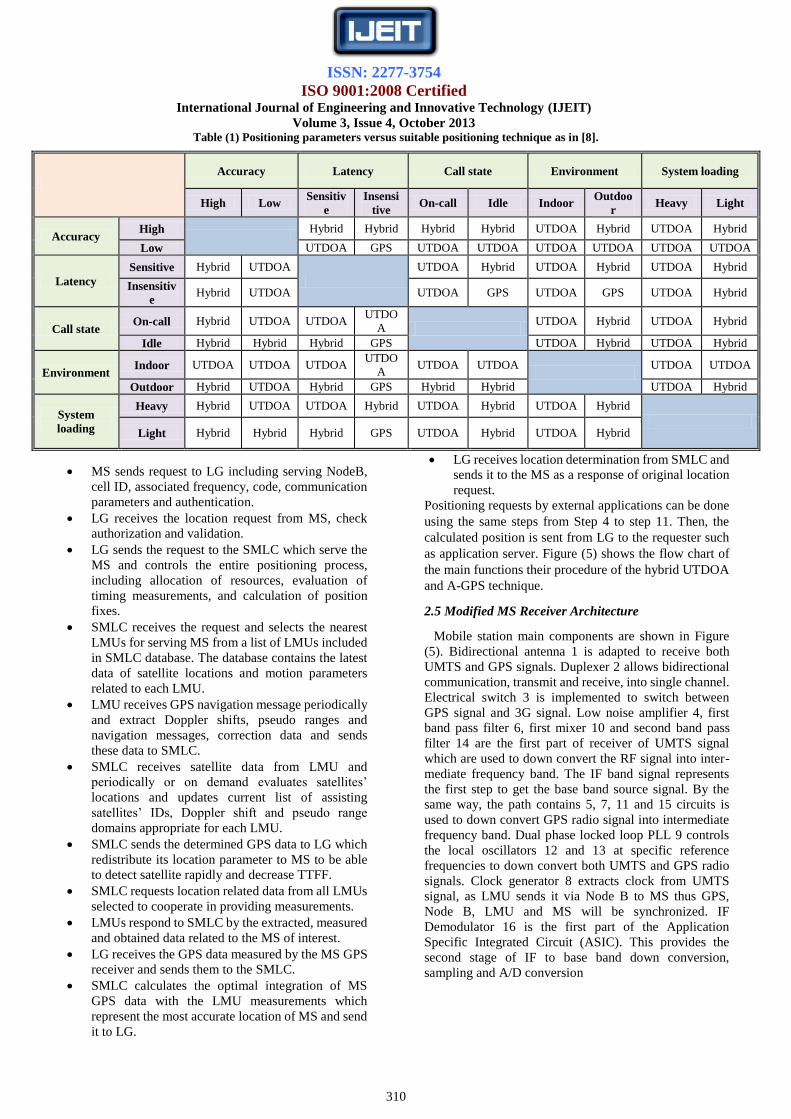
2.2 Hybrid Positioning Technique’s Parameters
Each of the already existed positioning technique has its
advantages and drawbacks. Positioning techniques are
classified according to main parameters which are presented
in Table (1) these parameters are: 1) Accuracy; 2) Latency; 3)
Call state; 4) Environment; 5) System loading.
Table (1) illustrates the used suitable positioning
technique according to the main positioning parameters. Suit-
able positioning technique such as A-GPS, stand alone GPS
or U-TDOA, is selected according to the location based
service application needed. For Examples, Mobile tracking
applications: The major property of these applications is
latency sensitive, so stand alone GPS isn’t a suitable
positioning technique. Accuracy is the second parameter in
these applications so, if application need accuracy less than
fifty meter, then hybrid technique is being used. Otherwise
U-TDOA will be the most suitable technique here.
Emergency applications: These applications require high
accuracy without time delay. Then, hybrid method is selected
in outdoor applications whereas U- TDOA will be more
precise in indoor applications. Commercial advertisements
and general information applications: Most information like
weather, traffic, advertisements are highly used in city center
and crowded regions. So, system loading is the most
positioning parameter that should be taken into
consideration. So, U-TDOA is the most suitable positioning
technique for heavy sys- tem loading.
2.3 Secure User Plane Location Protocol
In order to decrease system loading problem especially in
crowded locations and city centers secure user plane location
protocol is used instead of Radio Resource Control (RRC)
protocol which is used by UMTS mobile network as
discussed in [16]. Secure User Plane Location Protocol
(SUPL) is a network layer based on IP technology that was
developed to support Location-Based Services (LBS) for
wireless communications. SUPL employs available user
plane data bearers for transferring location information, GPS
assistance data, and for carrying positioning technology
related protocols between a SUPL Enabled Terminal (SET)
and the mobile network. This developed protocol permits
hybrid developed technology to be used in heavy loaded
networks’ systems. SUPL provides low cost and complexity
in network implementation than conventional RRC protocol
which is based on control plane.
2.4 Network Elements and Positioning Sequence
Network equipments used in mobile location
determination using hybrid technique is called Position
Determination Equipment (PDE). PDE is mainly consists of
Location Gateway (LG), Serving Mobile Location Center
(SMLC), Location Measurement Unit (LMU) and NodeB
[17]. As shown in Figure (2), plenty of network elements are
needed within hybrid positioning technique. For more
arrangement and decrease among network components the
following actions are taken into consideration.
a) Integrate each LMU into corresponding NodeB with
common processor, as shown in Figure (3). Processors are
mainly responsible for network management and provide a
centralized pool of digital signal processing resources used
in location calculation.
b) Integrate SMLC into corresponding RNC/BSC.
The procedure of detecting mobile location using hybrid
positioning technique can be logically summarized into the
following steps as indicated in the flow chart of Figure (4):
ISSN: 2277-3754
ISO 9001:2008 Certified International Journal of Engineering and Innovative Technology (IJEIT)
Volume 3, Issue 4, October 2013
310
Table (1) Positioning parameters versus suitable positioning technique as in [8].
Accuracy Latency Call state Environment System loading
High Low Sensitiv
e
Insensi
tive On-call Idle Indoor
Outdoo
r Heavy Light
Accuracy High
Hybrid Hybrid Hybrid Hybrid UTDOA Hybrid UTDOA Hybrid
Low UTDOA GPS UTDOA UTDOA UTDOA UTDOA UTDOA UTDOA
Latency
Sensitive Hybrid UTDOA
UTDOA Hybrid UTDOA Hybrid UTDOA Hybrid
Insensitiv
e Hybrid UTDOA UTDOA GPS UTDOA GPS UTDOA Hybrid
Call state On-call Hybrid UTDOA UTDOA
UTDO
A UTDOA Hybrid UTDOA Hybrid
Idle Hybrid Hybrid Hybrid GPS UTDOA Hybrid UTDOA Hybrid
Environment Indoor UTDOA UTDOA UTDOA
UTDO
A UTDOA UTDOA
UTDOA UTDOA
Outdoor Hybrid UTDOA Hybrid GPS Hybrid Hybrid UTDOA Hybrid
System
loading
Heavy Hybrid UTDOA UTDOA Hybrid UTDOA Hybrid UTDOA Hybrid
Light Hybrid Hybrid Hybrid GPS UTDOA Hybrid UTDOA Hybrid
MS sends request to LG including serving NodeB,
cell ID, associated frequency, code, communication
parameters and authentication.
LG receives the location request from MS, check
authorization and validation.
LG sends the request to the SMLC which serve the
MS and controls the entire positioning process,
including allocation of resources, evaluation of
timing measurements, and calculation of position
fixes.
SMLC receives the request and selects the nearest
LMUs for serving MS from a list of LMUs included
in SMLC database. The database contains the latest
data of satellite locations and motion parameters
related to each LMU.
LMU receives GPS navigation message periodically
and extract Doppler shifts, pseudo ranges and
navigation messages, correction data and sends
these data to SMLC.
SMLC receives satellite data from LMU and
periodically or on demand evaluates satellites’
locations and updates current list of assisting
satellites’ IDs, Doppler shift and pseudo range
domains appropriate for each LMU.
SMLC sends the determined GPS data to LG which
redistribute its location parameter to MS to be able
to detect satellite rapidly and decrease TTFF.
SMLC requests location related data from all LMUs
selected to cooperate in providing measurements.
LMUs respond to SMLC by the extracted, measured
and obtained data related to the MS of interest.
LG receives the GPS data measured by the MS GPS
receiver and sends them to the SMLC.
SMLC calculates the optimal integration of MS
GPS data with the LMU measurements which
represent the most accurate location of MS and send
it to LG.
LG receives location determination from SMLC and
sends it to the MS as a response of original location
request.
Positioning requests by external applications can be done
using the same steps from Step 4 to step 11. Then, the
calculated position is sent from LG to the requester such
as application server. Figure (5) shows the flow chart of
the main functions their procedure of the hybrid UTDOA
and A-GPS technique.
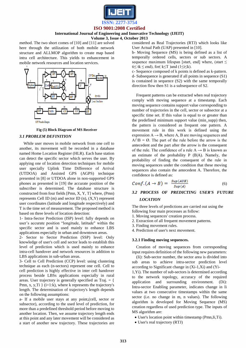
2.5 Modified MS Receiver Architecture
Mobile station main components are shown in Figure
(5). Bidirectional antenna 1 is adapted to receive both
UMTS and GPS signals. Duplexer 2 allows bidirectional
communication, transmit and receive, into single channel.
Electrical switch 3 is implemented to switch between
GPS signal and 3G signal. Low noise amplifier 4, first
band pass filter 6, first mixer 10 and second band pass
filter 14 are the first part of receiver of UMTS signal
which are used to down convert the RF signal into inter-
mediate frequency band. The IF band signal represents
the first step to get the base band source signal. By the
same way, the path contains 5, 7, 11 and 15 circuits is
used to down convert GPS radio signal into intermediate
frequency band. Dual phase locked loop PLL 9 controls
the local oscillators 12 and 13 at specific reference
frequencies to down convert both UMTS and GPS radio
signals. Clock generator 8 extracts clock from UMTS
signal, as LMU sends it via Node B to MS thus GPS,
Node B, LMU and MS will be synchronized. IF
Demodulator 16 is the first part of the Application
Specific Integrated Circuit (ASIC). This provides the
second stage of IF to base band down conversion,
sampling and A/D conversion

ISSN: 2277-3754
ISO 9001:2008 Certified International Journal of Engineering and Innovative Technology (IJEIT)
Volume 3, Issue 4, October 2013
311
Fig (2) Hybrid GPS_UTDOA network platform.
Fig (3) Common processor LMU and Nu odeB.
Second switch 17 is analogues to switch 3 and they
controlled by the same controller unit to separate
CDMA and GPS received signals at radio and
intermediate frequency bands. LMU provides GPS data
to MS via Node Bs. So, this data will be extracted by
MS using Decoder 18 to extract almanac, Doppler shift,
etc. for each of GPS satellites. The Doppler frequency
Fd that is recognized by decoder 18 is added to local
oscillator Fif to control the GPS mixer 19. This mixer is
used to convert IF signal to base band signal as the last
stage of base band signal down conversion in GPS
received path. The output of automatic gain control
AGC 21 circuit is fed to analog to digital converter A/D
22. The output of the A/D consists of the (I,Q) in phase
and quadrature components as a first and second output
digital streams respectively. The digital streams are fed
to the digital signal processor DSP 24 to produce the
required pseudo measurements. Buffer 23 is used to
store data streams in case of the rate of flow of data is
faster than that of DSP rate of processing. Pseudo
ranges are sent via MS transmitter to LMUs to calculate
the user position accurately.
2.6 Position Calculation
Location determination and measurements using hybrid
technique are classified into two main measurements.
2.6.1 Position Calculation Using U-TDOA Technique
This type of measurement is one of distance related
measures where distance is calculated through mobile network.
Measurements are based mainly on the difference between two
Times of Arrivals (TOA) for two distinct signal receptions at
least. MS is a common transmitter for signal to the distinct and
different LMUs as receiving stations positioned at locations
XR1 and XR2 respectively. TDOA technique is directly related
to the difference in TOA at different receivers. This leads to
difference in signal propagation distances (DR1, and DR2) at
receivers.
(4)
Where, c is the propagation speed of RF signal, is the
three dimensional vector coordinates of receiving position at
time of signal arrival. Determination of transmitter location
doesn't require knowledge of the TOT common epoch at which
MS signal was transmitted. Then synchronization between MS
and NodeB isn't necessary. From (4) we need at least two
NodeBs to enable U-TDOA technique to calculate the position
of mobile terminal.

ISSN: 2277-3754
ISO 9001:2008 Certified International Journal of Engineering and Innovative Technology (IJEIT)
Volume 3, Issue 4, October 2013
312
Fig (4) Flow chart of main functions and procedures of hybrid UTDOA and A-GPS technique
2.6.2 Position Calculation Using Hybrid Positioning
Technique
The optimum estimation of mobile user location depends
on the location-related information available which is
extracted from the following sources:
1) Measurement of received signal characteristics.
2) Collateral information that indicate the relative probability
of MS position.
Using Bayes probability relation the relative probability of
occurrence of measurements under condition of a priori state
condition is expressed as:
P(x/z) = [P(z/x)*P(x)]/P(z) (5)
where x is the state vector of location parameters, z is a
vector set of location measurements and P(x/z) represents
the probability of the state vector components are
evaluated for x under condition that the observations have
the values of measurement values z. Whereas P(z/x)
represents the probability that the values of vector z
would be observed under condition that the state variables
are of the values in x. p(x) is the marginal probability that
the state values of x occurred. Whereas, is the total
probability of occurrence of measured parameter values
for the observation vector z. The jointly combined
probability of independent data elements are the product
of the probability of independent data sets alone [18].
Using the proposed system, the data of various types from
diverse sources, satellite and mobile network, integrates
statistically independent data. Then, the probability
product relation is accumulated as a sum of “log
likelihood”. Sum of probabilities will introduce higher
location probability than product formula and higher
results can be obtained. This way leads to accumulation
and integration between both GPS and UTDOA
techniques to get higher positioning technique than
obtained from standalone technique. p(z).
III. FUTURE LOCATION PREDICTION OF MOBILE
SUBSCRIBER OVER MOBILE NETWORK USING
INTRA CELL MOVEMENT PATTERN ALGORITHM
Mobile network is mainly divided into clusters which
consist of cells and each cell consists of sectors. It should
be noticed that User Mobility Pattern (UMP) algorithm
that is based on sequential mining doesn't introduce intra
cell prediction [10]. In [11], movement Rule-based
Location Prediction (RLP) method has been developed
using All Movement Pattern (ALLMOP) algorithm and
based on Global Positioning System (GPS) network
platform. However, the use of GPS network platform
won’t enhance the mobile network resources allocations
and management and it requires GPS supported terminals.
In fact, the UMP algorithm is outperformed by the RLP
ISSN: 2277-3754
ISO 9001:2008 Certified International Journal of Engineering and Innovative Technology (IJEIT)
Volume 3, Issue 4, October 2013
313
method. The two short comes of [10] and [11] are solved
here through the utilization of both mobile network
structure and ALLMOP algorithm to create map based
intra cell architecture. This yields to enhancement in
mobile network resources and location services.
Fig (5) Block Diagram of MS Receiver
3.1 PROBLEM DEFINITION
While user moves in mobile network from one cell to
another, its movement will be recorded in a database
named Home Location Register (HLR). Each base station
can detect the specific sector which serves the user. By
applying one of location detection techniques for mobile
user specially Uplink Time Difference of Arrival
(UTDOA) and Assisted GPS (AGPS) technique
presented in [8] or UTDOA alone in non-supported GPS
phones as presented in [19] the accurate position of the
subscriber is determined. The database structure is
constructed from four fields [Pmn, X, Y, T] where, (Pmn)
represents Cell ID (m) and sector ID (n), (X,Y) represent
user coordinates (latitude and longitude respectively) and
T is the time set of measurement. The proposed method is
based on three levels of location detection:
1- Intra-Sector Prediction (ISP) level: fully depends on
user’s accurate position “longitude, latitude" within the
specific sector and is used mainly to enhance LBS
applications especially in urban and downtown areas.
2- Sector to Sector Prediction (SSP) level: Only
knowledge of user's cell and sector leads to establish this
level of prediction which is used mainly to enhance
intra-cell handover and network resources in addition to
LBS applications in sub-urban areas.
3- Cell to Cell Prediction (CCP) level: using clustering
technique as each (n-sectors) represent one cell. Cell to
cell prediction is highly effective in inter cell handover
process beside LBSs applications especially in rural
areas. User trajectory is generally specified as Traj. = {
Pmn, x, y,Ti } (i=1:k), where k represents the trajectory's
length. The determination of trajectory's length depends
on the following assumptions:
a- If a mobile user stays at any point,(cell, sector or
subsector), according to the used level of prediction, for
more than a predefined threshold period before moving to
another location. Then, we assume trajectory length ends
at this point and any later movement will be considered as
a start of another new trajectory. These trajectories are
considered as Real Trajectories (RTJ) which looks like
User Actual Path (UAP) presented in [10].
b- Moving Sequence (MS) is being defined as a list of
temporally ordered cells, sectors or sub sectors. A
sequence maximum lifespan [start, end] where, (start ≤
ti≤ tk ≤ end), for( k≤T )and (1≤i≤k).
c- Sequence composed of k points is defined as k-pattern.
d- Subsequence is generated if all points in sequence (S1)
is contained in sequence (S2) with the same temporally
direction flow then S1 is a subsequence of S2.
Frequent patterns can be extracted when real trajectory
comply with moving sequence at a timestamp. Each
moving sequence contains support value corresponding to
number of trajectories in the cell, sector or subsector at a
specific time set. If this value is equal to or greater than
the predefined minimum support value (min_supp) then,
the pattern is considered as frequent one pattern. A
movement rule in this work is defined using the
expression A → B, where A, B are moving sequences and
A∩B = Ø. The part of the rule before the arrow is the
antecedent and the part after the arrow is the consequent
of the rule. The confidence of a rule A → B is known as
an estimate of the probability P (B|A). Namely, the
probability of finding the consequent of the rule in
moving sequences under the condition that these moving
sequences also contain the antecedent A. Therefore, the
confidence is defined as:
(6)
3.2 PROCESS OF PREDICTING USER'S FUTURE
LOCATION
The three levels of predictions are carried out using the
following four main processes as follow:
1. Moving sequences' creation process.
2. Extraction of all frequent movement patterns.
3. Finding movement rules.
4. Prediction of user's next movement.
3.2.1 Finding moving sequences.
Creation of moving sequences from corresponding
input requires definition of the following new parameters:
(Ii): Sub-sector number, the sector area is divided into
sub areas to achieve intra-sector prediction level
according to Significant change in (Xi-1,Xi) and (Yi-
1,Yi). The number of sub-sectors is determined according
to the network topology, accuracy of the required
application and surrounding environment. (Di):
Intra-sector Enabling parameter, indicates change in Ii
values at two consecutive timestamps within the same
sector (i.e. no change in m, n values). The following
algorithm is developed for Moving Sequence (MS)
creation regardless of used prediction type. The inputs of
MS algorithm are:
User's location point within timestamp (Pmn,Ii,Ti).
User's real trajectory (RTJ)

ISSN: 2277-3754
ISO 9001:2008 Certified International Journal of Engineering and Innovative Technology (IJEIT)
Volume 3, Issue 4, October 2013
314
Maximum length of points per trajectory, Max_span
(Tmax).
The process of moving sequence's generation can be
summarized into the following steps:
1) Initialize the set of moving sequence; (MS← Φ).
2) Extract location of Mobile user.
where, (Pi ← (Pmn, Ii, Ti)
3) Initialize user's previous location (prev. loc.) ← 1.
4) Create moving sequence points according to prediction
levels shown in Figure (6) as follow:
For (i=2 ; i= max_span points ; i++) (7)
4-1) Cell to Cell prediction (CCP)
4-1-1) Disable sector and intra-sector prediction
ni, Ii → disabled
4-1-2) Create moving sequence: when there is a change
from one cell to another within two consecutive
timestamps. Then, MS consists of the previous MS in
addition to the current obtained real trajectory meets the
previous conditions.
If mi ≠ mi-1
RTJ=RTJ U (Pmi,Ti)
MS = MS U RTJ
4-1-3) Stop moving sequence at the current cell: if the
user still in the same cell from the current point Tc till
reaches Tmax. Any other movement after that is a start of
new movement.
If (mi = m i-1) , Tc<t < Tmax
MS ← stop
Fig (6) Chart of MS Algorithm with its sub-categories
4-2) Sector to Sector Prediction (SSP)
4-2-1) Disable intra-sector prediction
ni → enabled , Ii → disabled
4-2-2) Create moving sequence
If Pmni ≠ Pmni-1
RTJ=RTJ U (Pmni,Ti)
MS = MS U RTJ
4-2-3) Stop moving sequence at the current sector.
if Pmni = Pmn i-1, Tc<t <Tmax
MS ← stop
Return MS
4-3) Intra-Sector prediction (ISP)
4-3-1) Enable intra-sector number within prediction
ni → enabled , Ii → enabled
4-3-2) Create moving sequence: when there is a change
from one sub-sector to another within two
consecutive timestamps.
If (Pmni,Ii) ≠ (Pmni-1,Ii-1)
RTJ = RTJ U (Pmni , Ii , Ti )
MS = MS U RTJ
4-3-3) Stop moving sequence at the current sub-sector; if
(Pmni,Ii) = (Pmn i-1,Ii-1) , (tc<t <Tmax)
MS ← stop
Return MS
4-4) Auto-Selection of MS pattern
4-4-1) Enable Sub-sector prediction parameter (Di)
If Di = 1
4-4-2) change in sub-sector prediction level, So ISP level
is used.
Go to (4-3) → "ISP"
Else if Di = 0
4-4-3) Check sector to sector changes: if there is
movement from one sector to another within the same
main cell. Then, STS prediction is used.
If ni ≠ ni-1 , while mi = mi-1
Go to (4-2) → "STS"
Else, cell to cell prediction is the proper MS algorithm
Else Go to (4-1) → "CTC"
B. Generating frequent-1 pattern.
A dataset of real trajectories are decomposed into
groups of corresponding moving sequences. Then,
frequent-1 patterns represent dense sectors or clusters that
contain at least the minimum support points at specific
timestamp. Full trajectories on Map based are shown in
Figure (7). In ICMP cluster enabling Algorithm each
three sectors within the same cell will be considered as
one cluster. Assume that minimum support value is 2
(min_Sup≥2) then region (R1) will be considered as a
frequent one pattern at timestamp T1 where R1 contains
two points in time T1. Cells which contain lower points
than minimum support points within specific timestamp
will be considered as outliers as <R6, t3> and <R9,t5> in
Figure (7). Empty cells will be discarded as cell R7. In
ICMP cluster disabling algorithm, each cell, sector or sub
sector contains the minimum support number of points at
specific timestamp is considered frequent -1 pattern. At
any prediction method, if the same trajectory hits the
same region more than one time before it moves to the
next region, only the first hit is taken into consideration
and other hits are neglected (e.g. <(4B,t2)>) will be
discarded and moving sequence of this trajectory will be
[<(4B,t1)>,<(4C,t3)>, <(8A,t4)>] ) as shown in Figure
(7). If the user remains at the same sector till Tend,
trajectory movement is terminated at this point.
C. Generation of frequent-k patterns
Frequent-2 pattern is created by joining frequent-1
pattern with another frequent-1 pattern under condition
that both cells are neighbors and comply with the real
trajectory while moving from one cell to another.
Frequent-k pattern, where K >2 can be extracted from

ISSN: 2277-3754
ISO 9001:2008 Certified International Journal of Engineering and Innovative Technology (IJEIT)
Volume 3, Issue 4, October 2013
315
joining frequent-(k-1) pattern with frequent-1 pattern
with condition that, the two patterns related to the same
trajectory and achieve minimum support value. The
following algorithm is developed to generate frequent-k
pattern in ICMP-algorithm with clustering enabled and
disabled sub-patterns. The inputs of the algorithm are:
• moving sequence (MS).
• Minimum support (min_sup).
• Prediction patterns (CCP, SSP, ISP).
Fig (7) Full Trajectories on A Map Based on Mobile
Network Architecture as in [9]
The creation process of ICMP-frequent-k pattern
algorithm can be summarized into the following steps: 1-
Initialize the frequent movement-1 pattern with maximal
timestamp among all movement of MS.
F-1 → Φ
2- For each ti ( i=1 , i<=T, i++)
2-1) For clustering enabled sub-pattern:
2-1-1) Merge three sectors into one cell
Cell (X)← sectors (XA U XB U XC)
2-1-2) Define Region (R) as a Cell (x) with minimum
number of points at timestamp (ti) and discarding
outliers.
Region(R) ← (Cellx,Ti) ≥ minsupport
2-1-3) Discard intra-sector level (Di ←Disabled)
2-1-4) Extract (frequent-1 pattern) within specific time
(Ti). F-1←F-1 U (R,Ti) (8)
2-1-5) Initialize (Candidate-2) and (Frequent-2)
patterns.
( C-2← Φ , F-2← Φ)
2-1-6) Generate (frequent-2) patterns.
∀ F1 (Ri,Ti) ∈ F1
If(Ti>Tj), Ri,Rj neighbor cells, i≠j
Then, C-2←C-2 U < (Ri,Ti),(Rj,Tj)>
If MS [Ri→Rj] ≥ Min_Sup
Then, F-2=F-2 U <(Ri,Ti),(Rj,Tj>
2-1-7) Generate infrequent list including non- frequent
patterns to discard them from freq. k-patterns
Else, insert (infreq_list, Cand.)
2-1-8) Generate (frequent k-pattern), k>2, and update of
in frequent list as shown in [14].
For F-1 , F-(k-1) ≠1
∀ (Pi) ∈ Fk-1 , ∀ (Pj) ∈ F-1
Cand-k ←joining (Pi,Pj) ∈ MS
If Cand-k ≠ Φ (9)
Then, Ck ← Ck U Cand-k
If MS[P(k-1)→Pj] ≥Min_Sup
Fk ←F(k-1) U F1
Else, update (Infreq_list ,candk)
2-1-9) Create all Frequent patterns.
ICMP_Clustering Enabled← <F1,…,Fk>
2-2) clustering disabled sub-pattern "Sector to sector
prediction"[SSP]
2-2-1) Represent [sector to sector prediction] as a type
of clustering disabled technique.
Region(R) ← (Pmn)
2-2-2) Discard intra sector change, then apply the same
procedure from equation 3 to 4 to get all possible
frequent patterns.
Di → Disabled , Go to 3:4
ICMP_SSP ← <F-1,….,F-k)
2-3) Clustering disabled sub-pattern "Intra-Sector
prediction"[ISP]
2-3-1) Regions consist of intra sectors with minimum
support points at timestamp after discarding outliers;
Region(R) ← (Pmn,I)
2-3-2) Enable intra sector change. Then, same
procedure is applied (from equation3 to 4) to get all
possible frequent patterns.
Di → Disabled , Go to 3:4
ICMP_ISP ← <F-1,….,F-k>
3.3 Finding movement rules and next movement
prediction
Regardless of the ICMP sub pattern, the pre obtained
movement patterns are temporal joint points. For
example, movement pattern [(R4,t1),(R2,t2),(R5,t3)]
shown in Figure (2) is obtained from cluster enabling
algorithm. This pattern represent frequent-3 pattern and
has the possible movement rules:
[<(R4,t1)>→<(R2,t2),(R5,t3)>]or[<(R4,t1),(R2,t2)>→(
R5,t3)]. The confidence value of the two possibilities
should be evaluated according to equation 1. The patterns'
rules which achieve the required threshold confidence
value are selected whereas other rules are discarded. The
first assumption in the previous example has a confidence
= [Sup((R4,t1) U(R2,t2)U(R5,t3))/Sup(R4,t1)].
Sup((R4,t1) U (R2,t2) U (R5 ,t3 )) =1. Whereas, Sup
(R4,t1) = 3 points. So, confidence of the first assumption
= 33.33%. By the same way the second assumption has a
confidence = 100%. So, if the threshold confidence value
is 75% then, the second movement rule is taken into
consideration whereas, other movement rule is discarded.
By applying these movement rules on frequent-k patterns,
next movement of mobile user will be predicted
according to predefined confidence. Recursive depth
fashion is used to improve the procedure of movement
rules as being discussed in [2]. For a pattern [<(Ra,ta)>
,<(Rb,tb)> ,<(Rc,tc)>, <(Rd,td)>] we first get the
confidence for rule[<(Ra,ta)>, <(Rb,tb)>,<(Rc,tc)> →
<(Rd ,td ) >] If this rule achieved the threshold confidence
value, then [<(Ra,ta)>,<(Rb,tb)> → <(Rc,tc)>,<(Rd,td)>]

ISSN: 2277-3754
ISO 9001:2008 Certified International Journal of Engineering and Innovative Technology (IJEIT)
Volume 3, Issue 4, October 2013
316
shall be studied. Else, there is no need to check sub
patterns of this pattern as it surely will not achieve the
confidence value. ICMP rules for location prediction can
be clarified within the following algorithm. The inputs of
the ICMP rules are the Minimum Confidence (Min_conf.)
and the Frequent movement pattern (K-pattern) , K≥1.
The algorithm used in rules creation can be summarized
in the following steps:
1- Initialize the value of the prediction rule (Rule = Φ )
2- Calculate support value of k-pattern and k-1 pattern.
P-k ∈ K Pattern, Sup(Pk) ← A
P-y ∈ K-1 Pattern, Sup(Pk) ← B
3- Calculate the confidence value of the first generated
rule.
Conf.(P) = Sup(Pk) / Sup(Py) = A/B
4- Compare the calculated confidence value with
minimum confidence value adjusted to meet the
required accuracy of prediction..
Min_conf ← minimum Confidence
If Conf(P) ≥ Min_Conf
Then, Rule = Rule U <(Py)→ (Pk-y)>
Else , return rule
5- Apply recursive depth fashion in finding rules
For P(y-i), (1<i<y-1)
Conf(Pi) = Sup(Pk)/Sup(Py-i)
If Conf(Pi) ≥ Min_Conf
Then Rule=Rule U <P(y-i)→P(k-y+i)>
Else, return rule.
3.4 Simulation and results
The experimental results are obtained by performing the
synthetic datasets and estimating the performance of our
algorithm. Results are adopted according to simulation
model. The adopted model is general and flexible to be
matched with variety of understudy cases. Experiments
are executed on C# basis with a 2.39 GHZ Intel(R)
core(TM) 2 Due CPU, 1.95 GB of RAM running on
Windows XP operating system.
3.4.1 Dataset generation
To simulate the movement of the mobile user, random
data generator based on the used adopted algorithm is
developed. Table (2) includes the used parameters in
generating and processing data with default values used in
this approach. The proposed simulator is designed to
enable user to adjust the input parameters.
3.4.2 Evaluation of precision and recall
Precision and recall evaluation indicate system
performance and prediction algorithm accuracy. Using
cell to cell, sector to sector and intra-sector algorithms
with 1000 trajectories in 4x3 map, minimum support =2,
minimum confidence=80 and 100 trajectories per day, as
shown in Figure (8)
Table (2) Summary of parameters
Symbol Definition Default
values
TR Total Number of trajectories per user in the
proposed map 1000
Lmin Minimum number of points per trajectory 3
Lmax Maximum number of points per trajectory 7
TRday Number of estimated trajectories per day 100
M Map size = (mxn) cells , m=length ,
n=width 4x3
SC System capacity : No. of last trajectories
used to evaluate predictions 1000
Min_sup Minimum support value 2
Min. conf Percentage of Minimum Confidence 80
Fig (8) Precision and Recall VS Trajectories Number
3.4.3 Effect of Minimum support
Here, we study the impact of minimum support (Min
sup) values on the precision and recall percentage of
proposed algorithms. Figure (9) shows the decrement of
precision and recall values by increasing min sup value.
3.4.4 Effect of Minimum confidence
There is a direct effect of changing the percentage of
minimum confidence on the precision and recall
percentages of our proposed system. By increasing the
min conf value, the percentage of system precision also
increased due to the increment in correct predictions
compared to total number of predictions occurred.
Whereas, recall percentage decreased by increasing min
conf value as shown in Figure (10). The optimum min
conf. value =100%.

ISSN: 2277-3754
ISO 9001:2008 Certified International Journal of Engineering and Innovative Technology (IJEIT)
Volume 3, Issue 4, October 2013
317
Fig (9) Precision and Recall versus Min sup Value
3.4.5 Algorithms’ Execution time
In this section, we study the execution time proprieties
of our proposed algorithms to estimate the performance of
proposed system. Figure (11) shows execution time
measured in (m sec) as a function of total number of input
trajectories using CTC, STS and intra-sector algorithms.
The optimum parameters and working modes can be
adjusted according to the required application, user
environments and flexibility of adjusting input data
parameters.
Fig (10) Precision and Recall versus Min conf. Value.
3.4.6 ICMP Algorithm Versus other algorithms
The proposed algorithm can be applied on mobile users
at any environment as its parameters are adjustable
according to the needed accuracy and the surrounding
environment. Also, sub algorithms are adapted to suite
various location based applications in addition to
enhancement of mobile network allocation resources and
mobility management.
Fig (11) Execution Time in (msec) as a Function of Different
Trajectories Length. As indicated in Table 4, the precision of ICMP
algorithm is compared with UMP and RLP algorithms.
ICMP algorithm outperformed the two other algorithms
within range of min. support values and it matched with
the other two methods according to minimum confidence
values. The execution time of completing algorithm and
get the predicted points shows good time less than half
second in comparison with RLP method. ICMP proposed
algorithm benefits from U-TDOA technique to introduce
sector to sector and intra sector predictions. These
techniques are highly efficient in LBS applications based
on mobile networks. The optimum parameters and
working modes can be extracted depending on the
required application, user environment and flexibility of
adjusting input data parameters. The proposed algorithm
not only theoretical one but it represent practical solution
for future location prediction based on mobile network
platform at various environments.
Table (3) Precision comparison of UMP, RLP and ICMP
Min. Support
[3% - 21%]
Min. Confidence
[50 % - 100%]
Execution
Time, "sec."
UMP 0.61 – 0.93 0.6 – 0.98 0.01-0.05
RLP 0.82 – 0.99 0.82 – 0.99 20-40
ICMP 0.9 - 0.99 0.5 – 0.99 0.18 – 0.22
IV. SERVICES AND APPLICATIONS BASED ON
MOBILE USER'S LOCATION DETECTION AND
FUTURE PREDICTION
Many location based services and applications can be
regenerated according to the proposed hybrid UTDOA
and assisted GPS positioning technique. Mobile location
applications based on basic cellular phones depend on
available network platform and there is no need for
additional resources unlike smart phones which use extra
resources such as WAP, WiFi and internet applications
which consume more resources, time and they need
additional network infrastructure. On the other hand
about 28.73% of total world populations are Muslims. So,
Muslims’ applications are highly required to support
more than quarter of world's population especially when
they travel to other countries. Location based services are
one of the most growing services based on mobile
techniques which play an important role in many life

ISSN: 2277-3754
ISO 9001:2008 Certified International Journal of Engineering and Innovative Technology (IJEIT)
Volume 3, Issue 4, October 2013
318
branches. Emergency cases, safety issues, traffic
management, Muslim's applications and public
information are public type of mobile location services.
Marketing, advertisement, entertainment and tracking
applications are classified as commercial part of mobile
based services.
4.1 Public Applications
There are a lot of vital public applications in human life
as emergency, safety, traffic management, Muslims’
applications and public information applications. These
public applications serve peoples with common and
important needed data and services. Finding places like
nearest restaurant, hotel, stations, permissible food for
Muslims are most required location services. In this
section some applications are regenerated according to
the proposed system.
4.1.1 Emergency Applications
Emergency application is regarded as one of the most
important applications which are based mainly on
position detection. In many emergency cases, there is no
time to describe your location or maybe you are in the
high way and you can’t describe your position accurately.
So, using mobile detection system will solve this problem
utilizing the proposed system. The quality of emergency
applications depends on position accuracy and time
response. While mobile user requests emergency service,
mobile terminal automatically requests position using
generated system in [8]. The estimated position will be
stored in database server which will send it to emergency
server in time. By this technique, time and accuracy are
guaranteed in emergency applications.
4.1.2 Muslims' Applications
Due to traveling from one place to another, there are
many services needed by Muslims to complete their
religion activities and duties. Moreover, the numbers of
Muslim travelers for work or leisure, both domestic and
outbound, has increased tremendously. Qibla direction is
one of the most important services needed for Muslims to
pray. Prayer time which is a basic part of Muslims’ life is
based mainly on user location and it differs from one
location to another even they are in the same country.
Many researches introduce public and Muslims’
applications based on internet network which need more
time, resources and internet supported mobile devices to
obtain the required application [19], whereas the
proposed system depends on the available mobile
network and the regular mobile devices without
significant time delay. According to Figure (12), starting
with law of cosine of spherical triangle with (a, b, c) sides
of triangle and ( α, β ,ɤ) are its angles we have:
cos (b) = cos (a)*cos (c)+sin (a)*sin (c)*cos (β) (10)
Where, β= lon2 - lon1, c = /2 - lat1, a = /2 - lat2.
Substituting these values in (3) leads to:
cos (b)=cos(/2-lat2)*cos(/2 - lat1) + sin(/2-lat2)
*sin(/2-lat1)*cos(lon2-lon1) (11)
Solving for angular distance between the two points (b)
yields,
b=arcos{cos(/2-lat2)*cos(/2-lat1)+sin(/2-lat2)*sin(/
2-lat1)*cos(lon2-lon1)} (12)
The azimuth from (lat1, lon1) to (lat2, lon2) is calculated
by the law of sines:
sin(α)/sin(a)=sin(β)/sin (b)=sin(ɤ)/sin(c) (13)
Then, Sin (α) = sin (a) * sin (β) / sin (b) (14)
Consequently,
α= arcsin{sin (/2-lat2)*sin(lon2-lon1)/sin (b)} (15)
As shown in Figure (12) and by solving system of
equations from 10 to 15, the angle “α” represents the
required azimuth between the two points. So, while user
is located at point 1 and Ka’baa is located at point 2, the
calculated azimuth 'α' represents the Qibla's direction.
4.2 Commercial Applications
Due to enormous use of mobile devices all over the
world, there are many economic and commercial
applications and services based mainly on mobile
location. Many surveys predict billions of dollars in
revenues for mobile advertising [21]. Mobile network
operators are well positioned to take up a significant
percent of this advertising revenue as they negotiate deals
with content providers. Recent deals between media
companies, advertising agencies and Internet/software
industry also demonstrate significant optimism for future
growth [22]. Mobile marketing, gaming and tracking
applications represent economical part of mobile
positioning services. There are many challenges that
should be overcome to achieve good services. Quality of
Service (QoS) can be expressed in terms of location
accuracy required, response time, and reliability of
operation [23].
4.2.1 Mobile Marketing Application
In order to spread commercial advertisements to
specific users, mobile operators mainly use cell ID
method as positioning system. This method especially in
macro cells which serve big area leads to lose of time,
money and network resources as services may reach to
unexpected and undesired customers. Utilizing hybrid
uplink time difference of arrival and A-GPS method
generated in [8] the accuracy of position is refined. Using
Equations from (10) to (12) the angular distance between
the user and the target is determined.
Arc_length = radius * angular distance (16)
So the distance (d) can be obtained from:
d = Earth Radius*arcos {cos(/2-lat2)*cos(/2-lat1) +
sin(/2-lat2) * sin(/2-lat1) * cos(lon2-lon1)} (17)
Using Equations (16) and (17) the distance d is the actual
distance between the two points. According to marketing

ISSN: 2277-3754
ISO 9001:2008 Certified International Journal of Engineering and Innovative Technology (IJEIT)
Volume 3, Issue 4, October 2013
319
application, server determines the critical distance “d0”. If
d is less than or equal d0, the user will receive the
marketing service. Otherwise, mobile user isn’t the target
for this service.
4.2.2 Finding Places
One of the most useful applications used nowadays
especially in travelling abroad is finding places using
mobile phones. The nearest restaurant, mosque, church,
cinema, university and any other place can be found using
the proposed system. Data base server related to each
SMLC contains the location "longitude, latitude" of
places and is divided according to each base station.
There are two options of finding places: find nearest place
or specific place.While user requests the location of
nearest place, database server check for the place within
the user base station then the neighbor base stations.
Location "longitude, latitude" of the place is compared to
user location. The distance between user and place can be
calculated according to Equations (10),(11),(12),(15) and
(16). Also the direction of the target is determined
according to equations (13) and (14).
4.2.3 Traffic Management Application
When there are more crowds in some streets, road
administrators need to turn the way to another road or
warn cars' users. By using location prediction technique,
application server related to road administration will send
the warning messages to users whose future locations are
in the target road. The confidence threshold value is
adjusted according to the required prediction accuracy.
Also, for more precise applications when there is a need
to inform the user by distance or direction of specific
target like stop point, crowded point, etc. Equations from
(10) to (17) are used. This technique achieves good
quality of service due to good adjustable accuracy, less
time delay and save money and resources of mobile
network operators.
4.2.4 Children, Elders and Friend Tracking
Applications
In this section a new and valuable application is
generated. Using short message service mechanism,
parents can be informed whether their children lost their
path to school or didn’t reach their expected destination in
predicted time. Parent phone or any other people
responsible of children phone number are stored in
database related to child number. By applying the
proposed prediction algorithm it is possible to predict a
child (x) who should reach a specific location within time
(Tx). So if this prediction achieved then, short message is
sent to parents’ mobile phone that user (x) already reach
the predicted target. Otherwise, alarm message to parent
phone is reached that child (x) didn’t reach the predicted
target. By the same way older people are tracked by their
healthcare persons or friends. In this application, user
privacy mechanism introduced in [24] is used to control
which cellular phones is accepted to track others and
authentication behavior. All the above data should be
stored in application server which is connected to SMLC
and mobile network to achieve the tracking application
properly.
Fig (12) Circle path from point 1 to point 2 as in [12]
V. CONCLUSION AND FUTURE WORK
In this paper, hybrid UTDOA and A-GPS positioning
technique in mobile network is carried out. Network
elements' functions and its procedure for location
determination are introduced. Advanced GPS receiver
structure to achieve procedure requirements and generate
the required pseudo-ranges is implemented. The
developed technique theoretically achieved the following
advantages:
Reduction of TTFF by about 45% using assisted data
from LMU in mobile network.
High positioning accuracy than that obtained based
on standalone GPS or UTDOA.
Number of needed GPS satellites is less than that is
needed in conventional GPS according to two or
three dimension (2D/3D) applications.
The optimal positioning technique such as GPS,
U-TDOA or hybrid is obtained depending on the
positioning parameters such as accuracy, latency,
call state, environment and system loading.
Problems caused by system loading can be solved
using SUPL protocol between MS and mobile
network.
A novel future location prediction algorithm (ICMP) is
developed. ICMP algorithm is divided into three main
parts cell to cell, sector to sector and intra-sector
prediction levels, each prediction level is convenient with
specific application within certain environment. The
developed ICMP algorithm achieved the requirements of
future prediction of mobile users' location which is used
to enhance both LBS based on mobile network operators
and mobile network allocation resources, hand over
process and mobility management operations. The
proposed algorithm is mainly considered as one of the
most reliable and applicable algorithms which can be
applied on basic mobile terminals at any environments
due to its flexibility and sub algorithms which are adapted

ISSN: 2277-3754
ISO 9001:2008 Certified International Journal of Engineering and Innovative Technology (IJEIT)
Volume 3, Issue 4, October 2013
320
to suite various location based applications in addition to
enhancement of mobile network allocation resources and
mobility management. ICMP algorithm outperformed
other future location prediction algorithms as proven.
There are varieties of services and applications based on
the detection of mobile location are regenerated according
to accurate hybrid positioning technique with mobile
network system including database server. Emergency
applications, Qibla direction as one of the most important
Muslims applications and mobile marketing are based on
the proposed system. The proposed technique is
applicable on basic mobile phones without any hardware
addition. Future work implies developing more accurate
positioning methods and future location prediction
including Geographical Information System (GIS).
REFERENCES
[1] J. Borkowski, J. Lempi¨ainen, ”Practical Network-based
Techniques for Mobile Positioning in UMTS”, EURASIP
Journal on Applied Signal Processing, special issue on
Wireless Location Technologies and Applications, June
2006.
[2] J. Borkowski, J. Niemel¨a, J. Lempi¨ainen, ”Performance
of Cell ID+RTT Hybrid Positioning Method for UMTS
Radio Networks”, Proc. of 5th European Wireless Conf.,
February 2004.
[3] J. Borkowski, J. Itkonen, J. Lempi¨ainen,”Impact of UMTS
Topology Configuration on Cell ID+RTT Positioning
Accuracy”, Proc. of 15th IST Mobile Summit, June 2006.
[4] J. Borkowski, J. Niemel¨a, J. Lempi¨ainen,”Enhanced
Performance of Cell ID + RTT by Implementing Forced
Soft Handover Algorithm”, Proc. of 60th IEEE Vehicular
Technology Conf. (VTC), September 2004.
[5] J. Borkowski, J. Lempi¨ainen, ”Geometrical
Transformations as an Efficient Mean for Reducing Impact
of Multipath Propagation on Positioning Accuracy”, Proc.
of 5th IEE International Conf. on 3G Mobile
Communications Technologies, October 2004.
[6] J. Borkowski, J. Lempi¨ainen,”Novel mobile-based
positioning techniques for UMTS”, Proc. of 9th IEEE
International Symposium on Wireless Personal Multimedia
Communications (WPMC), Sept. 2006.
[7] J. Borkowski, J. Niemel¨a, J. Lempi¨ainen, ”Cellular
Location Technologies Supporting AGPS Positioning in
UMTS Networks”, Proc. of 62nd IEEE Vehicular
Technology Conf. (VTC), September 2005.
[8] M. Abo-Zahhad, Sabah M. Ahmed and M. Mourad,
"Hybrid Uplink-Time Difference of Arrival and Assisted -
GPS Positioning Technique", Int. J. Communications,
Network and System Sciences, IJCNS, Vol. 5, No. 6, pp.
303-312, June, 2012.
[9] M. Abo-Zahhad, Sabah M. Ahmed and M. Mourad,
"Future Location Prediction of Mobile Subscriber over
Mobile Network Using Intra Cell Movement Pattern
Algorithm", 1'st IEEE International Conference on
Communications, Signal Processing and their Applications
(ICCSPA’13), American university of Sharjah, UAE, Feb
12-14, 2013.
[10] Go khan Yavas, Dimitrios Katsaros, O. zgu r Ulusoy,
Yannis Manolopoulos ," A data mining approach for
location prediction in mobile environments", pp. 121-146,
2004.
[11] Thi Hong Nhan Vu , Keun Ho Ryu , Namkyu Park , " A
method for predicting future location of mobile user for
location-based services system", Computers & Industrial
Engineering vol. 57, pp. 91-105, 2009.
[12] M. Abo-Zahhad, Sabah M. Ahmed and M. Mourad, "
Services and applications based on mobile user's location
detection and prediction", ", Int. J. Communications,
Network and System Sciences, IJCNS, Vol. 6, No. 4, 2013.
[13] Alicia Rodriguez-Carrion, Carlos Garcia-Rubio, Celeste
Campo, Alberto Cort´es-Martiın, Estrella Garcia-Lozano
and Patricia Noriega-Vivas, " Study of LZ-Based Location
Prediction and Its Application to Transportation
Recommender Systems", Sensors Journal, 4 June 2012.
[14] Axel Kupper," Location based services fundamentals and
operation", John Wiley & Sons Ltd, The Atrium, Southern
Gate, Chichester, West Sussex PO19 8SQ, England , 2005.
[15] Frank van Diggelen, "A-GPS: Assisted GPS, GNSS, and
SBAS", ISBN-13: 978-1-59693-374-3 2009.
[16] 3GPP TS 25.433, “UTRAN Iub Interface Node B
Application Part (NBAP) Signaling,” Version 7.6.0,
Release 7.
[17] F. van Diggelen, “A-GPS: Assisted GPS, GNSS, and
SBAS,” Library of Congress Cataloging-in-Publication
Data, 2009.
[18] R. J. Anderson and J. E. Maloney, “TDOA/GPS Hybrid
Wireless Location System,” US Patent No. US7925274-
B2, 2011.
[19] " TSG-RAN Meeting #24 RP-040164", Seoul, Korea 2-4
June 2004.
[20] Subhankar Dhar, Upkar Varshney, “Challenges and
Business Models for Mobile Location-based Services and
Advertising”, communications of the ACM, vol. 54, No. 5,
pp.121-128, May 2011.
[21] Louise Barkuus, and Anind Dey, “Location-Based
Services for Mobile Telephony: a Study of Users’ Privacy
Concerns”, 9TH IFIP TC13 International Conference on
Human-Computer Interaction, July, 2003.
AUTHOR’S PROFILE
Prof. Mohammed Abo-Zahhad (SIEEEM’00) received his B.S.E.E. and
M.S.E.E degrees in electrical engineering in 1979 and 1983 respectively, both from
Assiut University, Egypt. In 1988, he
received Ph. D. degree from the University of Kent at Canterbury, UK
and Assiut University (channel system).
From August 2006 till July 2012, he has been a vice-dean for graduated studies,
Faculty of Engineering, Assiut
University. Moreover, he is a credited reviewer at the Egyptian National
Authority for Quality Assurance and
Accreditation of Education (NAQAAE) since March 2011.
His research interests include switched-capacitor, optical and digital filters, biomedical and genomic signal processing, speech processing,

ISSN: 2277-3754
ISO 9001:2008 Certified International Journal of Engineering and Innovative Technology (IJEIT)
Volume 3, Issue 4, October 2013
321
data compression, wavelet-transforms, genetic algorithms, immune
algorithms, wireless sensor networks and electronic systems. He has
published four books and more than 100 papers in national and international journals and conferences in the above fields. Professor
Abo-Zahhad is currently a Professor of Electronics and Communication
Engineering, since Jan.1999. Also, he is the director of AU Management Information System (MIS) center since August 2006. He is a member of
the European Society of Circuit Theory and Applications, 1998 and a
senior IEEE member, 2000.
Prof. Sabah M. Ahmed received her
B.S.E.E. and M.S.E.E degrees in
electrical engineering in 1979 (excellent with honors) and 1983 respectively, both
from Assiut University , Egypt . In 1992, she received Ph. D. degree from the
Technical University of Budapest,
Hungary. Her research interests include speech processing, biomedical and
genomic signal processing, data
compression, wavelet-transforms, genetic algorithms, and immune
algorithms. She has published more than
55 papers in national and international journals and conferences in the above
fields.
Professor Sabah is currently a Professor of Electronics and Communication Engineering, since Feb. 2009. Also, she is the director
of Faculty of Engineering ICDL center, Assiut University and the
manager of Assiut University communication and information technology training center.
Engineer Mohamed Mourad
A.Rahman received his B.S.E.E. and
degree in electrical and Electronics engineering in 2008 from Assiut
University , Egypt . Worked as BSS
Telecom Engineer in Alkan Network Co. " operation for Vodafone and Etisalat
mobile network operators" for 3 years. In
2011, Worked as Demonstrator in El-Asher University (EAU). From 2012,
working as demonstrator in Nahda
University (NUB), Egypt. His research interests include mobile communication,
Wireless communication and signal
processing. he has published 4 papers in national and international journals and
conferences in the above fields.