newmarket and weavers’ square an margadh nua agus cearnóg
TRANSCRIPT

1
Newmarket and Weavers’ SquareAn Margadh Nua agus Cearnóg na bhFíodóirí
A pattern of past and presentHistorically, Newmarket and Weavers’
Square formed an area of patchwork
development. Urban row dwellings,
interspersed with open industrial spaces,
housed a mix of native inhabitants and
immigrant newcomers. Much of the sur-
rounding street plan, which dates from
the late seventeenth century, was once
central to Dublin’s clothworking, leather
tanning and brewing/malting industries.
This urban landscape still holds echoes
of the enterprising spirit of its early
building and industrial ventures.
Medieval landscapeWhen medieval ‘Dubline’ expanded
beyond its walls, suburban, monastic
and industrial development grew along
the major thoroughfares. Three gateways
were built outside the city walls, along
the Coombe, to aid defence and the reg-
ulation of traffic and commerce. An area
of high ground by the Coombe (derived
from com or ‘valley’) extended from what
is now Ardee Street to New Row, south to
Mill Street and was bordered by the
Commons Water, the Abbey Stream and
the River Poddle. This area eventually
became the site of Weavers’ Square,
Newmarket and St Luke’s Church.
Prior to this development, the site served
as farmland, part of a hinterland which
helped to feed Dublin’s inhabitants. A
medieval traveller arriving to Dublin
Close up of John Speed’s map of Dublin, 1610, showing the extra-mural gate and development alongthe Coombe in the suburb known as the Liberties (circled)

from the direction of Crumlin to the
southwest would have proceeded along
the ancient Slí Dhála (‘highway of the
assemblies’, now Cork Street). Following
the route flanked by agricultural fields
and abbey millstreams, he would have
proceeded in the direction of Waxamay’s
Gate (near the west end of the Coombe
at Ardee Street) along the Upper
Coombe and across the Commons
Water (near Ash Street). He would have
walked through Coombe Gate (at what is
now the junction with Hanover Street)
and then passed St Francis’ Gate on his
left where Francis Street now joins Dean
Street. From there he would have turned
left and continued up St Patrick’s Street
into the city, passing first through St
Patrick’s Gate and then through the city
wall at St Nicholas’ Gate.
Except for old boundaries and rights of
way, none of the medieval landscape of
Newmarket and Weavers’ Square sur-
vives above ground. This may be due, in
part, to the intermittent ravages of war-
fare. An inventory of 1643-1644 lists
many houses on the Coombe (21),
Pimlico (23) and elsewhere as having
been abandoned due to proximity to the
outer wartime fortifications of Dublin.
These fortifications, well outside the
medieval city walls, extended from
beyond New Street via Roper’s Rest and
Crooked Staff (Ardee Street) to Pimlico
and James Street. The disappearance of
much of the medieval landscape owes
more, however, to the extraordinary
development of the area from the late
seventeenth century. Apart from the evi-
dence of medieval water engineering
found at a variety of locations, excava-
tions in Newmarket and nearby indicate
that the area remained predominantly
rural until the late 1600s.
Archaeologists have found evidence of
medieval leather tanning off Fumbally
2
Dr Howard Clarke’s ‘Reconstructed Map of Gaelic Dublin, 6th-9th Century’ (Reproduced courtesy ofDr Clarke and the National Library of Ireland)

Lane and New Street where wood-lined
soaking pits and elaborate ditch systems
have been unearthed. ‘Blackpitts’ is like-
ly to refer to this smelly, hide-processing
activity and not to mass graves of Black
Plague victims as has sometimes been
suggested. At the corner of Ardee Street
and the Coombe Bypass, the medieval
millpond on the Commons Water, most-
ly silted up by the seventeenth century,
was unearthed.
The Abbey and the EarlThe patchwork built environment at
Newmarket and Weavers’ Square arose as
a consequence of the peculiar adminis-
trative history of the Liberty of Donore.
Like the Liberty of Thomas Court north
of the Coombe, Donore appears to have
originated as a district held by the Abbey
of St Thomas from the twelfth century.
Following Henry VIII’s dissolution of the
monasteries in the mid-sixteenth centu-
ry, these lands were acquired by William
Brabazon, ancestor of the Earls of Meath,
and became known as the ‘Meath
Liberties’. This administrative history
meant that the Abbey, and later the
Brabazons, enjoyed unusual access and
rights to water. They defended these
rights vigorously until the abolition of
the Brabazons’ manor court in 1859.
Medieval water managementThe canons of St Thomas were responsi-
ble for extensive engineering works
which routed water through abbey lands
in order to supply their mills. From as
early as 1185, these works may have
diverted water from the River Dodder to
Kimmage, where it joined the River
Poddle. At Kimmage, a stone tongue,
known locally as the ‘stone boat’, and
built under the direction of the Abbey,
divided the water by a ratio of 2:1.
3
Close up of Bernard de Gomme’s map, 1673, showing St Patrick’s Cathedral (centre). The area whichlater became Newmarket is shown as fields, bounded to the north by the Coombe (show as astream), to the west by Crooked Staff (later Ardee Street) and New Row to the east
St. Patrick’s Gate

An artificial channel, the City
Watercourse, took one-third of the water
north-west toward Dolphin’s Barn. Close
to what is now Basin Lane, the channel
continued east along the south side of
James Street, through Thomas Street and
on into the city. This circuitous route
may have been necessary in order to skirt
the lands of the Abbey and to provide
sufficient fall for the water to reach the
elevation of the city conduit in High
Street.
The remaining two-thirds of the Dodder/
Poddle water, flowing north from
Tonguefield, followed the original course
of the Poddle as far as Harold’s Cross.
Nearby, the first of St Thomas’ three
mills, the Woodmylle (rented from the
Prior of the Holy Trinity despite its loca-
tion on abbey lands) served the southern
abbey precincts. From this point, what
became known as the Abbey Stream (a
term not used in Meath Liberties’ leases)
was channelled northwest to serve the
western precincts of St Thomas. Its route
deviated from the Poddle’s original
course, flowing towards the reputed site
of Donore Castle, along what is now
Donore Avenue. This horseshoe-shaped
stream continued north-east across
Dolphin’s Barn Lane, through ‘the pipes
and the ridges’ grounds nearby to the
City Watercourse (adjacent to what later
became Marrowbone Lane). Flowing
along the walls of the Abbey itself, the
Abbey Stream powered the Thomas
Court Mill. From there it turned south
once more along what is now Tripoli,
Pimlico and Ardee Street, across
Newmarket, and on to feed the millpond
of the Double Mills at what became
Warrenmount on Mill Street. Near
Blackpitts, it rejoined the original, natu-
ral watercourse of the Poddle, crossed
behind what is now New Row to a wide,
4
Charter of the Liberties, 1192
Millstones found near the medieval millpondon Cork St (F. Myles)

fordable spot – Cross Poddle – at the end
of Patrick Street.
Less is understood about the Commons
Water, which rose in Drimnagh and sup-
plied a millpond alongside the Slí Dhála.
The presence of this pond in boggy
ground may help explain the Cork
Street/Ardee Street/Upper Coombe dog-
leg along that ancient route. Originally a
boundary stream, the extent of engineer-
ing of the Commons Water remains
uncertain. It is known, however, that
between the millpond and Ardee Street it
crossed beneath the Abbey Stream, con-
tinued along the north side of the
Coombe to what is now Ash Street, and
crossed the thoroughfare to continue
along the south edge of the Lower
Coombe. It merged with the Abbey
Stream at Cross Poddle. Another engi-
neered watercourse, the Tenters Water,
diverted part of the Abbey Stream east-
wards (along what is now Brown Street
South and Oscar Square) to rejoin it
again just upstream from the Double
Mills millpond.
Most of these watercourses – and others
for which no written records remain –
survive beneath our streets. Some are
silted-up, u-shaped channels. In places,
earth and stone dykes have been uncov-
ered alongside the ancient channels, fre-
quently with nearby, later culverts which
have taken over the same function. The
millstream near Warrenmount is one
well-known example of a watercourse
that remained open into the twentieth
century. An overall picture of the loca-
tions, origins and uses of these water-
courses may be achieved by combining
5
Thirteenth to eighteenth-century tanning pits on New St South (A. Giacometti)

the results of a large number of (mostly
small-scale) archaeological digs in the
neighbourhood, although our under-
standing of this aspect of Dublin’s histo-
ry is far from complete.
To some extent the watercourse pattern
is preserved above ground with the lay-
out of modern streets. Although
Newmarket and Weavers’ Square are
measured, planned layouts of the late
seventeenth century (see below), nearby
streets such as Mill Street, Marrowbone
Lane and Pimlico/Ardee Street seem to
have originated as rights-of-way along
6
(Above) Seventeenth-century shoe from a tanning pit on New St South (A. Giacometti)(Below) Brooking’s 1728 Map of Dublin showing section with Newmarket and Weavers’ Square(north is down). Also shown are the Coombe, Pimlico and Crooked Staff (now Ardee Street)

the engineered waterworks and plough
headlands of the Abbey’s old precincts.
The extraordinary water rights enjoyed
by both the Abbey of St Thomas and the
Brabazons were perhaps the single most
important factor in the growth of indus-
try in the Newmarket and Weavers’
Square area. The trades which gained
footholds required access to water, or
were closely related to those which did.
These included milling, malting, brew-
ing, distilling, tanning, and later textile
production and cloth dyeing.
7
Eighteenth-century malthouse on Ardee St (F. Myles)

The seventeenth-century building boomIn Restoration Dublin (c.1660–1685)
improvement-minded landlords and
investors began to launch new develop-
ment ventures across the city. The popu-
lation of the capital expanded and con-
tinued to grow into the eighteenth cen-
tury with many immigrants settling in
the Meath Liberties. Most of the streets
and property plots around Newmarket
and Weavers’ Square were conceived and
laid out in the late 1600s and early
1700s. Surviving street names reflect
this: Earl Street, Meath Street, Brabazon
Row and Chamber Street are all names
referring to the Brabazon family. The
Meath Liberties appealed to the new
breed of entrepreneur for several rea-
sons: for the availability of undeveloped
land and agricultural raw materials; for
the proximity to the city without
Corporation regulations; and for the
plentiful supply of water.
In 1674, a royal patent was obtained for
a twice-weekly agricultural market, and
in 1675, William, 3rd Earl of Meath,
sought its implementation. A map of the
‘New intended Market of Donour’ illus-
trates the planned 21-foot wide alleys
and lanes, 31-foot wide main streets and
a marketplace modelled on Smithfield
across the Liffey. A market house with a
8
Map of the ‘New intended Market of Donour’, 1670s (P. Walsh, courtesy of the Rt Hon. Anthony, late14th Earl of Meath and the Meath family).
NewmarketAn Margadh Nua

15-foot wide passage surrounding it was
planned for the south end of Brabazon
Row. ‘Sheep Penns’ were to line both
sides of Ward’s Hill. After 1676, it
became possible to grant longer-term
leaseholds which were more attractive to
‘middlemen’ investors. The first develop-
ment plots in Newmarket date from
within a decade or so after this time – yet
take-up was slow.
Early leases usually stipulated that plots
should be built on within seven years,
yet despite this clause archaeology indi-
cates that the pace of development var-
ied. Findings also indicate that most arti-
sans both lived and plied their trade in
the same building, or on the same prop-
erty. Many occupations requiring out-
door space were noisome trades dealing
in animal by-products related to the new
market. Tanyards, knackeries and ren-
derers’ yards stood cheek by jowl with
smaller-scale skinners, glovers, glue-
makers as well as cloth workers and
brewers/malters. Along with the yards,
large tenter fields, in which cloth or
skins were stretched to dry and cure on
outdoor wooden frames (hence the
expression ‘on tenterhooks’), provided
large open spaces within the new urban
landscape. Such tenter fields were pres-
ent south of Chamber Street and
Weavers’ Square (near modern-day
9
In situ remains of a barrel used as a c. 1700 water cistern on John Meares’ premises (W.O. Frazer)

Oscar Square and Thomas Street) and off
Skinner’s Alley (Newmarket Street,
beneath where St Luke’s is now). ‘The
bleaching field’ (along the present south
end of Clarence Mangan Road) was
another large open space used for the
processing of textiles.
The Newmarket development (with oth-
ers in the Meath Liberties) was planned
and project-managed by interested mid-
dlemen. These included tanners, George
and James Edkins; clothiers, Matthew
Kane and his sons; brewer, Arthur
Emerson; his son-in-law Bernard Browne
who was a glover and Oliver Cheney, an
agent of the Earl. Water from the Abbey
Stream supplied cisterns in the yards of
individual properties via a sophisticated
network of ‘Bored Pipes’ of ‘oak and dale’
[deal]. The amount of water (cistern
size, pipe gauge) was based on the per-
ceived needs of each household/busi-
ness, and the twice-yearly rates, payable
to the Earl, were assessed accordingly.
The connection between water supplied
and the needs of artisans – as assessed by
middlemen developers – demonstrates
(and archaeology has confirmed) that
frequently plots were subdivided, houses
were built and water was provided
according to the specifications of intend-
ed inhabitants. In certain instances, the
inhabitants were themselves middlemen,
but there were also craftspeople further
down the social ladder who seldom show
up in written records.
10
Newmarket St: excavation of the stone-lined cistern (front) behind carpenter Peter Wainwright’s c.1700 Dutch Billy (off to right), with dyer John Meares’ adjacent c. 1700 Dutch Billy and back yard(back) and the cistern in Faithful Tate’s Newmarket garden (c. 1684; back left) (W.O. Frazer)
Weavers’ Square and Chamber Street
took off as ventures in the 1690s when,
as the former place name suggests, they
became central to the clothworking
industry. The organisation of early textile
production ran along similar lines to the
operation of the modern global clothing
industry in the Third World. The master
artisans, who made most of the profit,
farmed out piecemeal work (initially
wool and later silk) to journeyman
weavers, who laboured with the aid of
wives, children and apprentices in their
own homes. With the onset of industri-
alisation in the eighteenth century, large
mills employing many textile workers
sprang up around, and in place of, earli-
er domestic houses. The Weavers’ Hall,
in existence by 1682 and rebuilt on the
north side of the Coombe in 1745 (com-
plete with a gilded statue of George II
over its door), is testament to the impor-
tance of the cloth trade in the area dur-
ing this period.
British legislation relating to trade was
invariably protectionist. The growth in
Irish woollen goods followed prohibitive
duties on the export of live sheep, but
this was damaged by the Woollen Act of
1699. The Act forbade the export of Irish
woollens overseas and imposed duties
11
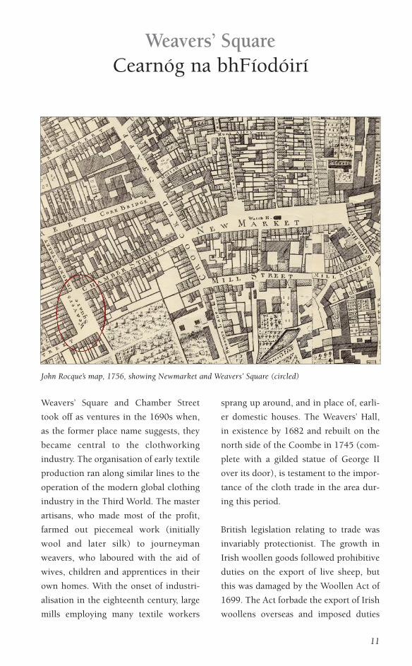
Weavers’ SquareCearnóg na bhFíodóirí
John Rocque’s map, 1756, showing Newmarket and Weavers’ Square (circled)

on exports to England. Irish manufac-
ture concentrated on ‘frieze’, a lower
quality woollen cloth not widely pro-
duced elsewhere. Even during boom
periods, resources were scant for many
cloth workers and their families. Times
of recession, such as the slump of 1720
to 1721 in which tariffs against home-
spuns, native broadcloths and cheap,
subsidised imports silenced thousands of
looms, were often connected with out-
breaks of disease and famine. (That of
the 1720s prompted Jonathan Swift’s
satire A Modest Proposal.) During lean
years, householders kept a few animals
in the yard to provide wool and dairy
both for their own use and for sale in
nearby Newmarket. Archaeology sug-
gests that cloth workers on Newmarket
Street raised sheep and processed wool
as a sideline to their main employment.
Brick row houses and Dutch Billys
The architecture of weavers’ homes on
Chamber Street and Weavers’ Square
reflected their working arrangements. In
Chamber Street, narrow, two- and three-
storey, plain gable-fronted, brick row
12
Dutch Billys with the tower of St Patrick’s Cathedral in the background, New Row, 1880s (RSAI)
houses with roomy well-lit garrets were
occupied by journeyman weavers, who
required indoor space to work their
looms, and by other artisans. Buildings
on Weavers’ Square tended to be more
spacious, as were other occasional town-
houses in the neighbourhood which
were built for the socially aspirant mas-
ter artisans, merchants and agents of the
Earl. The area has come to be associated
with Huguenot weavers, but others also
worked in weaving and in related trades
such as spinning, bleaching/fulling, dye-
ing.
Late seventeenth- and early eighteenth-
century Dutch Billys (named after
William III) were also characteristic of
the area. This Anglo-Dutch architecture
is commonly attributed to Dutch and
Flemish immigrants fleeing the
Revocation of the Edict of Nantes
(1685), yet the building of these houses
in Dublin predates 1685. This suggests
some earlier seventeenth-century archi-
tectural influence from immigrants from
the Low Countries. A distinctive feature
of the Dutch Billy was the roof-ridge per-
pendicular to the street. Sometimes, a
cross-ridge was introduced to give four
gables and extra space in the garrets. In
the most characteristic houses, the front
gables of steep roofs were hidden by
curved quadrants sweeping up to flat
curved or triangular pediments with
heavily moulded string-courses on the
front elevation delineating storeys. The
houses were built of brick, often on
stone foundations, and stood in continu-
ous rows. Corner fireplaces frequently
allowed two houses to share a single,
bulky chimney stack. Although Dutch
Billys on Newmarket and Weavers’
Square were less ostentatious than their
counterparts in more prosperous neigh-
bourhoods, they still provide insight into
the lives of their inhabitants. These hum-
ble structures often had only a ground
floor, first floor and garret, with no base-
ment. References to cellars in Meath
Liberties leases are rare. Some excavated
Dutch Billys on Skinner’s Alley
13
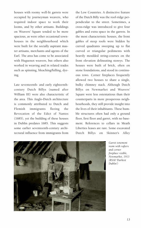
Garret tenementroom with raftersand cornerfireplace visible,Newmarket, 1913(RSAI ‘DarkestDublin’)

(Newmarket Street) show evidence of
crawlspace ‘underfloor’ cellars which
seem to have served as cool storage for
dairy products destined for market. A
typical house had a ‘two up, two down’
floor plan in which each room had a cor-
ner fireplace on the chimney stack, and a
large garret.
The subdivision of buildings into tene-
ments commenced in the late seven-
teenth century and was widespread by
the end of the eighteenth century. A four-
room-plus-garret Dutch Billy might have
been split into as many as five or six
rooms, each let separately and many
with their own exit to a street, yard or
alley.
‘that thieves’ kitchen’
Beginning with the late seventeenth-cen-
tury development of Newmarket, many
of the leases were extended from a 41-
year maximum to 61 years, as investors
sought longer contracts. ‘Lives renew-
able’, wherein the heirs of middlemen
tenants were able to renew leases,
became one of the predominant means of
conveyance in the Meath Liberties.
However, Catholic tenants were exclud-
ed from this and, after the Forfeiture leg-
islation of 1703, were not permitted
14
Dutch Billys on Sweeney’s Lane, c. 1900 (RSAI)

leaseholds of more than 31 years. Only
one Catholic middleman, Thomas
Ashton – a seedsman married to a
Protestant – was granted a lease of ‘lives
renewable’ by the Earl in 1688. The lease
was for a property on the south-west side
of Newmarket that fronted onto Crooked
Staff (Ardee Street) and Mill Street.
Ashton sublet part of the property to
Henry Poulter, son of a brewer of New
Row who, in turn, had subtenants of his
own.
From as early as 1710, more prosperous
residents had begun to move to rural
locations in County Dublin and beyond,
although many maintained business
premises and other property in the
Meath Liberties. As the eighteenth cen-
tury progressed, fewer people worked
their trades in their own homes or yards.
All major businesses in the area – tex-
tiles, tanning and brewing/malting –
became more industrialised, and control
over them was concentrated in fewer,
more powerful hands.
The subdivision of properties into short-
term tenancies became extensive.
Buildings, originally constructed to
house families, were split into tenements
in which individual rooms were rented
out by the week. Residents continued to
be employed in the large-scale industries
centred in the area, and ‘downturns’ in
such industries, with their wage-reduc-
tions and mass layoffs, precipitated star-
vation and outbreaks of contagious dis-
ease. Rents for tenement rooms in the
Meath Liberties were particularly low,
15
Eighteenth-century porter house brewery and malt house on Ardee St (F. Myles)

16
and this attracted such large numbers of
poor inhabitants that the area became
known as ‘that thieves’ kitchen’ in some
contemporary leases. The 1798 census
tallied 7,241 residents of the parish of St
Luke, of which 6,839 (94.4%) were
‘lower class’. (More than half of these
were female: 3,990 or 55.1%.) In James
Whitelaw’s 1805 survey which was based
on the 1798 census, 454 houses in St
Luke’s were inhabited, with 41 ‘waste’
(abandoned or derelict), which yielded a
crowded average of 15-16 people per
‘house’. Archaeological findings show
the effects of subdivision and neglect on
older Dutch Billys and similar buildings.
Evidence has been uncovered for the fail-
ure of water pipes, the blocking of door-
ways between rooms and the addition of
rickety external stairwells. By the end of
the eighteenth century, widespread per-
petual ‘lives renewable’ leases, fixed
rents, multiple layers of subtenants and
inactive, profiteering landlords, had all
contributed to the decline of the area.
A consequence of the slum divisions
which became characteristic of the
Newmarket and Weavers’ Square area is
that many of the original structures in
the neighbourhood survived, subdivided
and altered, into the nineteenth and
twentieth centuries. Even today, a num-
ber of structures, with significantly
altered street facades, still contain build-
ing fabric from the late 1600s to early
Gable buildings on Chamber St, 1913 (RSAI ‘Darkest Dublin’)

1700s. The absence of basements in
many buildings means that, in many
cases, the archaeology of the site still lies
buried.
Immigration
The number of Dubliners expanded
hugely over the course of the seven-
teenth and eighteenth centuries, despite
periods of war and disease. The popula-
tion of the city grew from an estimated
5,000 to 10,000+ (1% of the total popu-
lation of Ireland) in 1600, to 40,000 to
45,000 (9%) by 1664-1669. By the
1700s, Dublin was second only to
London in size, with a population of
60,000 to 75,000. By 1800, 180,000 peo-
ple resided in the city. Scholars have doc-
umented the huge influx of industrial
workers into suburbs like Crumlin and
Kilmainham where the number of adult
residents grew by 60% to 80% in the
decade after 1650. The Newmarket and
Weavers’ Square area also experienced an
extraordinary influx of skilled artisans
before and after 1700.
An ‘Act to Encourage Protestant
Strangers to Settle in Ireland’ was passed
in 1662, but as early as 1630 there are
records of continental Huguenots set-
tling in Ireland. As local folklore sug-
gests, Huguenots settled in the
Newmarket and Weavers’ Square area
from the late seventeenth century, where
they contributed substantially to the
development of the textile industry.
Significant Dutch immigration into the
area was already underway by the middle
of the 1600s, due, in part, to intensive
17
Cottages on Blackpitts, 1913 (RSAI ‘Darkest Dublin’)

Dutch involvement in shipping and
cloth manufacture. Many of the conti-
nental immigrants, fleeing religious per-
secution, arrived via England, notably
Bristol and London’s East End. They
were accompanied by an influx of
English settlers, including many reli-
gious nonconformists. By the 1690s,
many of these settlers were also cloth
workers who hailed from England’s West
Country.
The area seems to have been mostly
Protestant in the seventeenth and eigh-
teenth centuries, to the extent that it had
its own ‘animal gang’ of bigoted street
thugs – many of them apprentice
weavers – called the ‘Liberty Boys’.
However, a growing Catholic minority
was also resident by the mid-eighteenth
century. In 1718, Anthony Dopping
summarised the denominational affilia-
tion of residents in the parish of St Luke’s
(and probably underestimated both
Catholics and dissenting Protestants) as
follows: ‘Conformists 2,438 [including
conformist Huguenots]; Dissenters 823;
Papists 1,106’. Institutional discrimina-
tion against Irish Catholics in, for exam-
ple, the terms of leases and membership
of artisan guilds has made them less vis-
ible in other surviving historical docu-
ments. Nevertheless, the large number of
‘Popish’ schools recorded in 1731 indi-
cates the size of the Catholic part of the
population in the Meath Liberties. Four
such schools were identified in the
parish of St Catherine’s (Thomas Court):
in Earl Street, Pimlico, Poole Street and
Braithwaite Street. In the parish of St
Luke’s (Donore), six schools were listed
(five run by women): two were in New
Row and one each in Mill Street, the
Coombe, Fordham’s Alley (now Coombe
Court) and Truck Street (now Brabazon
Street). No mass houses were recorded in
the Meath Liberties at the time, perhaps
because of the proximity of ‘St Francis’
Chappel’ in Francis Street.
The high proportion of nonconformist
Protestants in the area, particularly
among the weavers and tanners, meant
that a number of meeting houses for dif-
ferent groups of dissenters were also
scattered throughout the neighbour-
hood. One off Newmarket Street (now
demolished, but with foundations
beneath the present grounds of St Luke’s)
was the site of the ‘battle of Skinners
Alley’, a fracas between independent
Baptists, Moravians and Methodists
which resulted in a slanderous pamphlet
18
The Weavers’ Hall, demolished in 1956

war in 1747. (Some of the pamphlets still
survive.) John Wesley preached in this
meeting house between 1748 and 1752.
The church of St Luke the Evangelist
In response to overcrowding associated
with an influx of new parishioners, the
parish of St Nicholas Without (‘without’
meaning outside the city walls) was
divided in 1707 and the new parish of St
Luke was formed. Prior to this, services
had been held in the north transept of St
Patrick’s Cathedral. The church of St
Luke was built in 1715-1716 in a plain,
rectangular form with a gallery to a plan
typical of many new Anglican churches
of the time. Originally, the west end of
the church had a double bellcote. For a
time after 1789, parishioners of St
Nicholas Without removed services to St
Luke’s where a new gallery was built to
accommodate them. Shortly afterwards,
they returned to the Lady Chapel in St
Patrick’s until 1861 when they amalga-
mated finally with the parish of St Luke.
Within the church grounds, adjacent to
the Coombe entrance, a school for poor
19
1818 watercolour painting depicting St Luke’s Church with graveyard in front (National Gallery ofIreland)
Detail from the 1886/7 OS map showing theformer parochial school of St Luke’s Churchwhich became the Widows Alms House

boys was established in 1810. In 1862,
the building was converted into the
Widows Alms House. (The advertise-
ment for the annual St Luke’s charity ser-
mon in 1825 called it ‘the poorest parish
in Dublin’.) A new access to St Luke’s
from Newmarket was open in 1884, to
replace the lane from Skinner’s Alley, at
that time reported to be ‘choked with
stagnant and putrefactive matter’. Today,
the remaining precinct of St Luke’s sur-
vives as an oasis of green space in the
neighbourhood. The protected church
and grounds are undergoing renovation.
Brewing, tanning and other early
industry
Brewing and tanning have a long history
in the Meath Liberties, dating back to
medieval times. Before the late seven-
teenth-century development of the
Newmarket and Weavers’ Square area,
these industrial activities clustered
around the old watercourses of the Abbey
of St Thomas in, for example, the
Coombe and near Blackpitts, where tan-
ning pits date from as early as the 1300s.
Brewers, such as Hugh Leeson (twice
Mayor of Dublin, in 1651-1652 and
1655-1656) and Richard Gustard, had
businesses in the Coombe from the mid-
1600s. But with the extensive under-
ground wooden water pipe systems built
from the 1680s onwards, the number of
such businesses grew. Another brewer,
Captain John Chamberlain (he sublet the
‘Gateshead’ maltings and brewery at the
east end of Newmarket) and James
Edkins (a tanner and middleman devel-
oper of Newmarket and Mill Street), were
involved in the construction of these
underground pipe systems. Tanyards,
breweries, malthouses, and related arti-
20
Pre-1975 view from the gatesof St Luke’s with the WidowsAlms House on the left(Representative Church BodyLibrary)
The Widows Alms House during thedevelopment of the surrounding site

sans such as skinners, cobblers, glovers,
carpenters and coopers, set up through-
out the neighbourhood, wherever water
could be piped. Even though prior to the
mid-eighteenth century hops were rare,
and light, pale ale was the usual tipple,
hops have been found in archaeological
deposits from c.1700 at the east end of
Newmarket, adjacent to the Gateshead
maltings. Part of another 1720s brewery,
which was fed by a wooden water pipe,
has been excavated on Ardee Street. In
the 1760s to 1770s, a Mr Farrell operated
a brewery at Blackpitts where the first
Dublin porter may have been brewed.
John Purser, an English brewer employed
by Farrell, left to work for Arthur
Guinness in the 1780s.
Seventeenth-century artisan activities
were predominantly small-scale, house-
hold enterprises – the equivalent of
21
c. 1700 pipe-fedcistern onNewmarket St(W.O. Frazer)
Onion bottle from John Meares' dyeing vat onNewmarket St (J. Sunderland)

today’s micro-breweries – and our
knowledge of them derives principally
from archaeology. Many went out of
business in the late eighteenth century
when increased taxes made competition
with bigger operations impossible.
Buildings from late eighteenth- and early
nineteenth-century breweries, maltings
and, to a lesser extent, tanneries, survive
today, although they are rapidly disap-
pearing. Examples can be found in Ardee
Street, Newmarket and Fumbally Lane.
Hidden history: archaeology and
John Meares of Skinner’s Alley
Archaeological findings of the
Newmarket and Weavers’ Square built
environment allows us glimpses of the
otherwise hidden history of ‘regular’
Dubliners. Excavations in advance of
modern development also provide infor-
mation about these individuals – even
those too humble for reference in written
records. One example involves a proper-
ty on Newmarket Street (Skinner’s Alley)
near the corner of that street with the
new market. From an archaeological
excavation we learned that the property
was an early garret-over-two-storey
house – probably a Dutch Billy. The
property, including lands on part of the
tenters field there, formed a section of a
larger plot leased by the Earl to middle-
man developer Richard Gustard in 1678.
From 1695, the lease was held by
Gustard’s son-in-law and fellow brewer
Robert Mason, who ran the ‘Gateshead’
maltings at the east end of Newmarket.
The building, dating to c.1700, had a
large side and rear yard with separate
water pumps (off the same wooden
mains) and brick-lined dyeing vats built
into the outside of the original Dutch
Billy foundations. These findings, com-
22
Aerial view of Newmarket area in the late-twentieth century

bined with the environmental evidence
for cloth dyeing on the property until
c.1720-1725, have enabled archaeolo-
gists to link the premises with the cloth
dyer John Meares. The scant written his-
tory of Meares can be pieced together
with the findings to reconstruct the lives
of the man, his family and some of his
neighbours.
The archaeology demonstrates the aban-
donment of the premises by Meares in
1720-1725 when the dyeing vats were
filled with his family’s discarded posses-
sions. Clay smoking pipes, pots used to
store urine (used in the dyeing process),
cooking pots and tableware, the odd sur-
viving scrap of colourful cloth and, omi-
nously, an infant’s shoulder blade were
uncovered. The items suggest a decline
in fortune and the rapid abandonment of
the property, perhaps even a forced evic-
tion. It is difficult not to connect the
hard times of the Meares with the cloth
industry slump of 1720-1721. The date
of abandonment is supported by histori-
cal sources which indicate that by 1725
Peter Wainwright (a carpenter) and his
family were subletting the premises from
half-owner Elizabeth Wilkinson.
Archaeology confirms a carpenter’s
23
John Meares' c. 1700 premises on Newmarket St (W.O. Frazer)
Pottery from John Meares' dyeing vat onNewmarket St (J. Sunderland)

workshop on the property after the dyer
had left. Wainright was also involved in
alterations and repairs to St Luke’s, and
he built several houses on Poole Street
and Braithwaite Street. During his early
occupancy, Meares leased the property
from another Society of Friends
(Quaker) carpenter, Thomas Bell, who
never lived there but resided elsewhere
on the north side of Newmarket. After
Bell’s death in 1710, Meares presumably
rented his house from Bell’s heir (and
cousin) Elizabeth. The hardworking
Thomas Bell was involved in numerous
construction projects across Dublin,
including the Bride’s Alley meeting
house in the early 1680s and the Meath
Place meeting house in 1686-1687. In
1696, he was the craftsman assigned
responsibility for the ‘making, laying &
finishing [of some of] ye [wooden] pipes
and shores’ near Newmarket in an agree-
ment with George Edkins, tanner, and
the Earl. Ten years later, Bell and his
apprentice Wainwright remained the
craftsmen chosen by the Earl to maintain
the pipes after the Edkins contract had
expired.
Meares was a dissenting Baptist lay-
leader. Together with his neighbour, fel-
low lay-leader and gluemaker John
Cullame (whose property has also been
excavated), he broke away from the
Swift’s Alley Baptist congregation. Prior
to the construction of the meeting house
further down Newmarket Street in
c.1703-1706, meetings seemed to have
been convened in either Meares’ or
Cullame’s house. By 1736, Meares was
involved in the conveying of the trustee-
ship of the meeting house down the lane,
and it appears that he had been a Baptist
trustee from c.1706. (Cullame and their
landlord Mason had, by this time, passed
away.) Meares was possibly even in resi-
dence on the meeting house premises
after his removal from the Bell property.
He seems to have been living there in
1747, by which time he was also attend-
ing meetings of the Moravians which
were held on the premises. Still hale and
in his sixties at the time of the ‘battle of
Skinner’s Alley’, Meares was involved in
the fight over the meeting house and was
arrested as a result.
Written by
William O. Frazer
Acknowledgements
Dr Ruth Johnson
Dr Paddy Ryan
Katrina Bouchier
Jill Siddall
Thanks to Peter Walsh, Dr Clodagh Tait,
Chris Corlett, Antoine Giacometti,
Kevin Lohan, Franc Myles and Claire
Walsh.
24