newsletter of the geological society of … · azman a. ghani, 1992. petrologi dangeokimia kawasan...
TRANSCRIPT

ISSN 01 26-5539
NEWSLETTER OF THE GEOLOGICAL SOCIETY OF MALAYSIA
KANDUNGAN (Contents) CATATAN GEOLOGI (Geological Notes)
Azman Abdul Ghani: Rapid quenched texture in granite porphyry from 341 the Susu Dara Island, Besut, Terengganu
G.H. Teh, Helmi Mohd Latib and Zulpakar Mohamad Jusuh: Preliminary 345 Electronprobe Microanalyzer (EPMA) characterisation of gold deposits of the Raub-Tersang-Selinsing-Penjom and Rusila areas
PERTEMUAN PERSATUAN (Meetings of the Society)
Saim Suratman: Groundwater protection in Kelantan 351 C. Prasada Rao: Recent developments in modern temperature and polar 352
carbonates and their significance in the exploration of oil, gas and mineral deposits
Tan Boon Kong: A study of some clay soils in South Wales and their 354 potential use as landfill liners
Rodney Grapes: New Zealand's largest historic earthquake 355 Sedimentology and Stratigraphy Study Group - Visit to Batu Arang 359
Tertiary Basin Petroleum Geology Conference '97 - Report 360
Welcoming Address by Jimmy Khoo, Vice-President GSM 361 Opening Address by Mr. Yeow Kian Chai, General Manager PMU 366 Programme 368 Abstracts of Papers 371
BERITA-BERITA PERSATUAN (News of the Society)
Keahlian (Membership) Pertukaran Alamat (Change of Address) Pertambahan Baru Perpustakaan (New Library Additions)
BERITA-BERITA LAIN (Other News)
Local News MPES 98 Kalendar (Calendar)
391 392 392
393 403 404

Majlis (Council) 1997/98
Presiden (President) Naib Presiden (Vice-President) Setiausaha (Secretary) Penolong Setiausaha (Asst. Secretary) Bendahari (Treasurer) Pengarang (Editor)
KhalidNgah Khoo Kay Khean Ahmad Tajuddin Ibrahim S. Paramananthan Lee Chai Peng Teh GuanHoe
Presiden Yang Dahulu (Immediate Past President) : Fateh Chand
1997-99
Ahli-Ahli Majlis (Councillors)
1997-98
Tan Boon Kong Azhar Hj. Hussin KK Liew Kadderi Md. Desa
Abd. Ghani Mohd Rafek Abdul Rahim Samsudin Abdul Hadi Abd. Rahman Sia Hok Kiang
Jawatankuasa Kecil Pengarang (Editorial Subcommittee)
Teh Guan Hoe (Pengerusi/Chairman)
Fan Ah Kwai Ng Tham Fatt J.J. Pereira
Lembaga Penasihat Pengarang (Editorial Advisory Board)
Aw Peck Chin Foo Wah Yang Mazlan Madon Tan Boon Kong Azhar Hj. Hussin C.A. Foss Ian Metcalfe Tan Teong Hing KR. Chakraborty N.S. Haile S. Paramananthan Teoh Lay Hock Choo Mun Keong C.S. Hutchison Senathi Rajah H.D. Tjia Chu Leng Heng Lee Chai Peng Shu Yeoh Khoon Wan Hasiah Abd. Denis N.K Tan Leong Lap Sau P.H. Stauffer Yeap Cheng Hock
About the Society
The Society was founded in 1967 with the aim of promoting the advancement of earth sciences particularly in Malaysia and the Southeast Asian region.
The Society has a membership of about 600 earth scientists interested in Malaysia and other Southeast Asian regions. The membership is worldwide in distribution.
Published by the Geologic al Society of Malaysia. Department of Geology. University of Malaya. 50603 Kuala Lumpur. Tel : 603-757 7036 Fax: 603-756 3900 E-mail: geologi@po. jaring.my
Printed by Art Printing Works Sdn. Bhd" 29 Jolon Riong. 59100 Kuala Lumpur.
I I f~!· .. ~~.~ !
Rapid quenched texture in granite porphyry from the Susu Oara Island, Besut, Terengganu
AzMAN ABDUL GHANI
Department of Geology University of Malaya 50603 Kuala Lumpur
Abstract: A rapid quenched texture found in the granitic rock from Susu Dara Island is described and a model proposed for the development ofthis texture. The texture suggests that the granitic magma was rapidly emplaced and had undergone a high degree of under cooling.
INTRODUCTION
A group of igneous rocks are found at the northeast corner of Susu Dara Island, offBesut, Terengganu (Fig. 1). It comprises granite, diorite porphyry and dolerite dyke and has been named the Igneous Complex of Susu Dara Island (Azman, 1992). These rocks intrude the Carboniferous metasedimentary rocks. Detailed . field relationships and petrology of the Complex will be discussed elsewhere. The aim of this short note is to report a rapid quenched texture found in the granitic rock from the Susu Dara Island and its implication.
PETROGRAPHY
The average modal composition of the granite porphyry is given in Table 1 and the general texture· is shown in Figure 2. The granite initially has a porphyritic texture and the phenocrysts are plagioclase, K-feldspar and quartz with sizes ranging between 1 to 3 mm. The phenocrysts are mostly anhedral and is characterized by embayed margins. Microcracks occasionally developed in the quartz and plagioclase phenocrysts.
The groundmass formed about 30% of the rock. Generally it is finer grained and sometimes occurs as channel-like texture around the phenocrysts (Fig. 2). Detail textures of the
ISSN 0126-5539
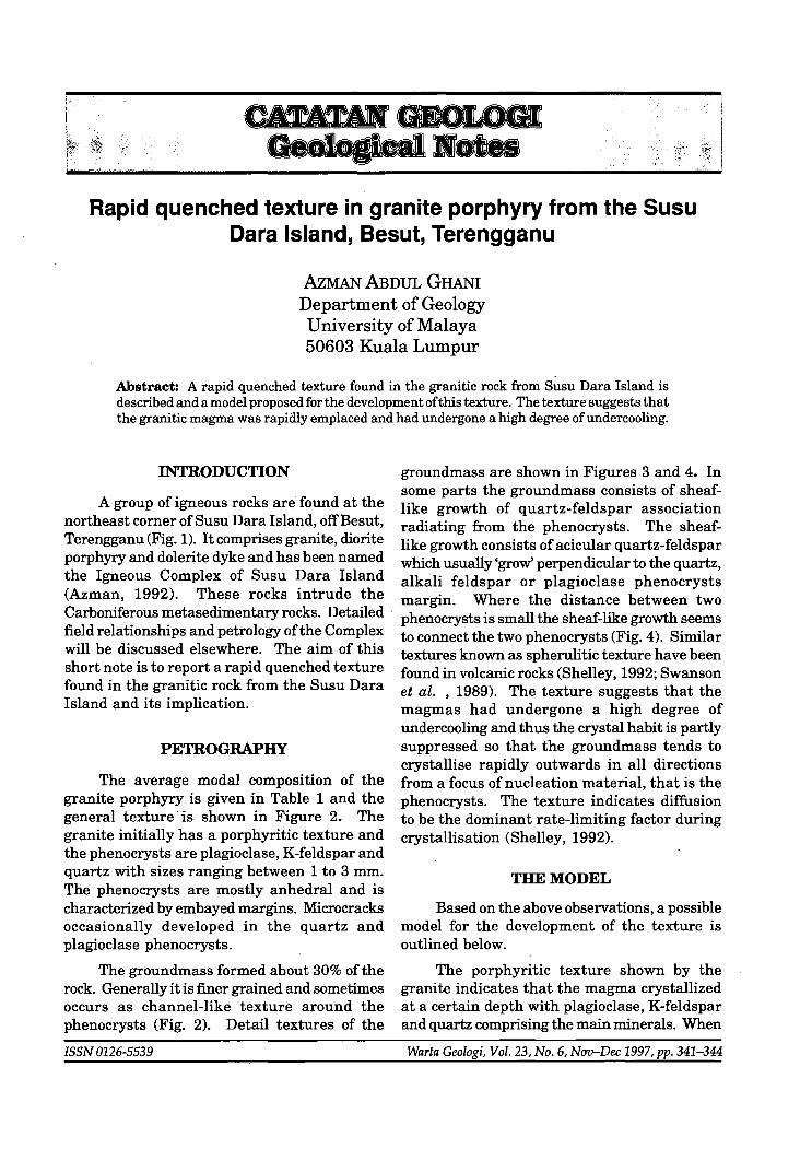
groundmass are shown in Figures 3 and 4. In some parts the groundmass consists of sheaflike growth of quartz-feldspar association radiating from the phenocrysts. The sheaflike growth consists of acicular quartz-feldspar which usually 'grow' perpendicular to the quartz, alkali feldspar or plagioclase phenocrysts margin. Where the distance between two phenocrysts is small the sheaf-like growth seems to connect the two phenocrysts (Fig. 4). Similar textures known as spherulitic texture have been found in volcanic rocks (Shelley, 1992; Swanson et al. ,1989). The texture suggests that the magmas had undergone a high degree of undercooling and thus the crystal habit is partly suppressed so that the groundmass tends to crystallise rapidly outwards in all directions from a focus of nucleation material, that is the phenocrysts. The texture indicates diffusion to be the dominant rate-limiting factor during crystallisation (Shelley, 1992).
TBEMODEL
Based on the above observations, a possible model for the development of the texture is outlined below.
The porphyritic texture shown by the granite indicates that the magma crystallized at a certain depth with plagioclase, K-feldspar and quartz comprising the main minerals. When
Warta Geologi, Vol. 23, No.6, Nov-Dec 1997, pp. 341-344

loneous S D Complex USU . oro
,,~ Keeli ~ ~~"=' ~ \8 Rowo
~O Susu Dora
Besar
~ Serenggeh
103°
. :. . "'Jr. ,,'
,'.'" I
, " , , , ,
\ I
I \
( I ... ' ..... '''' J' " ,- ~ , , \
\ WEST,
o I
, , MALAYSIA ','
km
Ip
6°
4°
2° N
SOU T H CHI N A
Pasir Korang
5 £ A
Pasir Palani
rn ~ [2]
/
N
( 0
+
Perhenlian Besar
LEGEND
Syenite
Granite
Metasediment
Undifferenciated mafic dyke
2 I
km
+
+
Figure 1. Map of the Pulau Perhentian and its surrounding area showing the location of the Pulau Susu Dara and the Igneous Complex.
C/.:)
~ t-:)
RAPID QUENCHED TEXTURE IN GRANITE PORPHYRY FROM THE SUSU DARA ISLAND, BESUT 343
Figure 2. Photomicrograph showing overall texture of granite porphyry from the Igneous Complex of Pulau Susu Dara. Note the groundmass form a channel-like texture.
(·5mm
.. ~ .'.
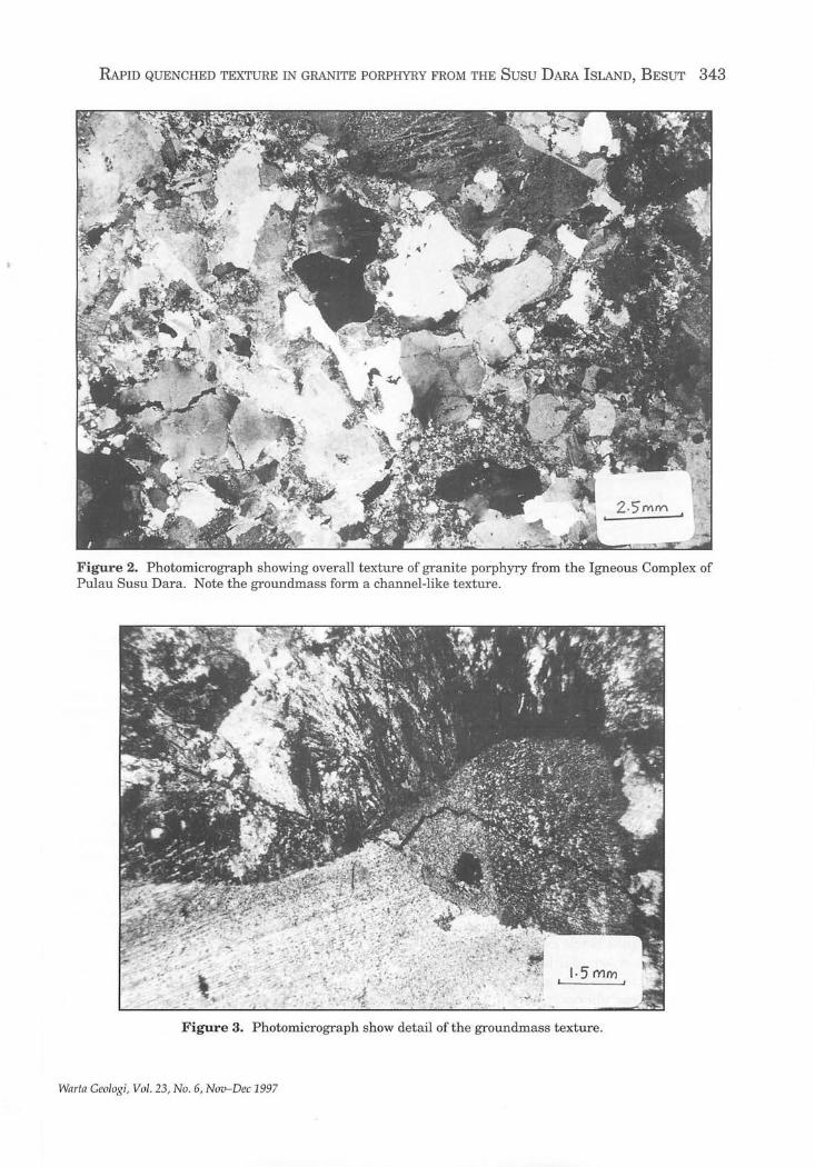
Figure 3. Photomicrograph show detail of the groundmass texture.
Wllr/a Geologi, Vol. 23, No . 6, Nov-Dec 1997

344 AzMAN ABDUL GHANI
0·3 rl'lTY1
Figure 4. Photomicrograph show detail of the groundmass texture. Note that the sheaf like growth connect the quartz and plagioclase phenocrysts.
Table 1. Average modal percentage of the granite to the rapid uplift (Vollbrecht et al., 1991). porphyry from Pulau Susu Dara.
Quartz (Phenocrysts) 27.1%
Plagioclase (Phenocrysts) 20.2%
K-feldspar (Phenocrysts) 19.1%
Groundmass 33.6%
the remaining melt is about 30% (from modal data), the granitic mush was rapidly upwelled to the surface. It is difficult to establish what mechanism was responsible for provoking the upwelling. However, the possible mechanisms are probably faulting (Leake, 1990) or shear zone movement (Hutton et al., 1990). The sudden emplacement process resulted in the remaining liquid quenching and crystallising rapidly outwards in all directions from a focus of nucleations, that is the existing phenocryst as an aggregate of acicular branches (Swanson et al., 1989). At this stage microcracks in quartz and plagioclase phenocrysts will develop due
REFERENCES
AzMAN A. GHANI, 1992. Petrologi dangeokimia kawasan Pulau Perhentian dan pulau·pulau sekitarnya, Besut Terengganu. BSc thesis, Universiti Malaya.
HurrON,D.H.W.,DEMPSTER,T.J.,BROWN,P.E.ANDBEKER,
S.M., 1990. A new mechanism of granite emplacement: intrusion in active extensional shear zone. Nature 343, 452-455
LEAKE, B.E., 1990. Granite magmas : their sources, initiation and consequences of emplacement. Jour. Geol. Soc. Lond. 147,579- 589.
SHELLEY, D., 1992. Igneous and metamorphic rocks under microscope: Classification, textures, microstructures and mineral preferred orientations. Chapman and Hall, 445 p.
SWANSON, S.E., NANEY, M.T. AND WESTRICH, H.R., 1989. Crystallisation history of obsidian dome, Inyo Domes, California. Bull. Volc., 51, 161- 176.
VOLLBRECHT, A., RUST, S. AND WEBER, K. , 1991. Development of microcracks in granite during cooling and uplift: examples from the Variscan basement in NE Bavaria. J. Struct. 13(7), 787-799.
---------~~.-.---------Manuscript received 9 October 1997
Warta Geologi, Vol. 23, No. 6, Nov-Dec 1997

Preliminary Electronprobe Microanalyzer (EPMA) characterisation of gold deposits of the
Raub-Tersang-Selinsing-Penjom and Rusila areas
G.H. TEH, H ELMI M OHD L ATIB AND Z ULPAKAR M OHAMAD J USUH
Geology Department University of Malaya 50603 Ku ala Lumpur
Abstract: Secondary electron (SE) and backscattered electron (BSE) images of the electronprobe microanalyzer (EPMA) coupled with spot analyses, inclusion studies and X-ray mapping of surfaces of gold samples show the ideal application of the EPMA in the characterisation ofthe various primary and secondary gold occurrences in the Raub-TersangSelinsing-Penjom and Rusila areas.
Gold from the different areas show variations in Au content together with variable quantities of Ag, Si, AI, Sn, Te, Fe, Sb, Pt, Cu, Pb and Pd. The fineness of primary gold averages 898.898 for Rusila, 957.398 for Raub, 950.796 for Kecau and 882.323 for Selinsing.
INTRODUCTION
As gold is precious and usually occurs in very small quantities as primary gold in mineralised quartz veins and secondary gold in alluvial deposits, the electronprobe microanalyzer (EPMA) has t urnout to be an ideal tool for ch aract erising primary and secondary gold.
Besides studying the morphology of the gold specimens u nder the EPMA, other characters noted include their elemental compositions, fineness and their inclusions.
MATERIALS AND METHODS
In the stu dy, gold was collected from the Raub-Tersang-Selinsing, Kecau and Penjom areas in Pah ang (Helmi, 1997) and the Rusila area in Terengganu (Zulpakar, 1997). The samples include primary gold from gold-quartz veins from the various deposits and secondary gold was panned from the rivers in the vicinity of the above-mentioned areas and some tailings samples in the vicinity of Tersang and Penjom were also studied.
ISSN 0126-5539
The secondary gold samples were mounted on carbon tapes and their morphology studied in detail on the EPMA after preliminary petrological microscope and binocular examination. Some of the bigger primary gold samples were chipped offfrom the quartz veins and studied in the same manner.
After the morphological studies, t he gold samples were then mounted in resin and polished thin sections were prepared for analysis with the EPMA utilising the fully integrated energy dispersive spectrometer (EDS), for fast full spectrum scan of elemental compositions, and the conventional wavelength dispersive spectrometers (WDS), for accurate composition determinations.
The EPMA available at the Geology Department, University of Malaya is a highly automated Cameca SX100 which is workstationbased, with full instrument control coupled with quantitative, qualitative and imaging software via windows and multi-task user environment.
Besides optimal viewing, the EPMA can acquire secondary electron (SE) images for better
Warta Geologi, Vol. 23, No . 6, Nov-Dec 1997, pp. 345-349

Figure 1. BSE images of a primary gold sample with jagged outline Oeft) and that of an alluvial sample with well-rounded surfaces (right)
Figure 2. BSE image Oeft) showing gold (bright) clearly discernible from quartz (grey) which cannot be differentiated on the SE image (right)
Figure 3. Gold (light) with inclusions of iron (left, grey) and silver (right, grey).
ELECTRONPROBE MICROANALYZER (EPMA) CHARACTERISATION OF GOLD DEPOSITS 347
Wnrtn Geologi, Vol. 23, No.6, Nov-Dec 1997

348 G.H. TEH, HELMI MOHD LATIB AND ZULPAKAR MOHAMAD JUSUH
'j
'i
lJ
Warta Geologi, Vo l. 23, No.6 , Nov-Dec 1997

ELECTRONPROBE MICROANALYZER (EPMA) CHARACTERISATION OF GOLD DEPOSITS 349
differentiation of topography as well as backscattered images (BSE) for elemental composition differentiation (Teh, 1996a and 1996b).
RESULTS AND DISCUSSION
The backscattered electron (BSE) images appeared to be ideal for defining the morphology of the primary and secondary gold grains besides differentiating gold from other elements of different atomic number (Figs. 1 and 2). However the secondary electron (SE) images on some occasions give a better picture of the topography of the gold grains (Fig. 2).
Data on the gold probed from the primary and secondary gold samples from the different areas show variation in the Au content together with variable quantities of Ag, Si, AI, Sn, Te, Fe, Sb, Pt, Cu, Pb and Pd. It appears that the gold from certain areas have distinctive fineness and traces of some of these elements (Fig. 3). The fineness of primary gold in the Rusila area averages 898.898 while that at average for Bukit Koman (Raub) averages is 957.398, for Kecau is 950.796 and for Selinsing is 882.323. Mineral inclusions in gold are mainly chalcopyrite, pyrite, hematite, arsenopyrite and quartz.
The X-ray maps generated can clearly serve as useful guides to the actual elemental or mineral distribution within the gold grains (Figs. 4 and 5). Such information is useful for determining inclusions in the gold grains, the paragenesis of a particular gold deposit besides providing useful information on its genesis.
CONCLUSIONS
This preliminary study shows the useful role the EPMA can play in the characterisation of primary and alluvial gold deposits in Peninsular Malaysia. The data accumulated from both the primary and secondary gold samples can help in delineating or reflecting the nature of the source or sources of the gold.
ACKNO~DGEMENTS
This research is supported in part by the research fund of University of Malaya, under project F492/97.
REFERENCES
HELM! MOIm LATIB, 1997. Kajian EPMA (Electron Probe Microanalysis) danmikroskopiemas kawasan Raub-Selinsing, Penjom dan Kecau, Pahang Darul Makmur. Universiti Malaya B.Sc. (Hons.) Thesis (unpublished), 46 p.
TEH GUAN HOE, 1996a. Electronprobe X-ray microanalysis of geological samples. In: Proceedings 6th Scientific Conference, Electron Microscopy Society Malaysia, 26-27 October 1996, Petaling J aya, 26-27.
TEH GUAN HOE, 1996b. Electronprobe microanalysis and geochemistry of a complex Cu-Fe-Sn-Zn ore. Warta Geologi, 22(6), 389-394.
ZULPAKAR BIN MOHAMAD @JUSUH, 1997. Ciri-ciri emas primer, sekunder serta mineral inklusi di kawasan Lubuk Mandi, Rusila, Terengganu. Universiti Malaya B.Sc. (Hons.) Thesis, 36 p.
---------.~.-~~.+-.--------
Manuscript received 11 October 1997
Warta Geologi, Vol. 23, No.6, Nov-Dec 1997

~~w@~ @lJ~lJIJ@~[g]D©
@(wD[Q)~
Malaysian Stratigraphic Nomenclature Committee
Geological Society of Malaysia December 1997
SPECIAL LOW-PRICED SOFT-COVER EDITION LIMITED STOCK! . GET YOUR COPY NOW!
Member : RM5.00 PRICE: Non-Member : RMIO.OO
Student Member : RM2.00 Cheques, Money Orders or Bank Drafts must accompany all orders. The Hon. Assistant Secretary Orders will be invoiced for postage and bank charges. Orders should be GEOLOGICAL SOCIETY OF MALAYSIA addressed to: c/o Dept. of Geology, University of Malaya
50603 Kuala Lumpur, MALAYSIA

Groundwater protection in Kelantan SAlM SURATMAN
Laporan (Report)
351
Dr. Saim Suratman gave the above talk on Monday, 3rd November 1997 at the Department of Geology, University of Malaya. He is attached to the Geological Survey Malaysia and recently obtained his Ph.D. from University of Newcastle-upon-Tyne. His talk, which is based on his Ph.D. research proved very interesting and attracted a crowd of about 55.
Abstrak (Abstract)
The North Kelantan River Basin is underlain by flat lying Quaternary alluvium which ranges in thickness from a few metres inland to more than 200 m at the coast. The alluvium contains two different aquifer systems, known as the shallow aquifer (which is quite thin and mostly unconfined), and the deep aquifer (which is mainly confined with thickness usually more than 15 m). The shallow aquifer is the most important aquifer system for the public water supply systems of the area and contributes a remarkable 90% ofthe total drinking water demand. These two main aquifer systems are hydraulically interconnected being separated only by semi-permeable silt.
A comprehensive study on the groundwater systems in the North Kelantan River Basin was carried out using groundwater models and Geographical Information Systems (GIS). Through the modelling and GIS, considerable advances in the understanding of the aquifer systems in relation to hydrogeochemical properties, groundwater contamination, groundwater flow, wellhead protection area (WHPA) delineation and groundwater vulnerability mapping have been realised.
A groundwater flow model for North Kelan tan was constructed using a three-dimensional regional groundwater flow code (MODFLOW), together with the particle-tracking program (MODPATH) to calculate the pathlines and time-of-travel (TOT). The results ofthe modelling works were integrated into GIS using ARCIINFO and ArcView. The GIS also supported storage, analysis, querying, browsing and display of various geographical data available for the study area. This allowed visualisation and better understanding ofthe aquifer systems, aiding plans to protect the groundwater from further deterioration in quality.
The groundwater in North Kelantan is naturally rich in iron which exceeds the raw water quality limits. Contamination by nitrate and ammonium is quite apparent, resulting from various human activities in the urban and agriculturally active areas.
The 50-day, I -year, IO-year and 20-year TOT zones for source protection have been adopted in the interests of protecting the groundwater from contamination, and vulnerability mapping using the new RUSTICS method (modified from DRASTIC) was carried out to map the areas vulnerable to pollution.
Wnrtn Geologi, Vol . 23, No . 6, Nov-Dec 1997

352 The project demonstrates the feasibility and desirability of integrating source protection
zone delineation with regional groundwater vulnerability mapping by integrating groundwater models with GIS. The benefits of adopting generic vulnerability mapping technique to local land use circumstances are also clearly shown.
G.H. Teh
------------~.~ . .-~~.~.~.------------
Recent developments in modem temperate and polar carbonates and their significance in the exploration of oil, gas and mineral deposits C. PRAsADA BAo
Laporan (Report)
Dr. Rao, who is Associate Professor at the Dept. of Geology, University of Tasmania, Hobart, Tasmania, Australia, gave the above talk. on 18th December 1997 at the Geology Department, University of Malaya. We thank Dr. Rao for always sharing the results of his latest research whenever he is in town.
Abstrak (Abstract) Carbonate rocks contain about 50% of the world reserves of oil and gas and they are host
sediments for many mineral deposits. These resources are currently being explored based mainly on modem and ancient tropical carbonate depositional and diagenetic models. This talk presents nontropical exploration models by comparison between modem and ancient temperature and polar carbonates. Extensive modem temperate and polar carbonates have been recently discovered from both the northern and southern hemispheres. The nontropical carbonates differ from tropical counterparts in sedimentological, elemental and isotopic characteristics. Comparison of these carbonates with depositional, diagenetic and geochemical models of modem temperate and polar carbonates enable better understanding origin and ancient non-tropical carbonates. These models form the basis in the determination of reservoir characteristics, and selection of suitable sites for exploration of oil, gas and mineral deposits in ancient nontropical carbonates that are widespread in the geological history.
G.H. Teh ----------__ .~.M • .-~~.~.~. __ ----------
Warta Geologi, Vol. 23, No.6, NUD-Dec 1997

Ceramah Teknik (Technical Talk)

354
A study of some clay soils in South Wales and their potential use as landfillliners TAN BOON KONG
Laporan (Report)
The talk on "Attenuation characteristics of some clay soils from landfill sites in South Wales, u.K." was presented by Mr. Tan, B.K. (UKM) at the Dept. of Geology, University of Malaya on Friday, 19th December 1997. It was chaired by Dr. C.P. Lee, who stood in for Mr. Muhinder Singh who had prior commitment in Singapore.
An abstract for the talk is enclosed below.
Unfortunately, response to the talk in terms of audience/attendance was rather disappointing. This may perhaps be due to the coming festive/X'mas holidays, nature ofthe talk, the speaker, current economic slow-down, etc., etc.?? In any case, for those who attended, they were also taken on a "quick tour" of Wales through a series of colour slides showing the scenic coastal landforms, beaches, mountains and plenty of castles at the end of the talk.
Abstrak (Abstract)
A comprehensive laboratory study of some clay soils from several landfIll sites in South Wales was completed recently, with the primary objective of evaluating the suitability ofthese soils as potential landfIll liner or sub-base materials. Materials investigated include estuarine alluvium, weathered Coal Measures mudrocks and glacial till. By virtue of their widespread occurrence, these materials are of vital importance in the strategic planning of landfIll sites in South Wales. The laboratory tests conducted include detailed physicochemical and mineralogical properties of the soils, batch-equilibrium and leaching column tests, the latter two tests involving heavy metal species (Zn2+, Pb2+, Cu2+) representing common contaminants in landfIll sites. Results of the various tests are reported in this paper. Among others, the test results show: distinct differences in characteristics and behaviours due to different geologic materials (alluvium versus mudrocks versus glacial till); estuarine alluvia from two different sites have strikingly similar properties; greater fInes contents and hence plasticities for the alluvium compared to mudrock soils and glacial till; higher compacted densities and permeabilities for the mudrocks and glacial till (compared to alluvium) due to
greater coarse fractions; higher specifIc surface areas and cation exchange capacities for the alluvial soils; relatively higher organics contents for the alluvium; very high ionic contents for the alluvium (estuarine); poor attenuation and buffering capacities ofthe mudrock soils compared to the glacial till which is far superior in these respects. Clay mineralogical compositions of all soil types tested are by-and-Iarge similar and are more akin to illite (predominant) + kaolinite. The test results, in particular from the leaching column tests, indicate that the glacial till would be a suitable landfIll liner material with high retention capabilities for heavy metals and high buffering capacity against change in pH.
Tan Boon Kong
29.12.1997
Wnrtn Geologi, Vol. 23, No.6, Nov-Dec 1997

New Zealand's largest historic earthquake RODNEY GRAPES
Report
355
Dr. Rodney Grapes, who is Head of the Analytical Facility, Research School of Earth Science, Victoria University of Wellington, Wellington, New Zealand, gave a very interesting account of New Zealand's largest historic earthquake on the 29 December 1997 at the Geology Department, University of Malaya. The author had faxed us the extended abstract of his talk for the benefit of all members.
Extended Abstract The earthquake of January 23 1855 is New Zealand's largest earthquake since
organised European settlement. Surprisingly there is no comprehensive account other than that of great British geologist, Sir Charles Lyell, based on information given to him by three eyewitnesses. Naturally, Lyell's account is mainlyconcemed with the geological aspects of the earthquake, faulting, uplift and subsidence, and New Zealand featured in his work as a prime example of the enormous forces accompanying a great earthquake which could lift and crack a huge tract ofland injust a few moments, the most extensive such movement that was then known.
The settlement of Wellington (now the capital of New Zealand), just fifteen years old, seems to have been the closest town to the epicentre of the earthquake. On January 23 residents were enjoying the second of two days of festivities celebrating the founding of the settlement. At about 9.15 pm, the earthquake occurred, suddenly and without warning. Accounts from Wellington and vicinity indicate that it lasted at least 50 seconds and possibly strong shaking went on for up to three minutes. Some people thought they could identify two
MocWied Mercalli scale isoseismals (IV to X) of damage for the 1855 earthquake
Warla Geologi, Vol. 23, No.6, Nero-Dec 1997
Map showing the 1855 earthquake rupture of the Walrarapa Fault and land area uplifted (shaded). Coastal uplift values (in metres) are measurements made shortly after the earthquake. Approximate position of epicentre Is given by the star.
) /
20 40 km L-__ .L1 __ .-I
Cape Palliser

356 or three separate shocks within that time. Aftershocks followed immediately, were frequent in the first two weeks, and even six weeks later at least one or two shocks were being felt daily. In Wellington, there were so many aftershocks that identifying the times of individual events seems to have been too much for the diarists of the time. One diarist had counted 250 shocks by 8 am on the morning after the first shock and another 100 more in the next twenty four hours and it is clear that he, like many others was unable to sleep that night. Many moved out of their houses into hastily erected tents. Assessment from the contemporary evidence indicates that at least five aftershocks had magnitudes of about ML6.5 and many had magnitudes greater than 5.0. Over a year later, aftershocks were still being felt.
The mainshock was felt over about 135,000 square kilometres, almost the entire land area of New Zealand. People on ships at sea also felt it, thinking that the ship had struck a reef or grated over rocks. The effects on people, buildings and the environment have been assessed using the Modified Mercalli scale of felt intensity (MM scale, adapted for New Zealand) to produce an isoseismal map in which contours enclose areas that have experienced approximately the same MM intensity. The isoseismal map is shown in the figure. Comparison of the isoseismal map of the 1855 earthquake with those of the instrumentally determined 1931 Hawke's Bay and the 1929 Buller earthquakes, both with magnitudes of7.8 show that the 1855 event must have been greater with a magnitude between 8 and 8.2.
Auckland in the north and Dunedin in the south felt the main earthquake at intensity MM3, but in Wellington and the central part of New Zealand, the damage was greatest and resulted in at least five, and possibly nine deaths. Wellington and environs were badly damaged, to intensity MM9, but few buildings were totally demolished. Mostwell-constructed wooden buildings suffered little structural damage other than from chimneys falling through the roof. The Government Offices, though wooden, collapsed because the supports, constantly wet, had rotted. In the northeastern part of the South Island most sod and cob (Le. clay) houses were badly cracked and many completely destroyed. Chimneys as far away as New Plymouth in the north and north Canterbury in the south were cracked. In Napier, over two hundred kilometres NE from Wellington, the Reverend William Colenso, the well known missionary and traveller, ran from his house and clung to the ground. There, he says in a letter to his friend Joseph Hooker at Kew Gardens in England, "the tall weeping willows with which I was surrounded threw their long drooping branches about in an imploring, frantic way - now lashing the earth, and now sweeping the sky ...... the post and rail fences too, which were very dry, joined in with their unnatural notes and creaked and clattered prodigiously". Unfortunately Colenso, like many other settlers, often chose to build their houses close to rivers or the sea, areas frequently underlain by alluvium, and it has been found that these areas are often subject to stronger shaking, resulting in greater building damage. In addition, the ground in these areas when subject to very strong shaking can liquefy, that is, lose its strength to support structures and act as a liquid. Sand fountains often occur and the ground can settle differentially.
Reports of superficial ground deformation in the form of extensive cracking and fissuring, sand fountaining, subsidence from compaction, and landslidingoccurred over about 52,000 square kilometres. A graphic description of how parts of the Wairarapa Plain, east of Wellington appeared after the earthquake comes from William Bennet, a civil engineer, and serves to illustrate the typical nature of the ground deformation; "the ground (had) opened in many places 8 or 9 feet [2.4-2. 7 m], and sunk in one place for 300 yards [270 metres] square to a depth of 8 or 9 feet [2.4-2.7 metres]. The cracks were very frequent, and at first were of considerable depth (deemed unfathomable because people could not see their depth), perhaps 15 or 20 feet [4.~.0 metres] in depth, and extending for many hundred yards [metres]. Ploughed ground and mud, dry river or pond-beds were thrown into all sorts of undulations like a short cross sea, the ridges in some cases 2 feet [6 m] in height, the prevailing direction of the cracks and ridges being generally at right angles to the apparent line offorce, NE-SW". The RimutakaRange, between Wellington and the Wairarapa Valley where it reaches Cook Strait, was described as being "tom to pieces"by extensive landslides that carried away almost a third of the vegetation on both the eastern and western flanks.
Larger scale deformation of the earths crust caused by the earthquake were even more dramatic and were described by Sir Charles Lyell as, "the formation of a great fault and of an upheaval which is greatest in vertical height and horizontal extent that all dislocations of this kind that I am aware of to date". Surface rupture occurred on what is now known as the
Warla Geologi, Vol. 23, No.6, Nov-Dec 1997

Wairarapa Fault and according to Lyell's informants and fissure ran for an "amazing distance of90 miles [150 kml" along the western side ofthe Wairarapa Plain close to the base of the Rimutaka Range. Uplift of the Rimutaka Range side of the fault at Palliser Bay was 9 ft [2.7 m] and was measured from the elevation of a white band of coralline encrustation that grew on the rocks up to low tide level. All along the western side of Palliser Bay, around Turakirae Head and along a large part ofthe south Wellington coast, the uplift stranded a wide gravel beach together with rock platforms both inside and outside Wellington Harbour. Along the fault break uplift gradually decreased to the NE.
Horizontal displacement also occurred on the Wairarapa Fault during the earthquake and amounted to 12 m with the Rimutaka Range side of the fault moving northeast relative to the Wairarapa Valley side. However, such movement was not recognised at the time. This is not surprising as disruption of man-made features such as a road or fence line are the most obvious reference lines for indicating horizontal movement on faults. It took another 100 years before the offset of various features such as streams and river terraces extending across the Wairarapa Fault were recognised as indicating that the land on either side of the fault could move horizontally as well as vertically. Contemporary evidence that horizontal movement did occur on the Wairarapa Fault in 1855 is possibly implied by reports of sudden rise in water level by 2-3 m along the southwestern side of Wellington Harbour immediately after the first shock of the earthquake that flooded the beachfront shops and houses along Lambton Quay. This rise in water level could be explained by the effect of a sudden northeast shift of the land west of the Wairarapa Fault and is analogous to the effect produced when a water-filled basin is jerked horizontally.
In addition to fault rupture, some 5,000 square kilometres of the southern part of the North Island west of the Wairarapa Fault was elevated. Coastal measurements ofthis uplift indicate that it gradually decreased in a northwest direction from the greatest elevation along the west side of Palliser Bay. At Wellington the uplift was about 1.5 m and at Porirua on the west coast about 0.4 m. Across Cook Strait in the lower part of the Wairau Valley, in the north eastern part of the South Island, subsidence occurred. Reports of the amount of subsidence vary between 1.5 and 0.6 metres and can best be explained by differential compaction of soft alluvium coupled with regional tectonic subsidence.
Another notable feature associated with the 1855 earthquake was the tsunami and seiche effects. A seiche is a regular side-to-side oscillation of an enclosed body of water which may be induced by earthquake, but by far the most common cause is wind. Seiching in Wellington Harbour following the mainshock is described in many accounts but there is also evidence for seiching in lakes and rivers in both islands and Lyttelton Harbour near Chrischurch and probably in Otago Harbour in the South Island. About 10-15 minutes after the first shock of the earthquake a tsunami swept the coasts on both sides of Cook Strait and water levels rose and fell for some hours. In Cook Strait the wave was estimated to have been about 9-10 metres high. The water in Wellington Harbour continued to ebb and flow for about twelve hours after the first shock, the movement being a combination of at least three effects, the sudden lateral displacement of the land west the Wairarapa Fault, regional uplift and the tsunami generated in Cook Strait entering the harbour. At the same time because ofthe uplift there was an "excess" of water in the harbour which had to drain out, not to mention the normal tidal oscillation. The morning after the earthquake an enormous number of dead fish were seen floating on the surface in the middle of Cook Strait. It was remarked that these were mainly a bottom-dwelling variety (ling). Such fish are sensitive to rapid pressure changes and may have been killed when they were forced to quickly ascent due to landslide-generated turbidity currents caused by the earthquake. Fish were also stranded by the tsunami along the south Wellington beaches and on sand dunes along the southern part of the west coast of the North Island. These were probably near shore-feeding shoals that were caught by the tsunami.
Information on the distribution of building damage and ground damage of this earthquake and other historical and present day earthquakes is not just interesting but provides valuable information needed to understand the hazards that we are likely face in a large earthquake. Using such information, earthquake engineers can design structures and services to resist the effects of strong shaking and geologists and seismologists can identify areas susceptible to enhancement of shaking and faulting. Emergency response organisations in New Zealand can better prepare for the time when we may have a large earthquake. Even
Warta Geologi, Vol. 23, No.6, Nov-Dec 1997
357

358 in 1855 the damage and casualties in Wellington were less than they might have been because seven years earlier in 1848 another earthquake, oflessermagnitude and centred in Marlborough, had taught the settlers that wooden structures survived where bricks and mortar fell. The early settlers were resilient, they had come to a new country far away from their homeland and were not easily daunted. Repairs were made, and a study of the best methods of building to resist earthquakes was carried out. The structural damage suffered by Wellington provided the data. Charles Carter, a builder and one of the authors of a damage report was perhaps first in the world to suggest the adoption of a building code. Unfortunately it was to be another 20 years before building regulations were adopted.
The Wairarapa Fault which moved in 1855 shows geomorphic evidence of repeated movement over the last 10,000 years. The youngest Last Glacial alluvial surface cut by the Wairarapa Fault has been dextrally displaced by 127±5 m and vertically displaced by ca. 20 m. This, in conjunction with progressively smaller displacements preserved in a flight of degradation terraces (e.g. Waiohine River) suggest the possibility that 10 or 11 coseismic displacements similar to that of 1855 have occurred on the Wairarapa Fault during HoloceneLate Quaternary time. Carbon 14 dating from one locality suggests that four earthquake displacements prior to 1855 have occurred within the last 6.5 ka and that the time interval between them varies between 1,100 to 1,900 years. The 1855 pattern of regional uplift and northwest tilting across Wellington peninsula is also shown by older earthquake-standed beach ridges dating back to 6.5 ka when present-day sea level was established.
New Zealand sits astride the boundary between two converging tectonic plates, the Australian and the Pacific. The Wairarapa Fault which shows evidence of repeated movement is the most active fault in the southern part of the North Island with a dextral slip rate of ca. 12 mm/yr and accounts for about half the Ca. 21 mm/yr margin parallel slip rate associated with oblique subduction of the Pacific Plate along the Hikurangi Trough east of New Zealand. Stresses and strains created by this convergence are relieved by many small and moderate magnitude earthquakes, and less frequently, a large earthquake. In the last one hundred and fifty five years, New Zealand has experienced three large earthquakes of magnitude 7.8 or more, the 1855 earthquake, the 1929 Buller earthquake and the 1931 Hawke's Bay earthquake. What happened during a large earthquake a hundred years ago is very relevant to understanding what' might happen in a future earthquake of comparable magnitude. Information from past and present earthquakes is required to build a more complete picture of their causes and occurrence in New Zealand and the hazards they pose.
G.H. Teh ----------____ •• ~.~~~ ..... I-------------
Warta Geologi, Vol. 23, No.6, Nov-Dec 1997

Sedimentology and Stratigraphy Study Group Visit to Batu Arang Tertiary Basin
359
GSM's Sedimentology and Stratigraphy Study Group organised a fieldtrip to Batu Arang on the 16th of November 1997. The trip was the first of their series of activities for 1997-98. Seven participants turn up (A good 70% turnout as the trip was open only for 10 participants, on first-come, first-served basis). Assoc. Prof. Dr. Azhar Hj Hussin from the University of Malaya Geology Department was the leader of the trip. Mr. Low Teng Huat from Asiagro Resources Sdn. Bhd. was the only "outsider", Che N orliza Lat, Arulmani Shanti and the author himself are all UM's Geology dept. staff; Intan Suhaila is a 4th Year student and Ubaidullah is a third year student at the department.
The Tertiary succession of Batu Arang is a coal-bearing sequence of sediments dominated by carbonaceous shale and clay, and fine-grained sandstone. This succession is capped with a thick sequence of boulder conglomerate. The lower coal-bearing section is no longer visible, due to the flooding of the mining pit. However, new exposure of the middle brown shale and sand and an excellent new hill-cut of the top boulder conglomerate allow the group to have a good look at the stratigraphy of the basin.
Dr. Azhar briefthe participants on the geology, the history of the coal and shale mining in the area and the history ofthe growth ofthe town, closely linked to the industries related to the mining activity. The participant had a chance to search and collect some fairly well preserved fossil leaves in the brown shale succession. Intan Suhaila concluded the visit with a summary of her interpretations ofthe study she carried out on the boulder beds . The trip ended at around 1.00 pm.
Abdul Hadi Abd. Rahman
Dr. Azhar pointing out to some interesting feature in the field .
Wnrtn Ge%gi, Vol. 23, No.6 , Nov-Dec 1997

360
The 20th Petroleum Geology Conference was held on 1 & 2 December 1997 in Hotel Istana, Kuala Lumpur, with the theme "Reborn Frontiers - meeting the challenges with technology ... '. About 300 participants from Malaysia, England, Australia, Singapore and Japan attended this conference which also included students from the local universities namely Universiti Kebangsaan Malaysia, universiti Malaya and Universiti Sains Malaysia.
The welcoming address was delivered by Mr. Jimmy Khoo, vice-president of the Geological Society of Malaysia. In his speech, he spoke on the current and future activities of the Geological Society of Malaysia and thanked all the sponsors and exhibitors for their support. The opening address was delivered by Mr. Yeow Kian Chai, General Manager, Petroleum Management Unit, E&P Business, PETRONAS. In his speech, he praised the Geological Society of Malaysia for their consistent effort to organise an annual petroleum geology conference with the aim of promoting new exploration ideas and geological concepts and even just to share the experience within the petroleum fraternity. He also updated the learned audience on the oil and gas exploration in Malaysia. In view of the diminishing size of our prospects, he encourage the oil companies to utilize the latest technology in their search for these elusive hydrocarbons. On the commercial side, he conveyed to the gathering that, the government of Malaysia and PETRONAS have also accomplished much to attract oil companies to invest in Malaysia including the reduction of PTTA and export duty and the introduction of the more liberal RIC terms in the Malaysia PSC.
A total of 24 technical papers were presented in the 2-day conference. Five papers touched on the latest 3D technology-coherence cube processing and interpretation. Nine service companies occupied the ten exhibition booths to provide a carnival-like atmosphere to the conference. The first day lunch was sponsored by Schlumberger (M) Sdn. Bhd. and the second by International Petroleum Corporation (lPC). The ice breaker reception on the first night was sponsored by Western Atlas (M) Sdn. Bhd. while Dexcel sponsored the conference bags. Besides these main sponsors the other companies who contributed significantly to the conference, include Triton Oil Company of Thailand (JDA) Ltd., Gaffney, Cline & Associates (Consultants) Pte. Ltd., Nippon Oil Exploration (Malaysia) Ltd., and Overseas Petroleum and Investment Corporation (Malaysia) Branch.
It is noteworthy that the conference was very successful despite the fact that the chairmanship changed hands at a rather late stage. It could have been aborted. The earlier chairman could not continue due to additional official duties he had to performed in his company and the earlier venue for the conference was not available anymore. The new chairman of the organising committee, Robert Wong, promptly gathered a new group of dedicated team members to organise the conference successfully within a short span of time (less than two months) that included the difficult task of searching for a new suitable venue. Finally, the conference was carried out without a hitch. The performance of Robert Wong and his team is simply outstanding. In the end, the participants and the exhibitors were surprised at the good turnout and that the conference was so well organised and everything fell so neatly into place.
Robert Wong & G.H. Teh
Warta Geologi, Vol. 23, No.6, Nov-Dec 1997

361
~tIIU#It,Q, J.uJ,. ~1f4H, P~ Majiu., 1(tUSf /J~ M"" 1(~ ~ fJku., Q~~, P~ M~fIHUJIf,t ty,,;,t, P~,
1(tUSf /J~ M"" Ro/JeIJ 'kItuuj, fJlUJG"i~i"9 fJ~ 0/ tIt.e 1997 P~ QeoI.otw fJ~, 3J~t;",r;HidIuJ QIUI4iI" PGtlicipa"u, .eaJuu. GHJ Q."u."".",
On behalf of the President of the Geological Society of Malaysia who is unable to join us this morning and the Council of the Geological Society of Malaysia, I wish to extend a warm welcome to Mr. Yeow Kian Chai, all distinguished guests and to you fellow-participants, to this 20th Petroleum Geology Conference.
It was almost exactly 20 years ago today that the GSM held its first "Seminar on the Petroleum Geology of the Sunda Shelf' on 16th December 1997 at the Equatorial Hotel here in Kuala Lumpur. Back then it was a one day event with only 9 papers presented but with some 160 participants. Today, we have progressed to a 2-day event with 24 papers, an exhibition by 9 companies and with over 200 participants from overseas and local companies and agencies, including budding scientists from our local institutions of higher learning. We have upgraded the event to a conference status. We even have a theme for this year's conference - "Reborn Frontiers - meeting their challenges with technology" .
.eaJuu. GHJ Q."tIe..",
It is also timely to convey to you that so far this year the GSM Council had worked very hard to bring for its members' benefits in particular, and the geoscience fraternity in general, events which returned your subscriptions many fold. Some of these events are:
• the holding of 12 technical talks, here and in Ipoh,
• held the Annual Geological Conference '97 at Kijal, Terengganu on 31st May - 1st June 1997,
• issue a booklet on the "History of the GSM",
• printed a poster on "Common Malaysian Rocks and Minerals" which were given free of charge to all secondary schools here in Selangor,
• held a geological photography contest which was closed recently and the results of the winning entries will be announced soon.
For the immediate future, we will be holding a "Seminar on the Tertiary Basins of Peninsular Malaysia and Adjacent Offshore areas" (21-22 February 1998), a seminar on "A Dynamic Stratigraphy of Peninsular Malaysia" (25-26 April 1998), more technical talks, and, the biggie for 1998 - the Ninth GEOLOGY of SE Asia Conference (or the GEOSEA as it is more commonly known) scheduled for 17th to 19th August 1998. For this reason, in 1998, there will be no Annual Geological Conference and no Petroleum Geology Conference next year but the GEOSEA Conference will incorporate oil and gas papers including workshops. This GEOSEA
Warta Geologi, Vol. 23, No.6, Nov-Dec 1997
362 Conference will also bring together both "hard rock" and "soft rock" geoscientists under one roof which so far have held separate conferences individually. So please mark this important date into your 1998 diaries and continue to give us your support next year.
Many companies and individuals have contributed both in cash and effort to make this present conference a reality. I would like to thank:
• Schlumberger (M) Sdn. Bhd. for sponsoring today's lunch, • International Petroleum Corporation for sponsoring tomorrow's lunch, • Western Atlas (M) Sdn. Bhd. for sponsoring tonight's Ice-breaker reception, • DEXCEL Sdn. Bhd. for sponsoring the conference bags,
donations from:
• Triton Oil Company of Thailand (JDA) Ltd., • Gaffney, Cline & Associates (Consultants) Pte. Ltd., • Nippon Oil Exploration (Malaysia) Ltd., and, • Overseas Petroleum and Investment Corporation (Malaysia branch).
We have also received support from various exhibitors who took up booth spaces outside this conference hall, namely:
Jason Systems B.V., Teknosif Sdn. Bhd., Atlas Wireline Services, Schlumberger (M) Sdn. Bhd., Landmark Graphic (M) Sdn. Bhd., PGS Exploration, DEXCEL Sdn.'Bhd., Dataminda Sdn. Bhd. and Coherence Technology Co. Inc.
Ladies and Gentlemen, please spend time during your coffee breaks to visit these exhibitors' stalls as I am sure you will be impressed with the technology presented not to mention, the freebies you may get.
Lastly, it remains for me to thank the person who initiated the start ofthe organisation of this conference, Encik Mohd Kassim Kinchu; the organising chairman Mr. Robert Wong and his committee who had tirelessly worked very hard to bring off this conference in its present form, and; to all of you for your presence here today.
Thank you and a warm welcome to the 20th Petroleum Geology Conference.
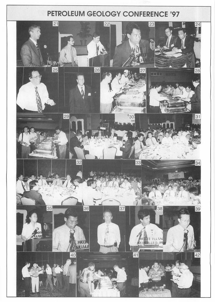
PETROLEUM GEOLOGY CONFERENCE '97 Captions to Photos
1-3. At the Registration Desk. 4. Welcoming Speech by GSM Vice-President. 5. Opening Address by Mr. Yeow Kian Chai. 6-13. The audience at the Opening Ceremony. 14-15. Mr. Yeow at the Exhibition Booths. 16-17. The Society'S booth. 18. L.S. Leong at Dataminda booth. 19. Tea time. 20. Discussions at tea break. 21. Daniel Morris on the Coherence Cube. 22. Sony Lim with co-author Baharuddin. 23. Mohd. Raji on the Larut Field. 24. Session Co-Chairman Ebbie Haan and K.H. Hee. 25. L.S. Leong with his view on coherence. 26. E.R. Telatovich on correlation data and faults. 27-34. Lunch time. 35. Rokiah Esa on shear data in shaly sands. 36. Nasaruddin with his presentation. 37. V.C. Vahrenkamp on the Luconia Province. 38. Mohd. Idrus Ismail on the Tinjar Province. 39. Salahuddin Salleh with a joint paper. 4~3. Ice Breaker reception hosted by Western Atlas.
44. 45. 46. 47. 48. 49. 50. 51. 52. 53. 54. 55. 56. 57. 58. 59. 60. 61. 62. 63. 64. 65.
Robert Wong on the Malawali Basin. C.P. Lee on the stratigraphic lexicon. E.R. Telatovich with a query. A question from the floor. R.W. Murphy busy taking down notes. Session Co-Chairman Brian Maxted and Effendy Cheng. Ismail Che Mat Zin on the Sarawak Basin. H.D. Tjia on meridian-parallel faults. Session Co-Chairman R.A. Becker and Denis Tan. C.S. Hutchison on Neogene basins. R.W. Murphy with his presentation. N.S. Haile with a comment. Ouzani Baachir on the Nyalau Formation. Farinazleen on BOS. Wan Zurushdi on optimising gas development. Mark Sams on AVO crossplot. Mohd. Reza on channel chasing. Session Co-Chairman L.S. Leong and Ali Md. Shariff. Meh Jabeen on using AVO. K.T. Chow on the west Baram Delta. H.D. Tjia with a query. Organising Chairman with his Closing Remarks.
Warta Geologi, Vol. 23, No.6, Nov-Dec 1997

PETROLEUM GEOLOGY CONFERENCE '97
PETROLEUM GEOLOGY CONFERENCE '97

PETROLEUM GEOLOGY CONFERENCE '97

366
flGHf 8~, C"-liMMIf Ja.oo, Vice P",uiJe,J 0/ qeoJ.o,ictJ g~ 0/ Mak.'1. i4,
C",. RoIwJ 1tIMf, f!J.,.i.iMj fJltsi"MfUJ 0/ tI.e 1997 p~ q~ fJo¥'UUI.Ce, ~idtw;Hi.1uuJ ~, Pealicip4,.l4, .e~ atuJ q.tJe..,
First of all, I would like to wish you all a very good morning and especially to those who have travelled from abroad, I wish you "Selamat Datang ke Malaysia", as we normally greet visitors to our country. I am sure you would enjoy the warm weather with clear blue skies offered by our country. It is indeed my pleasure to be present here amongst prominent geoscientists and experts of the oil and gas industry and to deliver the opening address in the 20th Petroleum Geology 'Conference organised by the Geological Society of Malaysia.
The works put in by the Geological Society of Malaysia to organise this annual petroleum geology conference to promote new exploration ideas and geological concepts and even to just share the experiences within the petroleum fraternity is commendable indeed. I hope the aim of this conference is also to transform a good geologist into an astute oil finder that can see much wider, deeper and clearer in the geological subsurface. It is noteworthy that more than 300 participants including students from the local universities are attending this year's conference where 24 technical papers will be presented. I am sure participants will also get the opportunity to listen to the latest technology being used in the search for hydrocarbons which is now extremely necessary in view of the diminishing size of our prospects to be explored .
.e~ ,.",J q.u.",."" Since the discovery of Miri-1 in 1910, oil and gas exploration in Malaysia has come a long
way. AB of 31 September 1997, we have acquired a total of 584,000 line-km of 2D and 600,000 line-km of 3D seismic data. We have also drilled 956 wells resulting in the discovery of 121 oil fields and 205 gas fields. Based on an average success ratio of 1 in 5, our domestic exploration efforts can be considered enviable. The total remaining reserves stands at 4.0 billion barrels of oil and 82.4 trillion cubic feet of gas. This year alone, we have discovered one oil field and three gas fields from eight exploration wells. Currently, we are producing 650,000 BOPD and 4.9 BSCFGPD from 34 oil fields and 10 gas fields. The latest oil field that came on stream is at the end of July 1997. We hope to sustain our production as long as possible by way of new hydrocarbon discoveries that can be brought on stream in the near future .
..eaJi.. ,.",J qeatle",."" On the commercial side we have accomplished much in attracting oil companies to invest
in our basins. We want to ensure that they will also receive a reasonable rate of return. Our export duty for crude oil has been reduced to merely 10% and PITA has been cut to 38% which was announced by our Deputy Prime Minister and Finance Minister, Datuk Seri Anwar Ib:r:ahim recently. This year, we have also introduced the more liberal RIC terms into our PSCs for the
Warta Geologi, Vol. 23, No.6, Nov-Dec 1997
367 continental shelf areas and we have already signed six new PSCs with three oil companies based on the new terms. Two more PSCs will be signed in early next year, one of which is with a new player in this region. That is an indication that our new terms are not only attractive to both the current oil companies operating in our basins but also to outside oil companies who have an eye for our oil-prolific basins .
.l!aJie4, uuJ. qentlefIfMJ,
Our basins are getting into a mature stage where obvious structural traps are hard to find. We know there is still substantial amount of hydrocarbons to be found but these are trapped in more challenging conditions such as subtle stratigraphic plays or in deeper sections below overpressure zones or in frontier deepwater areas. I am absolutely confident that the reserves in our basins can be comprehensively explored and effectively exploited by innovative ideas and latest state-of-the-art technology. The service sector is increasingly playing a more important role in providing the technology.
I am proud to say that the geoscientists in PMU have also helped to shape the views of oil companies regarding our basins. We have drilled in the North Malay Basin to prove that in~eed there is deep reservoir potential below the overpressure zones. I understand that the coming focus of exploration in the west Baram Delta is also below the overpressure zones which will be presented in this forum as well. In the SW Sarawak Shelf, PMU's geoscientists have also discovered a new gas play thereby upgrading the prospectivity in this area. I am happy to note that this latest discovery will be similarly presented in this conference .
.l!aJie4, uuJ. qentlemsH,
We have acquired plenty of 3D seismic data and in the near future we are acquiring some more not only for development but exploration 'as well. The question that is posed to the oil companies is: can we add value to our huge volume of 3D seismic data? I am glad to note that new 3D seismic data interpretation techniques has emerged that include coherency technique, 3D visualization technique, 3D AVO technique and 3D amplitude slice, some of which are to be presented here. With these techniques, we can image the extent of single sand channel filled with hydrocarbons thereby influencing our decisions to place our wells more accurately and ultimately bringing a healthy return of investments. The recent successful drilling by one of the operator here is a case in point.
I would like to conclude by reminding my respected audience of geoscientists to step up the pace of hydrocarbon exploration by using constructive and innovative concepts, new aggressive technology and synergistic alliances between oil and service companies and most of all your astuteness to ensure success at every turn. I trust this conference will provide sufficient opportunities to discuss all these. Lastly, I would like to take this moment to congratulate the members of the Organising Committee for their efforts in bringing about this Conference .
. It is with great pleasure that I declare the 20th Petroleuni. Geology Conference open.
Thank you.
Warta Geologi, Vol. 23, No.6, Nov-Dec 1997

368
Day 1, 1st December 1997 (Monday) --------------
08:00 Registration
08:50 Arrival of Invited Guests
09:00 Welcoming Address by Mr. Jimmy Khoo Vice-President Geological Society of Malaysia
09:10 Opening Address by Mr. Yeow Kian Chai General Manager, PMU, PETRONAS
09:30 Coffee Break
Session 1: Morning Session Session Co-Chairman: Mr. Ebbie Baan (Mgr. West Sobak Tham, SSPC)
Mr. Bee Kong Bin (Explr. Proj. Mgr., EPMl)
10:00 Paper 1: Coherence Cube processing and interpretation applications Daniel Morris (CTC)
emerging
10:30 Paper 2: Coherency analysis interpretation of the Cakerawala Field in Block A-18,MTJDA Sonny Lim H.B. (CTOC), Baharuddin Bin Isa (PCSB) and Idris Mohamad (CTOC)
11:00 Paper 3: The application of 3D coherency analysis for stratigraphic and structural interpretation at Larut Field Mohd. Raji Yaacob (EPMI)
11:30 Paper 4: Coherence and measures of coherence: an advance 3D interpretative processing application Leong Lap Sau (USM) and Ng Tong San (PCSB)
12:00 Paper 5: Correlation data as an aid in fault interpretation: A case study E.R. Telatovich (SSPC)
12:30 Lunch Break (Hosted by Schlumberger (M) Sdn. Bhd.)
Warta Geologi, Vol. 23, No.6, Nov-Dec 1997

Session 2: Afternoon Session Session Co-Chairman: Mr. Brian Maxted (Mgr., Expl. & Appr., CTOC)
Mr. Effendy Cheng (Snr. Mgr., }{ME, PCSB)
14:00 Paper 6: Applications of shear data in shaly sands Rokiah Esa (Schlumberger) and Mark Sams (PRSS)
369
14:30 Paper 7: Seismic and sequence stratigraphy of the Upper MiocenelPliocene siliciclastics in Central and SW Luconia Province, offshore Sarawak Nasaruddin Ahmad (PCSB), M. Newall, A. Ngau and C. Powell (SSB / SSPC)
15:00 Paper 8: New Exploration Data enhance hydrocarbon prospectivity in SW Sarawak shelfal area MohamadKadir, Salah uddin Salleh (PRAD-PMU) and ShaidinArshad (PRSS)
15:30 Tha Break
16:00 Paper 9: Miocene carbonates of the Luconia Province, offshore Sarawak: implications for regional geology and reservoir properties from strontiumisotope stratigraphy Volker C. Vahrenkamp (SSB)
16:30 Paper 10: Hydrocarbonpotential of the Tinjar Province, onshore Sarawak Mohd. Idrus Ismail (PMU), Othman Ali Mahmud, Awaluddin Harun and H.D. Tjia (PRSS)
17:00 Paper 11: Hydrocarbon potential of the Malawali Basin Robert Wong, Salah uddin Saleh Karimi (PMU) and Mohd Idrus Suhud (PRSS)
17:30 Close of Day 1
19:00 Ice Breaker Reception (Hosted by Western Atlas)
Day 2, 2nd December 1997 (Tuesday)
Session 3: Morning Session Session Co-Chairman: Mr. R.A. Becker (Expl. Manager, EPMl)
Mr. Denis Tan (Mgr., Geol. Review, SSBISSPC)
08:30 Paper 12: Towards producing a stratigraphic lexicon of Malaysia Lee Chai Peng (UM), Kamaludin Hassan (Geol. Surv. Dept. Malaysia), Mohd. Shafeea Leman (UKM), Bahari Md. Nasib and Rashidah Abd. Karim (PRSS)
09:00 Paper 13: Meridian-parallel faults and Thrtiary basins of Sundaland H.D. Tjia (PRSS).
09:30 Paper 14: Tectonic framework of the Neogene basins of Sabah Charles S. Hutchison (consultant)
10:00 Coffee Break
Warla Geologi, Vol. 23, No.6, Nov-Dec 1997

370
10:30
11:00
11:30
12:00
12:30
Paper 15: Subsidence nature of a strike-slip related basin: An example learned from the Sarawak Basin Ismail Che Mat Zain apT, PETRONAS)
Paper 16: SoutheastAsia reconstruction with a non-rotating Borneo Richard W. Murphy (consultant)
Paper 17: Asymmetrical deformation, thrusts and mesoscale fracturation of the Nyalau Formation at Bintulu Ouzani Baachir
Paper 18: Three dimensional reservoir geological model and multiple scenario volumetrics ofthe F23 Miocene carbonate build-up, Luconia Province, offshore Sarawak Volker C. Vahrenkamp, Yusoff Kamari and Syed Abd. Rahman (SSB)
Lunch Break (Hosted by IPC Malaysia Limited)
Session 4: Afternoon Session Session Co-Chairman: Dr. Leong Lap Sau (USM)
14:00
14:30
15:00
15:30
16:00
16:30
17:00
17:30
Mr. Ali Md. Shariff (Mgr., E&P Dept., MTJA)
Paper 19: Biological Oil Stimulation to enhance oil recovery Alan J. Sheehy (Sunshine Coast University College, Australia), Farinazleen Mohamad Ghazali, Shahrakbah Yacob and Zaal Anuar Alias (Lang Oil Technology, Land and General Bhd.)
Paper 20: The application of seismic attributes as a predictive tool to optimize gas development at Lawit field Wan Zurushdi Muhammad and Abdul Khair Abdul Aziz (EPMI)
Paper 21: AVO crossplot as an aid to AVO interpretation Mark Sams (PRSS)
ThaBreak
Paper 22: Channel chasing in the D35 Field, offshore Sarawak Mohd. Reza Lasman (SSB)
Paper 23: Using AvO to reduce uncertainties in D35 infill drilling Meh Jabeen Zainuddin (SSB)
Paper 24: The west Baram Delta, offshore Sarawak - new focus of exploration Chow Kok Tho (PCSB) and Denis N.K Tan (SSB)
Close of Conference
Warta Geologi, Vol. 23, No.6, N(11J-Dec 1997

Coherence Cube processing and interpretation emerging applications
DANIEL MORRIS
Coherence Technology Company (CTC) 1155 Dairy Ashford, Suite 600
Houston, Texas 77079 USA
371
Coherence Cube processing and interpretation was introduced to the seismic industry in September 1995. As a new way to analyze 3-D seismic data, the Coherence Cube provides opportunities to re-examine existing processing and interpretation methodologies.
An examination of current Coherence Cube applications shows that interpreters are very resourceful when presented with a new tool. Although the standard Coherence Cube processing is, in itself, new for most interpreters, advanced applications are beginning to emerge. Coherence Cube attributes are telling us more about how attributes behave in a 3-D spacial sense. By analyzing different input datasets, such as phase or inversion volumes, the Coherence Cube has shown to reveal a significant level of detail not before available. Evaluating distinct subtleties associated with near and far offset volumes using the Coherence Cube methodology is providing exceptional results.
Interpretation methodologies of the Coherence Cube data are beginning to emerge, which promise to lead more value to the 3-D interpretation. Using the full 3-D workspace, the interpreter has a ability to recognize structure and subtle stratigraphy, and produce a more accurate 3-D geologic picture.
Coherency analysis interpretation of the Cakerawala Field in BlockA-18, MTJDA
SONNY LIM H.B.l, BAHARUDIN BIN ISA2 AND InRIs MOHAMADl
1Carigali-Triton Operating Company Sdn. Bhd. Suite 5.01, Wisma Inai, Jalan Tun Razak, 50400 Kuala Lumpur
2PETRONAS Carigali Sdn. Bhd. Tower 1, PETRONAS Twin Towers
Jalan P. Ramlee, off Jalan Ampang, Kuala Lumpur
The Cakerawala Field is located in Block A-18, Malaysia-Thailand Joint Development Area (MTDJA), in the northern Malay Basin. It is operated by Carigali-Triton Operating Company Sdn. Bhd. (CTOC) on behalf of its shareholders Petronas Carigali (IDA) Sdn. Bhd., Triton Oil Company of Thailand (IDA) Ltd., and Triton Oil Company of Thailand Inc.
The Cakerawala Field is covered by 620 sq km of 1995 3D seismic data. In mid-June 1997, Coherence Cube processing of 19,200 line km of 3D seismic data was conducted by Coherence Technology Company. Two different Coherence algorithms, the Semblance" and Eigen" were used and two seismic attributes were generated, Instantaneous Amplitude and Frequency.
The coherence processed data has provided valuable input to the Cakerawala Field development planning, by enabling more detailed structural definition, and calibration of independent sedimentary facies and reservoir architecture models.
Warta Geologi, Vol. 23, No.6, Nov-Dec 1997

372 The Coherence data exhibits fault horizon intersections and fault linkages more distinctly by comparison to the
conventionally processed 3D seismic dataset. Additionally, secondary faults and other stru.cturallineaments are observed that were not previously interpreted. The structural interpretation of the Coherence processed data has generally enabled more detailed and refined understanding of the structural controls on the field model.
Interpretation of datum slices from the Coherence processed data distributions has enabled the clear identification of sedimentary facies and geomorphological features such as; lower delta plain to estuarine fluvial and fluvial tidal channel complexes, fluvial tidal bars, clay dominated inner estuarine embayments, and shallow marine barrier bars. These interpretative results have been integrated with independent sedimentological and facies studies of cores and high resolution borehole imagery logs. The understanding of sedimentary facies assignation and distribution, and the overall reservoir architecture of the Field Model has been significantly enhanced by the merging of these two interpretations.
The Coherence amplitude attribute data has also been used in the identification of shallow gas hazard zones, to assist well location selection and optimisation of well design.
0. Trademark of Coherence Technology Company
The application of 3D Coherency analysis for stratigraphic and structural interpretation
at Larut Field
MOIm RA.rr YAACOB
Esso Production Malaysia Inc. Menara ESSO
Off Jalan Kia Peng 50450 Kuala Lumpur
Larut Field is located offshore Terengganu, approximately 270 km North-Northeast ofKemaman Supply Base in PM5 contract area.
The Larut Field traps hydrocarbons in the four combination high-sidellow-side fault dependent closures. The Main Larut was tested with two wells, the East with three wells, the North with one well and a sidetrack, and the West was tested with one well.
Groups H, I and J sandstones form hydrocarbon-bearing reservoirs that are generally channelized. 3-D Coherency enhances the interpretation of this complexly faulted and channelized field.
In late December 1996, about 8,000 km of full-fold 3-D seismic data were sent to 'Coherence Technology Company' in Houston, USA for Coherency Processing. The data were processed with a three dimensional multitrace coherence algorithm. The number of the parameter set is the half space vertical aperture, which is a 6 msec aperture for 2 msec dataset.
The 3D Coherency data was loaded onto GEOQUEST interactive workstation and the fluvial and tidal channels of the group I and J were mapped by "Horizon Slice" technique. Data enhancement was achieved by adding or comparing various combinations of horizon slices. .
Areas of faults can then be identified by its poor similarity measure. Subtle changes in the seismic wavelet showing the extent and the internal details of stratigraphic features can also be resolved using this technique. On a good coherence slice, fault traces will be visible as black lineations.
Coherency analysis is an innovative process that brings a renewed excitement to seismic interpretation by providing accurate maps of the spatial change in the seismic waveform which can be readily related to geologic features and depositional environment. It extracts a vast amount of information from the normal 3-D seismic data volume which may otherwise be overlooked.
Warta Geologi, Vol. 23, No.6, Nov-Dec 1997

Coherence and measures of coherence: An advanced 3D interpretive processing application
LEONG LAP SAUl AND NG TONG SAN2
lGeophysics Program, School of Physics Universiti Sains Malaysia
11800 Penang
2PETRONAS Carigali Sdn. Bhd. Tower 1, PETRONAS Twin Towers Jalan P. Ramlee, off Jalan Ampang
Kuala Lumpur
373
In 1994, an annual report to shareholders by an international oil company highlighted a new method of detecting, imaging, and autotracking faults and stratigraphic features that has immediate and significant impact as reflected by reserves. Subsequently, the company filed patent requests for a method of processing seismic data for the purposes of imaging seismic discontinuities including faults and stratigraphic features. On October 8th, 1996, the U.S. Patent Office issued a patent, the Coherence Cube™ to Amoco Corporation for this method of seismic signal processing and exploration. This non-interpretive process results in a 3D data volume, or 'cube', of coherence coefficients, within which faults are revealed as numerical separated surfaces. In essence, the method takes a 3D data volume, divides it into 3D cells, computes the coherence/similarity of seismic traces with the cells, assigns the computed coefficient in the prescribed location, and, display the numerical coefficients in a map form. In the case of a time-amplitude data volume, breaks in the continuity of reflectors that have been interpreted as faults, are now replaced by numerically defined surfaces oflow coherence. 3D numerical data mapping, constrained by a region of influence is not new, and have found wide uses in other industrial applications. The novelty of this approach here instead is the display of the computed coefficients using a reverse scale. Fault patterns and other stratigraphic features thus derived can now be compared alongside time-amplitude data for a clearer geological synthesis.
This study examines some properties of coherence and measures of coherence. The purpose of this review is to lay a basis for subsequent discussion of coherence applications in the papers to follow. This is deemed useful as a cursory look at the geophysical literature suggests that terms used with equivalent meaning as coherence are sample coherence, cross-correlation spectrum, coefficient of coherency, coherency and coherence spectrum.
In the physical sciences coherence is often described as the condition necessary to produce interference; interference being explained as an interaction of waves thatare 'coherent'. Two waves can travel in space along the same path but at slightly different times or at the same time but at some distance from one another. Introduced by Norbert Wiener in 1930, the coefficient of coherence is defined in terms of power and cross-power spectra. It is related to the signal-to-noise ratio, to the minimum prediction error, and has important invariance properties. Let x(t) and y(t) be the input and output of a constant parameter linear system. The coherence function assumes a value of one for complete identity and zero if x(t) and y(t) are completely unrelated. In the intermediate range, one or more of the following conditions may exists; (i) extraneous noise is present, (ii) the system is not linear, and (iii) y(t) is an output due to an input (x) as well as to other inputs. For q defined inputs and a single output, the multiple coherence function measures the fraction of power accounted for in the output from a simultaneous linear filter relationship with the input.
The coefficient of coherence introduced by Wiener is closely related to the statistical concepts of correlation and regression; the cross-spectral density function is a decomposition of covariance and the power spectral density function, a decomposition of variance. Alternative measures of coherence can now be formulated in terms of the cross-correlation functions. Complexity of these attributes range from the simple stacked amplitude to the normalized output-to-input energy ratio or semblance. Covariance and correlation structures can also be analysed by fitting planes using orthogonal least squares based on the Hotelling (Karhunen-Loeve) Transform. The technique for finding this transformation is called principal component analysis. Coherence is expressed as a function of the eigenvalues and eigenvectors of the covariance or correlation matrix. By transforming correlated variables into uncorrelated ones, the method effectively looks for linear combinations with relatively large or relatively small variability i.e. if some of the original variables are highly correlated, they are effectively 'saying the same thing' or we can effectively reduced its dimensionality.
Coherence and measures of coherence is an advanced 3D interpretive technology and provides an alternative paradigm to conventional seismic interpretation. Derived from raw seismic data it is also subjected to all compromises made in seismic acquisition and processing. A choice of measures of coherence are available for generating a 'coherence data volume', viz crosscorrelation, semblance, eigendecomposition. This exercise in trying to understand better the science of coherence allow us to be a better informed consumer.
Warta Geologi, Vol. 23, No.6, Nw-Dec 1997

374
Correlation data as an aid in fault interpretation: A case study
E.R. TELATOVICH
Sabah Shell Petroleum Company Locked Bag # 1
98009 Miri Sarawak
The prolific use oBD seismic has only been a geophysical commonality since the mid 1980's. Since that time, 4D seismic (and beyond 4D), multi-component seismic, visualization, and others have emerged as the forebearers of future seismic interpretation state-of-the-art. However, while increased familiarity and improving economics are working to bring these successors to the forefront, there is still no shortage of new ideas for extending the range of uses for conventional 3D seismic data. One of these, of course, is the use of correlation, or coherency attributes.
While companies may have experimented with the technology earlier, correlation attributes really sprung to prominence within the geophysical community as recently as 1995 with compelling examples published in The Leading Edge. With its emergence as a viable, user-friendly tool, other similarly striking coherency examples have been quickly and ardently documented.
While 3D data clearly offers a significant advantage over 2D data for interpreting complicated fault patterns, correlation data goes at least one step beyond in terms of improved resolution or ease of detection. With great visual clarity, correlation slices demonstrate that faulting may be significantly more complicated, both in terms of number of faults and orientation, than previously interpreted from conventional 3D data.
Proponents of the technology pointto the immediate interpretability offered by correlation time or vertical slices, as reason enough for generating correlation cubes on a routine basis. While conventional time slices often look like ''wiggles'' and can be dominated by the dip component, correlation slices bear a remarkable resemblance to "real geology" where geometry, morphology, and sedimentary features are readily identifiable. Where an interpretation is fairly complete, horizon oriented correlation slices, too, can be very useful. Slices through shallow, relatively flay-lying, high frequency data often show valley, channel and levee features with clarity and beauty.
Multiple en-echelon faults, relay-ramps and cross-faulting producing compartmentalization are often immediately apparent on correlation data. The early identification of such features which may significantly impact field drainage patterns can affect important development decisions and economics. Correlation cubes are currently being used within SSB/SSPC and are proving to be a valuable part of the interpretation portfolio.
Applications of shear data in shaly sands
ROKIAH ESA 1 AND MARK SAMS2
1Schlumberger (Malaysia) Sdn. Bhd. 32nd Floor Menara Promet
Jalan Sultan Ismail 50250 Kuala Lumpur
2Petronas Research & Scientific Services Sdn. Bhd. Lot 3288 & 3289, Jalan Ayer Itam
Kawasan Institusi, Bandar Baru Bangi 43000 Kajang
With the development of new sonic tools, it is now possible to record both compressional and shear slownesses in soft formations. This in turn has allowed the development of more accurate interpretation models for slownesses and VpNs.
Trends identified in sands and shales can be matched with semi-empirical correlations based on the Gassmann equation. These trends can be used to quality control shear logs and for quicklook lithology interpretation. Brie et al. has studied the effects of light hydrocarbons on elastic properties and sonic slownesses. They developed existing models to better fit the observed behaviour. With these models it is possible not only to detect gas in shaly sands, but even to evaluate gas saturation provided porosity is sufficiently large.
Warla Geologi, Vol. 23, No.6, Nov-Dec 1997

375 Fluid substitution can be performed to estimate acoustic properties of the formation with any fluid mix in the pores. The
understanding of the influence offrequency allows the prediction of the slownesses at seismic frequencies for application to AVO modelling.
Seismic and sequence stratigraphy of the Upper Miocene/ Pliocene siliciclastics in the Central and SW Luconia
Provinces, offshore Sarawak
NASARUDDIN A.H:MAnI, M. NEWALL2, A. NGAU2 AND C. POWELL2
lPETRONAS Carigali Sdn. Bhd. 25th Floor Menara 1, Petronas Twin Towers
P.O. Box 12407 50778 Kuala Lumpur
2SSB/SSPC Locked Bag # 1
98009 Miri Sarawak
The division of the siliciclastic sediments in offshore Sarawak has traditionally been in terms of Cycles, defined by the position of transgressions easily recognisable in the Baram Delta. However, the difficulty in correlating the Cycle boundaries outside the Baram Delta has led to uncertainty in Cycle assignment in adjacent provinces. An alternative approach has utilised the global TB sequences, with adaptation for the local eustastic curve, to build a sequence stratigraphic framework for the Upper Miocene to Pliocene clastic sediments of the Central and SW Luconia Provinces, offshore Sarawak.
The regional dataset used for this study comprises 17,000 km of 2D seismic and 52 wells from the Central Luconia, SW Luconia and Balingian Provinces, offshore Sarawak.
A combination of log stacking patterns, biomarkers (foraminifera and nannoplankton), palaeobathymetry indicators (foraminifera) and climatic shifts (palynology) have been integrated in order to define a high resolution sequence stratigraphical model subsequently calibrated by detailed seismic interpretation.
Isopach mapping combined with palaeoenvironmental analysis and study of the active tectonic elements on a sequencespecific basis charts the progression of the shelf edges through time.
Four chronostratigraphic units have been defined, incorporating the TB sequences:
Unit I Upper Miocene (10.6-6.7 Ma) - TB3.1 and TB3.2. The unit is characterised by moderate progradation and moderate aggradation with a SW to NE trending shelf edge.
Unit 2
Unit 3
Unit 4
Upper Miocene to Lower Pliocene (6.7-4.2 Ma) - TB3.3 and TB3.4. The unit is characterised by high progradation, high angle clinoforms and a SW to NE trending shelf edge.
Lower Pliocene to early Upper Pliocene (4.2-3.0 Ma) - TB3.5 and TB3.6. This unit demonstrates moderate progradation and a dual-oriented shelf edge.
Upper Pliocene (3.0 Ma - Present) - TB3. 7, TB3.8 and TB3.9. This unit is characterised by low progradation, moderate aggradation and narrow, tectonically enhanced shelf breaks.
Potential new play concepts within the Upper Miocene to Pliocene clastics have been recognised as a result of the definition of the lowstand and highstand systems tracts within each of the sequences comprising these units. Within the lowstand tract lowstand slope fans and basin floor fans beyond the distal shelfbreak are identified, whilst within the highstand topset structural plays and potential incised valley fill/channels are seen.
Warta Geologi, Vol. 23, No.6, Nov-Dec 1997

376
New exploration data enhance hydrocarbon prospectivity in SW Sarawak shelfal area
MOHAMAD KAnm\ SALAHUDDIN SALLER! AND SHAIDIN ARsHAD2
1PRAD-PMU, PETRONAS 28th Floor Menara 1, Petronas Twin Towers
P.O. Box 12444 50778 Kuala Lumpur
2Petronas Research & Scientific Services Sdn. Bhd. Lots 3288 & 3289
Kawasan Institusi Bangi 43000 Bangi
Exploration activities over Sarawak shelfal area were started in late 1970 without any hydrocarbon discovery. However several wells encountered gas shows in Cycle IVN Carbonate and Cycle V Clastics with some CO2 contamination.
In 1995 new 2D seismic data was acquired by Petronas in order to confirm the existing play and identify a new play which cannot be resolved by the 1968/69 seismic vintages.
The new 2D data indicated some amplitude anomalies at several location within the Upper Cycle V Clastics and also in Intra Cycle V which could be related to the presence of hydrocarbons. Several new structural prospects in the Upper Cycle V and Intra Cycle V were mapped.
Three lines were processed for AVO analysis over this area and the results show a good responses for Class 3 AVO which theoretically related to the presence of gas. The 1968/69 2D lines were re-processed to assist in structural interpretation and identification of amplitude anomalies.
Recently, one appraisal well was drilled by Petronas (petronas Carigali as operator) over the structure where the gas shows were encountered in Cycle V Clastics. The offset well, 7.8 Ian to the east was drilled in 1970 encountered gas bearing sands in Upper and Intra Cycle V with high water saturation toward the deeper section. The Upper Cycle V reservoir sands at the new well which indicated a good amplitude anomalies and positive AVO responses turned out to be gas bearing with CO2
contamination less than 50%.
The possible gas water contact (OWC) based on amplitude anomalies seen on seismic for the Upper Cycle V level was proven at the well location. It is interpreted all the reservoir sands above this OWC to be in the same pressure regime.
The Intra Cycle V which indicated amplitude anomalies and positive AVO responses also turned out to be gas bearing in multiple reservoir levels with CO2 contamination varies from 0% to 28%.
The remaining undrilled structures identified surrounding this tested play, with some of them having amplitude anomalies and AVO responses are good candidates for future exploration works.
Miocene carbonates of the Luconia Province, offshore Sarawak: Implications for regional geology and reservoir
properties from strontium-isotope stratigraphy
VOLKER c. V AHRENKAMP
EPG-PRO, Sarawak Shell Berhad Locked Bag # 1
98009 Miri Sarawak
New insights into the geological history of Central Luconia carbonates, offshore Sarawak, Malaysia are derived from the application of strontium (Sr)-isotope stratigraphy. This relatively new geochemical dating technique, integrated with seismic, log and core data, significantly refines the previously available age resolution during the period of carbonate deposition-despite extensive diagenetic alteration of the carbonates. A unified concept is proposed of platform evolution tied to global variations in sea-level and the regional distribution of reservoir architecture. Evidence is presented for major karstification events during
Warta Geologi, Vol. 23, No.6, Nov-Dec 1997

377 and after platform growth and their influence on the regional distribution of reservoir properties.
Sr-isotope analyses suggest that the carbonate platforms of the Luconia province are Early to Middle Miocene in age. Overall growth and subsequent demise coincide with a second-order eustatic sea-level cycle (TB2). Major karst horizons and the thicker flooding, aggradation and progradation packages are linked to third order eustatic sea-level fluctuations. Simultaneous with the second order sea-level drop towards the end of the Middle Miocene prograding siliciclastics split the province into southern area with low relief carbonate banks and a central and northern area with high relief platforms. Low relief banks were buried while high relief platforms experienced prolonged exposure and karstification prior to drowning during the Late Miocene and Pliocene. The duration of the hiatus is proportional to the distance of the platform from the Baram delta and varies from a minimum of 2 million years to up to 6 million years.
The regional distribution of pore types, porosity and permeability are linked to the growth history, and the time available for exposure and burial diagenesis. In the heavily karstified platforms of the central and northern area of the province drilling losses can be expected throughout the section but are probably most frequent due to the penetration of cave systems at third order cycle boundaries associated with sudden vertical shifts of facies with pronounced permeability contrasts.
Hydrocarbon potential of the Tinjar Province, onshore Sarawak
MOHD IDRus ISMAIL!, OTHMAN ALI MAHMun2, AWALUDDIN lIARUN2 AND H.D. TJIA2
1PRAD-PMU, PETRONAS 28th Floor Menara 1, Petronas Twin Towers
P.O. Box 12444 50778 Kuala Lumpur
2Petronas Research & Scientific Services Sdn. Bhd. Lots 3288 & 3289
Kawasan Institusi Bangi
The exploration history in onshore Sarawak spanned as far back as early 1900' s. In the Tinjar Province, detailed geological mapping and some geophysical survey were conducted during the early exploration days but was without significant success. Nine wells were drilled between 1939 to 1956 on the near coastal areas, coinciding with the northern edge of the Tinjar Province. Finally in 1974, citing adverse diagenetic processes on the reservoir qualities and poor prospectivity ofleads, onshore exploration of Sarawak was abandoned.
Recent investigation by PMUIPRSS including reconnaissance fieldwork, interpretation and review ofSAR data, existing geological and seismic sections and examining pre-existing petrophysical data aided us to study the geological data within the context of structural geology, tectonics and hydrocarbon prospectivity of the Tinjar Province.
Located south/southeast and west of the petroliferous BaIingian and Baram Delta Provinces, Tinjar Province is the onshore part of the Tertiary Sarawak Basin where stratigraphically older successions like the Oligocene to Middle Miocene formations such as Nyalau, Setap Shale and Lambir Formation are exposed and uplifted with respect to the offshore provinces in particular those showing Late Miocene subsidence.
The Tinjar Province underwent Early Miocene deformation showing WNW -SSE strike-slip offset with right lateral sense and a late Miocene wrench deformation along NE-SW trend with left lateral sense. The latter is more pronounced in north and eastern parts of the Tinjar Province, becoming less noticeable towards the south. Based on the tectonostratigraphic division, five subprovinces have been identified that facilitate the evaluation of the hydrocarbon potential through the understanding of the geological development in the Tinjar Province. Due to structural complexities as a result of strong Early Miocene regional deformation or superposition with the Late Miocene deformation in the Tinjar Province, it is wise to exclude identified structurally complicated areas (Subprovinces 1 and 2) from consideration of hydrocarbon prospectivity. Identified from the SAR data, there are a total of nearly 40 leads in 3 sub-provinces including folds, domal structures and fault-dependent closures associated with strike-slip faults and normal faults. Using pre-existing oil company database (age, poroperm, bulk density and organic maturity) when onshore exploration was active up to the early 1970's enabled us to examine the trend of these parameters over the leads and within the sub-provinces in the Tinjar Province.
Warta Geologi, Vol. 23, No.6, Nov-Dec 1997

378
Hydrocarbon potential of the Malawali Basin
ROBERT WONGl , SALAHUDDIN SALEH KAruMIl AND
MOHD IDRUS SUHUD2
lPetroleum Resource Assessment Department, PETRONAS 28th Floor Menara 1, Petronas Twin Towers
P.O. Box 12444 50778 Kuala Lumpur
2Petronas Research & Scientific Services Sdn. Bhd. Lots 3288 & 3289
Kawasan Institusi Bangi 43000 Bangi
Malawali Basin is located in the northern part of Sabah, Malaysia. Initial hydrocarbon exploration in this area included drilling of shallow wells near oil seeps in the Kudat Peninsula in the 1920s without any success. In the 1 960s and 1970s, about 800 line-km of seismic data were acquired in the basin but no well was drilled.
PETRONAS acquired a total of about 400 line-km of new seismic data in 1993 over the basin in order to upgrade its prospectivity. Regional seismic interpretation augmented by onshore field studies and have resulted in the identification of various play-types. Specialised processing of selected leads have also shown positive signs of hydrocarbon accumulation.
In the Malawali Basin, the main play-type is the coastal plain to shallow marine sands of the primary Upper Miocene Bongaya Formation and secondary Pliocene Timohing Formation. Both these sands are trapped in faulted structures, sealed by intraformational shales and probably sourced by the shales of the Lower Miocene Kudat Formation. AVO analyses on the amplitude anomalies in two leads suggested gas bearing sands in the crestal areas, implying the presence of source, seal and reservoir in this basin.
In conclusion, our initial studies in the Malawali basin indicates that there is probably a valid petroleum system. The basin is now waiting for a well to be drilled.
Towards producing a stratigraphic lexicon of Malaysia
LEE CHA! PENGl , KAMALUDIN HAsSAN2, MOHD. SHAFEEA LEMAN3, BAHARI MD. NASIB4 AND RAsHIDAH ABD. KAR.JM4
lGeology Department University of Malaya 50603 Kuala Lumpur
2Geological Survey Department of Malaysia P.O. Box 1015
30820 Ipoh, Perak 3Jabatan Geologi
Universiti Kebangsaan Malaysia 43600 Bangi
4Petronas Research and Scientific Services Sdn. Bhd. Lot 3288 & 3289, Jalan Ayer Itam
Kawasan Institusi, Bandar Baru Bangi 43000 Kajang
The Malaysian Stratigraphic Central Registry Database Subcommittee (MSCRDS) was set up on 23.1.95 to collate existing published data on Malaysian stratigraphy. It consists of representatives from the departments of geology in University of Malaya, Universiti Kebangsaan Malaysia, Geological Survey Department of Malaysia and Petronas.
Warta Geologi, Vol. 23, No.6, Nov-Dec 1997

Your Partner In Microscopy & Microanalysis Cameca SXl 00 EPMA
LEO 910 TEM Cameca TOF-SIMS IV
e Research Optical Microscopy
e Scanning Electron Microscopy (SEM)
e Secondary Ion Mass Spectrometry (SIMS)
e Scanning Acoustic Microscopy
e Transmission Electron Microscopy (TEM)
e Electron Probe Microanalysis (EPMA)
e Infrared Microscopy e X-Ray Microanalysis System (EDX. WDX)
e Vacuum Technology (Pumps. Leak Detectors. Components)
e >NZ Measurement Microscopy
e Scanning Probe Microscopy (STM. AFM)
e Thin Film and CD Measurement
e Confocal Laser Scanning Microscopy
e Real Time Micro-Focus X-Ray Imaging
e Image Processing and Analysis
HI-TECH INSTRUMENTS SDN BHD 9A Jolon USJ 11 /3. 47620 UEP Subang Jaya. Selangor Darul Ehsan. Malaysia. Tel : 603-737-0980 Fax : 603-737-0950
29 Lorong Helang Duo. Desa Permai Indah. 11700 Penang. Malaysia . Tel : 604-659-9152/3 Fax : 604-659-9154

-~ . _. . .. ,... ,,1'
"
Schlumberger's New Fullbore Formation Microlmager Doubles Your Coverage With Core-Like Clarity
The FMI* fullbore electrical imaging tool makes evaluation of complex reservoirs simpler and quicker than ever before. Its 192 microelecuical sensors give you twice the coverage of previous tools and improved spatial resolution, to 0.2 inches.
The fullbore images enable direct structural analysis and characterization of sedimentary bodies even in extremely complex sequences. The fine detail provided by FMI unages allows determination of paleocurrents and rock anisotropy, including the recognition of permeability barriers and paths. And determination of net-to-gross ratio U1 thiI1 bed sand/shale sequences is automatic.
Understanding the internal structure of the rock can confirm hypotheses regarding its geological evolution and can provide valuable clues to geologists and engineers regarding local porosity and permeability changes. This is possible with the enhanced textural analysis from the new high-resolution sensors, as well as detailed evaluation of fracture networks and other secondary porosity.
Ask to see an example of the new FMI log. You'll be looking at the clearest, most complete picture of the rock available today. Schlumberger (Malaysia) Sdn. Bhd., 32nd Floor, Menara Promet Jalan Sultan Ismail, 50250 Kuala Lumpur, Malaysia. Tel: (03) 2485533. 2485621, 2485947. Fax: (03)2421291. Telex: SCHLUM 31336 MA
"'Wllli·m·m. Value is the difference. • Murk of S<-hlumberger- !lIe FMI tool I. a MAXlS 500' tool

The Schlumberger Ultrasonic Borehole Imager DetectsOpenhole Problems and Fractures, Even in Oil-Base Muds. Accurate, high-resolution, acoustic measurements by the UBI* Ultrasonic Borehole Imager let you examine an openhole for stability problems, deformation and fractures when nonconductive, oil-base muds prevent resistivity measurements. On the same trip, the UBI rotating transducer can check for co'rrosion and mechanical wear of the internal surface of the casing as the tool is pulled out of the hole.
No other borehole measurement gives you the thin-bed resolution you get with the UBI tool. The images, cross-section plots and pseudo-3D "spiral" plots generated from UBI measurements also reveal keyseats, breakouts, shear sliding and shale alteration to help you avoid the added drilling costs that result from stuck pipe and lost time or equipment. In addition, you get horizontal stress information for mechanical properties evaluations to predict breakouts and perforation stability in unconsolidated sands.
Talk to your Schlumberger representative about detecting openhole problems and fractures acoustically, even in oil-base muds. What UBI images show you could save you time, expense or possibly your well. Schlumberger (Malaysia) Scln. Shu .. :i2ncl Floor. Menara Promet Jalan Sultan Ismail, 50250 Kuala Lumpur. Malaysia. Tel: (03) 24 55:-13. 2485621, 2485947. Fax: (03) 2421291. Telex: SCH LU M 313:i6 MA. • '''tnrk III ~"' hllJn1I )('rg" r- lh"'JIl II ()()1
j.; :I MAXIS 5()O' 1001
ANNOUNCEMENT Ninth Regional Congress on Geology, Mineral and Energy
The Geological So 'egfofNfalaysia is organising the GEOSEA '98 in Kuala Lumpur from 17 to
19 August 1998. he Q SEA Congress is held triennially in Southeast Asia and it offers an excellent oppor ny to exchange scientific and technical information and advancement in geology, mineral and ene esources among geoscientists from within and outside the regia . The GEOSEA Congress is a p 'er geosclemific event in the region and has been well attended by e geoscientific
-wide.
the-art products a~.ra... __ ".,",' .. lJ!
Other related activin fieldtrips. Social events ~ ... :, .......
Make a note in your diary anQ~Q.Jl11
For further information, please contact:
The Organising Secretary, GEOSEA '98 GEOSEA '98
GEOLOGICAL SOCIETYOF
MALAYSlA
Geological Society of Malaysia c/o Department of Geology, University of Malaya, 50603 Kuala Lumpur Malaysia Tel: +(603) 7577036 Fax: +(603) 756 3900 Email: [email protected]

383 A draft copy of the categories of information needed for each stratigraphic unit was crafted. The work to gather published
data on stratigraphic units in the Palaeozoic, Mesozoic, Cenozoic Onshore and Cenozoic Offshore of Malaysia was assigned to members of the subcommittee. The initial draft database with 20 categories of information and subcategories where needed was later found to be superfluous when most of the required information is non-existent and resulted in too many blank categories.
A more realistic format was designed having only 14 categories and has been used to produce the intended first lexicon on Malaysian stratigraphy. The compilation work was started by listing down the formations, their ages and fossil lists and went on to include the other categories. Data of varying detail from abundant to scanty has been compiled to date on 43 Palaeozoic, 41 Mesozoic, 79 Cenozoic Onshore and 41 Cenozoic Offshore formations. Most of the Malaysian stratigraphic units have not been erected formally following the recommendations of the International Stratigraphic Guide, while the Malaysian Stratigraphic Guide was still being produced by the other subcommittee of the Malaysian Stratigraphic Committee set up in 1994. We envisage a need to revise and formalize most of these stratigraphic units following the guidelines of the Malaysian Stratigraphic Guide in the future and our compilation of a lexicon on existing stratigraphic units would be a necessary first step towards that future endeavour. Recommendations for future work will also be included as a direct result of our research into stratigraphic information for the lexicon.
Meridian-parallel faults and Tertiary basins of Sundaland
H.D. TJIA Petronas Research & Scientific Services Sdn. Bhd.
Lot 3288 & 3289, Jalan Ayer Itam Kawasan Institusi, Bandar Baru Bangi
43000 Kajang
The pre-Tertiary core ofSundaland contains numerous North-South striking regional faults (Fig. 1). One that extends from the Thailand-China border via the Gulf of Thailand and Peninsular Malaysia into Sumatra is the longest at - 2,000 km (abbreviated at TBB). Two other long faults are the Vietnam Shear off the east coast of Indochina and another N-S fault in the gulf parallel to TBB. The otherregional faults range between 200 km and 700 km. In the peninsula, the TBB is the Raub-Bentong suture that existed since the Middle Triassic. Faults within the suture shows overprinting of normal faulting (down to east), upon dextral slip that in turn post-dated sinistral slip. N-S faults in the Malay Peninsula are considered the oldest set and date from the Jurassic or earlier. The TBB segment in Sumatra is the Bengkalis trough on which dextral slip had continued to affect Miocene strata. Similarly, N-S regional faults in the Tertiary basins of North Sumatra, Central Sumatra, South Sumatra, Sunda basin complex, AIjuna basin, central Thailand basin complex, Mekong, Nam Con Son, Malay and Penyu basins deformed strata as young as the Miocene. These regional faults show mainly dextral slip except the Peusangan (North Sumatra) and the northerly trending faults in Terengganu (Peninsular Malaysia). Left-lateral slip implies that the Terengganu faults are lag structures in the general extrusion ofSE Asian crustal slabs towards SE and S. The sinistral slip on the Peusangan fault is attributed to spreading of the Andaman Sea basin since about 11 Ma ago. The geological history suggests that by the Middle Triassic, Sundaland had combined into a single microplate. Some of the meridian-parallel faults, such as the TBB probably have existed since that time. Other N-S faults may be younger, but perhaps most developed in the Mesozoic and a number of these structures became reactivated in the Cenozoic. It seems probable that lateral slip directions were different at different times, but that the latest displacement sense had been dextral. The origin of most of the N-S regional faults is problematic. The Vietnam Shear may be attributed to the opening of the South China Sea basin from Oligocene to about mid-Miocene. The TBB is a mid-Triassic suture between continental blocks. Those N-S faults traversing Cenozoic sediments are probably reactivated pre-Tertiary structures. The widespread distribution of these faults in Sundaland may mean that the entire region participated as a single unit in largescale translations or rotations that have been suggested by paleomagnetic studies. Or, was Earth's rotation responsible for the formation ofregional N-S faults in Sundaland?
The regional meridian-parallel faults ofSundaland have functioned as (1) originators/initiators of Tertiary basins such as the Mekong and Nam Con Son, as (2) determinants of basin location (Central Thailand and the Gulf of Thailand; sub-basins; Balam-Pematang troughs, Bengkalis trough, Benakat gulley, Asri, Seribu, AIjuna, and relatively small basement depressions in the Malacca Strait), and as (3) modifiers of basin geometry (peusangan fault in the North Sumatra basin; the large dextral offsets offold series in the Malay basin). N-S faults across fold crests of the Malay basin were non-tectonic and formed by tightening of the folds in a persistent compressive stress regime.
Warta Geologi, Vol. 23, No.6, Nov-Dec 1997

384
Tectonic framework of the Neogene basins of Sabah
CHARLES S. HUTcmSON
c/o Department of Geology University of Malaya 50603 Kuala Lumpur
The ophiolitic basement of Sa bah is ofNeocomian age (lowermost Cretaceous), which has yielded K:Ar ages on gabbro (137 Ma) and on banded meta-gabbro (131 Ma). These ages are consistent with the dating of the overlying ribbon cherts by radiolaria as Barremian. The gabbro layer contains ophiolitic plagiogranite bodies in the Segama area. However there is at least one Jurassic potassium-rich granite, which has yielded K:Ar dates as old as 156 and21 0 Ma, suggesting that the Lower Cretaceous oceanic Danau Sea contained continental microcontinents, which have been tectonically incorporated in the obducted ophiolite. The Rajang Group ofSarawak: continued into Sabah as the Trusmadi Formation and was metamorphosed and uplifted by late Eocene time.
Oligocene through early Miocene time experienced extensive deep water sedimentation across Sabah. The West Crocker Formation has deep water equivalents occurring extensively betweep Telupid and the Sulu Sea coast as the redbed Kulapis and Labang formations, which both have deep water characteristics. Within the Labang outcrop occur an E-W zone of shallow water Gomantong Limestone.
Mount Kinabalu and its satellite intrusions have yielded K:Ar dates as old as 14 to 19 Ma. The 500-300°C cooling history of the Kinabalu batholith is now recognized from fission track data to have occurred from 13.7 to 10 Ma at rates greater than 55°C per million years. This suggests extremely rapid exhumation rates of600 ± 1 00 metres per million years, similar to those observed on Mount Everest. This is consistent with the exposed sandstones and pillow basalts near Telupid which contain porphyroblasts of glaucophane and piedmontite. The region had been under glaucophane-epidote high pressure static metamorphism before this dramatic exhumation.
The spectacular uplift of the Crocker Ranges and their rapid erosion provided the nearby provenance for the Baram Delta. The cause of the uplift may be sought in southeastwards underthrusting of continental crust along the Northwest Borneo Trough.
By strong contrast, the fission track data from the eastern province (Sandakan and Tanjong Formations) indicate that these formations have never been heated to > 90°C and have never been buried by more than 2 km of overburden since their Miocene deposition.
Volcanic rocks of the Semporna Peninsula are also older than previously thought, with K:Ar ages as old as 10 to 18 Ma. This has strong implications for sandstone reservoir quality in the Miocene basins of this province.
The two regions of Sabah with strongly contrasting uplift histories are separated by the major Labuk ophiolite, which outcrops extensively around Telupid, and it exhibits thrust contacts with the Miocene Garinono Formation melange.
Subsidence nature of a strike-slip related basin: An example learned from the Sarawak Basin
ISMAIL CHE MAT ZIN
Dept. of Earth Science and Environmental Studies, Institute of Technology Petronas Sdn. Bhd.
Bandar Sri Iskandar 31750 Tronoh
Perak D.R.
The subsidence nature of a strike-slip related basin is the least understood as compared to the rift basin and the basin formed by the lithospheric flexure which is also known as a foreland basin. In brief, the rift basin ofMc Kenzie model has a subsidence profile which is characterised by fast initial subsidence and followed by a slower thermal subsidence. In contrast, the foreland basin is characterised by a slower initial subsidence and followed by rapid subsidence to the end of basin formation.
The subsidence profile ofSarawak: Basin was selected for this discussion as the seismic interpretations concluded that the basin was formed by strike-slip tectonism, contradicting to a foreland basin in terms of its tectonic origin; i.e. it was created by lithospheric flexure by the subduction of South China Sea oceanic crust beneath the NW Sarawak: continental crust.
The study has been conducted using commercial software, Basin Modelling System Version 4 by Platte River Associates. The result of the study shows that the burial history curves for the wells representative of the Sarawak: Basin show many of the
Warta Geologi, Vol. 23, No.6, Nov-Dec 1997
"-..
385 profiles with early rapid subsidence followed by a later phase where basement subsidence is slower, indicative of rifted style of tectonic origin. These are followed either by a series oflater compressional basin inversion or continued with thermal subsidence similar to a rift basin profile.
The evaluation of stretching factors and heat-flow shows a direct relationship throughout the basin which are consistent with the origin of a basin dominated by strike-slip tectonics. The finding of this study helps in understanding the nature of subsidence in the strike-slip related basin which concurrently challenges earlier models for a subduction-related origin for the Sarawak Basin.
Southeast Asia reconstruction with a non-rotating Borneo
RICHARD W. MURPHY
34 Bridge Street Walton-on-Thames
Surrey England, KT12 1 AJ
A construction of Southeast Asia has been attempted which treats the Philippine Sea and the Sunda Block as (relatively) rigid blocks between 50 Ma and 5 Ma. The published reconstructions of Rohert Hall (1996 version) have been utilised but modified from Borneo westwards in accordance with geological perceptions and prejudices assembled over thirty-five years of studying the region.
Sunda and the Philippine Sea are treated as rigid blocks which have not undergone disruptive internal deformation. In the case ofSunda, this means that Tertiary rift basins have formed but that there has been no oceanic crust developed except in connection with movements of the West Sumatra-Burma plate and the insertion of oceanic crust in the Andaman Sea.
In this interpretation Indochina has been extruded about 700 km between 35 and 15 Ma (maps are shown at five-Ma intervals following Hall). Right-lateral movement along the Sumatra Fault! Andaman/Sagaing system is paired with left-lateral movement along the Red River Fault and its precursor, the West Baram Line.
The Philippine Sea Plate has moved great distances with an overall left lateral displacement with respect to Sunda. Smaller blocks with less control and with obvious strong internal deformation are treated in the reconstruction to accommodate the movements of the major Sunda and Philippine Sea plates.
Asymmetrical deformation, thrusts and mesoscale fracturation of the Nyalau Formation at Bintulu
OUZANI BACHIR
Department of Geology University of Malaya 50603 Kuala Lumpur
The Nyalau Formation (Oligocene-Miocene) was deposited in a coastal deltaic environment. It is a succession of sandstones and shales. In Bintulu the sequence has registered an episode of deformation which has structured the area into asymmetrical folds, thrusts and mesoscale fracturation.
The folding is a succession of asymmetrical synclines and anticlines ENE-WSW orientation. The Nyalau anticline and the Bintulu syncline have axes plunging gently to the WSW. The thrusts are widespread with vergence towards the south. The front of the thrusted unit is recognised by vertical to reverse dips, overturning of the sequence and intense fracturation.
The mesoscale fracturation show four main directions 0100 , 0300 , 1500 and 1700 which are conjugate shears and hybrids. Normal faults are oriented mainly E-W. The lithology of the sequence respond differently to the deformation; the clean sandstones are fragile, the shales and sandstones rich in organic matter attenuate the pressures with their compressive character and then show spectacular structures as movement accommodation.
This structuration is the result of the structural events that occurred during Late Early Miocene-Middle Miocene further north involving the collision of the Luconia with Borneo. This structural edifice probably continued to the offshore and may develop traps similar to those related to the thrust belts but at different scales.
Warta Geologi, Vol. 23, No.6, Nov-Dec 1997

386
Three dimensional reservoir geological model and multiple scenario volumetrics of the F23 Miocene carbonate build-up,
Luconia Province, offshore Sarawak
VOLKER C. VAHRENKAMP
EPG-PRO, Sarawak Shell Berhad Locked Bag # 1
98009 Miri Sarawak
Typically, the geology and production behaviour of gas reservoirs in the atoll shaped Miocene carbonate structures of the Central Luconia province, offshore Sarawak, are best constrained in the center of the field due to a biased distribution of wells. Control over the reservoir architecture, pore volume and fluid flow behaviour decrease significantly towards the reservoir flanks introducing uncertainties for an optimized reservoir management. An integrated reservoir geological study was initiated with the objective to decrease uncertainties and increase the understanding of their impact on static and dynamic reservoir models. Data from an integrated core, seismic and petrophysical evaluation, including lateral seismic porosity prediction and the application of geostatistics, were combined to a 3-D fully computerized reservoir model. The core and seismic evaluationrevea1s a complex internal reservoir architecture strongly influenced by paleo-wind pattem and sea level fluctuations with backstepping, progradational and aggradational growth phases. Transgressive systems tracts are represented by dense argillaceous limestones which form more or less continuous blankets which may isolate gas volumes and influence vertical water movement. During repeated periods of flooding the platform back-stepped up-wind only to prograde down-wind again during sea-level high stands until re-reaching the previous platform margin.
An uncertainty tree was constructed forthe F23 field in order to assess the impact of combined and individual uncertainties on static and dynamic reservoir models. Parameters considered in the uncertainty tree are the top carbonate structure, the porosity distribution, the hydrocarbon saturation and the gas expansion factor. Most likely, low andhigh cases were used in order to assess the parameters with the most impact on the uncertainty of hydrocarbon volume and fluid flow, in particular possible flank water encroachment.
Results from the volumetric calculations arrive at a most likely GIIP close to that derived from material balance analysis. However, low and high cases significantly exceed the uncertainty range of the material balance GIIP. While the geology of the reservoir flank is now better constrained using refined seismic interpretations, uncertainties in these areas remain high.
Biological Oil Stimulation to enhance oil recovery
ALAN J. SHEEHY!, FARINAZLEEN MOHAMAD GHAZALI2,
SHAHRAKBAH YACOB2 AND ZAAL ANuAR ALIAS2
1Sunshine Coast University College Stringybark Rd and Sippy Downs Dr, Sippy Downs
Queensland 4556 Australia
2Lang Oil Technology, Land and General Bhd. No.7, Persiaran Dagang, Bandar Seri Damansara
52200 Kuala Lumpur Malaysia
World-wide recovery of crude oil typically averages only 30% of original oil in place. This low recovery frequently is caused by lack of natural energy in the reservoir, high interfacial tension between water and oil, and high capillary forces trapping the oil in reservoir rocks. A number of Microbial Enhanced Oil Recovery (MEOR) processes have been proposed which facilitate, increase or extend oil production from natural reservoir. However, most of the approaches have never been shown to be logistically and commercially inappropriate due to problems such as the lack of viability and metabolic predictability of introduced microorganisms, inability to provide nutrients in sufficient quantities and at optimal locations in petroleum reservoir and problems derived from microbial activities.
Warta Geologi, Vol. 23, No.6, Nov-Dec 1997

387 Recent studies conducted by Prof. Alan Sheehy and co-workers (University of Canberra/Sunshine Coast University
College, Australia) have developed microbial biotechnology to resolve problems such as microorganisms survival in extreme reservoir conditions and sweep inefficiency. The Biological Oil Stimulation (BOS) technology is a process for oil recovery that uses endogenous microorganisms in the petroleum reservoirs with surface active properties at a level sufficient to significantly increase the oil-water surface area and so decrease the interfacial tension of oil and water. The process does not inject foreign microorganisms into a well. This limits the potential for unforeseen adverse consequences such as hydrogen sulfide production. Since BOS microorganisms are endogenous to the reservoir, the effect ofBOS technology can take place even in high temperature reservoir. The BOS nutrient added is compatible with the reservoir and their natural microbial population.
Field trials to determine and document the effectiveness of microbial processes were carried out in Alton oilfield (Australia) and Beatrice oilfield (North Sea). The application ofBOS in these trials has resulted in a substantial and sustained increase in production compared to control areas on the same reservoirs. The production of hydrogen sulfide also was reduced significantly. BOS offers the potential to improve oil recovery without being capital intensive and with no drawbacks to reservoir management.
The application of seismic attributes as a predictive tool to optimize gas development at Lawit field
WAN ZURUSHDI MUHAMMAD AND ABDUL KHAm ABDUL AzIz Esso Production Malaysia Inc.
Menara ESSO Off Jalan Kia Peng
50450 Kuala Lumpur
Lawit gas field, discovered in 1979, is currently being developed with the planned drilling of 17 wells. This development, which began in early 1997, has two primary reservoirs, D32136 and D55/60 reservoirs in Lawit consist of primarily fine grained deltaic and tidal deposits with thicknesses ranging from 66 to 87 meters and 72 to 89 meters respectively. These reservoirs are made up of highly porous stream mouth bar and subtidal channel facies mixed with thin laminations of bioturbated sands and shales. Net sand to gross thickness ranges from 30 to 71 percent for D32136 and 25 to 70 percent for D55/60. The field development challenge is to optimize the penetration of highest quality reservoir in each well to ensure maximum gas flow rates and optimize production.
This paper summarizes how 3-D seismic attribute analysis was used in the D32136 reservoir as a net gas thickness predictive tool during Lawit field development.
The 1990 3-D survey was remigrated in late 1996 to improve the poor data in the gas chimney area and to eliminate random noise. Attributes within D32136 reservoir were extracted from the seismic data and analyzed. Initial analysis of these attributes, indicated that they are conformable with a fieldwide gas water contact. Additionally amplitude variations within the gas reservoir were qualitatively correlated with differences in the D32136 net reservoir thickness. Using a geologic model as a guide, a two dimensional zero phase seismic model was constructed to study the feasibility of predicting net gas thickness from seismic attributes. Analysis of the seismic model indicated that net pay could be predicted from the seismic data.
In the real 3-D data; however, a single attribute alone is insufficient to differentiate net thickness differences due to other complexities such as the gas chimney. In this study two attributes were used. The two attributes, average absolute amplitude and peak amplitude, were calibrated with 4 wells and a pseudo well, combined statistically, and then extrapolated linearly to obtain a D32136 net gas thickness map. This seismically derived net gas thickness map was used as a predictive tool in the development drilling to optimize well locations. The model will also be used in the development drilling of the nearby Bintang gas field which shares similar reservoir characteristics in group D.
Warta Geologi, Vol. 23, No.6, NO'O-Dec 1997

388
AVO crossplots as an aid to AVO interpretation
MARKSAMS Petronas Research & Scientific Services Sdn. Bhd.
Lot 3288 & 3289, Jalan Ayer Itam Kawasan Institusi, Bandar Baru Bangi
43000 Kajang
Amplitude Variation with Offset (AVO) analysis is a tool used to help identifY changes in lithology and pore fluids. In a typical analysis, two AVO attributes are extracted from pre-stack seismic data: attribute A, a measure of the p-wave reflectivity and attribute B, a measure of the change inp-wave reflectivity with offset. These two attributes may then be combined in anumber of ways to highlight regions of anomalous reflectivity. Crossplotting B against A is a useful technique for establishing whether or not a seismic response is anomalous.
In many cases non-hydrocarbon bearing rocks yield points on an AVO crossplotthat lie on a trend. Potential hydrocarbon bearing rocks may then be interpreted as lying away from this trend. An important issue is whether the trend and the position of a point along or away from the trend can yield quantitative information on the rock or reservoir properties. It can be shown that a point, or a trend, on an AVO crossplot does not uniquely define the properties of the rocks unless strong assumptions are made. However, the trends can sometimes be used to isolate changes in the reservoir properties from changes in the cap rock properties.
A simple example from a field in the Malay basin highlights some of the intricacies of AVO interpretation. The AVO crossplot of the reflection from the top of a reservoir in this field shows a number of trends. These trends can be used to identifY changes in the properties of the reservoir rocks and to pinpoint the fluid contacts. In addition, intra-trend variations can be interpreted as indicating changes in the properties of the cap rock.
Channel chasing in the D35 Field, offshore Sarawak
MOIID. REZA LAsMAN
Sarawak Shell Berhad Locked Bag # 1
98009 Miri Sarawak
The D35 oilfield was discovered in 1983 and over the next seven years, six appraisal wells were drilled to test the reservoir and hydrocarbon distribution. The productive reservoirs comprise exclusively of channel deposits of Early to Middle Miocene age, which exhibit highly variable lateral reservoir distribution. Development drilling in the field began in 1993 with fifteen wells drilled from two platforms.
Results from this initial development campaign indicated that a secondary objective, the Cycle III Channel Sand was absent over much of the field. This prompted a substantial downward revision in the in-place oil volumes for this reservoir unit and downgraded its prospectivity.
As part of efforts to enhance the structural and stratigraphic understanding ofD35 prior to further development, a 3D survey was acquired in 1995 aimed at giving superior lateral and vertical resolution. The initial result of the interpretation appears promising. Seismic amplitude extractions at and near the Cycle III Channel Sand level have revealed features which are diagnostic of reservoir geometry and has helped explain much of the disappointing results from the first round development. More significantly the new 3D has highlighted additional scope for hydrocarbon recovery from this reservoir.
Warta Geologi, Vol. 23, No.6, Nov-Dec 1997

Using AvO to reduce uncertainties in D35 infill drilling
MEH JABEEN ZAINUDDIN
Sarawak Shell Berhad Locked Bag # 1
98009 Miri Sarawak
389
The D35 oilfield in the Balingian province offshore Sarawak was discovered in 1982. It came on-stream in late 1994 and currently produces around 14 Mstb/d. Another infill development drilling campaign has been planned for late 1997. A multidisciplinary study of the D35 field, including quantitative interpretation of the seismic forporefill determination, was undertaken to support the development drilling.
A high resolution seismic survey was acquired over the D35 field in 1995. As the seismic data was of reasonably good quality, an AvO study was initiated. True amplitude near and far offset migrated stacks were created, and amplitudes extracted at objective levels. AvO attributes were extracted and their response at the infill target locations was evaluated by comparing the results with that seen at well locations.
The results of this study showed that the brine-bearing and oil-bearing reservoirs have different AvO responses. Thus, the results gave an indication of the porefill at the reservoir level, and this in turn assisted in decision-making of the revisit targets.
In conclusion, application of AvO has shown to be successful in screening drilling targets and for risk management in the D35 study.
The west Baram Delta, offshore Sarawak - new focus of exploration
CHOW KOK THoI AND DENIS N .K. T AN2
1PETRONAS Carigali Sdn. Bhd. 25th Floor Menara 1, Petronas Twin Towers
P.O. Box 12407 50778 Kuala Lumpur
2Sarawak Shell Berhad Locked Bag # 1
98009 Miri Sarawak
Exploration in the West Baram Delta commenced in about 1909. The first exploration well, Miri-l, drilled in 1910, resulted in the discovery of the Miri field which ultimately produced about 80 MMB of oil before it was abandoned. Since that time, a total of some 50 exploration wells have been drilled in the West Baram Delta, resulting in the discovery of some 1.4 billion barrels oil and 5.7 TCF gas in some 2,0 accumulations.
The West Baram Delta is characterised by the deposition of a northward prograding delta. Periods of delta outbuilding were separated by rapid transgressions, represented by marine shale intervals which form the base of the various sedimentary cycles recognised. The regressive sequences of each depositional cycle grade northwestwards from coastal-fluvio"marine sands to neritic, marine shales, and the depositional cycles become successively younger due to the overall outbuilding nature of the shelf systems.
Since Middle Miocene, the Baram Delta has been subsiding relative to the more stable Central Luconia Province along the major NW -SE trending West Baram Line. This line forms the carbonate palaeo-shelf edge. Within the Baram Delta, major increases in sedimentary thickness occur across growth faults which generally trend SW -NE in the main depocentre but swing towards the NW-SE direction, in trend with the West Baram Line in the west. Sediment supply was derived mainly from the
" south-southeast, and the southwest. The tectonic style of the West Baram Delta shows the interplay between two main types of deformation, namely gravity-induced syndepositional growth faults, and Late Miocene or early Pliocene wrench-induced compressional folding with NE-SW trending axes. The intensity of wrench-induced deformation decreases basinward and growth faulting is the dominant tectonic style in the outer part of the shelf.
Warta Geologi, Vol. 23, No.6, Nov-Dec 1997

390 The conventional play in the West Baram Delta is Middle Cycle V to Cycle VI stacked topset sands in rollover and fault
dependent structures on the down thrown side of growth faults. The interference of post-depositional tectonics with the syndepositional growth fault systems results in a broad style of both fault- and dip-dependent closures. Tmps may be enhanced by a stmtigraphic component, e.g. lateral shale-out, shale-filled channel. The play types can be broadly classified as Cycle V and VI topsets in structuml tmps, hanging wall closures with topset and foresets juxtaposed, fault intersection or splay fault tmps, combined structuml and stmtigraphic tmps, near field potential, overpressure play, and turbidites.
Explomtion in the West Baram Delta has essentially been focused on the conventional topsets in structuml tmps. This play has mostly been tested, and few untested prospects remain. However, to develop the other play types and reduce sub-surface risks would require the applications of the full spectrum of modem geological and geophysical technology which, to date, have not been fully exploited to explore the WestBaram Delta. In June 1997, Carigali and Shell embarked on ajoint venture to explore the West Baram Delta covered by Block SK307.
Warta Geologi, Vol. 23, No.6, New-Dec 1997
391
KEAHLIAN (Membership)
The following applications for membership were approved:
Full Members
1. ChoyKam Wai 21 Halcyon Court, East Doncaster, Vic. 3109, Australia.
2. Peter B. Woodroof Genting Oil & Gas, 22nd Floor, Wisma Genting, J alan Sultan Ismail, 50250 Kuala Lumpur.
3. Peter M. Lloyd Schlumberger, Rohas Perkasa, 7th Floor, 8, Jalan Perak, 50450 Kuala Lumpur.
4. Ahmad Saifuddin Roslan Petronas Carigali, P.O. Box 12407, 50776 Kuala Lumpur.
5. Soman Chacko Esso Production Malaysia Inc., P .O. Box 10857, 50728 Kuala Lumpur.
6. Mohd. Badri Hj. Hassan Petronas, P.O. Box 12444, 50778 Kuala Lumpur.
Student Members
1. Mazrali Alway Jabatan Geologi, UniversitiMalaya, 50603 Kuala Lumpur.
2. Ubaidillah Mohamed Jabatan Geologi, UniversitiMalaya, 50603 Kuala Lumpur.
3. Jamin Jamil Mohd. Idris J abatan Geologi, U niversiti Malaya, 50603 Kuala Lumpur.
Warta Ge%gi, Vo l. 23, No.6, Nov-Dec 1997
7. Mastura Abdul Malik Petronas Carigali, P.O. Box 12407, 50776 Kuala Lumpur.
8. Marie Tungka Subsurface Engineering, 14 Jalan SS19/ 5B, 47500 Subang Jaya.
9. Mohd. Fadlee Baba Ikram Geotechnics, Kumpulan Ikram SIB, Taman Ilmu Ikram, 43000 Kajang.
10. HuwEvans Premier Oil, #1, Scotts Road, 21-01103, Shaw Centre, Singapore.
11. James Ahmad Amerada Hess, 152, Beach Road, #13-01, Gateway East, Singapore 189721.
12. David J. Prosser Z & S Asia Ltd., 1st Floor, 46 Ord St., West Perth, W.A. 6005.
13. Zuraida Mat Isa Esso Production Inc., P.O. Box 10857,50728 Kuala Lumpur.
4. Jayawati Fanilla Sahih J abatan Geologi, Universiti Malaya, 50603 Kuala Lumpur.
5. Muhammad Hazli Mohamed Hanapi Jabatan Geologi, UniversitiMalaya, 50603 Kuala Lumpur.
6. Alphonsus Sim Jabatan Geologi, Universiti Kebangsaan Malaysia, Bangi.

392
PETUKARAN ALAMAT (Change of Address)
The following members have informed the Society of their new addresses:
1. Michael R. Pillow clo GFB Resources Indonesia, P.O. Box 4978 JKTM, Jakarta 12049, Indonesia.
2. Yong Wai Yen Europasia Engineering Services Sdn. Bhd., No. 36D, JalanPetalingUtama 9, Petaling Utama, 46000 Petaling Jaya, Selangor Darul Ehsan.
3. Adnan A.M. Aqrawi SmedvigTechnologiesAS, Gamle Forusvei 17, P.O. Box 172, N-4033 Forus Stavanger, Norway.
4. James Bujang S. Ekran Berhad, Wisma Ting Pek Khiing, No.1, Jalan Padungan, 93100 Kuching.
CURRENT ADDRESSES WANTED
The GSM is seeking the addresses of the following members. Anyone knowing the new addresses please inform the Society.
1. Zainuddin Che Soh Esso Production Malaysia Inc. , P.O. Box 10857,50728 Kuala Lumpur.
2. LeeAhKow J abatan Penyiasatan Kajibumi Malaysia, P.O. Box 1015, 30820 Ipoh, Perak.
3. En. Mohd. Zainudin Badarudin Woodward-Clyde, 34B, Jalan SS21/62, Damansara Utama, 47400 Petaling Jaya, Selangor D.E.
PERTAMBAHAN BAHARU PERPUSTAKAAN (New Library Additions)
The Society has received the following publications:
1. Monthly statistics on mining industry in Malaysia, May 1997.
2. Earth Science Frontiers, voL 4, nos. 1 & 2, 1997.
3. Geoscience, voL 11, nos. 1,2 & 3, 1997.
4. Statistics on mining industry, 1996.
5. Tin International, voL 70, no. 11, 1997.
6. AAPG Explorer, Dec. 1997.
7. American Museum Novitates, no. 3120, 3211 & 3208,1997.
8. American Museum of Natural History, Buleltin no. 234, 1997.
9. Belgian Geological Survey, bulletin, voL 104, nos. 1-4, 1995 and voL 105, nos. 1- 2, 1996.
10. AAPG Bulletin, voL 81110 & 81112, 1997.
11. Acta Micropalaeontologica Sinica, voL 14, nos. 2 & 3, 1997.
12. Acta Palaeontologica Sinica, voL 2, nos. 2-3,1997.
13. Palaeontological Abstracts, voL 12, nos. 2-3,1997.
14. United Nations International framework classificationforreserves/resources - solid fuels & mineral commodities.
15. Episodes, voL 20, no. 3, 1997.
Warta Ge%gi, Vo!' 23, No.6, Nov-Dec 1997

393
Lc>cClI N~vvs
EIA for RM30b reclamation project ready
The Department of Environment here has received the long-awaited macro environmental impact assessment (EIA) report on Kedah's RM30 bil coastal land reclamation project.
Its director Omar Mohd Zain, who confirmed this yesterday, said the report reached the department last Tuesday.
"We have received two copies of the report. The original has been forwarded to our head office in Kuala Lumpur," he said.
The macro EIA report was prepared by the National Hydraulic Research Institute of Malaysia (Nahrim) which was contracted to the state for the job.
The report was to have been completed in the first week of October.
Mentri Besar Tan Sri Sanusi Junid had said
that the land reclamation project would proceed according to schedule despite a freeze on mega projects.
He said the reclamation would not cost the government anything as all costs would be borne by the developers.
Omar said a 20-man review panel had been formed to study Nahrim's report.
He said the completion of the EIA was not an "approval" by itself and that the panel would decide on this.
However, Omar could not determine how long the panel would take to vet the report.
"It is something you have no way of predicting because the project is a big one and is connected to the environment," he added.
Star, 7.11.1997
Malaysia a major player in gold jewellery industry Deputy Finance Minister Datuk Wong See
Wah said yesterday that Malaysia is fast developing into one of the most important gold jewellery production centres in the Far East.
Malaysia is next only to Indonesia and Taiwan, fabricating about 79.5 tonnes of gold last year.
"Malaysia imported non-monetary gold worth RM 4.6 billion last year compared to RM200 million in 1986, an average annual growth of 32.4 per cent. "
"Exports increased from RM19.6 million in 1986 to RM88.5 million in 1996. And the export of jewellery, precious metals or metal clad with precious metals increased from RM50 million in 1986 to RM1.2 billion last year," Wong said.
Wong who was speaking at the opening of
Warta Geologi, Vol. 23, No.6, Nov-Dec 1997
the Gold Asia '97 exhibition at the Putra World Trade Centre in Kuala Lumpur yesterday, called on all Malaysians in the gold jewellery industry to improve efficiency and cost effectiveness in order to sustain growth.
"The Government has, since 1987, liberalised controls on the gold trade as well as the licensing requirements. It also abolished the five per cent import duty on non-monetary gold in 1984," added Wong.
The Government, in an effort to promote the manufacturing of high value-added jewellery, has accorded pioneer status to the industry under the investmerit Promotion Act in 1986.
"The Malaysianjewellery industry has gained recognition for its competitiveness and this is one of the reasons behind the penetration of Malaysian
394
jewellery into Singapore, Hong Kong, China and the Middle East," said Wong.
According to Wong, the demand for gold bullion in Asia in 1995 stood at about 2,000 tonnes.
"Only about 33 per cent to 45 per cent of the demand in the region is met by the current major
bullion markets in Asia." "The rest of the demand is sourced from the
European and Australian markets. Malaysia could therefore play an active role as one of the trading centres to meet the huge demand for gold in Asia."
Star, 8.11.1997
Reclamation project to use sand from local sources Sand for the RM6 billion coastal reclamation
project off Kuala Muda coast will be extracted from the river-mouth ofSungai Muda and Sungai Kedah, Menteri Besar Tan Sri Sanusi Junid said today.
"It will only be imported if there is a need to, " he said.
Speaking after chairing the State Executive Council meeting at Wisma Darul Arnan, the Menteri besar said the State Government had decided that the supply of sand for the project would be obtained locally.
Sanusi also said the environmental impact assessment for the project which would be undertaken by Kuala Lumpur-based Samudera Baru Darul Arnan had been completed.
It has been submitted to the Department of Environment for approval.
Sanusi also said several sand concessionaires in Indonesia had approached the Langkawi Development Authority offering to supply sand for the proj ect.
(Lada was appointed by the State Government to co-ordinate the supply of sand
for the project). "If we decide to import sand, Lada will ensure
that we will obtain it from genuine concessionaires and not through middlemen or agents," said the Menteri Besar.
He said it was learnt that several middlemen had approached Lada to bid for contract to supply sand.
According to Samudera Baru's plan, the company would reclaim two islands with a total area of 6,300 ha.
The first 2,800 ha island will incorporate world class infra structural facilities such as the integrated multi modal transportation hub which consists of an international airport, a deep water seaport as well as an express rail link to the mainland.
To complement the transportation hub, a 3,500 ha island will be created simultaneously to house sophisticated heavy engineering, petrochemical and shipyard related industries.
It will take about three years for the company to reclaim the whole 6,300 ha.
NST,10.11.1997
Two firms to build RM775 m highway Two local firms have been given the
concession to build the 31 kmAssamjawa-Taman Rimba Expressway, a new highway linking the coastal area in the north-western region of Selangor and the northern region of Kuala Lumpur.
The two companies Bina Puri Holdings Bhd. and Arena Irama Sdn. Bhd. had set up Lebuhraya Assamjawa Taman Rimba Berhad (Latar Berhad) to build the highway next year. They will enjoy the concession for 35 years.
Bina Puri holds a 60 per cent share in the
consortium while Arena Irama holds 40 per cent.
The project is estimated to cost about RM77 5 million.
A mixture of Khazanah N asional Berhad loan and government advances ofRM265 million and the balance from commercial banks and institutions will finance the project.
A Latar Bhd. statement said the expressway begins near Assam Jawa town in the district of Kuala Selangor and runs east before terminating at federal route FT One near Templer Park.
Warta Geologi, Vol. 23, No.6, Nov-Dec 1997

The statement added that the expressway would be linked to the existing federal route FT 54 just north of Bukit Cherakah and to the North-South Expressway (PLUS) south of Rawang town.
The expressway is designed as a three-lane carriageway for its entire length.
However, it would be initially constructed as a two-lane dual carriageway as the third land would be to cater for increasing traffic volume later.
The statement said the expressway would reduce traffic congestion at the existing roads between Kuala Selangor and Templer Park and provide safe and comfortable travel between Kuala Lumpur and Kuala Selangor.
The expressway would also promote developments along its corridor Puncak Alam and Taman Tasek Puteri.
There is also the possibility of connecting the expressway to other networks such as the proposed West Coast Expressway, North-South Expressway, the proposed Kuala LumpurSeremban Expressway and the future Kuala Lumpur Outer Ring Road.
The main feature of the expressway include
395
a high skid resistance road surface, motorcycle lanes, traffic control and surveillance system, all weather road markers, emergency telephones and street lightings at strategic locations.
The statement said there were five gradeseparated interchanges along the expressway at Assam Jawa (diamond interchange), Ladang Yew HocklIjok (trumpet interchange), Kuang (full cloverleafinterchange), KuangIN orth-South Expressway (trumpet interchange) and Taman Rimba Templer (trumpet interchange).
Two types of toll system would be adopted for the expressway: open toll (between Assam Jawa and Kuang) and closed toll (between Kuang and Templer Park). Both the electronic and manual toll collection systems would be utilised.
The implementation programme for the construction of the entire expressway is estimated to take 36 months.
The construction is scheduled to begin early next year and due for completion by the end of 2000. The expressway is planned to be opened to traffic in stages.
The first stage is scheduled for opening by May 2000.
Star, 1L11.1997
Lubuk Mandi mining rakes in RM70m in revenue Gold mining activities at Lubuk Mandi over
the past three years has provided more than RM70 million in revenue to the Terengganu State Economic Development Corporation.
The mining operation has been considered a profitable venture because in just about three years, the TSEDC had recovered the RM30 million invested in the project.
The TSEDC was expected to recover more gold deposits in the existing mining area covering 200 hectares, which it had so far dug to more than 30 metres deep.
TSEDC general manager Datuk Mohd Zaki Yusoff said it would be mining another 10 m deep as it believed there were still gold deposits in the area.
Warta Geologi, Vol. 23, No.6, Nov-Dec 1997
"We will stop digging once we find out that the gold deposits are no longer economical to mine," he said after signing an agreement between TSEDC and BSN Commercial Bank for a RM70 million revolving credit facility under the Al-Wahilah Bil-Walakah scheme yesterday.
Mohd Zaki also said that a new area at Teratak Batu in Marang covering 120 ha had been identified as having economical gold reserves· but mining activities would only start once the Lubuk Mandi area had been exhausted of its gold deposits.
"Geological surveys in the area are on-going to determine the amount of deposits. We are confident that it has economical reserves," he added.
NST, 17.11.1997
396
2.2 tonnes gold ore obtained in Penjom Mining company Specific Resources has
extracted 2.2 tonnes of gold ore from the minefield inPenjom, Kuala Lipis, since its started operation last January.
Menteri Besar Tan Sri Mohd Khalil Yaakob said yesterday the market value for the gold was RM62 million.
"Specific Resources has so far paid RM3.1 million in royalty to the State Government, in addition to the RM338,250 in premiums for the 547 hectares land leased by the company," he said.
Khalil said the company employed 255
workers - 227 locals and the rest expatriates. Khalil said large-scale gold mining was a
new development in the State. "There are several other areas which are
potential gold minefields and we expect more companies to start prospecting soon. "
"Naturally, it will create opportunities for down-stream economic activities like jewellery fabrication, "he said.
Khalil said the State Government would decide later on the form of incentives to encourage the development of downstream activities.
NST, 18.11.1997
Tin price seen linked to ringgit's performance Many analysts believe that the future
direction of tin price on the Kuala Lumpur Tin Market will be determined mostly by the movement of the local currency.
"Currently, we are not sure how much the tin price will increase. But we are sure that it will be strongly affected by the ringgit's value against the US dollar, " an analyst was quoted as saying in the Malaysian Tin Bulletin's Septemberissue.
The Southeast Asian region has lately been hit by a currency crisis. The ringgit which has declined since June saw the currency slipping to a record low of well below the RM3.00 per US$l.
The depreciation of the ringgit against the greenback had resulted in the tin price escalating, breaking through the psychological barrier of RM1B.00 per kg.
One trader said: "It was a stunning rally and this had comejust like a blessing in disguise. At the moment, tin price on the local front seems to ignore the movement of the LME which recently saw a technical correction and had no impact on the market. "
On the other hand, the overall tin market appeared weak fundamentally with the LME stocks continuing to increase gradually to about 12,000 tonnes in September 1997 from 10,600 tonnes last year.
Despite the bull-run in the KLTM, the LME and the New York market for tin extended their sluggish and quiet trading with the price
languishing below the US$6,000 (about RM19,920) per tonne.
The rise in stocks on the LME coupled with the widening contango is a further indication that the prospect of turning around the recent downward spiral in the LME tin price is rather dim.
According to an observer, tin prices may soon drift downwards to levels where some producers may find both unprofitable and uneconomical to continue mining.
There has been a lot of debate in London on the future of Britain's one and only operating mine, South Crofty tin mine in Cornwall.
Most observers said there is no point for the United Kingdom or the European Community governments channelling any funds towards saving the mine which has a production cost above current market level.
The bulletin also quoted an industry source as saying that tin price had remained weak throughout this year and there had been rumours that some Brazilian and Bolivian producers might have to close down their operations if it plummets further.
Meanwhile, a market observer said: "There is talk that the Association of Tin Producing Countries will discuss the possibility of reinstating the production quota system, which they abolished last year, at the forthcoming ATPC meeting."
NST,18.11.1997
Warta Geologi, Vol. 23, No.6, Nov-Dec 1997

397
Maliau Basin to be a forest reserve A bill was passed yesterday declaring the
Maliau Basin as a class one forest reserve to preserve it as one of Sabah's last pristine wilderness areas.
Chief Minister Datuk Yong Teck Lee tabled the Forest (Constitution of Forest Reserves and Amendment) (Amendment) Enactment 1997 which paved the way for the creation of the forest reserve covering an area of 58,840 ha.
This was among the eight bills passed by the Sabah State Assembly yesterday.
Y ong said the new forest reserve was carved out from the Gunung Rara and SungaiPinangah class two commercial forest reserves.
Y ong said the move to convert the area as a class one forest reserve was to ensure that only the state assembly would have the final say on whether the area could be used for otherpurposes.
Star, 19.11.1997
Shell plans new oil explorations off Sabah and Sarawak Sarawak Shell Bhd.lSabah Shell Petroleum
Co. (SSB/SSPC) will start new oil and gas explorations off the shores of Sa bah and Sarawak from next year.
Outgoing SSB/SSPC managing director Tan Ek Kia said yesterday that this was an area which the company had not been able to focus fully over the past few years and he expected good prospects in the sector.
"We expect good prospects for growth but this does not mean that the challenges will not be tough," Tan said during a farewell luncheon with the press in Miri.
Tan will leave Miri at the end of this month to assume the post of managing director of Shell N anghai Ltd. in south China from December 1.
Shell Nanghai is being set up to take up
equity interest in a major petro-chemical producing project with three other Chinese partners to manufacture downstream products for the making of plastic materials and other household items.
Tan, who has served SSB/SSPC for the past seven years as operations manager, operations director and managing director, said the future looked bright for SSB/SSPC.
On the new multi-million ringgit project in China, Tan said negotiations were still under way between the Shell group and the authorities in China.
Tan will be succeeded by Lim Haw Kuang, another veteran in the Shell group with some 19 years of experience in various positions here and abroad.
Star, 19.11.1997
Blasting may have hastened rockfall at Gunung Tunggal, says geologist
Blasting operations at Gunung Tunggal could have hastened the rockfall that occurred on Dec 29, 1987, an engineering geologist told the High Court today.
Chow Weng Sum, 46, who heads the engineering geology division at the Geological Survey Department, said ifblasting operations had been carried out nearby, it would endanger the face of the hill and cause a collapse.
"The frequency of blasting would also disturb the equilibrium of the hill as the vibrations
Warta Geologi, Vol. 23, No.6, Nov-Dec 1997
would cause instability in a particular part of the hill, " he said.
Most of the limestone hills in Perak had faults and joints because of the quarrying technique used to mine marble, Chow said.
Although it was possible to find solid masses of marble, it was only in countries like Italy where the method of mining was by diamond cutting.
Chow was giving evidence at the hearing of nursery and orchard owner Wu Siew Ying,
398
trading as Fu Lin Bud-Grafting Centre, who is suing GunungTunggal Quarry and Construction Sdn. Bhd. for RM1.5 million.
Wu has named Amiruddin Darns, who is representative of the late Darns Mohd Said, the registered proprietor of a portion of Gunung Tunggal, as the second defendant, while the State Land and Mines Department director is the third defendant.
In her statement of claim filed on March 15, 1988, Wu, represented by Mangales Girl, stated her business was located on a 4 ha site in Kampar.
She claimed that Gunung Tunggal Quarry and Construction Sdn. Bhd. was quarrying on the hill and that on Dec 29, 1987 part of the hill collapsed and rocks fell on her property.
She claimed the defendants were negligent resulting in her suffering losses and damage.
The defendants, in their statement of defence, said the incident was not as a result of quarrying but due to natural causes.
The first defendant is represented by G. Moganasundram and the second by P.
Ramachandran. Deputy Public Prosecutor Raja RozelaRaja Toran Raja Rozela, who is appearing for the State Land Mines Department director is assisted by Jazamuddin Ahmad Nawawi.
Chow denied a suggestion by Mangales that a rockburst could have occurred at Gunung Tunggal, since they only occurred at depth or in underground mines under extreme pressure.
He said he had done research and investigation on rockbursts recently when he was called by the local contractors who were constructing a dam at Teluk Bahang in Penang.
The investigation was called when engineers who were assigned the job of blasting a tunnel through a hill, encountered a sharp blast of rocks from the roof of the three-metre wide tunnel.
Chow said investigations showed it was due to shearing of rocks caused by pressure of earth movements and not a rockburst as claimed by the engineers.
Hearing before judge Kang Hwee Gee continues.
NST, 21.11.1997
Draw up environs plan, say consultants - Forest damage feared
The developers of the Kedah coastal reclamation project, including the state, should draw up a comprehensive environmental management plan before work on the project begins.
The recommendation was made by the National Hydraulic Research Institute and Universiti Teknologi Malaysia in the executive summary of the project's macro Environmental Impact Assessment report.
The two organisation are the EIAconsultants for the RM30 bi! project.
They said the reclamation would create new land masses which were expected to obstruct river flow and cause upstream flooding, especially in Sungai Muda while the maximum rise of water level in SungaiMerbok and SungaiKedah would be insignificant.
"However, desludging of the riverbed will decrease the flood level, " they said.
"The developers should set up an integrated and centralised database system to monitor the
likely changes caused by the project. »
They stressed that the management plan should cover all stages of the project's implementation to ensure that adverse effects on the environment could be mitigated.
The consultants said the Merbok mangrove forest may be degraded due to the resulting unfavourable conditions, and called for a monitoring programme to be installed.
They also said that the developers should be required to plant mangrove forest and other species as buffers and biocorridors within their development packages.
They said' reclamation activities may also cause the permanent loss of habit at and breeding grounds for coastal marine life, adding:
"A fisheries restocking and monitoring programme may need to be implemented."
"Any activity which increases the turbidity of the water will also further threaten the coral population in the area, " they added.
The consultants also said that an air quality
Warta Geologi, Vol. 23, No.6, Nov-Dec 1997

and noise monitoring programme should be implemented immediately after reclamation work began.
"Without control measures, the predicted maximum24-hourand long-term total suspended particulate (TSP) concentration from site emissions under the worst case scenario will exceed the permissible levels, » they said.
The consultants also said the individual
399
project proponents should conduct pre-project surveys to locate and identify possible historical site in the area for excavation and preservation.
"Potential flooding and increased siltation could damage yet unchartered historical sites, " they said.
TheEIAreportis available for public scrutiny and feedback at the Department of Environment's headquarters here for a month.
Star, 23.11.1997
Landfills to replace open dumps Northern Waste Industries Sdn. Bhd., which
will soon take over garbage disposal in the four northern states, plans to reduce the 46 open dump sites in the region to six "super" sanitary landfills.
Its general manager for operations Dr. Noor . Hisham Ramly said the company would build
the landfill sites in Langkawi, Jabi (Alor Star), Kulim, Pengkalan Hulu, Kinta Barat and Pangkor.
It will take over garbage collection after passage of the Solid Waste Management Services Bill, which is expected to be tabled in Parliament in March.
Dr. Noor Hisham said the company would set up landfills oflevel four standard, considered the best method to treat garbage.
"This is unlike .the open dumping methods such as in Jelutong where the garbage is dumped
into the sea, resulting in pollution problems, "he said.
Recently, it was reported that the company would spend RM3 bil in the first 20 years of operation.
The initial expenditure is estimated at RM500mil .
Dr. Noor Hisham said the landfills would be ready in three years, effective from the takeover of garbage disposal from the local authorities.
Eleven transfer stations would also be built during the period. Each station would function as a centre to transfer garbage from collection vehicles to haulage vehicles.
Four of the stations - on Penang island, Seberang Prai, Ipoh and Sungai Petani -would have waste recovery facilities as these places generated more than 600 tonnes of garbage daily. '
Star, 3.12.1997
Nikkei Marble in venture to process dimension stones NikkeiMarbleManufacturing(M) Sdn. Bhd.,
a wholly-owned Bumiputera company, today signed a memorandum of understanding with an Italian company to process dimension stones for export.
The company, together with Internazionale Graniti S.p.A. Italy, will invest a total ofUS$8 million (about RM29 million) in the industry which is expected to be in full operation within this year.
At the signing, Nikkei Marble was represented by its managing director, Rahmani Mohd Said, while Internazionale Graniti was
Warta Geologi, Vol. 23, No.6, Nov-Dec 1997
represented by its group president, Aldo Pianta. The ceremony was witnessed by Perak State
Industry and Entrepreneur Development chairman Datuk Seri Junus Wahid and Perak State Development Corporation chief executive Datuk Harun Saruji.
Nikkei will hold 80 per cent equity in the project while the balance would be taken up by Internazionale, which has 30 years experience
. in the quarry business, processing of dimension stones, diamond tools and marketing.
The company, which has its own quarry at Sardinia, Italy, also has joint venture projects in

400
Canada, Russia, Ethiopia and Mexico. At a press conference after the signing, Junus
said the joint venture was the result of an investment mission to Europe in October led by Menteri Besar Tan Sri Ramli Ngah Talib.
He said the j oint venture proved that foreign investors had confidence in the country's economy even though Malaysia and a number of other Asean countries were facing a fall in currency and stock market prices.
Rahmani said Nikkei had yet to decide on the site for the factory but there was a great possibility that Kinta Valley would be chosen.
He said the factory, which has the capacity to process 4,000 sq metres of raw materials,
would be built on a four-hectare piece ofland and would initially provide jobs for 30 to 40 people.
Two limestone hills have been identified in Gopeng, namely Gunung Lanong and Terundum, to obtain high quality raw materials.
Rahmani said apart from the European Union, the products would also be exported to Switzerland, Jordan, the United States and Canada.
He said according to the MoU, Internazionale Graniti, would among other things, be responsible for transfer of technology, study of the market reports and providing technical expertise for the project.
NST, 8.12.1997
PHW • Miij8
Tin can makers facing cut in tin plate supply The Malaysian Tin Can Manufacturers
Association (MTCMA) is facing the problem of a potential cut in supply of tin plates by the country's sole manufacturer.
Perusahaan Sadur Timah Malaysia Bhd. (Perstima) had asked, via a letter to MTCMA, for a 40% increase in the price of tin plate, following the strengthening of the US dollar against the ringgit.
Perstima had been badly affected since July by the weakening ringgit, as 85% of its raw materials are imported.
MTCMA president DatukAnthony See said that Perstima had flatly refused suggestions by MTCMA for an apportionment of the increase, and had threatened to cease supply from next March if the 40% increase was not accepted.
"We recognise Perstima's problems, but they cannot pass the increase totally to us. An apportionment of24% to us and 16% on their side would be justified, ,. See told a press conference in Petaling Jaya yesterday.
He said that ifPerstima decided to stop the supply of tin plates, a shortage of canned food items might result which in tum could lead to hoarding by both retailers and consumers.
Tin plates are used as coating on cans used to package products like milk powder, condensed milk, edible oil, biscuits and various foodstuff.
For over 17 years, Perstima, once a unit of government-owned Kumpulan Fima Bhd., enjoyed a 20% import duty exemption on its steel plates.
See said it was understandable if Perstima was still owned by the government, but the company had been corporatised and had changed hands many times.
"Perstima, with a monopolistic control of the tin plate industry, cannot impose a <take it or leave it' attitude on end users, "he said.
See said thatMTCMA was seeking a dialogue with the ministry of international trade and industry (MIT!) to find a solution.
Among the suggestions to be forwarded is a reduction in the 20% import duty on tin plates.
"At the current exchange rate, the price of imported tin plate from (South) Korea including the 20% import duty would be RM3,000, while (after) the 40% price rise required by Perstima it would be RM3,010."
"It goes to show that it will be cheaper for us to import tin plates and some duty abolishment will greatly benefit the industry and consumers at large, " he said.
The tin can industry consumes some 170,000 tonnes of tin plates a year.
See said that if the 40% price increase as requested were unavoidable, then food packers would have to bear the increase which would then be passed on to consumers.
"For example, a sardine can costing 30 sen would now cost 40 sen to the packer. That will be huge increase to consumers if they have to pay 10 extra sen for a small can of sardine, "he added.
The letter sent to MTCMA by Perstima shows that the rise in tin plate price would hit
Warta Geologi, Vol. 23, No.6, Nov-Dec 1997
the 50% level if the exchange rate was at RM4 to the US dollar.
401
APerstima official said the company would issue a statement tomorrow.
Star, 10.12.1997
Tinplate price rise can't be avoided, says Perstima boss Perusahaan Sadur Timah Malaysia
(Perstima) yesterday said its decision to raise the tinplate price for the first quarter of next year was unavoidable in the face of the foreign exchange rate increases. . Perstima chairman, Datuk. Moehamad Izat
Achmed Habechi Emir, said: "Our proposed price formula for the first quarter 1998 is based purely on foreign exchange increases, and does not include increases in other cost components. "
He made the remarks in a statement in response to a news report on Tuesday which said local tin can makers have called on the Government to abolish the 20% import duty on tinplate and help them fend off Perstima's demand.
Perstima, the sole local supplier of tin plates, had asked for a price rise of at least 40%.
The Malaysian Tin Can Manufacturers Association (MTCMA) said ifPerstima insisted on raising prices, its members would have to import more tinplates to ensure that "the canning industry will not die and there would not be shortage of sardines and milk powder. "
The MTCMA said if the Government lifted the 20% import duty on tinplates, it could get supples at lower prices than what is charged now by Perstima.
Perstima said it was passing on 85% of the increase in costs to consumers as a result of the depreciation of the ringgit while it absorbed 15%.
Moehamad Izat said given the present economic scenario, raw material costs affected by the currency depreciation accounted for more than 90% of manufacturing costs.
Star, 12.12.1997
Perak urged to preserve pic'uresque limestone hills The Perak Tourist Association today called
on the State Government to take immediate steps to preserve the limestone hills which are potential tourist attractions.
Perak Tourist Association secretary Mohd OdzmanAbdulKadir said quarrying and blasting should stop completely and the land and Mines Department must gazette such limestone hills.
These limestone hills can be improved by landscaping and providing accessibility, safety measures, proper signages and platforms for people to view the scenery.
Perak will soon lose its uniqueness of having an abundance of limestone hills if the State Government does not make serious efforts to restore them.
A few limestone hills in the State like Minex Point at Tasik Cermin, Gunung Lang, Tambun Cave and Kek Lok Tong - once identified as potential tourist spots - have been damaged by blasting.
Warta Geologi, Vol. 23, No.6, Nov-Dec 1997
"A few years ago, the association and State Tourism Committee had identified a number of limestone hills, including Tasik Cermin, as a potential adventure tourism destination but no effort had been taken to preserve the area. "
"For example, quarrying is still going on at Minex Point and Gunung Lang which hinders tourism development in these areas."
Some factories are operating at Kek Lok Tong causing pollution and therefore not conducive to tourism promotion.
At Tambun Cave, historical cave paintings have been damaged by past shooting activities from a nearby rifle range.
Although such activities have ceased, the damage had been done.
Mohd Odzman said it was time the authorities seriously looked after potential tourist locations.
"There is an urgent need for the authorities together with the relevant departments and

402
organisations to ensure limestone hills are preserved. "
"They should avoid further damage to the hills because such damage cannot be undone. "
Perakhas many potential tourist attractions yet to be fully exploited.
It is important that existing tourism products are exploited rather than creating new, costly destinations like theme parks.
"Under the current economic situation, the authorities should be more creative and tap
available resource products. " "Why don't we look into readily available
products? With a little bit of effort, co-ordination and commitment from the authorities, we can make a fortune out of these products. "
It is sad to see many beautiful places either neglected or facing destruction.
"What is more disheartening is that while the country is promoting tourism, the beautiful scenery of limestone hills like Gunung Cheroh is being blocked by advertisement billboards. "
NST,26.12.1997
Developing ceramic glass for artificial joints Universiti Sains Malaysia has found a
ceramic glass substance which has shown tremendous promise for use as artificialjoints in the human body.
Scientist Dr. Radzali Othman said the calcium phosphate-based ceramic glass substance contains calcium similar to that found in the human bone.
He said the substance was an improvement over a calcium phosphate ceramic substance which he had previously developed for use as a substitute for human bone.
"The ceramic glass substance is stronger because it is 50 per cent crystal and 50 per cent glass, unlike the previous ceramic substance
which is 100 per cent glass." The new substance is also smoother in
texture and thus more comfortable for the patient, said the lecturer from the School of Materials and Mineral Resources Engineering in USM's Tronoh, Perak, campus.
Dr. RadzaH said metal was formerly used as a substitute for human bone but problems arose when the metal oxidised or got rusty.
Last month, he received a RM40,OOO grant from Nippon Sheet Glass to conduct his research.
Based on his previous successes, he said he was confident of producing results in two years time.
NST, 29.12.1997
Warta Geologi, Vol. 23, No.6, Nov-Dec 1997
403
.r'i~'{t\1~~:;·/'~:' ;£F!~I~' .i.y~)~;)l·, ..'R:.a;'8~~: t:it~}t~!:!\;.;;~->. .... Sev.nth;lhterriationaISympOsiUrif on MinePlarinijig&. ·,equipment
. ·'iS~le~Ji •. ~ ..~~g:
Calgary, Alberta Canada October 5-9, 1998
Announcement & Call For Papers
OrgandzedBy:============================================~
• Department Mines et Metallurgie, Universite Laval • Department of Chemical and Petroleum Engineering, The University of Calgary • Department Di IngegneriaMineraria c Mineralurgica, Universita degli Studi di Cagliari, Italy • Universidad Politechnica de Madrid • Institut FUr Bergbauwissenschaften, Technische Universitat Berlin • Middle East Technical University, Turkey • International Joumal of Surface Mining, Reclamation and Environment • World Mining Equipment • American Society for Surface Mining and Reclamation • World Association of Soil and Water Conservation • CENTEKInternational Training and Development Centre, Lulea University. Sweden • Faculty of Mining and Geology, VSB, Technical University Ostrava • GluckaufMining Reporter.
Major Themes To Be Covered: ===================================
• Design and planning of surface and underground mines. • Geotechnical stability in surface and underground mines • Mine evaluation, financial and management planning • Mine equipment selection innovative mining systems, machine automation and
information technology • Mining and the environment
hnportantDates:=============================================
December 30, 1997 January 30,1998 May 30, 1998
Deadline for Receipt of Abstracts Notification of Paper Acceptance Deadline for Camera-Ready Manuscripts
For Further Information =======================================
Please contact:
Dr. Raj K Singhal P.O. Box 68002 Ranchlands RPO
7750 Ranchview Drive N.W. Calgary, AB, Canada T3G 3N8
Fax: 1-(403)-241-9460 E-mail: [email protected]
Warta Geologi, Vol. 23, No.6, Nov-Dec 1997
404
KALENDAR (CALENDAR)
1998
January 28-30 EXPLORATION METHODS '98: PATHWAYS TO DISCOVERY (International Meeting following annual Cordilleran Roundup ), Vancouver, Canada. (Contact: BC and Yukon Chamber of Mines, Attn. Technical Chair, 840 West Hastings St. , Vancouver, British Colombia, Canada V6C 1C8. Fax: 604 681 2363)
March 8-15 CASE HISTORIES IN GEOTECHNICAL ENGINEERING (International Conference), St. Louis, Missouri, USA. (Contact: Continuing Education, University of Missouri-Rolla, 103 ME Annex, Rolla, MO 65409-1560, USA. Fax: 1 573 341 4992)
March 9-11 INTEGRATED GEOPHYSICAL TECHNIQUES IN SEISMIC INTERPRETATION (Seminar), Kristiansand, Norway. (Contact: Norwegian Petroleum Society, P.O. Box 1897 Vika, N-0124 Oslo, Norway. Fax: 47 22 55 46 30; E-mail: [email protected])
March 9-11 SOCIETY FOR MINING, METALLURGY, AND EXPLORATION (Annual Meeting), Orlando, Florida, USA. (Contact: SME, P.O. Box 625002, Littleton, CO 80162, USA. Tel: 1 8007633132; Fax: 13039793461)
March 10-13 GEOCHEMICAL EARTH REFERENCE MODEL (Workshop), La Jolla, California, USA. (Contact: E-mail: [email protected];WWW: http://www-ep.es.llnl.gov/germ)
March 16-20 LUNAR AND PLANETARY SCIENCE (International Conference), Houston, Texas, USA. (Contact: LeBecca Simmons, Conference Administrator, LPI Publications and Program Services Department, 3600 Bay Area Boulevard, Houston, TX 77058-1113, USA. Tel: 1281486 2158; Fax: 1 281 486 2160; E-mail : [email protected])
24-26 March COAL SEAM GAS AND OIL (International Conference), Brisbane, Australia. (Contact: Intermedia Convention and Event Management, P.O. Box 1280, Milton QLD 4064, Australia. Fax: 617 3369 0477; E-mail: [email protected])
March 23-24 ASIA PACIFIC CONFERENCE ON INTEGRATED MODELLING FOR ASSET MANAGEMENT (Conference), Kuala Lumpur, Malaysia. (Contact: SPE Kuala Lumpur Office, Lot F1/01, First Floor, Citypoint, Kompleks Dayabumi, Jalan Sultan Hishamuddin, 50050 Kuala Lumpur, Malaysia. Tel: 6-03-294-7211; Fax: 6-03-294-5158)
March 30 - April 3 BIOEROSION (2nd International Workshop), Fort Pierce, Florida, USA. (Contact: Dr. Debra Krumm, Harbor Branch Oceanographic Museum, 5600 U.S. 1 North, Fort Pierce, FL 34946, USA. Tel: +1 5614652400, ext: 428; Fax: +1 561 465 5743 ; E-mail: [email protected])
March 30 - April 4 WATER ROCKINTERACTION-9 (International Conference of International Association of Geochemistry and Cosmo-chemistry), Taupo, New Zealand. (Contact: B.W. Robinson, Secretary GeneraL Tel: 6473748211; Fax: 64 737 48199; E-mail: [email protected]; WWW: http://ruamoko.gns.cri.nz/wri-9)
April 13-17 15TH INTERNATIONAL SEDIMENTOLOGICAL CONGRESS, Alicante, Spain. (Contact: 15th International Sedimentological Congress, Departamento de Cienias de la Tierra y Medio Ambiente, Facultad de Ciencias, Campus de San Vicente de Raspeig, Universidad de Alicante, Apardo 99, 03080 Alicante, Spain. Tel: 34 65903552; Fax: 34 65903552; E-mail: [email protected])
April 13-17 KIMBERLITES (5th International Conference), Cape Town, South Africa. (Contact: J .J . Gurney, 71KC, Department of Geological Sciences ,
Wartn Geologi, Vo l. 23, No . 6, Nov-Dec 1997

University of Cape Town, Private Bag, Rondebosch 7700, South Africa. Tel: 2721531 3162; Fax: 27 21 650 3783; E-mail: [email protected]; URL: http:// www.uct.ac.zaldepts/geolscil71KCI)
I-·~'~'.'.lp}lt t:Jt.lI =:·~~~·~I~i;~·"~:I __ ~~I::'.l __ ·,],\·:' .. -.-'- .. ';:~ ___ .),~. .: ~~.;, .. 'j~. GEOSCIENCE '98 (International Conference of the Geological Society), Keele, UK. (Contact: Conference Department, The Geological Society, Burlington House, Piccadilly, London, W1V OJU, UK. Fax: 44 0171 439 8975; E-mail: [email protected])
;;~~.,,~·~"t:lj~ __ .i'\r'~_'~_ . _. _______ .i~' .•
MAGMATISM AND MINERALIZATION IN ARCSAND OCEANBASINS (Multidisciplinary Symposium, held as part of Geoscience '98), Keele University, Staffordshire, UK. (Contact: Conference Department, The Geological Society, Burlington House, London, WI V OJU, UK. Tel: 0171 434 9944; Fax: 0171 439 8975; E-mail: [email protected]; WWW: http:// www.geolsoc.org.uk)
, .. _;~~II:.~_~~:~:';:-~:~~·l~~.,~~~~;~,;;k_-. ~~:,~i ".';~(. -_~~:;t'_ _ ~. .~.~:. SITE CHARACTERIZATION (lSC '98, International Conference). Atlanta, Georgia, USA. (Contact: Chair of Technical Affairs Committee, ISC '98, Prof. P.K Robertson, Dept. of Civil Engineering, University of Alberta, Edmonton, Alberta T6G 2G7, Canada. Fax: 1 403 492 8198; E-mail: [email protected])
: ~'!~~'~~;:~-.:;~~:~~~.~~~- ~t~i;.:!:i',:J~:-.':.~!~ "~"V'~'" _ •..•• d~~:· "~:~·:.~,,":~.I,: COMPUTER APPLICATIONS IN THE MINERALS INDUSTRY - APCOM '98 (27th International Symposium), London, UK. (Contact: Conference Office, Institution of Mining and Metallurgy, 44 Portland Place, London WIN 4BR, UK. Tel: +44 (0)171 580 3802; Fax: +44 (0)171 436 5388; E-mail: [email protected]) ._- -- .. - -- - -----. - ------ - - ----
L_~~:''!'::;';~~':j!"rl':ff' _ ................. " .. ' GEO '98 (Middle East Geosciences Exhibition and Conference), Bahrain. (Contact: Stephen Key, Arabian Exhibition Management WLL, P.O. Box 20200, Manama, Bahrain. Tel: 973 550033; Fax: 973 553288)
'. _~dt~"~::~',:E~[lIllJ~:: ..... ,; ~_ HYDROLOGY, WATER RESOURCES AND ECOLOGY IN HEADWATERS (International Interdisciplinary Conference - Head-Water
Warta Geologi, Vol. 23, No.6, Nov-Dec 1997
405
'98), Merano, Italy. (Contact: HeadWater '98, c/o European Academy, Weggensteinstrasse 121 A, 1-39100 BozenIBolzano, Italy. Tel: 3947130 61 11; Fax: 39 471 30 60 99; E-mail: [email protected])
-,~I:'!:~'<fl .. ~~~;· i,l !~::!~ :.g ... _:, .... ~,'.~. MODERN PREPARATION AND RESPONSE SYSTEMS FOR EARTH-QUAKE, TSUNAMI AND VOLCANIC HAZARDS (International Conference), Santiago, Chile. (Contact: Bruce A. Bolt, Dept. of Geology and Geophysics, University of California, Berkeley, CA 94720, USA. Fax: 1 510 845 4816; E-mail: [email protected]; or J. Gutierrez, Inst. Geografica Militar, Santiago, Chile. Fax: 5626988278;E-mail: [email protected])
Nd*9~~ J&i'l ~~ Ifl lcr" . ' •. ~ .... "'PRJj;"":VAJilSCAf.{'TERlfANE ANALYSIS -"OF '.
GONDWANAN EUROPE, Dresden, Germany. (Contact: Bernd D. Erdtmann, TU Berlin, Institut fUr Andewandte Geologie II, ErnstReuther-Platz 1, Sekr. EB 10, D-10587 Berlin, Germany. Fax: +49 30 314 21107; E-mail: [email protected])
__ Mi~l~(~ ........... _:'.i'l I'"tt: ... _____ ' .. '" .. , .. MINING, METALLURGY AND PETROLEUM, Montreal, Quebec, Canada. (Contact: Chantal Murphy, Canadian Institute of Mining, Metallurgy a~d Petroleum, 3400 de Maisonneuve Blvd. West, Suite 1210, Montreal, QuebecH3Z3B8, Canada. Tel: 15149392710; Fax: 1514939 2714;'E-mail: [email protected])
\;~iJit~.r;: "_-'i:'~.~~_-" :~:'~':.,i-·.:<,'~ . ~~:,~":.~f- ~.~y)~ );~,.,:~~~~,_, '_?~:.~" ... _~. ___ ~. ~3J WATER QUALITY, Wuhan, China. (Contact: Prof. Xia Jun, Local Organizing Committee, International Workshop on Barriers to Sustainable Management of Water Quantity and Quality. Wuhan University of Hydraulic and Electric Engineering, No.8 Southern Road of East Lake, Wuhan 430072, China. Tel: 8627 8313502; Fax: 86 27 7878318; E-mail: [email protected])
t._~:tt'· __ "_ .. ; CRETACEOUS-PALEOGENE TRANSITIONS INTUNISIA (K-T BOUNDARy) (International Workshop and Field Excursion), Tunis, Tunisia. Jointly sponsored by the International Commission on Stratigraphy (lCS) and the Geological Survey of Tunisia. (Contact: Dr. Gerta Keller, Department of Geosciences,

406
Princeton University, Princeton NJ 08544, USA. Tel: 6092584117; Fax: 609258 1671; E-mail: [email protected])
May 14-18 LINKING SPATIAL AND TEMPORAL SCALES IN PALEOECOLOGY AND ECOLOGY (Penrose Conference of the Geological Society of America), Solomons, Maryland, USA. (Contact: Andrew Cohen, Department of Geosciences , University of Arizona, Tucson, AZ 85721, USA. Tel: 1520 621 4691; Fax: 1 520 621 2672; E-mail: [email protected])
May 17-20 SOCIETY FOR SEDIMENTARY GEOLOGY (Annual Meeting, in conjunction with AAPG), Salt Lake City, Utah, USA. (Contact: SEPM, 1731 E , 71st St., Tulsa, OK 74136, USA. Tel: 1 8008659765; WWW: http://sepm.tulsa.net)
May 17-20 AMERICAN ASSOCIATION OF PETROLEUM GEOLOGISTS (Annual Meeting), Salt Lake City, Utah, USA. (Contact: AAPG Conventions Department, P.O. Box 979, 1444 S Boulder Ave., Tulsa, OK 74101-0979, USA. Tel: +1918 560 2679; Fax: +1 918 560 2684; E-mail: [email protected])
May 18-20 QUEBEC 1998 (Joint Meeting of Geological Association of Canada, Mineralogical Association of Canada, and Association Professionnelle des Geologues et des Geophysiciens du Quebec), Quebec, Canada. (Contact: Agathe Morin, Department of Geology, Universite Laval, Pavillon Adrien-Pouliot, Sainte-Foy, Quebec G1K 7P4, Canada. Tel: 1 418 656 2193; Fax: 1 418 656 7339; E-mail: [email protected]; WWW: http:// www.ggl.ulaval.calquebec1998.html)
May 26-29 AMERICAN GEOPHYSICAL UNION (Spring Meeting) , Boston, Massachusetts , USA. (Contact: AGU Meeings Dept., 1998 Spring Meeting, 2000 Florida Ave., NW, Washington, DC 20009, USA. Tel: 12024626900; Fax: 1202 3280566; E-mail: [email protected]; WWW: http://www.agu.org)
May 27-30 GROUND-PENETRATING RADAR '98 (International Conference), Lawrence, Kansas,
USA. (Contact: Richard Plumb, Electrical Engineering and Computer Science, Radar Systems and Remote Sensing Laboratory, The University of Kansas, 2291 Irving Hill Road, Lawrence, KS 66045-2969, USA. Tel: 1913864 7735; Fax: 1 913 864 7789; E-mail : gpr98@rsl. ukans .edu; WWW: www.rsl.ukans.edul-gpr98)
May 27-31 SOCIETYANDRESOURCESMANAGEMENT (International Symposium), Columbia, Missouri, USA. (Contact: Sandy Rikoon, ISSRM Co-Chair, University Building 108, Columbia, MO 65211, USA. Tel: 15738820861; Fax: 1573 8821473;E-mail: [email protected])
May 31 - June 4 SEISMIC DESIGN AND MITIGATION FOR THE THIRD MILLENNIUM (U.S. National Conference on Earthquake Engineering), Seattle, Washington, USA. (Contact: Earthquake Engineering Research Institute, 499 14th St., Suite 320, Oakland, CA 94612-1934, USA. Tel: 15104510905; Fax: 1510451 5411; E-mail: [email protected])
June 1-4 PAN AMERICAN CURRENT RESEARCH ON FLUID INCLUSIONS (International Conference, PACROFIVII), Las Vegas, Nevada, USA. (Contact: Jean S. Cline, Dept. of Geosciences, University of Nevada, Las Vegas, Nevada 89154-4010, USA. Fax: +1 702 895 4064; E-mail: [email protected])
June 1-5 INTERNATIONAL CONFERENCE ON PRECAMBRIAN AND CRATON TECTONICS (14th International Conference on Basement Tectonics), Ouro Preto, MG, Brazil. Sponsored by Departamento de Geologia, Escola de Minas, Universidade Federal de Ouro Preto, Braz~l and International Basement Tectonics Association. (Contact: E-mail: [email protected])
June 2-6 5TH NATIONAL OPEN PIT MINING CONFERENCE WITH INTERNATIONAL PARTICIPATION "State and Development of Open Pit Mining in Market Economy, Varna, Bulgaria. (Contact: Scientific and Technical Union of Mining, Geology and Metallurgy, Open Pit Mining Conference, 108 Rakovski Str., 1000
Warta Geologi, Vol. 23, No.6, Nov-Dec 1997

Sofia, Bulgaria. Tel: +3592800747; 8041 74; Fax: +3592 80 07 47)
.1:
:Ju.u.e ~)i!. ROCK MECHANICS (lSRM International Symposium), "Rock Mechanics, Earth Crust Mechanics", Cancun (Quintana Roo), Mexico. (Contact: Sociedad Mexicana de Mecanica de Rocas, Camino a Santa Teresa No. 187, Col. Bosques delPedregal, MEX-14020 Mexico, D.F., MEXICO. TellFax: +52 5 5282089; E-mail: [email protected])
. J?,i~~"'l!~ t EVOLUTION OF OCEANIC ISLAND VOLCANOES (Penrose Conference of the Geological Society of America), Galopagos Islands, Ecuador. (Contact: Dennis J. Geist, Department of Geology, University of Idaho, Moscow, ID 83844, USA. Tel: 12088856491; E-mail: [email protected])
..~~"!"·.~liA.t .. 'd'. '.' d.i . EUROPEAN ASSOCIATION FOR CONSERVATION OF GEOLOGICAL HERITAGE (proGEO)MEETING'9B,Bulgaria. (Contact: Dr. Todor Todorov, Sofia 1113, P.O. Box 121. Tel: +3592 713 2271; Fax: +359 2 75 91 04; E-mail: [email protected] or [email protected])
Jh,itJ-fl " .. (jii:)BAiWARMING(Inte~ation~ Confu~e~ce
and Expo), Hong Kong, China. (Contact: World Resource Review, 22W381 75th Street, Naperville, Illinois, USA 60565-9245; Fax: +1 630 910 1561)
... j~j.th-ll~: 5" J EUROPEAN ASSOCIATION OF GEOSCIENTISTSANDENGINEERS (EAGE) (60th Conference), Leipsig, Germany. (Contact: EAGE, E.H. Bornkamp, P.O. Box 298, NI 3700, AG Zeist, The Netherlands. Tel: 31/3069 62 655; Fax: 31/3069 62 640)
__ j,'P!~tf..~- ___ ._. PACIFIC CONGRESS ONMARINESCIENCE AND TECHNOLOGY: TOWARDS THE 21ST CENTURY - A PACIFIC ERA (8th International), Seoul, Korea. (Contact: N. Saxena, P.O. Box 11568, Honolulu, HI 96828, USA. Tel: +1808-956-6163; Fax: +1808-956-2580; E-mail: [email protected])
Warta Geologi, Vol. 23, No.6, Nov-Dec 1997
407
JUne 28-25 ' ....... '. . •... .... . ..... ' THE ROLE OF ANATIONAL GEOLOGICAL SURVEYINSUSTAINABLEDEVELOPMENT (International Conference), Gaborone, Botswana. (Contact: The Secretariat (Attention: Mr. B.K Paya), 50th Anniversary Conference, Department of Geological Survey, Private Bag 14, Lobatse, Botswana. Tel: (267) 331721; Fax: (267) 332013; E-mail: [email protected])
J;~;*26 .. _. .. "" ....... ! EUROPEAN CONODONT (International Symposium), Bologna and Modena, Italy. (Contact: M.C. Perri, Departimento di Scienze della Terra e Geologico Ambientali, Via Zamboni 67,40126 Bologna, Italy. Fax: 3951354522; Email: [email protected])
J'~e'~i7 .~_ .. MINERALANDTHERMALGROUNDWATER (International Symposium of the Romanian Association ofHydrogeologistslIAH). Miercurea Ciuc,Romania. (Contact: RomanianAssociation of Hydro geologists, Symposium Secretariat, c/o Iulian Popa (Executive Secretary), 6 Traian Vuia Str., R-70139 Bucharest, Romania. Tell Fax: +40 1 21 23385)
;_"plJ.~~8- eJWE~.i .. ' i.. •...... .' ". .. EVENT STRATIGRAPHY OF GONDWANA (Gondwana 10, International Symposium), Cape Town, South Africa. (Contact: Organising Committee Gondwana 10, Department of Geological Sciences, University of Cape Town, Rondebosch, South Mrica. Tel: 27216503171; Fax: 27 21650 3167; E-mail: [email protected];URL: http://www/ uct.ac.za/depts/cigc/gondwana10.htm)
,Jw.\e j~.~ J~.~ .. : ._ .' ... 15TH CARIBBEAN GEOLOGICAL CONFERENCE, Kingston, Jamaica. (Contact: Dr. Trevor Jackson, c/o Department of Geography and Geology, University of the West Indies, Kingston 7, Jamaica. Fax; 809 927 1640)
:June 29 ... JuJylJi' BTHINTERNATIONAL' PLATINUM SYMPOSIUM (lAGOD/CODMUR), Johannesburg, South Africa. (Contact: Dr. C.A. Lee, P.O. Box 68108, Bryanston, South Africa. Tel: 11273732580;Fax: 11278360371; E-mail: [email protected])

408
July 4-11 PROCESSES OF CRUSTAL DIFFERENTIATION (Penrose Conference of the Geological Society of America), Verbania, Italy. (Contact: Tracy Rushmer, Department of Geology, University of Vermont, Burlington, VT 05405, USA. Tel: 18026568136; Fax: 1802 6560045; E-mail: [email protected])
July 6-10 AUSTRALIAN GEOLOGICAL CONVENTION, Townsville, Australia. (Contact: Debbie Buckley, School of Earth Sciences, James Cook University, Townsville QLD 4811, Australia. Tel: 077 81 5047; Fax: 077 25 1501; E-mail: jcu.edu.au; WWW: http://www.jcu.auldept/ EarthIIIAGC14.html)
July 6-10 HYDROLOGY IN A CHANGING ENVIRONMENT (International Symposium of the British Hydrological Society), Exeter, UK. (Contact: Bruce Webb, Department of Geography, University of Exeter, Exeter, EX4 4RJ, UK. Fax: +44 (0) 13392 263342; E-mail: B.W. [email protected])
July 8-10 GEOCONGRESS '98 (Conference of the Geological Society of South Africa), Pretoria, South Africa. (Contact: Tel: 27 12 8411167; Fax: 27 12 8411221; E-mail: [email protected])
July 8-17 CRYOSOLS (Congress ofInternational Society of Soil Science), Montpelier, France. (Contact: Dr. D.A. Gilichinsky, Institute of Soil Science and Photosynthesis , Russian Academy of Sciences, 124292 Pushchino, Mowcow region, Russia. E-mail: [email protected])
July 11-17 IA VCEI INTERNATIONAL VOLCANOLOGICAL CONGRESS '98, Rondebosch, South Africa. (Contact: Secretariat, IA VCEI 1998, Dept. of Geological Sciences, University of Cape Town, Rondebosch, South Africa. Fax: 27 21 650 3783; E-mail: ivc98@geology,uct .ac.za; WWW: http:// www.uct.ac.zaldepts/geolscilivc98/)
July 12- 16 FUTUREGROUNDWATERRESOURCESAT RISK(FGR-98) (2nd International Conference),
Changchun, China. (Contact: Dr. Zhao Yongsheng and Dr. Sui Weiguo, FGR '98 Conference Secretariat, P.O. Box 298, Changchun University of Earth Sciences, 6 Ximinzhu Street, Changchun, Jilin 130026, China. Fax: +864318928327)
July 15-22 IGCP PROJECT 420 WORKSHOP (Continental growth in the Phanerozoic: Evidence from EastCentral Asia) (with field excursion in the Altai Mountains) Urumqi, China. (Contact: Prof. Hong Dawei, Institute of Geology, CAGS, 26 Baiwanzhuang Road, Beijing 10037, China. Tel: 86 10 6831 1133 ext. 2309; Fax: 86 10 6831 0894, or Prof. Bor-ming Jahn, Geosciences Rennes, Universite de Rennes 1,35042 Rennes Cedex, France. Tel: 33-2-99286083; Fax: 33-2-99 28 67 72 or 33-2-99 28 67 80; E-mail: jahn@univ-rennes Lfr)
July 21-25 WESTERN PACIFIC GEOPHYSICS (Meeting), Taipei, Taiwan, China. (Contact: American Geophysical Union, Meetings Dept., 2000 Florida Ave., Washington, DC, USA; Tel: 1202 462 6900; Fax: 1 202 328 0566; E -mail: [email protected]; WWW: http:// www.agu.org)
August 10TH IAGOD SYMPOSIUM, Broken Hill, Australia. (Contact: Prof. I.R. Plimer, University of Melbourne, Parkville, VIC 3052, Australia. Tel: 613 3446520; Fax; 6133447761)
August EUROCK '98 (ISRM Regional Symposium), "Rock Mechanics in Petroleum Engineering", Trondheim, Norway. (Contact: Prof. Rune M. Holt, Dept. of Petroleum Technology and Applied Geophysics, NTH, N-7034 Trondheim, Norway, Tel: +47 73 591187; Fax: +47 73 591102; Email: [email protected])
August 4-8 MODERN APPROACHES TO ORE AND ENVIRONMENTAL MINERALOGY, Ottawa and Guelph, Ontario, Canada. A Short Course sponsored by the Mineralogical Association of Canada, Natural Resources Canada, The Commission on Ore Mineralogy and the International Mineralogical Association. Limited registration as the course will focus on
Warta Ge%gi, Vol. 23, No.6, Nov-Dec 1997

specialized laboratories available in the Booth Street area. (Contact: Louis,J. Cabri, CANMET, 555 Booth Street, Ottawa, Ontario, Canada, KIA OGl. Tel: +16139954073; Fax: +1613 996 9673; E-mail: [email protected])
August 9-12 ENVIRONMENTAL GEOTECHNOLOGY (International Symposium), Boston, Massachusetts, USA (Contact: H.I. Inyang, 4th International Geoenvironmental Symposium, CEEST, James B. Francis College of Engineering, University of MassachusettsLowell. One University Ave., Lowell, MA 0 1854, USA Tel: 15089342285; Fax: 15089343092; E-mail: [email protected])
August 9·15 INTERNATIONAL MINERALOGICAL ASSOCIATION: IMA '98 (17th General Meeting), Toronto, Canada. (Prof. AJ. Naldrett, Department of Geology, University of Toronto, Canada M5S 3BI. Tel: (461) 978 3030; Fax: (416) 978 3938; E-mail: [email protected])
- August 10-16 GENERATION AND EMPLACEMENT OF OPHIOLITES THROUGHTIME (International Symposium and Field Excursion), Oulo, Finland. (Contact: J. Vuollo, Department of Geology, University of Oulu, FIN-90570 Oulu, Finland. Fax: 358 81 5531 484; E-mail: [email protected])
1-August 15-20 HISTORY OF OCEANOGRAPHY (International Congress), Qingdao, China. (Contact: G.-K. Tan, First Institute of Oceanography, SOA, 3AHongdao NranchRoad, Qingdao 266003, China. Tel: 8653228883127; Fax: 865322879562; E-mail: [email protected])
August 17·19 GEOSEA '98 (Ninth Regional Congress on Geology, Mineral and Energy Resources of Southeast Asia), Kuala Lumpur, Malaysia. (Contact: The Organising Secretary, GEOSEA '98, Geological Society of Malaysia , c/o Department of Geology, University of Malaya, 50603 Kuala Lumpur, Malaysia. Tel: +(603) 757 7036; Fax: +(603) 759 3900; E-mail: [email protected])
Wartn Geologi, Vol. 23, No.6 , Nov-Dec 1997
409
August 17-20 THE JURASSIC SYSTEM (5th International Symposium), Vancouver, Canada. (Contact: P.L. Smith, Earth and Ocean Science, University of British Columbia, 6339 Stores Rd., Vancouver, BC, V6T lZ4 Canada. Tel: (604) 822-6456; Fax: (604) 822 6088; E-mail: [email protected]; WWW: http: //www.eos.ubc.ca/jurassic/ announce.html)
August 17-20 GLACIERS AND THE GLACIATED LANDSCAPE (International Symposium), Kiruna, Sweden. (Contact: Secreary General, International Glaciological Society, Lensfield Road, Cambridge CB2 lER, UK. Tel: 44 1223 355974; Fax: 44 1223 336543; E-mail: [email protected])
August 20-26 ICOG-9 : GEOCHRONOLOGY, COSMOCHRONOLOGY AND ISOTOPE GEOLOGY (9th International Conference), Beijing, China. (Contact: ICOG-9 Secretariat, Chinese Academy of Sciences, 26 Baiwanzhuang Road, Beijing 100037, China. Tel: +86 10 68311545 or 68326456; Fax: +861068311545)
August 20-26 CRYOSOLSAND THEIR RELATIONSHIP TO GLOBAL CLIMATE CHANGE (World Congress of Soil Science, Symposium 39), Montpellier, France. (Contact: Agropolis-Avenue,Agropolis-34394, Montpellier. Cedex 5, France. Tel: 33 6704 7538; Fax: 33 6704 7549)
August 23-28 PALEOCEANOGRAPHY (6th International Conference), Lisbon, Portugal. (Contact: Fatima Abrantes, Assoc. Portuguesa de Paleoceanografia, Apt. 7618 Alfragide, 2700 Amadora, Lisbon, Portugal. Tel: 351 1 346 3915 ; Fax: 351 1 342 4609; E-mail: [email protected])
August 24-25 SOCIETY FOR ORGANIC PETROLOGY (Annual Meeting), Halifax, Nova Scotia, Canada. (Contact: PrasantaK. Mukhopadhyay. TellFax: 19024530061)
AUgl!st 25-28 INTERNATIONAL SYMPOSIUM ON URBAN WATER RESOURCES IN THE 21ST CENTURY (IS UWR'98) , Beijing, China.

410
Sponsored by Beijing Association for Science & Technology. (Contact: Chinese Academy of Geological Sciences, 26 Baiwanzhuang Road, Beijing 100037, China. TellFax: +86-10-6832 6186; E-mail: [email protected])
(8th Annual of The Geochemical Society), Toulouse, France. (Contact: E-mail: [email protected]tlse.fr; WWW: http://www.obs-mip.fr/omp/ umr5563/goldconf98.html)
(International Conference and Workshop of IGCP Project No. 405), Brno, Czech Republic. (Contact: Petr Sulovsky, Dept. of Mineralogy, Petrology and Geochemistry, Faculty of Science, Masaryk University, Kotlarska 2, CZ 611 37 Brno, Czech Republic. Fax: 420541211214; Email: [email protected])
Symposium), Taipei, Taiwan, China. (Contact: Dr. Ou Chin Der, Director General, Taiwan Area National Expressway Engineering Bureau, Ministry of Transportation and Communications, Taipei Taiwan, China. Tel: +88625156777; Fax: +88625041281)
BEARING GRANITOIDS OF SIKHOTEALIN (PRIMORYEREGION, RUSSIA) AND RELATED MINERALIZATION (Joint Field Conference of IAGOD, IGCP-373, SGA, and Russian Academy of Sciences), Vladivostok, Russia. (Contact: Dr. Galina Gonevchuk, Far East Geological Institute of FEB of Russian Academy of Sciences, 159, Prospect 100-letya, Vladivostok, 690022, Russia. Tel: 74232318 750; Fax: 7 4232 31 78 47; E-mail: [email protected]; WWW: http:// www.immr.tu-clausthal.de/lager/ announcementl.html)
(Contact: Secretary General of ISAG-6, Laboratory of Ice Core and Cold Regions Environment, Lanzhou Institute of Glaciology and Geocryology, CAS, Lanzhou 730000, China.
Fax: 869318885241; E-mail: [email protected])
INTERNATIONAL LOGY OF TODAY FOR TOMORROW" (Conference on radioactive waste disposal, protection of drinking water resources, integrated stratigraphy and sequence analysis. GIS in geology - on the occasion of the 150th anniversary of the Huangarian Geological Society), Budapest, Hungary. (Contact: Hungarian Geological Society,P.O. Box433,H-1371 Budapest. Tel: (361) 251 0889; Fax: (361) 156 1215; E-mail: [email protected])
EARTHQUAKE ENGINEERING (International Conference), Paris, France. (Contact: French Association for Earthquake Engineering, 4 Avenue du Recteur Poincare, 75782 Paris Cedex 16, France. WWW: http:// dfc2.enpc.fr/eceell)
MODELS FOR RESOURCE EXPLOITATION AND ENVIRONMENTAL SECURITY (International Conference of NATO Advanced Study Institue), Matrahaza, Hungary. (Contact: Dr. A.G. Fabbri, Intern. Inst. for Aerospace Survey & Earth Sciences (ITC). Hengelosestr 99, P.O. Box 6, 7500 AA Enschede. The Netherlands. Fax: 31-53-487-4336; E-mail: [email protected])
BY PARTICULATE GRAVITY CURRENTS (Conference),Leeds, UK. (Contact: Ben Kneller, Earth Sciences Department, University of Leeds, Leeds, LS2 9JT, UK. Tel: +44 113 233 6625; Fax: +44 113 233 5259; E-mail: [email protected]; WWW: http:// earth.leeds.ac.ukiturbiditeS/conference/html)
(International Conference of International Association of Hydrological Sciences), Santiago, Chile. (Contact: Eric G. Reichard, U.S. Geological Survey, 5735 Kearny Villa Road, Ste. O. San Diego, California 92123, USA. Tel: 1 619 637 6834; Fax: 1 619 637 9201; E-mail: [email protected])
Warta Geologi, Vol. 23, No.6, Nov-Dec 1997

September 7-11 EARLY WARNING SYSTEMS FOR THE REDUCTION OF NATURAL DISASTERS (Conference), Potsdam, Germany. (Contact: Email: [email protected])
1-..",. September 7-14 INTERNATIONAL INHIGEO HISTORY OF GEOLOGY CONGRESS "From Folds to Nappes to Plates" "The History of Ideas About Glaciation", Neuchatel, Switzerland. (Contact: Prof. Jean-Paul Schaer, Universite de Neuchatel, Institut de Geologie, Emile-Argand 11, 2007 Neuchatel, Switzerland. Fax: 4132 7182601; E-mail: [email protected])
September 8-10 COASTAL ENVIRONMENT 98 ENVIRONMENTAL PROBLEMS IN COASTAL REGIONS (Conference), Cancun, Mexico. (Contact: Liz Kerr, Conference Secretariat, COASTAL ENVIRONMENT 98, Wessex Institute of Technology, Ashurst Lodge, Ashurst, Southampton, S040 7 AA, UK. Tel: 44 (0) 1703293223;Fax: 44(0)1703292853; E-mail: [email protected]; http://www.wesses.ac. uk)
Sep.tember 9-11 REMOTE SENSING (Annual Conference, Natural Resource Institute and University of Greenwich), Kent, UK. (Contact: RSS98, School of Earth and Environmental Sciences, University of Greenwich, Medway Towns Campus, Chatham Maritime, Kent ME4 4A W, UK. Tel: 44 0181 3319803; Fax: 44 0181 3319805; E-mail: [email protected])
September 10-20 IGCP PROJECT 367 (FINAL MEETING) AND INQUA SHORELINES AND NEOTECTONICS COMMISSIONS, Corinth and Sarnos, Greece. (Contact: Stathis Stiros, Inst. of Geology and Mineral Exploration, 70 Mesoghion St., Athens 11527, Greece. Tel: 30 1 771 5522; Fax: 30 1 775 2211; E-mail: [email protected] or Paolo Antonio Pirazzoli, CNRS, URA 141-Lab de Geographie Physique, 1 PI. Aristide Briand, 92190 MeudonBellevue, France. Tel: 33 1 4507 5558; Fax: 33 145075830; E-mail: [email protected])
September 11-14 ASSOCIATION OF EARTH SCIENCE EDITORS (32nd Annual), Council of Biology
Warta Geologi, Vol . 23, No.6, Nov-Dec 1997
411
Editors, and Association of European Science Editors (J oint Meeting), Washington, DC, USA. (Contact: Arly Allen, Sheridan Electronic Systems, Suite 832, 400 E. Pratt St., Baltimore, MD 21202, USA. Fax: +1410347 1641; E-mail: [email protected])
September 13-15 PETROLEUM GEOLOGY AND HYDROCARBON POTENTIAL (Conference), Neptune/Constanta, Romania. (Contact: Dr. Akif A. Narimanov, Azerbaijan Society of Petroleum Geologists. Tel: 0099412923511; Fax : 0099412 92 3297; E-mail: [email protected])
September 13-17 ENVIRONMENTAL AND ENGINEERING GEOPHYSICS (4th International Conference), Barcelona, Spain. To receive the First Announcement sent E-mail request. (Contact: Lluis Rivero, Ass't of Applied Geophysics, Faculty of Geology, University of Barcelona, Barcelona 08071, Spain. Tel: 34-3-402.14.30; Fax: 34-3-402.13.40; E-mail: [email protected].)
September 14-17 MODERN EXPLORATION AND IMPROVED OIL AND GAS RECOVERY METHODS (2nd International Conference), Krak6w, Poland. (Contact: DEXTER Congress and Symposium Bureau, Wroclawska 37A, 30-011 Krak6w, Poland. Tel: 4812340808; Fax: 4812336313; E-mail: [email protected])
September 21-23 EPICONTINENTAL TRIASSIC (Symposium), Halle, Germany. (Contact: Gerhard Beutler, Institut fur Geologische Wissenschaften und Geiseltalmaseum, Domstr. 5, D-06108 Halle/ oaale, Germany. Fax: 49 0 345 55 27 178)
September 21-25 INTERNATIONAL ASSOCIATION OF ENGINEERING GEOLOGY(8th International Congress), Vancouver, Canada. (Contact: Kim Meidal, Secretariat, 8th Congress IAEG, c/o BC Hydro, 6911 SouthpointDr., Burnaby, BC V3N 4X8, Canada. Tel: 16045282421; Fax: 1604 528 2558; E-mail: [email protected]; WWW: http://www.bchydro.bc.calbchydro/ IAEGIIAEG98.html)

412
~~~"'l.r~!"-:cl>~···F\f.,j~i;.w;Q~-r--------·;ll GROUNDWATER QuAtITY(Intern-itionar~ Conference), TUbingen, Germany. (Contact: Conference Secretariat GQ '98, c/o Lehrstuhl fur Angewandte Geologie, Sigwart-strasse 10, D-72076 TUbingen, Germany. Tel: 49 7071 2974692; Fax: 49 7071 5059; E-mail: [email protected])
~j."'&iZ~l·§t[:~l~=~_;;:L~~:j EVOLUTION OF STRUCTURES IN DEFORMING ROCKS, Canmore, Alberta, Canada. (Contact: Shoufa Lin, c/o Geological Survey of Canada, 601 Booth St., Ottawa, Ontario KIA OE8, Canada. Fax: 1 613 995 7997; E-mail: [email protected]; WWW: http://www.nrcan.gc.caless/cgd/ctg981)
1:~~~p&~lp:~~r.T~-;;~i~~~~_~ _.: .. ~] GAMBLING WITH GROUND WATER:PHYSICAL, CHEMICAL AND BIOLOGICAL ASPECTS OF AQUIFER-STREAM INTERRELATIONS (28th Congress of the International Association of Hydrogeologists), Las Vegas, Nevada, USA. (Contact: John Van Brahana, IAH Las Vegas, USGS, 118 Ozark Hall, University of Arkansas, Fayetteville AR 72701, U.S.A. Tel: +15015752570; Fax: +1501 5753846; E-mail: [email protected])
f'1~~~cI::~(T:f-ri'CV:f~j~JT!7'7~~2'';-1 IMPROVINGTHEEXPLORATIONPROCESS BYLEARNINGFROMTHEPAST,Haugesund, Norway. (Contact: Norwegian Petroleum Society, P.O. Box 1897 Vika, N-0124 Oslo, Norway; Fax: 47 22 55 46 30; E-mail: [email protected])
~~I$~._eiItJJi~t4Q.*~.~·:;i~\~i:;;:--;:··~~~:~d ---SOCIETY-- "bF--~---VERTEBRXTE'-
PALEONTOLOGY(AnnualMeeting), Salt Lake City, Utah, USA. (Contact: SVP, 401 N. Michigan Ave., Chicago, IL 60611-4267, USA. Tel: 1 312 321 3708)
~~tCtlJi~\,,'if~l'~:il:! ,:~ ~f~~~ "ft~\~~,!,',:\~-:,' _r-~~::2:~~1 FIFTHINTERNATIONALCONFERENCEON REMOTE SENSING FOR MARINE AND COASTAL ENVIRONMENTS, San Diego Princess Convention Center, San Diego, California, USA. Organized by ERIM with sponsors that include NASA, NOAA/NESDIS, U.S. DOE Nevada Operations Office and Remote Sensing Lab., GER Corporation, RadarSat
International, andN ational Wetlands Research Center. (Contact: ERIM Marine Conferences, Box 134001, Ann Arbor MI 48113-4001 USA. Tel: +13139941200, ext. 3234; Fax: + 1313994 5123; E-mail [email protected])
:~'!ii'.M"if!~f;li·.21-fFi~tf~~iiti~Jf~:ii~ INTERNATIONAL ASSOCIATION FOR MATHEMATICAL GEOLOGY (Annual Conference), Ischia Island, Naples, Italy. (Contact: Conference Secretariat, IAMG '98, c/ o Antonella Buccianti, Dipartimento di Scienze della Terra, Universita di Firenze, Via La Pira 4,50121- Firenze, Italy. Tel: +39552757496; Fax: +39 55 284 571; E-mail: [email protected])
;i~j~:itI~:dl;::;i:~,~il£o;':._~i"~~j,I;,~~i~:~j~·~t~.;;;:['~'~T~J, GERMAN GEOLOGICAL SOCIETY (150th Annual Meeting), Berlin, Germany. (Contact: Johannes Schroeder, Inst. fur Angewandte Geowissenschaften II, Ernst-Reuter-Platz 1, D-10587 Berlin, Germany. Tel: 493031423650; Fax: 49 30 314 21107; E-mail: Geo-Berlin-98®tu-berlin.de)
l~~t~tljli~~'.:·~:i;~i~~l~~'~~~:_E~uJ~;:I~·i~~~~~"·,,-:~}~~['_-~~n COMPUTER SIMULATION IN RISK ANALYSISANDHAZARDMlTIGATION(Inrernatio al Conference), Valencia, Spain. (Contact: Paula Doughty-Young, RISK ANALYSIS '98 Conference Secretariat, Wessex Institute of Technology, Ashurst Lodge, Ashurst, Southampton S040 7 AA, UK. Fax: +44 1703 292853; E-mail: [email protected])
~iii!jil:l"am~i£L!,~~i~ilttr:l!L~'~f:~~~-c~~~~;,:s~:: WILLISTON BASIN SYMPOSIUM (8th International), Regina, Saskatchewan, Canada. (Contact: Dr. Dough Paterson, Saskatchewan Geological Society, P.O. Box 234, Regina, Saskatchewan, Canada S4P 2Z6. Tel: +1 306 787 2625; Fax: +1 306 787 4608; E-mail: [email protected]; WWW: http:// www.gov.sk.calenermine/aboutlsemnew.htm)
IT~ie.li~'i~.:t~)L~~_rI~lJ~iJJ~_ij,-JL·:-:') GEOLOGICAL SOCIETY OF AMERICA ANNUAL MEETING, Toronto, Ontario, Canada. (Contact: GSA Meetings Department, P.O. Box 9140, Boulder CO, 80301 USA. Tel: +1 3034472020; Fax: +13034471133; E-mail; [email protected]; WWW: http:// www.geosociety.org/meetings/index.htm)
Warta Geologi, Vol. 23, No.6, Nov-Dec 1997

October 26-29 SOCIETY OF ECONOMIC GEOLOGISTS (Annual Meeting, with GSA), Toronto, Canada)
OctoberlNovember PHYSICAL, CHEMICAL AND BIOLOGICAL ASPECTS OF AQUIFER-STREAM SEDIMENT INTERRELATIONS (28th IAH Congress) (Contact: Dr. J . Rosenschein, USGS MS 414, National Center, Reston Va 22092, USA; Fax: 703 648 5722)
November 8-11 AMERICAN ASSOCIATION OF PETROLEUM GEOLOGISTS (International Conference and Exhibition), Rio de Janeiro, Brazil. (Contact: AAPG Conventions Department, P.O. Box 979, 1444 S Boulder Ave. , Tulsa, OK 74101-0979, USA. Tel: +19185602679; Fax: +1918560 2684)
November 16-20 THIRTEEN SOUTHEAST ASIAN GEOTECHNICAL CONFERENCE (Conference), Taipei, Republic of China. (Contact: Dr. John Chien-Chung Li, Secretary GenerallSEAGC 13, c/o Public Construction Commission, Executive Yuan, Fl. 9, No.4, Chung Hsiao West Road, Sec. 1, Taipei, Taiwan, Republic of China. Tel: 886-2-388-4962; Fax: 886-2-388-4959; E-mail: [email protected] )
December 1-3 ORIGIN OF THE EARTH AND MOON (International Conference of the Geochemical Society), Monterey, California, USA. (Contl}ct: LeBecca Simmons, Lunar and Planetary Institute, 3600 Bay Area Boulevard, Houston 'IX 77058-1113, USA. Tel: 12814862158; Fax: 12814862160; E-mail: [email protected])
December 2-3 SEAPEX SILVER JUBILEE EXPLORATION CONFERENCE, Suntec City Exhibition Center, Singapore. (Contact: Mr. T.C. Chew, Southeast Asia Petroleum Exploration Society, P.O. Box 423 Tanglin Post Office, Singapore 812. Tel: (65 ) 338-9108; http://web.singnet.com.sg.i -seapex)
December 6-10 AMERICAN GEOPHYSICAL UNION (Annual Fall Meeting), San Francisco, California, USA. (Contact: AGU Meetings Department, 1998 Fall Meeting 2000 Florida Avenue NW,
Wnrln Geologi, Vol. 23, No . 6, Nov-Dec 1997
413
Washington, DC 20009, USA. Tel: +1202462 6900 (in Washington, D.C. area and outside North America), or + 1 800 966 2481 ( toll-free in North America); Fax: +12023280566; E-mail: [email protected]; WWW: http:// www.agu.org)
1999
February 1-5 SHALLOW TETHYS (International Symposium), Chiang Mai, Thailand. (Contact: Shallow Tethys 5 Symposium Secretary, Dept. of Geological Sciences, Chiang Mai University, Chiang Mai 50200, Thailand. Fax: 6653892261)
March 1-3 THIRTEENTH INTERNATIONAL CONFERENCE AND WORKSHOPS ON APPLIED GEOLOGIC REMOTE SENSING: Practical Solutions for Real-World Problems. Hotel Vancouver , Vancouver, British Columbia, Canada. Organized by ERIM with sponsors that include NASA, U.S. DOE Nevada Operations Office and Remote Sensing Lab, and USGS. (Contact: ERIM Geologic Conferences, Box 134001, Ann Arbor, MI 48113-4001 USA. Tel: +13139941200, ext. 3234; Fax: +1 3139945123; E-mail: [email protected])
March 1-4 SOCIETY FOR MINING, METALLURGY, AND EXPLORATION (Annual Meeting) , Denver, Colorado, USA. (Contact: SME, 8307 Shaffer Parkway, P.O. Box 625002, Littleton, CO 80162-5002, USA. Tel: 13039739550; Email: [email protected])
March 9-11 INTERNATIONAL CONFERENCE ON PANGEAAND THE PALEOZOIC-MESOZOIC TRANSITION, Wuhan, Hubei, China. (Contact: Dr. Tong Jinan, Faculty of Earth Science, China University of Geosciences, Wuhan, Hubei 430074, China. Tel: +86-27-7482031; Fax: +86-27 -7801763; E-mail: [email protected])
April 11-14 AMERICAN ASSOCIATION OF PETROLEUM GEOLOGISTS (Annual Meeting), San Antonio, Texas, USA. (Contact: AAPG Conventions Department, P.O. Box 979, 1444 S. Boulder Ave., Tulsa, OK 74101-0979, USA. Tel: +1918
414
560 2679; Fax: +1 918 560 2684; E-mail: [email protected])
~~:,~.b-.~.· .". :~1i~:;:,::,::~"_, ~"~'._". . .. ~_~~-~~~ __ ~ .. ~-:.iE~~:,.( .. " _ ~_.. _ . "_"_ ~~1,_: GEOLOGICAL ASSOCIATION OF CANADA-· MINERALOGICAL ASSOCIATION OF CANADA, JOINT ANNUAL MEETING, Sudbury, Ontario. (Contact: Dr. P. Copper, Dept. of Earth Sciences, Laurentian University, Sudbury, Ontario P3E 2C6, Canada. Tel: (705) 657-1151 ext. 2267; Fax: (705) 675-4898; Email: [email protected])
~4i~/fl~@·. __ .~~_:" ... ~ ___ ," -_.:.-~?~~ __ ~~~~:i~~~~~~:~'~:}~'~'~.'.~___ _ ~ FOURTH INTERNATIONAL AIRBORNE REMOTE SENSING CONFERENCE AND EXHIBITION, Ottawa, Ontario, Canada. Organized by ERIM. (Contact: ERIM Airborne Conferences, Box 134001,AnnArbor, MI 48113-4001 USA. Tel: +13139941200, ext. 3234; Fax: +13139945123; E-mail: [email protected]) d"1J~~1~tl" _ : 'n .•
EUROPEAN ASSOCIATION OF GEOSCIENTISTSANDENGINEERS(EAGE, 61st Conference), Helsinki, Finland.
:£J~iJ.,:,jj~.~, .,,' _.. ..CC'
INTERNATIONAL UNION OF GEODESY AND GEOPHYSICS, Birmingham, UK. (Contact: IUGG99, School of Earth Sciences, University of Birmingham, Edghaston, Birmingham B15 2TT, UK. Fax: 44 121 414 4942; E-mail: [email protected])
~~~l.~i.;iFii,. ,. - : .. _._:]~.. , . INTERNATIONAL UNION FOR QUATERNARY RESEARCH (INQUA) (15th Congress), "The Environmental Background to Hominid Evolution in Africa", Durban, South Africa. (Contact: Dr. D. MargaretAvery, INQUA XV CONGRESS, P.O. Box 61, South Africa Museum, Capetown 8000, South Africa. Tel: +27 21 243 330; Fax: +27 21 246 716; E-mail: [email protected]; WWW: http:// inqua.geoscience.org.za)
ii~~:~ ·~g~~~.~&~\~~1~;::k;,~L~,~,~""' ..... >j~~~~, .. -~~{~;111~~;,;i':~~~;.'~' ....... _--{>. -:':;; AFRICA. CRADLEOFHUMANKINDDURING THE QUATERNARY (XV INQUA Congress), Durban, South Africa. (Contact: Prof. T.C. Partridge, Climatology Research Center, University of Witwatersrand, 13 Cluny Rd., Forest Town, Johannesburg 2193, South Africa. Tel: +27 116463324; Fax: +27 11486 1689; Email: [email protected])
~;.gut"lf.·!i;~··--·C~~· . ~ .. =-~~~-.~" '-'(fARiJdNiFER(JUS~p]jfRMjAN-' (XIV
International Congress), Calgary, Alberta, Canada. (Contact: Dr. Charles Henderson, Associate Professor, Department of Geology and Geophysics, The University of Calgary, N.W. Calgary, Alberta, Canada T2N 1N4. Tel: 403 220 6170; Fax: 403 285 0074; E-mail: [email protected])
;~J=~'~1%f&.EOLOG'i;;;fliEJj-~dfi. MINERAL DEPOSITS (SGA) (5th Biennial Meeting), "Mineral Deposits: Processes to Processing," London, UK. Imperial College Natural History Museum. (Contact: Dr. Chris Stanley, Department of Mineralogy, Natural History Museum, Cromwell Road, London, SW7 5BD, UK. Tel: +44 1719389361; Fax: +44 171 9389268; E-mail: [email protected])
I"~~be~r.,.~_~. ., _ ......... ~~_c:_.~. '.' ... ~==~1 THE CONTINENTAL PERMIAN OF THE SOUTHERN ALPS AND SARDINIA (ITALY): Regional reports and general correlations (International Field Conference), Brescia, Italy. (Contact: Prof. G. Cassinis, Dipartimento di Scienze della Terra, Universita di Pavia, Via Ferrata, 1,1-27100 Pavia, Italy. Tel: 39382 505834; Fax: 39 382 505890; E-mail: [email protected])
::~.~b~rlr~:~~:~~;~~~:~:~::~': "'. _. . _ .. -~~yt~:l~f~t~!~~"::'\::'~'~·~~~'~.~~~--~·~E1j~ INTERNATIONAL ASSOCIATION OF HYDROGEOLOGISTS (29th Congress), Bratislava, Slovakia. (Contact: Prof. L. Melioris, Comenius University, Mylinska Dolina, 84215 Bratislava, Slovakia. TellFax: +42 7 725 446; E-mail: [email protected])
'~I~ptem:heji.r···;§t" 'j~~---
INTERNATIONAL SOCiETY'OP"'ROCK MECHANICS (9th International Congress), Paris, France. (Contact: Dr. S. Gentier, Secretaire General du CFMR, BRGMlDRlGGP, Avenue Claude Guillemin, B.P. 6009, F-45060 Orleans Cedex 2, France. Tel: +33238643877; Fax: +33 2 38 64 30 62)
::~~!8£!CiATi6N!iPE~OLEUMj~ GEOLOGISTS (International Meeting), Birmingham, UK. (Contact: AAPGConventions Dept., P.O. Box 979, Tulsa, OK 74101-0979, USA. Tel: 19185602679; Fax: 19185602684)
Warta Geologi, Vol. 23, No.6, Nov-Dec 1997
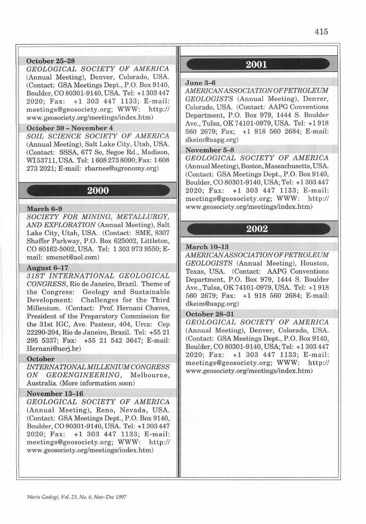
October 25-28 GEOLOGICAL SOCIETY OF AMERICA (Annual Meeting), Denver, Colorado, USA. (Contact: GSA Meetings Dept., P.O. Box 9140, Boulder, CO 80301-9140, USA. Tel: +1303 447 2020; Fax: +1 303 447 1133; E-mail: [email protected]; WWW: http:// www.geosociety.org/meetings/index.htm)
October 30 - November 4 SOIL SCIENCE SOCIETY OF AMERICA (Annual Meeting), Salt Lake City, Utah, USA. (Contact: SSSA, 677 So, Segoe Rd., Madison, WI 53711, USA. Tel: 16082738090; Fax: 1608 2732021; E-mail: [email protected])
2000
March 6-9 SOCIETY FOR MINING, METALLURGY, AND EXPLORATION (Annual Meeting), Salt Lake City, Utah, USA. (Contact: SME, 8307 Shaffer Parkway, P.O. Box 625002, Littleton, CO 80162-5002, USA. Tel: 1 303 973 9550' E-mail: [email protected]) ,
August 6-17 31ST INTERNATIONAL GEOLOGICAL CONGRESS, Rio de Janeiro, Brazil. Theme of the Congress: Geology and Sustainable Development: Challenges for the Third Millenium. (Contact: Prof. Hernani Chaves President of the Preparatory Commission fo; the 31st IGC, Ave. Pasteur, 404, Urca: Cep 22290-204, Rio de Janeiro, Brazil. Tel: +5521 295 5337; Fax: +55 21 542 3647; E-mail: [email protected])
October INTERNATIONALMILLENIUM CONGRESS ON GEOENGINEERING, Melbourne, Australia. (More information soon)
November 13-16 GEOLOGICAL SOCIETY OF AMERICA (Annual Meeting), Reno, Nevada, USA. (Contact: GSA Meetings Dept., P.O. Box 9140, Boulder, CO 80301-9140, USA. Tel: +1303447 2020; Fax: +1 303 447 1133; E -mail: [email protected]; WWW: http: // www.geosociety.org/meetings/index.htm)
Warta Geologi, Vol. 23, No.6, Nov-Dec 1997
415
2001
June 3--6 AMERICAN ASSOCIATION OF PETROLEUM GEOLOGISTS (Annual Meeting), Denver, Colorado, USA. (Contact: AAPG Conventions Department, P.O. Box 979, 1444 S. Boulder Ave. , Tulsa, OK 74101-0979, USA. Tel: +1918 560 2679; Fax; +1 918 560 2684; E-mail: [email protected])
November 5-8 GEOLOGICAL SOCIETY OF AMERICA (Annual Meeting), Boston, Massachusetts, USA. (Contact: GSA Meetings Dept., P.O. Box 9140, Boulder, CO 80301-9140, USA; Tel: +1303447 2020; Fax: +1 303 447 1133 ; E -mail: [email protected]; WWW: http:// www.geosociety.org/meetings/index.htm)
2002
March 10-13 AMERICAN ASSOCIATION OFPETR OLE UM GEOLOGISTS (Annual Meeting), Houston, Texas, USA. (Contact: AAPG Conventions Department, P.O. Box 979, 1444 S. Boulder Ave., Tulsa, OK 74101-0979, USA. Tel: +1918 560 2679; Fax: +1 918 560 2684; E-mail: [email protected])
October 28-31 GEOLOGICAL SOCIETY OF AMERICA (Annual Meeting), Denver, Colorado, USA. (Contact: GSA Meetings Dept., P .O. Box 9140, Boulder, CO 80301-9140, USA; Tel: +1303447 2020; Fax: +1 303 447 1133; E-mail: meetings@geosociety .org; WWW: http:// www.geosociety.org/meetings/index.htm)

Common Rocks of Malaysia A full colour poster illustrating 28 common rocks of Malaysia. With concise description of the features and characteristics of each rock type including common textures of igneous, sedimentary and metamorphic rocks.
Laminated
Size: 94 cm x 66 cm (42" x 26")
Price: Student members Members Non-members
RM7.00 (one copy per member, subsequent copies RMIO.OO each) RMS.OO (one copy per member, subsequent copies RMIO.OO each) RMIO.OO per copy
COMMON ROCK
Cheques, Money Orders or Bank Drafts must accompany all orders. Orders will be invoiced for postage and bank charges. Orders should be addressed to:
ORDERS The Hon. Assistant Secretary GEOLOGICAL SOCIETY OF MALAYSIA c/o Dept. of Geology, University of Malaya 50603 Kuala Lumpur, MALAYSIA

G~olo,gical Evolution :of " South-East Asia '
CHARLES s. HUTCEUSON
SPECIAL LOW-PRICED SOFT-COVER EDITION LIMITED STOCK! GET YOUR COPY NOW!
Member RM50.00 PRICE: Non-Member : RMIOO.OO
Student Member : RM30.00 Cheques, Money Orders or Bank Drafts must accompany all orders. Orders will be invoiced for postage and bank charges. Orders should be addressed to:
The Hon. Assistant Secretary GEOLOGICAL SOCIETY OF MALAYSIA c 10 Dept. of Geology, University of Malaya 50603 Kuala Lumpur, MALAYSIA

GEOLOGICAL SOCIETY OF MALAYSIA PUBLICATIONS BULLETIN OF THE GEOLOGICAL SOCIETY OF MALAYSIA
W ARTA GEOLOGI - NEWSLETTER OF THE GEOLOGICAL SOCIETY OF MALAYSIA
RATES:
Inside full page per issue Inside half page per issue Inside full page for 6 issues Inside half page for 6 issues
WARTA GEOLOGI Format: 20 cm x 28 cm
Black & White
RM300 RM200
RMl,500 RMl,OOO
Colour
RM600 RM500
RM3,000 RM2,500
BULLETIN Format: 20 em x 28 cm
Black & White
RMl,OOO RM500
Colour
RMl,500 RM800
Artwork and positive films or slides (for colour or black & white) should be supplied by the advertiser.
Please send the completed form below together with remittance payable to "Geological Society of Malaysia" to
The Editor, Geological Society of Malaysia do Dept. of Geology, University of Malaya, 50603 Kuala Lumpur, Malaysia.
For further information, please ring 603-7577036 or fax 603-7563900.
~-------------------------------------The Editor, Geological Society of Malaysia do Dept. of Geology, University of Malaya, 50603 Kuala Lumpur.
We would like to take up advertising space in WARTA GEOLOGIIBULLETIN in the form (please tick as appropriate):
WARTA GEOLOGI BULLETIN Black & White Colour Black & White Colour
Inside full page one issue D one issue D one issue D one issue D six issues D six issue D issues D issues D
Inside half page one issue D one issue D one issue D one issue D six issues D six issue D issues D issues D
ArtworkIPositive filmlslide* enclosed D not enclosed D Company ............................................................................................................................................ .
Address ............................................................................................................................................... .
Enclosed cheque/money orderlbank draft* ....................................... for RM ......................................... .
Person to be contacted .................................................................. Tel:
Designation ................................................................................. Fax:
* Please delete as appropriate. Signature ...................................... .

G:EOL!OGIQAJ.;'~SOCI;ETY ·O·F'·M'A:L.AYSIA PUa't-I!CAtIONS .-:;: . ,'- "-~. ',-; - - <' ".,?"
Bulletin 1 (Feb 1968). 79 p. Studies in Malaysian Geology. Edned by P.H. Stauffer. A conection of papers presented at a meeting of the Geological Society on 31 st JanuarY 1967. Out of Stock.
Bulletin 2 (Dec 1968). 152 p. Bibli()graphy and Index of the Geology of West Malaysia and Singapore by D.J. Gobbett. Price: RM5.00.
Bulletin 3 (Mar 1970). 146 p. Papers in Geomorpholog)' and Stratigr~hy (with Bibliography supplement). Edited by PH Stauffer. Price: RM5.00.
Bulletin 4 (Jun 1971). 100p. Papers in P~logy, Structure and Economic Geology. Edited by P.H. Stauffer. Pnce: RM5.00.
Bulletin 5 (~eb 19?3). 70 p. The Search for Tungsten Deposns by K.F.G. Hosking. Pnce: RM5.00.
Bulletin 6 (JuI1973). 334 p. Proceedings, Regional Conference on the Geology of $outheast Asia. A ~lIection of papers, Kuala Lumpur, March, 1972. Edited by B.K. Tan. Pnce: RM5.00.
Bulletin 7 (Jun ~ 974). 138 p. A collection of papers on geology. Edned by B.K. Tan. Pnce: I=!M5.00.
Bulletin 8 (Dec 1~77). 158 p. A collection of papers on geology. Edned by T.T. Khoo. Pnce: RM5.00.
Bulletin 9 (Nov 1977). 277 p. The relations between grannoids and associated ore deposns of the Circum-Pacific region. A collection of papers presented at the IGCP Circum-Pacific Plutonism Project Fifth Meeting. 12-13 November 1975, Kuala Lumpur. Edited by J.A. Roddick & T.T. Khoo. Out of stock.
Bulletin 10 (Dec 1978). 95 p. A collection of papers on the geology of Southeast Asia. Edned by CH Yeap. Out of stock.
Bulletin 11 (Dec 1979). 393p. Geology of Tin DePQsns. A collection of papers presented at the Intemational Symposium of 'Geology of Tin DePQsns', 23-25 March 1978, Kuala Lumpur. Edned by CH Yeap. Price: RM20.00.
Bulletin 12 (Aug 1980). 86 p. A collection of papers on geology. Edned by G.H. Teh. Out of stock.
Bulletin 13 fDec 198Q). 111 ~. A collection. of papers on geology of Malaysia and Thailand. Edited by G.H. Teh. Pnce: RM5.00.
Bulletin 14 (Dec 1981). 151 p. A collection of papers on geology of Southeast Asia. Edned by G.H. Teh. Out of stock.
Bulletin15(DE191982). 151 p. A collection of papers on geology. EdnedbyG.H. Teh. Pnce: RM10.00.
Bulletin 16 (Dec 1983). 239 p. A collection of papers on geology. Edned by G.H. Teh. Price: RM10.00.
Bulletin17(DE191984). 371 p. A collection of papers on geology. EdnedbyG.H. Teh. Pnce: . .RM10.00.
Bulletin 18 (Nov 1985). 209 p. Speciallssue on Petroleum Geology. Edned by G.H. Teh & S. Paramananthan. Price: RM15.00.
Bulletins 19 (Apr 1986) & 20 (Aug 1986). GEOSEA V Proceedings Vols. I & II, Fifth Flegional Congress on Geofogy, Mineral and Energy Resources of Southeast Asia, Kuala Lumpur, 9-13 April 1984. Edned oy G.H. Teh & S. Paramananthan. Price for both Bulletins 19 & 20: Members: RM30.00; Non-Members: RM60.00.
Bulletin 2~ (Dec 1987). 271 p.. S~alissue on Petroleum Geology Vol. II. Edited by G.H.'reh. Pnce: RM20.00.
Bulletin ~ (Dec 1988). 272 p.. S~alissue on Petroleum Geology Vol. III. Edited by G.H. Teh. Pnce: RM20.00.
Bulletin 23 fAug 1989). 215 p. A 9Qllection of ~ers o~ the geology of Malaysia, Thailand and Surma. Edited by G.H. Teh. Pnce: RM10.00.
Bulletin 24 (~1989). 199 p. A collection of~rs presented at.GSM Annual GeolOgical Coriference 1987 and 1988. Edifedb}iG.H. Teh. Pnce: RM10.oo.
Bulletin ~ (Dec 1989). 161 p.. S~alissue on Petroleum Geology Vol. IV. Edited by G.H. Teh. Pnce: RM20.00.
Bulletin 26 (Apr 1990). 223 p. A collection of papers presented at.GSM Annual GeologicaiCorifererloe1989andothers. EditedbYG.H.Teh. Pnce: RM10.oo.
Bulletin 2! (Nov 1990). 292 p.. Special Issue on Petroleum Geology Vol. V. Edited by G.H. 'reh. Pnce: RM20.00.
Bulletin 2!1 (Nov 1991). 292 p.. S~iallssue on Petroleum Geology Vol. VI. Edited by G.H. Teh. prtce: RM20.00.
Bulletin 29 (J~11991). 255 p. A collection of papers presented at .GSM Annual GeolOgicalCor1ference1990andolhers. EditedbYG.H. Teh. Pnce: RM10.oo.
Bulletin 30 (Apr 1992). 90 p. Annotated bibliography of the geology of the South China Sea and adjacent parts of Bomeo by N.S. Haile. Edned by G.H. Teh. Price: RM10.00
Bulletin 31 (J~11992). 176 p. A collection of papers presented at .GSM Annual GeolOgical COIiferen<jj 1991 andothers. EditedbYG.H. T eh. Pnce: RM10.oo.
Bulletin 32 (Nov 1992). 283p. Special Issue on Petroleum Geology Vol. VII. Edned by G.H. 'reh. Price RM30.00.
Bulletin 33 (Nov 1993). 419 p. Proceedings Symposium on Tectonic Framework
and Energ), Res~urcesofthe Westem Margin of the Pacific Basin. Edned by G.H. Teh. Pnce: RM4O.00.
Bulletin 34 (Dec 1993). 181p. Bibliography and Index - Publications of the Geological Socl~ty of Malaysia 1967-1993. Compiled by T.F. Ng. Edned by G.H. Teh. Pnce: RM20.00.
Bulletin 35 (JuI1994). 174 p. A collection of papers presented at GSM Annual Geofogical COnference 1992 & 1993 and others. Edned by G.H. Teh. Price: RM20.00.
Bulletin 3~ (Dec 1994). 186 p: S~ial issue on Petroleum Geology Vol. VIII. Edited by G.H.leh. Pnce: RM50.00.
Field Guide 1 (1973). 40 p. A 7-day one thousand mile, geological excursion in Central and South Malaya (West Malaysia and Singapore). By C.S. Hutchison. Out of stock.
Abstracts of papers (1972). Regional Conference on the Geology of Southeast Asia, Kuala l:Umpur, 1972 .. 64P: 8 figs, 3 tables, many extended abstracts. Edited by N.S. Hade. Pnce: RM2.00.
Proceedings of the Workshop on Stratigraphic Correlation of Thailand and Ma18YSi~ Vol. 1. (19~). 383 p. Technical Papers. Price: Member: RM5.00, Non-member. RM15.00.
WARTA GEOLOGI (Newsletter of the Geological Society of Malaysia). Price: RM5.00 per bimonthly issue from July 1966.
Geological Evolution of Southeast Asia (1996) (Reprinted Edition) by C.S. ~utchison. 368p. Price: Member: RM50.dO;Non-member: RM100.00; Student: RM30.00.
Common Rocks of Malaysia (Colour Poster). Price: Member: RM8.00; Nonmember: RM10.00; Student: RM7.00.
Malaysian Stratigraphic Guide (Dec 1997). 30 p. Price: Member: RM5.00; Non-Member: RM10.00; Student Member: RM2.00.
PACKAGE DEAL A: General Geology/Malaysian Geology Bulletins 3, 4, 7, 15, 16, 17,24,26,29,31 (10 books) Member: RM60.00 Student Member: RM40.00 Non-member: RM75.00 Student Non-member: RM50.00
PACKAGE DEAL B: Bibliography Bulletins 2, 30, 34 (3 books) Member: RM20.00 Student Member: RM10.00 Non-member: RM25.00 Student Non-member: RM15.00
PACKAGE DEAL C: Southeast Asia Bulletins 6,13,19 & 20, 23, 33, Strati. Correl. (7 books) Member: RM60.00 Student Member: RM40.00 Non-member: RM100.00 Student Non-member: RM50.00
PACKAGE DEAL D: Petroleum Geology Bulletins 18, 21, 22, 25, 27, 28,"32 (7 books) Member: RM120.00 Student Member: RM80.00 Non-member: RM150.00 Student Non-member: RM100.00
PACKAGE DEAL E: Economic Geology Bulletins 5, 11 (2 books) Member: RM15.00 Student Member: 5.00 Non-member: RM20.00 Student Non-member: 10.00
PACKAGE DEAL 1: Bulletins 2, 3, 4, 5, 6, 7, 8, 11 (8 books) Member: RM30.00 Stuaent Member: flM15.00 Non-member: RM40.00 Student Non-member: RM25.00
PACKAGE DEAL 2: Bulletins 13, 15, 1~ 17, 18 (5 books) Member: RM30.00 ::student Member: RM15.00 Non-member: RM40.00 Student Non-member: RM25.00
PACKAGE DEAL 3: Bulletins 19, 20, Strati. Correl. (3 books) Member: RM30.00 Student Member: RM20.00 Non-member: RM60.00 Student Non-member: RM30.00
PACKAGE DEAL 4: Bulletins 21, 22, 23 24,25 (5 books) Member: RM40.00 Student Member: RM20.00 Non-member: RM60.00 Student Non-member: RM30.00
PACKAGE DEAL 5: Bulletins 26, 27, ~ 29, 30 (5 books) Member: RM40.00 ::stuaent Member: RM20.00 Non-member: RM60.00 Student Non-member: RM30.00
PACKAGE DEAL 6: Bulletins 31, 32, ~ 34,35 (5 books) Member: RM60.00 ::student Member: RM30.00 Non-member: RM100.00 Student Non-member: RM40.00
All prices guoted are not inclusive of postage. Please write in for details on postage. Allow 8-10 weeks for delivery. For orders, please write to the Society and you will be invoiced. Cheques, money orders or bank drafts must accompany all orders. Orders should be addressed to:
The Hon. Assistant Secretary, Geological Society of Malaysia, c/o Dept. of Geology, University of Malaya,
50603 Kuala liimpur, MAlAYSIA. TEL: 603-7577036, FAX: 603-7563900, E-MAIL: [email protected]
Effective September 1997

ORDER FORM
GEOLOGICAL SOCIETY OF MALAYSIA PUBLICATION
The Assistant Secretary, Geological Society of Malaysia, c/o Department of Geology, University of Malaya, 50603 Kuala Lumpur, MALAYSIA
Dear Sir,
Date: ....................... .
Please sendmethefollowingpublications. I enclose US$IRM* .......................... . in cheque/money orderlbank draft. *
Item No. of Copies Price
------------------------------------- --------------------------------------------- --------------------------------------
----------------------- --
*Delete where applicable
Sub-Total
Total
Signature: __________________________________ .
Please mail to: ______________________________________________________ -----------------------------------(Please print) --------------------- ----------------------------------------
------------------------------------------------------------- ----
GEOLOGICAL SOCIETY OF MALAYSIA PUBLICATIONS
General Information Papers should be as concise as possible. However, there is no fixed limit as to the length and number of illustrations. Normally, the whole paper should not exceed 30 printed pages. The page size will be 204 x 280 mm (8 x 11 inches).
The final decision regarding the size of the illustrations, sections of the text to be in small type and other matters relating to printing rests with the Editor.
The final decision of any paper submitted for publication rests with the Editor who is aided by a Special Editorial Advisory Board. The Editor may send any paper submitted for review by one or more reviewers. Authors can also include other reviewers' comments of their papers. Scripts of papers found to be unsuitable for publication may not be returned to the authors but reasons for the rejection will be given. The authors of papers found to be unsuitable for publication may appeal only to be Editorforreconsideration if they do not agree with the reasons for rejection. The Editor will consider the appeal together with the Special Editorial Advisory Board.
Unless with the consent of the Editor, papers which have been published before should not be submitted for consideration.
Authors must agree not to publish elsewhere a paper submitted and accepted.
Authors alone are responsible for the facts and opinions given in their papers and for the correctness of references etc. One set of proofs will be sent to the author (if time permits), to be checked for printer's errors. In the case of two or more authors, please indicate to whom the proofs should be sent.
Twenty-five reprints of each article published are supplied free-of-charge. Additional reprints can be ordered on a reprint order form, which is included with the proofs.
Correspondence: All papers should be submitted to
The Editor (Dr. Teh Guan Hoe) Geological Society of Malaysia
c/o Geology Department University of Malaya 50603 Kuala Lumpur
MALAYSIA Tel: (603) 7577036 Fax: (603) 7563900
'eiip'~~~iB~IlJS; Scripts must be written in Bahasa Malaysia (Malay) or English.
Two copies of the text and illustrations must be submitted. The scripts must be typewritten double-spaced on paper not exceeding 210 x 297 mm (or 8.27 x 11.69 inches, A4 size). One side of the page must only be typed on.
Figure captions must be typed on a separate sheet of paper. The captions must not be drafted on the figures. The figure number should be marked in pencil on the margin or reverse side.
Original maps and illustrations or as glossy prints should ideally be submitted with sufficiently bold and large lettering to permit reduction to 18 x 25 em: fold-outs and large maps will be considered only under special circumstances.
Photographs should be of good quality, sharp and with contrast. For each photograph, submit two glossy prints, at least 8 x 12.5 cm and preferably larger. Use of metric system of measurements (SI) is strongly urged wherever possible.
An abstract in English which is concise and informative is required for each paper.
References cited in the text should be listed at the end of the paper and arranged in alphabetical order and typed double-spaced. The name of the book or journal must be in italics. The references should be quoted in the following manner:
HAMILTON, W., 1979. Tectonics of the Indonesian region. U.S. Geological Survey Professional Paper 1078, 345p.
HOSKING, K.F.G., 1973. Primary mineral deposits. In Gobbett, D.J. and Hutchison, C.S. (Eds.), Geology of the Malay Peninsula (West Malaysia and Singapore). Wiley-Interscience. New York, 335-390.
HUTCmsoN, C.S., 1989. Geological Evolution of South-east Asia. Clarendon Press, Oxford. 368p.
SUNTHARALINGAM, T., 1968. Upper Paleozoic stratigraphy of the area west ofKampar, Perak. Geol. Soc. Malaysia Bull. 1, 1-15.
TAYLOR, B., AND HAYES, D.E., 1980. The tectonic evolution of the South China Sea basin. In: D.E. Hayes (Ed.),The Tectonic and Geologic Evolution of Southeast Asian Seaandlslands,Part2.Am. Geophy. UnionMonograph 23,89-104.
Submission of electronic text. In order to publish the paper as quickly as possible after acceptance, authors are requested to submit the final text also on a 3.5" diskette. Both Macintosh and PC (DOSlWindows) platforms are supported. Main text, tables and illustrations should be stored in separate files with clearly identifiable names. Text made with most word processors can be readily processed but authors are advised to provide an additional copy of the text file in ASCII format. Preferred format for illustration is Encapsulated PostScript (EPS) but authors may submit graphic files in their native form. It is essential that the name and version of sof'twares used is clearly indicated. The final manuscript may contain parts (e.g. formulae, complex tables) or last-minute corrections which are not included in the electronic text on the diskette; however, this should be clearly marked in an additional hardcopy of the manuscript. Authors are encouraged to ensure that apart from any such small last-minute corrections, the disk version and the hardcopy must be identical. Discrepancies can lead to proofs of the wrong version being made.

Ni~
siberu~ SUMATRA
100° E
AMBODIAc-.1 \ VIETNAM
.-,~ /""
ala Terengganu
~ingga
O Singkep
200 Ian
LAUT CHINA SELATAN (South China Sea)
o Natuna
Belitung
110° E
NEGERI-NEGERI MALAYSIA (STATES OF MALAYSIA)
1 PERLIS 8 PAHANG 2 KEDAH 9 NEGERI SEMBI LAN 3 PULAU PI NANG 10 MELAKA 4 PERAK 11 JOHOR 5 KELANTAN 12 SABAH 6 TERENGGANU 13 SARAWAK 7 SELANGOR
KALIMANTAN
s