ngu report 2016 · ngu report 2016.001 25th seminar on hydrogeology and the environment february...
TRANSCRIPT

NGU REPORT2016.001
25th Seminar on Hydrogeology and theEnvironment
February 3-4, 2016Urban Hydrogeology


CONTENTS
Land subsidence monitoring in Rafsanjan plain, southeast Iran from multi-sensor InSAR data
Groundwater as a resource for heating and cooling purposes
Bryggen World Heritage Site - Restoring the water balance in order to counteract subsidence and decay
The future of urban hydrogeology:
Notes
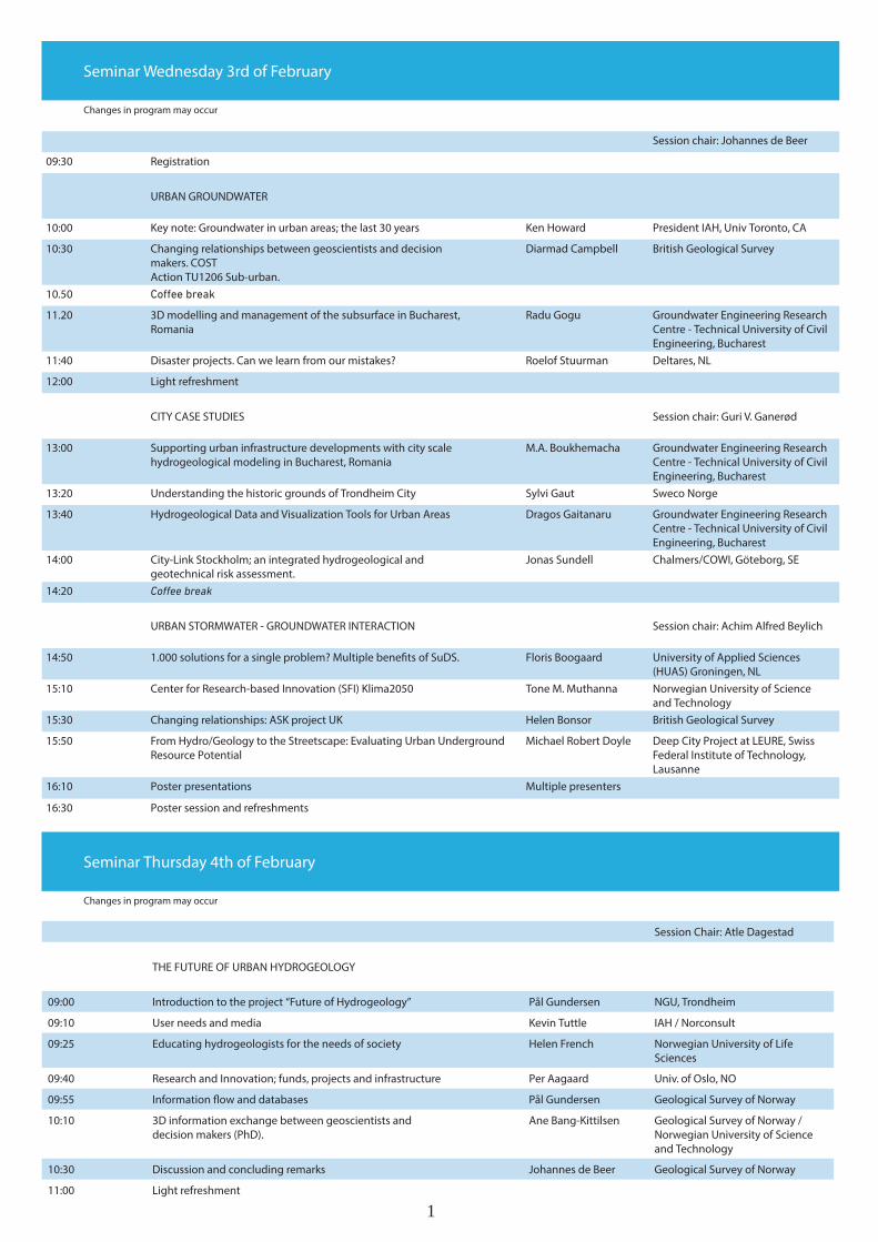
Session chair: Johannes de Beer
09:30 Registration
URBAN GROUNDWATER
10:00 Key note: Groundwater in urban areas; the last 30 years Ken Howard President IAH, Univ Toronto, CA
10:30 Changing relationships between geoscientists and decision makers. COST Action TU1206 Sub-urban.
Diarmad Campbell British Geological Survey
10.50
11.20 3D modelling and management of the subsurface in Bucharest, Romania
Radu Gogu Groundwater Engineering Research Centre - Technical University of Civil Engineering, Bucharest
11:40 Disaster projects. Can we learn from our mistakes? Roelof Stuurman Deltares, NL
12:00 Light refreshment
CITY CASE STUDIES Session chair: Guri V. Ganerød
13:00 Supporting urban infrastructure developments with city scale hydrogeological modeling in Bucharest, Romania
M.A. Boukhemacha Groundwater Engineering Research Centre - Technical University of Civil Engineering, Bucharest
13:20 Understanding the historic grounds of Trondheim City Sylvi Gaut Sweco Norge
13:40 Hydrogeological Data and Visualization Tools for Urban Areas Dragos Gaitanaru Groundwater Engineering Research Centre - Technical University of Civil Engineering, Bucharest
14:00 City-Link Stockholm; an integrated hydrogeological and geotechnical risk assessment.
Jonas Sundell Chalmers/COWI, Göteborg, SE
14:20
URBAN STORMWATER - GROUNDWATER INTERACTION Session chair: Achim Alfred Beylich
14:50 1.000 solutions for a single problem? Multiple benefits of SuDS. Floris Boogaard University of Applied Sciences (HUAS) Groningen, NL
15:10 Center for Research-based Innovation (SFI) Klima2050 Tone M. Muthanna Norwegian University of Science and Technology
15:30 Changing relationships: ASK project UK Helen Bonsor British Geological Survey
15:50 From Hydro/Geology to the Streetscape: Evaluating Urban Underground Resource Potential
Michael Robert Doyle Deep City Project at LEURE, Swiss Federal Institute of Technology, Lausanne
16:10 Poster presentations Multiple presenters
16:30 Poster session and refreshments
Changes in program may occur
Changes in program may occur
Seminar Wednesday 3rd of February
Seminar Thursday 4th of February
Session Chair: Atle Dagestad
THE FUTURE OF URBAN HYDROGEOLOGY
09:00 Introduction to the project “Future of Hydrogeology” Pål Gundersen NGU, Trondheim
09:10 User needs and media Kevin Tuttle IAH / Norconsult
09:25 Educating hydrogeologists for the needs of society Helen French Norwegian University of Life Sciences
09:40 Research and Innovation; funds, projects and infrastructure Per Aagaard Univ. of Oslo, NO
09:55 Information flow and databases Pål Gundersen Geological Survey of Norway
10:10 3D information exchange between geoscientists and decision makers (PhD).
Ane Bang-Kittilsen Geological Survey of Norway / Norwegian University of Science and Technology
10:30 Discussion and concluding remarks Johannes de Beer Geological Survey of Norway
11:00 Light refreshment
1
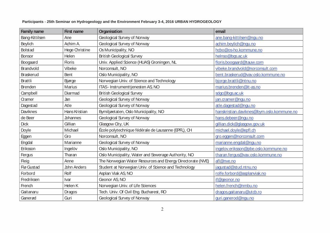
Participants 25th Seminar on Hydrogeology and the Environment February 3-4, 2016 URBAN HYDROGEOLOGY
Family name First name Organisation email Bang-Kittilsen Ane Geological Survey of Norway [email protected]
Beylich Achim A. Geological Survey of Norway [email protected]
Bolstad Hege Christine Os Municipality, NO [email protected]
Bonsor Helen British Geological Survey [email protected]
Boogaard Floris Univ. Applied Science (HUAS) Groningen, NL [email protected]
Brandvold Vibeke Norconsult, NO [email protected]
Braskerud Bent Oslo Municipality, NO [email protected]
Brattli Bjørge Norwegian Univ. of Science and Technology [email protected]
Brenden Marius ITAS - Instrumenttjenesten AS, NO [email protected]
Campbell Diarmad British Geological Survey [email protected]
Cramer Jan Geological Survey of Norway [email protected]
Dagestad Atle Geological Survey of Norway [email protected]
Daviknes Hans Kristian Bymiljøetaten, Oslo Municipality, NO [email protected]
de Beer Johannes Geological Survey of Norway [email protected]
Dick Gillian Glasgow City, UK [email protected]
Doyle Michael École polytechnique fédérale de Lausanne (EPFL), CH [email protected]
Eggen Gro Norconsult, NO [email protected]
Engdal Marianne Geological Survey of Norway [email protected]
Eriksson Ingelöv Oslo Municipality, NO [email protected]
Fergus Tharan Oslo Municipality, Water and Sewerage Authority, NO [email protected]
Fleig Anne The Norwegian Water Resources and Energy Directorate (NVE) [email protected]
Flø Gustad John Anders Student at Norwegian Univ. of Science and Technology [email protected]
Forbord Rolf Asplan Viak AS, NO [email protected]
Fredriksen Ivar Geonor AS, NO [email protected]
French Helen K Norwegian Univ. of Life Sciences [email protected]
Gaitanaru Dragos Tech. Univ. Of Civil Eng. Bucharest, RO [email protected]
Ganerød Guri Geological Survey of Norway [email protected]

Family name First name Organisation email Gaut Sylvi SWECO, Trondheim, NO [email protected]
Gjengedal Sondre PhD student at Norwegian Univ. of Science and Technology [email protected]
Gogu Constantin Radu Tech. Univ. Of Civil Eng. Bucharest, RO [email protected]
Gundersen Pål Geological Survey of Norway [email protected]
Hagen Unni Multiconsult ASA, Bergen, NO [email protected]
Haukedal Joakim Student at Norwegian Univ. of Science and Technology [email protected]
Helgason Peder Multiconsult, NO [email protected]
Henriksen Helge Sogn & Fjordane University College [email protected]
Hilmo Bernt Olav Asplan Viak, Trondheim, NO [email protected]
Howard Ken Univ Tronto, CA, IAH president [email protected]
Ihler Harald SSAB Svensk Stål AS, NO [email protected]
Jensen Jann Atle Multiconsult ASA, Bergen, NO [email protected]
Jensen Niels-Peter I-GIS A/S, DK [email protected]
Jæger Øystein Geological Survey of Norway [email protected]
Jørlo Haugerud Haakon Student at Norwegian Univ. of Science and Technology [email protected]
Kvitsand Hanne Asplan Viak AS, NO [email protected]
Lawrence David British Geological Survey [email protected]
Linderberg Johan VandCenter Syd, DK [email protected]
Lysen Svein Ragnar Multiconsult ASA, NO [email protected]
Mielby Susie Geological Survey of Denmark and Greenland [email protected]
Moen Kjersti Implenia, NO [email protected]
Muthanna Tone Norwegian Univ. of Science and Technology [email protected]
Nygård Ingvild Haneset Student at Norwegian Univ. of Science and Technology [email protected]
Petersén Anna Norwegian Instituet for Cultural Heritage Research [email protected]
Ramstad Randi Kalskin Asplan Viak / Norwegian Univ. of Science and Technology [email protected]
Riise Mari Helen Asplan Viak, Trondheim, NO [email protected]
Rosén Lars Chalmers Univ. of Technology [email protected]
Sandbakken Marit Eline Student at Norwegian Univ. of Science and Technology [email protected]
Seither Anna Geological Survey of Norway [email protected]

Family name First name Organisation email Serbulea Manole Stelian Tech. Univ. of Civil Eng. Bucharest, RO Skei Silje Øren Student at Norwegian Univ. of Science and Technology [email protected]
Skoglund Rannveig Øvrevik Dep. Geography, Univ. of Bergen, NO [email protected]
Sognnæs Guri Student at Univ. of Bergen, NO [email protected]
Staubo Munthe-Kaas Nille Ragnhild Implenia, NO [email protected]
Storbekkrønning Gunnhild Solli PhD student at Faculty of Law, Univ. of Oslo [email protected]
Stormoen Martin Austin Norwegian government’s agency for railway services (JBV) [email protected]
Storrø Gaute Geological Survey of Norway [email protected]
Stuurman Roelof Deltares, NL [email protected]
Sundell Jonas Chalmers Univ. of Technology / COWI AB, SE [email protected]
Sæther Ola M Geological Survey of Norway [email protected]
Sørlie Jan Erik Hydro Geo Service AS, NO [email protected]
Tuttle Kevin J. Norconsult, NO [email protected]
van Campenhout Ignace Rotterdam City, NL [email protected]
Vorenhout Michel MVH Consult, NO [email protected]
Wakker Joyce Norconsult, Bergen, NO [email protected]
Aagaard Per Univ. of Oslo, NO [email protected]
PRESENTATIONS February 3rd
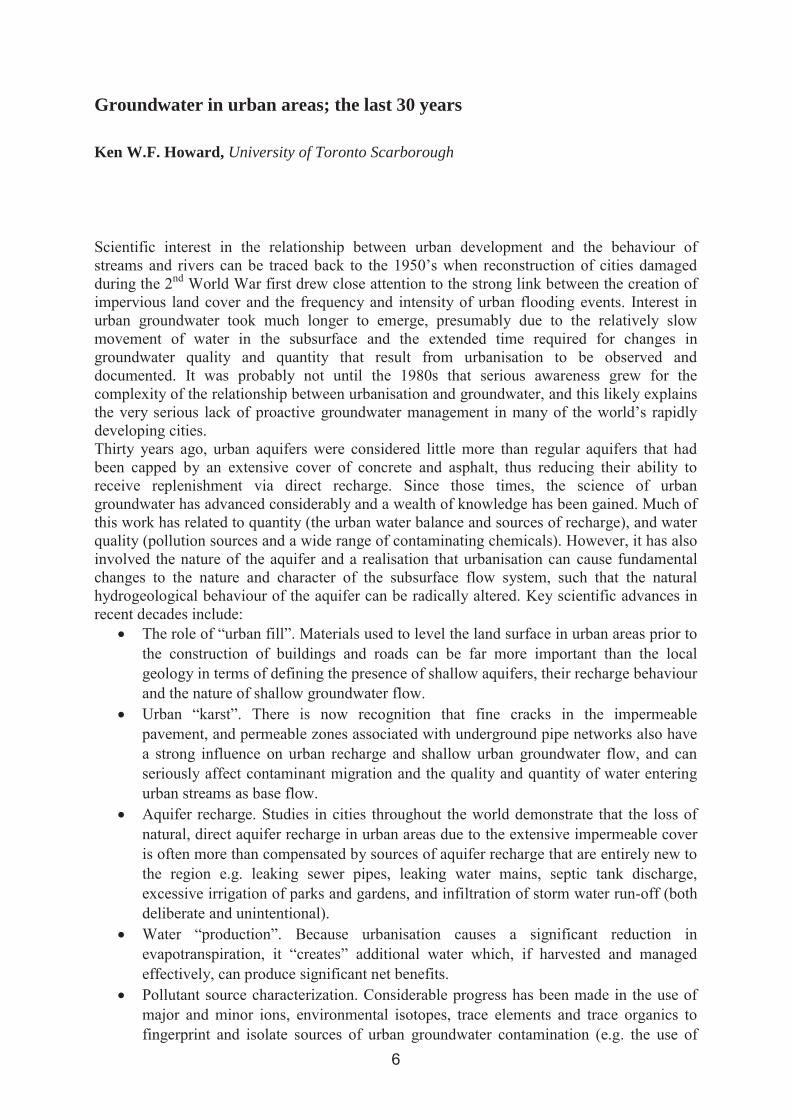
Groundwater in urban areas; the last 30 years
Ken W.F. Howard, University of Toronto Scarborough

Changing relationships between geoscientists and decision-makers - COST Action (TU1206) SUB-URBAN
Diarmad Campbell 1, Johannes de Beer 2, Helen Bonsor1, Ignace van Campenhout3,Susie Mielby4, Ingelov Eriksson5, Gillian Dick6, Michiel van der Meulen7, JeroenSchokker7, David Lawrence1, Guri Venvik Ganerod2, Rob van der Krogt7, Alex Donald8, Mario Bacic9, Grzegorz Ryzinski10 & Renate Taugs11
1 British Geological Survey, United Kingdom, 2Norwegian Geological Survey (NGU), Norway, 3City of Rotterdam, Netherlands, 4Geological Survey of Greenland and Denmark (GEUS), Denmark, 5 City of Oslo, Norway, 6Glasgow City Council, United Kingdom, 7Geological Survey of the Netherlands (TNO), Netherlands, 8 Geological Survey of Northern Ireland, United Kingdom, 9 University of Zagreb, Croatia, 10Polish Geological Institute, 11State Geological Survey of Hamburg (Germany)
, including its buried infrastructure, and development of comprehensive new subsurface planning and management systems.
3D modelling and management of the subsurface in Bucharest, Romania
Constantin Radu Gogu, Mohamed Amine Boukhemacha, Dragos Gaitanaru & Irina Serpescu
Groundwater Engineering Research Center, Technical University of Civil Engineering of Bucharest, Romania

A hydrogeological conceptual approach to study urban groundwater flow in Bucharest city, Romania
Sedimentary media analysis platform for groundwater modeling in urban areas
Urban groundwater modeling scenarios to simulate Bucharest city lake disturbance
Disaster projects. Can we learn from our mistakes?
Roelof Stuurman, Deltares, The Netherlands
Supporting urban infrastructure developments with city scale hydrogeological modeling in Bucharest, Romania
Mohamed Amine Boukhemacha, Constantin Radu Gogu, Irina Serpescu & Dragos Gaitanaru
Groundwater Engineering Research Center, Technical University of Civil Engineering of Bucharest, ROMANIA
References
Understanding the historic grounds of Trondheim City
Sylvi Gaut1 & Anna Petersén2
1Sweco Norge AS, 2NIKU
Background
Anthropogenic sediments in Trondheim
Observation wells and measurements of groundwater level
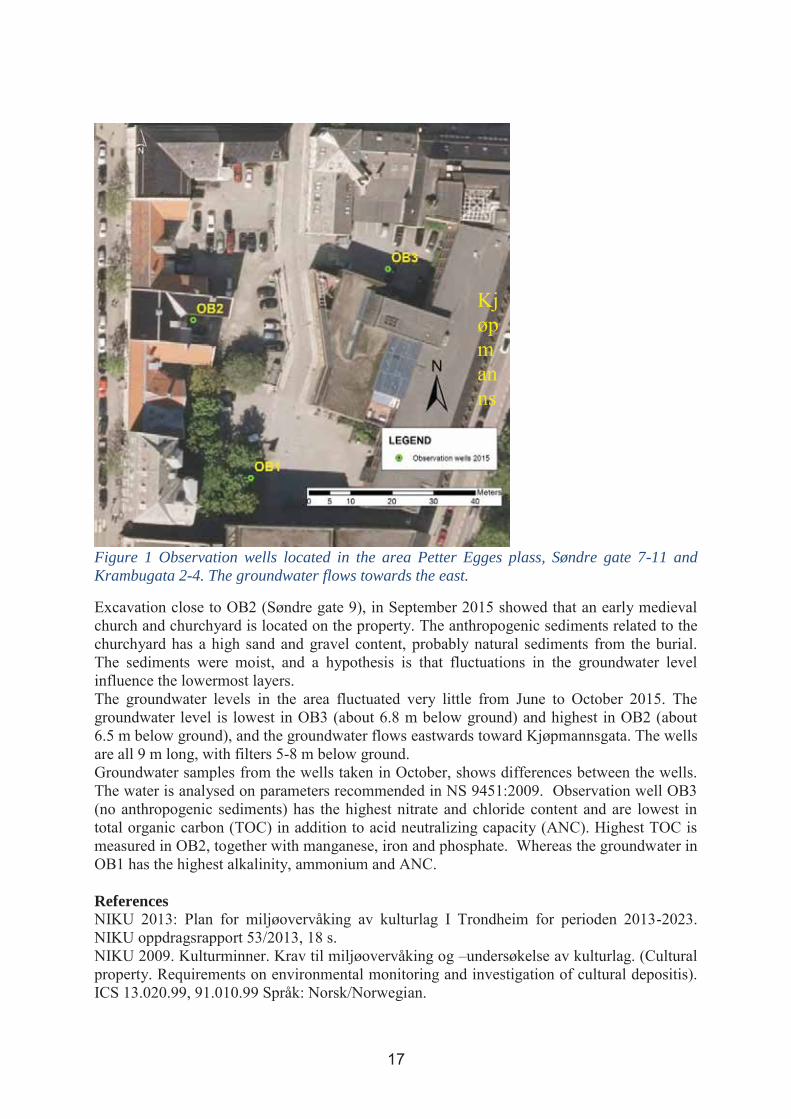
Figure 1 Observation wells located in the area Petter Egges plass, Søndre gate 7-11 and Krambugata 2-4. The groundwater flows towards the east.
References
Hydrogeological data and visualization tools for urban areas
Dragos Gaitanaru, Constantin Radu Gogu, Leonard Anghel, Mohamed Amine Boukhemacha & Irina Serpescu
Groundwater Engineering Research Center, Technical University of Civil Engineering of Bucharest, ROMANIA

City-Link Stockholm; an integrated hydrogeological and geotechnical risk assessment
Jonas Sundell1,2 & Lars Rosén1
1Department of Civil and Environmental Engineering, Chalmers University of Technology, Gothenburg, Sweden, 2COWI AB, Gothenburg, Sweden

A framework for risk assessment of groundwater drawdown induced subsidence
Engineering Geology
A PROBABILISTIC APPROACH FOR CALCULATION OF LAND SUBSIDENCE ON A MACRO-SCALE.
1000 solutions for a single problem? Multiple benefits of SuDS
Floris C. Boogaard, University of Applied Sciences (HUAS) Groningen, NL
Summary
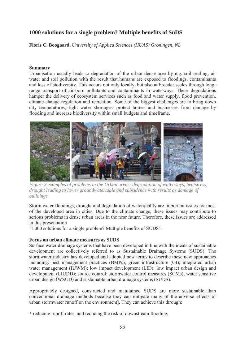
Figure 2 examples of problems in the Urban areas: degradation of waterways, heatstress, drought leading to lower groundwatertable and subsidence with results as damage of buildings
Focus on urban climate measures as SUDS
Research results quality issues
Research results quantity issues
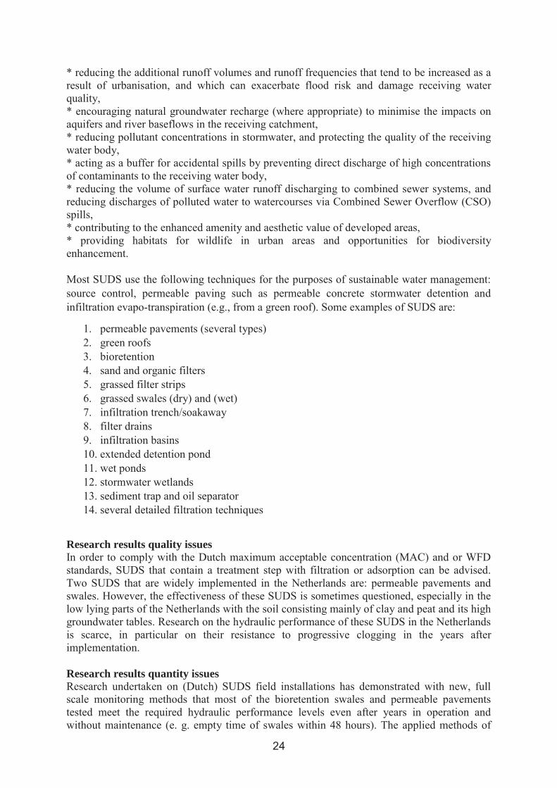
Full scale test at swale (left), full scale test at permeable pavement (right), Full scale test at watersquare (right).
CRI Klima 2050 | Risk reduction through climate adaptation of buildings and infrastructure
Tone Muthanna, Norwegian University of Science and Technology
Vision
GoalsKlima 2050
Motivation
Norwegian Government Pension Fund Global
A multidisciplinary approach
Klima 2050

References Building, construction and property industry's importance to
Norway - update 2013.
Changing relationships: Accessing Subsurface Knowledge (ASK) project UK
Helen Bonsor, H. British Geological Survey, United Kingdom
From Hydro/Geology to the Streetscape: Evaluating Urban Underground Resource Potential
Michael Robert Doyle
PhD candidate in Architecture and the Sciences of the City, Deep City Project, Laboratory for Environmental and Urban Economics (LEURE), Swiss Federal Institute of Technology, Lausanne
Advisors:
POSTERPRESENTATIONS
Land subsidence monitoring in Rafsanjan plain, southeast Iran from multi-sensor InSAR data
Roghayeh Shamshiri1, Mahdi Motagh2, Hossein Nahavandchi1, Hans-Ulrich Wetzel2, &Bahman Akbari3
1Department of Civil and Transport Engineering, Norwegian University of Science and Technology, 2GFZ German Research Centre for Geosciences, Potsdam, Germany, 3Forest, Range and Watershed (FRW) management organization of Iran
Groundwater as a resource for heating and cooling purposes
Marit E. Sandbakken
MSc student in Hydrogeology at Norwegian University of Science and Technology
Optimal Resource extraction of groundwater for heating and cooling in Melhus and Elverum municipalities (ORMEL)-
-0.025
-0.020
-0.015
-0.010
-0.005
0.000
��
��
���
���
���
���
���
���
���
���
���
���
������ �������� ������� ������� ������ ������� �������� ������� ������� ������� ������� ������� ������ �������
������������������ ��������������������
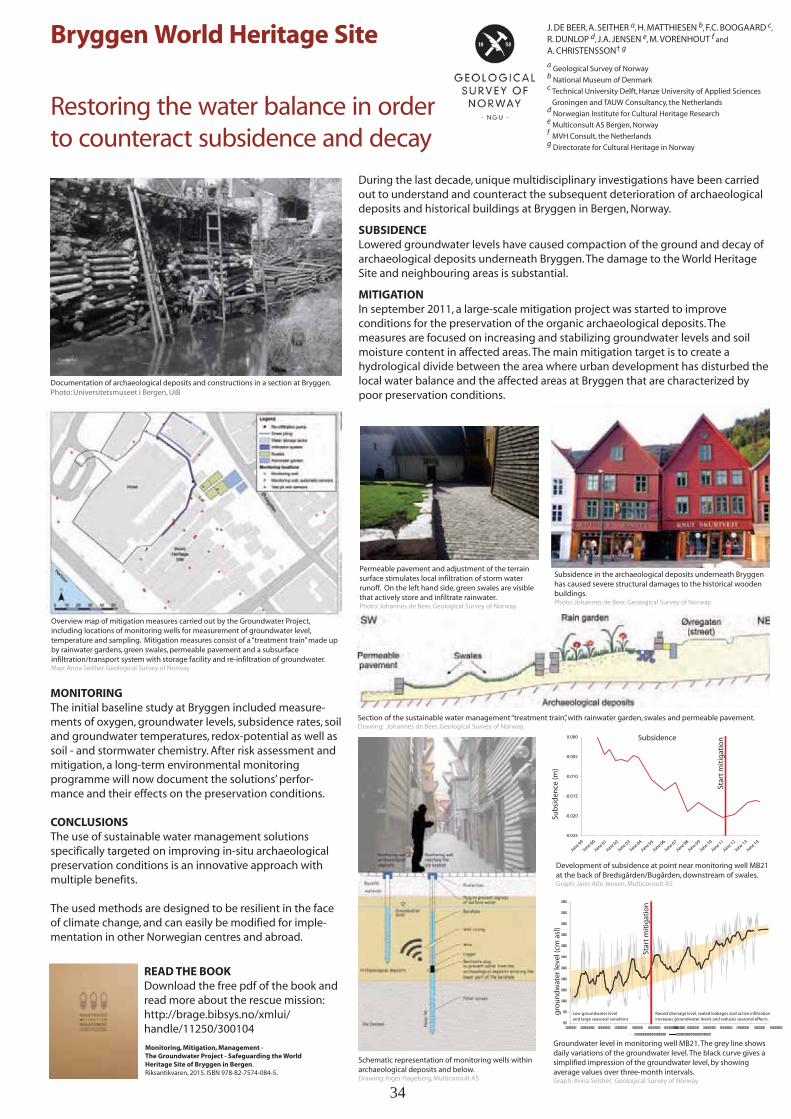
Bryggen World Heritage Site
Restoring the water balance in orderto counteract subsidence and decay
J. DE BEER, A. SEITHER a, H. MATTHIESEN b, F.C. BOOGAARD c,
R. DUNLOP d, J.A. JENSEN e, M. VORENHOUT f and
A. CHRISTENSSON† g
a Geological Survey of Norwayb National Museum of Denmarkc Technical University Delft, Hanze University of Applied Sciences
Groningen and TAUW Consultancy, the Netherlandsd Norwegian Institute for Cultural Heritage Researche Multiconsult AS Bergen, Norwayf MVH Consult, the Netherlandsg Directorate for Cultural Heritage in Norway
MONITORINGThe initial baseline study at Bryggen included measure-ments of oxygen, groundwater levels, subsidence rates, soil and groundwater temperatures, redox-potential as well as soil - and stormwater chemistry. After risk assessment and mitigation, a long-term environmental monitoring programme will now document the solutions’ perfor-mance and their effects on the preservation conditions.
CONCLUSIONSThe use of sustainable water management solutions specifically targeted on improving in-situ archaeological preservation conditions is an innovative approach with multiple benefits.
The used methods are designed to be resilient in the face of climate change, and can easily be modified for imple-mentation in other Norwegian centres and abroad.
During the last decade, unique multidisciplinary investigations have been carried out to understand and counteract the subsequent deterioration of archaeological deposits and historical buildings at Bryggen in Bergen, Norway.
SUBSIDENCELowered groundwater levels have caused compaction of the ground and decay of archaeological deposits underneath Bryggen. The damage to the World Heritage Site and neighbouring areas is substantial.
MITIGATIONIn september 2011, a large-scale mitigation project was started to improve conditions for the preservation of the organic archaeological deposits. The measures are focused on increasing and stabilizing groundwater levels and soil moisture content in affected areas. The main mitigation target is to create a hydrological divide between the area where urban development has disturbed the local water balance and the affected areas at Bryggen that are characterized by poor preservation conditions.
Groundwater level in monitoring well MB21. The grey line shows daily variations of the groundwater level. The black curve gives a simplified impression of the groundwater level, by showing average values over three-month intervals. Graph: Anna Seither, Geological Survey of Norway
Permeable pavement and adjustment of the terrain surface stimulates local infiltration of storm water runoff. On the left hand side, green swales are visible that actively store and infiltrate rainwater. Photo: Johannes de Beer, Geological Survey of Norway.
Surface model of cultural layers with imposed groundwater levels. 2x vertical exaggeration.
Overview map of mitigation measures carried out by the Groundwater Project, including locations of monitoring wells for measurement of groundwater level, temperature and sampling. Mitigation measures consist of a “treatment train” made up by rainwater gardens, green swales, permeable pavement and a subsurface infiltration/transport system with storage facility and re-infiltration of groundwater. Map: Anna Seither, Geological Survey of Norway.
Documentation of archaeological deposits and constructions in a section at Bryggen. Photo: Universitetsmuseet i Bergen, UiB
Development of subsidence at point near monitoring well MB21 at the back of Bredsgården/Bugården, downstream of swales. Graph: Jann Atle Jensen, Multiconsult AS
Schematic representation of monitoring wells within archaeological deposits and below. Drawing: Inger Hageberg, Multiconsult AS
Subsidence
Sub
sid
ence
(m)
Star
t m
itig
atio
n
Star
t m
itig
atio
n
Section of the sustainable water management “treatment train”, with rainwater garden, swales and permeable pavement. Drawing: Johannes de Beer, Geological Survey of Norway.
gro
un
dw
ater
leve
l (cm
asl
)
Low groundwater leveland large seasonal variations
Raised drainage level, sealed leakages and active infiltrationincreases groundwater levels and reduces seasonal effects.
Subsidence in the archaeological deposits underneath Bryggen has caused severe structural damages to the historical wooden buildings. Photo: Johannes de Beer, Geological Survey of Norway.
READ THE BOOKDownload the free pdf of the book and read more about the rescue mission:http://brage.bibsys.no/xmlui/handle/11250/300104
Monitoring, Mitigation, Management - The Groundwater Project - Safeguarding the World Heritage Site of Bryggen in Bergen. Riksantikvaren, 2015. ISBN 978-82-7574-084-5.
34
PRESENTATIONS February 4th
Hydrogeological research and education in Norway 2015-2020
Kevin Tuttle1, Helen French2, Per Aagaard3 & Pål Gundersen4
1IAH Norconsult, 1Norwegian University of Life Sciences,2University of Oslo, , 3Geological Survey of Norway
r
current .
Hydrogeology in the early stages of planning and decision making
Priority areas
Research group
Education
Hydrogeologistpriority fields
Data and information

Website
Hydrogeology
Maps as a tool for information exchange between geoscientists and decision makers
Ane Bang-Kittilsen
Geological Survey of Norway Norwegian University of Science and Technical, Trondheim, Ph.D. student
Background
to
Methods and results
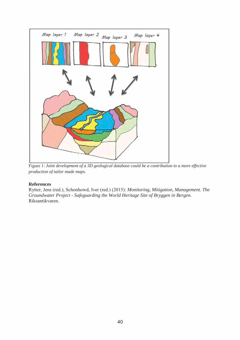
Joint development of a 3D geological database could be a contribution to a more effective production of tailor made maps.
References Monitoring, Mitigation, Management. The
Groundwater Project - Safeguarding the World Heritage Site of Bryggen in Bergen.

Notes:

Notes:

Notes:

Notes:

Notes:

Notes:

Notes:

Notes:

Notes:

Notes: