ni 43-101 technical report el porvenir … · el porvenir project antioquia department, colombia of...
TRANSCRIPT

NI 43-101 TECHNICAL REPORT
FOR THE
El PORVENIR PROJECT
ANTIOQUIA DEPARTMENT, COLOMBIA
OF
ANGEL GOLD S.A.S.
FOR
ANGEL GOLD CORP.
Effective Date : January 08, 2015 Signing Date : January 12, 2105
ByJames G . Burns B.Sc., P.Eng.
405 Geraldine Street, Shediac, New Brunswick. E4P 1T4

- i -
PageTABLE OF CONTENTSTable of Contents .......................................................................................................................... -i-Table of Illustrations ..................................................................................................................... -iii-Summary ....................................................................................................................................... -iv-
INTRODUCTION AND TERMS OF REFERENCE Background, Authorization and Purpose.................................................................................. 1 Scope and Limitations .............................................................................................................. 1 Sources of Information ............................................................................................................. 2 Personal Inspection................................................................................................................... 2
Plan of Presentation ................................................................................................................. 2 Abbreviations............................................................................................................................ 3RELIANCE ON OTHER EXPERTS........................................................................................ 4PROPERTY DESCRIPTION & LOCATION Property Location...................................................................................................................... 5 Mineral Tenure.......................................................................................................................... 5 Colombian Mining Law Overview........................................................................................... 8 Other Encumbrances................................................................................................................. 9 Environmental Liabilities.......................................................................................................... 9 Forest Reserve........................................................................................................................... 9 Permits...................................................................................................................................... 10 Other Significant Factors or Risks............................................................................................ 10 Surface Rights........................................................................................................................... 10ACCESS, CLIMATE, LOCAL RESOURCES, INFRASTRUCTURE & PHYSIOGRAPHY Access....................................................................................................................................... 12 Climate...................................................................................................................................... 12 Local Resources........................................................................................................................ 12 Infrastructure............................................................................................................................. 12 Physiography............................................................................................................................. 12EXPLORATION HISTORY...................................................................................................... 14GEOLOGICAL SETTING AND MINERALIZATION Regional ................................................................................................................................... 19 Local and Project...................................................................................................................... 19 Mineralization........................................................................................................................... 21DEPOSIT TYPES ....................................................................................................................... 26EXPLORATION ......................................................................................................................... 28DRILLING ................................................................................................................................... 31SAMPLE PREPARATION, ANALYSIS AND SECURITY Mineros Samples Soil Samples......................................................................................................................... 36 Stream Sediment Samples.................................................................................................... 36

- i i-
TABLE OF CONTENTS (cont’d)
Rock Samples....................................................................................................................... 37 Drill Core Samples............................................................................................................... 39 Angel Gold Samples Drill Core Pulps and Rejects Check Samples...................................................................... 40 Rock Samples....................................................................................................................... 41DATA VERIFICATION ............................................................................................................ 42MINERAL PROCESSING AND METALLURGICAL TESTING ....................................... 43MINERAL RESOURCE ESTIMATES..................................................................................... 44ADJACENT PROPERTIES....................................................................................................... 45OTHER RELEVANT DATA AND INFORMATION ............................................................. 47INTERPRETATION AND CONCLUSIONS .......................................................................... 48RECOMMENDATIONS ............................................................................................................ 49REFERENCES ............................................................................................................................ 53CERTIFICATE ........................................................................................................................... 54

- iii -
TABLE OF ILLUSTRATIONS
APPENDICES Page
APPENDIX 1 Letter of Authorization .................................................................................. 55
APPENDIX II Notes Re Visit to the El Porvenir Project....................................................... 56APPENDIX III Legal Opinion Regarding the Mining Concession Contracts......................... 59APPENDIX 1V Mining Concession Contract Coordinates...................................................... 60
LIST OF TABLES
TABLE 1 Mining Concession Contract Data.................................................................... 5TABLE 2 Mineros Drill Hole Intercepts............................................................................ 18TABLE 3 Check Assays- Abejero Drill Holes................................................................... 29TABLE 4 Check Assays - Guayabales Drill Holes............................................................. 30TABLE 5 Bominas - Mineros Core Holes Data and Significant Intercepts....................... 32TABLE 6 Abejero - Mineros Core Holes Data and Significant Intercepts........................ 33TABLE 7 Abejero South - Mineros Core Holes Data and Significant Intercepts.............. 34TABLE 8 Guayabales - Mineros Core Holes Data and Significant Intercepts................... 35TABLE 9 Segovia Project Vein Sets.................................................................................. 45TABLE 10 Proposed Program Budget.................................................................................. 52
LIST OF FIGURES Page
FIGURE 1 Project Location and Access................................................................. 6FIGURE 2 Mining Concessions.............................................................................. 7FIGURE 3 Surface Rights Map............................................................................... 11FIGURE 4 El Porvenir Project - Local Geology..................................................... 15FIGURE 5 Mineros Rock Samples.......................................................................... 16FIGURE 6 Regional Geology.................................................................................. 20FIGURE 7 Schematic Geological Settings - Gold Deposits in the North and
South American Cordillera................................................................... 27FIGURE 8 Bominas Area Drill Hole and Surface Sample Locations..................... 22FIGURE 9 Abejero Area Drill Hole and Surface Sample Locations...................... 23FIGURE 10 Guayabales Area Drill Hole and Surface Sample Locations................ 24

SUMMARY
Angel Gold S.A.S. (Angel Gold), the Colombian wholly owned subsidiary of Angel Gold Corp. (ANG TSXV), has entered into an agreement whereby Angel Gold may acquire a 100% interest in the 59.45 ha El Porvenir project (The Project or Project) subject to a 3% NSR payable to Mineros, a private Colombian mining company. The Project is located 185 km NE from the city of Medellin, in Antioquia Department, Colombia. Three Mining Concession Contracts that form a single contiguous block comprise the Project. There is paved road access to within 45 km of The Project.
The Project is situated within the Segovia gold belt, the most prolific gold belt in Colombia from which gold has been exploited for 150+ years. The preeminent deposits of the belt are within Gran Colombia Gold’s Segovia project (previously known as Frontino) located <2 km northwest from the Project boundary (Figure 2), and from which past production has been ~4.6 million ounces of gold (Parsons, 2013). Production from the Segovia operation in 2013 amounted to 80,226 ounces gold per year (Gran Colombia Gold MD&A dated March 31, 2014).
Two north / south trending faults conveniently divide the Project geology. Precambrian age gneisses are present east of the Bagre fault, Cretaceous age Sedimentary and volcanic rock units lie between the Bagre and Nus faults and granodiorite rocks of the Segovia batholith lie west of the Nus fault. The gold deposits of Gran Colombia’s Segovia project are hosted by the Segovia batholith. Gold mineralization in the area is believed to be related to the emplacement of the Segovia batholith and the Otu fault located ~7 km west of the El Porvenir project.
As yet, no gold deposit has been delineated on The Project although there are four known areas of gold mineralization; Bominas, Abejero Guayabales and Iguana. Small scale miners have been or are active in each area. Gold is associated with quartz-sulphide veins. Three styles of gold mineralization are recognized; high gold – low silver, high gold – high silver and high silver – low gold.
Between acquiring the Project area (and adjacent lands) in 2006 / 2007 and 2013 Mineros undertook exploration programs that included a) stream sediment sample survey, b) soil sampling, c) sampling of the artisan mine workings, d) sampling any located quartz veins, and e) core drilling. Most work was concentrated in the Bominas, Abejero and Guayabales, and there is a 4 km wide swath in the Project center in which very little work was conducted. Several drill core intercepts were over significant lengths and of high grade gold and / or silver.
Regardless of the considerable amount of work completed previously by Mineros on the El Porvenir project, the project is at an early exploration stage. A two phased exploration program comprising a stream sediment geochemical survey, trenching, environmental baseline studies and core drilling is recommended for this “Property of Merit”. The estimated costs for this program are US$ 92,000.00 for Phase I and US $340,000.00 for Phase II.
iv

NI 43-101 TECHNICAL REPORT
FOR THE
El PORVENIR PROJECT
ANTIOQUIA DEPARTMENT, COLOMBIA
OF
ANGEL GOLD S.A.S.
FOR
ANGEL GOLD CORP.
INTRODUCTION AND TERMS OF REFERENCE
Background, Authorization and Purpose
Angel Gold S.A.S. (Angel Gold), the Colombian wholly owned subsidiary of Angel Gold Corp. (ANG TSXV), has entered into an option agreement titled “Promise of Assignment of Mining Concession Contracts 6717, HHJP-11 (6832) and HHJP-12 (6835)” dated November 14, 2014 with a Colombian company Mineros S.A. (Mineros) by which Angel Gold may acquire from Mineros a 100% interest in the El Porvenir project located in the Antioquia Department, Colombia. By a letter dated November 25, 2014, Ms. Blanca Stella Frias, President, CEO and a director of Angel Gold Corp., requested the preparation of a technical report to NI 43-101 standards for the El Porvenir project (TheProject or Project). The report is to be used to satisfy TSX Venture Exchange continuous disclosure requirements, and may also be used to support a Company initiated financing or to satisfy other TSX Venture Exchange regulatory requirements, provided the data therein is both current and relevant. A copy of the Letter of Authorization is presented in Appendix I.
Scope and Limitations
This report evaluates the mineral potential of the El Porvenir project. Research of historic exploration activities was limited to the project and immediate surrounding area. Data examined to determine the geological setting for the district were sourced from a broader area.
The unit prices for various contractors, laboratory charges, professional fees, etc. have been researched, and are the going rates for Colombian based or expatriate companies

and individuals at the present time. Metric units are used throughout the report.Currency is expressed in Colombian Pesos (COP$) and / or U.S. dollars (US$).
Sources of Information
Sources of information are detailed below, and include those in the public domain as well as personally acquired data.
Data supplied by Angel Gold; Various geological reports produced by the Colombian government agency INGEOMINAS;Discussions with persons knowledgeable of the property and/or area including Sr. Andres Botero, the geologist who was in charge of Mineros’ last work program, and Sr. Ronald Aguinaga and Sr. Anderson Aguinaga who had worked for Mineros and were familiar with the Project area;Various internet websites; Research of technical papers produced in various journals; andDiscussions with Ms. Stella Frias concerning the legal aspects of the property.
Personal Inspection
Between December 2 and December 7, 2014, the Author Traveled to and from Colombia; Met with Angel Gold personnel at the Angel Gold office in Medellin and discussed the data produced by Mineros; Inspected selected drill core produced by Mineros from The Project at the Mineros core storage facility in Remedios; and Visited the Project site.
Notes regarding the Author’s inspection of the core and project visit are provided in Appendix II.
It is the Author’s opinion that the Mineros core logging, data collection, core sampling and assaying have been completed to industry standards in a competent workman like manner. Some errors have been detected with respect to assay data entry into the master assay file, but these are easily corrected.
Plan of Presentation
Angel Gold’s El Porvenir project is presented, described and evaluated herein in accordance with guidelines specified in National Instrument 43-101. Maps that accurately exhibit project location, exploration history, geology and exploration potential are provided. Recommendations are proposed for a staged, multi disciplined exploration work program, including initial environmental baseline studies, that are necessary and warranted to evaluate the project’s economic potential.
2

This report is based upon information available to the Author as of January 8, 2015. A draft copy of this Technical Report has been reviewed by Angel Gold personnel for factual errors, but the Conclusions and Recommendations presented herein are those of the Author.
Abbreviations
COP Colombian Peso US$ United States Dollar Au gold Ag silver Cu Copper Zn Zinc Pb Lead BQ refers to a core hole with core diameter of 36.4mm BTW refers to a core hole with core diameter of 42.0mm NQ refers to a core hole with core diameter of 47.6mm HQ refers to a core hole with core diameter of 63.5mm ~ approximately < less than > more than μ micron (one millionth of a meter) mm millimeter cm centimeter m metre(s) km kilometer km2 square kilometer(s) g/t = ppm grams per tonne = parts per million tonne metric ton (1000 kg or about 2,204.6 pounds) kg kilogram ha hectare qtz quartz py pyrite po pyrrhotite MCC Mining Concession Contract QA / QC Quality Assurance / Quality Control AA atomic absorption (a technique used in assay/analysis) ICP induced couple plasma (a technique used in assay/analysis) Batholith a large intrusive body Stock a small intrusive body
3

RELIANCE ON OTHER EXPERTS
The Author has endeavored to obtain all current and historic technical information that are relevant to The Project, and has assumed that those obtained are accurate and complete. These documents have been carefully reviewed, but neither the completeness nor accuracy of the data could be verified (other than as carried out during the drill core inspection and the Project site visit). Data that were acquired verbally are clearly indicated within the report.
For the legal status of each MCC, the Author has relied upon the legal opinions listed below which were provided by Hernando Escobar & Asociados. Copies of the opinions are presented as Appendix III.
Title Opinion Concession Contract 6717 by Hernando A. Escobar Isaza, undated. Title Opinion Concession Contract 6832 by Hernando A. Escobar Isaza, undated. Title Opinion Concession Contract 6835 by Hernando A. Escobar Isaza, undated.
Copies of the following legal documents were reviewed in order to detail the salient points of the option agreement presented in the section titled “PROPERTYDESCRIPTION AND LOCATION”.
“Promise of assignment of Mining Concession Contracts 6717, HHJP-11 (6832) and HHJP-12 (6835)” between Mineros S.A. and Angel Gold S.A.S. and dated November 14, 2014 (English translation of the Spanish document), 24p. “Certificado de Registro Minero” issued by the Colombian government “Agencia Nacional de Mineria” for concession number 6717. “Certificado de Registro Minero” issued by the Colombian government “Agencia Nacional de Mineria” for concession number 6832. “Certificado de Registro Minero” issued by the Colombian government “Agencia Nacional de Mineria” for concession number 6835.
4

PROPERTY DESCRIPTION AND LOCATION
Property Location
The El Porvenir project is located within the Remedios municipality, Antioquia Department, northwest Colombia, approximately 400 km NNW of the capital Bogota, and 135 km northeast of Medellin (the Antioquia Department capital) (Figure 1). The west boundary of mining concession contract (MCC) 6717 is situated approximately 4.4 km ENE from Remedios town center (Figure 2). Approximate geographic coordinates for the Project center are 74o 37’ west longitude and 7o 04’ north latitude.
Mineral Tenure
Three contiguous MCCs with a total surface area of 5,945.6125 ha (59.46 km2) comprise The Project. Significant information with respect to these three MCCs is presented in Table 1. Angel Gold requested Hernando Escobar & Asociados (HEA), a legal firm based in Medellin, Colombia, to research the title to the three MCCs that comprise the El Porvenir project and to provide a legal opinion thereon. Based upon a review of the Concession Contract files that exist in the Secretary of Mines of Antioquia, HEA concluded that each MCC “mining title is in force, and has complied with the obligations under the respective Concession Contract and the Mining Code” (Appendix III).
Coordinate data for the three MCCs are listed in Appendix IV. As shown in Figure 2,the El Porvenir project encloses two smaller areas for which application permits have been solicited by Continental Gold Limited. The relevant government authority has yet to make a decision regarding theses applications. A 1 – 2m buffer zone surrounds both application permits area, and a 1m wide strip extends from each application permit area to east boundary of the respective concession contract. Angel Gold has applied for the buffer zones and the strips.
Table 1 : Mining Concession Contract DataMCCNo.
Area (ha) Date of Issue
Term DateValid To
Expl. Phase Expiry
Commodity
6717 1,984.6016 August 30, 2006
30 Years May 30, 2037*
May 30, 2016 ^
Au, Ag plus concentrates
6832 1,981.7251 June 4, 2007
30 Years March 4, 2037* #
March 4, 2015 +
Au, Ag and associatedmetals
6835 1,979.2858 June 4, 2007
30 years April 4, 2039*
April 4, 2016 ^^
Au, Ag and associatedmetals
Total 5,945.6125* The contract term was extended by application.# Mineros has applied for an extension for the exploration period for MCC 6832. ^ A further extension to the Exploration Phase must be filed before February 1, 2016. + A petition for an extension of the Exploration Phase was filed on December 1, 2014. ^^ A further extension to the Exploration Phase must be filed before January 4, 2016.
5

6

7

Angel Gold may acquire a 100% interest to the El Porvenir project, subject to a 3% NSR payable to Mineros, by making staged payments to Mineros over a 5 year, 90 day term (90 days being the due diligence period) as follows.
1. US$ 50,000 upon signing the agreement (completed); 2. US$ 50,000 90 days after the signing of the agreement (February 11, 2015); 3. US$ 100,000 at the second anniversary of payment #2 (February 11, 2017); 4. US$ 400,000 at the third anniversary of payment #2 (February 11, 2018); 5. US$ 400,000 at the fourth anniversary of payment #2 (February 11, 2019); and 6. US$ 1,000,000 at the fifth anniversary of payment #2 (February 11, 2020).
In addition, Angel Gold must incur minimum exploration expenses of
US$ 200,000 in the first year plus due diligence period; US$ 500,000 in the second year following the due diligence period; andUS$ 1,500,000 in each of the third, fourth and fifth years following the due diligence period.
Angel Gold may at any time and at its option
Terminate the contract. Acquire a 100% interest to the project by paying Mineros any unpaid option payments.
Colombian Mining Law Overview [Summarized from Ricaurte, 2013, and Ms. S. Frias (pers. comm.)]
As stated in Article 332 of the Colombian Constitution, the subsoil and all non-renewable resources are State owned. Exploration for and exploitation of mineral resources are governed by the Colombian Mining Code (Law 685) enacted in 2001. The Ministry of Mines and Energy (MME) is responsible for the regulation and monitoring of mineral resources, while the National Mining Agency (NMA) within the MME administers the Mining Code. In certain Departments, such as Antioquia, where exploration and mining are more intense, departmental delegations manage the Mining Code. The NMA keeps the national mining registry. Salient points of the Mining Code are:
Although the state owns the subsoil and all non renewable resources, rights acquired on mineral deposits granted on the basis of prior laws are respected. (The El Porvenir project is subject only to Law 685/2001.) The Colombian state may not exploit mineral resources, but instead issues MCCs to third parties. MCCs are granted on a “first come – first served” basis and once registered with the NMA are in effect. MCCs are commodity specific. (For the El Porvenir project the commodities are Au and Ag.) MCCs are defined by UTM coordinates, Bogota datum.
8

An MCC title holder has, at its own risk and account, the exclusive and temporary right to pursue exploration and exploitation activities in the MCC area, and to acquire ownership of the minerals extracted. An MCC entitles the holder to establish easements for access, development, etc. as necessary for its activities. Compensation payable to the land (surface) holder is required. An MCC is granted for a 30 year term, but by application may be extended for an additional 30 years provided the title holder meets all conditions required by law. An MCC comprises three phases; exploration, construction and exploitation:
o The exploration term, the time allotted to discover and define a mineral deposit, is initially 3 years, but may be extended by an additional 8 years (11 years total) upon application.
o The construction period in which to build a mine and install infrastructure is 3 years, but may be extended for one additional year.
o The remainder of the MCC 30 year term is the exploitation period. A further 30 year period may be requested.
An annual surface fee or canon is payable to the Colombian government during the exploration and construction phases. The fee is calculated by multiplying the minimum daily wage (in 2014 the amount is 20,633 COP) times the number of hectares in each MCC. For MCCs of 2,000 ha to 5,000 ha the amount doubles, and for 5,000 ha to 10,000 ha the amount triples. In 2014 the payments for the three MCCs amounted to 119,408,202 COP (~$ 41,130.00 US). During the exploitation period, a royalty is payable to the Colombian government. For Au and Ag the royalty is 4% of gross production based upon 80% of the afternoon fix on the London Bullion Market for an effective 3.2% rate.
Other Encumbrances
There are no agreements with third parties in respect of the El Porvenir project, nor are there any royalties, back in rights or payments due to any other individual, partnership or business (Ms. Stella Frias, pers. comm.).
Environmental Liabilities
There are no known environmental liabilities associated with the El Porvenir project.Numerous small scale mining operations have been conducted previously by individuals, and there a few still active. All of these operations have not been large enough to cause any environmental degradation.
Forest Reserve
The Magdalena Forest Reserve is a 1,500,000 ha reserve established in 1959 that extends in a north / south direction across the country and crosses 10 Departments. A 150 m wide strip of this reserve overlaps the east Project boundary (Figure 2). There is a process, should Angel Gold choose to do so, to have the strip removed from the Forest Reserve (Ms. Stella Frias, pers. comm.).
9

Permits
A “Natural Resource Use Permit” is required during the exploration phase. This permit, one of which is required for each MCC, allows the title holder to draw and to discharge water for drilling and / or other activities, and also to cut and prune trees as may be necessary to build access tracks, drill pads, etc. Mineros notified the relevant authority that it wished to terminate the requisite permits, but at Angel Gold’s request is in the process of withdrawing the termination notice (Ms. Stella Frias, pers. comm.).
Other Significant Factors or Risks
In certain parts of Colombia personal safety can be a problem. To preempt any problems, a company may apply to the Hidrocarburos office of the Colombian Army to supply security on an as needed basis (Ms Stella Frias, pers. comm.).
Mineros, reportedly, had good, informal relations with those individuals conducting small scale mining operations on The Project. As a means to formalize relations between the small scale miners and companies, the Colombian government has devised an “Operations Contract” to be entered into by the small scale miners and companies whereby the small scale miners may continue activities while the company conducts exploration, but that the small scale miners agree to be responsible for any environmental degradation caused by their activities. As yet, no such Operations Contracts have been signed with any of the small scale miners working on The Project (Ms. Stella Frias, pers. comm.).
Surface Rights
Surface rights across The Project are held by 84 third parties (Figure 3). The majority of the third parties are believed to be individuals or groups of two or more individuals, but one, that partially covers the NW corner of MCC 6717, is a company that harvests sugar cane. By Colombian law, the surface rights holder cannot deny access to the land for exploration, but it is in the company’s best interest to negotiate with the land owners to mitigate any damages caused as a result of exploration activities.
Neither Mineros nor Angel Gold own the surface rights to any of the 84 properties.
10

11

ACCESS, CLIMATE, LOCAL RESOURCES, INFRASTRUCTURE, AND PHYSIOGRAPHY
Access
There is good road access from Medellin to Remedios, the closest town to The Project.From Medellin, follow Autopista de la Costa, a 4 lane paved highway, approximately 35 km eastward to the town of Barbosa. At Barbosa take highway 6205 and then highway 62 (both 6205 & 62 are secondary, narrow, twisty, two lane, paved roads) northeastward to Remedios (Figure 1). Total road distance from Medellin is 185 km. From Remedios, a poorly maintained dirt road heads in a general ENE direction and provides access to the centre of MCC 6717. Straight line distance from Remedios to the MCC boundary is approximately 4.4 km (5~6 km by road). At the present time this road is drivable only to within 2 km of the property boundary. Several trails that connect with roads to the south of the project provide access by foot, horseback or motor bike throughout the eastern two mining concession contract areas (Figure 2).
Climate
The project area is situated between 250 and 620m elevation within the central cordillera of the Andes, and has a tropical mountain climate with an annual average daily high of 25oC. Rainfall in the region is approximately 2.7 m, with the majority of the precipitation falling during the months of May to December. Normally, exploration and mining, both open pit and underground, can be conducted year round, but extreme rainfall may temporarily disrupt activities.
Local Resources
The towns of Remedios, population ~30,000 (located 4.4 km west of The Project) and Segovia, population ~40,000 (~5.0 km WNW of The Project) have a long history of mining. Both towns supply labour and some services to exploration and mining companies active in the area. There is an army base at Segovia which can and does supply security as necessary.
Infrastructure
Infrastructure across The Project consists solely of farm buildings, power lines running to some of the farms and the roads, trails and tracks to the various farms. The closest high voltage power line is at Remedios. There is a small airport with 946 m by 15 m asphalt air strip at Otu, a village on the outskirts of Remedios.
Physiography
The western two thirds of MCC 6717 is typified by rolling hills, whereas the remainder of The Project is more rugged and dominated by north/south trending hills and gullies (Figure 2). Elevation ranges from a high of 621m in the approximate centre of MCC
12

6717 to a low of 250 m where the north flowing Rio Bagre crosses the north boundary of MCC 6832.
MCCs 6832, 6835 and the northern portion of 6717 are drained by the north flowing Rio Bagre, whereas the southern part of 6717 is drained by the westward flowing Rio Ite.Both Rio Bagre and Rio Ite systems could supply sufficient water for exploration activities, but reservoirs may be required to ensure an adequate water supply for year round mining / milling operations.
Approximately 2/3 of the Project area is forest covered. The remainder has been cleared for farming, mainly cattle ranching, but at least one farm covering a portion of concession contract 6717 produces sugar cane.
There is sufficient space within the project area for a mining operation, including either an open pit or underground mine, an on site mill, ancillary buildings, tailings ponds, heap leach pads, waste rock dumps, etc.
13

EXPLORATION HISTORY
The El Porvenir project lies within the prolific Segovia gold belt of northern Colombia from which gold has been exploited for 150+ years (Alvarez, M., et al., 2007). The preeminent deposits of the belt are within Gran Colombia Gold’s Segovia project (previously known as Frontino) located <2 km northwest from the Project boundary (Figure 2), and from which past production has been 4.6 million ounces of gold (Parsons, 2013). Production in 2013 amounted to 80,226 ounces of gold (Gran Colombia Gold MD&A dated March 31, 2014).
There has been no formal gold (nor other metal) production from the El Porvenir project area. The artisan workings are all small scale, hand dug adits and shafts from which material has been bagged and shipped elsewhere for processing. Records of gold recovered do not exist. No gold and / or silver deposit has been delineated within the El Porvenir project area, thus no mineral resources nor reserves have been estimated.
The three MCCs that comprise the El Porvenir project were acquired by Mineros, by application to the relevant government authority, in 2006 and 2007, and formed part of Mineros’ contiguous nine MCC Remedios project. Between 2006/2007 and 2013 Mineros undertook an aggressive exploration program on their Remedios project. Work completed on the El Porvenir project area included a) stream sediment sample survey, b)soil sampling, c) sampling of the artisan mine workings, d) sampling any located quartz veins, and e) core drilling (Figure 4 & 5).
The Mineros stream sediment sampling program on their Remedios project was conducted between March 12 and June 15, 2013. As only 60 samples were collected in total it is assumed that the survey was secondary to other work being conducted. No report is available that describes the Mineros field procedures regarding the collection of samples, although data recorded on the spreadsheet that lists the analytical results indicate that notes were taken regarding sample location (presumably with a hand held GPS), stream flow, water quality, stream bed material, stream gradient, channel width, type and shape of clasts, etc. As only 6 samples were taken from the El Porvenir project area, all in the eastern half of MCC 6717 (Figure 4), the Mineros stream sediment sampling program in no way effectively assessed the El Porvenir project area. The highest value for the six samples, 0.078 ppm, is considered to be weakly anomalous.
For the Mineros soil sampling programs no report is available that describes the field procedures, although some information are entered on the spreadsheet with the analytical results. Sample location were recorded, presumably with a hand held GPS, in UTM coordinates.
Mineros conducted two soil sampling programs each with different objectives (Figure 4).For the first program, samples were collected at 500 m x 500 m spacings over the western 1.25 km of the nine western MCC Remedios project, including MCC 6717, as a means to identify target areas for immediate follow up exploration. Of the thirty-five (35) samples collected from El Porvenir, 2 were recorded from the A horizon, 30 from the B horizon, 1
14

15

16

from the C horizon and 2 without record. Sample weights and depths were not recorded.None of the results were anomalous for Au. As no maps are available for the base metal elements and other trace elements it is assumed that these were not reviewed.
In the second program, samples were collected at 50 m spacings along short, NE/SW 200 m long lines spaced ~200 m apart. The apparent intent was to evaluate an interpreted NW/SE geological structure extending from the Las Verticales deposit of Gran Colombia’s Segovia project (Figure 4). Forty-one (41) samples were collected on MCC 6717, all from the B horizon. Twenty-one (21) samples were collected at an average 1.3 m depth, and weighed ~2 kg. None of the results were anomalous for Au. As no maps are available for the base metal elements and other trace elements it is assumed that these were not reviewed.
Most of the 406 rock samples were collected from, and all of the core drilling was completed in four areas with artisan workings within The Project, namely Bominas, Abejero, Guayabales and Iguana (Figures 4 & 5). Note on Figure 4 that there is a 4 km wide north south swath in the central project area in which very little exploration was undertaken.
Mineros geologists collected rock samples from artisan workings and quartz vein located in outcrops and further exposed in short, hand dug trenches. No report is available that describes the Mineros field procedures regarding the collection of rock samples from trenches and outcrops, although data recorded on the spreadsheet that lists the analytical results indicate that notes were taken regarding sample location (presumably with a hand held GPS), vein strike, dip and thickness, vein mineralogy, wall rock alteration, etc. Of the 165 rock samples selected in the Bominas (also known as El Congo) area, 28 assayed >0.5 g/t Au. The best (>5.0 g/t Au) gold assay were for samples obtained from the Pedro Castrillon underground workings (33.1, 19.85, 16.2, 9.41, 9.06 and 8.97 g/t Au) and at the nearby (+/- 250 m) El Encantado mine (405 g/t Au, 190 g/t Ag), El Tesoro mine (44.9 g/t Au) and Bagresito mine (41.3, 35.0, 10.1 & 9.7 g/t Au). The veins are generally 20 – 35 cm thick, and the better assays are for samples containing sulphide minerals, notably galena. Except for the El Encantado sample all silver value were <30 g/t Ag.
Some 70 rock samples were collected for assay in the Abejero area of which 20 assayed >0.50 g/t Au. Again the better assays (35.3, 18.08, 14.4, 10.95, 6.51, 5.85, and 5.35 g/t Au) were for samples taken from mine workings. There were, however, a few interesting assays (19.3, and 4.22 g/t Au) for sample collected from outcrop. Veins range to 0.80 m thick and are variably mineralized with sulphides. A single high silver value of 49.2 g/t was recorded for the outcrop sample that assayed 4.22 g/t Au. All other silver assays were well below 30 g/t Ag.
The Guayabales area appears to be more silver than gold rich. Of the 70 rock samples collected 18 assayed >0.5 g/t Au, but the highest value was only 4.49 g/t Au. The higher silver assays (>30 g/t Ag) were 606, 301, 268, 251, 235, 166, 150, 134, 80.0, 62.5, 40.6, 38.6 and 36.7 g/t Ag. Minor fine grained pyrite +/- galena and / or chalcopyrite are normally present. Native silver was noted in one sample.
17

All 44 rock samples collected by Mineros in the Iguana assayed low in both gold and silver. The best values were for two samples from a small mine called Los Naranjos – 0.17 g/t Au & 7.61 g/t Ag and 1.23 g/t Au & 8.02 g/t Ag. It would appear that Mineros did not focus on this area as at least 11 of the 42 samples were of float.
Within the El Porvenir project area Mineros core drilled 7,216.6 m in 89 holes. All holes were shallow (average depth a mere 81.1 m), and were drilled in a semi regular manner at more or less 100 m intervals along the interpreted / suspected trend of the major quartz veins. Of the 89 holes drilled only 16 cut intervals with interesting Au +/- Ag values (>0.5 ppm Au & >5.0 ppm Ag). Most intervals were short (<2.0 m), but some were of exceptionally high value. There appear to be three assay groupings; a) high gold with low silver, b) high silver with low gold and c) high gold and high silver. The better assay intervals are as follows in Table 2.
Table 2 : Mineros Drill Hole InterceptsArea Hole # From (m) To (m) Length
(m)*Au (ppm) Ag (ppm)
Abejero RBA-002 48.37 53.95 4.58 70.35 40.6 Abejero RBA-003 62.70 63.25 0.55 14.10 8.9 Abejero RBA-004 50.42 50.95 0.53 0.08 8.3 Abejero RBA-014 53.25 53.90 0.65 4.56 2.6 Abejero RBA-016 55.95 57.55 1.60 19.40 9.3 Guayabales RBG-036 82.74 82.98 0.24 0.13 14.1 Guayabales RBG-039 64.45 65.10 0.65 0.41 73.4 Guayabales RBG-041 6.95 7.20 0.25 0.97 0.7 Guatabales RBG-045 60.25 60.55 0.30 0.03 88.0 Guayabales RBG-046 17.10 17.40 0.30 0.56 13.1 Guayabales RBG-046 45.90 46.30 0.40 1.19 35.9 Guayabales RBG-047 20.75 21.90 1.15 0.11 7.7 Guayabales RBG-048 46.70 47.92 1.22 0.05 6.9 Guayabales RBG-049 27.15 36.15 9.00 0.76 89.9 Bominas RCG-009 22.22 24.10 1.88 0.01 420.0 Bominas RCG-009 39.95 41.10 1.45 0.01 441.0 Bominas RCG-009 114.49 116.84 2.35 9.74 0.8 Bominas RCG-016 31.00 33.25 2.25 23.10 13.5 Bominas RCG-017 3.40 6.60 3.20 0.76 0.2 Bominas RCG-017 83.40 84.40 1.00 39.40 15.7 Bominas RCG-023 97.90 99.60 1.70 0.05 1210.0* The relationship between Intercept length and true width is unknown.
18

GEOLOGICAL SETTING AND MINERALIZATION
Regional
The regional geology, as shown in Figure 6, is divided into east and west sectors by the Otu fault. This deep seated, steeply dipping fault generally strikes N/S to N10oW (with inflections at N30oW), and has a 66 km sinistral displacement (Gonzalez, 1992). To the east the dominant lithologies are Precambrian quartz gneiss, marble and amphibolite and the Jurassic age Segovia batholith. Volcanic and sedimentary rock units are present between the dextral Nus fault and the sinistral Bagre fault which have displacement of some 50 km. West of the Otu fault, the basement gneisses / migmatite rock units are of uncertain age, and have been intruded by quartz –diorite stocks of the La Culebra and Santa Isabel groups (Alvarez et al., 2007).
There are significant differences between the two sectors as to the metamorphic grade of the basement (older) rocks and their deformation history. East of the Otu fault the metamorphic grade is upper amphibolite, and two phases of deformation are observed. West of the fault the metamorphic grade is greenschist to mid amphibolite, and there are three deformation phases (Alvarez et al., 2007).
Local and Project
The El Porvenir project area is located in the east sector a minimum of 7 km east of the Otu fault (Figure 6). The local and Project geology may be divided into three N/S segments or blocks by the Nus and Bagre faults (Figure 4). East of the Bagre fault are the Precambrian gneisses. Their composition varies from quartzose to quartz- feldspar to quartz-biotite, and are well banded Londono et al., 2007).
The Jurassic age (154 +/-1.6Ma) Segovia batholith lies west of the Nus fault. It varies in composition from diorite to quartz-diorite to granite in composition, and is medium to coarse grained. Primary minerals are quartz, plagioclase feldspar, hornblende and mica. Accessory minerals include allanite, magmetite-illmenite, apatite, pyrite and zircon (Andrews, 2013). Porphyry dykes of 2-3 m thick and of basaltic composition cut the Segovia batholith. These dykes are fine grained and contain coarse (up to 7mm) phenocrysts of plagioclase set in a dark coloured matrix (Parsons, 2013)
Underlying the central segment between the Nus and Bagre faults are lower Cretaceous age intercalated sedimentary and volcanic rock units. The sediments are mainly carbonaceous shale, fine grained sandstone and minor conglomerate, and are well stratified. These rocks generally strike N/S (but vary between N10oE to N46oW). Their dips vary due to folds. The volcanic rocks are of andesite composition, are fine grained, contain plagioclase phenocrysts, and occur within the shale units. Rock units of the older Segovia batholith are mapped as “islands” within this segment (Londono et al., 2007). [Elsewhere, the conglomerate contains granite clasts of the Segovia intrusion (Gonzalez, 1992) which indicates that the sedimentary and volcanic rock units discordantly overlie the Segovia batholith.]
19

20

The Nus and Bagre faults are considerably older than the Otu fault, but younger than the Segovia batholith. Both dip steeply, and have lateral displacements of approximately 50 km, Nus dextrally and Bagre sinistrally (Gonzalez, 1992). Vertical movement is unknown.
On satellite imagery, the N/S to NNW/SSE striking Bagre fault is the dominant structural feature. Other lineament directions are 115o, 145 o and 075 o.
Except in the valleys, soil cover is generally thin. The weathered rock, however, can be quite thick, and was noted to exceed 15 m vertical in the drill core examined.
Mineralization
Gold (and silver) mineralization in the area occurs in the Segovia batholith and in the neighbouring sedimentary, volcanic and gneissic rocks, and is believed related to the Segovia batholith and the Otu fault, with movement along the latter having caused fracturing along which the quartz – sulphide veins were emplaced.
There are four areas of know Au and / or Ag mineralization within the Projectboundaries; Bominas (also known as El Congo), Abejero, Guayabales and Iguana (Figure 5). At all locales, the mineralization is associated with quartz – sulphide veins. There appear to be three styles of mineralization; high Au – low Ag, high Ag – low Au, and high Au – high Ag. The main mineralization style at Bominas, Abejero and Iguana are high Au – low Ag, while at Guayabales it is high Au – high Ag. Intervals of high Ag – low Au are sporadic and appear to be discontinuous.
The Bominas and Abejero areas are underlain by Precambrian age gneiss. In both areas multi quartz veins and multiple vein directions are indicated (Figures 8 & 9). Veins are <1 m thick (generally <0.5 m), may be milky, banded or vuggy, and have associated sulphide and iron oxide mineralization. Sulphide mineralization is always present in samples with better Au values. Alteration peripheral to the veins is typically thin (<30 cm) as seen in drill core and consist of silicification, albitization, sericitization, bleaching or a combination thereof. Generally, Au values are greater than or even much greater than the Ag values, but exceptions do exist. The interpreted (by Mineros) traces for the veins are NNE for Bominas and NW for Abejero (Figures 8 & 9).
The Guayabales area is shown on Figures 4 and 6 as being underlain Cretaceous age sedimentary rocks. However, the host lithologies, as seen in drill core and as noted by Angel Gold geologist during a field visit, are in fact granodiorite / quartz diorite / diorite units that of the Segovia batholith. As mapped by Londono et al. these intrusive units are part of an island within the sedimentary rocks. There appear to be two main trends to the mineralization (as interpreted by Mineros); ENE in the north and NNE to the south (Figure 10), although as there are multi veins in the area with multiple directions the trend(s) is (are) open to re-interpretation. The quartz veins exposed at surface or in small adits are as a rule, <0.5 m thick, although an intercept in hole RGB-49 was 9.0 m (true width unknown). Sulphide mineralization is always present in samples with better Ag-Au
21

22

23

24

values, and Ag values are much greater than Au. Alteration peripheral to the veins is typically thin (<30 cm) as observed in drill core, and consist of silicification, albitization, sericitization, bleaching or a combination thereof.
Segovia batholith granodiorite hosts the veins in the Iguana area. The veins seen at the two small scale mines visited have approximate E/W strikes, but with dips in opposite directions, while the strike of the sericitized zone noted on the access road was NW/SE to NNW/SSE. The veins seen and sampled were banned and vuggy, with associated sulphide and iron oxide mineralization.
Many of the holes drilled by Mineros at Bominas, Abejero and Guayabales failed to cut significant mineralization. There are two possible explanations. First, the Mineros interpreted vein traces are for dipping veins, apparently assumed to be dipping overall at around 45o. Should the dip of the vein have been steeper than the inferred 45o then it is likely that at least some of the holes may have failed to reach the targeted vein. Second, although the veins at Gran Colombia’s Segovia operation are continuous over long distances (1-2 km), at El Porvenir, they may be discontinuous. The existence of multiple veins at multiple orientations is suggestive of a stockwork.
The fact that the Guayabales area is Ag-rich is anomalous. In gold - silver districts, gold-rich deposit are found at higher stratigraphic elevations relative to silver-rich deposits.The Guayabales intrusive rocks are located within the sedimentary / volcanic block between the granitic block hosting the gold-dominant Segovia workings west of the Nus fault, and the gold-rich small miner workings in metamorphic gneisses in the block east of the Bagre fault. These faults were interpreted as being strike-slip, but there is probably a vertical component of movement as well. There is a 50 km horizontal displacement inferred for both the Nus and Bagre faults. As Nus is dextral and the Bagre sinistral, then the Guayabales mineralization in the central block might be inferred to be have been emplaced some 50 km distant, northwards, from the gold-rich mineralization both west and east of this central block. Whether or not this interpretation is correct is dependent on the timing of the emplacement of the mineralized veins relative to the movement on the Bagre and Nus faults. As the central block is also tilted and in-filled with sediments and volcanics overlying gneisses, it is more likely that the central block has undergone down drop rather than uplift relative the other blocks (with more drop on Nus fault relative to Bagre fault). It is possible, then, that this central block may represent a higher and/or more distal level in the overall mineralized system.
25

DEPOSIT TYPES
Sillitoe (2008) classifies the gold deposits of North and South America into five broad categories; 1) epithermal deposits in shallow volcanic environments, 2) porphyry gold or gold only deposits in the subvolcanic environment, 3) sediment hosted (or Carlin-type) deposits in non-metamorphosed, carbonate-rich sedimentary sequences, 4) pluton-related deposits in deeper, but still epizonal intrusive environments and 5) orogenic deposits in metamorphic rocks, commonly assignable to greenschist facies (Figure 7). Deposits of the Segovia belt are classified as “Oxidized Pluton-Related Deposit” within the pluton-related (#4) category. They are believed to be genetically related to the Segovia batholith, but to have formed after the batholith cooled and under stress conditions induced by the Otu fault. The main characteristics of “Oxidized Pluton-Related Gold Deposits” are:
They occur as quartz veins, sheeted quartz veins and stockworks. Associated elements are Cu, Pb, Zn and Mo, and these normally are present as sulphide minerals. The deposits may occur both in the pluton itself and in the intruded wall rocks. Common alteration types that occur proximal to the deposits are alkali feldspar and sericite.
Standard geochemical exploration techniques may be applied in the search for deposits of this type since a) sheeted veins and stockwork deposits may have a surface expression measured in hectare or tens of hectares, and b) they normally have associated base metals (Cu, Pb, Zn & Mo). A stream sediment survey is useful to define broad target areas, while a more tightly controlled soil survey is employed to define trenching or drill targets.
26

27

EXPLORATION
Angel Gold recently acquired The Project and as yet has not conducted any exploration program. As part of its due diligence process, Angel Gold
In mid December, sent a field party to the project to locate and confirm Mineros drill hole sites, and to prospect for and sample reported quartz veins; Collected from Mineros warehouses selected samples of pulp, fine reject and coarse reject material for several Mineros drill holes, and submitted these for check assay.
Fourteen overgrown drill sites were located in the Guayabales area by the Angel Gold field crew. The UTM coordinates for each site correspond with those noted for the Mineros drill holes. The field crew also noted that the Mineros trenches in which quartz veins had been exposed were in-filled and are now overgrown with no trace left in the field. Seven (7) samples of quartz veins or weakly altered out crop were collected by the field crew, and submitted for assay. Gold and silver values for samples from mudstone or diorite outcrops were at or below detection limits. A 0.6 m continuous chip sample across a 20 cm quartz vein mineralized with 1-2% py, minor galena and a trace sphalerite plus 20cm of wall rock from each side of the vein assayed 0.216 ppm Au and 56.8 ppm Ag. A second 0.6 m continuous chip sample across a different quartz vein and also mineralized with 1-2% py, minor galena and a trace sphalerite assayed 0.261 ppm Au and 10.8 ppm Ag.
A total of 92 pulp, fine reject and coarse reject samples were collected from across a range of Au and Ag values, and sent to Actlabs in Medellin for check assay. Comparison list of results are presented as Table 3 for Abejero and Table 4 for Guayabales. In general, the comparison between the original Mineros assays and the Angel Gold check assays is excellent for both gold and silver. There are a few samples with high Au or Ag values for which the check assays values differed from those of the original assays, but even for these samples the values were of the same order of magnitude. The difference is attributed to the “nugget effect” whereby the Au is not evenly distributed even after crushing and pulping.
28

Hol
e N
o.S
ampl
eN
o.A
u (p
pm)
Ag
(ppm
)S
ampl
e N
o.A
u (p
pm)
Ag
(ppm
)S
ampl
e N
o.A
u (p
pm)
Ag
(ppm
)S
ampl
e N
o.A
u (p
pm)
Ag
(ppm
)
RB
AD
DH
_002
DH
0904
70.
20.
3R
0012
00.
182
0.2
RB
AD
DH
_002
DH
0904
827
014
5R
0012
126
713
7R
0011
416
294
.9R
BA
DD
H_0
02D
H09
049
0.77
1R
0012
20.
832
0.9
R00
115
0.55
80.
2
RB
AD
DH
_002
DH
0905
10.
470.
4R
0012
30.
516
0.4
RB
AD
DH
_002
DH
0905
217
.65
23.9
R00
124
16.5
23.7
R00
116
1220
.9R
BA
DD
H_0
02D
H09
053
0.05
0.3
R00
125
0.03
90.
3R
0011
70.
021
0.3
RB
AD
DH
_003
DH
0905
414
.18.
9R
0012
618
.36.
6
RB
AD
DH
_012
DH
0907
30.
121.
57R
0012
70.
141.
7R
0013
80.
141.
6
RB
AD
DH
_014
DH
0907
64.
562.
64R
0012
84.
237
3.3
R00
139
4.36
13.
3R
BA
DD
H_0
14D
H09
077
0.01
0.07
R00
129
0.01
4<0
.1R
0014
00.
008
<0.1
RB
AD
DH
_014
DH
0907
80.
010.
04R
0013
00.
006
<0.1
R00
141
<0.0
05<0
.1
RB
AD
DH
_016
DH
0908
419
.49.
26R
0013
119
.28.
1R
0014
219
.58.
1
RB
AD
DH
_020
DH
0910
10.
010.
01R
0013
20.
007
<0.1
RB
AD
DH
_020
DH
0910
20.
010.
02R
0013
3<0
.005
<0.1
RB
AD
DH
_020
DH
0910
30.
010.
04R
0013
4<0
.005
<0.1
R00
118
0.01
20.
3R
BA
DD
H_0
20D
H09
104
0.01
0.04
R00
135
<0.0
05<0
.1R
0011
9<0
.005
0.3
RB
AD
DH
_020
DH
0910
80.
010.
01R
0013
6<0
.005
<0.1
RB
AD
DH
_020
DH
0910
90.
010.
01R
0013
7<0
.005
<0.1
Tabl
e 3
: Che
ck A
ssay
s - A
beje
ro D
rill H
oles
Orig
inal
Sam
ple
Che
ck A
ssay
s - P
ulps
Che
ck A
ssay
s - F
ine
Rej
ects
Che
ck A
ssay
s - C
oars
e R
ejec
ts
29

Hol
e N
o.S
ampl
eN
o.A
u (p
pm)
Ag
(ppm
)S
ampl
e N
o.A
u (p
pm)
Ag
(ppm
)S
ampl
e N
o.A
u (p
pm)
Ag
(ppm
)S
ampl
e N
o.A
u (p
pm)
Ag
(ppm
)
RB
GD
DH
_036
DH
0950
40.
1314
.05
R00
051
0.10
716
.8R
0008
10.
051
15.7
RB
GD
DH
_039
DH
0950
10.
010.
14R
0005
2<0
.005
0.2
R00
082
<0.0
050.
3R
0009
2 <
0.00
50.
6R
BG
DD
H_0
39D
H09
502
0.41
73.4
R00
053
0.37
488
.4R
0008
30.
401
74.2
R00
093
0.42
100
RB
GD
DH
_039
DH
0950
30.
010.
13R
0005
4<0
.005
0.3
R00
084
<0.0
050.
2R
0009
4<0
.005
0.9
RB
GD
DH
_045
DH
0916
60.
0388
R00
055
0.03
692
.6R
0008
50.
039
87
RB
GD
DH
_046
DH
0919
30.
010.
1R
0005
6<0
.005
0.2
R00
086
<0.0
050.
2R
BG
DD
H_0
46D
H09
194
0.01
0.05
R00
057
<0.0
05<0
.1R
0008
7<0
.005
<0.1
RB
GD
DH
_046
DH
0919
60.
010.
12R
0005
8<0
.005
0.1
R00
088
<0.0
050.
1R
BG
DD
H_0
46D
H09
197
0.01
0.06
R00
059
<0.0
05<0
.1R
0008
9<0
.005
<0.1
RB
GD
DH
_046
DH
0919
80.
5613
.1R
0006
00.
537
13.5
R00
090
0.56
13.5
RB
GD
DH
_046
DH
0919
90.
010.
14R
0006
1<0
.005
0.2
R00
091
<0.0
050.
3
RB
GD
DH
_049
DH
0961
40.
14.
42R
0006
20.
097
4.8
R00
095
0.10
55.
5R
BG
DD
H_0
49D
H09
615
0.67
199
R00
063
0.54
921
3.5
R00
096
0.60
919
9R
BG
DD
H_0
49D
H09
616
0.47
19.5
5R
0006
40.
451
19.5
R00
097
0.50
220
.9R
BG
DD
H_0
49D
H09
617
0.44
22.9
R00
065
0.42
623
.4R
0009
80.
439
22.7
RB
GD
DH
_049
DH
0961
80.
8998
R00
066
0.90
314
2.8
R00
099
0.44
196
.9R
BG
DD
H_0
49D
H09
619
1.2
209
R00
067
1.15
927
7.8
R00
100
1.12
224
2
RB
GD
DH
_049
DH
0962
11.
1510
5R
0006
81.
053
95.1
R00
101
1.08
210
1R
BG
DD
H_0
49D
H09
622
0.56
19R
0006
90.
544
19.5
R00
102
0.41
519
.4R
BG
DD
H_0
49D
H09
623
0.12
4.04
R00
070
0.12
24.
4R
0010
30.
117
6.3
RB
GD
DH
_049
DH
0962
40.
15.
09R
0007
10.
108
5.2
R00
104
0.10
55.
4
RB
GD
DH
_049
DH
0962
60.
010.
46R
0007
20.
011
0.5
R00
105
0.00
80.
6R
BG
DD
H_0
49D
H09
627
0.02
1.36
R00
073
0.02
11.
4R
0010
60.
022
1.8
RB
GD
DH
_049
DH
0962
80.
020.
68R
0007
40.
023
0.7
R00
107
0.02
30.
7R
BG
DD
H_0
49D
H09
629
0.03
1.14
R00
075
0.03
51.
2R
0010
80.
036
1.5
RB
GD
DH
_049
DH
0963
10.
030.
96R
0007
60.
029
1R
0010
90.
026
1.3
RB
GD
DH
_049
DH
0963
20.
010.
49R
0007
70.
019
0.6
R00
110
0.01
40.
6R
BG
DD
H_0
49D
H09
633
0.32
3.53
R00
078
0.33
93.
4R
0011
10.
365
2.3
RB
GD
DH
_049
DH
0963
40.
021
R00
079
0.02
41
R00
112
0.02
20.
7R
BG
DD
H_0
49D
H09
635
0.03
0.37
R00
080
0.01
70.
6R
0011
30.
014
0.2
Tabl
e 4
: Che
ck A
ssay
s - G
uaya
bale
s D
rill H
oles
Orig
inal
Sam
ple
Che
ck A
ssay
s - P
ulps
Che
ck A
ssay
s - F
ine
Rej
ects
Che
ck A
ssay
s - C
oars
e R
ejec
ts
30

DRILLING
Angel Gold recently acquired the El Porvenir project and as yet has not conducted any drill program of any type.
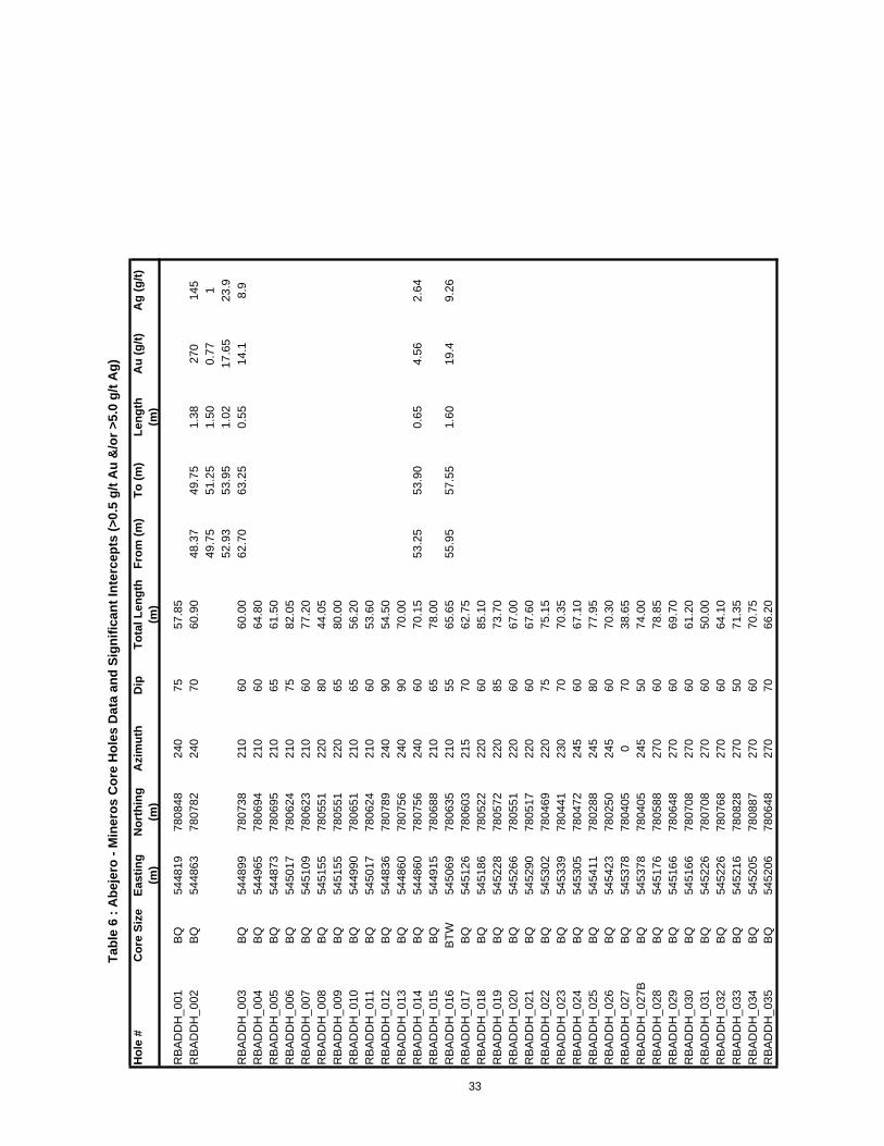
Mineros drilled 89 shallow (average depth 81.1m) core holes within the Projectboundary, 29 in the Bominas area (Figure 8), 36 at Abejero (Figure 9), 7 at Abejero South and 17 at Guayabales (Figures 10). Of these 89 drill holes 62 were BQ (core diameter 36.4mm), 1 was BTW (core diameter 42.0mm), 20 were NQ (core diameter 47.6mm) and 6 were HQ (core diameter 63.5mm) in size. Hole locations, x, y & z coordinates, were determined by differential GPS methodology. Basic data regarding the holes, plus significant intercepts cored, are listed in Tables 5, 6, 7 & 8. The true widths of the intercepts are unknown as the orientation of the mineralization has not been determined.
In each area, the targeted vein(s) was (were) interpreted / assumed by Mineros by plotting a line from artisan working to artisan working or an outcrop with vein exposure. Holes were planned to intersect the strike of these vein at approximate right angles, and at roughly regular intervals. Surprisingly, only 16 of the 89 holes cut significant intercepts despite the numerous exposures of Au +/- Ag mineralized quartz veins in the area. One possible reason for the low number of intercepts might be that the vein trends as interpreted by Mineros are in effect the trends for a mineralized system in which the veins are not only discontinuous but also strike and dip at various angles. As may be seen in Figures 8, 9, & 10 the mapped attitudes of the veins in the areas are highly variable, particularly at Bominas and Guayabales. At Bominas the mapped veins occur across at least a 300 m width and strike NE, NW & ENE with variable dips. Similarly at Guayabales veins strike ENE, WNW, NNE & NE within a general ENE trend. Thus at both Bominas and Guayabales the drill hole directions appear to be semi parallel to one or more vein strikes.
From a brief review of the core during the Author’s property visit, it is believed that the Mineros geologists logged and sampled the core to industry standards. Samples were selected on the basis of the presence of quartz veins, sulphide mineralization and alteration, and did not appear to cross lithological, structural or alteration contacts.
The only drilling, sampling or recovery factor noted that might have affect assay results was core size. Most holes drilled were BQ in size. For gold projects the minimum industry standard core size is NQ, and HQ is preferred, the reason being that the larger the core size the more representative the sample. [NQ is 1.71 times larger than BQ while HQ is 3.04 times larger than BQ and 1.78 times larger than NQ.] Core recovery is also enhanced with larger core, particularly in poor rock conditions such as deeply weathered rock, strongly fractured rock, vuggy veins, clay alteration, etc., as are present at El Porvenir, and which can affect sample quality and thus the accuracy and reliability of assay results.
31

Hol
e #
Cor
e Si
zeEa
stin
g(m
)N
orth
ing
(m)
Azi
mut
hD
ipTo
tal
Leng
th (m
)Fr
om (m
)To
(m)
Leng
th
(m)
Au
(g/t)
Ag
(g/t)
RB
DD
H_0
05B
Q54
5029
7836
5913
060
90.5
0R
BD
DH
_006
BQ
5450
1078
3556
130
6087
.00
RB
DD
H_0
07B
Q54
5011
7835
5613
090
23.2
5R
BD
DH
_008
BQ
5450
0578
3780
115
6086
.30
RB
DD
H_0
09B
Q54
5050
7837
5911
560
75.2
5R
BD
DH
_010
BQ
5450
9978
3791
115
6090
.85
RC
GD
DH
_005
NQ
5450
1878
4808
235
8074
.30
RC
GD
DH
_005
AN
Q54
5016
7848
0723
570
101.
00R
CG
DD
H_0
06N
Q54
5101
7847
1125
560
110.
00R
CG
DD
H_0
07N
Q54
5092
7845
9425
575
115.
00R
CG
DD
H_0
08N
Q54
5125
7844
8925
566
110.
00R
CG
DD
H_0
09N
Q54
5151
7843
6427
570
120.
0022
.22
24.1
01.
880.
0142
039
.95
41.4
01.
450.
0144
111
4.49
116.
842.
359.
740.
8R
CG
DD
H_0
10N
Q54
5149
7842
9227
570
111.
20R
CG
DD
H_0
11N
Q54
5111
7841
9227
560
110.
00R
CG
DD
H_0
12N
Q54
5074
7840
8328
567
120.
00R
CG
DD
H_0
13N
Q54
5040
7839
8928
567
120.
00R
CG
DD
H_0
14N
Q54
5054
7838
9628
065
131.
00R
CG
DD
H_0
15N
Q54
5073
7838
1128
060
113.
00R
CG
DD
H_0
16N
Q54
5046
7837
1528
060
123.
0031
.00
33.2
52.
2523
.113
.5R
CG
DD
H_0
17N
Q54
5031
7836
1728
058
140.
003.
406.
603.
200.
760.
283
.40
84.4
01.
0039
.415
.7R
CG
DD
H_0
18N
Q54
5019
7835
1928
060
90.5
0R
CG
DD
H_0
20N
Q54
4996
7833
1928
060
88.8
5R
CG
DD
H_0
21N
Q54
4990
7832
1728
070
113.
00R
CG
DD
H_0
22N
Q54
4965
7831
0728
065
76.4
5R
CG
DD
H_0
23H
Q54
4959
7830
0228
060
115.
0097
.90
99.6
01.
700.
0512
10R
CG
DD
H_0
24H
Q54
4952
7829
2128
065
100.
00R
CG
DD
H_0
25H
Q54
4947
7828
3228
065
100.
00R
CG
DD
H_0
26H
Q54
4914
7827
3328
065
116.
00R
CG
DD
H_0
27H
Q54
4922
7826
3328
060
100.
00
Tabl
e 5
: Bom
inas
- M
iner
os C
ore
Hol
es D
ata
and
Sign
ifica
nt In
terc
epts
(>0.
5 g/
t Au
&/o
r >5.
0 g/
t Ag)
32
Hol
e #
Cor
e Si
zeEa
stin
g (m
)N
orth
ing
(m)
Azi
mut
hD
ipTo
tal L
engt
h (m
)Fr
om (m
)To
(m)
Leng
th
(m)
Au
(g/t)
Ag
(g/t)
RB
AD
DH
_001
BQ
5448
1978
0848
240
7557
.85
RB
AD
DH
_002
BQ
5448
6378
0782
240
7060
.90
48.3
749
.75
1.38
270
145
49.7
551
.25
1.50
0.77
152
.93
53.9
51.
0217
.65
23.9
RB
AD
DH
_003
BQ
5448
9978
0738
210
6060
.00
62.7
063
.25
0.55
14.1
8.9
RB
AD
DH
_004
BQ
5449
6578
0694
210
6064
.80
RB
AD
DH
_005
BQ
5448
7378
0695
210
6561
.50
RB
AD
DH
_006
BQ
5450
1778
0624
210
7582
.05
RB
AD
DH
_007
BQ
5451
0978
0623
210
6077
.20
RB
AD
DH
_008
BQ
5451
5578
0551
220
8044
.05
RB
AD
DH
_009
BQ
5451
5578
0551
220
6580
.00
RB
AD
DH
_010
BQ
5449
9078
0651
210
6556
.20
RB
AD
DH
_011
BQ
5450
1778
0624
210
6053
.60
RB
AD
DH
_012
BQ
5448
3678
0789
240
9054
.50
RB
AD
DH
_013
BQ
5448
6078
0756
240
9070
.00
RB
AD
DH
_014
BQ
5448
6078
0756
240
6070
.15
53.2
553
.90
0.65
4.56
2.64
RB
AD
DH
_015
BQ
5449
1578
0688
210
6578
.00
RB
AD
DH
_016
BTW
5450
6978
0635
210
5565
.65
55.9
557
.55
1.60
19.4
9.26
RB
AD
DH
_017
BQ
5451
2678
0603
215
7062
.75
RB
AD
DH
_018
BQ
5451
8678
0522
220
6085
.10
RB
AD
DH
_019
BQ
5452
2878
0572
220
8573
.70
RB
AD
DH
_020
BQ
5452
6678
0551
220
6067
.00
RB
AD
DH
_021
BQ
5452
9078
0517
220
6067
.60
RB
AD
DH
_022
BQ
5453
0278
0469
220
7575
.15
RB
AD
DH
_023
BQ
5453
3978
0441
230
7070
.35
RB
AD
DH
_024
BQ
5453
0578
0472
245
6067
.10
RB
AD
DH
_025
BQ
5454
1178
0288
245
8077
.95
RB
AD
DH
_026
BQ
5454
2378
0250
245
6070
.30
RB
AD
DH
_027
BQ
5453
7878
0405
070
38.6
5R
BA
DD
H_0
27B
BQ
5453
7878
0405
245
5074
.00
RB
AD
DH
_028
BQ
5451
7678
0588
270
6078
.85
RB
AD
DH
_029
BQ
5451
6678
0648
270
6069
.70
RB
AD
DH
_030
BQ
5451
6678
0708
270
6061
.20
RB
AD
DH
_031
BQ
5452
2678
0708
270
6050
.00
RB
AD
DH
_032
BQ
5452
2678
0768
270
6064
.10
RB
AD
DH
_033
BQ
5452
1678
0828
270
5071
.35
RB
AD
DH
_034
BQ
5452
0578
0887
270
6070
.75
RB
AD
DH
_035
BQ
5452
0678
0648
270
7066
.20
Tabl
e 6
: Abe
jero
- M
iner
os C
ore
Hol
es D
ata
and
Sign
ifica
nt In
terc
epts
(>0.
5 g/
t Au
&/o
r >5.
0 g/
t Ag)
33

Hol
e #
Cor
e Si
zeEa
stin
g(m
)N
orth
ing
(m)
Azi
mut
hD
ipTo
tal
Leng
th (m
)Fr
om (m
)To
(m)
Leng
th
(m)
Au
(g/t)
Ag
(g/t)
RB
AS
DD
H_0
1B
Q54
5178
7797
6926
055
81.8
5R
BA
SD
DH
_02
BQ
5451
3377
9859
265
6090
.45
RB
AS
DD
H_0
3B
Q54
5106
7799
5027
060
90.4
0R
BA
SD
DH
_04
BQ
5451
6677
9950
270
6090
.20
RB
AS
DD
H_0
5B
Q54
5061
7800
4125
560
81.5
5R
BA
SD
DH
_06
BQ
5450
5478
0131
260
5533
.85
RB
AS
DD
H_0
7N
Q54
5054
7801
3126
060
90.2
0
Tabl
e 7
: Abe
jero
Sou
th -
Min
eros
Cor
e H
oles
Dat
a an
d Si
gnifi
cant
Inte
rcep
ts (>
0.5
g/t A
u &
/or >
5.0
g/t A
g)
Ther
e w
ere
no s
igni
fican
t ass
ays
in th
ese
hole
s.
34

Hol
e #
Cor
e Si
zeEa
stin
g(m
)N
orth
ing
(m)
Azi
mut
hD
ipTo
tal
Leng
th (m
)Fr
om (m
)To
(m)
Leng
th
(m)
Au
(g/t)
Ag
(g/t)
RB
GD
DH
_036
BQ
5433
2278
0286
170
6097
.60
82.7
482
.98
0.24
0.13
14.0
5R
BG
DD
H_0
37B
Q54
3520
7803
2017
060
100.
00R
BG
DD
H_0
38B
Q54
3709
7804
5914
060
100.
70R
BG
DD
H_0
39H
Q54
3323
7802
7617
060
100.
0064
.45
65.1
00.
650.
4173
.4R
BG
DD
H_0
40B
Q54
3428
7802
0817
075
82.5
0R
BG
DD
H_0
41B
Q54
3524
7802
9617
075
65.2
06.
957.
200.
250.
970.
7R
BG
DD
H_0
42B
Q54
3624
7803
0817
075
91.2
5R
BG
DD
H_0
43N
Q54
3422
7800
1811
080
60.1
0R
BG
DD
H_0
44B
Q54
3446
7801
1611
060
60.1
0R
BG
DD
H_0
45B
Q54
3354
7799
3611
060
70.2
060
.25
60.5
50.
300.
0388
RB
GD
DH
_046
BQ
5433
2477
9838
110
6061
.55
17.1
017
.40
0.30
0.56
13.1
45.9
046
.30
0.40
1.19
35.9
RB
GD
DH
_047
BQ
5436
3078
0398
140
6090
.05
20.7
521
.90
1.15
0.11
7.67
RB
GD
DH
_048
BQ
5435
8278
0378
140
7066
.15
46.7
047
.92
1.22
0.05
6.87
RB
GD
DH
_049
BQ
5432
8177
9747
110
6060
.20
27.1
528
.35
1.20
0.67
199
28.3
529
.55
1.20
0.47
19.5
529
.55
30.7
71.
220.
4422
.930
.77
31.9
51.
180.
8998
31.9
532
.95
1.00
1.2
209
32.9
534
.50
1.55
1.15
105
34.5
036
.15
1.65
0.56
1936
.15
37.5
01.
350.
124.
0437
.50
38.9
01.
400.
15.
09R
BG
DD
H_0
50B
Q54
3230
7796
5911
070
60.5
5R
BG
DD
H_0
51B
Q54
3201
7796
7011
060
60.5
5R
BG
DD
H_0
52B
Q54
3114
7795
9511
070
81.7
0
Tabl
e 8
: Gua
yaba
les
- Min
eros
Cor
e H
oles
Dat
a an
d Si
gnifi
cant
Inte
rcep
ts (>
0.5
g/t A
u &
/or >
5.0
g/t A
g)
35

SAMPLE PREPARATION, ANALYSIS AND SECURITY
Mineros Samples
Soil Samples
No report is obtainable that describes the Mineros field procedures regarding sample preparation methods and quality control measures employed prior to the dispatch of samples to the laboratory. On the Mineros spreadsheet with the analytical and other data for the 670 soil from the Mineros Remedios project there are 9 extra samples included. These 9 samples occur on an irregular basis within spreadsheet. Only one of the 9 samples has coordinates listed, and these are identical to the preceding sample. Assays for 7 of the samples are identical to or of the same order of magnitude as the preceding sample. (No assays were recorded for the remaining 2 samples.) It is thus assumed that the 9 extra samples were duplicates.
By what mode of transport the samples were shipped to the laboratory is not known.
All Mineros soil samples were shipped / delivered for sample preparation to ALS Minerals (ALS) laboratory located in Medellin, Colombia. Upon receipt at the laboratory
Each sample was weighed, assigned a bar code number and logged into the ALS global tracking system. Each sample was dried and sieved to -80 mesh (180μ) [ALS code PREP41]. A split of the pulverized sample was forwarded to the ALS laboratory in Lima, Peru for assay / analysis.
At the ALS Lima laboratory A 50 gm sub-sample was assayed for gold by fire assay with ICP finish (ALS code Au-ICP22). andA sub-sample was analyzed for a suite of 53 elements, including Ag, by aqua regia leach with the element concentrations determined by ICP (code ME-MS41).
ALS is independent of both Angel Gold and Mineros. The ALS Medellin laboratory is ISO 9001/2008 accredited while the Lima laboratory is ISO 17025/2005 accredited. ALS regularly includes blanks, standards and duplicates into the sample stream for QA/QC purposes.
Although very little is know about the Mineros sampling and security protocols, the Author has no reason to believe that the results presented are inadequate. The ALS assay / analytical methodologies processes employed to determine elemental concentrations were suitable.
Stream Sediment Samples
No report is obtainable that describes the Mineros field procedures regarding sample preparation methods and quality control measures employed prior to the dispatch of samples to the laboratory. There are 6, single number gaps in the sample numbering
36

sequence for the 60 Mineros samples for their Remedios project. It is assumed that the gaps were for QA/QC samples, but no information is available.
By what mode of transports the samples were shipped to the laboratory is not known.
All Mineros stream sediment samples were shipped / delivered for sample preparation to ALS laboratory located in Medellin, Colombia. Upon receipt at the laboratory
Each sample was weighed, assigned a bar code number and logged into the ALS global tracking system. Each sample was dried and sieved to -80 mesh (180μ) [ALS code PREP41]. A split of the pulverized sample was forwarded to the ALS laboratory in Lima, Peru for assay / analysis.
At the ALS Lima laboratory A 50 gm sub-sample was assayed for gold by fire assay with ICP finish (ALS code Au-ICP22). andA sub-sample was analyzed for a suite of 53 elements, including Ag, by aqua regia leach with the element concentrations determined by ICP (code ME-MS41).
ALS is independent of both Angel Gold and Mineros. The ALS Medellin laboratory is ISO 9001/2008 accredited while the Lima laboratory is ISO 17025/2005 accredited. ALS regularly includes blanks, standards and duplicates into the sample stream for QA/QC purposes.
Despite the lack of descriptions for the Mineros sampling and security protocols, the Author has no reason to doubt their validity. The assay / analytical procedures employed at ALS were appropriate.
Rock Samples
No report is obtainable that describes the Mineros field procedures regarding sample preparation methods and quality control measures employed prior to the dispatch of samples to the laboratory. Sample batches were of variable sizes, and appear to have included rock and drill core samples. Mineros did insert standards, duplicates and blanks into the sample batches on an irregular basis. Two of the standards were G 06 (14.72 g/t Au by fire assay) and G 301-7 (3.66 g/t Au by fire assay).
By what mode of transports the samples were shipped to the laboratory is not known.
All Mineros rock samples were shipped / delivered either to the ALS laboratory or to SGS Mineral Services (SGS) laboratory in Medellin, Colombia.
Upon receipt at ALS the samples were prepared as follows The sample was weighed, assigned a bar code number and logged into the ALS global tracking system. The entire sample was crushed to 70% < 2 mm (code CRU-31).
37

The crushed sample was split using a riffle splitter to subdivide the sample in an un-biased manner (code SPL-21). 1000 gm from each sample was pulverized to 85% passing 75 μ (code PUL-32). Any unused pulp (produced by code PUL-32) and reject (produced by code CRU-31) material was stored for future reference. A split of the pulverized sample was forwarded to the ALS laboratory in Lima, Peru for assay / analysis.
At the ALS Lima laboratory gold values were produced by fire assaying a 30 gm sub-sample of pulverized material with the gold value determined by AA (code Au-AA25).
For a few of the earlier sample batches submitted, Ag was determined by code Ag-AA45 in which a sub-sample of pulp is digested with aqua regia and the Ag value determined by atomic absorption spectrometry. Any sample with a value over 100 ppm Ag was re-assayed by code Ag-AA46 for which the final Ag determination was produced using induced couple plasma techniques. For later sample submissions samples were analyzed for a suite of 51 elements, including silver and base metals, according to code ME-MS41. Samples with Ag values >100 ppm were re-assayed by method Ag-AA46.
At SGS Each sample was dried, crushed to 75% passing 2 mm and then a 250 gm sub sample split was pulverized to 85% passing 75μ (code PR89). A 30 gm sub-sample of pulverized material was assayed for Au by fire assay with an AA finish (code FAA313). For samples that assayed >5 g/t Au another 30 gm sub-sample was assayed by fire assay with a gravimetric finish to determine the final result (code FAG303). Another sub-sample of pulverized material was analyzed for 39 elements, including Ag, by digesting the material with aqua regia and determining the elemental values with ICP instrumentation. For any sample with a result >100 g/t Ag the final Ag determination was made by multi-acid digestion and AA finish (code AAS41B).
ALS is independent of both Angel Gold and Mineros. The ALS Medellin laboratory is ISO 9001/2008 accredited while the Lima laboratory is ISO 17025/2005 accredited. ALS regularly includes blanks, standards and duplicates into the sample stream for QA/QC purposes.
SGS is independent of both Angel Gold and Mineros. The SGS Medellin laboratory is ISO 9001/2008 accredited. SGS routinely includes blanks, standards and duplicates into the sample stream for QA/QC purposes.
Although very little is know about the Mineros sampling and security protocols, the Author has no reason to believe that the results presented are inadequate. The ALS and SGS assay/ analytical methodologies processes employed to determine elemental concentrations were suitable. For future programs undertaken by Angel Gold, the Author recommends that formal procedures for sample security in the field and during transport
38

to the laboratory be implemented, and further recommends that a formal, vigorous QA/QC program be initiated.
Drill Core Samples
No report is obtainable that describes the Mineros field procedures regarding sample preparation methods and quality control measures employed prior to the dispatch of samples to the laboratory. Sample batches were of variable sizes, and appear to have included rock and drill core samples. Mineros submitted 837 samples for assay for drill holes from the El Porvenir project. One hundred (100) of these have no recorded drill hole interval, and are assumed to be standards, duplicates and blanks of the QA /QC exercise. There are no records as to which standards were inserted, although it would appear that as many as 7 were used.
By what mode of transport the samples were shipped to the laboratory is not known.
All Mineros drill core samples were shipped / delivered either to ALS laboratory located in Medellin, Colombia or to SGS laboratory also in Medellin, Colombia.
Upon receipt at ALS each sample was prepared as follows weighed, assigned a bar code number and logged into the ALS global tracking system; crushed according to code CRU-31 whereby the entire sample was crushed to 70% < 2 mm; [ Note when Angel Gold personnel collected pulp and reject samples for check assay purposes, for some sample batches a fine reject material (~90% <1 mm) was found (herein termed fine rejects), the purpose of which is not known.] split according to code SPL-21 in which a riffle splitter is used to subdivide the sample un-biased manner; and pulverized according to code PUL-32 whereby a 1000 gm split sub-sample is mechanically pulverized to 85% passing 75 μ. Any unused pulp (produced by code PUL-32) and reject (produced by code CRU-31) material was stored for future reference.
At the ALS Lima laboratory gold values were produced by method Au-AA25 by which a 30 gm sample of pulp is fire assayed with atomic absorption spectrometry employed to determine the final gold grade.
For a few of the earlier sample batches submitted Ag was determined by code Ag-AA45 in which a sub-sample of pulp is digested with aqua regia and the Ag value determined by atomic absorption spectrometry. Any sample with a value over 100 ppm Ag was re-assayed by code Ag-AA46 for which the final Ag determination is produced using induced couple plasma techniques. For later sample submissions samples were analyzed for a suite of 51 elements including silver and base metals according to code ME-MS41. Samples with Ag values >100 ppm were re-assayed by method Ag-AA46.
39

At SGS Each sample was dried, crushed to 75% passing 2 mm and then a 250 gm sub sample split was pulverized to 85% passing 75μ (code PR89). A 30 gm sub-sample of pulverized material was assayed for Au by fire assay with an AA finish (code FAA313). For samples that assayed >5 g/t Au another 30 gm sub-sample was assayed by fire assay with a gravimetric finish to determine the final result (code FAG303). Another sub-sample of pulverized material was analyzed for 39 elements, including Ag, by digesting the material with aqua regia and determining the elemental values with ICP instrumentation. For any sample with a result >100 g/t Ag the final Ag determination was made by multi-acid digestion and AA finish (code AAS41B).
ALS is independent of both Angel Gold and Mineros. The ALS Medellin laboratory is ISO 9001/2008 accredited while the Lima laboratory is ISO 17025/2005 accredited. ALS regularly includes blanks, standards and duplicates into the sample stream for QA/QC purposes.
SGS is independent of both Angel Gold and Mineros. The SGS Medellin laboratory is ISO 9001/2008 accredited. SGS routinely includes blanks, standards and duplicates into the sample stream for QA/QC purposes.
Based upon a comparison of the assay results for 92 samples of pulp and reject material submitted by Angel Gold as part of its due diligence exercise vis a vis the original assays (see description in the section titled “EXPLORATION”) the Author believes that the drill core assay data reported by Mineros are reliable. For future programs by Angel Gold, the Author recommends that formal procedures for sample security in the field and during transport to the laboratory be implemented, and further recommends that a formal, vigorous QA/QC program be initiated.
Angel Gold Samples
Drill Core Pulps and Rejects Check Samples
Angel Gold personnel collected from Mineros storage facilities 48 pulp, 16 fine reject and 28 coarse reject samples (92 samples total) for check assays. Samples were either re-numbered or re-bagged and re-numbered, sealed and then delivered by Angel Gold directly to the Actlabs laboratory in Medellin. Angel Gold did not include any blanks, standards or duplicates with these samples.
At ActlabsThe pulp, fine reject, and coarse reject samples were homogenized. A 250 gm split from the fine and coarse reject samples were pulverized to 95% passing 105 μ (to produce a pulp).
40

A 30 gm sample of pulp for each sample was assayed for Au by Actlab code 1A2 (fire assay with an AA finish). For any sample with a result >5 ppm, a 500 gm split was re-assayed according to code 1A4 (fire assay-metallic screen). A representative split from each sample was forwarded to Actlabs main laboratory in Ancaster, Ontario, Canada and there analyzed for a suite of 36 elements, which include Ag and base metals, by code 1DX whereby the sample is digested with aqua regia and the element determination made by ICP-MS methodology. Any sample with a Ag result >100 ppm was re-assayed by fire assay with a gravimetric finish (code 8 Ag) to produce a final value.
Actlabs is independent of both Angel Gold and Mineros. Actlabs Medellin laboratory is ISO 9001:2008 accredited while the Ancaster facility is ISO 17025 accredited. Actlabs regularly includes blanks, standards and duplicates into the sample stream for QA/QC purposes.
It is the Author’s opinion that the field and laboratory procedures followed by Angel Gold to verify the Mineros assay data were appropriate.
Rock Samples
The 7 rock samples collected by Angel Gold personnel as part of the due diligence process were bagged, tagged, and secured in the field and then delivered directly to the Actlabs laboratory in Medellin. Angel Gold did not include any blanks, standards or duplicates with these samples.
At ActlabsThe samples were crushed to 90% passing 2 mm, and then a 250 gm sub sample split was pulverized to 95% passing 105μ. A 30 gm sample of pulp for each sample was assayed for Au by fire assay with an AA finish (Actlab code 1A2). A representative split from each sample was forwarded to Actlabs main laboratory in Ancaster, Ontario, Canada and there analyzed for a suite of 36 elements, which include Ag and base metals, by code 1DX whereby the sample is digested with aqua regia and the element determination made by ICP-MS methodology. Any sample with a Ag result >100ppm was re-assayed by fire assay with a gravimetric finish (code 8 Ag) to produce a final value.
Actlabs is independent of both Angel Gold and Mineros. Actlabs Medellin laboratory is ISO 9001:2008 accredited while the Ancaster facility is ISO 17025 accredited. Actlabs regularly includes blanks, standards and duplicates into the sample stream for QA/QC purposes.
It is the Author’s opinion that the field and laboratory procedures followed by Angel Gold to were appropriate.
41
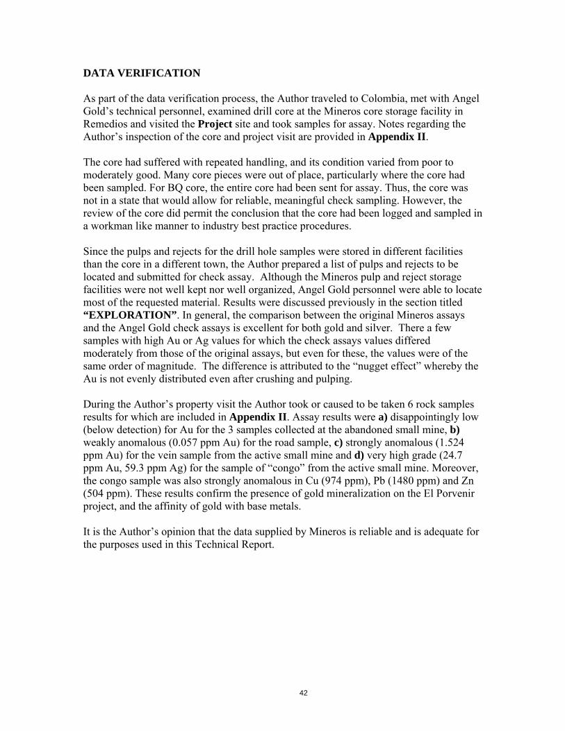
DATA VERIFICATION
As part of the data verification process, the Author traveled to Colombia, met with Angel Gold’s technical personnel, examined drill core at the Mineros core storage facility in Remedios and visited the Project site and took samples for assay. Notes regarding the Author’s inspection of the core and project visit are provided in Appendix II.
The core had suffered with repeated handling, and its condition varied from poor to moderately good. Many core pieces were out of place, particularly where the core had been sampled. For BQ core, the entire core had been sent for assay. Thus, the core was not in a state that would allow for reliable, meaningful check sampling. However, the review of the core did permit the conclusion that the core had been logged and sampled in a workman like manner to industry best practice procedures.
Since the pulps and rejects for the drill hole samples were stored in different facilities than the core in a different town, the Author prepared a list of pulps and rejects to be located and submitted for check assay. Although the Mineros pulp and reject storage facilities were not well kept nor well organized, Angel Gold personnel were able to locate most of the requested material. Results were discussed previously in the section titled“EXPLORATION”. In general, the comparison between the original Mineros assays and the Angel Gold check assays is excellent for both gold and silver. There a few samples with high Au or Ag values for which the check assays values differed moderately from those of the original assays, but even for these, the values were of the same order of magnitude. The difference is attributed to the “nugget effect” whereby the Au is not evenly distributed even after crushing and pulping.
During the Author’s property visit the Author took or caused to be taken 6 rock samples results for which are included in Appendix II. Assay results were a) disappointingly low (below detection) for Au for the 3 samples collected at the abandoned small mine, b)weakly anomalous (0.057 ppm Au) for the road sample, c) strongly anomalous (1.524 ppm Au) for the vein sample from the active small mine and d) very high grade (24.7 ppm Au, 59.3 ppm Ag) for the sample of “congo” from the active small mine. Moreover, the congo sample was also strongly anomalous in Cu (974 ppm), Pb (1480 ppm) and Zn (504 ppm). These results confirm the presence of gold mineralization on the El Porvenir project, and the affinity of gold with base metals.
It is the Author’s opinion that the data supplied by Mineros is reliable and is adequate for the purposes used in this Technical Report.
42

MINERAL PROCESSING AND METALLURGICAL TESTING
Neither Angel Gold, who only recently acquired the El Porvenir project, nor Mineros, the previous project owner, has conducted any mineral processing or metallurgical testing on material from the El Porvenir project.
43

MINERAL RESOURCE ESTIMATES
No mineral deposit has been delineated on the El Porvenir project. Consequently, neither Angel Gold, who only recently acquired the El Porvenir project, nor Mineros, the previous project owner, has completed mineral resource estimates.
44

ADJACENT PROPERTIES
Gran Colombia Gold’s Segovia operation, located approximately 5.0 km NW of the western margin of El Porvenir, currently produces ~80,000 oz Au per year from four underground mines (Providencia, Las Verticales, Sandra K and El Silencio) plus material supplied by contract miners. Total production from this area between 1869 and 2012 is estimated to be ~5.0 million oz. Au (Gran Colombia website www.grancolombiagold.ca). Resources at 3.0 g/t cut-off grade, as estimated by Parsons (2013), were 709,000 tonnes at 16.8 g/t Au in the measured and indicated categories and 1,962,000 tonnes grading 9.5 g/t Au in the inferred.
The deposits are hosted by the Segovia batholith. In each deposit, gold occurs in a series of quartz-sulphide veins. The main sulphide minerals present are pyrite, chalcopyrite, sphalerite and galena, and the higher gold grades are associated with higher grades of Zn (contained in sphalerite) and Pb (in galena). Commonly, the veins follow 2-3m wide basic dykes. The maximum vein thickness is 9.0 m, but the average vein thickness is 0.95 m (Parsons, 2013).
As indicated below in Table 9 the veins may be traced for extensive distances, but the orientations of the vein sets in each of the deposits are different (Parsons, 2013). The Las Verticales veins strike towards MCC 6717 (Figure 4), and was the target for the Mineros soil sample program along the 140o trend that cuts the SW corner of MCC 6717.
Table 9 : Segovia Project Vein SetsVein Set Strike Dip Distance
traced (km) Providencia 100o 30 o NE 2.0Las Verticales 140 o 75 o NE 1.3Sandra K 009 o 29 o E 1.3El Silencio 050 o 27 o SE 2.2
The Los Bancos and El Rayo clusters of active and abandoned artisan mines occur ~4 km north and the El Diamante cluster ~8 km north of MCC 6717, and lie within the Mineros Remedios project area. At Los Bancos the artisan workings lie along a 340o
trend for ~300 m. The vein exposed in the workings is hosted in andesite volcanic rocks, averages 0.7m thick, strikes 015o on average and dips between 5o and 20o westward. The best grade for a channel sample taken by Mineros personnel from the workings assayed 12.35 g/t Au and 12.35 g/t Ag over a width of 0.7 m (Rodriguez, 2011 and Botero, 2012).
The El Rayo mines also are hosted in andesite, and occur along an approximate 200o
trend. Here the vein strikes ~225 o, dips 25 o – 40 o NW and averages 0.8 m thick. The highest values for a sample taken by Mineros personnel from these workings were 20.60 g/t Au and 15.40 g/t Ag over a 0.55m thickness. Other workings occur at lower elevations, indicating the possible presence of stacked veins (Rodriguez, 2011 and Botero, 2012).
45

There is little information for the El Diamante area. It appears to be near the contact between the Segovia batholith intrusion and andesite volcanic rocks. Nine channel samples collected by Mineros personnel assayed low for both Au and Ag (Botero, 2012).
The importance of the Segovia – Remedios area is highlighted by the fact that 5 million ounces of gold have been produced over the last 150+ years.
Just the occurrence of Au bearing quartz veins in the Los Bancos and El Rayo areas within volcanic rocks signifies that exploration in the volcanic / sedimentary rock units in the central part of the El Porvenir project is justified.
The Author has been unable to independently verify the information from the adjacent properties. Moreover, the information for the adjacent properties is not necessarily indicative of the mineralization on the El Porvenir project that is the subject of this technical report.
46

OTHER RELEVANT DATA AND INFORMATION
To the Author’s knowledge, all relevant data and information are included in this report.
47
INTERPRETATION AND CONCLUSIONS
Angel Gold has acquired the right to earn a 100% interest in the 59.46 km2 El Porvenir gold project. Positive aspects of the project include:
The El Porvenir project lies within the Segovia gold belt, the most prolific gold belt in Colombia. Moreover, the project is located in close proximity to Gran Colombia’s Segovia operation which has produced more than 5 million ounces of Au.
The existence of small scale mines plus the previous work of Mineros is proof that gold exists on the property in four main areas – Bominas, Abejero, Guayabales and Iguana. Three styles of mineralization are recognized; high Au – low Ag, high Ag – low Au and high Au – high Ag.
Despite the extensive work conducted by Mineros, the Project area has not been systematically explored. A 4 km wide north / south swath of land through the center of The Project has been barely examined.
The gold mineralization at Gran Colombia’s Segovia operation occurs in quartz-sulphide vein systems hosted by granodiorite intrusive rocks. Elsewhere in the immediate area and at the El Porvenir project gold occurs in similar quartz-sulphide veins hosted by volcanic and gneissc rocks.
Core drilling conducted by Mineros cut several high grade intercepts (Table 2),These have yet to be subjected to follow-up exploration, and are thus immediate targets for additional work.
There are risks associated with any mineral exploration / mining project. Such risks may relate to the political stability of the jurisdiction, security of the area, commodity price fluctuations, environmentally sensitivity of the area, whether or not the area is prone to natural hazards such as hurricanes, floods, earthquakes, etc., to name a few. None of these risks are considered by the Author to be significant at this time. Colombia is a stable democracy, and the country, and Antioquia in particular, has / have a long history of mineral production. The army has a presence in the area which can handle any security concerns. There are no known environmental concerns. The very small part of the forest reserve along the east project boundary is not critical to The Project. The area is not prone to natural disasters.
For the El Porvenir project the main risk at this early exploration stage would be the inability to define a mineral deposit of sufficient size and grade that would be economical to mine. Such inability would lead to the termination of The Project or to consider other lands adjacent to or in the immediate vicinity.
48

RECOMMENDATIONS
The El Porvenir project is a “Property of Merit”. Regardless of the considerable amount of work completed previously by Mineros, The Project is at an early exploration stage. The recommended two phased exploration program that follows, if implemented, will advance the understanding of the styles and controls of mineralization in particular and the economic potential of the property in general. The implementation of all or any part of Phase II is dependent upon the results for Phase I.
Phase I
Stream Sediment Geochemistry
Conduct a stream sediment geochemical survey across the entire Project area. Such a survey is an effective method to quickly define areas for further exploration activities. This type of survey will be of particular usefulness to assess the ~4 km wide swath in the central Project area where Mineros apparently conducted little work. The minimum recommended sample density is one sample per km2 (60 samples), but allow for an additional 30 follow-up samples in selected areas (90 samples) total. Since Au and Ag values in the region are associated with base metal, particularly Pb and to a lesser extent Zn & Cu, analysis of the stream sediment samples include a base metal package.
During the stream sediment sampling program prospect for quartz (- sulphide) veins, and sample accordingly. Allow for 30 such rock samples.
Trenching
Mechanically dig a series of trenches in selected areas. Possible reasons that a significant percentage of the Mineros drill holes did not cut any significant mineralization are a) the targeted vein(s) is (are) discontinuous, b) rather than there being a single, continuous vein there are a series of veins in multiple directions (as indicated by measurements of veins in outcrops and artisan mine workings) or c) a combination of a and b. Trenches are to be dug in areas with interesting Au and / or Ag assay results for rock samples but negative or less than expected results for core samples. Data collected from the trenching program will help determine the density and attitudes of quartz veins in the respective area, and aide in the planning of future drill programs.
There are two obvious areas that would benefit from an immediate trenching program; at Guayabales particularly near hole RBGDDH-049 and at Bominas in the vicinity of the Pedro Castrillon mine. Another possibility is the Iguana area in the vicinity of the artisan mines sampled during the property visit. Allow for ~1000 m of trenches total. On average sample the trenches at 1.0 m intervals. Assay for Au, Ag and a multi element suite. Establish a rigorous QA /QC regime.
49
Core Re-logging
All Mineros drill core is to be re-logged with specific attention paid to establishing any differences between those quartz veins with high Au – low Ag, high Ag – low Au or high Au & high Ag assays.
Environmental Baseline Studies
A preliminary environmental baseline study is to be initiated. Water samples are to be collected at strategic locations on a regular basis. All artisan small scale mines, some of which are still active, both within and immediately outside the Project area are to be photographed and documented as to location, type (placer, or underground), size, etc.
Phase II
Drill Hole Twining
The reasons behind the twining of prior drill holes are 1) to confirm the assay intercept grades, 2) to determine, by drilling a larger diameter hole, if there is any significant difference in average grade (and thus determine if historic intercept grades are reliable) and 3) to confirm the geological data collected by the Mineros geologist particularly with respect to lithologies, vein measurements and vein mineralogy. Two priority holes for twining are RBGDDH-049 and RCGDDH-009.
RBGDDH-049 in the Guayabales area was drilled BQ. The entire core was sent for assay, thus there is no way to cross check the geological observations, other than with the core photos taken by Mineros prior to logging and sampling. The hole cut a 9.0 m interval that averaged 0.76 g/t Au and 88 g/t Ag. This interval is the thickest for any Mineros drill hole. The hole was drilled where veins had been mapped at oblique angles to the drill hole. Thus, not only is it important to confirm the average grade, it is equally important to confirm the length of the intercept for although it is most certainly not the true width of the mineralization it implies a thickness that may at a later date be amenable to bulk mining.
RCGDDH-009 in the Bominas area cut 3 intercepts, 2 with high grade Ag (420 & 441 g/t Ag) and one of Au (9.74 g/t Au). The gold intercept length of 2.35 m is considerably thicker than most mapped veins in the area (generally <0.5 m thick). This intercept might indicate a thicker “shoot” within the vein and represent a more economic target. Although gold is the element of interest, the high silver assays represent a different but potentially economic style of mineralization. The intercepts of high Ag in the Mineros drill hole must be confirmed, and any differences in the host quartz vein or the style of mineralization noted.
Both holes to be twinned are located in areas where quartz veins with various attitudes have been mapped. Therefore, based upon the data collected during the trenching program, at the same time as the holes are twinned two or three additional
50

holes are to drilled in the same areas to determine the optimal hole direction for future drill programs.
All samples selected are to be assayed for Au, Ag and a multi element suite. The rigorous QA / QC regime is to be maintained.
Environmental Baseline Studies
The environmental baseline studies are to be continued.
The total costs for the recommended program, as detailed in Table 10, are US$ 92,000.00 for Phase I and US $340,000.00 for Phase II.
Respectfully submitted,
James G. Burns B.Sc., P.Eng.
Effective Date : January 08, 2015 Signing Date : January 12, 2015
51

Table 10: Proposed Program BudgetPhase 1 Activity Cost Item COP $ US Str. Sed. Survey Analysis for 90 samples 4,840,000.00 2,200.00
Analysis for 30 rock samples 1,650,000.00 750.00 Wages 15,400,000.00 7,000.00 Supervision 4,840,000.00 2,200.00 Vehicle expenses 4,400,000.00 2,000.00 Security 6,600,000.00 3,000.00 Room & board 9,240,000.00 4,200.00 Miscellaneous 2,200,000.00 1,000.00
Trenching Machine rental, operator, fuel 12,100,000.00 5,500.00 Wages: geologist & helper 15,400,000.00 7,000.00 Allow 1000 samples 55,000,000.00 25,000.00 Vehicle expenses 4,400,000.00 2,000.00 Room & board 11,000,000.00 5,000.00 Security 6,600,000.00 3,000.00 Miscellaneous 1,100,000.00 500.00
Re-logging Wages 5,500,000.00 2,500.00 Vehicle Expense 4,400,000.00 2,000.00 Room & board 3,300,000.00 1,500.00 Security 2,200,000.00 1,000.00 Miscellaneous 2,200,000.00 1,000.00
Enviro. Studies Allow 11,000,000.00 5,000.00 Sub Total 183,700,000.00 83,350.00
Contingency 10.4% 19,030,000.00 8,650.00 Total Phase 1 202,400,000.00 $ 92,000.00
Phase 2 Core Drilling Allow 1000 m 462,000,000.00 210,000.00
Wages geologist + helper 19,800,000.00 9,000.00 Assays: allow 300 17,600,000.00 8,000.00 Field supervision & office support 110,000,000.00 50,000.00 Core shack & core saw rental 30,800,000.00 14,000.00 Vehicle expenses 4,400,000.00 2,200.00 Room & board 11,000,000.00 5,000.00 Security 11,000,000.00 5,000.00 Miscellaneous 2,200,000.00 1,000.00
Enviro. Studies Allow 11,000,000.00 5,000.00
Sub Total 680,240,000.00 309,200.00Contingency 10.0% 67,760,000.00 30,800.00
Phase 2 Total 748,000,000.00 $ 340,000.00Grand Total 950,400,000.00 $ 432,000.00
2,200 COP = 1.00 USD
52

REFERENCES
Alvarez G., M., Ordonez C., O., Valencia M., M. & Romero H., A. 2007. Geologia de la zona de influenza de la falla Otu en el distrito Sergovia-Remedios; Dyna, Universidad Nacional de Colombia, Medellín, vol. 74. no. 153, pp. 41-51.
Andrews, C.J. 2013. Touchstone Mining Holdings Ltd. Technical report and preliminary mineral resource estimate for the Rio Pescado Project, Department of Antioquia, Republico of Colombia; NI 43-101 report dated December, 2013, 219p.
Barrientos, D., and Botero, A. 2012. Informe Final etapa III Blanco Guayabales, proyecto Remedios (Remedios-Antioquia); Mineros company report, 38p.
Botero, A. M. 2012. Proyecto Remedios, Segovia-Antioquia, informe final de actividads; Mineros company report dated diciembre 2012, 18p.
Gonzalez, H. 1992. Mapa geologico de Colombia, Plancha 106 – Liberia (Departemento de Antioquia); INGEOMINAS Memoria Explicativa, 17p.
Londono-Herrera, C, Manco, J., Echeverri, S., Teran, B., Gonzalez, J., Marin, M., Suarez, E., Banquez, K., Naranjo, C., and Ordonez C., O. 2007 Cartographia geologica de la parte alta de la cuenca del Rio Bagre en el municipo de Remedios; Geologia de campo I, Facultad de Minas, Universidad Nacional de Colombia, sede Medellín; student field report dated novembre 2007, 29p.
Parsons, B. 2013. NI43-101 technical report on a mineral resource estimate on the Segivia and Carla operations, Department of Antioquia, Colombia; SRK consulting (UK) Limited report prepared for Zandor Capital, dated September, 2013, 120p. + appendices.
Ricaurte, M. 2013. Colombia; The Mining Law Review, second edition, Erik Richer La Fleche ed,. Colombia, pp.59-68.
Rodriquez, J.M. 2012 Informe anual 2011, proyecto Remedios; Mineros company report dated enero 2012, 21p.
Sillitoe, R.H. 2008. Major gold deposits and belts of the North and South American Cordillers: distribution, tectomagmatic setting and metallogenic considerations; Economic Geology special paper, vol. 103, pp. 663-687.
53

CERTIFICATE FOR
JAMES G. BURNS
I, James G. Burns, P.Eng., do hereby certify that:
1. I am currently self-employed as a geologist and reside at 405 Geraldine Street, Shediac, New Brunswick, Canada. E4P 1T4
2. I graduated with a B.Sc. Degree in Geological Sciences (Honours) from Queen’s University in 1969.
3. I am a member of the Association of Professional Engineers of Ontario.
4. I have worked as a geologist for a total of 45 years since my graduation from university. I have worked on gold projects in Canada, Venezuela, Ghana, Indonesia and Mexico.
5. I have read the definition of “qualified person” set out in National Instrument 43-101 (NI 43-101) and certify that by reason of my education, affiliation with a professional organization (as described in NI 43-101) and my past relevant work experience, I fulfill the requirements to be a “qualified person” for the purpose of NI 43-101.
6. I am responsible for all items / sections of this technical report titled “NI 43-101 Technical Report for the El Provenir Project, Antioquia Department, Colombia” and dated January 12, 2015 (the Technical Report).
7. I have had no prior involvement with the El Porvenir project nor with Mineros’ Remedios property.
8. I visited the property on December 05, 2014, and reviewed drill core from the property on December 4, 2014.
9. As of the date of this certificate, I am not aware of any material fact or material change with respect to the subject matter of the technical Report that is not reflected in the Technical Report, the omission of which makes the report misleading.
10. I am independent of the issuer and the vendor applying all of the tests in Section 1.5 of NI 43-101.
11. I have read NI 43-101 and Form 43-101F, and the Technical Report has been prepared in compliance with the instrument and form.
12. I consent to the filing of the Technical Report with any stock exchange and other regulatory authority and the publication by them, including electronic publication in the public company files on their website accessible by the public, of the Technical Report.
January 12, 2015 James G. Burns B.Sc, P.Eng.
54

APPENDIX I
Letter of Authorization
55

________________________________________________________________________
November 25, 2014
Mr. James G. Burns, P.Eng., 405 Geraldine Street, Shediac, New Brunswick, E4P 1T4, Canada.
Dear James:
On behalf of Angel Gold Corp. (“Angel Gold” or the “Company”) I hereby authorize you as a Qualified Person under the regulations of National Instrument 43-101, to visit the Company’s recently optioned “El Porvenir” property located in Remedios and Segovia municipalities, Antioquia Department, Colombia, and to prepare a technical report (the “Report”) thereon. The Report will (a) comply in form and substance with the guidelines set out in National Policy 43-101, (b) include such recommendations (with cost estimates) for further exploration work as you see fit, in accordance with best industry practice, and (c) include your consent allowing Angel Gold to use the Report and your name in Company disclosure documents and for any corporate purpose normal to its business.
The purpose of the Report is to satisfy TSX Venture Exchange continuous disclosure requirements. The Report may also be used to support a Company initiated financing or to satisfy other TSX Venture Exchange regulatory requirements, provided the data therein is both current and Relevant.
Yours sincerely,
Angel Gold Corp.
Blanca Stella Frias, President and CEO.

APPENDIX II
Notes Re
Visit to the El Porvenir Project December 3 to 6, 2014
56

Notes Re Visit to the El Porvenir Project, December 3 – 6, 2014
December 3, 2014
At the Angel Gold office in Medellin Met with Sra. Blanca Stella Frias (President of Angel Gold Corp.), Mr. James Stephenson (Angel Gold Corp. VP Exploration designate), Sr. Vladimir Vergara (Angel Gold Field Geologist). Reviewed and discussed the data supplied by Mineros re The Project.Also met with Srta. Ana Maria Alvarez (geologist and former employee of Angel Gold who previously had reviewed the Project data) and Sr. Andres Botero (geologist and former employee of Mineros who had worked on the Remedios project). Discussed the project in general.
December 4, 2014
Accompanied by Mr. James Stephenson and Sr. Vladimir Vergara traveled to the town of Remedios and reviewed drill core for Mineros holes RBG-49, RCG-09, RCG-16 and RCG-17 at the Mineros core storage facility.
o RBG-49 (Guayabales area): BQ core with a 9 m interval in granodiorite from 27.15 to 36.15 m that averages 0.76 ppm Au and 89.9 ppm Ag; entire core taken by Mineros for assay; material above and below the interval is strongly bleached, silica flooded and variably sericitic.
o RCG-09 (Bominas area): NQ core; an interval of oxidized fractures in un-weathered rock at 22.22 – 24.10 m assayed 420.0 ppm Ag; a second interval with minor py on fractures and minor sericite alteration at 39.95-41.40 m assayed 441.0 ppm Ag; a third interval in a weakly bleached altered zone with minor quartz, sericite and py assayed 9.74 ppm Au; all three intervals are narrow, display bleached alteration at best and except for the assay values are of little interest.
o RCG-16 (Bominas area): HQ to 16.5 m and NQ from 16.5 to end of hole; a 2.25 m interval with minor qtz vein from 31.00 – 33.25 m which assayed 23.0 ppm Au and 13.5 ppm Ag occurs at the contact between silicified & bleached gneiss above and unaltered gneiss below; other samples of the altered gneiss were very low grade.
o RGC-17 (Bominas area): NQ core; bleached gneiss ~78.4 – 88.7 m. interval from 83.4-84.4 m with sericite-chlorite alteration and minor qtz veins +/- carbonate and very minor po assayed 39.4 ppm Au & 15.7 ppm Ag.
The core was not in a state that would allow for reliable, meaningful check sampling.
December 5, 2014
Visited the Project site accompanied by Mr. James Stephenson, Sr. Vladimir Vergara, Sr. Ronald Aguinaga and Sr. Anderson Aguinaga (the latter two persons
57

had worked on the project for Mineros and were familiar with the area) examined three artisan mine workings in the SW corner of concession contract 6717 in an area known as Iguana and collected six rock samples, detailed below, for assay.
Sample #
Au(ppm)
Ag (ppm)
Description
151 < 0.005 <0.1 777,502 N, 537,463 E**: Abandoned mine; representative dump sample; qtz vein with cockscomb texture; iron oxide on fractures; wall rock strongly silicified and bleached.
152 < 0.005 1.4 Same site as above: grab sample taken ~10m underground from footwall of 30cm qtz vein; vein strikes ~250o (same as inclined shaft) and dips south; qtz vein banded, cockscomb with iron oxide fractures.
153 < 0.005 1.1 Same site as above: 2.5 cm qtz vein in silicified wall rock cut at 35o by an iron oxide lined fracture.
154 0.057 3.6 777,525 N, 537,546 E**: 777,664 N, 537,331 E: old, overgrown, abandoned adit at 220o; adit unsafe and therefore not entered; no sample.
155 1.524 4.9 777,710 N, 537,304 E**: active mine; qtz vein with iron oxide fractures; grab sample from underground across 30 cm thick vein; vein strikes 100o
and dips 45o N; wall rock bleached and sericitized granodiorite. 156 24.7 59.3 Same active mine: sample of “congo” material from dump; desired
material by the miners; heavy, black and red oxide material with py boxes.
** UTM coordinates, WGS 84 datum, zone 18N.
With the exception of sample 154 which was collected by Mr. James Stephenson, The Author collected or supervised the collection of the samples. All six samples were bagged, tagged and secured in the field and then delivered by Angel Gold personnel to the Actlabs facility in Medelin for preparation and assay.
At Actlabs the samples were prepared according to code RX-1, assayed for Au by method 1A2 (over limits by 1A4 Metallic Sieve), and for multi-elements by code 1DX. The assay certificates are included herein.
December 6, 2014
Met again with Sra. Blanca Stella Frias (President of Angel Gold Corp.), Mr. James Stephenson and Sr.Vladimir Vergara, and reviewed and further discussed the data supplied by Mineros.
58

CERTIFICADO DE ANALISIS
Tecnologías Innovadoras Análisis de la Calidad ...
Factura No.:
Fecha de Factura:
Fecha de Presentacion:
Su referencia:
12-Dec-14
09-Dec-14
COL14-0228 (i)
Jose Vladimir Vergara BustosATT:
Este reporte puede ser reproducido sin nuestro concentimiento. Si solo algunas partes del reporte van a ser reproducidas se debe obtener permiso. Si al momento de recibir las muestras no se indica la disposicion del material sobrante este va a ser desechado durante los 90 dias posteriores a la emission de este reporte. Nuestra responsabilidad esta solamente limitada al costo analitico de este analisis. Los resultados de esta prueba son solo representativas al material entregado para analisis.
ACTLABS COLOMBIA S.A.S.
Vereda Chachafruto - Zona Franca Rionegro - Bodegas 172 y 173 - Antioquia - Colombia - Tel: 57 4 5623651
E-MAIL [email protected] WEBSITE www.actlabs.com
Jhoan Jaimes
CERTIFICADO POR:
REPORT COL14-0228 (i)
Nota:
Code 1A2 Au - Ensayo al Fuego AACode 1A4 (150 mesh) Au-Fire Assay-Metallic Screen-500gCode AQ1-AR Ag Agua Regia - AA
Laboratory Supervisor
El siguiente paquete de analisis ha sido requerido::
ANGEL GOLD S.A.S
Carrera 43A #1A S-69 Oficina 501
6 Roca samples de muestras que se sometieron para analisis.

Act
ivat
ion
Lab
ora
tori
es L
td.
Rep
ort
:C
OL
14-0
228
(i)
Au
Ag
AR
Tot
al A
u-1
50 m
esh
+15
0 m
esh
Au
-150
m
esh
(A)
Au
-150
m
esh
(B)
- 15
0 m
esh
Au
+ 1
50
mes
hT
otal
W
eigh
tS
imb
olo
An
alit
o
ppm
ppm
g/m
tg
gg/
mt
g/m
tg/
mt
g/m
tg
Un
idad
es0.
005
0.1
0.07
0.07
0.07
0.07
0.07
Lim
ite
det
ecci
on
EF
-AA
AR
-AA
FA
-MeT
FA
-MeT
FA
-MeT
FA
-MeT
FA
-MeT
FA
-MeT
FA
-MeT
FA
-MeT
Co
dig
o d
el M
eto
do
< 0
.005
< 0
.100
151
< 0
.005
1.4
0015
2
< 0
.005
1.1
0015
3
0.05
73.
600
154
1.52
44.
900
155
> 5
.000
59.3
290.
7011
.33
0015
624
.924
.824
.921
.330
2.04
24.7
Pag
e 2
of 3

Act
ivat
ion
Lab
ora
tori
es L
td.
Rep
ort
:C
OL
14-0
228
(i)
Qu
alit
y C
on
tro
l
Au
Ag
AR
Sim
bo
lo A
nal
ito
ppm
ppm
Un
idad
es0.
005
0.1
Lim
ite
det
ecci
on
EF
-AA
AR
-AA
Co
dig
o d
el M
eto
do
1.31
7C
DN
-GS
-1P
5F S
TD
La
b.
1.40
CD
N-G
S-1
P5F
ST
D c
ert
< 0
.005
< 0
.100
151
Spl
it
< 0
.005
< 0
.100
151
Spl
it O
rigin
al
< 0
.005
< 0
.100
151
Spl
it B
lk
0.05
63.
500
154
Ori
gina
l
0.05
83.
800
154
Dup
. Lab
.
< 0
.005
Bla
nco
Lab.
< 0
.1B
lanc
o La
b.
Pag
e 3
of 3

CERTIFICATE OF ANALYSIS
Innovative Technologies Quality Analysis ...
Invoice No.:
Invoice Date:
Date Submitted:
Your Reference:
30-Dec-14
COL14-0228
12-Dec-14
A14-09780
Angel Gold S.A.S
Carrera 43A#1AS-69Oficina 501,Medellin
Jose Vladimir Vergara BustosATTN:
This report may be reproduced without our consent. If only selected portions of the report are reproduced, permission must be obtained. If no instructions were given at time of sample submittal regarding excess material, it will be discarded within 90 days of this report. Our liability is limited solely to the analytical cost of these analyses. Test results are representative only of material submitted for analysis.
ACTIVATION LABORATORIES LTD.
1336 Sandhill Drive, Ancaster, Ontario Canada L9G 4V5 TELEPHONE +1.905.648.9611 or +1.888.228.5227 FAX +1.905.648.9613
E-MAIL [email protected] ACTLABS GROUP WEBSITE www.actlabs.com
Emmanuel Eseme , Ph.D.
CERTIFIED BY :
REPORT A14-09780
Notes:
6 Pulp samples were submitted for analysis.
Code 1DX Aqua Regia ICP/MS
Note: Au by this package is not reliable and you should have Au by Fire Assay done if you need accurate Au values.
Quality Control
The following analytical package was requested:

Act
ivat
ion
Lab
ora
tori
es L
td.
Rep
ort
:A
14-0
9780
Ag
Al
As
Au
BB
aB
iC
aC
dC
oC
rC
uF
eG
aH
gK
LaM
gM
nM
oN
aN
iP
Pb
An
alyt
e S
ymb
ol
ppm
%pp
mpp
bpp
mpp
mpp
m%
ppm
ppm
ppm
ppm
%pp
mpp
m%
ppm
%pp
mpp
m%
ppm
%pp
mU
nit
Sym
bo
l0.
10.
010.
50.
520
0.5
0.1
0.01
0.1
0.1
10.
10.
011
0.01
0.01
10.
011
0.1
0.00
10.
10.
001
0.1
Det
ecti
on
Lim
itA
R-M
SA
R-M
SA
R-M
SA
R-M
SA
R-M
SA
R-M
SA
R-M
SA
R-M
SA
R-M
SA
R-M
SA
R-M
SA
R-M
SA
R-M
SA
R-M
SA
R-M
SA
R-M
SA
R-M
SA
R-M
SA
R-M
SA
R-M
SA
R-M
SA
R-M
SA
R-M
SA
R-M
SA
nal
ysis
Met
ho
d
< 0
.10.
234.
4<
20
0015
16.
80.
10.
010.
20.
85
24.9
1.39
< 1
0.14
0.06
< 1
0.01
710.
30.
005
2.4
0.00
49.
85.
0
< 0
.10.
07<
0.5
< 2
000
152
5.4
0.6
< 0
.01
0.1
0.3
43.
00.
85<
10.
020.
04<
1<
0.0
166
0.1
0.00
92.
20.
001
8.9
0.8
1.4
0.22
< 0
.5<
20
0015
349
.4<
0.1
< 0
.01
0.6
9.3
4811
51.
21<
10.
070.
081
0.01
1220
7.4
0.00
66.
20.
009
118
7.8
4.0
1.24
88.9
< 2
000
154
137
0.3
< 0
.01
0.4
4.5
1434
712
.32
0.19
0.26
40.
0368
33.
20.
005
2.0
0.06
214
593
.9
5.8
0.16
> 1
000
< 2
000
155
2.8
1.2
< 0
.01
0.2
0.6
1943
.64.
38<
1<
0.0
10.
08<
1<
0.0
179
1.4
0.00
11.
90.
006
98.7
251
62.0
0.33
> 1
000
< 2
000
156
6.2
13.1
< 0
.01
1.3
9.2
219
974
42.6
< 1
0.26
0.04
40<
0.0
120
13.4
0.00
318
.30.
063
1480
2250
Pag
e 2
of 5

Act
ivat
ion
Lab
ora
tori
es L
td.
Rep
ort
:A
14-0
9780
SS
bS
cS
eS
rT
eT
hT
iT
lV
WZ
nA
nal
yte
Sym
bo
l%
ppm
ppm
ppm
ppm
ppm
ppm
%pp
mpp
mpp
mpp
mU
nit
Sym
bo
l1
0.1
0.1
0.5
10.
20.
10.
001
0.1
20.
11
Det
ecti
on
Lim
itA
R-M
SA
R-M
SA
R-M
SA
R-M
SA
R-M
SA
R-M
SA
R-M
SA
R-M
SA
R-M
SA
R-M
SA
R-M
SA
R-M
SA
nal
ysis
Met
ho
d
< 1
0.2
< 0
.52
0015
1<
0.2
0.6
0.00
1<
0.1
6<
0.1
580.
7
< 1
< 0
.1<
0.5
100
152
< 0
.20.
20.
001
< 0
.1<
2<
0.1
6<
0.1
< 1
0.2
< 0
.54
0015
3<
0.2
0.5
0.00
20.
24
< 0
.156
1.2
< 1
1.5
1.5
500
154
< 0
.21.
70.
001
0.2
14<
0.1
269
14.1
< 1
0.9
0.6
< 1
0015
5<
0.2
0.2
0.00
1<
0.1
< 2
< 0
.146
0.9
< 1
8.2
4.9
< 1
0015
6<
0.2
0.6
< 0
.001
< 0
.1<
2<
0.1
504
3.7
Pag
e 3
of 5

Act
ivat
ion
Lab
ora
tori
es L
td.
Rep
ort
:A
14-0
9780
Qu
alit
y C
on
tro
l
Ag
Al
As
Au
BB
aB
iC
aC
dC
oC
rC
uF
eG
aH
gK
LaM
gM
nM
oN
aN
iP
Pb
An
alyt
e S
ymb
ol
ppm
%pp
mpp
bpp
mpp
mpp
m%
ppm
ppm
ppm
ppm
%pp
mpp
m%
ppm
%pp
mpp
m%
ppm
%pp
mU
nit
Sym
bo
l0.
10.
010.
50.
520
0.5
0.1
0.01
0.1
0.1
10.
10.
011
0.01
0.01
10.
011
0.1
0.00
10.
10.
001
0.1
Det
ecti
on
Lim
itA
R-M
SA
R-M
SA
R-M
SA
R-M
SA
R-M
SA
R-M
SA
R-M
SA
R-M
SA
R-M
SA
R-M
SA
R-M
SA
R-M
SA
R-M
SA
R-M
SA
R-M
SA
R-M
SA
R-M
SA
R-M
SA
R-M
SA
R-M
SA
R-M
SA
R-M
SA
R-M
SA
R-M
SA
nal
ysis
Met
ho
d
3.5
2.73
447
< 2
0G
XR
-4 M
eas
7.5
18.2
0.86
< 0
.113
.552
6160
2.95
110.
121.
7454
1.48
124
312
0.12
442
.00.
117
40.6
107
4.0
7.20
470
4.50
GX
R-4
Cer
t16
4019
.01.
010.
860
14.6
64.0
6520
3.09
20.0
0.11
04.
0164
.51.
6615
531
00.
564
42.0
0.12
052
.098
.0
0.3
7.95
< 2
0G
XR
-6 M
eas
920
0.2
0.17
0.3
13.4
8775
.35.
8718
< 0
.01
1.34
130.
4296
50.
50.
066
27.1
0.03
499
.424
5
1.30
17.7
9.80
GX
R-6
Cer
t13
000.
290
0.18
01.
0013
.896
.066
.05.
5835
.00.
0680
1.87
13.9
0.60
910
102.
400.
104
27.0
0.03
5010
133
0
3.4
1.13
SA
R-M
(U
.S.G
.S.)
Mea
s18
21.
70.
285.
59.
886
337
2.68
50.
3149
0.32
3950
12.0
0.02
446
.80.
058
829
38.6
3.6
4
6.
30S
AR
-M (
U.S
.G.S
.) C
ert
801
1.94
0.61
5.27
1
0.70
79.7
331
.000
0
2
.99
17
2.9
4
57
.4
0
.50
522
0
13
.1
1.1
4041
.50.
07
9
82
38
.8
< 0
.10.
08<
0.5
< 2
000
152
Orig
5.9
0.6
< 0
.01
0.2
0.3
43.
10.
86<
10.
010.
04<
1<
0.0
166
0.2
0.01
02.
20.
001
8.9
0.9
< 0
.10.
07<
0.5
< 2
000
152
Dup
4.8
0.6
< 0
.01
0.1
0.3
43.
00.
85<
10.
030.
04<
1<
0.0
166
0.1
0.00
82.
20.
001
8.9
0.7
< 0
.1<
0.0
1<
0.5
< 2
0M
etho
d B
lank
<
0.5
< 0.
1<
0.0
1<
0.1
< 0
.1<
1<
0.1
< 0
.01
< 1
< 0
.01
< 0
.01
< 1
< 0
.01
< 1
< 0.
1<
0.0
01<
0.1
< 0
.001
< 0
.1<
0.5
< 0
.1<
0.0
1<
0.5
< 2
0M
etho
d B
lank
<
0.5
< 0.
1<
0.0
1<
0.1
< 0
.1<
1<
0.1
< 0
.01
< 1
< 0
.01
< 0
.01
< 1
< 0
.01
< 1
< 0.
1<
0.0
01<
0.1
< 0
.001
< 0
.1<
0.5
Pag
e 4
of 5

Act
ivat
ion
Lab
ora
tori
es L
td.
Rep
ort
:A
14-0
9780
Qu
alit
y C
on
tro
l
SS
bS
cS
eS
rT
eT
hT
iT
lV
WZ
nA
nal
yte
Sym
bo
l%
ppm
ppm
ppm
ppm
ppm
ppm
%pp
mpp
mpp
mpp
mU
nit
Sym
bo
l1
0.1
0.1
0.5
10.
20.
10.
001
0.1
20.
11
Det
ecti
on
Lim
itA
R-M
SA
R-M
SA
R-M
SA
R-M
SA
R-M
SA
R-M
SA
R-M
SA
R-M
SA
R-M
SA
R-M
SA
R-M
SA
R-M
SA
nal
ysis
Met
ho
d
11.
85.
473
GX
R-4
Mea
s0.
820
.20.
131
2.8
7510
.971
6.6
1.77
4.80
5.60
221
GX
R-4
Cer
t0.
970
22.5
0.29
3.20
87.0
30.8
73.0
7.70
< 1
0.4
0.8
30G
XR
-6 M
eas
< 0
.25.
12.
018
0<
0.1
132
25.6
0.01
603.
600.
940
35.0
GX
R-6
Cer
t0.
0180
5.30
2.20
186
1.90
118
27.6
2.2
1.6
29S
AR
-M (
U.S
.G.S
.) M
eas
0.9
11.4
0.05
60.
832
2.1
931
3.3
6.0
0.3
915
1S
AR
-M (
U.S
.G.S
.) C
ert
0.9
6
17
.20.
38
2
.767
.2
9.
78
930
.0
7.
83
< 1
< 0
.1<
0.5
100
152
Orig
< 0
.20.
20.
001
< 0
.1<
2<
0.1
5<
0.1
< 1
< 0
.1<
0.5
100
152
Dup
< 0
.20.
20.
001
< 0
.1<
2<
0.1
6<
0.1
< 1
< 0
.1<
0.5
< 1
Met
hod
Bla
nk
< 0
.2<
0.1
< 0
.001
< 0
.1<
2<
0.1
< 1
< 0
.1
< 1
< 0
.1<
0.5
< 1
Met
hod
Bla
nk
< 0
.2<
0.1
< 0
.001
< 0
.1<
2<
0.1
< 1
< 0
.1
Pag
e 5
of 5

APPENDIX III
Legal Opinion Regarding the Mining Concession Contracts
59


APPENDIX IV
Mining Concession Contract Coordinates
60

Concession Contract Coordinates (Bogota Datum)
Concession Contract No. Northing Easting6717 1,272,998.0000 935,002.0000
1,269,002.0000 935,002.00001,269,002.0000 939,998.00001,272,998.0000 939,998.00001,272,998.0000 936,602.00001,272,918,0000 936,602.00001,272,918,0000 935,127.00001,272,998.0000 935,127.0000
6832 1,274,350.0000 945,000.00001,273,000.0000 945,000.00001,273,000.0000 940,000.00001,277,000.0000 940,000.00001,277,000.0000 945,000.00001,274,351,0000 945,000.00001,274,351.0000 943,152.00001,274,950.0000 943,152.00001,274,950.0000 942,851.00001,274,349.0000 942,851.00001,274,349,0000 943,152.00001,274,350,0000 943,152.0000
6835 1,271,882.0000 945,000.00001,269,000.0000 945,000.00001,269,000.0000 940,000.00001,273,000.0000 940,000.00001,273,000.0000 945,000.00001,271,883.0000 945,000.00001,271,883.0000 942,888.00001,272,284.0000 942,888.00001,272,284.0000 942,383.00001,271,878.0000 942,383.00001,271,878.0000 942,888.00001,271,882.0000 942,888.0000
61